Huntington Station Metro Zone / North Kings Highway Concept Plan
|
|
|
- Vivian Thomas
- 6 years ago
- Views:
Transcription
1 Summary Narrative of Huntington Station Metro Zone / North Kings Highway Concept Plan Located in Fairfax County, Virginia prepared for A.J. Dwoskin & Associates, Inc Lee Highway, Suite 300 Fairfax, Virginia and Jefferson Gardens, LC c/o Johnson Associates, Inc Lee Highway Arlington, VA prepared by Patton Harris Rust & Associates (PHR+A) Lee Road Chantilly, Virginia
2 TABLE OF CONTENTS INTRODUCTION...3 EXISTING CONDITIONS...4 TRAFFIC SIGNAL OPERATIONS...6 EXISTING PEDESTRIAN ACCESS...6 PLANNED TELEGRAPH ROAD INTERCHANGE IMPROVEMENTS...7 CURRENTLY PROPOSED PEDESTRIAN IMPROVEMENTS...7 CURRENTLY PLANNED METRO SITE IMPROVEMENTS...7 PEDESTRIAN ACCESS ISSUES...11 PEDESTRIAN PLAN RECOMMENDATIONS...12 MEDIAN...13 RIGHT TURN LANES...14 PEDESTRIAN SIGNAL CONTROL...15 SPEED LIMIT REDUCTION...16 ON-STREET PARKING WITH REDEVELOPMENT WEST OF NORTH KINGS HIGHWAY...16 ENHANCED PEDESTRIAN CROSSWALKS...17 WEST SIDEWALK...17 OTHER CORRIDOR IMPROVEMENTS...17 METRO ZONES...18 PLAN EXHIBITS Existing Conditions Photographs, (source RTKL) I-95/Telegraph Road Interchange Concept North Kings Highway (Midblock) Illuminated Crosswalk Design Huntington METRO Station North Kings Highway, Suggested Pedestrian Improvements North Kings Highway Typical Cross-sections -2-
3 INTRODUCTION Patton Harris Rust and Associates (PHR+A) prepared this Pedestrian Access Improvement Concept Plan for the portion of N Kings Highway (Route 241) abutting the Huntington Metro Station at the request of A.J. Dwoskin and Associates and Jefferson Garden LLC., who own and manage property within this corridor. Under separate cover, the aforementioned property owners have proposed a Comprehensive Plan Amendment for a transit oriented development on their properties and have been talking to the surrounding community about a variety of concerns. This concept plan is proposed to assist in finding solutions that enhance pedestrian connectivity between the surrounding community, the proposed APR project and the Metro station and to ensure pedestrian safety, a major concerns identified by representatives of the Jefferson Manor Association and a major goal established in the Fairfax County Comprehensive Plan for this area. The project scope included a review of existing conditions and proposed development plans and improvements for the portion of the North Kings Highway Corridor spanning from Fort Drive to Jefferson Drive, a segment of approximately 1500 linear feet. The pedestrian concept plan proposes potential safety improvements that can be accomplished primarily through modest infrastructure upgrades within the existing right of way. The plan proposes to improve pedestrian access by clearly delineating the pedestrian environment, eliminating unnecessary conflicts between pedestrians and vehicle movements and reducing the amount of time that pedestrians are exposed to such potential conflicts and providing traffic calming measures. The improvements proposed in this concept plan are not specifically intended to represent a commitment from the property owners to fund such plan. The timing of the proposed redevelopment of the subject properties will not necessarily coincide with future proposals for the improvements. However, the plan is proposed for the purposes of discussion as to the appropriateness for potential incorporation of at least some of the measures for county s comprehensive plan. As part of the planning process, it is also suggested that the County may wish to consider the designation of certain areas adjacent to Metro Stations as METRO Zones. Distinguishing METRO pedestrian zones from other locations may increase the County s ability to work with VDOT to ensure pedestrian needs are integral to future plans and receive appropriate priority in these areas. This concept plan is envisioned as a first step toward developing a consensus among community member and County representatives about how to address these pedestrian safety issues and ultimately to ensure that future development is consistent with the goals of high quality transit oriented development established in the Comprehensive Plan. To realize a community-backed pedestrian plan, the follow-up steps should also be undertaken: 1) Planning and designing specific measures that reinforce safety and increase the aesthetic appeal of the pedestrian s journey to and from the Huntington Metro Station along N -3-
4 Kings Highway, 2) Prioritizing such improvements including timing goals, 3) Developing cost estimates, and 4) Identifying and allocating funding sources The report describes existing conditions, outlines pedestrian access issues and previous planned but unimplemented improvements, and recommends 12 generalized improvements for the study area with a brief justification of benefits. The narrative is provided to support our recommendations and provide a planning resource for future implementation. An aerial exhibit is also provided of the corridor to assist the reader in visualizing the proposed improvements. EXISTING CONDITIONS The corridor is located in southern Fairfax County west of the US Route 1 corridor and south of Alexandria. Typical conditions are attached from field photographs taken in October The public streets in the immediate area include: North Kings Highway (Rt. 241): is a four lane undivided Minor Arterial (Type B) roadway, as defined by the Fairfax County Comprehensive Plan, generally running north-south between US Route 1 and Telegraph Road. Adjacent to the Huntington METRO station, the terrain is level and the road cross-section includes a center turn lane for access to the adjacent properties. However, the section of the roadway north of Jefferson Drive (Rt. 1617) intersection to Telegraph Road (Rt. 611) comprises a significant downhill grade in the northwest direction. The posted speed limit is 35 mph. North Kings Highway is signalized at the following intersections: Telegraph Road (Rt. 611) Jefferson Drive (Rt. 1617)/ Kiss & Ride Entrance Existing Huntington Station/ Park & Ride Entrance Fort Drive (Rt. 1601) School Street (Rt. 1647) Richmond Highway (Rt. 1) Based on the most currently published VDOT counts, Route 241 accommodates 23,000 AADT (Average Annual Daily Traffic) in Fort Road (Va. Route 1601) is a two lane collector serving the residential neighborhoods. Based on the most recent VDOT counts, Fort Drive accommodates 2,100 AADT (Average Annual Daily Traffic) west of North Kings Highway and 2,500 AADT to the east.. -4-


5 Upper Left: North Kings Highway looking west from Kiss and Ride to Jefferson Drive Upper Right: North Kings Highway looking south from Kiss and Ride turn lane Lower Left: Existing crosswalk at shopping center Lower Right: Fort Drive north crosswalk to shopping center -5-
6 Farmington Drive (Va. Route 1616) extends west of North Kings Highway to Telegraph Road. Adjacent to North Kings Highway, the road section is one way westbound at Route 241 opposite the METRO station. Based on 2004 VDOT counts, Route 1616 accommodates 4,300 AADT east of Telegraph Road. Jefferson Drive (Va. Route 1617) is a two lane local roadway with one-way traffic pattern eastbound. Most recent traffic counts are from 1986 show 500 VPD Traffic Signal Operations VDOT 2005 signal operation data at the 3 intersections in the study area an effective Daily traffic of approximately 30,700 Vehicles Per Day (VPD) on North Kings Highway, interpolated with an assumed peak hour factor of 0.078, based on historical VDOT trends. The increase in volumes as compared to the 2004 AADT (23,000 upd) are associated with the large peak hour volumes. AM and PM peak hour traffic volumes conditions Levels of Service (LOS), as measured by average delay, is at LOS C or better during the peak hours, with a LOS D exiting the metro parking garage in the PM peak. The Level of Service is a term used by VDOT and Fairfax County to rate the efficiency of a roadway segment. As defined by the Highway Capacity Manual (HCM), the LOS of a traffic signal is measured by the average delay of the vehicles entering the intersection. LOS is measured in seconds and graded on a scale from LOS A to LOS F. For urban conditions both Fairfax County and VDOT establish LOS D as the maximum (or highest) delay for signal operations, reflecting average delay of approximately 55 seconds for LOS D conditions with a signal. Note that the LOS is a measure of delay, and may not exactly reflect the capacity of an intersection. Existing signal timing is at 90 seconds during the AM peak and at 85 seconds in the PM peak. The existing traffic signals are span wire design. Level of service is also applied to rank the performance of the pedestrian and bike facilities, and is typically measured in terms of continuity of service and density of activities (persons per square feet). Existing Pedestrian Access North Kings Highway has pedestrian crosswalks at the Fort Drive signal, with pedestrian button and phasing. At the Metro signal opposite the Huntington Station shopping center, the crosswalk has pedestrian phases on the north and east legs. To the north, the next crosswalk at Route 241 is on the south leg, but it is not signal activated. Signal control for the pedestrian movements are provided for the east and north legs at the North Kings Highway/Metro/Jefferson Drive signal. -6-
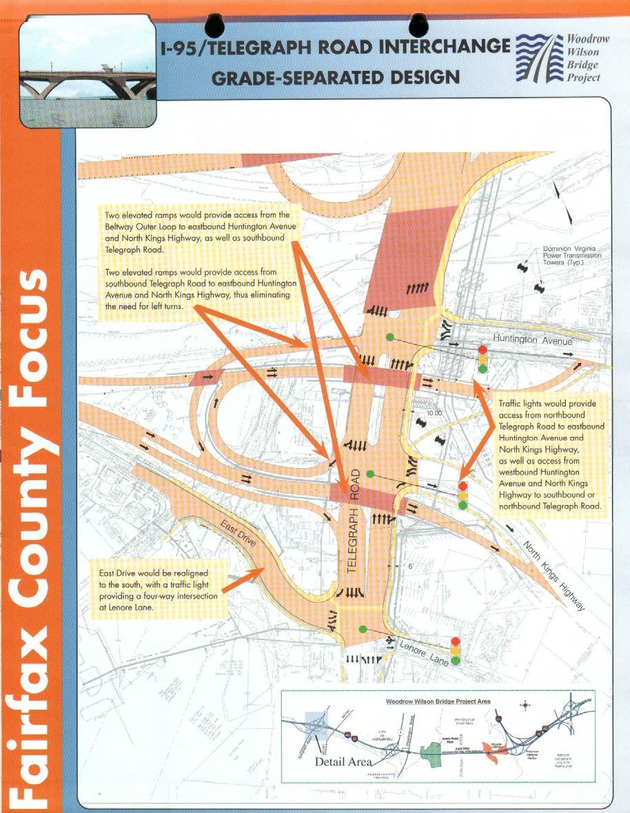
7 On both sides of North Kings Highway, there is a four foot wide sidewalk adjacent to the METRO property, the shopping center and the residences. The pedestrian access is wider adjacent to the METRO garage and kiss and ride lot. Access to the METRO station is via the north end of the garage. PLANNED TELEGRAPH ROAD INTERCHANGE IMPROVEMENTS As part of the Woodrow Wilson Bridge project, the I-95 (Capital Beltway) interchange at Telegraph Road will be reconstructed. The improvements modify the existing traffic signals at Huntington Avenue and at North Kings Highway south of the Beltway and introduce two new overpasses to provide I-95 NB access direct to Huntington Avenue and North Kings Highway without having to turn at Telegraph Road. The improvements at North Kings Highway also eliminates left turns on southbound Telegraph Road with a directional ramp to access North Kings Highway heading southbound. These improvements provide uninterrupted access from the Beltway to North Kings Highway, with the first signal control at Jefferson Street at the beginning of the METRO zone. Northbound traffic on North Kings Highway will still be controlled by a traffic signal at Telegraph Road, and pass through the Huntington Avenue signal to access I-95. The generalized improvements at I-95 and Telegraph Road with the new interchange and bridges for Huntington Avenue and North Kings Highway is shown on the next page. CURRENTLY PROPOSED PEDESTRIAN IMPROVEMENTS The County has been developing plans for a new crosswalk north of the METRO garage access at the corner of the Huntington Station Shopping Center. The crosswalk is designed as diagonal across King Highway with enhance ladder pavement markings and flashing warning lights embedded in the pavement, activated by a pedestrian crosswalk button. The alignment of the new walk is situated at the highest location of jaywalkers, as evidenced by the worn grass on the east side of North Kings Highway, adjacent to the Metro bus stops. The improvements were scheduled for construction to start this winter. However, PHR+A understands that some safety issues have delayed the project. Fairfax County Staff are studying the concerns about the effectiveness of the in-pavement lights for multi-lane roadways. The concept plan and a generalized location of the crossing are shown on the following page. CURRENTLY PLANNED METRO SITE IMPROVEMENTS As the METRO site is being developed as a mixed use project with a new METRO parking garage east of North Kings Highway, the northern METRO garage access will be shifted to the south by approximately 50 feet. The south garage entrance, which also connects to the atgrade parking lots, is to be relocated and designated as Huntington Park Drive. As part of the Pavilions at Huntington Metro development, the new road (opposite the existing traffic signal) -7-
8 will be widened to a five lane section at North Kings Highway and split into a Y road with the north leg accessing the METRO facilities and the east leg accessing the new mixed use development. This will cause an off set of the alignment crossing into the Huntington Station Shopping Center. New pedestrian facilities and a park are proposed with redevelopment. The access at the north garage driveway, accessing the top level of the garage, will be restricted to left turns in, and right turns in and out with the redevelopment of the parking areas as part of the Pavilions at Huntington Metro project, south of the existing garage. -8-
9 -9-

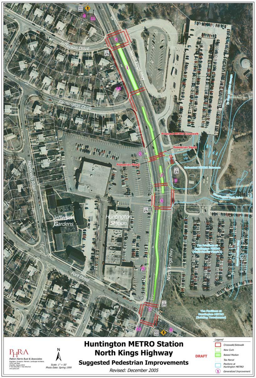
10 METRO Huntington Station Shopping Center Proposed County Pedestrian Crosswalk Source: Fairfax County DPW Existing Conditions at Proposed Crosswalk -10-
11 The road and site plans related to improvements east of North Kings Highway that include new access to the parking areas have been prepared by the developer and have been approved by Fairfax County. The developer intends to start construction in early The first phase of development is multi-family residential building south of Huntington Park Drive (Fairfax County Site Plan #7878-SP-04) at Grand Pavilions Way. No changes to the existing Kiss and Ride access at the Jefferson Drive traffic signal are anticipated. Improvements to increase the parking capacity at the Station include construction of a new garage north east of the existing facility with access to the existing traffic signal to North Kings Highway and access to the north to Huntington Avenue. WMATA anticipates to advertise for bids for the design/build project in the first quarter of With the new garage and the development of the Pavilions at Huntington Metro multi-family uses, the existing METRO access opposite the Huntington Station Shopping center will be improved to provide additional inbound and outbound travel lanes east of North Kings Highway. The construction of Huntington Park Drive will serve as the primary access to the mixed use redevelopment south of the station and provide access to the new METRO garage. As part of the design process for the new METRO infrastructure access, the rezoning plans had been refined to accommodate VDOT and WMATA comments and allow maximum vehicle capacity for egress to North Kings Highway. The improvement plans, as approved, includes signal modifications at the Huntington Park Drive opposite the shopping center and new crosswalks. The improvements create an off-set of the alignment with the Huntington Station Shopping Center. The signal plans propose a split phase operation (i.e., green to exit Huntington Park Drive and green to exit the shopping center) to accommodate the lane shift. Final signal plan modifications at the shopping center entrance and the realigned entrance to the proposed Huntington Park Drive are under final design. Coordination of through access on the east and west side of North King is critical to the success of any pedestrian access plan within this corridor. PEDESTRIAN ACCESS ISSUES Based on our field review of pedestrian activities, the existing road corridor is not designed to promote a pedestrian friendly environment and does not support the County s Comprehensive Plan guidelines to create a Transit Oriented Development (TOD) node. The existing center turn lane of North Kings Highway and the lack of well defined pedestrian access choices do not promote a feeling of safety desirable sense of place, or a streetscape that is inviting to pedestrians. A lack of visible well defined crosswalks on all corners, and pedestrian landings (eg. raised medians), long crossing timings and high speeds on North Kings Highway make pedestrian movements very a low priority in consideration to vehicle movements. -11-
12 PEDESTRIAN PLAN RECOMMENDATIONS The new VDOT Subdivision Street Manual encourages infrastructure design for Neotraditional Neighborhood Design and innovative design proposals which focus on design requirements to support a multi-use, walkable community with moderate to high residential densities and a mixed use core. The design standards identify roadway features for new subdivision streets traffic calming, curb extensions, short block lengths as design features to diffuse traffic and shorten walking distances. The standards also are designed to minimize through traffic and should be employed here and at other METRO zones or areas It is noted, however, in the past these design standards have not typically been associated with an arterial roadway such as North Kings Highway. Given the desire of the County to create new transit oriented development with strong pedestrian elements, it would seem appropriate to consider a policy shift that would encourage application of these standards. With the walking distance at approximately 70 feet, the ability to encourage walk trips across North Kings Highway is limited with right turn lanes, high speeds and limited pedestrian refuge areas at the signals. Designs to promote increased pedestrian access at the street level is vital to the success of the TOD and the safety of existing and future METRO users. The following paragraphs outline specific design elements and recommendations that PHR+A believe could serve to improve accessibility to METRO and pedestrian safety within the corridor. All recommended improvements could be accommodated within the existing rightof-way with the exception of improvement 9 and 10. Attached is an aerial exhibit that delineates the recommendations and a proposed section for North Kings Highway that depicts the lane configuration and median improvements suggested herein. These recommendations are preliminary and should be further evaluated for their feasibility, appropriateness and effectiveness. The improvements are outlined below, including 1. Install a raised median (19 feet wide) on North Kings Highway at Jefferson Drive 2. Install a raised median (7 foot wide) south of Farmington to accommodate left turns lanes 3. Elimination of the existing right turn lane on northbound North Kings Highway to the upper level of the METRO garage and reduce outbound right turn radius exiting Huntington Park Drive to 25 feet. 4. Provide enhance crosswalks at the Jefferson Drive traffic signal with countdown heads. 5. Install new pedestrian Signal at METRO egress (north garage entrance) interconnected to existing signal and provide new crosswalk 6. Adding crosswalks on all quadrants at the existing signal at the shopping center entrance, opposite the new leg of Huntington Park Drive. 7. Realign crosswalk at Fort Drive -12-
13 8. Reduce Speed limit in the Metro zone to 25 MPH with advanced warning signage. Establish a metro zone for the area to promote pedestrian activity. 9. With redevelopment, add on-street parking on southbound North Kings Highway 10. Widen sidewalk adjacent to Farmington intersection and install a 2 foot buffer between the curb and the sidewalk. Add crosswalk north of Farmington 11. Encourage increased traffic calming north of the METRO zone on North Kings Highway in conjunction with I-495/Telegraph Road interchange 12. Add crosswalks south of Fort Drive at midblock location and at Fairhaven Drive. Median The existing roadway cross-section accommodates an ultimate four lane divided arterial roadway cross-section with approximately 70 feet between the face of curb and face of curb. The center turn lane was designed to accommodate a raised 16 foot wide median with 12 foot left turn bays at intersections. The raised median was not installed due to the spacing of driveways and streets adjacent to the METRO station. Installation of a median is suggested to improve pedestrian crossings and enhance streetscape viewsheds, as shown with improvements #1 and #2. To provide adequate space in the median, the travel lanes on North Kings Highway would be reduced to an effective 11 foot width. The reduction in width provides for an effective 19 foot wide median, without turn lanes. The full width median is shown south of Jefferson Drive, since left turns are prohibited with the one-way traffic circulation. South of Farmington Drive, the median width is reduced to 7 feet to accommodate left turns to Farmington Drive and the METRO garage. The median crossover spacing is less than VDOT design standards for a 40 MPH design, but the access is controlled at specific locations, and the provisions of the median should reduce travel speeds and provide a pedestrian sanctuary area for safer crossings. To the south, the raised median would reduce from the 7 foot width to the existing conditions at the Fort Drive signal. The Roadway width at Fort Drive was not designed for a raised median within the existing R-O-W. A raised median is desirable, but the construction impacts to widen the outside curb which would reduce pedestrian areas was not considered practical for initial design. Based on the VDOT median crossover spacing requirements at a 35 MPH design speed (or 10 MPH above the recommended speed, see improvement #8), the distance between median crossovers is a 500 foot minimum feet and 600 feet desirable. As shown below, the intersection spacing does not satisfy the VDOT minimum requirements, so a design exception will be required. However, since the proposed design provides improved pedestrian access without significantly reducing roadway capacity, the crossover -13-
14 spacing waiver could be processed. It is our experience that such a request would require local jurisdiction approval, a detailed traffic analysis and design justification, before VDOT could approve. The existing intersection spacing along North Kings Highway is shown in Table 1 Jefferson Drive/METRO Kiss and Ride entrance Farmington Drive METRO bus entrance * North METRO garage driveway South METRO garage driveway/huntington Station Intersection Crossover OK? Spacing Spacing Farmington Drive 315 ft 315 ft Waiver METRO bus entrance * North METRO garage driveway South METRO garage driveway/huntington Station South retail entrance * ft 210 ft ** 310 ft Waiver 170 ft 170 ft Waiver 280 ft South retail entrance * Fort Drive 255 ft 535 ft OK *Not proposed for median crossover entrance. Distances are approximate ** Assumes a 50 foot shift south per submitted site plans by others The following design exceptions associated with the recommended design will need to be pursued through VDOT with the raised median: Crossover spacing of less than 500 feet, Not providing right turn deceleration lanes, if warranted by peak hour volumes, Reduced left turn storage lengths for NB lefts at Farmington Drive Reduced right turn storage length for NB rights into the second METRO garage entrance Additional design exceptions may be required, subject to additional engineering. Right Turn Lanes The proposed street section envisions a balanced function to reduce walking distances. For suburban development, VDOT typically requires separate right turn lanes to decelerate turns and provide stacking. On Northbound North Kings Highway separate right turn lanes have been constructed at the kiss and ride entrance opposite Jefferson Drive, at the garage entrance
15 and at the existing parking lot entrance at the traffic signal. No separate right turn lanes are provided on the southbound approaches. With the realignment of the METRO access at Huntington Park Drive and the construction of the new Pavilions at Huntington Station development, the right turn lanes are maintained, with the southern right turn lane access at the signal lengthened based on the 40 MPH design speed. To reduce pedestrian distances and provide additional traffic calming, the concept plan suggests reducing the outbound radius to 25 feet for right turns and reducing the storage area into the existing garage, as identified in improvement #3. The traffic signal at the shopping center would remain, with enhancements for a bulb-out in the northeast quadrant to reduce the walking distance with the existing right turn deceleration lane. The reduction in storage length is compensated by the extension of the southern right turn lane, as approved through the County site plan process. The second right turn lane only serves the upper level of the existing parking garage. To reduce speed differential and avoid increased walking distances, separate right turn lanes are not recommended on the southbound approach, if redevelopment occurs. Based on VDOT guidelines, existing and future traffic volumes would warrant the turn lane, but the improvements increase pedestrian safety substantially. Pedestrian Signal Control The plans identify locations for pedestrian crossings at the existing traffic signals and recommendations for additional traffic control at the METRO garage access to promote improved pedestrian access : 1. Jefferson Drive install pedestrian activated crosswalks on all 4 legs of the intersection, especially the south leg with countdown timers, as shown with improvement #4. Boxing the intersection with crosswalks will introduce additional pedestrian capacity and identify the intersection as an entry point to the METRO area. The south leg crossing, with a raised median, also would allow for pedestrian refuge area. 2. North garage access - Based on our review of the County s proposed pedestrian crosswalk north of the garage access, PHR+A would suggest that an additional pedestrian crosswalk be designed with the proposed raised median immediately north of the relocated METRO driveway access. To service the existing demand in a safe manner, the pedestrian crossing should be signal controlled, as shown in improvement #5. This would address County concerns related to safety with the current proposal to add a crosswalk without signal control. We understand that installation of signal control at this location was originally denied by VDOT during the site plan process for the METRO access and the Pavilions at Huntington Metro development, due to the close proximity of two signals on North Kings Highway. The developer elected to redesign the internal street access and install a new signal on Huntington Park Drive north of Kings Highway to regulate traffic flow between the -15-
16 METRO garages and the redevelopment. A pedestrian only signal would require a new mast arm signal pole which would stop traffic on North Kings Highway traffic exiting the garage. The existing shopping center driveway is striped as in-only entrance. The recommended pedestrian signal timing can be set by the cycle length for the new shopping center/huntington Park Drive signal. With the revised entrance configuration which prohibit lefts out of the north METRO garage access, the proposed pedestrian signal can operate as a slave to the existing signal. Stop bars and a signal mast arm to stop through traffic are recommended to ensure that the pedestrian crossing is not executed under yield conditions. Additional signal heads for the outbound METRO traffic to stop before turning right should be considered. 3. Huntington Station/Huntington Park Way METRO signal Provide crosswalks on all 4 quadrants and include a bulb-out in the north corner on the METRO side to reduce walk distances, as shown with improvement #6. Identifying a crosswalk on the west side of the intersection across the shopping center entrance should be prioritized. Redevelopment should include a new entrance without a concrete driveway apron to better distinguish pedestrian areas and realigned with new METRO entrance on Huntington Park Drive. 4. Fort Drive Shorten the crossing length for the north leg, by adding a new handicapped ramp and shifting the crosswalk to be perpendicular to North Kings Highway, shown as improvement #7. Speed Limit Reduction The ultimate success of the pedestrian corridor is dependent on a reduction of travel speeds, consistent with the increase in pedestrian activities. We recommend a 25 MPH speed limit adjacent to the METRO zone, with advanced flashing signs on both the northbound and southbound approaches approaching the study area, as shown with improvement #8. The reduced speed limit would balance the function of the public R-O-W by encouraging pedestrian and vehicle access. This improvement, in our opinion, would provide the most effective traffic calming element in the study area, but will require additional enforcement and VDOT approval. Typically, VDOT does not prefer to have the speeds vary by section, but designation of a METRO zone should allow flexibility. At a minimum, speed reductions during roadway periods with heavy commuter and pedestrian access could be considered. On-Street Parking with Redevelopment West of North Kings Highway The proposed roadway cross-section envisioned maintained the existing outside curb location in the study area. However, with the potential redevelopment of the Huntington Station site, the opportunity to add on-street parking while maintaining the four lane section of North -16-
17 Kings Highway should be considered, as shown as improvement #9. The addition of a parking lane would require additional R-O-W and could be considered with redevelopment, if VDOT approves the widening. The location of on-street parking should be designed for the mid block areas and should not reduce pedestrian crossing lengths at the existing and proposed signals. The parking lane would require an additional 8 foot wide of infrastructure improvements, including relocating utilities and providing a new pedestrian facility behind the new curb. Enhanced Pedestrian Crosswalks The design of the crosswalks is shown to minimum VDOT standards with a 10 foot wide painted crosswalk. Due to the enhanced pedestrian activities and access to the METRO area, options to include stamped asphalt patterns or raised crosswalks should be considered to provide traffic calming and clearly identify pedestrian activities in the area. Any improvement should included upgraded pedestrian landings to accommodate current ADA requirements at the ramps, as well as support signing for pedestrians. At a minimum, the ladder or high visibility crosswalks should be installed at all approaches, including crossing the side streets at Farmington Drive to establish a pedestrian zone. West Sidewalk Subject to coordination with adjacent property owners, the opportunity to shift the sidewalk on the west side of Route 241 away from the existing travel lanes improves pedestrian usability. Currently, the 4 foot walk is located behind the back of curb. As shown in improvement #10, the opportunity of shifting the sidewalk and adding a 2 foot buffer area (with 5 foot walk) could be accomplished with revised grading to the properties and construction of a low retaining wall. Other Corridor Improvements Identifying traffic calming measures north of the METRO access could be considered, especially with the programmed interchange improvements at Telegraph Road and the Capital Beltway. Under the proposed reconstruction, the Jefferson Drive signal is the first stop location in the Kings Highway corridor. Identification of roadway transition is accomplished with the grade uphill, but the pedestrian access to the north adjacent to the new interchange may be a future phase of study, as improvement #11. South of Fort Drive, the four lane undivided section of North Kings Highway may be considered for improved signing and crosswalks at the existing bus stop and to cross North Kings Highway at the raised median at Fairhaven Drive. Pedestrian signage and crosswalks are suggested with improvement #12. The area is adjacent to individual residential houses with driveways on Route 241, but no pedestrian facilities to cross are provided. -17-
18 METRO ZONES If the plan achieves support from the stakeholders, PHR+A recommends that the County consider creating a METRO zone in the area of the existing station in order to focus on public improvements that address pedestrian access. The opportunity to prioritize pedestrian design in high volume traffic areas at the METRO station and with Transit Oriented Development could allow VDOT to better coordinate their design standards with the goals for increased mobility associated with the County s Comprehensive Plan. With the pedestrian enhancements goals defined through a METRO zone, the County should examine funding options through public and private sectors to establish potential timelines for improvements, as well as provide a general blue print of potential corridor improvements to be considered in the updates of the land use and transportation plans of the vicinity. -18-
19 -19-
20 -20-
5. RUNNINGWAY GUIDELINES
 5. RUNNINGWAY GUIDELINES These guidelines should be considered collectively when making runningway decisions. A runningway is the linear component of the transit system that forms the right-of-way reserved
Summary: Mercer County Princeton Avenue & Spruce Street Study January 2009
 Summary: Several recent studies have assessed potential development and redevelopment opportunities in the Mercer Crossing area of Trenton, Ewing, and Lawrence. This Princeton Avenue and Spruce Street
Appendix C. NORTH METRO STATION AREA TRAFFIC IMPACT STATEMENT 88th Avenue Station
 Appendix C NORTH METRO STATION AREA TRAFFIC IMPACT STATEMENT 88th Avenue Station Prepared for: Regional Transportation Department and URS Corporation as part of the North Metro EIS David Evans and Associates,
DEPARTMENT OF ENVIRONMENTAL SERVICES. North Harrison Street (Lee Highway to Little Falls Road) Comparative Analysis. Prepared for:
 Comparative Analysis. Prepared for:") DEPARTMENT OF ENVIRONMENTAL SERVICES North Harrison Street (Lee Highway to Little Falls Road) Comparative Analysis Prepared for: Arlington County Department of Environmental Services 2100 Clarendon Boulevard,
DEPARTMENT OF ENVIRONMENTAL SERVICES North Harrison Street (Lee Highway to Little Falls Road) Comparative Analysis Prepared for: Arlington County Department of Environmental Services 2100 Clarendon Boulevard,
COWETA HIGH SCHOOL AND EAST HIGHWAY 51
 COWETA HIGH SCHOOL AND EAST HIGHWAY 51 Lack of sidewalks along Ben Lumpkin Rd. Lack of crosswalks and ramps at intersection. Hwy 51 is wide to cross as a pedestrian. No ADA compliance or connection to
Transportation Corridor Studies: Summary of Recommendations
 Transportation Corridor Studies: Summary of Recommendations Route 4 Corridor Study: Route 10 Corridor Study: Route 44 Corridor Study: Route 175 Corridor Study: Route 5/15 Corridor Study: Rentschler Field
Orange Center Elementary School
 Drag and drop pic and stretch/crop to the limits of the blue rectangle (delete this text box) Orange Center Elementary School Drag and drop pic and stretch/crop to the limits of the blue rectangle (delete
TRAFFIC ACTION PLAN. Laurie Meadows Neighborhood CITY OF SAN MATEO
 TRAFFIC ACTION PLAN Laurie Meadows Neighborhood CITY OF SAN MATEO Draft January 2017 Table of Contents Introduction... 2 The Traffic Forum Process... 5 Neighborhood Traffic Issues... 7 Neighborhood Recommendations
M-58 HIGHWAY ACCESS MANAGEMENT STUDY Mullen Road to Bel-Ray Boulevard. Prepared for CITY OF BELTON. May 2016
 M-58 HIGHWAY ACCESS MANAGEMENT STUDY Prepared for CITY OF BELTON By May 2016 Introduction Missouri State Highway 58 (M-58 Highway) is a major commercial corridor in the City of Belton. As development has
Agenda. Overview PRINCE GEORGE S PLAZA METRO AREA PEDESTRIAN PLAN
 PRINCE GEORGE S PLAZA METRO AREA PEDESTRIAN PLAN May 28, 2008 Agenda Welcome and introductions Project overview and issue identification Planning context and strengths Design challenges and initial recommendations
Small Area Study U.S. Route 220 and VA Route 615 Intersection. Bath County, Virginia
 Small Area Study U.S. Route 220 and VA Route 615 Intersection Bath County, Virginia Prepared by the Central Shenandoah Planning District Commission Final Report February 2018 Table of Contents 1. INTRODUCTION...
Shockoe Bottom Preliminary Traffic and Parking Analysis
 Shockoe Bottom Preliminary Traffic and Parking Analysis Richmond, Virginia August 14, 2013 Prepared For City of Richmond Department of Public Works Prepared By 1001 Boulders Pkwy Suite 300, Richmond, VA
C C C
 C-012-001 Thank you for your support for the creation of new public space and nonmotorized access between downtown and the waterfront through the Overlook Walk, the East-West Connections, and the Promenade.
Appendix 3 Roadway and Bike/Ped Design Standards
 Appendix 3 Roadway and Bike/Ped Design Standards OTO Transportation Plan 2040 4/20/2017 Page A3-1 Adopted Standards The adopted OTO Design Standards and Major Thoroughfare Plan are contained herein.
Glenn Avenue Corridor Traffic Operational Evaluation
 Glenn Avenue Corridor Traffic Operational Evaluation PREPARED FOR: THE CITY OF AUBURN PREPARED BY: DECEMBER 2007 Glenn Avenue Corridor Study--Auburn, Alabama TABLE OF CONTENTS Introduction... 1 Background
S T A T I O N A R E A P L A N
 The Circulation and Access Plan describes vehicle, pedestrian, and transit improvements recommended within the Concept Plan. In order to create and sustain a vibrant business district that provides pedestrian-friendly
Comments EXECUTIVE SUMMARY
 Comments 1. Under any Alternatives, MCDOT should provide better at-grade pedestrian crossing of Georgia Avenue and Forest Glen Road, including improved crosswalks with wider medians and adequate signal
Route 7 Corridor Study
 Route 7 Corridor Study Executive Summary Study Area The following report analyzes a segment of the Virginia State Route 7 corridor. The corridor study area, spanning over 5 miles in length, is a multi
City of Wayzata Comprehensive Plan 2030 Transportation Chapter: Appendix A
 A1. Functional Classification Table A-1 illustrates the Metropolitan Council s detailed criteria established for the functional classification of roadways within the Twin Cities Metropolitan Area. Table
Roadway Classification Design Standards and Policies. Pueblo, Colorado November, 2004
 Roadway Classification Design Standards and Policies Pueblo, Colorado November, 2004 Table of Contents Page Chapter 1. General Provisions 1.1 Jurisdiction 3 1.2 Purpose and Intent 3 1.3 Modification 3
Transportation Impact Study for Abington Terrace
 Transportation Impact Study for Abington Terrace Abington Township, Montgomery County, PA Sandy A. Koza, P.E., PTOE PA PE License Number PE059911 Prepared by McMahon Associates, Inc. 425 Commerce Drive,
Report. Typical Sections. City of Middleton, WI
 Report Typical Sections City of Middleton, WI December 2006 Report for City of Middleton, Wisconsin Typical Sections repared by: Traffic Associates LLC and STRAND ASSOCIATES, INC. 910 West Wingra Drive
PROPOSED BICYCLE AND PEDESTRIAN FACILITY Vicinity of Route 123/I-495 Interchange Tysons, Fairfax County, Virginia
 PROPOSED BICYCLE AND PEDESTRIAN FACILITY Vicinity of Route 123/I-495 Interchange Tysons, Fairfax County, Virginia PRELIMINARY ENGINEERING REPORT Prepared for: Prepared by: July 2017 Table of Contents 1
Chapter 4 Traffic Analysis
 Chapter 4 Traffic Analysis PURPOSE The traffic analysis component of the K-68 Corridor Management Plan incorporates information on the existing transportation network, such as traffic volumes and intersection
Access Location, Spacing, Turn Lanes, and Medians
 Design Manual Chapter 5 - Roadway Design 5L - Access Management 5L-3 Access Location, Spacing, Turn Lanes, and Medians This section addresses access location, spacing, turn lane and median needs, including
TRAFFIC IMPACT ANALYSIS
 TRAFFIC IMPACT ANALYSIS FOR THE CHAMPAIGN UNIT#4 SCHOOL DISTRICT PROPOSED HIGH SCHOOL (SPALDING PARK SITE) IN THE CITY OF CHAMPAIGN Final Report Champaign Urbana Urbanized Area Transportation Study 6/24/2014
Los Altos Hills Town Council - June 18, 2015 Palo Alto City Council June 22, AGENDA ITEM #2.B Presentation
 Los Altos Hills Town Council - June 18, 2015 Palo Alto City Council June 22, 2015 AGENDA ITEM #2.B Presentation Previous Presentations Los Altos Hills Town Council in May 2014 and February 2015 Palo Alto
Project Description Form 8EE
 Project Description Form 8EE Basic Project Information Submitting Jurisdiction/Agency: Town of Dumfries Project Title: Route 1 (Fraley Blvd) Widening: Brady's Hill Road to Dumfries Road Project Location:
Corridor Recommendations and Implementation
 Corridor Recommendations and Implementation INTER-PARCEL CONNECTIVITY Both alternative Concept A and Concept B segments of the Community Core suggest a system of interconnected local streets and local
CITY OF WEST LAKE HILLS. Forest View Neighborhood Traffic Calming Study
 CITY OF WEST LAKE HILLS 901 South Mopac Expressway Building V, Suite 220 Austin, Texas 78746 Texas P.E. Firm Registration No. F-929 Klotz Associates Final Report Submittal: March 20, 2015 Revised Final
Chapter 5 Future Transportation
 Chapter 5 Future Transportation The Future Land Use Plan identifies the desired land use designations. The land uses desired for Crozet depend, in large part, on the success of the transportation system,
Road Diets FDOT Process
 Florida Department of TRANSPORTATION Road Diets FDOT Process Humberto Castillero, PE, PTOE Roadway Design Office Purpose of Guide Develop a statewide lane elimination review process Balance state & local
Design Criteria. Design Criteria
 F Design Criteria Design Criteria Ministry of Transportation Ministère des Transports DESIGN CRITERIA Page: 1 of 13 WORK PROJECT NO. N/A GO Bloomington Station TYPE OF PROJECT LOCATION Bloomington Road
Long Island Rail Road Expansion Project Floral Park to Hicksville
 Long Island Rail Road Expansion Project Floral Park to Hicksville Final Environmental Impact Statement Appendix 1-D Complete Streets Policy Checklist April 2017 0902ML PIN: Project Location: 18A-4 Floral
CITY OF OTTAWA ROADWAY MODIFICATION APPROVAL UNDER DELEGATED AUTHORITY
 RMA-2015-ATM-038 CITY OF OTTAWA ROADWAY MODIFICATION APPROVAL UNDER DELEGATED AUTHORITY DATE: April 22, 2015 SUBJECT Approval of Roadway Modifications Recommended through an Area Traffic Management Study
Meadow Woods Elementary School
 Drag and drop pic and stretch/crop to the limits of the blue rectangle (delete this text box) Meadow Woods Elementary School Drag and drop pic and stretch/crop to the limits of the blue rectangle (delete
TRAFFIC IMPACT STUDY CRITERIA
 Chapter 6 - TRAFFIC IMPACT STUDY CRITERIA 6.1 GENERAL PROVISIONS 6.1.1. Purpose: The purpose of this document is to outline a standard format for preparing a traffic impact study in the City of Steamboat
4. ENVIRONMENTAL IMPACT ANALYSIS 9. TRANSPORTATION AND TRAFFIC
 4. ENVIRONMENTAL IMPACT ANALYSIS 9. TRANSPORTATION AND TRAFFIC 4.9.1 INTRODUCTION The following section addresses the Proposed Project s impact on transportation and traffic based on the Traffic Study
Hidden Oaks Elementary School
 Hidden Oaks Elementary School SCHOOL ROUTE PLAN For HIDDEN OAKS ELEMENTARY SCHOOL LOCATION 13 ORANGE COUNTY Prepared for: ORANGE COUNTY SCHOOL ASSESSMENT PROGRAM ORANGE COUNTY PUBLIC WORKS Traffic Engineering
MAG Town of Cave Creek Bike Study Task 6 Executive Summary and Regional Significance Report
 Page 1 MAG Town of Cave Creek Bike Study Task 6 Executive Summary and Regional Significance Report August 1, 2012 MAG Project #481 Page 2 Task 6 Executive Summary and Regional Significance Report Introduction
Water Street Promenade Engineering and Design Services
 Preliminary Design Presentation Parking & Traffic Safety Committee Water Street Promenade Engineering and Design Services July 16,2014 November 3, 2016 Education / Infrastructure / Innovation 1 Project
Vision: Traditional hamlet with an attractive business/pedestrian friendly main street connected to adjacent walkable neighborhoods
 N D. Focus Area II Vision: Traditional hamlet with an attractive business/pedestrian friendly main street connected to adjacent walkable neighborhoods Transit Road Focus Area II is located in the Hamlet
Donahue Drive Corridor Traffic Operational Evaluation
 Donahue Drive Corridor Traffic Operational Evaluation PREPARED FOR: THE CITY OF AUBURN PREPARED BY: JANUARY 2007 Donahue Drive Corridor Study--Auburn, Alabama TABLE OF CONTENTS Introduction... 1 Background
Memorandum. Sunday, July 13, Saturday, July 19, 2014
 Memorandum To: David Lowin, Brooklyn Bridge Park Corporation From: Daniel Schack, AICP, PTP Date: Re: Brooklyn Bridge Park Pier 5/6 Loop Road Traffic Study Project No: 14-01-2407 At the request of Brooklyn
ROUTE 81 CORRIDOR STUDY DESIGN CONCEPTS
 RT 81 Corridor Study CLINTON ROUTE 81 CORRIDOR STUDY DESIGN CONCEPTS View north on High Street, with potential improvements to the streetscape Draft Recommendations November 8 th, 2018 TOWN OF CLINTON
Figure 4-10: Pedestrian Improvements Types of Potential Station Area Improvements - Place-Making Improvements
 INCORPORATE FEATURE PAVIN IN CROSSWALK AND INTERSECTION FIELDS Identifies high-priority pedestrian areas and create a station identity through colorful and interesting patterns ADD CURB EXTENSIONS Extending
Roundabouts are good for business
 Roundabouts are good for business What is a roundabout Rules 0f Roundabouts 1. Slow down when approaching a roundabout 2. Yield to vehicles in the roundabout 3. When clear, proceed right into the roundabout
Broad Street Bicycle Boulevard Design Guidelines
 Broad Street Bicycle Boulevard Design Guidelines Building from the strategies introduced in the 2013 Bicycle Transportation Plan and community input received thus far, City Transportation Staff have identified
Approximately 360 trail users cross during a typical summer weekday and 420 cross during a typical summer
 5. PARKR ROAD AT MISSISSIPPI AVN CROSSIN xisting Conditions The High ine Canal trail crosses Parker Road near the Mississippi Avenue intersection (crossing location #3 on Figure 1). South of Parker, the
5 CIRCULATION AND STREET DESIGN
 5 CIRCULATION AND STREET DESIGN This chapter describes circulation and streetscape improvements proposed for the Northwest Chico Specific Plan Area. It includes detailed design specifications for existing
Access Management in the Vicinity of Intersections
 Access Management in the Vicinity of Intersections FHWA-SA-10-002 Technical Summary Photo: Ralph Bentley (used with permission) 0 Access Management is: The design, implementation and management of entry
Washington St. Corridor Study
 FIGURE 7.17 Bridge Alternatives - Cross Sections 86 Discarded Alternative: Short-Term Bridge Repair Short-term repairs and west bridge span replacement were considered during analysis. Short-term repairs
Traffic Impact Analysis Walton Acres at Riverwood Athletic Club Clayton, NC
 Traffic Impact Analysis Walton Acres at Riverwood Athletic Club Clayton, NC 1. TABLE OF CONTENTS INTRODUCTION...1 1.1. Site Location and Study Area...1 1.2. Proposed Land Use and Site Access...2 1.3.
Classification Criteria
 SCHEDULE D TO RECOMMENDED OFFICIAL PLAN AMENDMENT NO. 40 SCHEDULE C-4 Road Criteria Criteria Traffic Service Objective Land Service/Access Typical Daily Traffic Volume Flow characteristics Travel Speed
Chapter 2: Standards for Access, Non-Motorized, and Transit
 Standards for Access, Non-Motorized, and Transit Chapter 2: Standards for Access, Non-Motorized, and Transit The Washtenaw County Access Management Plan was developed based on the analysis of existing
Item to be Addressed Checklist Consideration YES NO N/A Required Description Complete Streets Guidelines
 Passaic County Complete Streets Checklist - Concept Development Project Name Item to be Addressed Checklist Consideration YES NO N/A Required Description Complete Streets Guidelines Existing Plans Have
LSC TRANSPORTATION CONSULTANTS, INC. 516 North Tejon Street Colorado Springs, CO (719) FAX (719)
 FAX (719)") LSC TRANSPORTATION CONSULTANTS, INC. 516 North Tejon Street Colorado Springs, CO 80903 (719) 633-2868 FAX (719) 633-5430 E-mail: lsc@lsccs.com May 15, 2009 Mr. Davis Farrar Western Slope Consulting, LLC
LSC TRANSPORTATION CONSULTANTS, INC. 516 North Tejon Street Colorado Springs, CO 80903 (719) 633-2868 FAX (719) 633-5430 E-mail: lsc@lsccs.com May 15, 2009 Mr. Davis Farrar Western Slope Consulting, LLC
Traffic Impact Analysis Chatham County Grocery Chatham County, NC
 Chatham County Grocery Chatham County, NC TABLE OF CONTENTS 1. INTRODUCTION... 1 1.1. Location and Study Area... 1 1.2. Proposed Land Use and Access... 2 1.3. Adjacent Land Uses... 2 1.4. Existing ways...
Forest Hills Improvement Initiative
 Forest Hills Improvement Initiative Transportation Action Plan Short Term Recommendations ONLY Final Draft as of April 30, 2008 For Community Review and Feedback Prepared for: The City of Boston Boston
This page intentionally left blank.
 This page intentionally left blank. COMMUNITY Coweta Community Overview Coweta Coweta, a residential community located in Wagoner County, is a suburb of Tulsa situated southeast of the metropolitan area
Executive Summary Route 30 Corridor Master Plan
 Route Corridor Master Plan Project Overview The Route Corridor Master Plan is a coordinated multimodal transportation and land use plan for the entire stretch of Route through East Whiteland Township,
BETHEL ROAD AND SEDGWICK ROAD CORRIDOR STUDY
 DRAFT PLAN City Council Meeting August 14, 2017 STUDY AREA Sedgwick Corridor State Route 160, principal arterial with Class 3 access management designation, commuter and freight route, connection to SR
TOWN OF CHAPEL HILL POLICY AND PROCEDURES FOR TRAFFIC CALMING MEASURES
 TOWN OF CHAPEL HILL POLICY AND PROCEDURES FOR TRAFFIC CALMING MEASURES (Adopted by the Town Council on June 30, 2004) (Revised December 6, 2010) (Revised February 8, 2016) POLICY AND PROCEDURES FOR TRAFFIC
CITY MANUALS AND STANDARDS REVIEW
 GEORGETOWN SIDEWALK MASTER PLAN CITY MANUALS AND STANDARDS REVIEW RESOURCES AND STANDARDS As part of the Master Plan process, a review and evaluation of current City documents and policies relevant to
Traffic Impact Study for Rolling Ridge Redevelopment
 Traffic Impact Study for Rolling Ridge Redevelopment Webster Groves, Missouri October 19, 2018 Prepared For: Gershman Commercial Real Estate 150 North Meramec Avenue Suite 500 St. Louis, Missouri 63105
St. Francis Drive through the City of Santa Fe Corridor Study
 VII. ENGINEERING AND ENVIRONMENTAL EVALUATION TRAIL CONNECTIVITY In the southern portion of the Corridor there is a lack of a sidewalk, trail or bicycle facility within the right-ofway. However, the City
City of Gainesville Transportation/Roadway Needs PROJECT SUMMARY
 A1 Roadway Resurfacing $23,846,000 TYPE: Preservation of existing system Roadway resurfacing A2 Signal Replacement $6,000,000 TYPE: Preservation of existing system Replace traffic signals. B1 W 6th St
Monroe Street Reconstruction
 Total participants: 45+ Monroe Street Reconstruction Cross Section Workshop Notes September 29, 2016, Wingra School Workshop Orientation, Technical and Functional Considerations: The workshop began with
OTTAWA TRAIN YARDS PHASE 3 DEVELOPMENT CITY OF OTTAWA TRANSPORTATION IMPACT STUDY. Prepared for:
 OTTAWA TRAIN YARDS PHASE 3 DEVELOPMENT CITY OF OTTAWA TRANSPORTATION IMPACT STUDY Prepared for: The Ottawa Train Yards Inc. 223 Colonnade Road South, Suite 212 Nepean, Ontario K2E 7K3 January 17, 2012
1 st and 2 nd Street Couplet FAQ s
 1 st and 2 nd Street Couplet FAQ s Q. Will the proposed roundabout at Flume/2nd/1 st Streets affect access to businesses nearby?... 2 Q. What if the project isn t received well by the community after construction?...
Truck Climbing Lane Traffic Justification Report
 ROUTE 7 (HARRY BYRD HIGHWAY) WESTBOUND FROM WEST MARKET STREET TO ROUTE 9 (CHARLES TOWN PIKE) Truck Climbing Lane Traffic Justification Report Project No. 6007-053-133, P 101 Ι UPC No. 58599 Prepared by:
Giles Run Connector Road
 Giles Run Connector Road Laurel Hill Adaptive Reuse Area to Laurel Crest Drive South County Federation Meeting June 14, 2016 History Connector road included in the Laurel Hill Comprehensive Plan amendment
Southwest Bus Rapid Transit (SW BRT) Functional Planning Study - Executive Summary January 19 LPT ATTACHMENT 2.
 Functional Planning Study - Executive Summary January 19 LPT ATTACHMENT 2.") Southwest Bus Rapid Transit (SW BRT) Functional Planning Study - Executive Summary 2011 January 19 1 of 19 Introduction This executive summary presents the results of the Southwest Bus Rapid Transit (SW
Southwest Bus Rapid Transit (SW BRT) Functional Planning Study - Executive Summary 2011 January 19 1 of 19 Introduction This executive summary presents the results of the Southwest Bus Rapid Transit (SW
Circulation in Elk Grove includes: Motor vehicles, including cars and trucks
 Circulation, as it is used in this General Plan, refers to the many ways people and goods move from place to place in Elk Grove and the region. Circulation in Elk Grove includes: Motor vehicles, including
METHODOLOGY. Signalized Intersection Average Control Delay (sec/veh)
") Chapter 5 Traffic Analysis 5.1 SUMMARY US /West 6 th Street assumes a unique role in the Lawrence Douglas County transportation system. This principal arterial street currently conveys commuter traffic
Chapter 5 Traffic Analysis 5.1 SUMMARY US /West 6 th Street assumes a unique role in the Lawrence Douglas County transportation system. This principal arterial street currently conveys commuter traffic
FY STATEWIDE TRANSPORTATION IMPROVEMENT PROGRAM New Jersey Department of Transportation Projects
 ROUTE/ Project ID No. TIP No. Electrical Load Center Replacement - North 04324 04324 This project will provide for the betterment of the existing highway lighting facilities located along Routes 3, 17
Paul Huston, P.E., Design-Build Coordinator Chuck Gonderinger, HDR Engineering. Minnesota Department of Transportation (the Department)
") To: From: Paul Huston, P.E., Design-Build Coordinator Chuck Gonderinger, HDR Engineering Date: March 20, 2001 Subject: Roadway Geometric Design Criteria Project: TH 14/218 Design-Build Project, SP 7408-29,
To: From: Paul Huston, P.E., Design-Build Coordinator Chuck Gonderinger, HDR Engineering Date: March 20, 2001 Subject: Roadway Geometric Design Criteria Project: TH 14/218 Design-Build Project, SP 7408-29,
ARLINGTON COUNTY, VIRGINIA
 ARLINGTON COUNTY, VIRGINIA County Board Agenda Item Meeting of October 15, 2016 DATE: October 7, 2016 SUBJECT: Adoption of amendments to the Master Transportation Plan (MTP) to create a new Pedestrian
Americans with Disabilities Act Transition Plan for Public Right-of-Way Improvements
 Americans with Disabilities Act Transition Plan for Public Right-of-Way Improvements Prepared by: Public Works Department Engineering Division October 2015 Table of Contents Section I Introduction.. 3
10.0 CURB EXTENSIONS GUIDELINE
 10.0 CURB EXTENSIONS GUIDELINE Road Engineering Design Guidelines Version 1.0 March 2017 City of Toronto, Transportation Services City of Toronto Page 0 Background In early 2014, Transportation Services
Tonight is for you. Learn everything you can. Share all your ideas.
 Strathcona Neighbourhood Renewal Draft Concept Design Tonight is for you. Learn everything you can. Share all your ideas. What is Neighbourhood Renewal? Creating a design with you for your neighbourhood.
SPRINGFIELD REVITALIZATION REPORT
 SPRINGFIELD REVITALIZATION REPORT August 2015 Homewood Suites Springfield Town Center Promenade 2 SPRINGFIELD OVERVIEW This report covers recent development activity in the Springfield Commercial Revitalization
Bay to Bay Boulevard Complete Streets Project
 Bay to Bay Boulevard Complete Streets Project Dale Mabry Highway to Bayshore Boulevard February 08, 2018 Photo Source: Tampa Bay Times Alessandra Da Pra Meeting Format Introduction Resurfacing Information
DRAFT. Corridor study. Honeysuckle Road. October Prepared for the City of Dothan, AL. Prepared by Gresham, Smith and Partners
 DRAFT Corridor study Honeysuckle Road October 2017 Prepared for the City of Dothan, AL Prepared by TABLE OF CONTENTS SECTION I... 1 STUDY SUMMARY... 1 INTRODUCTION... 1 CONCLUSIONS... 5 SECTION II... 7
Active Transportation Facility Glossary
 Active Transportation Facility Glossary This document defines different active transportation facilities and suggests appropriate corridor types. Click on a facility type to jump to its definition. Bike
Legislative Update Williamsburg Residency
 Hampton Roads District Legislative Update Williamsburg Residency Jim Brewer, Resident Administrator 757-253-5140 Projects Under Way Warwick Boulevard Project http://www.warwickboulevard.org/ Contractors:
Intersection Traffic Control Feasibility Study
 Intersection Traffic Control Feasibility Study CSAH 9 at CSAH 60 (185th Avenue) Prepared For: Dakota County Transportation Department Western Service Center 14955 Galaxie Avenue, 3rd Floor Apple Valley,
#!! "$% ##! &! # '#! % $ #!
 Executive Summary US Highway 16 (US 16) is the primary corridor connecting Rapid City to the Black Hills region. It serves a growing population of commercial and residential traffic, as well as seasonal
City of Albert Lea Policy and Procedure Manual 4.10 ALBERT LEA CROSSWALK POLICY
 4.10 ALBERT LEA CROSSWALK POLICY PURPOSE: Pedestrian crosswalks are an integral part of our transportation infrastructure. To be effective and promote safety, marked crosswalks must be installed after
INDUSTRIAL BUILDING 1660 COMSTOCK ROAD CITY OF OTTAWA TRANSPORTATION OVERVIEW. Prepared for:
 INDUSTRIAL BUILDING 1660 COMSTOCK ROAD CITY OF OTTAWA TRANSPORTATION OVERVIEW Prepared for: Simluc Contractors Limited 2550 Blackwell Street, Ottawa K1B 5R1 October 18, 2013 113-584 Overview_1.doc D. J.
ADA Transition Plan. City of Gainesville FY19-FY28. Date: November 5, Prepared by: City Of Gainesville Department of Mobility
 ADA Transition Plan FY19-FY28 Date: November 5, 2018 Prepared by: City Of Gainesville Department of Mobility 1.0 INTRODUCTION 1.1 BACKGROUND The federal statute known as the Americans with Disabilities
Corporate. Report COUNCIL DATE: May 25, 1998 NO: R1500 REGULAR COUNCIL. TO: Mayor & Council DATE: April 27, 1998
 R1500 : Traffic Safety at 25 Avenue and 128 Street Intersection Corporate NO: R1500 Report COUNCIL DATE: May 25, 1998 REGULAR COUNCIL TO: Mayor & Council DATE: April 27, 1998 FROM: General Manager, Engineering
COMMUNITY MEETING AGENDA
 COMMUNITY MEETING AGENDA Welcome and Introductions SAFE Presentation Project Presentation Priorities Feedback Next Steps Q&A Santa Cruz Avenue Corridor Study 1 Santa Cruz Avenue Corridor Study Community
TRAFFIC ACTION PLAN. North Central Neighborhood CITY OF SAN MATEO
 TRAFFIC ACTION PLAN North Central Neighborhood CITY OF SAN MATEO Draft February 2017 Table of Contents Introduction... 1 The Traffic Forum Process... 4 Neighborhood Traffic Issues... 6 Neighborhood Recommendations
Harrah s Station Square Casino
 Transportation Analysis Harrah s Station Square Casino Pittsburgh, Pennsylvania Submitted To: City of Pittsburgh and Pennsylvania Gaming Control Board Prepared By: DKS Associates GAI Consultants December
TRASBURG RANSPORTATION
 TRASBURG RANSPORTATION LAN DEVELOPED BY THE TRANSPORTATION PLANNING DIVISION OF THE VIRGINIA DEPARTMENT OF TRANSPORTATION IN COOPERATION WITH THE U.S. DEPARTMENT OF TRANSPORTATION, FEDERAL HIGHWAY ADMINISTRATION
FI-2 I-66 Between Route 29, Lee Highway and Route 15, James Madison Highway
 TRANSPORTATION PLAN INTENT Transportation is the key to the economic and social development of Prince William County and especially to the I 66/Route 29 Sector Plan area. This includes transportation for
INTRODUCTION THOROUGHFARE SYSTEM CLASSIFICATIONS
 INTRODUCTION The thoroughfare plan will assist public officials in the development of a specialized system for efficient and safe movement of vehicular traffic while minimizing potential conflicts with
ALLEY 24 TRAFFIC STUDY
 ALLEY 24 TRAFFIC STUDY in City of Frostburg, Maryland January 2013 3566 Teays Valley Road Hurricane, WV Office: (304) 397-5508 www.denniscorporation.com Alley 24 Traffic Study January 2013 Frostburg, Maryland
Recommended Roadway Plan Section 2 - Land Development and Roadway Access
 Recommended Roadway Plan Section 2 - Land Development and Roadway Access SECTION 2 Land Development and Roadway Access 2.1 Land Use and Access Management The Federal Highway Administration (FHWA) defines