December For more information, call the Area 2 Division at (301)
|
|
|
- Gordon Robertson
- 5 years ago
- Views:
Transcription
1 December 2013 Appendix B: Transportation Analysis For more information, call the Area 2 Division at (301)
2 GLENMONT SECTOR PLAN TRANSPORTATION APPENDIX November 8,
3 Contents Purpose Transportation Plan Recommendations Transit System Street Network Bicycle and Pedestrian Systems Transportation Land Use Balance Measures of Effectiveness Policy Area Mobility Review (PAMR) Transportation Policy Area Review (TPAR) Local Area Transportation Review (LATR) Cordon Line Analysis Travel Demand Forecasting Process and Assumptions Local Area Modeling Process and Assumptions 2
4 PURPOSE The Plan s vision and the proposed level of future growth are supported by Metrorail, future Bus Rapid Transit (BRT), local bus service, and a network of major and local streets that connect Glenmont neighborhoods to services and amenities within Glenmont and to the region at large. The overall transportation approach consists of the following key elements: High quality transit service; Expanded network of walkable streets; and Improved bicycle and pedestrian connections throughout the Glenmont area. TRANSIT SYSTEM Metrorail The number of passengers boarding trains at Glenmont has increase about 3.5 percent per year since the station opened in In 2011, approximately 5,850 riders boarded trains at Glenmont on an average weekday, a 42 percent increase over the 4,096 average boardings in 1999, the first full year of operation for the Glenmont Metro Station. Compared to other stations, however, Glenmont s ridership is not high. Glenmont serves fewer boarders than all but one of Metro s end of line stations in the region. Within the County, Glenmont s average weekday boardings in 2011 ranked 7 th out of 12. The new parking garage on the west side of Georgia Avenue is expected to increase ridership. WMATA Metro Station Access Study The Washington Metropolitan Area Transit Authority (WMATA) has investigated additional below grade station access points. This Plan does not recommend any specific additional station access points. However, as Glenmont redevelops additional access points may prove beneficial for pedestrian access and safety. Since Glenmont is an end of the line station, it has a high percentage of riders who drive to the Metrorail station. According to the 2007 Metrorail Passenger Survey by WMATA, approximately 50 percent of passengers drove to the station and parked in the garage. An additional 18 percent of the total weekday riders used the Kiss-&-Ride area. About 20 percent arrived via Metro or Ride-On buses and another 13 percent arrived by walking or biking to the station. There are two station entrances one on the east side and another on the west side of Georgia Avenue. A recent WMATA field review of the utilization of each entrance indicates that during the peak periods, 70 percent of those walking to the station used the entrance on the east side of Georgia Avenue. 3
5 Metrobus As stated earlier, about 20 percent of Metro passengers arrive via bus (either Metrobus or Ride-On). The Glenmont Metro Station has a significant amount of bus service, with a total of 11 Metrobus and Ride-On routes serving the station. The Glenmont Metro Station has a bus loop on the east side of Georgia Avenue that accommodates nine (9) Montgomery County Ride-on buses and two (2) WMATA Metro buses (Table 1). There are two (2) additional bus drop-off locations located on Georgia Avenue adjacent to the bus loop. Table 1: Glenmont Bus Routes Route Peak Period Frequency (Min.) Peak Period Service Only Daily Ridership (2011) Major ways Served Ride On Routes Ride On No 2,252 Randolph /Columbia Pike/New Hampshire Ave Ride On No 3,181 Layhill Rd/Georgetown Pike/Aspen Hill Rd. Ride On Yes 116 Georgia Avenue/Randolph Rd./Kemp Mill Rd Ride On Yes 341 Georgia Ave/Kensington Pkwy Ride On Yes 223 Layhill Rd/Bonifant/Briggs Chaney Ride On No 677 Georgia Ave/Connecticut Avenue Ride On No 2,210 Layhill Rd/Norbeck Rd/Bel Pre Rd Ride On Yes 267 Georgia Ave/Layhill Rd/Norbeck Rd Ride On Yes 292 Georgia Ave/Redland Rd/Bowie Mill Rd Metrobus Routes Y5, Y7, Y8, Y No 6,819 Georgia Avenue C No 2,200 Randolph Rd/New Hampshire Rd In a typical weekday, on average, 34 buses depart the Glenmont Metro station during the peak hours, and approximately 285 Metrobus passengers and 573 Ride-On passengers transfer to Metro. 439 passengers leave the station and transfer to Metrobuses and another 871 transfer to Ride-On buses. Based on the ridership of both Metrobuses and Ride-On buses, there is adequate capacity for additional ridership resulting from redevelopment proposed in the draft Sector Plan. WMATA s Priority Corridor Network (PCN) program looks at selected high ridership bus corridors throughout the Washington metropolitan region for improvements that can be implemented quickly and efficiently. The overall objective is to increase average bus speeds, service reliability, capacity, ridership, and access to the system. Georgia Avenue within the Glenmont Sector Plan area is included in the PCN program. WMATA s Final Recommendations Y5, 7, 8, 9 Metrobus Georgia Avenue MD Lines Study contain the following recommendations, which may have an impact on the Sector Plan area: 4
6 Starting in the Fall of 2012, the Y bus line will have additional time allotted between the beginning and the end of the route. Estimated to be implemented in the short-term (1-2 years), an Express Bus Service will operate parallel to the existing Y Bus routes between the ICC Park-and-Ride Lot and the Wheaton Metro Station. This new service would operate only for two hours each during the AM (6:00 a.m. to 8:00 a.m.) and PM (4:30 p.m. to 6:30 p.m.) Peak Periods. Bus Stop Consolidation- some bus stops are located within less than a quarter mile of other bus stops, which may necessitate consolidation of bus stops within the sector plan area. Georgia Avenue Busway Study (April 1999) The Glenmont Sector Plan area is the southern terminus of the long-planned Georgia Avenue Busway, which extends from Olney to the Glenmont Metro Station. The Planning Department s Georgia Avenue Busway study provides useful guidance in establishing necessary right-of-way (ROW) for BRT. It recommended a two-way median operation from Olney to the Glenmont Metro Station. The typical section south of Norbeck included three general purpose lanes in each direction plus a two-way busway in the median. The recommended minimum ROW is between 150 and 163 feet. BUS RAPID TRANSIT (BRT) There are two possible BRT corridors in the Sector Plan area: Georgia Avenue, and Randolph. A summary of completed and ongoing BRT studies is listed below: Maryland Department of Transportation (MDOT)/ Montgomery County Department of Transportation (MCDOT) Georgia Avenue BRT Study (Underway) MDOT and the MCDOT initiated this joint study in Its purpose was to study BRT service in the Georgia Avenue corridor from Olney to Wheaton in a greater detail than has previously been done. This Phase II Facility Planning work is expected to eventually lead to the submittal of an application to the Federal Transit Administration (FTA) for capital funding to support the construction of a Georgia Avenue BRT. Countywide BRT Study (July 2011) In July 2011, MCDOT completed a feasibility study of a network of BRT corridors that included Georgia Avenue and Randolph. The study initially examined a route on Randolph from White Flint to Glenmont with an extension east of Glenmont to the Prince George s County line via Cherry Hill. The extended segment was not carried forward to the final set of routes evaluated because of the lower (relative to other areas) population and employment densities east of Glenmont. The study found that a BRT network was feasible, with estimated weekday ridership between 165,000 to 207,000 riders in The study assumed that no additional ROW would be needed beyond the existing (not Master Planned) ROW, and that buses would travel in mixed traffic along segments where there was not enough room to provide exclusive lanes. 5
7 County Executive s Rapid Transit Task Force (May 2012) In March of 2011, the Montgomery County Executive appointed a Rapid Transit Task Force to follow up on the Countywide BRT Study. The Task Force developed a Concept Plan that included additional details on the attributes and features of selected BRT corridors (including Georgia Avenue and Randolph ). At the direction of the Task Force, this concept plan was limited to what could be accomplished within the existing ROW. There was a general acknowledgment that additional ROW would be needed in certain areas. Countywide Transit Corridors Functional Master Plan (Underway) Following the County Executive s Task Force s Concept Plan, in September of 2011, the Planning Department initiated an amendment of the Countywide Master Plan of Highways (the Countywide Transit Corridors Functional Master Plan or Transit Corridors Plan)) to identify the minimum master plan ROW necessary to implement a countywide BRT network in selected corridors (including Georgia Avenue and Randolph ). The Planning Board Draft of the Transit Corridors Plan is currently scheduled to be transmittal to the County Council in mid Three technical papers, prepared by consultants as part of the Transit Corridors Plan work, provide preliminary recommendations on BRT in the Glenmont Sector Plan area: Network and Methodology Report (December 2011) BRT Corridor Functional Assessment (Draft - March 29, 2012) BRT Typical Sections Update (Final Draft - April 18, 2012) These papers provide the following findings that will influence the ultimate ROW and alignment recommendations for both Georgia Avenue and Randolph in Glenmont. Georgia Avenue Corridor The Georgia Avenue Corridor is classified as a commuter corridor based on the BRT Corridor Functional Assessment. A commuter corridor could have a dedicated one-way reversible BRT alignment, which would require a smaller ROW than a two-way BRT alignment, and could operate within a dedicated curb lane or an exclusive median lane in the peak direction only. In general, dedicated lanes are turn-only curb lanes that allow BRT vehicles to use them. Exclusive lanes mean a median busway where the only vehicles using it are the buses. Key findings are: A significant number of the BRT peak period trips within the corridor will start and end in or near the corridor s southern terminus in Wheaton. About 42 percent of the land uses in the corridor are residential, with a large concentration of commercial land uses located at the southern terminus of the corridor in Wheaton. Sixteen percent of the corridor meets the minimum BRT standard of population density while 12 percent meets the minimum BRT standard for employment density. A BRT typical section for a reversible one-way alignment on Georgia Avenue varies from 120 to 141 feet, not including additional ROW needed for stations. 6
8 There is generally adequate master plan ROW for a typical BRT section (one-lane reversible) on Georgia Avenue from the northern boundary of the Glenmont Sector Plan to the Glenmont Metro Station. Between the Glenmont and the Wheaton Metro Stations, a dedicated BRT lane would require additional ROW, which would impact the adjoining commercial and residential properties along Georgia Avenue. Randolph Corridor Randolph has also been mentioned in previous BRT studies as a potential east-west BRT corridor extending from the White Flint/Twinbrook area to Glenmont and potentially further east to Prince George s County. ROW recommendations for the Georgia Avenue and Randolph BRT Corridors will be determined by several different factors. Similar to Georgia Avenue, the Randolph Corridor, between White Flint and the County line is the east is classified as a commuter corridor based on the BRT Corridor Functional Assessment.. Key findings are: A significant number of the BRT peak period trips within the corridor will start and end within the White Flint area. Almost 40 percent of the land uses in the corridor are residential, and about nine percent are commercial. Twenty percent of the corridor meets the minimum BRT standard for population density while 41 percent meets the minimum BRT standard for employment density. The White Flint area contains most of the BRT supportive population and employment densities for this corridor. A BRT typical section for a reversible one-way alignment on Randolph varies from 120 to 141 feet, not including additional ROW needed for stations. There is generally adequate master plan ROW for a typical BRT section (one-lane reversible) on Randolph within the Glenmont Sector Plan area. The above referenced technical reports, and prior studies also noted above, form the basis for the preliminary BRT recommendations for the Glenmont Sector Plan. More specifically, the prior work helps identify the individual corridor characteristics and constraints, and also helps confirm a default ROW of 120 feet for a dedicated curb lane or an exclusive median lane in a six-lane roadway. The specific preliminary recommendations for each corridor are presented in Tables 2 and 3 below: 7
9 Table 2 Georgia Avenue Busway or BRT Corridor way From To MP ROW Existing ROW Recommended Distance (Mi.) AVG. Speed Time (Minutes) Montgomery Sandy Mixed Traffic Prince Philip Drive General Hospital Spring Sandy Spring Prince Philip Georgia Mixed Traffic Drive Drive Avenue Georgia Sandy Spring Hines Reversible Median Avenue Georgia Hines Norbeck Reversible Median Avenue Georgia Norbeck Hewitt Reversible Median Avenue Avenue Georgia Hewitt Avenue Weller Reversible Median Avenue Georgia Weller Denley Mixed Traffic Avenue* Georgia Denley Layhill Mixed Traffic Avenue* Georgia Layhill Glenmont Mixed Traffic Avenue* Circle Georgia Avenue Glenmont Circle Wheaton Metro Mixed Traffic Total * Segments located within the Sector Plan boundaries. Mixed Traffic 3 Reversible Median 6.6 The above configuration for the Georgia Avenue corridor (Olney to Wheaton) predicts an estimated average speed of 16 mph compared to 23 mph in the Countywide BRT Study. The slower average speed is because of BRT having to operate in mixed traffic between the Glenmont Metro Station and the Wheaton Metrorail Station in order to avoid additional ROW impacts on adjacent properties. Table 3 Randolph BRT Corridor way From To MP ROW Existing ROW Recommended Distance (Mi.) AVG. Speed Time (Minutes) Randolph Rockville Pike Rock Mixed Traffic Creek Randolph Rock Creek Judson Reversible Median * Randolph Judson 400 W of Reversible Median * Glenallan Randolph 400 W of Fairland Reversible Median * Glenallan Randolph Fairland Colesvill Mixed Traffic Total * Segments located within the Sector Plan boundaries. Mixed Traffic 4.6 Reversible Median 5.8 The above configuration for the Randolph corridor predicts an estimated average speed of 15 mph compared to 14 mph in the Countywide BRT Study. 8

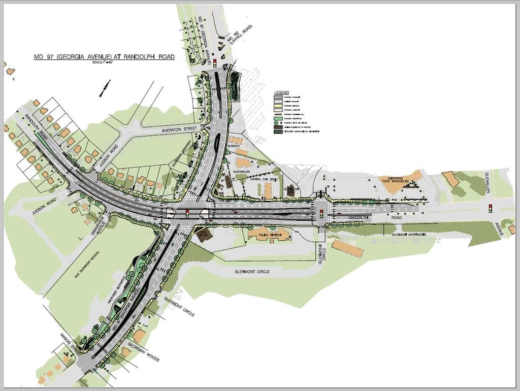
10 STREET NETWORK Glenmont has a significant amount of transportation infrastructure in place and planned (e.g., the new Georgia Avenue/Randolph interchange). With the proposed new growth in the Plan, the intersections are expected to operate within the congestion standards for the Glenmont Sector Plan area. Map 1 shows the existing and proposed street network. Table 4 describes the classification and function of each master-planned roadway in the Sector Plan area. Georgia Avenue / Randolph Interchange The 1997 Sector Plan recommended a grade-separated interchange for Georgia Avenue and Randolph to reduce congestion at the intersection, improve the flow of through traffic on both roads, help reduce cut-through traffic, and add development capacity to support mixed-use development. This Plan continues to support the proposed interchange and recommends that adequate vehicular access to the Glenmont Shopping Center from all points be provided to support the future redevelopment of the shopping center. Map 1: Network 9
11 Table 4 Master Planned Streets Major Highways Georgia Avenue (MD 97) Layhill (MD 182) Randolph Arterials Glenallan Avenue Primary Residential Streets Denley Street Classification From To Master Plan of Highways No. Minimum ROW 1 Number of Through Travel Lanes 2 Design Standard 2 Weller Denley M Divided Mod Denley Layhill M Divided Mod Layhill Randolph M Divided Mod Randolph 500 South of M Divided Mod Randolph 500 South of Randolph Mason Street M Divided Mod Hathaway Drive Glenallan Avenue M Divided Glenallan Avenue Georgia Avenue M [6] 4-Divided Mod Lindell Street / Judson M Divided Mod Denley Judson 400 West of M Divided Mod Glenallan Avenue 400 West of Middlevale M Divided Mod Glenallan Avenue Pavement Width Georgia Avenue Layhill A feet Mod Layhill 450 North of Randolph 450 North of A feet Mod Randolph Randolph A feet Mod Pavement Width Georgia Avenue Randolph P Feet Lindell Street Randolph Mason Street P Feet Judson Randolph Lindell Street P Feet Mod Briggs Lutes Drive Layhill P Feet Mod Layhill Middlevale Lane P Feet Mod Middlevale Lane Briggs Randolph P Feet Mod Weller Holdridge Georgia Avenue P Feet Mod New Internal s Number of Through Travel Lanes 2 New Street (MetroCenter Drive) Georgia Avenue Layhill P New Street Layhill Randolph P Mod (Winexburg Manor) New Layhill Randolph B (Glenmont Shopping Center) New Georgia Avenue Randolph B (Glenmont Shopping Center) Erskin Avenue Glenallan Avenue extended Wallace Avenue extended Glenallan Avenue Reflects minimum right-of-way, and may not include lanes for turning, parking, acceleration, deceleration, or other purposes. Rights-ofway are generally measured symmetrically from the ROW centerline. 2 Reflects the most representative roadway cross-section. New streets B-1, B-2, P-26 and P-27 may be constructed as private streets subject to use easements meeting the requirements described in the Plan text. The target speed 10
12 The interchange 11
13 As part of the interchange project, the Maryland State Highway Administration (SHA) prepared several design alternatives for a left-turn from the east bound service road along the south side of Randolph into the shopping center. The final seven alternatives included four different variations of a jughandle option, and three other alternatives (see Figure 1 to 7). While this Plan does not specifically endorse the final design and operational details of the selected alternative, one of the jug-handle alternatives (Alternative 1) best supports the goals of this Plan including adequate access into the shopping center from Randolph. This Plan defers to the SHA and MCDOT to select the appropriate Alternative for the shopping center access. Figure 1: Alternative 1 12
14 Figure 2: Alternative 2A Figure 3: Alternative 2B 13
15 Figure 4: Alternative 3 Figure 5: Alternative 4 14

16 Figure 6: Alternative 5A Figure 7: Alternative 5B 15
17 Layhill Improvements Residents and Planning staff have identified a need for pedestrian safety improvements at the intersection of Layhill and Georgia Avenue. The 1997 Glenmont Plan recommended a bifurcation of Layhill stating that the bifurcation would improve access from Georgia Avenue and Layhill to the Glenmont Shopping Center, reduce pedestrian and vehicular conflicts, improve the level of service at the intersection of Georgia Avenue/Layhill, and improve the flow of through traffic along Georgia Avenue. (Page 53). Planning staff investigated if the bifurcation was still the best way to achieve the goal of increasing pedestrian safety at Layhill and Georgia Avenue. Staff studied the following five (5) different alternatives, including the bifurcation (Figure 8). Option 1. Layhill Bifurcation ( 97 Sector Plan Recommended Option, Figure 8). The bifurcation would consist of maintaining the northbound leg of Layhill in its existing location, but relocate the southbound lane and place it between the existing Metro parking garage and the existing businesses in the Layhill Triangle. It would create two separate intersections of Layhill with Georgia Avenue and would be expected to reduce pedestrian and vehicular conflicts at the current intersection of Georgia Avenue and Layhill. The 1997 Sector Plan recommended a 70-foot ROW for each bifurcated segment, including three travel lanes. It recommended a clearly marked bikeway on each leg of the bifurcated roadway, and a 15-foot-wide sidewalk along each one-way segment of the street, including a tree panel along the curb, a sidewalk and pedestrian lighting. The Plan recognized that bifurcation may require Judson to become right-in, right-out only. The bifurcation may allow existing businesses on Layhill to expand their parcels to the south via the abandonment of the existing southbound lanes of the existing roadway. 16

18 Figure 8: Layhill Bifurcation 1997 Glenmont Sector Plan 17
19 Option 2. Layhill Realignment This option builds upon the idea of Layhill bifurcation but realigns the entire Layhill between Glenallan Avenue and Georgia Avenue and connects it with Georgia Avenue at Urbana Drive. The realigned road would have the same characteristics as existing Layhill : 120-foot ROW and 15-foot-wide sidewalks with green panels on both sides of the street. However, this realignment would require the relocation of the Washington Suburban Sanitary Commission (WSSC) water tower located on the Layhill Triangle, and it would have major impacts on the properties located in the Layhill Triangle. Option 3. Partial Layhill Realignment. In this option, Layhill would continue along its current alignment and transition at some point west of the WSSC water tower to make a T-intersection with Georgia Avenue. Although this option does not have any impacts on the water tower property, it would have major impacts on the properties located in the Layhill Triangle, and would require major changes to the traffic signals in the area. Option 4. diet and spot improvements. This option would retain the current alignment of Layhill between Glenallan Avenue and Georgia Avenue, but it would modify the Layhill intersection with Georgia Avenue to create a more defined T-intersection that would eliminate the free-rights at the existing intersection. And it would reduce the Layhill width from the existing six lanes to four lanes (road diet). Reducing Layhill to four-lanes would provide a shorter distance for pedestrians crossing the road, and it would have two bicycle/pedestrian benefits: 1) it would allow the widening of the sidewalks on Layhill and include tree panels; and 2) it would allow the installation of bike lanes on Layhill. These improvements are consistent with Code No ; Divided Suburban Arterial 4 lanes open section with bike lanes. Based on intersection congestion standards established in the Local Area Transportation Review and Policy Area Mobility Review Guidelines (LATR & PAMR), the reduction in travel lanes from six to four is not expected exceed acceptable congestion standards. Option 5. Spot Improvements. This option would eliminate the free-rights at the Georgia/Layhill intersection but maintain Layhill as a six-lane divided road. As with Option 4, the existing intersection with free-rights would be reconfigured to create a better T-intersection. After reviewing the property impacts, impacts on traffic congestion, and the time and costs associated with each Option, Staff decided that the bifurcation recommendation from the 1997 Sector Plan should not be continued. Instead, staff is recommending Option 4, diet and spot improvements. This Option would allow pedestrians to cross a narrower section of Layhill than they do today, which will improve pedestrian circulation and safety at the Layhill/Georgia intersection and it will not require any acquisition of ROW from property owners in the Layhill Triangle. Figure 9 below compares the five options: 18

20 Figure 9: Layhill Improvement Alternatives Bifucate Layhill Abandon existing southbound Layhill Existing Conditions Option 1: Layhill Bifurcation Realign Layhill Partially Realign Layhill Abandon existing Layhill Abandon existing Layhill p Option 2: Layhill Realignment Option 3: Partial Layhill Realignment Eliminate Free Rights and Realign Intersection Eliminate Free Rights and Realign Intersection Eliminate Outside Lanes Option 4: diet and spot improvements Option 5: Spot Improvements 19
21 BICYCLE AND PEDESTRIAN SYSTEM The Bicycle Network This Plan seeks to improve upon the existing and proposed bikeway network based on the 2005 Countywide Bikeways Functional Master Plan, and provides guidance for implementing the proposed network with future redevelopments. Currently, there is a 10-foot wide shared use (walking, biking) path (SP-29) along the west side of Georgia Avenue from Randolph north to Glenallan Avenue. This Sector Plan is confirming the 97 Plan s recommendation of a shared use path, SP-29, south to Mason Street. The Plan also confirms the planned shared use path (SP-26) along Randolph through the limits of this Sector Plan. Layhill is designated as having bike lanes (BL-18) between Georgia Avenue and Matthew Henson State Park. Within the Sector Plan Area, the bike lanes already exist and are currently stripped from Middlebridge Drive south to just north of Glenallan Avenue. The remaining planned bikeways are detailed in Table 5 and Map 3. Table 5 Countywide and Local Bikeways Master Planned Bikeways From To Master Plan of Bikeways No. Bike Lane Layhill (MD 182) Georgia Avenue (MD 97) Hathaway Drive BL-18 Shared Use Paths Georgia Avenue (MD 97) Weller Denley SP-29 Glenmont Greenway Denley Mason Street SP-29 Glenallan Avenue Georgia Avenue (MD 97) Randolph SP-24 Randolph Kemp Mill SP-24 Randolph Denley Middlevale Lane SP-26 Jingle Connector Jingle Lane Jingle Lane LB-1 Saddlebrook Connector Acorn Hollow Lane Randolph LB-2 Saddlebrook Drive Extension Saddlebrook Drive Saddlebrook Connector LB-3 Glenmont Forest Connector Randolph Wheaton Regional Off Path (PB-46) LB-4 Flack Connector Flack Street Glenmont Greenway LB-5 Briggs Briggs Court Lutes Drive LB-8 Signed Shared ways Flack Street Weller Flack Connector LB-6 Briggs Weller Briggs Court LB-7 Briggs Lutes Drive Middlevale Lane LB-9 Grandview Randolph Mason SR-20 Urbana Drive Denley Georgia Avenue (MD 97) LB-10 Weller Holdridge Briggs LB-11 Lutes Drive Dressler Lane Briggs LB-12 Middlevale Lane Briggs Randolph LB-13 Livingston Street Lindell Street Urbana Drive LB-14 Mason Street Georgia Avenue (MD 97) Grandview Avenue LB-15 Acorn Hollow Lane Briggs Saddlebrook Connector LB-16 20

22 Bicycle and Pedestrian Priority Area One of the Plan s goals is to transform Georgia Avenue (MD 97), Randolph, and Layhill (MD 182) into boulevards with enhanced medians, wider sidewalks, tree panels, bikeway improvements and better pedestrian crossings. The State s Bicycle-Pedestrian Priority Area designation is one of the tools to accomplish this goal. Map 3 In accordance with Access 2000 legislation passed in 1995, this designation will require the State to prioritize pedestrian and bicycle improvements and allow changes to State highways (Georgia Avenue and Layhill in this Plan) to improve safety for pedestrians and bicyclists. It could, where appropriate, affect the construction, design and maintenance of State roads. This designation is part of the County Executive s 2008 Pedestrian Safety Initiative and has been suggested for several master plan areas including White Flint, Germantown, and Kensington. State agreement is required before the designation can be implemented. This designation will enable complementary bikeway improvements on these two roads. Therefore, this Plan is recommending that Glenmont be designated as a Bicycle and Pedestrian Priority Area. 21
23 Bicycle Connections to Parks Glenmont is near two of the most heavily used parks in Montgomery County: Wheaton Regional Park and Brookside Gardens. Although bikeway connections between Glenmont and these facilities exist along Glenallan Avenue within the sector Plan boundary at Randolph, the proposed extension of the this connection in the larger K/W Plan would help achieve the goal of improving bicycle connections in the Sector Plan. In addition, this Plan is recommending a new bikeway connection to Brookside Gardens via the Glenmont Forest property if it redevelops. Secure Bike Parking at Metrorail Metro has recently opened and begun testing a new Bike-&-Ride facility on the first floor of the College Park Metro station. It is a secure, enclosed 2,400-square-foot parking structure with space for more than 100 bikes. WMATA should explore if Glenmont is an appropriate location for a new Bike & Ride facility. The Pedestrian Network The Plan proposes improving the pedestrian experience in Glenmont through redevelopment. This will occur as wider new sidewalks with tree panels are constructed as part of redevelopment of properties. Table 6 shows accident data between 2009 and 2011 for eight intersections in Glenmont: Table 6: Crash Data Intersection Georgia Avenue and Randolph Georgia Avenue and Layhill Georgia Avenue and Glenallan Georgia Avenue amd Hathaway Glenallan and Layhill Georgia Avenue and Urbana Drive Randolph and Glenmont Circle Glenallan and Randolph Total Crashes ( ) Pedestrian Involved accidents AADT 47,400 44,140 11,700 37,350 17,850 30,500 31,950 35,962 22
24 Transportation/Land Use Balance Since the early 1980s, every master plan has considered the balance between land use and transportation by assessing area-wide conditions forecasted for end-state conditions of the plan. This assessment indicates whether or not the proposed development will be supported by the existing and proposed transportation infrastructure (roads and transit service). The transportation/land use balance is measured by using a computer model, which predicts the adequacy of future traffic conditions based on proposed changes to housing, jobs and transportation infrastructure in the area. A Plan is considered to be in balance if the results of the modeling effort demonstrate that the proposed infrastructure will support the planned growth in accordance with the standards of maximum allowed road congestion established for the planning area. Measures of Effectiveness The analysis of the Plan s transportation/land use balance uses three measures: Area-wide mobility is measured by standards established in the Local Area Transportation Review (LATR) and Policy Area Mobility Review (PAMR) Guidelines. PAMR indicates the degree to which the proposed development would be supported by the proposed transportation infrastructure (roads and transit) on a policy area wide basis. This analysis uses a regional model and covers a much larger area than the Glenmont Sector Plan. Intersection congestion is also measured by standards established in the LATR and PAMR Guidelines. For intersection congestion analysis, the LATR guidelines specify the use of Critical Lane Volume (CLV) as the measure of levels of congestion at certain key intersections in the Plan area. A cordon-line analysis compares the amount of traffic generated by changes to local land uses and their effect on regional traffic within a defined area (cordon). Policy Area Mobility Review (PAMR) PAMR, introduced into the County Growth Policy in 2007, measures the transportation system s adequacy by comparing Relative Transit Mobility and Relative Arterial Mobility for each of the County s 21 policy areas. It continues a long-standing County policy that higher levels of roadway congestion are appropriate in areas with higher quality transit service (Metrorail), such as Glenmont. This policy provides multimodal equity across the County and facilitates the development of pedestrian-oriented, rather than auto-oriented, improvements in Metro Station Policy Areas (MSPAs). The Glenmont Sector Plan area is located within the Kensington/Wheaton Policy Area. Figure 10 shows the forecasted PAMR conditions for all County policy areas for For the K/W Policy Area forecast in this figure, the standard Round 8.0, 2040 forecast was modified to include a high scenario for Glenmont, which was an extremely aggressive estimate of a theoretical worst case (from a traffic standpoint) development scenario, much higher than the proposed Plan s build-out scenario listed in the Staff Draft Sector Plan. Table 7, also based on the modified 2040 estimate for the K/W Policy Area, summarizes the supporting travel data, including vehicle miles of travel (VMT) and vehicle hours of travel (VHT) for both free-flow and congested conditions.. 23
25 The modeling result indicated that, with the high scenario of development in Glenmont, the Kensington/Wheaton Policy Area would operate at: Relative Transit Mobility of 91 percent (Level of Service (LOS) B between 75 percent and 100 percent) Relative Arterial Mobility of 42 percent (LOS D between 40 percent and 55 percent). The current Subdivision Staging Policy requires that all policy areas have a Relative Arterial Mobility of at least 40 percent, or LOS D conditions, regardless of the level of transit service. The PAMR analysis for the high development scenario in Glenmont meets this threshold, and therefore, the Plan is considered to be in balance. 24

26 Figure 10: Forecast (2040) PAMR for Glenmont Sector Plan 25

27 Table7: Policy Area Mobility Review Table PAMR Results by Policy Area Glenmont Sector Plan 26
28 Local Area Transportation Review The Local Area Transportation Review (LATR) measures congestion at intersections by applying the Critical Lane Volume (CLV) method as described in the Planning Department s LATR guidelines. Calculated CLV values are converted to a volume-to-capacity measurement (V/C ratio) by dividing the current or forecasted CLV values by the applicable congestion standard. The use of the Critical Lane Volume (CLV) in support of the Sector Plan is consistent with the Subdivision Staging Policy. Maximum acceptable congestion standards for each policy area are determined based on the degree to which alternative modes of transportation are available in each area. In rural policy areas, where few alternatives to auto exist, the congestion standard is maximum 1,350 CLV (the middle range of LOS D). In metro station policy areas, where multiple modes of travel are available, the congestion standard is maximum 1,800 CLV. Currently, intersections in the Glenmont Plan area have a congestion standard of 1,800 CLV. The Plan area is surrounded by the Kensington/Wheaton Policy Area, which has a lower CLV standard of 1,600. The availability of Metrorail service in Glenmont helped reduce the additional vehicular trips generated by the new development proposed in the Draft Sector Plan by 18 percent. Table 7 summarizes three sets of V/C ratios: 1) existing (observed), 2) the 1997 Plan buildout, and 3) the proposed Sector Plan buildout (including Layhill improvements discussed above) for certain critical intersections in Glenmont. The existing CLV ratios are from the M-NCPPC Intersection Analysis Application taken in 2008 and Future CLV results include the construction of the fully funded interchange at the intersection of Georgia Avenue and Randolph. Results in Table 7 indicate that intersection volumes remain below their permitted maximum standards despite the higher densities proposed in the Draft Sector Plan. Intersection results are color-coded: red intersections have a V/C ratio above 100 percent of the maximum allowed standard (bold and italic) orange intersections have a V/C ratio between 81 and 100 percent of the maximum allowed standard (bold) yellow intersections have a V/C ratio between 61 and 80 percent of the maximum allowed standard (italic) green intersections have a V/C ratio up to 60 percent of the maximum allowed standard. The intersection of Georgia Avenue at Hathaway Drive is actually outside of the Plan area boundaries and therefore has a lower LATR standard of 1600 CLV. V/C results depicted in Table 7 below indicate that the Glenmont road network is well equipped to handle the Plan s proposed level of growth. 27
29 Table 7: Volume to Capacity Ratios for Glenmont Intersections Observed 1997 Sector Plan Buildout 1 Proposed Sector Plan Buildout 2 Intersection LATR Standard AM PM AM PM AM PM (CLV) CLV CLV CLV CLV CLV CLV Georgia Avenue & Hathaway Georgia Avenue & Glenallan Georgia Ave & Urbana Dr/Metro Georgia Ave & Layhill Rd Georgia Ave & Randolph Rd Layhill Rd & Glenallan Ave Randolph Rd & Glenallan Ave Randolph Rd & Glenmont Circle V/C ratio = maximum CLV standard actual or projected CLV 1 20 to 30-year estimate of development in the 1997 Sector Plan buildout 2 Used to test the capacity of infrastructure including road network and school enrollment 3 Georgia Avenue and Layhill future CLV values assume a 4-lane road diet section and spot improvements. 28
30 Synchro Analysis The Subdivision Staging Policy (SSP) directed the Park and Planning Commission to use Synchro or other Highway Capacity Manual (HCM) software to determine queuing and delay. As a result, the 2013 Local Area Transportation Review and Transportation Policy Area Review Guidelines directed the Park and Planning Commission to use the Synchro Volume/Capacity (V/C) ratio for any intersection operating above a CLV of County Council Policy has been that every Master Plan must be in transportation balance. This means that all of the designated intersections must operate at an acceptable LOS (CLV and V/C). In a Metro Station Policy Area such as Glenmont that means a CLV of 1800 or below and a V/C ration of 1.13 or below. Using the modeling results stated in the Local Area Transportation Review section noted above, a Synchro analysis was undertaken looking at four scenarios:. These four scenarios were: 1) existing conditions, 2) Year 2040 but without the proposed land use in Glenmont and the Georgia /Randolph interchange; 3) Year 2040 with the proposed land use and the interchange; and 4) Year 2040 with the proposed land use, the interchange, and reducing Layhill to 4 lanes between Georgia and Glenallan Avenues. Table 9 below shows the levels of intersection congestion in both the AM and PM peak hour. Under the scenario with the Sector Plan s proposed land use and programmed interchange, the only intersections that are projected to fail are 1) Randolph /Glenallan Avenue and 2) Georgia Avenue and Layhill. However, under future conditions, there are ways that these two intersections can be improved and achieve an acceptable LOS. For Randolph and Glenallan Avenue, there are currently two lanes on southbound Glenallan Avenue; an exclusive left turn lane and a combined left-through-right lane. At this intersection, the addition of an exclusive right turn lane from southbound Glenallan Avenue to westbound Randolph would improve the LOS at that intersection to a V/C ratio of 1.12 in the AM peak hour and 0.91 in the PM peak hour, both within acceptable standards. For the intersection of Georgia Avenue and Layhill, as discussed on page 16, there is a desire for improvements to this intersection to improve pedestrian safety. On northbound Georgia Avenue, there are currently four lanes approaching Layhill (three through lanes and one exclusive channelized right turn lane). The idea of eliminating the channelized right lane would admittedly cause a delay for vehicles, but would improve conditions for pedestrians. The Synchro analysis found that if you maintained the existing four lanes and changed the right turn lane to a signal controlled right turn lane, the resulting intersection would result in a V/C ratio of 0.82 in the AM peak hour and 1.00 in the PM peak hour, both within acceptable standards. 29
31 Table 8: Synchro V/C analysis Existing 2040 Volumes without Added land Use and existing transportation network 2040 Volumes without Added land Use and Georgia / Randolph Interchange 2040 Volumes without Added land Use and Georgia / Randolph Interchange & 4 lane Layhill Intersection Synchro V/C standard V/C Ratio (AM) V/C Ratio (PM) V/C Ratio (AM) V/C Ratio (PM) V/C Ratio (AM) V/C Ratio (PM) V/C Ratio (AM) V/C Ratio (PM) Georgia Avenue & Glenallan Georgia Ave & Layhill Rd Randolph Rd & Glenallan Ave Layhill Rd & Glenallan Ave diet on Layhill maintaining northbound right-turn lane from Georgia Avenue to Layhill as a controlled right turn; Judson one lane outbound. 2 Randolph /Glenallan Avenue with an exclusive southbound right turn lane on Glenallan Avenue. Cordon Line Analysis A cordon line analysis gives a picture of traffic entering and exiting a defined area. It includes both through and local trips, and there is no maximum acceptable congestion standard or threshold in this analysis. It only shows the projected increase in number of vehicles passing through a defined area based on the proposed level of growth. Figure 10 compares peak hour trips crossing into and out of the Plan area for existing conditions, estimated 97 Plan buildout, and the proposed Plan s build-out scenario.. 30
32 Number of trips crossing into and out of the Plan Area Figure 10: Draft Plan Trip Generation Comparison Observed Sector Plan Buildout 2000 Proposed Sector Plan Buildout 0 AM In AM Out PM In PM Out Peak Hour Trip Direction Transportation Policy Area Review (TPAR) In 2012, the County Council replaced PAMR with a new area-wide transportation test called TPAR. TPAR analyzes roadway and transit levels of service in each policy area and compares the results to a service standard for a particular policy area. The TPAR analysis performed in support of the 2012 Subdivision Staging Policy (which modeled the adopted master plans yield forecasts for 2040) is sufficient for the proposed Glenmont Sector Plan because the results for the broader Kensington/Wheaton Policy Area fall well within the acceptable roadway adequacy threshold. Compared to the larger K/W Policy area, the proposed changes in the Glenmont Sector Plan Area are relatively small, and therefore would not create an imbalance under TPAR. 31
 is forecasted to be 42%.")
33 Figure 13 shows the TPAR adequacy of main roads in Montgomery County, sorted by Policy Areas, for the Year The ratio of peak-direction congested speeds to free-flow speeds in the K/W Policy Area (highlighted in yellow) is forecasted to be 42%. This measure is above the 40 percent adequacy standard for the policy area. Figure 13: Year 2040 Policy Area way Adequacy 32

34 Travel Demand Forecasting Process and Local Area Modeling Process Assumptions The specific computer modeling techniques used in the PAMR, LATR and Cordon line analyses described in this Appendix are described below: The first step in determining the policy-wide PAMR results is to use the TRAVEL/3 model analysis, which incorporates region-wide land use and transportation assumptions provided by the Metropolitan Washington Council of Governments (MWCOG). The TRAVEL/3 forecasting assumptions include: 1) A 2040 horizon year (the most distant horizon year for which forecast land use and transportation system development is available); and 2) Regional growth per the MWCOG Cooperative Forecasting Process. For the Washington Metropolitan region, the Round 8.0 forecasts include an increase from three million jobs and 1.9 million households in 2005 to 4.2 million jobs and 2.5 million households in And for Montgomery County, the Round 8.0 forecasts include an increase from 500,000 jobs and 347,000 households in 2005 to 670,000 jobs and 441,300 households in The TRAVEL/3 model for the Glenmont Plan and surrounding area comprised seven (7) Transportation Analysis Zones TAZs (Map 4). Map 4: Glenmont Sector Plan TAZs 33
35 TRAVEL/3 is a standard four-step model consisting of: trip generation: person trips generated by land use type and density within each Transportation Analysis Zone (TAZ) trip distribution: person trips generated in each TAZ that travel to each of the other TAZs within the metropolitan area mode split: travel mode of the person trips, including single-occupant auto, multiple-occupant auto, transit, or non-motorized mode such as walking or bicycling traffic assignment: roadways used for vehicular travel between TAZs. The next level of analysis in deterring producing the cordon line analysis, consists of using industry standard techniques described in the National Cooperative Highway Research Project (NCHRP) Report 255 to modify the TRAVEL/3 outputs. These modifications include refining the morning and evening peak hour forecasts to reflect a finer grain of land use and network assumptions than included in the regional model. The third and final level of analysis used to determine the CLV values includes intersection congestion, described in the PAMR /LATR Guidelines. A quick response technical analysis method was used to forecast intersection performance in the Glenmont area. The Department s Local Area Modeling (LAM) process applied in the Glenmont Plan analyses used NCHRP Report 255 techniques to convert the TRAVEL/3 system level forecasts to intersection-level forecasts (CLVs). The LAM process uses customized trip generation rates that reflect both existing conditions and future changes, considering both the land use types and changes in travel behavior. Table 9 shows the trip generation rates used in the LAM. Table 9: Local Area Model Peak Hour Trip Generation Land Use Units AM PM Office 1000 Square Feet Retail 1000 Square feet Multifamily residential Dwelling unit These trip generation rates reflect a combination of LATR rates for development similar to that envisioned for Glenmont, and were calibrated so that LAM-simulated traffic volumes match observed traffic counts in the Glenmont area. The calibration process considered the amount of through traffic on the roadway network so that the LAM volumes at the network cordon line are within one percent of observed count data for both morning and evening peak hours. The trip generation rates shown in Table 9 are generally lower than those found in the Institute of Transportation Engineers (ITE) trip generation report, particularly for commercial land uses. The rates reflect the fact that ITE rates for most commercial locations do not have the transit availability found in Glenmont. The difference for residential uses is not quite as high because ITE multifamily trip generation 34
36 rates do reflect the fact that most multifamily housing units have sufficient density to support transit service. Finally, the retail trip generation rates in the Glenmont zones also incorporate a discount for pass-by and diverted-link trips. Table 10 depicts the land use assumptions modeled to determine the LATR results. A land-use scenario with a higher density than what was used for LATR, was used to determine the PAMR and cordon-line results. Table 10: Existing and proposed development estimates (for the entire Sector Plan area) Existing Land Use 1997 Sector Plan Buildout 1 Projected Sector Plan Buildout 2 Proposed Sector Plan Buildout 3 Non- 402, , , ,000 Residential s.f. Housing Units 3,100 4,600 6,335 8,900 Jobs 873 1,278 2,180 2,350 Jobs-Housing Ratio 0.3:1 0.3:1 0.3:1 0.3: year estimate of development for the 1997 Sector Plan 2 Buildout excluding potential redevelopment Glenmont Forest and Winexburg Apartments 3 Buildout including potential redevelopment of Glenmont Forest and Winexburg Apartments if the properties are rezoned in a future Local Map Amendment. Used to test the capacity of infrastructure including road network and school enrollment As with all Master Plans, the Glenmont Sector Plan s transportation analysis and plans were made in close coordination with both the SHA and MCDOT. The area-wide transportation analysis used in the Glenmont Sector Plan is consistent with other Sector Plan/Master Plans that are being studied at the same time; Chevy Chase Lake, White Oak Science Gateway and Long Branch. The transportation analysis and modeling that was performed in support of this Sector Plan is not the same as a traffic study for a specific site. The transportation modeling is used to determine is if the proposed land uses are in balance with the recommended transportation network. Any and all developments in Glenmont will be subject to the Adequate Public Facilities Ordinance (APFO) development review process. 35
Preliminary Transportation Analysis
 Preliminary Transportation Analysis Goals of a Robust, Multimodal Transportation Network Safe Accessible/Connected Efficient Comfortable Context-Sensitive Motor Vehicle: Continue to analyze the data to
Comments EXECUTIVE SUMMARY
 Comments 1. Under any Alternatives, MCDOT should provide better at-grade pedestrian crossing of Georgia Avenue and Forest Glen Road, including improved crosswalks with wider medians and adequate signal
Presentation of Staff Draft March 18, 2013 COUNTYWIDE TRANSIT CORRIDORS FUNCTIONAL MASTER PLAN
 Presentation of Staff Draft March 18, 2013 COUNTYWIDE TRANSIT CORRIDORS FUNCTIONAL MASTER PLAN Public Outreach Fall 2011: Two community meetings/open houses Fall 2012: Three community meetings/open houses
Ownership Lots 17 & 18 (Part of Lot 14), Montgomery Auto Sales Park
, Montgomery Auto Sales Park") Traffic Impact Analysis Ownership Lots 17 & 18 (Part of Lot 14), Montgomery Auto Sales Park Silver Spring, MD Lot 17: Site Plan No. 821413 Lot 18: Site Plan No. 821414 Filing Number: 13-TS-1198527A Prepared
Traffic Impact Analysis Ownership Lots 17 & 18 (Part of Lot 14), Montgomery Auto Sales Park Silver Spring, MD Lot 17: Site Plan No. 821413 Lot 18: Site Plan No. 821414 Filing Number: 13-TS-1198527A Prepared
WHITE OAK SCIENCE GATEWAY MASTER PLAN Transportation Appendix
 WHITE OAK SCIENCE GATEWAY MASTER PLAN Transportation Appendix Montgomery County Planning Department M-NCPPC www.montgomeryplanning.org Contents Master Plan and Study Area Boundaries... 1 Existing Conditions
Countywide Transit Corridors Functional Master Plan
 Countywide Transit Corridors Functional Master Plan Makeover Montgomery II May 10, 2014 Master Plan Status Begun: August 2011 Planning Board Approved Draft Plan: July 2013 Council Approved Final Plan:
RCCG Jesus House. Preliminary Plan # TRAFFIC STUDY. Prepared for: RCCG Jesus House Montgomery County, Maryland
 TRAFFIC STUDY Prepared for: Montgomery County, Maryland Prepared by: SSSTS Consulting (410) 718-8660(410) 718-8660 Table of Contents SECTION 1 - INTRODUCTION... 1 SECTION 2 - EXISTING CONDITIONS... 4 Public
MONTGOMERY COUNTY PLANNING DEPARTMENT
 MONTGOMERY COUNTY PLANNING DEPARTMENT THE MARYLAND-NATIONAL CAPITAL PARK AND PLANNING COMMISSION Veirs Mill Corridor Master Plan: Work Session #5 MCPB Item No. Date: 10/04/18 Jessica McVary, Planner Coordinator,
4. ENVIRONMENTAL IMPACT ANALYSIS 9. TRANSPORTATION AND TRAFFIC
 4. ENVIRONMENTAL IMPACT ANALYSIS 9. TRANSPORTATION AND TRAFFIC 4.9.1 INTRODUCTION The following section addresses the Proposed Project s impact on transportation and traffic based on the Traffic Study
Proposed White Flint Separated Bike Lane Network September 2015
 Proposed White Flint Separated Bike Lane Network September 2015 Abstract This report includes a proposed separated bike lane network for the White Flint Sector Plan area. Separated bike lanes create a
MONTGOMERY COUNTY PLANNING DEPARTMENT THE MARYLAND-NATIONAL CAPITAL PARK AND PLANNING COMMISSION
 MONTGOMERY COUNTY PLANNING DEPARTMENT THE MARYLAND-NATIONAL CAPITAL PARK AND PLANNING COMMISSION MCPB Item No. 4 Date: 04-17-14 2014 Mobility Assessment Report José Dory, Senior Planner, Functional Planning
MONTGOMERY COUNTY PLANNING DEPARTMENT THE MARYLAND-NATIONAL CAPITAL PARK AND PLANNING COMMISSION
 MONTGOMERY COUNTY PLANNING DEPARTMENT THE MARYLAND-NATIONAL CAPITAL PARK AND PLANNING COMMISSION SHA CTP Project No. MO891A21, US 29, Fairland Road to Musgrove Road Interchange Improvement, Design Review
Abstract. Source of Copies The Maryland-National Capital Park and Planning Commission 8787 Georgia Avenue Silver Spring, MD 20910
 1 Abstract This document contains an examination of and recommendations for transit, bicycle, and pedestrian infrastructure that will help create complete transportation options. With the approval and
City of Wayzata Comprehensive Plan 2030 Transportation Chapter: Appendix A
 A1. Functional Classification Table A-1 illustrates the Metropolitan Council s detailed criteria established for the functional classification of roadways within the Twin Cities Metropolitan Area. Table
MONTGOMERY COUNTY PLANNING DEPARTMENT THE MARYLAND-NATIONAL CAPITAL PARK AND PLANNING COMMISSION
 MONTGOMERY COUNTY PLANNING DEPARTMENT THE MARYLAND-NATIONAL CAPITAL PARK AND PLANNING COMMISSION MCPB Item No. 3 Date: 01-19-12 Worksession: Countywide Transit Corridors Functional Master Plan Larry Cole,
Complete Street Analysis of a Road Diet: Orange Grove Boulevard, Pasadena, CA
 Complete Street Analysis of a Road Diet: Orange Grove Boulevard, Pasadena, CA Aaron Elias, Bill Cisco Abstract As part of evaluating the feasibility of a road diet on Orange Grove Boulevard in Pasadena,
M-58 HIGHWAY ACCESS MANAGEMENT STUDY Mullen Road to Bel-Ray Boulevard. Prepared for CITY OF BELTON. May 2016
 M-58 HIGHWAY ACCESS MANAGEMENT STUDY Prepared for CITY OF BELTON By May 2016 Introduction Missouri State Highway 58 (M-58 Highway) is a major commercial corridor in the City of Belton. As development has
5.0 Roadway System Plan
 Southwest Boise Transportation Study Page 16 5.0 Roadway System Plan The Roadway System Plan outlines roadway improvements in the Initial Study Area. It forecasts future deficiencies on the arterial system,
Chapter 5 Future Transportation
 Chapter 5 Future Transportation The Future Land Use Plan identifies the desired land use designations. The land uses desired for Crozet depend, in large part, on the success of the transportation system,
APPENDIX 14: CONNECTIONS: TRANSPORTATION ANALYSIS. Transportation Planning, Analysis
 APPENDIX 14: CONNECTIONS: TRANSPORTATION ANALYSIS Transportation Planning, 2008 Germantown has various options of transportation for citizens in the community. There are major highways, buses, MARC, bicycle
TRAFFIC IMPACT STUDY CRITERIA
 Chapter 6 - TRAFFIC IMPACT STUDY CRITERIA 6.1 GENERAL PROVISIONS 6.1.1. Purpose: The purpose of this document is to outline a standard format for preparing a traffic impact study in the City of Steamboat
University Hill Transportation Study Technical Memorandum Alternatives Modeling and Analysis May 2007
 Technical Memorandum May 2007 Syracuse Metropolitan Transportation Council Edwards and Kelcey with Wallace Roberts and Todd Alta Planning and Design CONTENTS SECTION ONE- INTRODUCTION...1 SECTION TWO-
2014 Mobility Assessment Report Functional Planning & Policy Montgomery County Planning Department
 2014 Mobility Assessment Report Functional Planning & Policy Montgomery County Planning Department Travel Trends National & Local Travel Trends Multi-Modal Monitoring Pedestrian Bikes Bus Rail Future Efforts
Chapter 4 Traffic Analysis
 Chapter 4 Traffic Analysis PURPOSE The traffic analysis component of the K-68 Corridor Management Plan incorporates information on the existing transportation network, such as traffic volumes and intersection
APPENDIX E BIKEWAY PRIORITIZATION METHODOLOGY
 APPENDIX E BIKEWAY PRIORITIZATION METHODOLOGY INTRODUCTION The network of bikeways recommended in the Bicycle Master Plan is extensive and is likely to be only partially completed during the 25-year life
Appendix B: Forecasting and Traffic Operations Analysis Framework Document
 Existing Conditions Report - Appendix Appendix B: Forecasting and Traffic Operations Analysis Framework Document This document defines the methodology and assumptions that will be used in the traffic forecasting
APPENDIX 2 LAKESHORE ROAD TRANSPORTATION REVIEW STUDY EXECUTIVE SUMMARY
 APPENDIX 2 LAKESHORE ROAD TRANSPORTATION REVIEW STUDY EXECUTIVE SUMMARY Appendix 2 City of Mississauga Lakeshore Road FINAL REPORT Transportation Review Study December 2010 EXECUTIVE SUMMARY Study Purpose
Los Altos Hills Town Council - June 18, 2015 Palo Alto City Council June 22, AGENDA ITEM #2.B Presentation
 Los Altos Hills Town Council - June 18, 2015 Palo Alto City Council June 22, 2015 AGENDA ITEM #2.B Presentation Previous Presentations Los Altos Hills Town Council in May 2014 and February 2015 Palo Alto
Figure 1: East West Connector Alignment Alternatives Concept Drawing
 Page 2 of 9 Figure 1: East West Connector Alignment Alternatives Concept Drawing The Montebello Drive extension will run north south and connect Wilsonville Road to the Boones Ferry Road to Brown Road
Agenda. Overview PRINCE GEORGE S PLAZA METRO AREA PEDESTRIAN PLAN
 PRINCE GEORGE S PLAZA METRO AREA PEDESTRIAN PLAN May 28, 2008 Agenda Welcome and introductions Project overview and issue identification Planning context and strengths Design challenges and initial recommendations
Regional Transportation Needs Within Southeastern Wisconsin
 Regional Transportation Needs Within Southeastern Wisconsin #118274 May 24, 2006 1 Introduction The Southeastern Wisconsin Regional Planning Commission (SEWRPC) is the official areawide planning agency
Clackamas County Comprehensive Plan
 ROADWAYS The County s road system permits the movement of goods and people between communities and regions, using any of a variety of modes of travel. Roads provide access to virtually all property. They
MONTGOMERY COUNTY COUNCIL
 MONTGOMERY COUNTY COUNCIL R O C K V I L L E, M A R Y L A N D October 20, 2015 The Honorable Isiah Leggett Montgomery County Executive 101 Monroe Street, 2nd Floor Rockville, MD 20850 Dear County Executive
Route 7 Corridor Study
 Route 7 Corridor Study Executive Summary Study Area The following report analyzes a segment of the Virginia State Route 7 corridor. The corridor study area, spanning over 5 miles in length, is a multi
TAKOMA METRO STATION
 TKOM METRO STTION Traffic nalysis Technical Memorandum Station Planning in Support of Joint evelopment Job No. 13-FQ165-LN-2 November 213 WSHINGTON METROPOLITN RE TRNSIT UTHORITY (WMT) Takoma Metro Station
Appendix C. NORTH METRO STATION AREA TRAFFIC IMPACT STATEMENT 88th Avenue Station
 Appendix C NORTH METRO STATION AREA TRAFFIC IMPACT STATEMENT 88th Avenue Station Prepared for: Regional Transportation Department and URS Corporation as part of the North Metro EIS David Evans and Associates,
Moving Towards Complete Streets MMLOS Applications
 Moving Towards Complete Streets MMLOS Applications Transportation Education Series May 18 th, 2012 It s not just for cars! Presentation Overview The Complete Streets Movement What is Multi-Modal Level
TRANSPORTATION PLAN INTRODUCTION TRAVEL FORECASTING
 TRANSPORTATION PLAN INTRODUCTION Most of the Upper Rock Creek Planning Area is within one of the County s rural policy areas; only the Derwood section of the Planning Area is outside this rural classification.
THIS PAGE LEFT BLANK INTENTIONALLY
 GA SR 25 Spur at Canal Road Transportation Impact Analysis PREPARED FOR GLYNN COUNTY, GEORGIA 1725 Reynolds Street, Suite 300 Brunswick, Georgia 31520 PREPARED BY 217 Arrowhead Boulevard Suite 26 Jonesboro,
6.4 RECOMMENDED IMPROVEMENTS
 6.4 RECOMMENDED IMPROVEMENTS 6.4.1 Williston Road Recommendations While all alternatives would be an improvement over existing conditions, Alternative 3B is recommended over the others because it provides
Bradford s Landing. Preliminary Plan Abandonment AB753 & AB754 MONTGOMERY COUNTY PLANNING DEPARTMENT
 Bradford s Landing Preliminary Plan 120170060 Abandonment AB753 & AB754 1 Overview Staff recommends Approval of Preliminary Plan 120170060 with revised conditions and Adoption of the Resolution. 244 lots
Long Branch Sector Plan. Appendix 11 Transportation
 Long Branch Sector Plan Appendix 11 Transportation Plan Context and Initiatives The Long Branch Sector Plan presents a vision for the transition of the area to a neighborhood scale, transit-oriented, walkable
SANTA MONICA BOULEVARD CORRIDOR
 CIRCULATION ELEMENT WHITE PAPER NO. 3 SANTA MONICA BOULEVARD CORRIDOR INTRODUCTION From the 1930s to the beginning of Los Angeles freeway era, Santa Monica Boulevard, (previously Route 66, the Beverly
Bridge Street Corridor Study Report
 Bridge Street Corridor Study Report Prepared for: Prepared by: BRIDGE STREET CORRIDOR STUDY REPORT PREPARED FOR: CITY OF ARROYO GRANDE COMMUNITY DEVELOPMENT DEPARTMENT 300 EAST BRANCH STREET ARROYO GRANDE,
DUNBOW ROAD FUNCTIONAL PLANNING
 DUNBOW ROAD FUNCTIONAL PLANNING Final Report August 3, 216 #31, 316 5th Avenue NE Calgary, AB T2A 6K4 Phone: 43.273.91 Fax: 43.273.344 wattconsultinggroup.com Dunbow Road Functional Planning Final Report
Appendix 3 Transportation Analyses For more information, call the Transportation Division at Wheaton CBD and Vicinity Sector Plan
 Appendix 3 Transportation Analyses For more information, call the Transportation Division at 301-495-4525 montgomery county planning board maryland-national capital park and planning commission Contents
TRAFFIC STUDY GUIDELINES Clarksville Street Department
 TRAFFIC STUDY GUIDELINES Clarksville Street Department 9/1/2009 Introduction Traffic studies are used to help the city determine potential impacts to the operation of the surrounding roadway network. Two
Bikeway Elements. Study Area A: Needwood Road and Vicinity (Figures 3 and 4)
") B R I G G S C H A N E Y R O A D I N T E R C H A N G E The ROD includes a partial interchange at Briggs Chaney Road, which is not included in the Fairland Master Plan. This interchange includes ramps to
B R I G G S C H A N E Y R O A D I N T E R C H A N G E The ROD includes a partial interchange at Briggs Chaney Road, which is not included in the Fairland Master Plan. This interchange includes ramps to
Magnolia Place. Traffic Impact Analysis. Prepared for: City of San Mateo. Prepared by: Hexagon Transportation Consultants, Inc.
 Magnolia Place Traffic Impact Analysis Prepared for: City of San Mateo Prepared by: Hexagon Transportation Consultants, Inc. Updated January 4, 2010 Table of Contents 1. Introduction...1 2. Existing Conditions...6
Traffic Impact Analysis Walton Acres at Riverwood Athletic Club Clayton, NC
 Traffic Impact Analysis Walton Acres at Riverwood Athletic Club Clayton, NC 1. TABLE OF CONTENTS INTRODUCTION...1 1.1. Site Location and Study Area...1 1.2. Proposed Land Use and Site Access...2 1.3.
TRAFFIC IMPACT ANALYSIS
 TRAFFIC IMPACT ANALYSIS FOR THE CHAMPAIGN UNIT#4 SCHOOL DISTRICT PROPOSED HIGH SCHOOL (SPALDING PARK SITE) IN THE CITY OF CHAMPAIGN Final Report Champaign Urbana Urbanized Area Transportation Study 6/24/2014
List of Attachments. Location Map... Site Plan... City of Lake Elsinore Circulation Element... City of Lake Elsinore Roadway Cross-Sections...
 List of Attachments Exhibits Location Map... Site Plan... City of Lake Elsinore Circulation Element... City of Lake Elsinore Roadway Cross-Sections... Existing Lane Geometry and Traffic Controls... Existing
MONTGOMERY COUNTY PLANNING DEPARTMENT THE MARYLAND-NATIONAL CAPITAL PARK AND PLANNING COMMISSION
 MONTGOMERY COUNTY PLANNING DEPARTMENT THE MARYLAND-NATIONAL CAPITAL PARK AND PLANNING COMMISSION MCPB Item No. 5 Date: 12/3/15 Draft White Flint Separated Bike Lanes Network David Anspacher, Functional
Highway 111 Corridor Study
 Highway 111 Corridor Study June, 2009 LINCOLN CO. HWY 111 CORRIDOR STUDY Draft Study Tea, South Dakota Prepared for City of Tea Sioux Falls Metropolitan Planning Organization Prepared by HDR Engineering,
State Road 54/56 Tampa Bay s Northern Loop. The Managed Lane Solution Linking I-75 to the Suncoast Parkway
 State Road 54/56 Tampa Bay s Northern Loop The Managed Lane Solution Linking I-75 to the Suncoast Parkway SUNCOAST PARKWAY Both I 75 and the Suncoast Parkway are planning, or in the process of constructing,
City of Homewood Transportation Plan
 City of Homewood Transportation Plan Prepared for: City of Homewood, Alabama Prepared by: Skipper Consulting, Inc. May 2007 TABLE OF CONTENTS INTRODUCTION... 1 BACKGROUND INFORMATION... 1 EXISTING TRANSPORTATION
Harrah s Station Square Casino
 Transportation Analysis Harrah s Station Square Casino Pittsburgh, Pennsylvania Submitted To: City of Pittsburgh and Pennsylvania Gaming Control Board Prepared By: DKS Associates GAI Consultants December
TRANSPORTATION & MOBILITY
 TRANSPORTATION & MOBILITY ROADWAY SYSTEM There are approximately 40 miles of roadways in Manitou Springs. For planning purposes, roadways are typically assigned a functional classification which defines
TRAFFIC IMPACT STUDY COMPREHENSIVE UPDATE TOWN OF THOMPSON S STATION, TENNESSEE PREPARED FOR: THE TOWN OF THOMPSON S STATION
 TRAFFIC IMPACT STUDY COMPREHENSIVE UPDATE TOWN OF THOMPSON S STATION, TENNESSEE PREPARED FOR: THE TOWN OF THOMPSON S STATION Transportation Consultants, LLC 1101 17 TH AVENUE SOUTH NASHVILLE, TN 37212
Summary: Mercer County Princeton Avenue & Spruce Street Study January 2009
 Summary: Several recent studies have assessed potential development and redevelopment opportunities in the Mercer Crossing area of Trenton, Ewing, and Lawrence. This Princeton Avenue and Spruce Street
Dr. M.L. King, Jr. Street North Complete Streets Resurfacing Opportunities HOUSING, LAND USE, AND TRANSPORTATION COMMITTEE MARCH 22, 2018
 Dr. M.L. King, Jr. Street North Complete Streets Resurfacing Opportunities HOUSING, LAND USE, AND TRANSPORTATION COMMITTEE MARCH 22, 2018 What s Happening The City plans to mill and resurface Dr. M.L.
5858 N COLLEGE, LLC N College Avenue Traffic Impact Study
 5858 N COLLEGE, LLC nue Traffic Impact Study August 22, 2016 Contents Traffic Impact Study Page Preparer Qualifications... 1 Introduction... 2 Existing Roadway Conditions... 5 Existing Traffic Conditions...
Abstract. Source of Copies
 1 Abstract Local Area Transportation Review Guidelines Planning Board Updates: May 13, 2010, June 17, 2011, February 9, 2012 and January 24, 2013. These guidelines are to be used for preparation and review
133 rd Street and 132 nd /Hemlock Street 132 nd Street and Foster Street MINI ROUNDABOUTS. Overland Park, Kansas
 133 rd Street and 132 nd /Hemlock Street 132 nd Street and Foster Street MINI ROUNDABOUTS Overland Park, Kansas September 1, 2017 TABLE OF CONTENTS 1. INTRODUCTION... 1 2. LITERATURE REVIEW... 1 3. CONCEPT
Executive Summary Route 30 Corridor Master Plan
 Route Corridor Master Plan Project Overview The Route Corridor Master Plan is a coordinated multimodal transportation and land use plan for the entire stretch of Route through East Whiteland Township,
In station areas, new pedestrian links can increase network connectivity and provide direct access to stations.
 The Last Mile Planning for Pedestrians Planning around stations will put pedestrians first. Making walking to stations safe and easy is important; walking will be a part of every rapid transit Accessible
Southwest Bus Rapid Transit (SW BRT) Functional Planning Study - Executive Summary January 19 LPT ATTACHMENT 2.
 Functional Planning Study - Executive Summary January 19 LPT ATTACHMENT 2.") Southwest Bus Rapid Transit (SW BRT) Functional Planning Study - Executive Summary 2011 January 19 1 of 19 Introduction This executive summary presents the results of the Southwest Bus Rapid Transit (SW
Southwest Bus Rapid Transit (SW BRT) Functional Planning Study - Executive Summary 2011 January 19 1 of 19 Introduction This executive summary presents the results of the Southwest Bus Rapid Transit (SW
Access Management Regulations and Standards
 Access Management Regulations and Standards Efficient highway operation Reasonable property access Concept of Access Management The way to manage access to land development while simultaneously preserving
CITY OF ALPHARETTA DOWNTOWN MASTER PLAN TRAFFIC EVALUATION
 CITY OF ALPHARETTA DOWNTOWN MASTER PLAN TRAFFIC EVALUATION June 2015 CITY OF ALPHARETTA DOWNTOWN MASTER PLAN TRAFFIC EVALUATION Introduction The Alpharetta Downtown Master Plan was developed in the fall
Traffic Impact Memorandum. May 22, 2018
 BISHOP PROFESSIONAL DEVELOPMENT BUILDING Proposed Land-use Change & Parking Modification 3601 SW 31st Street Topeka, Kansas 66614 CFS Project No. 185077 Traffic Impact Memorandum May 22, 2018 Prepared
Corridor Advisory Group and Task Force Meeting #10. July 27, 2011
 Corridor Advisory Group and Task Force Meeting #10 July 27, 2011 1 Agenda Recap CAG/TF #9 Public Meeting #2 Summary Single Mode Alternatives Evaluation Results Next Steps 2 3 CAG/TF #9 Recap CAG /TF #9
TRANSPORTATION ANALYSIS REPORT US Route 6 Huron, Erie County, Ohio
 TRANSPORTATION ANALYSIS REPORT US Route 6 Huron, Erie County, Ohio December 12, 2012 Prepared for: The City of Huron 417 Main Huron, OH 44839 Providing Practical Experience Technical Excellence and Client
Main-McVay Transit Study: Phase 2 Options Definition and High Level Constraints Evaluation
 Main-McVay Transit Study: Phase 2 Options Definition and High Level Constraints Evaluation APRIL 2016 A collaborative study between: For Additional Information or to Comment If you would like additional
METHODOLOGY. Signalized Intersection Average Control Delay (sec/veh)
") Chapter 5 Traffic Analysis 5.1 SUMMARY US /West 6 th Street assumes a unique role in the Lawrence Douglas County transportation system. This principal arterial street currently conveys commuter traffic
Chapter 5 Traffic Analysis 5.1 SUMMARY US /West 6 th Street assumes a unique role in the Lawrence Douglas County transportation system. This principal arterial street currently conveys commuter traffic
David DiPierro, John Amberson. Steering Committee Meeting #4 Overview
 IBI GROUP 18401 Von Karman Avenue Suite 110 Irvine CA 92612 USA tel 949 833 5588 fax 949 833 5511 ibigroup.com Memorandum To/Attention Steering Committee Members Date February 17, 2016 From IBI Group Project
APPENDIX G: INTERSECTION NEEDS AT OKEECHOBEE BOULEVARD
 APPENDIX G: INTERSECTION NEEDS AT OKEECHOBEE BOULEVARD INTERSECTION NEEDS AT SR 7 and OKEECHOBEE BOULEVARD SR 7 Extension Project Development and Environment (PD&E) Study From Okeechobee Boulevard (SR
Roadways. Roadways III.
 Introduction 97 Roadway Design Principles 98 Safe Speeds 99 Optimizing of Street Space 00 Minimum Lane Widths in the City of Boston 02 Design Features that Reduce Operating Speeds 05 Travel Lanes Transit
MONTGOMERY COUNTY PLANNING DEPARTMENT THE MARYLAND-NATIONAL CAPITAL PARK AND PLANNING COMMISSION
 MONTGOMERY COUNTY PLANNING DEPARTMENT THE MARYLAND-NATIONAL CAPITAL PARK AND PLANNING COMMISSION MCPB Item No. 2 Date: 12-15-11 Network and Methodology Report - Countywide Transit Corridors Functional
CITY OF COCOA BEACH 2025 COMPREHENSIVE PLAN. Section VIII Mobility Element Goals, Objectives, and Policies
 CITY OF COCOA BEACH 2025 COMPREHENSIVE PLAN Section VIII Mobility Element Goals, Objectives, and Policies Adopted August 6, 2015 by Ordinance No. 1591 VIII MOBILITY ELEMENT Table of Contents Page Number
Chapter 3 BUS IMPROVEMENT CONCEPTS
 Chapter 3 BUS IMPROVEMENT CONCEPTS The purpose of this chapter is to describe potential bus improvement strategies and potential impacts or implications associated with BRT implementation within the existing
Proposed Action, Purpose and Need Technical Memorandum
 Proposed Action, Purpose and Need Technical Memorandum MoPac (State Loop 1) Intersections, Austin District From North of Slaughter Lane to South of La Crosse Avenue CSJ: 3136-01-015 Travis County, Texas
Goodlettsville Bicycle and Pedestrian Plan Executive Summary
 Goodlettsville Bicycle and Pedestrian Plan July 2010 In Cooperation with the Nashville Area Metropolitan Planning Executive Organization Summary Introduction Progressive and forward thinking communities
Arlington Public Schools Thomas Jefferson Site Evaluation Transportation Networks. Thomas Jefferson Working Group Meeting #6 November 10, 2014
 Arlington Public Schools Thomas Jefferson Site Evaluation Transportation Networks Thomas Jefferson Working Group Meeting #6 November 10, 2014 2 3 INTRODUCTION 4 Goal of our work: Identify and assess multi-modal
Prince George s County plans, policies, and projects
 Prince George s County plans, policies, and projects Over 250 projects for trails, bikeways, designated bike lanes and sidewalk construction Trail projects that improve access to Metro Sidewalk and trail
Multimodal Analysis in the 2010 Highway Capacity Manual
 Multimodal Analysis in the 2010 Highway Capacity Manual It s not just cars anymore! Jamie Parks, AICP HCAT Conference May 9-10, 2011 Multimodal LOS in the 2010 HCM History and background Overview of methods
Transportation Impact Study for Abington Terrace
 Transportation Impact Study for Abington Terrace Abington Township, Montgomery County, PA Sandy A. Koza, P.E., PTOE PA PE License Number PE059911 Prepared by McMahon Associates, Inc. 425 Commerce Drive,
PRINCE GEORGE S PLAZA METRO AREA PEDESTRIAN PLAN
 PRINCE GEORGE S PLAZA METRO AREA PEDESTRIAN PLAN May 28, 2008 Agenda Welcome and introductions Project overview and issue identification Planning context and strengths Design challenges and initial recommendations
This document may be reprinted or extracted without permission, provided credit to the City of Pasadena Department of Transportation
 TRANSPORTATION IMPACT ANALYSIS CURRENT PRACTICE & GUIDELINES Prepared by: Transportation Complete Streets Division Department of Transportation 20150925 This document may be reprinted or extracted without
Henderson Avenue Mixed-Use Development
 Zoning Case: Z145-3 Traffic Impact Analysis Henderson Avenue Mixed-Use Development Dallas, TX October 26 th, 216 Kimley-Horn and Associates, Inc. Dallas, Texas Project #644827 Registered Firm F-928 Traffic
Multimodal Through Corridors and Placemaking Corridors
 68 Multimodal Through Corridors and Placemaking Corridors Corridors have different functions in a region. Some corridors are used to get smoothly and rapidly through a region or to get quickly to major
Project Description Form 8EE
 Project Description Form 8EE Basic Project Information Submitting Jurisdiction/Agency: Town of Dumfries Project Title: Route 1 (Fraley Blvd) Widening: Brady's Hill Road to Dumfries Road Project Location:
Downtown Naples Mobility and Connectivity Study. Naples City Council Presentation January 2017
 Downtown Naples Mobility and Connectivity Study Naples City Council Presentation January 2017 Agenda 1. Introduction 2. Scope Review 3. Project Schedule 4. Existing Conditions 5. Public Charrette 6. Mobility
9 Leeming Drive Redevelopment Ottawa, ON Transportation Brief. Prepared By: Stantec Consulting Ltd.
 9 Leeming Drive Redevelopment Ottawa, ON Transportation Brief Prepared By: Stantec Consulting Ltd. TIA GUIDELINES CHECKLIST Report Context Municipal Address Comment: Section 1.1 Location relative to major
Operational Comparison of Transit Signal Priority Strategies
 Operational Comparison of Transit Signal Priority Strategies Revision Submitted on: November, 0 Author: Adriana Rodriguez, E.I Assistant Engineer Parsons Brinckerhoff 0 South Orange Avenue, Suite 00 Orlando,
Lee s Summit Road Improvement Study Public Open House June 7, 2007 Summary of Comment Card Responses
 Lee s Summit Road Improvement Study Public Open House June 7, 2007 Summary of Comment Card Responses Introduction At the Lee s Summit Road Improvement Study Public Open House held Thursday, June 7, 2007
Interim Transit Ridership Forecast Results Technical Memorandum
 Interim Transit Ridership 401 South Jackson Street Seattle, WA 98104-2826 September 2012 Table of Contents 1 INTRODUCTION... 1-1 1.1 Project Background... 1-1 2 RIDERSHIP FORECASTS... 2-1 2.1 System Ridership
US 29 Bus Rapid Transit Corridor Planning Study FINAL. Corridor Study Report From Silver Spring Transit Center. April 2017
 US 29 Bus Rapid Transit Corridor Planning Study Corridor Study Report From Silver Spring Transit Center to Burtonsville Park and Ride FINAL April 2017 APRIL 2017 Table of Contents page Executive Summary...
Road Conversion Study Plumas Street
 Plumas Street Phase I Submitted to The Regional Transportation Commission of Washoe County Submitted by Zong Tian, Ph.D., P.E. Saeedeh Farivar Haiyuan Li, Ph.D. Center for Advanced Transportation Education
3.0 PROJECT DESCRIPTION
 The following section of the Draft EIR contains a description of the proposed Elk Grove Boulevard/SR 99 Interchange Modification project, consistent with the requirements of CEQA Guidelines Section 15124.
Sixth Line Development - Transit Facilities Plan
 Memorandum Date: November 13, 2012 To: From: c.c. Subject: Rob Freeman (Freeman Planning) Kevin Phillips Sixth Line Development - Transit Facilities Plan 33016631 This memo was prepared to review the transit