Abstract. Source of Copies The Maryland-National Capital Park and Planning Commission 8787 Georgia Avenue Silver Spring, MD 20910
|
|
|
- Logan Ray
- 5 years ago
- Views:
Transcription
1 1
2 Abstract This document contains an examination of and recommendations for transit, bicycle, and pedestrian infrastructure that will help create complete transportation options. With the approval and adoption of this functional plan, the Master Plan of Highways will become the Master Plan of Highways and Transitways. Source of Copies The Maryland-National Capital Park and Planning Commission 8787 Georgia Silver Spring, MD Online at: MontgomeryPlanning.org/transportation/highways/brt 2
3 Prepared by the Montgomery County Planning Department April 2013 MontgomeryPlanning.org 3
4 Contents Introduction 8 Planning Context 9 Summary Recommendations 12 Background 14 Vision 17 Why Bus Rapid Transit? 17 Fitting BRT into the County s Transportation Network 17 Guiding Principles 19 Determining BRT Treatments 20 Dedicated Lanes 20 Median vs. Curb Lanes 21 Lane Repurposing 22 Master Plan Phasing 24 Recommended Corridors 29 Corridor 1: Georgia North 30 Corridor 2: Georgia South 33 Corridor 3: MD 355 North 36 Corridor 4: MD 355 South 39 Corridor 5: New Hampshire 42 Corridor 6: North Bethesda Transitway 45 Corridor 7: Randolph 48 Corridor 8: University Boulevard 51 Corridor 9: US Corridor 10: Veirs Mill 57 Setting Implementation Priorities for Transit Corridor Improvements 60 Bicycle Pedestrian Priority Areas 61 Ensuring Pedestrian Safety and Accessibility 62 Bike Accommodation 63 MARC Brunswick Line Expansion 69 4
5 Maps and Figures Map 1 Recommended BRT Corridors 13 Map 2 Recommended Phase 1 Transit Network 25 Map 3 Recommended Phase 2 Transit Network 26 Map 4 Georgia North Corridor 31 Map 5 Georgia South Corridor 34 Map 6 MD 355 North Corridor 37 Map 7 MD 355 South Corridor 40 Map 8 New Hampshire Corridor 43 Map 9 North Bethesda Transitway 46 Map 10 Randolph Corridor 49 Map 11 University Boulevard Corridor 52 Map 12 US 29 Corridor 55 Map 13 Veirs Mill Corridor 58 Map 14 Bicycle-Pedestrian Priority Areas 61 Map 15 Montgomery Mall/Rock Spring BPPA 63 Map 16 Piney Branch/University Boulevard Purple Line Station Area BPPA 64 Map 17 Medical Center Metro Station Area BPPA 64 Map 18 Veirs Mill /Randolph BPPA 65 Map 19 Aspen Hill BPPA 65 Map 20 Colesville BPPA 66 Map 21 Forest Glen Metro Station Area BPPA 67 Map 22 Silver Spring CBD West BPPA 68 Map 23 Four Corners BPPA 68 Map 24 MARC Brunswick Line Expansion 70 Figure 1 Master Plan of Highways, Figure 2 Proposed White Flint Street Grid 21 Figure 3 Recommended Corridor Segment Treatment: Two-Lane Median Busway 27 Figure 4 Recommended Corridor Segment Treatment: Two-Lane Side Busway 27 Figure 5 Recommended Corridor Segment Treatment: One-Lane Median Busway 27 Figure 6 Recommended Corridor Segment Treatment: Managed Lanes 28 Figure 7 Recommended Corridor Segment Treatment: Curb Lanes 28 Figure 8 Recommended Corridor Segment Treatment: Mixed Traffic 28 Tables Table 1 Montgomery County Demographic and Travel Forecast 8 Table 2 Transit Service Typology 11 Table 3 Corridor Recommendations, Georgia North 32 Table 4 Corridor Recommendations, Georgia North Cycle Track 32 Table 5 Corridor Recommendations, Georgia South 35 5
6 Table 6 Corridor Recommendations, MD 355 North 38 Table 7 Corridor Recommendations, MD 355 South 41 Table 8 Corridor Recommendations, New Hampshire 44 Table 9 Corridor Recommendations, North Bethesda Transitway 47 Table 10 Corridor Recommendations, Randolph 50 Table 11 Corridor Recommendations, University Boulevard 53 Table 12 Corridor Recommendations, US Table 13 Corridor Recommendations, Veirs Mill 60 Plan Appendix Appendix A: Impacts on Vehicle Miles Traveled and Vehicle Hours Traveled 72 modeling results for Build alternatives analyzed Appendix B: Corridor Descriptions 79 detailed descriptions of the specific conditions in each corridor, the rationale behind the treatment recommended, and the changes from existing master plans Appendix C: 2040 Forecasts 106 employment and housing densities by transportation analysis zone Online Appendix (available online at MontgomeryPlanning.org/transportation) Appendix 1: Decision Approaches a discussion of the travel demand forecasting model a discussion of the scenarios tested Appendix 2: Findings regionwide assessment of a BRT system countywide assessment of a BRT system corridor-level assessment of a BRT system link-level assessment of a BRT system Appendix 3: Lane Repurposing Analysis person throughout analysis traffic lane capacity person throughput rationale traffic impacts Appendix 4: Analysis of Corridors Not Recommended for Inclusion in the Functional Plan description and analysis of eight corridors studied but not recommended Appendix 5: Bikeway Recommendations an analysis of whether additional bikeway recommendations should be included in the Functional Plan Appendix 6: Recommended Elements of a Plan of Improvements for Bicycle-Pedestrian Priority Areas baseline improvements for bicyclists and pedestrians further improvements for bicyclists and pedestrians in Business and Urban Districts baseline improvements for bicyclists and pedestrians in Bicycle-Pedestrian Priority Areas Appendix 7: Potential Impacts to County-Listed Historic Resources potential impacts to county-listed historic resources 6
7 Appendix 8: Potential Impacts to M-NCPPC Parks potential impacts to M-NCPPC parks Consultant Memorandums Appendix 9: Travel Demand Forecasting Model Documentation discussion of the MDAAII model (also used for the Purple Line and Corridor Cities Transitway) non-included attributes of rapid transit modeling scenarios appendices from the Purple Line travel demand forecasting documentation Appendix 10: Initial Recommendations from the Consultant theoretical traffic lane capacity guidance from the Transit Capacity and Quality of Service Manual minimum link ridership for dedicated lanes district level analysis traffic analysis testing lane repurposing on Georgia traffic analysis testing median transitway on Rockville Pike Appendix 11: BRT Typical Sections typical sections based on location (intersection, intersection with station, mid-block) typical sections based on lane dedication (concurrent flow curb lanes, reversible one-way median, two-way median) typical sections based on area type (urban, suburban) typical sections based on availability of right-of-way (preferred, constrained) Appendix 12: BRT Corridor Function Assessment an assessment of the corridor types, including activity center corridors and commuter/express corridors Appendix 13: BRT Station Typology a description of the different types of BRT stations Appendix 14: Stormwater Management an overview of various types of stormwater management 7
8 Introduction The Washington, D.C. region is consistently rated among the most congested in the nation, with average commute times exceeding 35 minutes. Growth is expected to continue in Montgomery County, largely through redevelopment, so options for building new roads or expanding existing ones are limited. Population and employment are forecast to grow significantly, while lane-miles of roadway will not. Even as the County urbanizes, the growth in vehicle trips will outpace the growth in transit trips for commuters. An expansion of high-quality transit service will be needed to move greater numbers of people to and from jobs, homes, shopping, and entertainment areas, reducing the gap between transportation demand and supply and providing County residents a viable and reliable alternative to travel by auto on congested roadways. If this service is not provided, auto congestion will be significantly worse, degrading the quality of life and economic vitality of the County. To accomplish this, a more efficient use of our public rights-of-way is essential. This plan provides enhanced opportunities for travel by transit to support our economic development and mobility goals in an environmentally sustainable way, and in a way that preserves our existing communities. Table 1 Montgomery County Demographic and Travel Forecast (based on the 2012 Constrained Long Range Plan) difference percent difference Population 997,884 1,203, ,759 21% Employment 529, , ,097 39% Transit work trips 165, ,513 33,392 20% Vehicle work trips 376, ,248 84,979 23% Truck trips 83, ,344 17,320 21% VMT 21,952,932 26,795,176 4,842,244 22% VMT per capita % Lane-miles* 2,592 2, % Lane-miles of congestion % * Modeled lane miles include freeways, arterials, and many collectors, but few local roads By 2040, the Metropolitan Washington Council of Governments (MWCOG) projects the region s population to increase by 30 percent and employment to grow by 39 percent. 1 Within Montgomery County, significant changes at the Walter Reed National Military Medical Center, White Flint, U.S. Food and Drug Administration (FDA), the Life Sciences Center, and other commercial and employment centers are expected to impact travel conditions for many. 1 Growth Trends to 2040: Cooperative Forecasting in the Washington Region,
9 Planning Context Making more efficient use of our existing right of way is not a new approach. Almost 40 years ago, the U.S. Department of Transportation (USDOT) directed Metropolitan Planning Organizations to develop Transportation System Management (TSM) Plans to provide guidance on ways to better utilize existing rights of way through means that are less capital intensive and have less impact than building new roads or lanes of traffic. Analysis of a TSM alternative is a requirement for major capital projects in urban areas with a population of greater than 200,000. There are a number of locations within the County today where TSM improvements are in place and providing more efficient use of the right-of-way, such as: HOV lanes on I-270 managed lanes on Colesville in Silver Spring north of the CBD and on Georgia in Montgomery Hills off-peak parking on Colesville and Georgia in the Silver Spring CBD and Wisconsin in the Bethesda CBD that restricts roadway capacity to support economic activity longer traffic signal cycles during peak hours to accommodate commuters on the major roadways the recent introduction of traffic-signal priority on portions of MD355 to facilitate transit service. Enhanced transit service including service consisting of many elements of BRT, but short of dedicated lanes requiring heavy construction is also a recognized TSM strategy. Examples include the MetroExtra service operated by WMATA (which provides limited stop service in mixed traffic), other related nearterm improvements planned as part of the WMATA Priority Corridor Network program, and the Ride-On Route 100 non-stop service operating via the I-270 HOV lanes. The provision of dedicated lanes for enhanced transit service is the focus of this update to the County s Master Plan of Highways. This Plan used as its starting point for evaluation the 150-mile rapid transit (BRT) network described in the MCDOT Feasibility Study Report, completed in August 2011, as well as the later recommendations of the County Executive s Transit Task Force, whose final recommendations were delivered in May This Plan uses an expanded approach to meeting transportation challenges, however, addressing primarily the needs of a BRT system, but also the designation of bicycle-pedestrian priority areas and the need for expanded MARC commuter rail service to support a transportation network that is better integrated. This Plan identifies additional rights-of-way for corridor segments that are needed to ensure the overall transit network integrity while limiting impacts upon adjacent property. It recommends the more efficient use of existing rights-of- way by preferential transit accommodation where confirmed through more detailed facility studies and operational planning. This Plan does not envision that full-time dedicated lanes will be implemented as a first step in most locations. Since a large part of the initial ridership for BRT service will come from existing transit users whose numbers do not warrant a high level of treatment at this time, it is likely that there will be an incremental introduction of priority treatments and features that, with actual operating and ridership experience, ultimately lead to the maximum level of treatment appropriate for the specific corridor in question. 9
10 Task Force report: ot/mcbrtstudyfinalreport pdf MCDOT report: BRT service on the recommended transit corridor network will fill a notable gap in the transit services between dense redeveloping areas inside the Beltway, emerging mixed-use activity centers, and commuter corridors. Travelers in Montgomery County currently have the following transit options: high-speed/high-capacity heavy rail systems (Metrorail or MARC) largely built for commuters local and regional services that connect commuters from residential areas to employment centers via express es along the interstates (MTA express ), and local es that move slowly along increasingly congested roadways and make frequent stops (Metro and Ride On). Plans are underway to create two additional high-capacity transit corridors the Purple Line and Corridor Cities Transitway (CCT) where high development densities and a mix of land uses are either present or planned. However, much of the County will still lack reliable, high-quality transit service that provides a viable alternative to driving an automobile and that provides connectivity among multiple County activity centers. BRT is a flexible service with a number of potential combinations of attributes. Some BRT corridors include an exclusive transitway with little or no conflicts with other vehicles. Other corridors may take advantage of off-board fare payment, traffic signal priority, and/or increased distance between stops - but few other attributes most often associated with BRT. A single corridor may evolve over time from one with fewer attributes to one with an exclusive transitway as facilities are designed and tested over time. The transit corridors recommended in this Plan are intended to facilitate the following three types or levels of BRT services: BRT Activity Center Corridor, defined by moderate-speed, high-frequency, all-day transit service. It is most appropriate on activity center corridors that connect multiple dense mixed-use areas. BRT Express Corridor, defined by high-speed, moderate-frequency, peak-period service. It is most appropriate on access-controlled express corridors that connect commuters at park-and-ride lots to employment centers. BRT Commuter Corridor, defined by moderate-speed, moderate-frequency, limited-stop transit service during peak periods. It is most appropriate on commuter corridors that connect moderate density residential areas to employment centers. 10
11 These BRT services would fit into a typology of transit services as follows. Table 2 Transit Service Typology Service Market Examples Speed Frequency Span Commuter rail commuters MARC Brunswick Line very high low peak period Metrorail all trips Red Line high high all day high Stop Spacing very high Light rail all trips Purple Line moderate high all day moderate BRT Activity Center Corridor BRT Express Corridor BRT Commuter Corridor all trips Corridor Cities Transitway moderate high all day moderate commuters US 29 high moderate all trips K9 MetroExtra route moderate moderate peak period peak period Local all trips Metro, Ride On low low varies low high moderate A transit corridor network that supports these high-quality services will improve accessibility and mobility to serve the development envisioned by the County s adopted land use plans. Implementing this Functional Plan will help further the General Plan s transportation goal, which is to: Enhance mobility by providing a safe and efficient transportation system offering a wide range of alternatives that serve the environmental, economic, social, and land use needs of the County and provide a framework for development. (page 63) The facilities recommended by this Plan will improve transit service through the following enhancements. Implementing treatments such as exclusive or dedicated lanes, queue-jumpers, and/or transit signal priority to improve the vehicle s operating speeds along selected segments of the network. Providing express and limited stop service to and from key activity centers. Providing off-board fare collection and level boarding to reduce the time it takes passengers to enter and exit a. The County is focusing future development in compact, mixed-use areas that reduce the need for driving and enhancing its pedestrian, bicycle, and transit network with sustainable, cost-effective solutions. A key support for this development pattern is a high-quality, reliable transit system that enables people to leave their cars at home. While light rail is an appropriate system to connect high-density activity centers, such as the Purple Line between Bethesda and Silver Spring, it is not cost-effective for most of the County s transit corridors. BRT works where development densities may be lower than those that warrant light rail, but where greater speed and efficiency for transit services is needed. This Plan recommends a network of additional BRT transit corridors that will be integrated with the Corridor Cities Transitway (CCT), now in preliminary design as a BRT facility. This Plan anticipates that the recommended transit network also can be adapted and will therefore evolve over time to meet the particular transit needs and operating characteristics of each corridor segment and activity center. 11
12 To support this changing land use policy direction, transportation success must be measured differently. For example, rather than focusing on the number of cars that can move through an intersection, a typical transportation system performance assessment, the County should focus on person-throughput: providing as many people as possible with reliable travel options along its major transportation corridors and where feasible, providing a travel advantage to those who use transit and reducing the growth of traffic congestion into the future. Nationwide, BRT systems have proved to be beneficial for travelers, reducing travel time and increasing service reliability. The experience of those systems was used to determine where additional right-of-way should be identified and protected for the construction of future transitways and transit stations. person-throughput: the number of persons that can be carried in a particular lane or roadway in one hour corridor: a public right-of-way for transportation that contains one or more of the following: a roadway, transitway, bikeway, or pedestrian facilities transit corridor treatment: the physical space in the public right-of-way intended to be used by BRT service route: a designated set of roadway segments used by a regularly scheduled service Summary Recommendations Functional plans provide the intermediate level of planning detail between the General Plan and area master plans, in this case, providing the legal basis for securing adequate rights-of-way to accommodate the desired facilities. The focus of this Plan is to: identify the rights-of-way needed to accommodate the desired BRT network, facilitating superior transit service along many of the county s major roadways recommend a minimum public right-of-way for each affected roadway and any changes to the planned number of travel lanes identify recommended station locations. This Plan recommends a network of ten transit corridors (see Map 1), with specified rights-of-way and treatments, as well as direction for more extensive transit corridor treatments that may be warranted in the future. 12

13 Map 1 Recommended BRT Corridors Corridor 1: Georgia North Corridor 2: Georgia South Corridor 3: MD 355 North Corridor 4: MD 355 South Corridor 5: New Hampshire Corridor 6: North Bethesda Transitway Corridor 7: Randolph Corridor 8: University Boulevard Corridor 9: US 29 Corridor 10: Veirs Mill Corridor CCT: Corridor Cities Transitway 13
14 The Plan also recommends: designating Bicycle-Pedestrian Priority Areas around major stations to promote safe, convenient access for transit patrons adding a third track on a portion of the MARC Brunswick Line to promote regional transit service improvements. This Plan s recommended transit corridor network is intended to serve current and planned land use in adopted master and sector plans. No changes to land use or zoning are recommended in this Functional Plan. This Plan establishes the direction for more detailed work to be done in project planning along individual transit corridors; it also recommends that a greater level of transit treatments be considered for these corridor segments as part of future master or sector plan updates (see page 24). The corridor segment treatment, length, and station locations are all subject to modification during these more detailed planning and engineering phases of project development and implementation. Background The first Master Plan of Highways (MPOH) was approved and adopted in 1931, shortly after the creation of the Maryland-National Capital Park and Planning Commission in The last comprehensive update to the MPOH was approved and adopted in 1955 (see Figure 1). It covered the Maryland-Washington Regional District as it existed at the time, Montgomery County s portion of which was about one-third of the County s current area east of Georgia, east and south of the City of Rockville, and the southeast portion of Potomac. 14

15 Figure 1 Master Plan of Highways,
16 Rather than a comprehensive update, the MPOH has been updated periodically, focusing on specific projects or geographic areas. Area master plans were revised in the 1970s to include the Metrorail Red Line, but the MPOH map was not revised to include transitways until Transitways now included in the MPOH are: Purple Line Transitway Corridor Cities Transitway North Bethesda Transitway Georgia Busway. Since 1955, there have been updates and amendments to the MPOH through various approved and adopted functional, master, and sector plans. The most significant countywide update since 1955 was the creation of the Rustic s Functional Master Plan (RRFMP) in 1996, which sought to preserve many of the roads in the rural area of the County to reflect and further the goals of the 1980 Functional Master Plan for the Preservation of Agricultural and Rural Open Space. This Plan complements the RRFMP by reflecting the growing urbanization of the I-270 corridor and the down-county area. It will provide the mobility needed to accommodate that growth while minimizing the adverse impacts on quality of life for those who live, work, and patronize the inesses along major roadways. The General Plan recommends an interconnected transportation system that provides choices in the modes and routes of travel. A BRT system would better enable transit riders to travel on a network of corridors with few transfers and with reliable service, helping to fulfill the General Plan s transportation vision. 16
17 Vision This Plan will greatly increase the extent of high-quality transit service to the County s most densely developed areas, areas planned for redevelopment, and areas planned for new dense development. As the County urbanizes, BRT will provide the transit service needed to move more people to and from jobs, homes, shopping, and entertainment areas. Transit s more efficient use of public rights-of-way will support economic development in an environmentally sustainable way and in a way that preserves existing communities. Why Bus Rapid Transit? With exclusive or dedicated lanes, signal priority, and a greater spacing between stops, BRT will: provide better service to existing transit passengers whose travel time would be reduced provide a fast, convenient, reliable alternative to the single-occupant vehicle and increasingly congested roads move more people in the same space as a general purpose lane at a higher average level of service act as a bridge between rail transit and extensive local service intercept many non-county residents before they reach the County s more heavily developed areas, allowing roadway capacity to better serve planned development within the County. BRT can be implemented more easily and quickly than light rail, at a lower capital cost, and is far more flexible. BRT routes can use a single transit corridor or parts of multiple corridors, which can also accommodate local es that are included in the County s service plan for the network. Finally, BRT can be implemented in phases, integrating improvements in vehicles, stations, and runningways as operating and capital funds become available, and as the related varying levels of transit-supportive densities materialize along segments of the corridors. Fitting BRT into the County s Transportation Network Metrorail is the backbone of the County s transit network, providing transit service via the Red Line within the County and to downtown Washington, D.C. It provides service to about three-quarters of a million passengers systemwide on an average weekday, significantly reducing the peak-hour travel burden on the region s roadway network. This service has replaced the need for approximately 1,000 lane-miles of roadway and thousands of parking spaces. The Purple Line, planned as Light Rail Transit (LRT) will provide the next layer of transit service, connecting down-county activity centers, the two Red Line corridors, and Montgomery County with Prince George s County. Bus rapid transit would form the next layer of transit service. Local, circulator or shuttle, limited-stop, and commuter/express routes and MARC commuter rail complete the network. In addition to serving activity centers directly, BRT on the recommended transit corridors will serve as feeders to Metrorail and MARC stations, and local service and shuttles will feed into the recommended corridors. Montgomery County has one of the largest suburban services in the country, providing thirty million trips per year. Ride On s extensive network of local routes will continue to provide access to both the BRT and Metrorail systems, as will the Metro network. 17
18 The introduction of extensive high-quality transit service on the County s roadways will provide an attractive alternative to private automobiles. In addition to recommendations in the General Plan and many master plans to increase the percentage of residents using transit, specific mode share goals of up to 50 percent non-single-occupant vehicle travel are already in place in several areas of the County. The recommended transit network would provide the superior transit facilities necessary to achieve these goals. At the same time, BRT service on the transit corridor network recommended by this Plan would improve the overall operation of the roadway network for drivers still using the roads by increasing average travel speeds and reducing the growth in congestion countywide. (Appendix A shows the results for the three transit corridor networks modeled.) The impacts on individual corridors will depend greatly on the final transit corridor treatment selected by the implementing agency and must be determined during detailed project planning and service planning following the adoption of this Functional Plan. This Plan makes no recommendations for adding park-and-ride facilities, so BRT access would be via existing parking facilities, biking, and walking. While adding park-and-ride lots could increase ridership, the locations of these lots should be carefully considered to match the function of each recommended BRT corridor: BRT Activity Center: because these corridors connect multiple dense, mixed-use areas, all station areas should prioritize pedestrian, bicycle, and transit access; park-and-ride lots should be discouraged. BRT Express Corridors: because these corridors connect park-and-ride lots to employment centers, park-and-ride BRT stations should prioritize vehicular and transit access, though pedestrian, bicycle, and transit access should be the focus at all other stations. BRT Commuter Corridors: because these corridors connect moderate density residential areas to employment centers, most station areas should prioritize pedestrian, bicycle, and transit access. Park-and-ride lots may be appropriate at some locations, especially end-of-the-line stations and connections to interstates and expressways, but multi-modal access should be provided. This Plan recommends that additional park-and-ride lots be considered in future area master plans: as an interim use where transit-oriented redevelopment is an appropriate long term goal, or as a long-term use where transit-oriented development would not be feasible or would otherwise be inconsistent with the master plan s objectives. The Plan recommends sufficient rights-of-way for safe, adequate access along the transit corridors, improvements to existing bicycle and pedestrian facilities in the areas around recommended stations, and the designation of Bicycle-Pedestrian Priority Areas at major transit stations. The need for additional storage and maintenance facilities will need to be explored in a future master plan once the County s service plan is complete. 18
19 Guiding Principles The 1993 General Plan Refinement shifted the County s transportation goal toward meeting travel demand by providing good alternatives to the single-occupant vehicle: The 1969 Circulation Goal was to provide a balanced circulation system which most efficiently serves the economic, social, and environmental structures of the area. The General Plan Refinement renames the goal to the Transportation Goal. One important conceptual change in this goal is the movement away from accommodating travel demand and toward managing travel demand and encouraging the availability of alternatives to the single-occupant vehicle. The Refinement effort thus abandons phrases such as carry the required volume and accommodate travel demand because the demand for singleoccupant vehicle travel will usually outstrip the County s ability to meet it. (page 61) The Refinement further recommends: Making better use of the transportation system already in place, getting more people into trains, cars, and es in future right-of-way, and creating an environment conducive to walking and biking are all necessary elements to achieve an affordable balance between the demand for, and supply of, transportation. (page 60) A key aspect of making the County more accessible by transit and walking is that it can reduce travel by car. Favoring transit can make more efficient use of the existing roadway network and can reduce air pollution. (page 17) To further the transportation goal, this Plan recommends: designating exclusive or dedicated lanes, wherever there is sufficient forecast demand to support their use, to promote optimal transit speeds in urban areas and surrounding suburban areas implementing transit facilities and services where and when they would serve the greatest number of people on individual corridors and where there would be an improvement to the overall operation of the county s transportation network expanding regional rail transit service supporting policies and programs that increase the comfort and safety of pedestrians and bicyclists traveling to and from transit facilities. minimizing the construction of additional pavement to limit impacts on the environment and on adjacent communities. A strong transit network is essential to support economic development in planned growth areas. The recommended transit corridors will facilitate BRT and other high-quality transit services as well as potentially accommodate other services such as Metro and Ride On and provide connections to Metrorail, the Purple Line, and MARC. 19
20 Determining BRT Treatments The transit corridors in MCDOT s Feasibility Study Report and those recommended by the County Executive s Transit Task Force were analyzed to consider: forecast transit ridership (see online Appendixes 1 and 2) general traffic volumes and patterns existing roadside development planned land use. This Plan s corridor treatment recommendations are tailored to reflect the specific conditions for each corridor segment and include the following decisions. Are dedicated lanes warranted? Should the dedicated lanes be at the curb or in the median? Can existing travel lanes be repurposed as dedicated lanes? What segments of the recommended transit network can be implemented without adversely affecting current planned land use or general traffic operations? What segments require further study as part of an area master plan effort? The attached Appendix B includes a detailed description of the specific conditions in each corridor and the rationale behind the treatment recommended. The following discussion summarizes the basis for these decisions. Dedicated Lanes The ridership used to determine when a dedicated lane is warranted can vary nationally depending on the jurisdiction but are typically around 1,200 passengers per peak hour in the peak direction (pphpd). This Plan s recommendations are based on a lower threshold of 1,000 pphpd to reflect: the high level of analysis of the large network studied the long time frame of the Functional Plan, which accommodates build-out of current planned land use beyond the 2040 forecast year hard-to-measure model attributes that may significantly increase forecast ridership. Preliminary modeling work done for the Veirs Mill Corridor indicated that the forecast ridership could be undercounted by up to 30 percent because of these attributes, which include: service branding reliability span of service hours comfort protection from weather the chances of finding a seat other passenger amenities. Where forecast BRT ridership was less than the 1,000 pphpd threshold, it was combined with forecast local ridership to identify corridor segments where dedicated lanes could improve travel for all transit users. Corridor segments that fell below 1,000 pphpd in combined BRT and local ridership were generally not recommended for inclusion in the Plan. In select cases, largely because of network integrity considerations, some lower-ridership segments were retained, most often as mixed traffic operations. 20

21 Median vs. Curb Lanes Median ways have exclusive rights-of-way and provide the highest level of BRT accommodation. They are recommended where the peak hour forecast ridership is very high. For example, the Transit Capacity and Quality of Service Manual sets consideration of a median way at 2,400 people in the peak hour in the peak direction, however some jurisdictions have set that threshold between 1,500-1,700 pphpd for policy reasons. This is a reasonable approach for Montgomery County to consider as well, for the same reasons outlined in Dedicated Lanes above, and this Plan uses a threshold of 1,600 pphpd to determine where median ways are desirable. Higher ridership forecasts make a median way more desirable since it provides the highest level of service for riders, even though it requires a wider right-of-way and makes left-turns for general traffic more difficult. A supporting street grid however, makes accommodating a median way easier by giving options for parallel routes and turning movements, e.g. the White Flint Sector Plan area. Figure 2 Proposed White Flint Street Grid The existing and proposed street grid in White Flint provides alternative routes to MD 355. Proposed redevelopment will add mixed-uses, open spaces, and travel options. Future area master plan updates, particularly in station areas, should consider ways to enhance the street grid at critical locations. More detailed planning will be required during implementation to determine location-specific solutions to the traffic challenges posed by a median way. Corridors with lower forecast BRT ridership but with high combined BRT and local ridership are better suited to curb lane operations. Dedicated curb lanes may be shared with express and limited-stop services to provide faster, more dependable service for all corridor transit patrons in the corridor. Dedicated curb lanes may also be the best interim treatment where a median way is 21
22 desired but where obtaining sufficient right-of-way is not possible in the near term without excessively adverse impacts. The treatments recommended in this Plan are intended to determine the rights-of-way necessary to facilitate the development of a network of dedicated transit lanes. This Plan recognizes however, that the final decision on treatment in each transit corridor must be made at the time of implementation when a transit service plan is in place and: the benefits of accommodating BRT and/or other services in the dedicated lanes can be quantified the traffic impacts of implementing curb lanes vs. a median way can be more closely studied the impacts on adjacent properties can be determined. This Plan is intended to provide flexibility for the implementing agency to make the choice of a curb or median way as the best way to achieve dedicated lanes. Lane Repurposing After determining whether dedicated median or curb lanes are warranted on a corridor, the next step is to determine how to achieve them, whether to repurpose existing travel lanes, use the median where it s wide enough to accommodate the desired treatment, or identify additional right-of-way. An important goal of this Plan is to increase person-throughput, the number of people that can be accommodated within our often constrained public rights-of-way. Lane-repurposing designating an existing travel lane for use only provides the most efficient use of available transportation facilities. In addition to Central Business District areas where constructing additional lanes is most often not practical, lane repurposing is recommended where the number of forecast transit riders exceeds the general purpose lane capacity and/or where general traffic demand would not exceed capacity. In many segments of the proposed BRT corridors, the 2040 forecast ridership surpasses, and in some cases far surpasses, the person-throughput of a single general purpose traffic lane. Implementing necessary and more efficient transit facilities should reflect the priority given to transit in the General Plan (see Guiding Principles, page 19). Where rapid transit would move people most efficiently in a corridor, the dedicated space needed to accommodate transit should be provided; the remaining lanes would continue to be available for general traffic. The recommended lanes would provide a greater level of person-throughput, potentially at a higher average level of service for all users of the road. Because of heavy traffic demands, future congestion may still be unacceptably high in the remaining lanes. The desirability of providing additional general traffic lanes should then be considered along with the impacts associated with constructing the additional pavement. The desire to reduce congestion by providing more roadway capacity must be weighed against the benefits of increasing transit ridership. However, the transportation modeling performed for this Plan forecasts an overall improvement in traffic speeds with the introduction of BRT over the no-build condition. More detailed planning will be required during implementation to determine location-specific impacts on traffic in areas where lane-repurposing is recommended. 22
23 In addition to the person-throughput measure of whether a lane or a general traffic lane can move the most people, lane-repurposing should also be considered where it would result in the greatest improvement in level-of-service for all users of the roadway. Where the forecast BRT ridership on a congested roadway is greater than the capacity of a general traffic lane, the lane-repurposing test is met. But while the general traffic lanes may experience the same poor level of service, the lane carries a greater number of people in fewer vehicles with a far higher level of service, significantly increasing the average level of service for all users of the roadway. This Plan recommends that the facility planning process for individual transit corridor projects should consider improvements in the weighted average level of service for all users of the roadway when evaluating the costs and benefits of constructing additional pavement to achieve the recommended transit facilities. 23
24 Master Plan Phasing This Plan makes recommendations for a network of 79 miles of transit corridors based on the following phasing. Phase 1 corridors and treatments warranted by current zoning and related 2040 forecast ridership that can be accomplished without major impacts on existing development. Only Phase 1 transit corridor segments have recommended rights-of-way that should be used to pursue BRT implementation in the near term. Phase 2 greater corridor treatments warranted if pursued in conjunction with potential land use changes in future area master or sector plan updates. These treatments require additional study to confirm the recommended treatment and right-of-way in these master and sector plan updates. Phase 2 recommendations are intended as policy guidance for future area master or sector plan updates, including those of Prince George s County and the Cities of Rockville and Gaithersburg, jurisdictions that must pursue their own master plan processes to determine the ultimate recommended rights-of-way. Future area master or sector plan updates should consider the relationship of building locations and heights to the ultimate roadway width to ensure a transit-oriented development pattern that promotes pedestrian safety. The concurrent creation of urban design guidelines should be considered for all recommended transit corridors with greater than six lanes to establish minimum building heights and build-to requirements. 24
 (Typical transit corridor treatments on a six-lane roadway are shown in Figures 3 through 8.")
25 Map 2 Recommended Phase 1 Transit Network (includes right-of-way and lane changes to be made as part of this Functional Plan) (Typical transit corridor treatments on a six-lane roadway are shown in Figures 3 through 8.) 25
26 Map 3 Recommended Phase 2 Transit Network (includes potential enhancements to be made part of future master plan updates) (Typical transit corridor treatments on a six-lane roadway are shown in Figures 3 through 8.) 26


27 Figure 3 Recommended Corridor Segment Treatment: Two-Lane Median Busway One lane dedicated to BRT service on either side of the roadway median, with a two-foot-wide buffer separating the lanes from general traffic Figure 4 Recommended Corridor Segment Treatment: Two-Lane Side Busway A two-lane way to serve BRT on one side of the roadway, with a two-foot-wide buffer separating the lanes from general traffic Figure 5 Recommended Corridor Segment Treatment: One-Lane Median Busway One lane dedicated to BRT service in the center of the roadway separated from general traffic by a median on either side. This lane would in most cases accommodate BRT service in one direction only, but could accommodate bi-directional BRT service if provided with adequate passing lanes. 27
28 Figure 6 Recommended Corridor Segment Treatment: Managed Lanes One lane dedicated to BRT service during peak hours in the peak direction of travel only on roads that have reversible-lane operation Figure 7 Recommended Corridor Segment Treatment: Curb Lanes Outside lanes adjacent to the curb (nearest the sidewalk) dedicated to BRT service, either during peak hours or all day Figure 8 Recommended Corridor Segment Treatment: Mixed Traffic No dedicated space provided for BRT service. Buses would typically operate as they do now but some additional accommodation at intersection could be provided, such as queue jumpers (short passing lanes) and/or traffic-signal priority. 28
29 Recommended Corridors This Plan recommends the following ten corridors: Corridor 1: Georgia North Corridor 2: Georgia South Corridor 3: MD 355 North Corridor 4: MD 355 South Corridor 5: New Hampshire Corridor 6: North Bethesda Transitway Corridor 7: Randolph Corridor 8: University Boulevard Corridor 9: US 29 Corridor 10: Veirs Mill The recommendations for each corridor include: dedicating public rights-of-way for several transit corridors specific treatments for each corridor segment changes in the number of master planned travel lanes intersections at which transit stations should be located. Stations are identified by the station type and right-of-way, but the specific location of the station and associated right-of-way should be determined during facility planning. Additional right-of-way will also be required at some intersections to accommodate turn lanes. The typical rights-of-way associated with stations and turn lanes at intersections are shown in Online Appendix 13. Plan Appendix B contains a summary of the changes in recommended rights-of-way and number of travel lanes from the current master plan, as well as the forecast ridership for each recommended corridor. Plan Appendix C shows the relationship of the recommended transit corridor network to 2040 forecast jobs and housing. 29
30 Corridor 1: Georgia North Georgia North is a commuter corridor, with most traffic flowing southbound in the morning and northbound in the evening. The corridor has several activity nodes, notably the commercial centers at Wheaton and Glenmont, and their respective Metrorail stations. Aspen Hill and Olney are at the northern end, with residential uses in between. The corridor includes the Georgia Busway, a long-planned transitway in the wide median between Glenmont and Olney recommended in the 1997 Glenmont Sector Plan, 1994 Aspen Hill Master Plan, and 2005 Olney Master Plan. Since congestion tends to occur in the peak direction of traffic, a single dedicated transit lane is sufficient for achieving a travel speed consistent with commuter BRT service. Phase 1 recommendations: Along Prince Phillip Drive from the planned Olney Transit Center to Olney-Sandy Spring, a mixed traffic transitway. Along Olney-Sandy Spring from Prince Phillip Drive to Georgia, a mixed traffic transitway. Along Georgia from Olney-Sandy Spring in Olney to Reedie in Wheaton, a reversible one-lane median transitway. Along Reedie from Georgia Ave to Veirs Mill, a mixed traffic transitway. This Plan also recommends implementing a cycle track in the median to achieve a bicycle facility that avoids the driveway interruptions of the more typical location at the side of the roadway and permit cyclists to travel safely at a higher speed. The higher quality of such a path negates the need for on-road bike lanes. The cycle track will end at Glenallan where users can transfer to the Glenmont Metro Station or the Glenmont Greenway. Station Locations Montgomery General Hospital MD 108 and MD 97 MD 97 and Hines ICC park-and-ride MD 97 and Norbeck park-and-ride MD 97 and Bel Pre MD 97 and Rossmoor Boulevard MD 97 and MD 185 MD 97 and Hewitt Glenmont Metro Station MD 97 and Randolph MD 97 and Arcola Wheaton Metro Station 30

31 Map 4 Georgia North Corridor 31
32 Table 3 Corridor Recommendations, Georgia North Existing Master Plan Phase 1 From To Existing # of Lanes r.o.w. Lanes Treatment r.o.w. Lanes Prince Phillip Drive Brooke Farm Dr MD Olney Sandy Spring Prince Phillip Dr Spartan Rd Mixed Traffic Olney Sandy Spring Georgia Georgia Georgia Georgia Georgia Georgia Georgia Georgia Georgia Georgia Georgia Georgia Georgia Georgia Spartan Rd Georgia Ave MD 108 Spartan Rd Reversible One- 200 ft south of Lane Median Spartan Rd Queen Mary Dr 200 ft south of Queen Mary Dr Old Baltimore Rd Old Baltimore Rd Emory Ln 4 to Emory Ln MD 28 5 to MD 28 Matthew Henson State Park Matthew Henson State Park Weller Rd Reversible One- Weller Rd Denley Rd Lane Median Denley Rd Layhill Rd Layhill Rd Randolph Rd Randolph Rd 500 ft south of Randolph Rd Mason St 400 ft north of Blueridge Ave 500 ft south of Randolph Rd Mason St ft north of Blueridge Ave Reedie Rd Reedie Georgia Ave Veirs Mill Rd Mixed Traffic 70 2 Table 4 Corridor Recommendations, Georgia North Cycle Track Route Number Name Type Limits CT-2 Georgia Ave Cycle Track Queen Mary Dr to Glenallen Ave 32
33 Corridor 2: Georgia South Like the segment to the north, the Georgia South is a commuter corridor, with most traffic (and congestion) flowing southbound in the morning and northbound in the evening. The corridor has several activity nodes, notably the Wheaton and Silver Spring CBDs with their respective Metrorail stations, the Forest Glen Metrorail station, and the Montgomery Hills commercial center, with residential uses in between. Phase 1 recommendations: Along Georgia from Veirs Mill to 16 th Street, a mixed traffic transitway. Along Georgia from 16 th Street to Colesville, dedicated curbs lanes. Along Wayne from Georgia to Colesville, a mixed traffic transitway. Along Georgia from Wayne to the DC line, a two-lane median transitway. This transitway could accommodate BRT and/or an extension of the DC streetcar line planned for Georgia. Phase 2 recommendation: Upgrade Georgia from Veirs Mill to 16 th Street to a two-way median transitway. Station Locations Wheaton Metro Station MD 97 and Dexter Forest Glen Metro Station MD 97 and Seminary MD 97 and Cameron Street Silver Spring Transit Center MD 97 and East West Highway MD 97 and Eastern /Burlington /Montgomery College Silver Spring/Takoma Park Campus 33

34 Map 5 Georgia South Corridor 34
35 Table 5 Corridor Recommendations, Georgia South From To Georgia Georgia Georgia Georgia Georgia Georgia Georgia Georgia Wayne Georgia Georgia Veirs Mill Rd Windha m Ln Dennis Ave Forest Glen Rd I-495 Flora Ln 16th St Spring St Colesvil le Rd Wayne Ave Blair Mill Rd Wind ham Ln Denni s Ave Forest Glen Rd Existin g # of Lanes Existing Master Plan Phase 1 Phase 2 ROW Lane s Treatme nt ROW Lanes Treatme nt Mixed Two-Lane 161 Traffic Median I Flora Ln 16th St Spring St Coles ville Rd Georg ia Ave Blair Mill Rd DC Line Curb Lanes Mixed Traffic Curb Lanes RO W 163 Lanes
36 Corridor 3: MD 355 North MD 355 North is an activity center corridor planned for a high level of development that will support allday travel throughout the corridor. The corridor has several major existing and planned activity nodes, including Rockville and Gaithersburg. It is also characterized by heavy congestion and high transit ridership potential. Phase 1 recommendations: Along Seneca Meadows Parkway from the Corridor Cities Transitway to Observation Drive, a twoway median transitway Along Shakespeare Boulevard from Observation Drive to MD 355, a two-way median transitway. Phase 1 recommendations, transitway treatments along MD 355: From Shakespeare Boulevard to Game Preserve, a two-lane median transitway. From Game Preserve to just south of O Neil Drive in the City of Gaithersburg, a mixed traffic transitway. From just south of O Neil Drive to 1,250 feet south of Shady Grove, a two-lane median transitway. From 1,250 feet south of Shady Grove to 1,000 feet south of Indianola in the City of Rockville, a mixed traffic transitway. From 1,000 feet south of Indianola to 270 feet north of North Campus Drive, a two-lane median transitway. From North Campus Drive to Church Street to 270 feet north in the City of Rockville, a mixed traffic transitway. Phase 2 recommendation: Two-way median transitways on MD 355 in the City of Rockville and the City of Gaithersburg. Station Locations MD 355 and Shakespeare Boulevard MD 355 and MD 118 MD 355 and Middlebrook /Montgomery College Germantown Campus MD 355 and Professional Drive MD 355 and MD 124 MD 355 and Odendhal MD 355 and Brookes MD 355 and Education Boulevard MD 355 and Shady Grove MD 355 and King Farm Boulevard MD 355 and Gude Drive MD 355 and Mannakee Street/Montgomery College Rockville Campus Rockville Metro Station 36

37 Map 6 MD 355 North Corridor 37
38 Table 6 Corridor Recommendations, MD 355 North From To Seneca Meadows Parkway Corridor Cities Transitway Existing # of Lanes Observation Dr Existing Master Plan Phase 1 Phase 2 ROW Lanes Treatment ROW Lanes Treatment ROW Lanes Shakespeare Boulevard Two-Lane Observation Dr MD Median MD 355 Shakespeare Blvd Game Preserve Rd MD 355 Game Preserve Rd Just south of O'Neil Dr 6 Gaithersburg Mixed Traffic* MD 355 MD 355 just south of O'Neil Dr 1,250 ft south of Shady Grove Rd 1,250 ft south of Shady Grove Rd Two-Lane Median Ridgemont Ave 6 Rockville Mixed Traffic* Two-Lane Median Two-Lane Median MD 355 Ridgemont Ave Indianola Rd MD 355 Indianola Rd 1,000 ft south of Indianola Rd 6 Rockville Mixed Traffic* MD 355 1,000 ft south of Indianola Rd 270 ft north of N. Campus Dr Two-Lane Median MD ft north of N. Campus Dr Church St 6 Rockville Mixed Traffic* * 2040 forecast ridership for the segments of MD355 within the Cities of Rockville and Gaithersburg warrants a two-lane median way as part of the Phase 1 transit corridor network, however this Functional Plan cannot make changes or require dedication within those jurisdictions. Therefore, the median way is shown as a Phase 2 improvement, which would become effective upon master plan changes made by those jurisdictions. 38
39 Corridor 4: MD 355 South MD 355 South is an activity center corridor planned for a high level of development that will support allday travel throughout the corridor. It is characterized by shorter trips representing a wide variety of travel purposes (shopping and recreation, in addition to commuting). The corridor has several planned or existing activity nodes, including Rockville, Twinbrook, White Flint, NIH/WRNMMC, Bethesda CBD, and Friendship Heights CBD. It is also characterized by very heavy congestion and high transit ridership potential. Phase 1 recommendations: From Church Street to just south of Hubbard Drive in the City of Rockville, a mixed traffic transitway. From just south of Hubbard Drive to Bradley Boulevard, a two-way median transitway. From Bradley Boulevard to Western, a curb lane transitway. Phase 2 recommendations, transitway treatments: From Church Street to just south of Hubbard Drive in the City of Rockville, a two-way median transitway. From Bradley Boulevard to Western, a two-way median transitway. Station Locations Rockville Metro Station MD 355 and Edmonston Drive MD 355 and Halpine MD 355 and Hubbard Drive White Flint Metro Station MD 355 and Security Lane Grosvenor Metro Station MD 355 and Pooks Hill MD 355 and Cedar Lane Medical Center Metro Station MD 355 and Cordell Bethesda Metro Station Bradley Boulevard and MD 355 Friendship Heights Metro 39

40 Map 7 MD 355 South Corridor 40
41 Table 7 Corridor Recommendations, MD 355 South To From MD 355 MD 355 MD 355 MD 355 MD 355 MD 355 MD 355 MD 355 MD 355 MD 355 MD 355 MD 355 MD 355 MD 355 MD 355 MD 355 MD 355 MD 355 MD 355 Existing # of Lanes Existing Master Plan Phase 1 Phase 2 ROW Lanes Treatment ROW Lanes Treatment ROW Lanes Church Street Halpine Rd Rockville Mixed Traffic* Twinbrook Halpine Rd Pkwy Two-Lane Twinbrook Median Bou Ave Pkwy Mixed Just south of Traffic Bou Ave Hubbard Dr Just south of Hubbard Dr Edson Ln (162)** (162)** Edson Ln Hillery Wy (162)** (162)** Hillery Wy 600 ft north of Tuckerman Ln (north) Tuckerman Ln (south) 600 ft north of Tuckerman Ln (north) Tuckerman Ln (south) Two-Lane Grosvenor Ln Median Grosvenor Ln I I-495 Cedar Ln Cedar Ln Woodmont Chestnut Street Bradley Blvd Nottingham Dr Drummond Ave Woodmont Ave Chestnut St Bradley Blvd Nottingham Dr Drummond Ave Two-Lane Oliver St Curb Lanes Median Oliver St Somerset Tar Somerset Ter Western Ave * 2040 forecast ridership for the segments of MD355 within the City of Rockville warrant a two-lane median way as part of the Phase 1 transit corridor network, however this Functional Plan cannot make changes or require dedication within that jurisdiction. Therefore, the median way is shown as a Phase 2 improvement, which would become effective upon adoption of the current draft Rockville s Pike Plan or a subsequent City master plan update. ** The Rockville Pike 150-foot right-of-way can be expanded to 162 feet (additional space to be obtained through reservation). 41
42 Corridor 5: New Hampshire New Hampshire is a commuter corridor, with most traffic flowing southbound in the morning and northbound in the evening. Activity centers are located at Takoma / Langley Crossroads and the emerging mixed-use center at White Oak. Phase 1 recommendations, BRT runningway treatments on New Hampshire : From Colesville park-and-ride to Lockwood Drive, a mixed traffic transitway. From Lockwood Drive to Northampton Drive, a reversible one-lane median transitway. From University Boulevard to the District line, a two-lane median transitway. Phase 2 recommendation: A reversible one-lane median on New Hampshire between University Boulevard and Northampton Drive in Prince George s County. Station Locations Colesville park-and-ride MD 650 and Randolph MD 650 and Valleybrook Drive MD 650 and Jackson White Oak Transit Center FDA White Oak Campus MD 650 and Powder Mill MD 650 and Oakview Drive MD 650 and Northampton Drive Takoma/Langley Park Transit Center MD 650 and MD 410 MD 650 and Eastern 42
43 Map 8 New Hampshire Corridor 43
44 Table 8 Corridor Recommendations, New Hampshire From To New Hampshir e Ave New Hampshir e Ave New Hampshir e Ave New Hampshir e Ave New Hampshir e Ave New Hampshir e Ave Colesville park-and-ride Existing # of Lanes Randolph Rd Existing Master Plan Phase 1 Phase 2 ROW Lanes Treatment ROW Lanes Treatment ROW Lanes Mixed Traffic Randolph Rd Lockwood Dr Lockwood Dr I I-495 Northampto n Dr University Blvd Northampto n Dr University Blvd Reversible One-Lane Median Prince George s County Mixed Traffic* D.C. Line Two-Lane Median to 6, + 2 Reversible One-Lane Median * 2040 forecast ridership for the segments of MD355 within Prince George s County warrant a one-lane median way as part of the Phase 1 transit corridor network, however this Functional Plan cannot make changes or require dedication within that jurisdiction. Therefore, the median way is shown as a Phase 2 improvement, which would become effective upon adoption of a subsequent master plan update. 44
45 Corridor 6: North Bethesda Transitway The North Bethesda Transitway was originally conceived as a spur from the Metrorail Red Line to the Rock Spring office park area and to Montgomery Mall in the 1992 North Bethesda / Garrett Park Master Plan. At its eastern end, the transitway terminates at the Grosvenor Metrorail station. At its western end, it terminates at a planned transit center at Montgomery Mall. Much of the right-of-way along Rock Spring Drive, Fernwood, and Tuckerman Lane is currently available through easements and dedications provided in the development review process. The transfer point to the Red Line at the Grosvenor Metrorail station is in many ways similar to the Fort Totten Metrorail Station. It creates a major transfer at a rail station with relatively little land use and little opportunity for growth. Since the alignment of the transitway was originally identified, much has changed on the MD 355 corridor. White Flint has emerged as a major planned mixed use center, and to serve the travel demand emanating from this activity center and points to the north, the alignment of the North Bethesda Transitway should terminate at the White Flint Metrorail station instead of the Grosvenor Metrorail station. Phase 1 recommendations: Along Old Georgetown between Rockville Pike and Executive Boulevard, a mixed traffic transitway. Along Old Georgetown between Executive Boulevard and Rock Spring Drive, a reversible onelane median transitway. Along Rock Spring Drive, Fernwood, and Westlake Terrace, between Old Georgetown and I-270, a two-lane side running transitway. While previous attempts at providing a transit service between the I-270 corridor and Tysons Corner were unsuccessful, a freeway-based BRT corridor now appears more feasible due to the changing land use in Tysons Corner and the opening of the High Occupancy Toll (HOT) lanes on I-495 in northern Virginia. The North Bethesda Transitway could become part of a significant transit link between Tysons Corner and White Flint. This link should be studied as part of any new HOV or HOT lane project on I-270 and I-495 in Maryland. Station Locations Montgomery Mall Transit Center Rock Spring Drive and Fernwood Rockledge Drive and Rock Spring Drive Rock Spring Drive and MD 187 MD 187 and Tuckerman Lane MD 187 and Edson Lane/Poindexter Lane White Flint Metro Station 45

46 Map 9 North Bethesda Transitway 46
47 Table 9 Corridor Recommendations, North Bethesda Transitway From To Old Georgetown Old Georgetown Old Georgetown Old Georgetown Old Georgetown Rock Spring Drive Rockville Pike Executive Blvd Existing # of Lanes Executive Blvd Nicholson Ln Existing Master Plan Phase 1 ROW Lanes Treatment ROW Lanes Mixed Traffic Nicholson Ln Tuckerman Ln Reversible One-Lane Tuckerman Ln I Median I-270 Old Georgetown Rd Rock Spring Dr Fernwood Rd 4 80* * Fernwood Rock Spring Dr Rockledge Dr 4 80* Two-Lane Side Running 80* Westlake Terrace Rockledge Dr I * * * Plus additional 40-foot-wide easement for side-running transitway 47
48 Corridor 7: Randolph Randolph is a commuter corridor with traffic and congestion in the westbound direction in the morning and the eastbound direction in the evening. Major activity centers include White Flint, Glenmont, and the emerging mixed-use center at White Oak. Residential uses fill in the gaps between these areas. While ridership forecasts are low for the corridor, it does provide important linkages to other BRT corridors. Therefore, because this corridor is important for the integrity of the BRT network, the ridership potential is limited, and the potential impacts to residential properties are high, Phase 1 of this Plan recommends a mixed traffic transitway. The westernmost corridor segment would serve the planning White Flint MARC commuter rail station in addition to the Metrorail station. During project planning, and alternative alignment along Nebel Street rather than Parklawn Drive should be considered if the at-grade Randolph crossing of the CSX tracks is retained. This corridor has greater ridership potential if land use intensity at Glenmont and White Oak increases. Phase 2 recommendations: Along Randolph from US 29 to Glenallan, a reversible one-lane median transitway. Along Randolph from Georgia to Parklawn Drive, a reversible one-lane median transitway. Station Locations White Flint Metro Station Randolph and Lauderdale Drive Randolph and MD 586 Randolph and MD 185 Randolph Rd and Bluhill Randolph MD 97 Randolph Glenallan Randolph and MD 650 Randolph and Fairland US 29 and Tech 48

49 Map 10 Randolph Corridor 49
50 Table 10 Corridor Recommendations, Randolph From To Randolph Randolph Randolph Glenallen Glenallen Randolph Randolph Randolph Randolph Randolph Parklawn Drive Nicholson Lane US 29 Paint Branch Fairland Rd Randolph Rd Layhill Rd Paint Branch Existing # of Lanes 4 / Existing Master Plan Phase 1 Phase 2 ROW Lanes Treatment ROW Lanes Treatment ROW Lanes Reversible One- Fairland Rd 4 / Lane Median Glenallen Ave Layhill Rd Georgia Ave Georgia Judson Rd Ave Mixed Traffic Judson Rd Lindell St Lindell St Veirs Mill Rd Dewey Rd Randolph Rd Veirs Mill Rd Reversible One Lane Median Dewey Rd 5 / Parklawn Dr 4 / Nebel St 4 / Nebel Str MD
51 Corridor 8: University Boulevard University Boulevard is a commuter corridor, with traffic flowing westbound in the morning and eastbound in the evening. It has activity centers in Wheaton, Four Corners, Long Branch, and Takoma/ Langley Crossroads. While University Boulevard does not have a very strong ridership, this corridor provides east-west connectivity that is important to the integrity of a network that has many corridors converging in Wheaton. Its duplication with the Purple Line between Piney Branch and New Hampshire is reasonable given the connection to a New Hampshire transitway and the location of the Takoma/Langley Transit Center at the intersection of New Hampshire and University Boulevard. Buses will likely not be permitted to share the Purple Line transitway since the benefits for the relatively low ridership on this corridor would likely not outweigh the adverse operational impacts on the Purple Line. Phase 1 recommendations: Along University Boulevard from Georgia to Colesville, a one-lane median reversible transitway. Along University Boulevard from Colesville to New Hampshire, a mixed traffic transitway. Station Locations Wheaton Metro Station MD 193 and Amherst MD 193 and Inwood MD 193 and Arcola MD 193 and Dennis MD 193 and US 29 MD 193 and E Franklin MD 193 and Gilbert Street Takoma/Langley Park Transit Center 51

52 Map 11 University Boulevard Corridor 52
53 Table 11 Corridor Recommendations, University Boulevard From To University Boulevard University Boulevard University Boulevard University Boulevard University Boulevard University Boulevard Existing # of Lanes Georgia Ave Amherst Ave Existing Master Plan Phase 1 ROW Lanes Treatment ROW Lanes Amherst Ave Dayton St Reversible One-Lane Dayton St Easecrest Dr Median Easecrest Dr US US 29 Piney Branch Rd Mixed Traffic Piney Branch New Hampshire LRT LRT Rd Ave 53
54 Corridor 9: US 29 The US 29 corridor is an express corridor north of New Hampshire and a commuter corridor south of New Hampshire, with most traffic flowing southbound in the morning and northbound in the evening. Much of the traffic is long distance trips, passing through the corridor on the way to other places. For many people it is an alternative to I-95, drawing people from northern Montgomery County and Howard County to jobs in the I-270 corridor, the District of Columbia, and Northern Virginia. US 29 north of the New Hampshire interchange is classified as a controlled major highway, with interchanges ultimately replacing all existing at-grade intersections. It has a wide median that can accommodate a way, and the three interchanges at Randolph /Cherry Hill, Briggs Chaney, and Spencerville (MD198) can all accommodate a median way. Activity centers in this corridor segment are located in Burtonsville and White Oak. South of New Hampshire, US 29 is classified as a major highway and has a very different character, passing through very congested areas in Four Corners and the Silver Spring CBD with very limited opportunities to expand the right-of-way. Phase 1 recommendations: Along US 29 from MD198 to Stewart Lane, a two-lane median way. Along Stewart Lane and Lockwood Drive, a mixed traffic operation (A mixed traffic operation is recommended along Stewart Lane and Lockwood Drive, but a continuous alignment along US29 should be considered during facility planning.) Along US 29 from Lockwood Drive to Southwood, curb lanes via lane-repurposing. Along US 29 from Southwood to Sligo Creek Parkway, a mixed traffic operation. (A mixed traffic operation is recommended in this segment because of potential operational problems with curb lanes in the vicinity of the I-495 interchange, however the extension of dedicated lanes through this segment should be considered during facility planning.) Along US 29 from Sligo Creek Parkway to Georgia, managed lanes via lane-repurposing in the peak-hour peak-direction. Along US 29 from Georgia to Sixteenth Street, curb lanes via lane-repurposing. Station Locations Burtonsville park-and-ride Briggs Chaney park-and-ride US 29 and Fairland US 29 and Tech White Oak Transit Center Lockwood Drive and Oak Leaf Drive US 29 and Hillwood Drive US 29 and MD 193 US 29 and Franklin US 29 and Fenton Street Silver Spring Transit Center 54

55 Map 12 US 29 Corridor 55
56 Table 12 Corridor Recommendations, US 29 From To US 29 MD 198 Stewart Ln 6 Stewart Lane Lockwoo d Drive Lockwoo d Drive US 29 US 29 US 29 US 29 US 29 Stewart Ln New Hampshire Ave Lockwood Dr US 29 I-495 US 29 Southwood Ave University Blvd (westbound ) University Boulevard (eastbound ) Sligo Creek Pkwy Lockwood Drive New Hampshire Ave Existin g # of Lanes Existing Master Plan Phase 1 Phase 2 r.o.w Lane s Treatmen t ROW Lanes Two-Lane Median Treatmen t Mixed 80 2 Curb 89 Traffic Lanes US Southwoo d Ave University Blvd University Blvd (eastbound ) Curb Lanes Mixed Traffic* I Sligo Creek Pkwy Spring St Managed US 29 Spring St Fenton St Lanes** US 29 Colesville Colesville Fenton St Georgia Ave East West Hwy Georgia Ave East West Hwy Curb Lanes 16th St off-peak + 3 peak off-peak + 3 peak off-peak + 3 peak + 1 r.o.w. Lanes * Dedicated lanes are desirable in these segments and the potential for lane-repurposing to achieve curb lanes should be considered during facility planning. **The six existing general purpose lanes in these segments currently operate during peak hours as four in the peak direction and two in the off-peak direction; in off-peak hours, they operate as three lanes in each direction. This Plan recommends that the operation in peak hours be changed to one dedicated lane in the peak direction, three general purpose lanes in the peak direction, and two general purpose lanes in the off-peak direction
57 Corridor 10: Veirs Mill Veirs Mill is a commuter corridor, with the flow of traffic largely balanced in the eastbound and westbound directions between the two, large central iness districts, Wheaton and Rockville. Smaller commercial districts exist at Randolph and just west of Twinbrook Parkway. Residential uses fill in much of the rest of the corridor. Service roads that provide access to residential properties exist along many sections of the roadway, consuming a significant part of the right-of-way. The Veirs Mill corridor experiences some of the highest existing transit volumes in Montgomery County and for that reason has long been considered for enhancements. However, opportunities to increase ridership are limited because development outside of the CBDs is constrained. To accommodate a balanced flow of traffic in a constrained right-of-way, this Plan recommends a bidirectional one-lane median transitway. This recommended treatment is unique to this corridor, anticipating that travel will be accommodated in both directions in a single lane at the same time. Operational strategies must be determined by the implementing agency, but this plan envisions expanding to a two-way median transitway at stations and/or other designated areas where vehicles operating in opposite directions would be able to pass each other. Station Locations Rockville Metro Station MD 586 and Norbeck MD 586 and Broadwood Drive MD 586 and Twinbrook Parkway MD 586 and Aspen Hill MD 586 and Parkland Drive MD 586 and Randolph MD 586 and MD 185 MD 586 and Newport Mill MD 586 and MD 193 Wheaton Metro Station 57

58 Map 13 Veirs Mill Corridor 58
59 Table 13 Corridor Recommendations, Veirs Mill From To Veirs Mill Veirs Mill Veirs Mill Veirs Mill Veirs Mill Veirs Mill Veirs Mill Veirs Mill Veirs Mill Veirs Mill Veirs Mill Veirs Mill MD 355 Meadow Hall Drive Twinbrook Pkwy Meadow Hall Dr Twinbrook Pkwy Existing # of Lanes Existing Master Plan Phase 1 Phase 2 ROW Lanes Treatment ROW Lanes Treatment ROW Lanes Rockville to 6 Mixed Traffic* to 6, + 1 Parkland Dr to to 6, + 1 Parkland Dr Turkey Branch to to 6, + 1 Turkey Branch Gridley Rd to to 6, + 1 Gridley Rd Randolph Rd to to 6, + 1 Bi-directional Randolph Rd Ferrara Ave to 6 One-Lane to 6, + 1 Median Ferrara Ave Connecticut Ave Newport Mill Rd Connecticut Ave Newport Mill Rd to to 6, to to 6, + 1 Galt Ave to to 6, + 1 Galt Ave Ennalls Ave to 6, + 1 Ennalls Ave Wheaton Metro Station to 6, + 1 Reversible One-Lane Median * 2040 forecast ridership for the segment of Veirs Mill within the City of Rockville warrants a one-lane median way as part of the Phase 1 transit corridor network, however this Functional Plan cannot make changes or require dedication within that jurisdiction. Therefore, the median way is shown as a Phase 2 improvement, which would become effective upon adoption of a subsequent City Master Plan update. 59
60 Setting Implementation Priorities for Transit Corridor Improvements This Plan does not change any recommended land uses and therefore does not include a staging amendment to set priorities for the public facilities needed to support them. Instead, this Plan recommends the following approach for prioritizing transit corridor improvements, as well as coordinating land use in future area master plans. Existing ridership will provide the base for at least the initial phases of BRT service and is an important consideration in addition to future forecast ridership, achieving the mode share goals in area master plans, and the availability of right-of-way. Therefore, the highest priority for implementation in the near-term should be given to corridors with the highest existing ridership, particularly those where lane repurposing is recommended and corridor improvements can be constructed most quickly. These corridors are generally within the Urban Ring and their high ridership will provide the greatest immediate benefit to existing transit riders and accommodate latent demand, thereby providing support for future improvements and extensions. The southern segments of US 29 and New Hampshire best meet these criteria and are included in WMATA s Priority Corridor Network, which is a good indicator of the near-term viability of future BRT service and should guide the implementation prioritization of the corridors recommended in the Plan. The recent start of their MetroExtra service on New Hampshire is a precursor to BRT service along this corridor. The other high priority transit corridor is MD 355, which has a high level of planned development and which, along with the Corridor Cities Transitway, serves the other major growth area defined by the General Plan, the I-270 Corridor. The MD 355 corridor has the highest 2040 forecast peak-hour BRT ridership and also has the highest potential for all-day BRT service. Where additional lanes are recommended along MD 355, more extensive facility planning should begin as soon as possible to define detailed right-of-way needs and facilitate coordination with the affected property owners. The MD 355 corridor has the greatest long-term potential for the County s BRT network, and WMATA is also studying the feasibility of providing MetroExtra service in this corridor in the near-term. Where area master and sector plans are updated along the recommended transit corridors, consideration should be given to increasing the level of development density around station areas where employees and residents can most benefit from the BRT system and transit ridership. Close coordination between transit facilities and planned development will significantly reduce the transit subsidies needed to achieve high-quality transit service. 60
61 Bicycle Pedestrian Priority Areas Good bicycle and pedestrian access is needed to all BRT stations. The highest level of accommodation for pedestrians and bicyclists is needed in the areas where pedestrians are most prevalent, such as transit-oriented development areas, established or developing activity centers, areas around Metro stations, and transfer points between BRT routes. This plan recommends designating new Bicycle- Pedestrian Priority Areas (BPPAs) to enhance the access to BRT. Section of the Annotated Code of Maryland allows the designation of Bicycle-Pedestrian Priority Areas (BPPAs) in the State s Bicycle-Pedestrian Master Plan, if jointly agreed to by the State and local jurisdiction. BPPAs are defined in Section 8-101(d): Bicycle and pedestrian priority area means a geographical area where the enhancement of bicycle and pedestrian traffic is a priority. The legislation is intended to promote better pedestrian and bicyclist accommodation in these priority areas. Appendix 6 details what accommodation should be provided in BPPAs. The White Flint and Wheaton CBD Sector Plan areas have been designated as BPPAs and White Flint has been confirmed by the State. Map 14 Bicycle-Pedestrian Priority Areas 61
62 This Functional Plan designates all current Code-defined Urban areas as additional BPPAs: Silver Spring CBD Sector Plan area Twinbrook Sector Plan area Bethesda CBD Sector Plan area Friendship Heights Sector Plan area Glenmont Metro Station Policy area Grosvenor Metro Station Policy area Shady Grove Metro Station Policy area Olney Town Center Clarksburg Town Center Germantown Town Center Damascus Town Center Montgomery Hills Flower/Piney Branch Cloverleaf District LSC Central, LSC West, LSC North, and Belward Districts in the Great Seneca Science Corridor. The Takoma/Langley Crossroads and Kensington Sector Plan areas are defined in their respective plans. This Plan also designates proposed BRT station areas as BPPAs where there is sufficient planned density to generate significant pedestrian and bicyclist activity (see Maps 15 through 23): Montgomery Mall/Rock Spring Piney Branch/University Boulevard Purple Line Station area Medical Center Metro Station area, including the NIH and NNMC campuses Veirs Mill /Randolph Aspen Hill (Georgia /Connecticut ) Colesville (Randolph/New Hampshire) Forest Glen Metro Station area (contiguous with Montgomery Hills) Silver Spring CBD West (west of 16 th Street to Rosemary Hills Drive, plus Spring Center) Four Corners. The designation of additional BPPAs should be considered as part of future master and sector plan updates. Ensuring Pedestrian Safety and Accessibility The typical sections used to determine recommended rights-of-way: include six-foot-wide minimum sidewalks to ensure good pedestrian accommodation to and from all stops along transit corridors include a six-foot-wide median to accommodate a pedestrian refuge to ensure that transit patrons can safely cross the roadway to and from transit stops and that the general public can safely cross the roadway at all intersections include landscape buffers of a sufficient width to achieve sidewalks and handicap ramps that can meet ADA Best Practices. 62
.")
63 Bike Accommodation This Plan supports the provision of on-road accommodation for bicyclists on all the recommended transit corridors, but right-of-way constraints limit the ability to achieve this goal on some corridor segments (see Appendix 5). Where a facility for bicyclists is already recommended in a master plan, the appropriate space is included in the recommended right-of-way recommendations. Where on-road bicyclists can reasonably be accommodated on additional corridors, this Plan includes the appropriate space in the recommended right-of-way. Where constraints limit the ability to achieve the on-road bike accommodation beyond what is recommended in current master plans, this Plan identifies the alternative recommended bike accommodation for each corridor segment. Map 15 Montgomery Mall/Rock Spring BPPA 63


64 Map 16 Piney Branch/University Boulevard Purple Line Station Area BPPA Map 17 Medical Center Metro Station Area BPPA (includes NIH and NNMC campuses) 64


65 Map 18 Veirs Mill /Randolph BPPA Map 19 Aspen Hill BPPA 65

66 Map 20 Colesville BPPA 66

67 Map 21 Forest Glen Metro Station Area BPPA 67


68 Map 22 Silver Spring CBD West BPPA Map 23 Four Corners BPPA 68
69 MARC Brunswick Line Expansion MARC commuter rail s Brunswick Line serves the broadest regional transportation function of the County s transit network, performing a similar function as that of an interstate highway in the roadway network. It has 7,000 daily passengers and serves eleven stations in Montgomery County while connecting West Virginia and Frederick County, MD with Washington, D.C. The Brunswick Line also connects to five of the transit corridors recommended in this Plan MD 355, Veirs Mill, Randolph, Georgia, and US29/Colesville as well as to the Corridor Cities Transitway, Purple Line, and Metrorail Red Line. This Plan recommends that a third track be constructed on the Brunswick Line between the Frederick County line the Metropolitan Grove station to reduce conflicts with freight service and enabling the expansion of MARC service. This additional capacity would accommodate a tripling of ridership and include: more frequent service all-day service weekend service one-seat rides to Northern Virginia service to planned MARC stations at Shady Grove and White Flint. This MARC expansion to full-time service will improve east-west connectivity across the County, connecting with the rest of the transit network recommended by this Plan and increasing its utility for County residents and commuters. This Plan includes the third track as a Phase 1 recommendation, but the right-of-way necessary to accommodate this expansion should be determined during project planning and confirmed in future area master plan updates as a Phase 2 recommendation. 69
70 Map 24 MARC Brunswick Line Expansion 70
71 Plan Appendix Appendix A: Impacts on Vehicle Miles Traveled and Vehicle Hours Traveled modeling results for build alternatives analyzed Appendix B: Corridor Descriptions detailed descriptions of the specific conditions in each corridor, the rationale behind the treatment recommended, and the changes from existing master plans Appendix C: 2040 Forecasts employment and housing densities by transportation analysis zone 71
72 Plan Appendix A Impacts on Vehicle Miles Traveled and Vehicle Hours Traveled The modeling results were analyzed for a no-build alternative and for the three build alternatives. No-Build: existing transportation network plus new transportation facilities included in the Constrained Long Range Plan, including the Corridor Cities Transitway and Purple Line Build 1: 152-mile BRT network of median ways Build 2: 152-mile BRT network with mostly median ways and some curb lanes Build 2A: 87-mile network with a mix of treatments The maps that follow compare vehicle miles traveled and vehicle hours traveled of the no-build alternative with each of the three build alternatives. The transit corridor network recommended by this Plan is expected to have impacts that are between the Build 2 and Build 2A results. 72
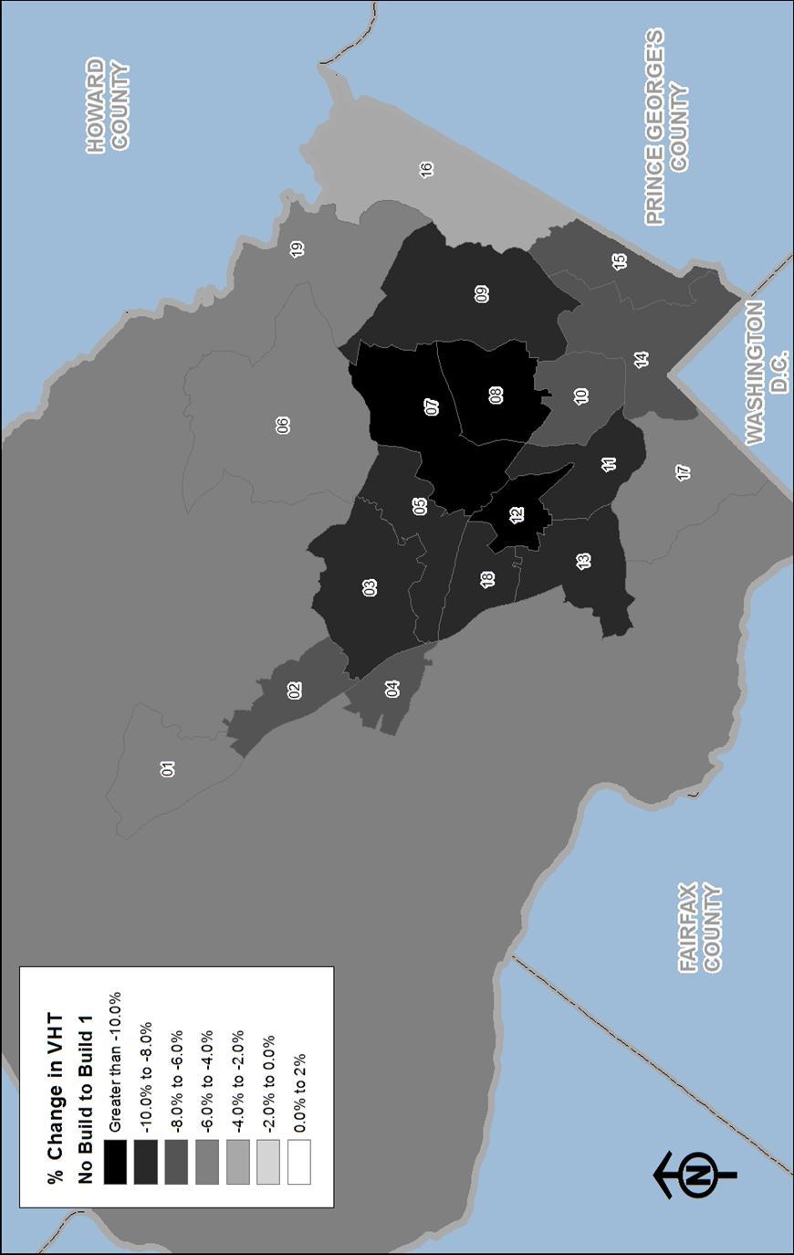
73 73
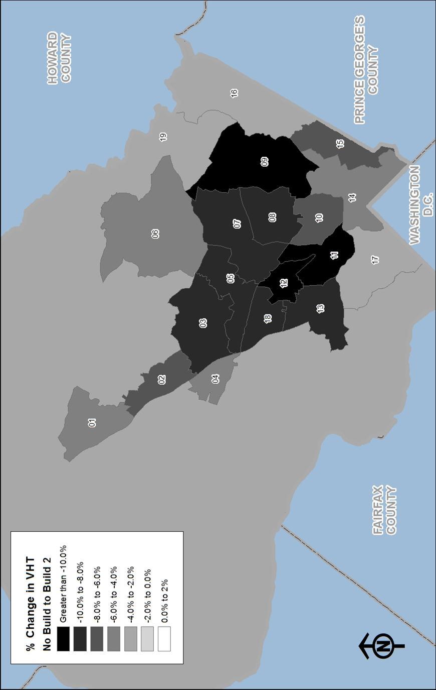
74 74
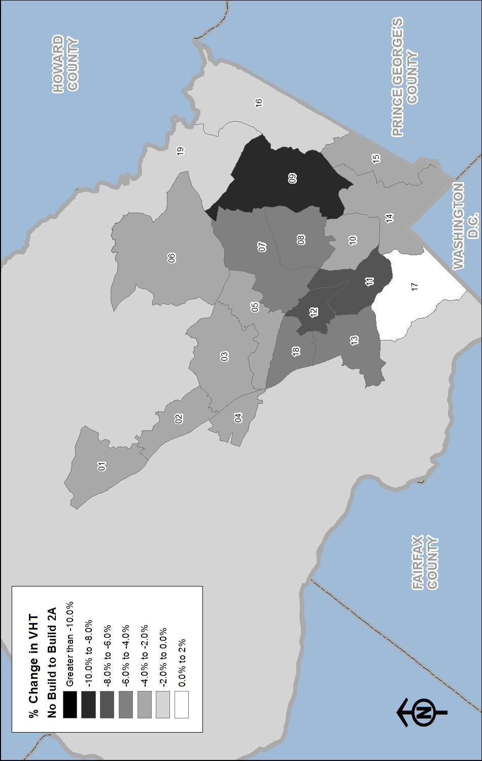
75 75
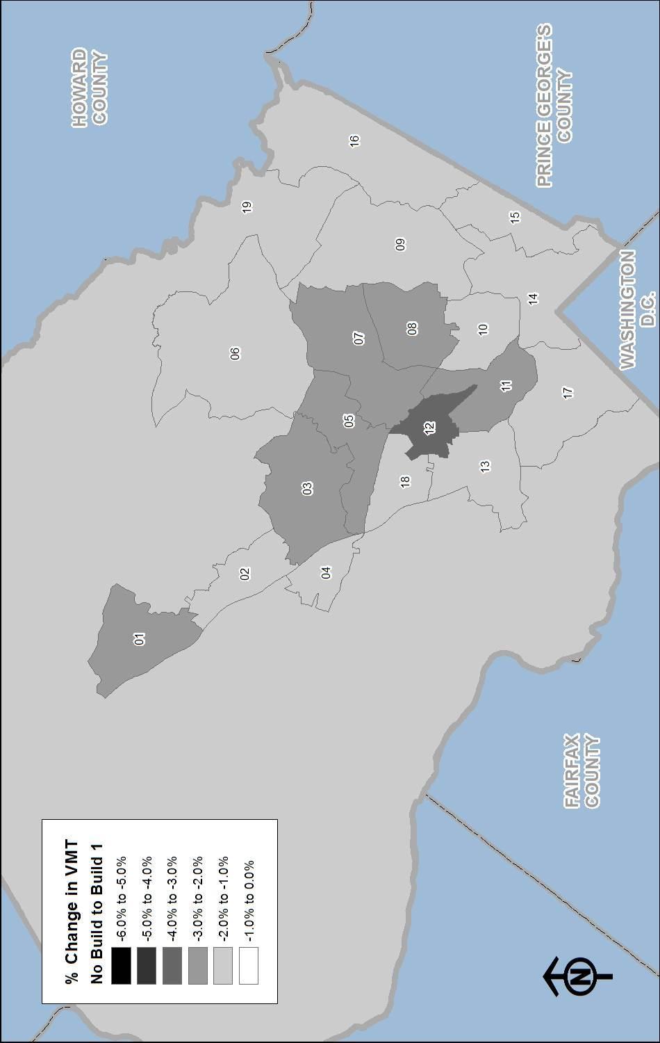
76 76
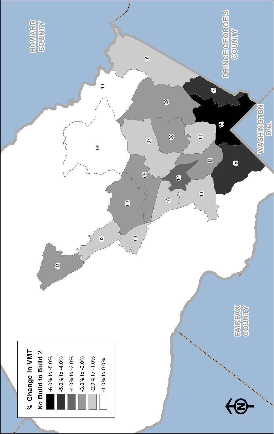
77 77
78 78
79 Plan Appendix B Corridor Descriptions The following detailed descriptions of the specific conditions in each corridor include the rationale behind the treatment recommended, as well as the recommended changes from existing master plans. Corridor 1: Georgia North The Georgia North corridor extends from the Wheaton Metrorail Station to Olney. It includes the Georgia Busway, a master planned BRT facility between Glenmont and Olney, which is currently undergoing an extensive multi-year alternatives analysis under a partnership between Montgomery County and the State of Maryland. Even under the most ambitious scenario (Build 1 and Build 2), much of the corridor is below the 1,000 pphpd threshold, though if additional land use is recommended in the ongoing Glenmont Sector Plan, the links south of Glenmont would likely see a slight increase in ridership. Ridership drops substantially with the Build 2A scenario because the portion of the corridor between Glenmont and Wheaton was tested with mixed traffic, and because other connecting corridors were also evaluated with runningway treatments that have the lower speeds associated with more curb lane and mixed traffic operations. Therefore, because this corridor has relatively good existing ridership and because it links to three other corridors that will be recommended for enhanced treatments beyond those evaluated in the Build 2A scenario, this Plan recommends including Georgia North in the transit corridor network. Table B-1 Link Ridership Forecast by Peak Hour/Peak Direction (2040) for Georgia North Corridor From To Build 1 Build 2 Build 2A Montgomery General Hospital MD 108 and MD MD 108 and MD 97 MD 97 and Hines Rd MD 97 and Hines Rd ICC Park and Ride ICC Park and Ride Park and Ride Lot - MD28 and MD Park and Ride Lot - MD28 and MD 97 MD 97 and Rossmoor Blvd MD 97 and Rossmoor Blvd MD 97 and Bel Pre Rd 1,050 1, MD 97 and Bel Pre Rd MD 97 and MD 185 1, MD 97 and MD 185 MD 97 and Hewitt Ave MD 97 and Hewitt Ave Glenmont Metro Station 1,200 1, Glenmont Metro Station MD 97 and Randolph Rd MD 97 and Randolph Rd MD 97 and Arcola Ave MD 97 and Arcola Ave Wheaton Metro Station Red = two-way median way speeds Blue = curb lane speeds Yellow = mixed traffic speeds 79
80 The Countywide Transit Corridors Functional Master Plan recommends retaining this corridor in Phase 1 as a median way because the right-of-way is available in the median for most of the corridor between Olney and Glenmont and because some of the connecting corridors are recommended for enhanced treatments that will increase their speeds over the Build 2A assumptions. Several changes to existing master plan recommendations are recommended: 1. Extend the Georgia Busway with a one-lane median reversible way between Glenmont and Wheaton to tie into the Veirs Mill and University Blvd corridors and to reflect the highly directional travel patterns in this corridor. Despite the duplication of Metrorail Red Line service in this segment, it is important from a network integrity standpoint to extend high-quality BRT service to the Wheaton Metro Station so that only a single transfer is needed to the other three transit corridors recommended in this Plan. 2. Change the current master plan recommendation from a two-lane median way to a one-lane median way between Spartan and Norbeck in the Olney Master Plan, to reflect travel patterns that are largely southbound in the morning and northbound in the evening. 3. Extend the Georgia Busway from Spartan to the planned transit center at Montgomery General Hospital. The section from Spartan to MD 108 would be a one-lane median way, while the section on MD 108 and Prince Phillip Drive would operate in mixed traffic. Table B-2 Corridor Recommendations for Georgia North From To Prince Phillip Dr Olney Sandy Spring Olney Sandy Spring Brooke Farm Drive Prince Phillip Drive Existing # of Lanes Existing Master Plan MD Phase 1 Change from Existing Master Plan ROW Lanes Treatment ROW Lanes ROW Lanes Spartan Mixed Traffic Spartan Georgia Georgia Ave MD 108 Spartan Reversible One- 200 ft south of Lane Median Georgia Ave Spartan Queen Mary Dr 200 ft south of Old Baltimore Georgia Ave Queen Mary Dr Old Baltimore Georgia Ave Emory Lane Georgia Ave Emory Lane MD Matthew Georgia Ave MD 28 Henson State Park Matthew Georgia Ave Henson State Weller Park Georgia Ave Weller Denley Reversible One- Lane Median Georgia Ave Denley Layhill Georgia Ave Layhill Randolph Georgia Ave Georgia Ave Georgia Ave Georgia Ave Randolph 500 ft south of Randolph Mason Street 400 ft north of Blueridge Ave 500 ft south of Randolph Mason Street ft north of Blueridge Ave Reedie Reedie Georgia Veirs Mill Mixed Traffic
81 Corridor 2: Georgia South In the Build 1 scenario, the Georgia South corridor was evaluated as a two-lane median way for its entire alignment between Wheaton and the DC line. The link between Wheaton and the Silver Spring Transit Center generally resulted in ridership levels that exceed the 1,000 pphpd threshold. South of the transit center, ridership levels were generally well below this threshold. Providing additional lanes for median BRT between Spring Street and the DC Line is infeasible due to right-of-way constraints and the existence of large buildings. Since there is additional capacity on 16 th Street, which runs parallel to Georgia, the Build 2 scenario converted two existing general purpose lanes to curb lanes between 16 th Street and the DC Line. This resulted in ridership that was slightly less than the Build 1 scenario. Initial evaluations show that while Georgia between Plyers Mill and Philadelphia will be heavily congested in 2040, the impacts associated with lane repurposing are minimal (see Appendix 3). In the Build 2A scenario, the Georgia South corridor was evaluated with curb lanes for its entire length. Coupled with the removal of several BRT corridors in the proposed 150-mile network and a reduction in the speed assumptions for some portions of the corridors that were retained, the ridership on this corridor dropped substantially in the Build 2A scenario. The corridor north of the Silver Spring Transit Center partially duplicates Metrorail Red Line service but retention of this segment in the network is important to maintain its integrity. Table B-3 Link Ridership Forecast by Peak Hour/Peak Direction (2040) for Georgia South Corridor From To Build 1 Build 2 Build 2A Wheaton Metro Station MD 97 and Dexter Ave 1,275 1, MD 97 and Dexter Ave Forest Glen Metro Station 1,300 1, Forest Glen Metro Station MD 97 and Seminary Rd 1,350 1, MD 97 and Seminary Rd MD 97 and Cameron St 1,300 1, MD 97 and Cameron St Silver Spring Transit Center Silver Spring Transit Center MD 97 and East-West Hwy MD 97 and East-West Hwy MD 97 and Eastern Ave Red = two-way median way speeds Blue = curb lane speeds Yellow = mixed traffic speeds Therefore, since the ridership on the Georgia South corridor will likely be somewhere between the Build 2 and Build 2A corridors, Phase 1 of the Countywide Transit Corridors Functional Master Plan recommends the following: Wheaton Station and 16 th Street: Mixed Traffic (Phase 1); Two-Lane Median (Phase 2) While there is good ridership forecast for this segment, the very high traffic volumes make it difficult to meet the lane-repurposing test. And the roadside development makes it difficult to expand the roadway without removing the off-street parking for many of the single-family homes in this segment. Given 81
82 the additional consideration of duplication of Metrorail service, we believe that it would be best to consider a median way as part of an area master plan update. 16 th Street and Colesville : Curb lanes achieved by repurposing existing lanes because: Capacity of Traffic Lane: The lane capacity in this section is estimated to be 800 vehicles per hour. Forecast Transit Ridership: The ridership is likely to be somewhere between the Build 2 and Build 2A ridership, especially when the Phase 2 recommendation between Wheaton Station and 16 th Street is included. In addition, if this segment is implemented as a curb lane way, then the local ridership would further increase ridership in the lanes. Parallel Corridor: There is excess capacity on 16 th Street for through traffic displaced from Georgia. Wayne and the DC line: This corridor segment currently accommodates MetroExtra express service to downtown Washington DC; dedicated lanes would facilitate that service in the near- to mid- term in either the median or on the curb lanes. In the long term, the District of Columbia is planning streetcar service on Georgia. Their current plan is for the line to turn at Butternut Street at the entrance to the former Walter Reed hospital and serve the Takoma Metro Station. Their consultant has recommended that the line be extended instead up to the Silver Spring Transit Center, as the Montgomery County Council has requested. Should the streetcar line be extended to Silver Spring, the repurposed travel lanes recommended by this plan could be used to facilitate that service. There are a number of issues along the portion of the corridor between Forest Glen and Wheaton that need to be resolved, including pedestrian safety issues, aesthetics, poor sidewalk and bikeway facilities. This link of the corridor is included as a two-lane median way in Phase 2 of the Countywide Transit Corridors Functional Master Plan. 82
83 Table B-4 Corridor Recommendations for Georgia South From To Georgi a Avenu e Georgi a Avenu e Georgi a Avenu e Georgi a Avenu e Georgi a Avenu e Georgi a Avenu e Georgi a Avenu e Georgi a Avenu e Wayn e Avenu e Georgi a Avenu e Georgi a Avenu e Veirs Mill Windha m Lane Dennis Forest Glen Rd I-495 Flora Lane 16th Street Spring Street Colesvill e Wayne Blair Mill Windha m Lane Dennis Forest Glen Rd Existin g # of Lanes Existing Master Plan ROW Lane s Treatme nt Phase 1 Phase 2 ROW Lanes Treatme nt Two- Mixed Lane Traffic Median I Flora Lane 16th Street Spring Street Colesvill e Georgia Blair Mill Curb Lanes Mixed Traffic Curb Lanes RO W 163 Lanes Change from Existing Master Plan Phase 1 (Phase 2) RO W 0 (+43 ) 0 (+41 ) 0 (+51 ) 0 (+51 ) 0 (+41 ) 0 (+43 ) 2 0 Lanes 0 (+2 ) 0 (+2 ) 0 (+2 ) 0 (+2 ) 0 (+2 ) 0 (+2 ) -2 gener al +2-2 gener al +2 Repurposi ng Existing Lanes? N DC Line max. 0-2 gener al +2-2 gener al +2 Y/N N N N N N N Y Y Y Y 83
84 Corridor 3: MD 355 North The MD 355 North corridor is the second highest daily ridership corridor evaluated in this Plan. For the Build 1 scenario, it was evaluated as two-lane median way, and resulted in a corridor-wide daily ridership of 34,000 riders, with ridership for most of the corridor above 1,000 pphpd, and over 2,000 pphpd south of Gaithersburg. Ridership drops slightly in the Build 2 scenario, which evaluated portions of the corridor between Ridge and Middlebrook as curb lanes. For the Build 2A scenario, the portion of the corridor north of Shakespeare Blvd was dropped because of low forecast ridership. Tying instead into the Corridor Cities Transitway (CCT) should increase the need for Phase 3 of the CCT up to Clarksburg Town Center. Under this scenario daily ridership dropped to 21,500, and the link volumes also dropped, but to levels that still warrants BRT service for most of the corridor. Table B-5 Link Ridership Forecast by Peak Hour/Peak Direction (2040) for MD 355 North Corridor From To Build 1 Build 2 Build 2A Snowden Farm Pkwy and Stringtown Rd Snowden Farm Pkwy and Foreman Blvd Snowden Farm Pkwy and Foreman Blvd Midcounty Highway and Ridge Rd Midcounty Highway and Ridge Rd MD 355 and Shakespeare Blvd Not Tested MD 355 and Shakespeare Blvd MD 355 and MD 118 1,325 1, MD 355 and MD 118 MD 355 and Middlebrook Rd 1,500 1, MD 355 and Middlebrook Rd MD 355 and Professional Dr 1,825 1, MD 355 and Professional Dr MD 355 and MD 124 2,000 1, MD 355 and MD 124 MD 355 and Odendhal Ave 2,075 1,925 1,000 MD 355 and Odendhal Ave MD 355 and Brookes Ave 2,275 2,125 1,075 MD 355 and Brookes Ave MD 355 and Education Blvd 2,125 1,975 1,200 MD 355 and Education Blvd MD 355 and Shady Grove Rd 2,500 2,325 1,500 MD 355 and Shady Grove Rd MD 355 and King Farm Blvd 2,450 2,275 1,450 MD 355 and King Farm Blvd MD 355 and Gude Dr 2,275 2,100 1,200 MD 355 and Gude Dr MD 355 and Mannakee St 2,250 2,075 1,175 MD 355 and Mannakee St Rockville Metro Station (west entrance) 2,325 2,150 1,250 Average Daily Ridership (entire corridor) 34,100 32,475 21,550 Red = two-way median way speeds Blue = curb lane speeds Yellow = mixed traffic speeds 84
85 The recommended treatments will increase intended speeds to achieve ridership levels closer to the Build 2 scenario than the Build 2A scenario by recommending a two-lane median way. While ridership will increase, it will not reach Build 2 because the incentive to take transit was reduced for many potential passengers when other corridors were dropped from the network. The Countywide Transit Corridors Functional Master Plan recommends including this corridor in Phase 1 as a two-way median way in Montgomery County because of the high ridership potential. Phase 1 recommends lane repurposing in two segments: Game Preserve to the Corridor Cities Transitway lane repurposing is recommended because BRT is anticipated to provide greater person-throughput. 1,000 feet south of Indianola to 270 feet north of North Campus Drive lane repurposing is recommended because traffic congestion will still be within an acceptable range. Just south of O Neill Drive to 1,250 feet south of Shady Grove lane repurposing is recommended because BRT is anticipated to provide greater person-throughput. In Phase 2 of this plan the entire corridor is recommended to be a two-way median way. This includes the segments in Rockville and Gaithersburg that are shown as mixed traffic in Phase 1. 85
86 Table B-6 Corridor Recommendations for MD 355 North From To Seneca Meadows Pkwy Shakespea re Boulevard MD 355 MD 355 MD 355 MD 355 MD 355 MD 355 MD 355 MD 355 Corridor Cities Transitwa y Observati on Drive Shakespea re Boulevard Game Preserve Just south of O'Neil Drive 1250 ft south of Shady Grove Rd Ridgemon t Indianola 1000 ft south of Indianola 270 ft north of N. Campus Dr Observati on Drive Existi ng # of Lanes Existing Master Plan RO W Lane s Treatme nt Phase 1 Phase 2 RO W 130 Game Preserve Just south of O'Neil Drive 1250 ft south of Shady Grove Rd Ridgemon t Indianola 1000 ft south of Indianola 270 ft north of N. Campus Dr Church Street Lanes Treatme nt Two- MD Lane Median 123 Two- Lane Median RO W Lane s Change from Existing Master Plan Phase 1 (Phase 2) RO W Lanes Repurposi ng Existing Lanes? Phase 1 (Phase 2) 6 Gaithersburg Mixed Traffic* Gaithersburg N Two- Lane Median (+11 ) - 2 gener al +2 (+2 ) 6 Rockville Mixed Traffic* Rockville N Mixed Traffic (+43 ) - 2 gener al +2 (+2 ) 6 Rockville Mixed Traffic* Rockville N Two- Lane Median (+11 ) - 2 gener al +2 (+2 ) 6 Rockville Mixed Traffic* Rockville N * 2040 forecast ridership for the segments of MD355 within the Cities of Rockville and Gaithersburg warrants a two-lane median way as part of the Phase 1 transit corridor network, however this Functional Plan cannot make changes or require dedication within those jurisdictions. Therefore, the median way is shown as a Phase 2 improvement, which would become effective upon master plan changes made by those jurisdictions. Y/N N N Y (N) Y (N) Y (N) Y (N) 86
87 Corridor 4: MD 355 South The MD 355 South corridor has the highest daily ridership forecast for any corridor evaluated in this Plan. For the Build 1 scenario it was evaluated as two-lane median way, and resulted in a corridorwide daily ridership of 49,000 riders, with ridership above 1,500 pphpd throughout, and over 2,000 pphpd between the Rockville and Medical Center Metrorail stations. Ridership drops slightly in the Build 2 scenario, which evaluated the corridor south of Cedar Lane as curb lanes to reflect right-of-way impacts. For the Build 2A scenario, the portion of the corridor south of the Grosvenor Metrorail station was evaluated as curb lanes. Overall, the corridor s ridership forecast was only slightly impacted, perhaps because some of riders switched to the MD 355 South corridor when the Old Georgetown South corridor was removed in the Build 2A scenario. This remains the highest performing corridor. Table B-7 Link Ridership Forecast by Peak Hour/Peak Direction (2040) for MD 355 South Corridor From To Build 1 Build 2 Build 2A Rockville Metro Station (west entrance) MD 355 and Edmonston Dr 1,975 1,800 1,425 MD 355 and Edmonston Dr MD 355 and Halpine Rd 2,100 1,825 1,450 MD 355 and Halpine Rd MD 355 and Hubbard Dr 2,375 2,075 1,725 MD 355 and Hubbard Dr White Flint Metro Station 2,200 1,925 1,550 White Flint Metro Station MD 355 and Security Ln 2,275 2,100 2,225 MD 355 and Security Ln Grosvenor Metro Station 2,050 1,875 2,100 Grosvenor Metro Station MD 355 and Pooks Hill Rd 2,125 1,950 2,000 MD 355 and Pooks Hill Rd MD 355 and Cedar Ln 2,075 1,925 1,975 MD 355 and Cedar Ln Medical Center Metro Station 2,000 1,825 1,900 Medical Center Metro Station MD 355 and Cordell Ave 1,875 1,750 1,775 MD 355 and Cordell Ave Bethesda Metro Station 1,825 1,700 1,775 Bethesda Metro Station Bradley Blvd and MD 355 1,675 1,400 1,125 Bradley Blvd and MD 355 Friendship Heights Metro 1,550 1,450 1,175 Average Daily Ridership (entire corridor) 48,750 46,025 43,875 Red = two-way median way speeds Blue = curb lane speeds Yellow = mixed traffic speeds 87
88 Much of this corridor duplicates existing Metrorail service on the Red Line, but we believe that this corridor retains importance for several reasons. Impact on the Red Line: While the Red Line ridership drops by between 14,000 and 23,000 riders, this only represents between 25 percent and 32 percent of BRT ridership on the Georgia and MD 355 South corridors. The ridership on these corridors is overwhelmingly new transit patrons. Additional Stations: There are potential stations areas in between Red Line stations, including White Flint Mall, Pooks Hill, Cedar Lane, Woodmont Triangle, and Bradley Boulevard. Connectivity: BRT to Bethesda provides a direct connection to the Purple Line, eliminating one transfer. Table B-8 Red Line Ridership Reduction as Percent of MD 355 and Georgia Ave BRT Ridership Corridor Build 1 Build 2 Build 2A MD 355 South 48,700 46,000 43,900 Georgia North/South 24,300 23,700 12,300 Red Line Reduction 23,100 21,700 13,900 Red Line Reduction as % of BRT 32% 31% 25% Therefore, because of the high ridership potential for this corridor, the moderate impact on the Red Line, connectivity to the Purple Line, and the potential for new stations, Phase 1 of the Countywide Transit Corridors Functional Master Plan includes the MD 355 South corridor as follows: Two-lane median way from Church Street to Bradley Blvd to accommodate the large ridership forecasts. The portion of the corridor between Church Street and just south of Hubbard Street is in the City of Rockville and will need to be included in Rockville s ongoing master plan update. We envision retaining a typical section consistent with the White Flint I Sector Plan. The portion of the corridor between just south of Hubbard Street and Bou will be the subject of the White Flint 2 Sector Plan and the two-way median way should be incorporated into this functional plan through the sector plan. We envision retaining a typical section consistent with the White Flint Sector Plan. From Bou to Hillery Way: Retain the White Flint Sector Plan typical section. From Hillery Way to I-495: Implement a two-way median way. Two-lane median way from I-495 to Bradley Boulevard This portion of the corridor has constrained right-of-way and the way should be implemented by repurposing two existing traffic lanes to the way. Lane repurposing is justified because the forecast transit volumes between the Bethesda and Grosvenor Metrorail stations exceeds the lane capacity. For the portion of the corridor south of Bradley Boulevard, implement curb lanes. This portion of the corridor had lower ridership than the rest, but if coordinated with District of Columbia traffic and operations, a two-way median way could be feasible. Phase 2 of the Countywide Transit Corridors Functional Master Plan would replace the curb lanes south of Bradley Blvd with a two-way median way. 88
89 Table B-9 Corridor Recommendations for MD 355 South To From Existing # of Lanes Existing Master Plan Phase 1 Phase 2 Change from Existing Master Plan Phase 1 (Phase 2) Repurposing Existing Lanes? Phase 1 (Phase 2) ROW Lanes Treatment ROW Lanes Treatment ROW Lanes ROW Lanes Y/N MD 355 MD 355 MD 355 MD 355 MD 355 MD 355 MD 355 MD 355 MD 355 MD 355 MD 355 MD 355 MD 355 MD 355 MD 355 MD 355 MD 355 MD 355 Church Street Halpine Twinbrook Pkwy Bou Just south of Hubbard Drive Halpine Twinbrook Pkwy Bou Just south of Hubbard Drive Rockville Mixed Traffic* Two-Lane Median Mixed Traffic Edson Lane (162)** (+29) 0 (+29) Rockville Grosvenor Two-Lane N Lane Median I N 0 (+2 ) 0 (+2 ) 150 (162)** N Edson Lane Hillery Way (162)** (162)** N Hillery Way 600 ft north of Tuckerman Ln (n) Tuckerman Lane (s) Grosvenor Lane 600 ft north of Tuckerman Ln (n) Tuckerman Lane (s) N N I-495 Cedar Lane Cedar Lane Woodmont Chestnut Street Bradley Boulevard Nottingham Drive Drummond Oliver Street Woodmont Chestnut Street Bradley Boulevard Nottingham Drive Drummond Oliver Street Somerset Terrace Curb Lanes Two-Lane Median general +2-2 general +2-2 general +2-2 general +2-2 general +2-2 general +2-2 general +2-2 general +2 N N N Y Y Y Y Y Y Y Y MD 355 Somerset Terrace Western general +2 Y * 2040 forecast ridership for the segments of MD355 within the City of Rockville warrant a two-lane median way as part of the Phase 1 transit corridor network, however this Functional Plan cannot make changes or require dedication within that jurisdiction. Therefore, the median way is shown as a Phase 2 improvement, which would become effective upon adoption of the current draft Rockville s Pike Plan or a subsequent City master plan update. ** The Rockville Pike 150-foot right-of-way can be expanded to 162 feet (additional space to be obtained through reservation). 89
90 Corridor 5: New Hampshire The Build 1 scenario evaluated a two-lane median way on the entire alignment of New Hampshire. Its daily ridership is forecast to be about 22,000 passengers. Link ridership between the Fort Totten Metro station and the Takoma/Langley Transit Center exceeded 1,600 pphpd, from the transit center to Northampton Drive it exceeds the 1,000 pphpd threshold, and generally trails off below the pphpd threshold to the north. Because the large forecast ridership south of the transit center exceeded the traffic lane capacity of the road (1,450 people), the Build 2 scenario evaluated converting two existing general purpose lanes to curb lanes. This resulted in ridership that was slightly less than the Build 1 scenario though still high enough to justify lane repurposing. Initial evaluations show that lane repurposing actually improves traffic along portions of this link, but that finding will need to be confirmed with more detailed analysis. The Build 2 scenario had a daily ridership of about 21,000 passengers, with the links to the south of Northampton Drive experiencing the highest link volumes. Build 2A evaluated way recommendations specifically based on the Build 2 ridership results. Links with ridership above 1,000 pphpd were tested as curb lanes, while links below 1,000 pphpd were tested in mixed traffic. The link to the north of US 29 was not retained due to its exceeding low (below 300 pphpd) ridership. The resulting analysis showed that these changes made what was previously a very good corridor into a marginal corridor. Therefore, the final recommendations seek to increase the speed along the corridor and add back the portion north of the White Oak Transit Center as a mixed traffic segment. 90
91 Table B-10 Link Ridership Forecast by Peak Hour/Peak Direction (2040) for New Hampshire Ave Corridor From To Build 1 Build 2 Build 2A Colesville Park and Ride Lot MD 650 and Randolph Rd MD 650 and Randolph Rd MD 650 and Valleybrook Dr MD 650 and Valleybrook Dr MD 650 and Jackson Rd Not Tested MD 650 and Jackson Rd White Oak Transit Center White Oak Transit Center FDA White Oak Campus FDA White Oak Campus MD 650 and Powder Mill Rd MD 650 and Powder Mill Rd MD 650 and Oakview Dr MD 650 and Oakview Dr MD 650 and Northampton Dr MD 650 and Northampton Dr Takoma/Langley Park Transit Center 1,125 1, Takoma/Langley Park Transit Center MD 650 and MD 410 1,600 1, MD 650 and MD 410 MD 650 and Eastern Ave 1,750 1, MD 650 and Eastern Ave Ft. Totten Metro station 1,625 1, Average Daily Ridership (entire corridor) 21,975 20,825 9,925 Red = two-way median way speeds Blue = curb lane speeds Yellow = mixed traffic speeds Therefore, because this corridor has the potential to reach high ridership levels, especially between DC and Northampton Drive, and because the segment north of US 29 provides an important source of ridership for the corridor, Phase 1 of the Countywide Transit Corridors Functional Master Plan makes recommendations for the New Hampshire corridor as follows: Provide a two-lane median way from the DC line to the Takoma/Langley Transit Center at University Blvd with lane repurposing. Lane repurposing is justified because the recommended treatments are likely to lead to ridership levels that exceed the traffic lane capacity of 1,200 persons, and to match the four lane configuration on the DC side of New Hampshire. Provide a one-lane median reversible way from Northampton Drive to the White Oak Transit Center at Lockwood Drive to reflect the highly directional travel patterns in the corridor. Retain the link from the Colesville park-and-ride to the White Oak Transit Center in the corridor as mixed traffic. While the ridership forecast on this link would not warrant BRT if it was a stand-alone corridor, it is important to retain because it will improve the corridor-wide ridership by as much as 300 pphpd, while resulting in only minimal changes to the right-of-way. Additionally, the ongoing White Oak Science Gateway Master Plan is considering substantially more land use in the vicinity of the White Oak Shopping Center and the Burnt Mills Shopping Center/Labor College site. An evaluation of the potential land use changes show that it would have a positive, though moderate impact on the ridership on the New Hampshire corridor. Combined with the 91
92 extension of BRT to the Colesville park-and-ride, the resulting ridership is likely to be closer to the Build 2 scenario then the Build 2A scenario. Table B-11 Corridor Recommendations for New Hampshire From To New Hampsh ire Ave New Hampsh ire Ave New Hampsh ire Ave New Hampsh ire Ave New Hampsh ire Ave New Hampsh ire Ave Colesville Park & Ride Randolph Lockwood Drive I-495 Northamp ton Drive University Boulevard Randolph Lockwood Drive Existi ng # of Lanes Existing Master Plan ROW Lanes Treatm ent Phase 1 Phase 2 RO W Lanes Treatm ent RO W Lan es Change from Existing Master Plan Phase 1 (Phase 2) RO W Lanes Repurpos ing Existing Lanes? Phase 1 (Phase 2) N Mixed Traffic N I Reversi ble One- 130 Lane Northamp Median ton Drive 150 University Boulevard 6 Prince George s County DC Line Two- Lane Median Mixed Traffic* Reversi ble One- Lane Median Prince George s County * 2040 forecast ridership for the segments of MD355 within Prince George s County warrant a one-lane median way as part of the Phase 1 transit corridor network, however this Functional Plan cannot make changes or require dedication within that jurisdiction. Therefore, the median way is shown as a Phase 2 improvement, which would become effective upon adoption of a subsequent master plan update gener al +2 Y/N N N N Y 92
93 Corridor 6: North Bethesda Transitway The North Bethesda Transitway has been conceived of as a spur from the Metrorail Red Line to the Rock Spring area at least as far back as 1992, when it was recommended in the North Bethesda / Garrett Park Master Plan. A study in the 1990s recommended implementing the transitway as a monorail. Starting at Montgomery Mall, it would pass through the Rock Spring area via Westlake Terrace, Fernwood and Rock Spring Drive, then head north on Old Georgetown. It heads east via the I-270 right-ofway, and emerges onto Tuckerman Lane near the North Bethesda Trail (Bethesda Trolley Trail). With the exception of Old Georgetown, much of the right-of-way is currently available through easements and dedications. There is a capital project to construct a transit center at the terminus of the transitway in Montgomery Mall. Initial ridership forecasts in the Build 1 and Build 2 scenarios found low ridership, even though the corridor was evaluated with the speeds of a two-way median transitway. The ridership potential of the corridor appeared to be negatively affected by the two Old Georgetown corridors, which overlap with portions of the North Bethesda Transitway. In Build 2A, staff therefore removed the two Old Georgetown corridors, which had marginal ridership potential, and which have challenges in regards to right-of-way. The result was a doubling of ridership on the North Bethesda Transitway. Table B-12: Link Ridership Forecast by Peak Hour/Peak Direction (2040) for North Bethesda Transitway From To Build 1 Build 2 Build 2A Montgomery Mall Transit Center Rockledge Dr and Rock Spring Dr Rockledge Dr and Rock Spring Dr Rock Spring Dr and MD ,025 Rock Spring Dr and MD 187 MD 187 and Tuckerman Ln ,050 MD 187 and Tuckerman Ln Tuckerman Ln and Sugarh Ln ,075 Tuckerman Ln and Sugarh Ln Grosvenor Metro Station ,150 Average Daily Ridership (entire corridor) 3,850 3,825 10,150 Red = two-way median way speeds Blue = curb lane speeds Yellow = mixed traffic speeds The North Bethesda Transitway creates a connection between the Metrorail Red Line and Rock Spring, and positions the transitway so that it could be expanded to Tysons Corner and the Silver Line via the I- 270 spur and I-495. Since the alignment of the transitway was identified before White Flint was envisioned as a major mixed use center, it is important to revisit the assumptions behind the transitway. The transfer point to the Red Line at the Grosvenor Metrorail Station in many ways is similar to the Fort Totten Metrorail Station. It would be a major transfer station at a rail station with relatively little land use. After the results of the Build 2A scenario were received, staff considered the merits of shifting the transfer station to one of the two Red Line stations at the end of Old Georgetown : White Flint or Bethesda. 93
94 A connection to White Flint was preferred because: The distance between the Montgomery Mall Transit Center and the proposed White Flint Metro station is about 2.7 miles whereas the distance to the Bethesda Metro station is about 4.5 miles. When the two Old Georgetown corridors were evaluated in Scenario 2, the Old Georgetown North corridor had the highest consistent ridership along Old Georgetown. (The Old Georgetown South corridor did show good ridership between Bethesda and NIH / Suburban Hospital, but the travel demand to the Rock Spring area was about half that of the Old Georgetown North corridor). If ultimately implemented as a connection to Tysons Corner, there is greater ridership potential from areas north of Grosvenor than to the south. Once White Flint was selected as a potential new terminus of the North Bethesda Transitway it was necessary to evaluate it against the existing alignment along Tuckerman to the Grosvenor station. While the distance between the two Metro stations and the Rock Spring area is the same (about 2.7 miles) there are other advantages and disadvantages of shifting the alignment to White Flint. Alignment to Grosvenor Metrorail Station: most of the right-of-way along Tuckerman Lane is currently set aside in a transitway easement. closer to Bethesda monorail may not be a viable technology, due to its high cost and the inefficiencies of a proprietary technology. If planned as a BRT route, travel along the I-270 corridor may no longer be feasible, and would likely need to be routed along a greater portion of Tuckerman Lane. Alignment to White Flint Metrorail Station: While there is only limited potential for a station along Tuckerman, a station at the intersection of Old Georgetown and Executive Blvd could support greater land use. Greater ridership potential to White Flint: when both the Old Georgetown North corridor and the original North Bethesda Transitway corridor were evaluated together, the Old Georgetown North corridor had ridership ranging from passengers on each link in Scenario 2. When the Old Georgetown North corridor was removed in Scenario 2A, the North Bethesda Transitway corridor link ridership captured 600 additional riders, increasing to 1,000 to 1,200. If the Old Georgetown North corridor was evaluated with the North Bethesda Transitway, its ridership would need to increase by only 200 to 300 riders to match the ridership of the North Bethesda Transitway in Scenario 2A. This ridership would likely come from the North Bethesda Transitway and the Old Georgetown South corridor. If the corridor is ultimately implemented as a connection to Tysons Corner, there is greater ridership potential from areas north of Grosvenor than to the south. A reversible one-lane median transitway could be implemented in a 120-foot section, the amount of right-of-way currently master-planned for Old Georgetown. Therefore, Phase 1 of the Countywide Transit Corridors Functional Plan recommends realigning the existing North Bethesda Transitway to follow the alignment of the Old Georgetown North corridor. The segment along Old Georgetown between Rockville Pike and Executive Boulevard should be implemented as a mixed traffic transitway to preserve the vision in the White Flint Sector Plan. The segment along Old Georgetown between Executive Boulevard and Rock Spring Drive should be implemented as a one-lane reversible transitway to reflect the highly directional travel patterns in this corridor. 94
95 The segment between Old Georgetown and the Montgomery Mall should be included as a two-way transitway because the right-of-way is largely available through easements. Table B-13: Corridor Recommendations for North Bethesda Transitway From To Old Georgetown Rd Old Georgetown Rd Old Georgetown Rd Old Georgetown Rd Old Georgetown Rd Rock Spring Drive Fernwood Westlake Terrace Rockville Pike Executive Boulevard Nicholson Lane Tuckerman Lane I-270 Old Georgetown Rock Spring Drive Executive Boulevard Nicholson Lane Existing # of Lanes Existing Master Plan Phase 1 Change from Existing Master Plan ROW Lanes Treatment ROW Lanes ROW Lanes Mixed Traffic Tuckerman Lane Reversible One- Lane Median I Rock Spring Drive Fernwood Rockledge Drive * * Two-Lane Side 4 80* Running 80* Rockledge Drive I * * * Plus additional 40-foot-wide easement for side-running transitway 95
96 Corridor 7: Randolph The Randolph corridor was evaluated as a two-way median way in the Build 1 and Build 2 scenarios. Ridership forecasts show a corridor with about 16,000 riders per day, but with link ridership that hovers around the 1,000 pphpd threshold. The links between Glenmont and New Hampshire Ave had the highest ridership and the links between New Hampshire and US 29 having the lowest ridership. A test was performed to evaluate the potential ridership impacts of the ongoing White Oak Science Gateway Master Plan and the Glenmont Sector Plan on this corridor. The result was a substantial increase in ridership between US 29 and Glenmont (about 500 riders per link) and a moderate increase in ridership between Glenmont and White Flint (about 250 riders per link). The daily ridership increased to about 22,000 riders. Due to limited right-of-way on Randolph and the large impacts to residential property if additional lanes were included in the master plan, Build 2A evaluated most of the corridor with the speeds of curb lanes. Along the local roads at the ends of the corridor, mixed traffic speeds were used to reflect the likelihood that additional lanes for BRT would not be provided. The results show significantly diminished ridership potential. Table B-14: Link Ridership Forecast by Peak Hour / Peak Direction (2040) for Randolph Corridor From To Build 1 Build 2 Build 2A White Flint Metro Station Randolph Rd and Lauderdale Dr Randolph Rd and Lauderdale Dr MD 586 and Randolph Rd MD 586 and Randolph Rd MD 185 and Randolph Rd MD 185 and Randolph Rd Randolph Rd and Bluhill Rd Randolph Rd and Bluhill Rd MD 97 and Randolph Rd MD 97 and Randolph Rd Glenmont Metro Station Glenmont Metro Station Glenallan Ave and Randolph Rd 1,075 1, Glenallan Ave and Randolph Rd MD 650 and Randolph Rd 1,025 1, MD 650 and Randolph Rd MD 650 and Fairland Rd MD 650 and Fairland Rd US 29 and Tech Rd US 29 and Tech Rd Industrial Pkwy and Tech Rd Industrial Pkwy and Tech Rd Industrial Pkwy and Water Tower Average Daily Ridership (entire corridor) 15,750 15,975 11,025 Red = two-way median way speeds Blue = curb lane speeds Yellow = mixed traffic speeds 96
97 Phase 1 of the Countywide Transit Corridors Functional Master Plan recommends including the Randolph corridor in mixed traffic for the following reasons: There would be substantial impacts from providing dedicated transit lanes, but this corridor has marginal ridership without a median way. Eliminating the corridor altogether will negatively impact other connecting corridors, such as Georgia Ave South. The westernmost corridor segment would serve the planned White Flint MARC commuter rail station in addition to the Metrorail station. During Facility Planning, an alternative alignment along Nebel Street rather than Parklawn Drive should be considered if the at-grade Randolph crossing of the CSX tracks is retained. Land use decisions that are made during the White Flint II Sector Plan may also affect the desirability of one alignment over the other. Phase 2 of the Countywide Transit Corridors Functional Master Plan recommends that the corridor be included as a reversible one-lane median way: The corridor shows ridership potential if implemented with a dedicated way. Travel patterns are highly directional. If the densities currently envisioned in the White Oak Master Plan and the Glenmont Sector Plan are approved, the ridership will increase substantially. Table B-15: Corridor Recommendations for Randolph From To Existing # of Lanes Existing Master Plan Phase 1 Phase 2 Change from Existing Master Plan Phase 1 (Phase 2) ROW Lanes Treatment ROW Lanes Treatment ROW Lanes ROW Lanes Randolph Rd Randolph Rd Randolph Rd Glenallen Ave Glenallen Ave Randolph Rd Randolph Rd Randolph Rd Randolph Rd Randolph Rd Parklawn Drive Nicholson Lane US 29 Paint Branch Fairland Randolph Layhill Georgia Judson Lindell Street Veirs Mill Dewey Randolph Nebel Street Paint Branch Fairland Glenallen Layhill Georgia Judson Lindell Street Veirs Mill Dewey Parklawn Drive Nebel Street 4 / Reversible 4 / One-Lane Median (+20) 0 (+20) 0 (+21) (+3) Mixed Traffic (+23) Reversible One-Lane (+21) Median 0 5 / (+21) 0 4 / (+19) 4 / MD (+1 ) 0 (+1 ) 0 (+1 ) 0 (+1 ) 0 (+1 ) 0 (+1 ) 0 (+1 ) 0 (+1 ) 97
98 Corridor 8: University Boulevard In the Build 1 and Build 2 scenarios, the Georgia South corridor was evaluated as a two-lane median way for its entire alignment. The link between Wheaton and US 29 resulted in ridership levels that exceed the 1,000 pphpd threshold. East of the US29 corridor, the forecast ridership drops. In the Build 2A scenario the segment east of Arcola was evaluated in mixed traffic and the portion to the west was evaluated as curb lanes. As a result, the ridership dropped by between 400 and 600 riders per link along the entire corridor. Table B-16: Link Ridership Forecast by Peak Hour / Peak Direction (2040) for University Blvd Corridor From To Build 1 Build 2 Build 2A Takoma/Langley Park Transit Center MD 193 and Gilbert St MD 193 and Gilbert St MD 193 and E Franklin Ave MD 193 and E Franklin Ave US 29 and MD US 29 and MD 193 MD 193 and Dennis Ave 1,050 1, MD 193 and Dennis Ave MD 193 and Arcola Ave 1,050 1, MD 193 and Arcola Ave MD 193 and Inwood Ave 1,250 1, MD 193 and Inwood Ave MD 193 and Amherst Ave 1,300 1, MD 193 and Amherst Ave Wheaton Metro Station 1,225 1, Red = two-way median way speeds Blue = curb lane speeds Yellow = mixed traffic speeds While University Blvd is not an exceedingly strong corridor, it does provide important east-west connectivity that supports the ridership along several other corridors that converge in Wheaton. Removing this corridor would negatively impact the ridership of the Veirs Mill, Georgia North, and Georgia South corridors. Therefore, this corridor is recommended to be included in the functional plan with a one-lane median reversible transitway from Georgia to Piney Branch, and then in mixed traffic between Piney Branch and New Hampshire. Permitting es to operate in the Purple Line corridor would improve BRT operations but likely have adverse operational impacts on the Purple Line that would not be justified by the relatively low ridership on this corridor. 98
99 Table B-17: Corridor Recommendations for University Blvd From To Existing # of Lanes Existing Master Plan Phase 1 Change from Existing Master Plan Repurposing Existing Lanes? ROW Lanes Treatment ROW Lanes ROW Lanes Y/N University Blvd University Blvd University Blvd University Blvd University Blvd University Blvd Georgia Ave Amherst Ave Dayton St Easecrest Dr US 29 Piney Branch Rd Amherst Ave N Dayton St Reversible N One-Lane Easecrest Median N Dr US N Piney Branch Rd New Hampshire Ave N Mixed Traffic N 99
100 Corridor 9: US 29 The Build 1 scenario was evaluated as a two-way median way. Its daily ridership was forecast to be about 18,000 riders per day, with link volumes ranging between 1,100 and 1,500 riders per day. The Build 2 scenario evaluated the corridor with a two-way median way north of the US 29/Lockwood Drive intersection. South of this intersection, it was evaluated with curb lane speeds and lane repurposing. This reduced daily ridership to about 16,500 riders per day, with link volumes between 900 and 1,300 pphpd. In Build 2A, Lockwood Drive was evaluated with mixed traffic, which further reduced ridership. A test was performed to evaluate the potential ridership impacts of the ongoing White Oak Science Gateway Master Plan and the Glenmont Sector Plan on this corridor. The result was a moderate increase in ridership along the corridor (between 100 and 200 riders per link). Table B-18: Link Ridership Forecast by Peak Hour/Peak Direction (2040) for US 29 Corridor From To Build 1 Build 2 Build 2A Burtonsville Park and Ride Briggs Chaney Park and Ride Briggs Chaney Park and Ride US 29 and Fairland Rd 1, US 29 and Fairland Rd US 29 and Tech Rd 1, US 29 and Tech Rd White Oak Transit Center 1,175 1, White Oak Transit Center Lockwood Dr and Oak Leaf Dr 1,200 1,075 1,125 Lockwood Dr and Oak Leaf Dr US 29 and Hillwood Dr 1,375 1,250 1,250 US 29 and Hillwood Dr US 29 and MD 193 1,375 1,250 1,400 US 29 and MD 193 US 29 and Franklin Ave 1,400 1,275 1,425 US 29 and Franklin Ave US 29 and Fenton St 1,450 1,325 1,475 US 29 and Fenton St Silver Spring Transit Center 1,225 1,125 1,225 Average Daily Ridership (entire corridor) 17,725 16,475 15,825 Red = two-way median way speeds Blue = curb lane speeds Yellow = mixed traffic speeds Phase 1 of the Countywide Transit Corridors Functional Master Plan recommends including this corridor as follows: A two-way median way north of Stewart Lane where the right-of-way is currently available.* Mixed traffic on Stewart Lane and Lockwood Drive because the existing roadway has only two lanes.** Curb lanes between Lockwood Drive and Southwood Drive with lane repurposing because forecast ridership exceeds lane capacity. Mixed traffic between Southwood and Sligo Creek Parkway This area experiences high traffic volumes due to vehicles entering and exiting I-495. More detailed analysis is needed to determine whether dedicated lanes can fit into the right-of-way. 100
101 Managed lanes between Sligo Creek Parkway and Georgia with lane repurposing: The sixlane roadway has lane controls to change the configuration according to the time of day: four lanes southbound and two lanes northbound during morning peak hours; two lanes southbound and four lanes northbound during evening peak hours; and three lanes in each direction during off-peak hours. Managed lanes would change this operation to have one dedicated lane in the peak direction during peak hours. Lane repurposing is justified because forecast ridership exceeds lane capacity. In addition, there is a lane drop north of Sligo Creek Parkway during peak hours in the peak direction. Curb lanes between Georgia and 16 th Street with lane repurposing. Lane repurposing is justified because in this locations because the ridership forecast on this segment exceeds the lane capacity. *During Facility Planning, the desirability of a spur connection to serve the development recommended in the White Oak Science Gateway Master Plan should be considered. **During Facility Planning, the desirability of additional accommodation on US29 through the New Hampshire interchange should also be considered to accommodate express es. Phase 2 of the Countywide Transit Corridors Functional Master Plan recommends converting Lockwood Drive and Stewart Lane to curb lanes. 101
102 Table B-19: Corridor Recommendations for US 29 From To US 29 MD 198 Stewar t Lane Lockw ood Drive Lockw ood Drive US 29 US 29 US 29 US 29 US 29 Stewart Lane New Hampsh ire Lockwo od Drive Southw ood Universi ty Bouleva rd (WB) Universi ty Bouleva rd (EB) US 29 I-495 US 29 US 29 US 29 Colesvi lle Colesvi lle Sligo Creek Parkway Spring Street Fenton Street Georgia East- West Highwa y Stewart Lane Lockwo od Drive New Hampsh ire Existi ng # of Lanes 6 Existing Master Plan ROW Lan es Treatm ent Two- Lane Median ROW Phase 1 Phase 2 Lanes Treatm ent Mixed 80 2 Curb 89 Traffic Lanes US Southw ood Universi ty Bouleva rd Universi ty Bouleva rd (EB) Curb Lanes RO W 89 Lan es Change from Existing Master Plan Phase 1 (Phase 2) RO W +61 ma x. 0 (+9 ) 0 (+9 ) 0 (+9 ) Lane s Repurpo sing Existing Lanes? Phase 1 (Phase 2) * N* * N* Mixed Traffic* I * N* Sligo Creek Parkway Spring Street Fenton Street Georgia East- West Highwa y 16th Street * N* Manag ed Lanes ** Curb Lanes 2 offpeak + 3 peak offpeak + 3 peak offpeak + 3 peak Y/N N N N N Y 0 0 Y** 0 0 Y** 0 0 Y** * Dedicated lanes are desirable in these segments and the potential for lane-repurposing to achieve curb lanes should be considered during facility planning. **The six existing general purpose lanes in these segments currently operate during peak hours as four in the peak direction and two in the off-peak direction; in off-peak hours, they operate as three lanes in each direction. This Plan recommends that the operation in peak hours be changed to one dedicated lane in the peak direction, three general purpose lanes in the peak direction, and two general purpose lanes in the off-peak direction. -2 gene ral +2-2 gene ral +2 Y Y 102
103 Corridor 10: Veirs Mill The Veirs Mill corridor is one of the corridors with the highest existing ridership in Montgomery County and has long been considered for enhancements. It is currently undergoing an extensive multi-year alternatives analysis under a partnership between Montgomery County and the State of Maryland that will recommend a BRT treatment. But because development along the corridor is low and ridership is not expected to grow significantly, this corridor does not rank among the top corridors that were evaluated. In the Build 1 and Build 2 scenarios, the corridor was evaluated as a median way and that treatment was largely retained in Build 2A, except in the vicinity of Rockville, because of Veirs Mill s importance as an east-west connector even though forecast ridership falls below what normally would warrant dedicated lanes Combined with University Boulevard corridor, the Veirs Mill corridor has an average ridership of 26,500 for Build 1 and Build 2, but this drops to about 18,000 for Build 2A. Even under the most ambitious scenario (Build 1 and Build 2) its 2040 link ridership forecasts were just below the 1,000 pphpd threshold considered necessary for inclusion in the functional plan. Under the Build 2A scenario, ridership dropped to less than half of the 1,000 pphpd threshold. Table B-20: Link Ridership Forecast by Peak Hour/Peak Direction (2040) for Veirs Mill Corridor From To Build 1 Build 2 Build 2A Wheaton Metro Station MD 586 and MD MD 586 and MD 193 MD 586 and Newport Mill Rd MD 586 and Newport Mill Rd MD 586 and MD MD 586 and MD 185 MD 586 and Randolph Rd MD 586 and Randolph Rd MD 586 and Parkland Dr MD 586 and Parkland Dr MD 586 and Aspen Hill Rd MD 586 and Aspen Hill Rd MD 586 and Twinbrook Pkwy MD 586 and Twinbrook Pkwy MD 586 and Broadwood Dr MD 586 and Broadwood Dr MD 586 and Norbeck Rd MD 586 and Norbeck Rd Rockville Metro Station (west entrance) Red = two-way median way speeds Blue = curb lane speeds Yellow = mixed traffic speeds Interestingly, the large reduction in ridership between Build 1/Build 2 and Build 2A occurs even though the evaluated treatments did not change substantially. This indicates that the Veirs Mill corridor is highly susceptible to changes on other corridors in the proposed BRT network. If other connecting corridors can be enhanced beyond the treatments evaluated in the Build 2A scenario, then the Veirs Mill corridor ridership will benefit. But because Veirs Mill is one of the few east-west corridors evaluated in the network, its removal will have a negative effect on the other corridors. Therefore, because this corridor is a link between many corridors, because it has strong existing ridership, and because some of the connecting corridors will be recommended for enhanced treatments 103
104 that will place them somewhere between the Build 2 and Build 2A ridership levels, it is recommended that this corridor be retained even though it may not be warranted as a stand-alone corridor. The Countywide Transit Corridors Functional Master Plan recommends a bi-directional one-lane median way in Phase 1, perhaps following the EmX model in Eugene, Oregon model, which relies on a single lane way with dual lanes at stations to facilitate passing. This recommendation is based on several considerations: Network Integrity: Even with low ridership, this corridor remains important because it connects the east and west sides of the county. Minimizing impacts to traffic and private property: Minimizing impacts is an important consideration for all corridors, but especially Veirs Mill, given its relatively low forecast increase in ridership over existing conditions. Therefore, a single lane rather than two lanes is desirable. No peak direction: While most corridors with low-density land use display existing travel patterns that are peak in one direction, this corridor is largely balanced in the eastbound and westbound directions. Therefore, the single median lane needs to be able to accommodate two-way travel. More than any other corridor in the recommended network, more detailed study is needed to confirm the final desired treatment for this corridor. In addition to the considerations above, this corridor is also complicated by the following factors: The typical section is highly variable both in the number of travel lanes and in the presence of service roads on one both or neither side of Veirs Mill. These service roads provide parking for single-family homes, some of which have poor alternatives for off-street parking. The differences in vertical profile between the mainline of Veirs Mill and the service roads pose challenges to creating a consistent typical section that accommodates a median way that requires roadway widening. The opening of Montrose Parkway East, whose construction is funded in the CIP, will greatly increase traffic demands on the segment of Veirs Mill between Randolph and Parkland Drive. The planned interchange at Randolph, which is directly adjacent to a commercial center and is the location of a BRT transfer station. The County/State study currently underway will provide more detailed ridership forecasts and will recommend more detailed treatments. At the conclusion of that study it may be necessary to modify the recommendations in this functional plan. 104
105 Table B-21: Corridor Recommendations for Veirs Mill From To Veirs Mill Rd Veirs Mill Rd Veirs Mill Rd Veirs Mill Rd Veirs Mill Rd Veirs Mill Rd Veirs Mill Rd Veirs Mill Rd Veirs Mill Rd Veirs Mill Rd Veirs Mill Rd Veirs Mill Rd MD 355 Meadow Hall Drive Twinbrook Parkway Parkland Drive Turkey Branch Gridley Randolph Ferrara Connecticut Newport Mill Galt Ennalls Meadow Hall Drive Twinbrook Parkway Parkland Drive Turkey Branch Gridley Randolph Ferrara Connecticut Newport Mill Galt Ennalls Wheaton Metro Station Existing # of Lanes Existing Master Plan Phase 1 Phase 2 Change from Existing Master Plan Phase 1 (Phase 2) ROW Lanes Treatment ROW Lanes Treatment ROW Lanes ROW Lanes Rockville Mixed Traffic* Reversible One-Lane Median Rockville to 6, to 6, to 6, to 6, to 6, Bidirectional One-Lane to 6, Median to 6, to 6, to 6, * 2040 forecast ridership for the segment of Veirs Mill within the City of Rockville warrants a one-lane median way as part of the Phase 1 transit corridor network, however this Functional Plan cannot make changes or require dedication within that jurisdiction. Therefore, the median way is shown as a Phase 2 improvement, which would become effective upon adoption of a subsequent City Master Plan update
106 Plan Appendix C 2040 Forecasts 106
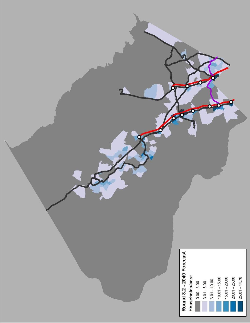
107 107
108 The Plan Process A plan provides comprehensive recommendations for the use of publicly and privately owned land. Each plan reflects a vision of the future that responds to the unique character of the local community within the context of a countywide perspective. Together with relevant policies, plans should be referred to by public officials and private individuals when making land use decisions. The STAFF DRAFT PLAN is prepared by the Montgomery County Planning Department for presentation to the Montgomery County Planning Board. The Planning Board reviews the Staff Draft Plan, makes preliminary changes as appropriate, and approves the Plan for public hearing. After the Planning Board s changes are made, the document becomes the Public Hearing Draft Plan. The PUBLIC HEARING DRAFT PLAN is the formal proposal to amend an adopted master plan or sector plan. Its recommendations are not necessarily those of the Planning Board; it is prepared for the purpose of receiving public testimony. The Planning Board holds a public hearing and receives testimony, after which it holds public worksessions to review the testimony and revise the Public Hearing Draft Plan as appropriate. When the Planning Board s changes are made, the document becomes the Planning Board Draft Plan. The PLANNING BOARD DRAFT PLAN is the Planning Board s recommended Plan and reflects their revisions to the Public Hearing Draft Plan. The Regional District Act requires the Planning Board to transmit a master plan or sector plan to the County Council with copies to the County Executive who must, within sixty days, prepare and transmit a fiscal impact analysis of the Planning Board Draft Plan to the County Council. The County Executive may also forward to the County Council other comments and recommendations. After receiving the Executive s fiscal impact analysis and comments, the County Council holds a public hearing to receive public testimony. After the hearing record is closed, the relevant Council committee holds public worksessions to review the testimony and makes recommendations to the County Council. The Council holds worksessions, then adopts a resolution approving the Planning Board Draft, as revised. After Council approval, the plan is forwarded to The Maryland-National Capital Park and Planning Commission for adoption. Once adopted by the Commission, the plan officially amends the master plans, functional plans, and sector plans cited in the Commission s adoption resolution. 108
109 ACKNOWLEDGMENTS Rose Krasnow, Interim Director Project Team Functional Planning and Policy Division Mary Dolan, Chief Tom Autrey David Anspacher Larry Cole (lead planner) Eric Graye Scott Whipple Research and Technology Division Steve Hurst Park Planning, Department of Parks Charles Kines Management Services Valerie Berton Sam Dixon Kevin Leonard Brian Kent 109


110 110
Presentation of Staff Draft March 18, 2013 COUNTYWIDE TRANSIT CORRIDORS FUNCTIONAL MASTER PLAN
 Presentation of Staff Draft March 18, 2013 COUNTYWIDE TRANSIT CORRIDORS FUNCTIONAL MASTER PLAN Public Outreach Fall 2011: Two community meetings/open houses Fall 2012: Three community meetings/open houses
Abstract. Source of Copies The Maryland-National Capital Park and Planning Commission 8787 Georgia Avenue Silver Spring, MD 20910
 1 Abstract This document contains an examination of and recommendations for transit, bicycle, and pedestrian infrastructure that will help create complete transportation options. With the approval and
Countywide Transit Corridors Functional Master Plan
 Countywide Transit Corridors Functional Master Plan Makeover Montgomery II May 10, 2014 Master Plan Status Begun: August 2011 Planning Board Approved Draft Plan: July 2013 Council Approved Final Plan:
MONTGOMERY COUNTY PLANNING DEPARTMENT THE MARYLAND-NATIONAL CAPITAL PARK AND PLANNING COMMISSION
 MONTGOMERY COUNTY PLANNING DEPARTMENT THE MARYLAND-NATIONAL CAPITAL PARK AND PLANNING COMMISSION MCPB Item No. 3 Date: 01-19-12 Worksession: Countywide Transit Corridors Functional Master Plan Larry Cole,
Chapter 7. Transportation. Transportation Road Network Plan Transit Cyclists Pedestrians Multi-Use and Equestrian Trails
 Chapter 7 Transportation Transportation Road Network Plan Transit Cyclists Pedestrians Multi-Use and Equestrian Trails 7.1 TRANSPORTATION BACKGROUND The District of Maple Ridge faces a number of unique
Proposed White Flint Separated Bike Lane Network September 2015
 Proposed White Flint Separated Bike Lane Network September 2015 Abstract This report includes a proposed separated bike lane network for the White Flint Sector Plan area. Separated bike lanes create a
MONTGOMERY COUNTY PLANNING DEPARTMENT THE MARYLAND-NATIONAL CAPITAL PARK AND PLANNING COMMISSION
 MONTGOMERY COUNTY PLANNING DEPARTMENT THE MARYLAND-NATIONAL CAPITAL PARK AND PLANNING COMMISSION MCPB Item No. 2 Date: 12-15-11 Network and Methodology Report - Countywide Transit Corridors Functional
Roadways. Roadways III.
 Introduction 97 Roadway Design Principles 98 Safe Speeds 99 Optimizing of Street Space 00 Minimum Lane Widths in the City of Boston 02 Design Features that Reduce Operating Speeds 05 Travel Lanes Transit
Regional Transportation Needs Within Southeastern Wisconsin
 Regional Transportation Needs Within Southeastern Wisconsin #118274 May 24, 2006 1 Introduction The Southeastern Wisconsin Regional Planning Commission (SEWRPC) is the official areawide planning agency
Transportation Master Plan Advisory Task Force
 Transportation Master Plan Advisory Task Force Network Alternatives & Phasing Strategy February 2016 BACKGROUND Table of Contents BACKGROUND Purpose & Introduction 2 Linking the TMP to Key Council Approved
Preliminary Transportation Analysis
 Preliminary Transportation Analysis Goals of a Robust, Multimodal Transportation Network Safe Accessible/Connected Efficient Comfortable Context-Sensitive Motor Vehicle: Continue to analyze the data to
In station areas, new pedestrian links can increase network connectivity and provide direct access to stations.
 The Last Mile Planning for Pedestrians Planning around stations will put pedestrians first. Making walking to stations safe and easy is important; walking will be a part of every rapid transit Accessible
Comments EXECUTIVE SUMMARY
 Comments 1. Under any Alternatives, MCDOT should provide better at-grade pedestrian crossing of Georgia Avenue and Forest Glen Road, including improved crosswalks with wider medians and adequate signal
MONTGOMERY COUNTY PLANNING DEPARTMENT THE MARYLAND-NATIONAL CAPITAL PARK AND PLANNING COMMISSION
 MONTGOMERY COUNTY PLANNING DEPARTMENT THE MARYLAND-NATIONAL CAPITAL PARK AND PLANNING COMMISSION MCPB Item No. 4 Date: 09-10-15 Scope of Work for the Bicycle Master Plan David Anspacher, Planner/Coordinator,
CONNECTING PEOPLE TO PLACES
 CONNECTING PEOPLE TO PLACES 82 EAST BENCH MASTER PLAN 07 Introduction The East Bench transportation system is a collection of slow moving, treelined residential streets and major arteries that are the
MONTGOMERY COUNTY COUNCIL
 MONTGOMERY COUNTY COUNCIL R O C K V I L L E, M A R Y L A N D October 20, 2015 The Honorable Isiah Leggett Montgomery County Executive 101 Monroe Street, 2nd Floor Rockville, MD 20850 Dear County Executive
Develop a Multi-Modal Transportation Strategy (Theme 6)
") DEVELOP A MULTI-MODAL TRANSPORTATION STRATEGY (THEME 6) WHY IS THIS THEME ADDRESSED? Develop a Multi-Modal Transportation Strategy (Theme 6) Statement of Ideal Reduce resident and visitor reliance on single
DEVELOP A MULTI-MODAL TRANSPORTATION STRATEGY (THEME 6) WHY IS THIS THEME ADDRESSED? Develop a Multi-Modal Transportation Strategy (Theme 6) Statement of Ideal Reduce resident and visitor reliance on single
Corpus Christi Metropolitan Transportation Plan Fiscal Year Introduction:
 Introduction: The Safe, Accountable, Flexible, Efficient Transportation Equity Act: A Legacy for Users (SAFETEA-LU) has continued the efforts started through the Intermodal Surface Transportation Efficiency
Purpose and Need. Chapter Introduction. 2.2 Project Purpose and Need Project Purpose Project Need
 Chapter 2 Purpose and Need 2.1 Introduction The El Camino Real Bus Rapid Transit (BRT) Project (Project) would make transit and other transportation improvements along a 17.6-mile segment of the El Camino
City of Gainesville Transportation/Roadway Needs PROJECT SUMMARY
 A1 Roadway Resurfacing $23,846,000 TYPE: Preservation of existing system Roadway resurfacing A2 Signal Replacement $6,000,000 TYPE: Preservation of existing system Replace traffic signals. B1 W 6th St
City of Wayzata Comprehensive Plan 2030 Transportation Chapter: Appendix A
 A1. Functional Classification Table A-1 illustrates the Metropolitan Council s detailed criteria established for the functional classification of roadways within the Twin Cities Metropolitan Area. Table
Circulation in Elk Grove includes: Motor vehicles, including cars and trucks
 Circulation, as it is used in this General Plan, refers to the many ways people and goods move from place to place in Elk Grove and the region. Circulation in Elk Grove includes: Motor vehicles, including
Providence Downtown Transit Connector STAKEHOLDER MEETING #2. Stakeholder Meeting #1 October 24, 2016
 Providence Downtown Transit Connector STAKEHOLDER MEETING #2 Stakeholder Meeting #1 October 24, 2016 February 2017 1 AGENDA 1 DTC Goals and Expectations 2 Street Design Concepts 3 Potential Benefits and
APPENDIX E BIKEWAY PRIORITIZATION METHODOLOGY
 APPENDIX E BIKEWAY PRIORITIZATION METHODOLOGY INTRODUCTION The network of bikeways recommended in the Bicycle Master Plan is extensive and is likely to be only partially completed during the 25-year life
South King County High-Capacity Transit Corridor Study
 HIGH-CAPACITY TRANSIT CORRIDOR STUDY South King County Corridor South King County High-Capacity Transit Corridor Study Corridor Report August 2014 South King County High Capacity Transit Corridor Report
5. RUNNINGWAY GUIDELINES
 5. RUNNINGWAY GUIDELINES These guidelines should be considered collectively when making runningway decisions. A runningway is the linear component of the transit system that forms the right-of-way reserved
2014 Mobility Assessment Report Functional Planning & Policy Montgomery County Planning Department
 2014 Mobility Assessment Report Functional Planning & Policy Montgomery County Planning Department Travel Trends National & Local Travel Trends Multi-Modal Monitoring Pedestrian Bikes Bus Rail Future Efforts
Chapter 5 Future Transportation
 Chapter 5 Future Transportation The Future Land Use Plan identifies the desired land use designations. The land uses desired for Crozet depend, in large part, on the success of the transportation system,
Solana Beach Comprehensive Active Transportation Strategy (CATS)
") Solana Beach Comprehensive Active Transportation Strategy (CATS) 3.0 Goals & Policies The Solana Beach CATS goals and objectives outlined below were largely drawn from the Solana Beach Circulation Element
Solana Beach Comprehensive Active Transportation Strategy (CATS) 3.0 Goals & Policies The Solana Beach CATS goals and objectives outlined below were largely drawn from the Solana Beach Circulation Element
MONTGOMERY COUNTY PLANNING DEPARTMENT THE MARYLAND-NATIONAL CAPITAL PARK AND PLANNING COMMISSION
 MONTGOMERY COUNTY PLANNING DEPARTMENT THE MARYLAND-NATIONAL CAPITAL PARK AND PLANNING COMMISSION MCPB Item No. 4 Date: 04-17-14 2014 Mobility Assessment Report José Dory, Senior Planner, Functional Planning
Multimodal Through Corridors and Placemaking Corridors
 68 Multimodal Through Corridors and Placemaking Corridors Corridors have different functions in a region. Some corridors are used to get smoothly and rapidly through a region or to get quickly to major
PURPOSE AND NEED SUMMARY 54% Corridor Need 1. Corridor Need 2. Corridor Need 3. Corridor Need 4. Corridor Need 5
 SUMMARY PURPOSE AND NEED Chapel Hill Transit ridership has increased Buses operate every 4 minutes and have standing room only Exceeding seated capacity by 12% Corridor Need 1 by more than 20 percent between
Bus Rapid Transit Plans
 Twin Cities Region Bus Rapid Transit Plans ULI Minnesota Workshop Connecting Bus Rapid Transit to the Community December 15, 2009 John Levin Director of Service Development Metro Transit Metropolitan Area
ROUTES 55 / 42 / 676 BUS RAPID TRANSIT LOCALLY PREFERRED ALTERNATIVE
 ROUTES 55 / 42 / 676 BUS RAPID TRANSIT LOCALLY PREFERRED ALTERNATIVE April, 2012 1 INTRODUCTION The need for transit service improvements in the Routes 42/55/676 corridor was identified during the Southern
Clackamas County Comprehensive Plan
 ROADWAYS The County s road system permits the movement of goods and people between communities and regions, using any of a variety of modes of travel. Roads provide access to virtually all property. They
Fitting Light Rail through Well-established Communities
 Fitting Light Rail through Well-established Communities San Francisco 2008 Michael D. Madden Chief, Project Development, Maryland Transit Administration Project Setting Located inside the Capital Beltway
SECTION 1 - TRAFFIC PLANNING
 SECTION 1 - TRAFFIC PLANNING 1.1 TRAFFIC OPERATIONS 1.1.1 Roadway Functional Classification The Multnomah County Comprehensive Framework Plan s Policy 34: Trafficways and the Functional Classification
Arlington County 10-Year Transit Development Plan & Premium Transit Network Briefing. May 2016
 Arlington County 10-Year Transit Development Plan & Premium Transit Network Briefing May 2016 Overview 10-Year Transit Development Plan Premium Transit Network Columbia Pike service concept Premium amenities
Proposed. City of Grand Junction Complete Streets Policy. Exhibit 10
 Proposed City of Grand Junction Complete Streets Policy Exhibit 10 1 City of Grand Junction Complete Streets Policy Vision: The Complete Streets Vision is to develop a safe, efficient, and reliable travel
Rapid Transit in Montgomery County
 Rapid Transit in Montgomery County Montgomery County Department of Transportation Al Roshdieh, Acting Director 1 Background Corridors in Detail Corridor Cities Transitway MD 355 (Bethesda to Rockville
PERFORMANCE ANALYSIS of The Draft 2015 CLRP
 Item 9 PERFORMANCE ANALYSIS of The Draft CLRP Presentation to the Transportation Planning Board September 16, CLRP Performance Analysis 1 What is the Long-Range Transportation Plan (CLRP)? The CLRP identifies
Durham Region Long Term Transit Strategy
 Durham Region Long Term Transit Strategy An adaptive, safe, reliable, frequent, accessible and desirable transit system that shapes and connects Durham Region and beyond in an economically and environmentally
Route 7 Corridor Study
 Route 7 Corridor Study Executive Summary Study Area The following report analyzes a segment of the Virginia State Route 7 corridor. The corridor study area, spanning over 5 miles in length, is a multi
MONTGOMERY COUNTY PLANNING DEPARTMENT
 MONTGOMERY COUNTY PLANNING DEPARTMENT THE MARYLAND-NATIONAL CAPITAL PARK AND PLANNING COMMISSION Veirs Mill Corridor Master Plan: Work Session #5 MCPB Item No. Date: 10/04/18 Jessica McVary, Planner Coordinator,
WHITE PAPER: TRANSIT SERVICE FOR SOUTH SHAGANAPPI
 9/27/2012 TRANSIT PLANNING WHITE PAPER: TRANSIT SERVICE FOR SOUTH SHAGANAPPI 2012 Calgary Transit 1 Table of Contents Purpose... 3 Area of Change... 3 Background... 3 Access to destinations... 5 Connecting
ACTIVE TRANSPORTATION
 ACTIVE TRANSPORTATION Mobility 2040 Supported Goals Improve the availability of transportation options for people and goods. Support travel efficiency measures and system enhancements targeted at congestion
Arterial Transitway Corridors Study. Ave
 Arterial Transitway Corridors Study Ave January 2012 Arterial Transitway Corridors Study Overview Corridor Features and Demographics 11 study corridors, 95 route miles 86,000 daily rides and half of existing
NM-POLICY 1: Improve service levels, participation, and options for non-motorized transportation modes throughout the County.
 Transportation PRINCE WILLIAM COUNTY 2008 COMPREHENSIVE PLAN NON-MOTORIZED PLAN CONTENTS Goals, Policies, and Action Strategies Table 4 (Bike Facility Classifications and Descriptions) Table 5 (Bike Facility
CITY OF COCOA BEACH 2025 COMPREHENSIVE PLAN. Section VIII Mobility Element Goals, Objectives, and Policies
 CITY OF COCOA BEACH 2025 COMPREHENSIVE PLAN Section VIII Mobility Element Goals, Objectives, and Policies Adopted August 6, 2015 by Ordinance No. 1591 VIII MOBILITY ELEMENT Table of Contents Page Number
TRANSIT & NON-MOTORIZED PLAN DRAFT FINAL REPORT Butte County Association of Governments
 1 INTRODUCTION Maintaining a high quality of life is the essence of this plan for transit and non-motorized transportation in Butte County. Curbing greenhouse gas emissions (GHG) by reducing congestion,
Sixth Line Development - Transit Facilities Plan
 Memorandum Date: November 13, 2012 To: From: c.c. Subject: Rob Freeman (Freeman Planning) Kevin Phillips Sixth Line Development - Transit Facilities Plan 33016631 This memo was prepared to review the transit
Exhibit 1 PLANNING COMMISSION AGENDA ITEM
 Exhibit 1 PLANNING COMMISSION AGENDA ITEM Project Name: Grand Junction Circulation Plan Grand Junction Complete Streets Policy Applicant: City of Grand Junction Representative: David Thornton Address:
Washington DC Section of ITE Project Briefing
 Washington DC Section of ITE Project Briefing November 5, 2015 Renée Hamilton, VDOT, Deputy District Administrator I-66 Outside the Beltway Improvement Area Project Location Virginia 2 Purpose and Need
North Coast Corridor:
 North Coast Corridor: Connecting People, Transportation & Environment Legislative Hearing: 11.8.10 1 North Coast Corridor Region s Lifeline A Regional Strategy Mobility, Economy & Environment North Coast
WELCOME TO OPEN HOUSE # 1 June 14, 2017
 Langstaff Road Weston Road to Highway 7 Class Environmental Assessment Study WELCOME TO OPEN HOUSE # 1 June 14, 2017 Please sign in and join our mailing list Purpose of Open House #1 & Study Area York
Southwest Bus Rapid Transit (SW BRT) Functional Planning Study - Executive Summary January 19 LPT ATTACHMENT 2.
 Functional Planning Study - Executive Summary January 19 LPT ATTACHMENT 2.") Southwest Bus Rapid Transit (SW BRT) Functional Planning Study - Executive Summary 2011 January 19 1 of 19 Introduction This executive summary presents the results of the Southwest Bus Rapid Transit (SW
Southwest Bus Rapid Transit (SW BRT) Functional Planning Study - Executive Summary 2011 January 19 1 of 19 Introduction This executive summary presents the results of the Southwest Bus Rapid Transit (SW
City of Novi Non-Motorized Master Plan 2011 Executive Summary
 City of Novi Non-Motorized Master Plan 2011 Executive Summary Prepared by: February 28, 2011 Why Plan? Encouraging healthy, active lifestyles through pathway and sidewalk connectivity has been a focus
MONTGOMERY COUNTY COUNCIL MEMORANDUM
 MONTGOMERY COUNTY COUNCIL R O C K V I L L E, M A R Y L A N D HANS RIEMER COUNCILMEMBER AT-LARGE MEMORANDUM To: T&E Committee From: Councilmember Hans Riemer Date: March 1, 2016 Re: Funding a Protected
Classification Criteria
 SCHEDULE D TO RECOMMENDED OFFICIAL PLAN AMENDMENT NO. 40 SCHEDULE C-4 Road Criteria Criteria Traffic Service Objective Land Service/Access Typical Daily Traffic Volume Flow characteristics Travel Speed
December For more information, call the Area 2 Division at (301)
") December 2013 Appendix B: Transportation Analysis For more information, call the Area 2 Division at (301) 495-4500 GLENMONT SECTOR PLAN TRANSPORTATION APPENDIX November 8, 2013 1 Contents Purpose Transportation
December 2013 Appendix B: Transportation Analysis For more information, call the Area 2 Division at (301) 495-4500 GLENMONT SECTOR PLAN TRANSPORTATION APPENDIX November 8, 2013 1 Contents Purpose Transportation
Baseline Road Rapid Transit: Bayshore Station to Prince of Wales Drive
 Baseline Road Rapid Transit: Bayshore Station to Prince of Wales Drive Planning and Environmental Assessment Study Consultation Group Meetings May 2014 Presentation Agenda Study Overview Study Progress
2.0 LANE WIDTHS GUIDELINE
 2.0 LANE WIDTHS GUIDELINE Road Engineering Design Guidelines Version 2.0.1 May 2018 City of Toronto, Transportation Services City of Toronto Page 0 Background In early 2014, Transportation Services initiated
PEDESTRIAN ACTION PLAN
 ATTACHMENT 2 CITY OF SANTA MONICA PEDESTRIAN ACTION PLAN CITY OF SANTA MONICA PEDESTRIAN ACTION PLAN This page intentionally left blank EXECUTIVE SUMMARY CHAPTER 1 EXECUTIVE SUMMARY Setting the Stage
Appendix G: Bicycle Parking Space Recommendations at Transit Stations
 Appendix G: Bicycle Parking Space Recommendations at Transit Stations Bicycle parking is needed at all Metrorail Red Line, MARC, Purple Line and Corridor Cities Transitway stations. This appendix includes
MONTGOMERY COUNTY PLANNING DEPARTMENT THE MARYLAND-NATIONAL CAPITAL PARK AND PLANNING COMMISSION
 MONTGOMERY COUNTY PLANNING DEPARTMENT THE MARYLAND-NATIONAL CAPITAL PARK AND PLANNING COMMISSION MCPB Item No. 5 Date: 12/3/15 Draft White Flint Separated Bike Lanes Network David Anspacher, Functional
Appendix A-2: Screen 1 Alternatives Report
 Appendix A-2: Screen 1 Alternatives Report SCREEN 1 ALTERNATIVES REPORT Western & Ashland Corridors Bus Rapid Transit (BRT) Project Prepared for Chicago Transit Authority 567 West Lake Street Chicago,
EUCLID AVENUE PARKING STUDY CITY OF SYRACUSE, ONONDAGA COUNTY, NEW YORK
 EUCLID AVENUE PARKING STUDY CITY OF SYRACUSE, ONONDAGA COUNTY, NEW YORK CITY OF SYRACUSE DEPARTMENT OF PUBLIC WORKS 1200 CANAL STREET EXTENSION SYRACUSE, NEW YORK 13210 DRAFT REPORT DATE: November 13,
ADOT Statewide Bicycle and Pedestrian Program Summary of Phase IV Activities APPENDIX B PEDESTRIAN DEMAND INDEX
 ADOT Statewide Bicycle and Pedestrian Program Summary of Activities APPENDIX B PEDESTRIAN DEMAND INDEX May 24, 2009 Pedestrian Demand Index for State Highway Facilities Revised: May 29, 2007 Introduction
Chapter 6 Transportation Plan
 Chapter 6 Transportation Plan Transportation Plan Introduction Chapter 6 Transportation Plan Transportation Plan Introduction This chapter describes the components of Arvada s transportation system, comprised
Bicycle Master Plan Goals, Strategies, and Policies
 Bicycle Master Plan Goals, Strategies, and Policies Mobilizing 5 This chapter outlines the overarching goals, action statements, and action items Long Beach will take in order to achieve its vision of
APPENDIX 2 LAKESHORE ROAD TRANSPORTATION REVIEW STUDY EXECUTIVE SUMMARY
 APPENDIX 2 LAKESHORE ROAD TRANSPORTATION REVIEW STUDY EXECUTIVE SUMMARY Appendix 2 City of Mississauga Lakeshore Road FINAL REPORT Transportation Review Study December 2010 EXECUTIVE SUMMARY Study Purpose
Executive Summary Route 30 Corridor Master Plan
 Route Corridor Master Plan Project Overview The Route Corridor Master Plan is a coordinated multimodal transportation and land use plan for the entire stretch of Route through East Whiteland Township,
I-105 Corridor Sustainability Study (CSS)
") I-105 Corridor Sustainability Study (CSS) Metro Streets and Freeways Subcommittee March 21, 2019 Gary Hamrick Cambridge Systematics, Inc. I-105 CSS Project History & Background Funded by Caltrans Sustainable
I-105 Corridor Sustainability Study (CSS) Metro Streets and Freeways Subcommittee March 21, 2019 Gary Hamrick Cambridge Systematics, Inc. I-105 CSS Project History & Background Funded by Caltrans Sustainable
Appendix A-K Public Information Centre 2 Materials
 Appendix A-K Public Information Centre 2 Materials Our Rapid Transit Initiative Make an impact on the future of transit Join the discussion on Rapid Transit in London You re invited to a Public Information
MCTC 2018 RTP SCS and Madera County RIFP Multi-Modal Project Eval Criteria GV13.xlsx
 MCTC 8 RTP SCS and Madera County RIFP Multi-Modal Project Eval Criteria GV.xlsx Madera County Transportation Commission Regional Transportation Plan / Sustainable Communities Strategy Multi-Modal Project
Living Streets Policy
 Living Streets Policy Introduction Living streets balance the needs of motorists, bicyclists, pedestrians and transit riders in ways that promote safety and convenience, enhance community identity, create
University Hill Transportation Study Technical Memorandum Alternatives Modeling and Analysis May 2007
 Technical Memorandum May 2007 Syracuse Metropolitan Transportation Council Edwards and Kelcey with Wallace Roberts and Todd Alta Planning and Design CONTENTS SECTION ONE- INTRODUCTION...1 SECTION TWO-
Appendix 3 Transportation Analyses For more information, call the Transportation Division at Wheaton CBD and Vicinity Sector Plan
 Appendix 3 Transportation Analyses For more information, call the Transportation Division at 301-495-4525 montgomery county planning board maryland-national capital park and planning commission Contents
Capital and Strategic Planning Committee. Item III - B. April 12, WMATA s Transit-Oriented Development Objectives
 Capital and Strategic Planning Committee Item III - B April 12, 2018 WMATA s Transit-Oriented Development Objectives Page 24 of 76 Washington Metropolitan Area Transit Authority Board Action/Information
SANTA CLARA COUNTYWIDE BICYCLE PLAN August 2008
 SANTA CLARA COUNTYWIDE BICYCLE PLAN August 2008 To assist VTA and Member Agencies in the planning, development and programming of bicycle improvements in Santa Clara County. Vision Statement To establish,
Spring Lake Park Mounds View North Oaks. Arden Hills. Shoreview. Roseville. Little Canada. Falcon Heights SNELLING. Lilydale. West Saint Paul 35E
 Coon Rapids Blaine Spring Lake Park Mounds View rth Oaks In 2011, Metro Transit embarked on the Arterial 494 Minnetonka Maple Grove Plymouth Hopkins Brooklyn Park New Hope Golden Valley Louis Park Edina
CITY OF BLOOMINGTON COMPLETE STREETS POLICY
 CITY OF BLOOMINGTON COMPLETE STREETS POLICY POLICY OBJECTIVE: The City of Bloomington will enhance safety, mobility, accessibility and convenience for transportation network users of all ages and abilities,
EXECUTIVE SUMMARY OF CALEDON TRANSPORTATION NEEDS STUDY
 EXECUTIVE SUMMARY OF CALEDON TRANSPORTATION NEEDS STUDY The Caledon Transportation Needs Study has been undertaken as a joint project by the Town of Caledon and the Region of Peel to determine the existing
Prepared For: Shieldbay Developments Inc. c/o Matson, McConnell Ltd. 2430A Bloor Street West Toronto, Ontario M6S 1P9.
 Prepared For: Shieldbay Developments Inc. c/o Matson, McConnell Ltd. 2430A Bloor Street West Toronto, Ontario M6S 1P9 Prepared By: URS Canada Inc. 4 th Floor, 30 Leek Crescent Richmond Hill, Ontario L4B
Multimodal Approach to Planning & Implementation of Transit Signal Priority within Montgomery County Maryland
 Multimodal Approach to Planning & Implementation of Transit Signal Priority within Montgomery County Maryland A Path to Successful Implementation James Allday Bunch - Sabra, Wang & Associates, Inc. ITS
Perryville TOD and Greenway Plan
 Perryville TOD and Greenway Plan Greenway Glossary Pathway: A bicycle and pedestrian path separated from motorized vehicular traffic by an open space, barrier or curb. Multi-use paths may be within the
Agenda. Overview PRINCE GEORGE S PLAZA METRO AREA PEDESTRIAN PLAN
 PRINCE GEORGE S PLAZA METRO AREA PEDESTRIAN PLAN May 28, 2008 Agenda Welcome and introductions Project overview and issue identification Planning context and strengths Design challenges and initial recommendations
Implementing Complete Streets in Ottawa. Project Delivery Process and Tools Complete Streets Forum 2015 October 1, 2015
 Implementing Complete Streets in Ottawa October 1, 2015 The Essentials Complete Streets Implementation Framework will become part of the routine delivery of City transportation projects Approach uses every
Moving Cambridge. City of Cambridge Transportation Master Plan Public Consultation Centre. March 7, :00 8:00 PM.
 City of Cambridge Transportation Master Plan Public Consultation Centre March 7, 2018 5:00 8:00 PM Region of Waterloo City of Cambridge Transportation Master Plan Public Consultation Centre March 7, 2018
CPC Parking Lot Riverside Drive. Transportation Rationale
 CPC Parking Lot Transportation Rationale Prepared By: NOVATECH Suite 200, 240 Michael Cowpland Drive Ottawa, Ontario K2M 1P6 September 2015 Novatech File: 114093 Ref: R-2015-153 Table of Contents 1.0 INTRODUCTION...
Planning Guidance in the 2012 AASHTO Bike Guide
 Planning Guidance in the 2012 AASHTO Bike Guide Presentation by: RJ Eldridge Peter Lagerwey August 22, 2012 WEBINAR 2: PLANNING GUIDANCE IN THE 2012 AASHTO BIKE GUIDE Today s Webinar Significant Updates
2. Context. Existing framework. The context. The challenge. Transport Strategy
 Transport Strategy Providing quality connections Contents 1. Introduction 2. Context 3. Long-term direction 4. Three-year priorities 5. Strategy tree Wellington City Council July 2006 1. Introduction Wellington
FY2006 Budget Board Budget Committee request for information. Board Request: Detailed information on bus route 5A DC-Dulless Airport
 Board Request: Detailed information on bus route 5A DC-Dulless Airport Tracking Number: 29 Assigned to Dept/Office: OPER Contact Person: Jim Hughes Metrobus Route 5A was established in December 2000 in
Scottsdale Road/Rural Road Alternatives Analysis (AA) Study. Arizona ITE/IMSA Spring Conference March 7, 2012
 Study. Arizona ITE/IMSA Spring Conference March 7, 2012") Scottsdale Road/Rural Road Alternatives Analysis (AA) Study Arizona ITE/IMSA Spring Conference March 7, 2012 Study Location and Duration Primary Study Corridor (major focus of effort) Rural Road and Scottsdale
Scottsdale Road/Rural Road Alternatives Analysis (AA) Study Arizona ITE/IMSA Spring Conference March 7, 2012 Study Location and Duration Primary Study Corridor (major focus of effort) Rural Road and Scottsdale
Active Transportation Facility Glossary
 Active Transportation Facility Glossary This document defines different active transportation facilities and suggests appropriate corridor types. Click on a facility type to jump to its definition. Bike
APPENDIX A: Complete Streets Checklist DRAFT NOVEMBER 2016
 APPENDIX A: Complete Streets Checklist DRAFT NOVEMBER 2016 Complete Streets Checklist MetroPlan Orlando s Complete Streets Checklist is an internal planning tool for staff to further implementation of
Tulsa Metropolitan Area LONG RANGE TRANSPORTATION PLAN
 Tulsa Metropolitan Area LONG RANGE TRANSPORTATION PLAN Indian Nations Council of Governments August 2005 CONTACTING INCOG In developing the Destination 2030 Long Range Transportation Plan, INCOG s Transportation
4. ENVIRONMENTAL IMPACT ANALYSIS 9. TRANSPORTATION AND TRAFFIC
 4. ENVIRONMENTAL IMPACT ANALYSIS 9. TRANSPORTATION AND TRAFFIC 4.9.1 INTRODUCTION The following section addresses the Proposed Project s impact on transportation and traffic based on the Traffic Study
ALTERNATIVES ANALYSIS EXECUTIVE SUMMARY
 West Valley Connector Corridor ALTERNATIVES ANALYSIS EXECUTIVE SUMMARY FINAL September 2014 Ontario International Airport Ontario Mills Rancho Cucamonga Metrolink Station Kaiser Permanente PARSONS EXECUTIVE
Corridor Advisory Group and Task Force Meeting #10. July 27, 2011
 Corridor Advisory Group and Task Force Meeting #10 July 27, 2011 1 Agenda Recap CAG/TF #9 Public Meeting #2 Summary Single Mode Alternatives Evaluation Results Next Steps 2 3 CAG/TF #9 Recap CAG /TF #9