M Street SW-Southeast Federal Center
|
|
|
- Everett Payne
- 5 years ago
- Views:
Transcription
1 Section 1 M Street SW-Southeast Federal Center
2 1 2
3 M Street SW M Street SW and the Southeast Federal Center, located in Southeast and Southwest Washington, DC, comprise an activity center area that is an established employment center with some dense residential blocks within it. It can be characterized as an extension of the downtown core. There is a high concentration of employment, housing and future retail and entertainment uses. The center is served by several modes of transit including Metrorail, Metrobus, and commuter bus. Other center highlights: Extensive programmed growth in the immediate future and is already a booming employment center; the employment density is second only to downtown Washington. GSA and Navy have TDM programs that can be leveraged. Mixed-income residential communities nearby. Metrorail stations and bus connections to be improved to accommodate planned redevelopment along M Street SE. Potential to increase ridership and potential for ease of implementation with federal partner. The center is characterized by poorly maintained, vandalized, and unkempt bus stops within a well-traveled corridor that is undergoing redevelopment. The study area is bounded by the Navy Yard on the east end and the Waterfront on the west. While there is some high- and medium-density residential along M Street, the majority of land uses are office and light industrial. Using the best available data from the 2000 census, there were 7,800 households in the study area and 12,000 jobs. With the move of 4500 more staff to the Navy Yard (raising the total to over 11,000), the start of construction of the SE Federal Center adjacent to it, and the construction of a new US Department of Transportation headquarters, there has been an increase in development of office construction to house businesses that serve those governmental agencies. The District Government would like to encourage the continued redevelopment of the large industrial lands to the south of M Street in conjunction with its ambitious Anacostia Waterfront Initiative. 1 3
4 Significant activity in the area relates to reconstruction of public housing at Arthur Capper-Carrollsburg, construction of USDOT and other offices, planning related to Waterfront revitalization, and refurbishment of South Capitol Street. This development, including the construction of a ballpark, a significant regional destination, in the study area underscores the need to meet growing demand with flexible, useful transit service. See Figure 1-1 for an aerial view of the study area. Census data from 2000 demonstrates that home end transit mode share for the study area edges out driving alone slightly. Home and work end mode share for the study area are shown in Table 1-1. Table 1-1 M Street Mode Share Home End Work End Transit Drive Alone Walk/Bike Transit Drive Alone Walk/Bike M Street 40% 36% 19% 19% 58% 4% Source: 2000 Census Transportation Planning Package 1 4

5 Figure 1-1 M Street SW/Southeast Federal Center Land Use Waterfront Mall & Office Navy Yard Metro Waterfront Metro SE Federal Center Navy Yard 1 5

6 Transportation System Characteristics While traffic congestion on M Street is heavy during peak periods, on the various observation days travel times did not vary as much as had been anticipated. Traffic congestion on M Street is centered near the South Capitol Street intersection. Traffic build-up lessens as cars travel away from the intersection in either direction. There is a heavy volume of pedestrian traffic in and around the Waterside Mall area, and along M street from the Navy Yard to the Metrorail station. Diamond lanes exist eastbound between Canal Street SW and South Capitol Street, and westbound between 5th Street SW and South Capitol Street SW. Volume during peak hour traffic was moderate without any real congestion concerns. Pedestrian Environment There is a high volume of pedestrian activity in the study area, specifically during the morning and evening peak and the lunch hour, concentrated on M Street. Although there is a consistent network of sidewalks in the study area, in keeping with its urban setting, construction activities have disrupted some of the sidewalks. The Navy Yard Metrorail station is a five-minute walk, approximately, from the current office buildings, including the new USDOT headquarters under construction, and one entrance to the Navy Yard. However, there are relatively few signalized pedestrian crossings. The crossing at the Metrorail entrance, while distinguished with distinctive paving, does not have a signal. During times of heavy pedestrian activity, jaywalking and walking along the median are common. Even during off-peak hours, pedestrians have a significant wait to cross M Street, encouraging many to cross against traffic, especially to catch buses. Additionally, although the Navy Yard is within what is generally considered an acceptable walking distance, less than a quarter-mile, the more distant portions of the Yard are a considerable walk. There are very few pedestrian amenities, and no benches, trees, or planters buffering pedestrians from traffic along M Street. There are benches and bike racks at the Navy Yard Metrorail entrance at New Jersey Avenue, but during each observation period (morning, midday, afternoon, and evening) the bike racks were not in use and the benches were occupied by transients. 1 6

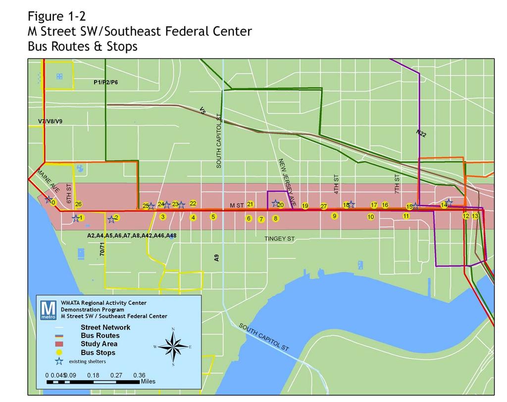
7 Transit Facilities and Operations Transit services include two Metrorail stations, three Metrobus routes on M Street, and three Metrobus routes that cross M Street, and several MTA routes. Maritime Plaza runs its own shuttle from the Navy Yard Metrorail station to the Navy Yard that is able to enter the Navy Yard because the riders are from a pre-cleared group, identified before boarding. The Department of Defense began running a shuttle from Crystal City after relocating several thousand employees to the Navy Yard. There are two Metrorail stations along M Street: Waterfront on the west end and Navy Yard on the east. There are 27 bus stops along M Street between 7th Street SW and 12th Street SE, as shown in Figure 1-2. Of those, 12 have shelters. Transit information is posted at many stops, but usually is not complete. Effective dates of the schedules are not shown, so whether the schedules are up-to-date is not known. The bus stops at the Navy Yard Metrorail station do not have shelters or schedules. A large number of the bus stops along M Street have been vandalized, with the majority of shelters missing glass panels. Trash and graffiti cover many shelters, with poor landscaping and unkempt surroundings. Streetscape improvements, with improved bus shelters and surroundings, have been made in a few locations on the east end as part of recent redevelopment. WMATA operates six bus lines through the study area, with several routings. Bus lines and routings within the study area are shown in Table 1-2 and Figure
8 WMATA Table 1-2 Existing Bus Service within the M Street Study Area Headway Peak Off-Peak Line N22 - Navy Yard Shuttle Line Union Station/Eastern Market/Navy Yard 9 18 Line P1/2/6 - Anacostia-Eckington Line Line P1/2 - Anacostia/Navy Yard/SW Federal Center/Archives Line P6 - Anacostia/Navy Yard/Archives Line P17/18/19 - Oxon Hill-Fort Washington Line runs along S. Capital St. Line V7/8/9 - Minnesota Ave-M Street Line Potomac Ave Metro/Navy Yard/Waterfront Mall/L'Enfant Metro 8 30 Line 70/71 - Georgia Ave.-7th Street Line L'Enfant Metro/Waterfront Mall/ M St. SW MTA Commuter Bus Routes 901 La Plata/Waldorf Washington, D.C Trip 902 St. Leonard/Prince Frederick Washington, D.C Trip 903 Charlotte Hall/Waldorf Washington, D.C. 30 None 904 Pindell/North Beach Washington, D.C Trip 905 Charlotte Hall/Waldorf Washington, D.C Trip 907 La Plata/Waldorf Washington, D.C. 20 None 909 California/Charlotte Hall Washington, D.C. 30 None 915 Columbia/Silver Spring Washington, D.C. Varies None 922 Annapolis Washington, D.C. Varies None 929 Columbia Silver Spring/Washington, D.C Trip 1 8
9 1 9
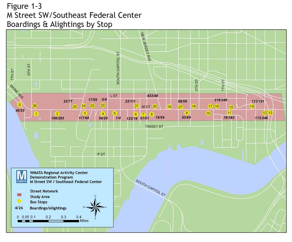
10 Transit Ridership The heaviest bus passenger volumes in the study area occur at the Navy Yard Metrorail and at the multiple entrances to the Navy Yard proper. Other highvolume stops include the office development on the north side of M Street across from the future USDOT building and the SW business development at Delaware Avenue. Figure 1-3 shows daily weekday ridership at each stop in the study area and Table 1-3 shows total ridership by bus route that serve the M Street study area, including the ridership for MTA commuter bus routes which have stops in the study area (either the Navy Yard directly or Capitol Hill). Table 1-3 Ridership by Route Metrobus Route Average Weekday Ridership AM Peak Riders 5:30 AM - 9:29 AM PM Peak Riders 3:00 PM - 6:59 PM Percentage of Daily Riders during Peak Check Date N22 Northbound % Jan-03 N22 Southbound % Jan-03 P1,2,6 Northbound 2, % Jan-00 P1,2,6 Southbound 2, % Mar-01 P17,18,19 Northbound NA 84% May-01 P17,18,19 Southbound 514 NA % May-01 V7,8,9 Eastbound 2, ,261 68% May-01 V7,8,9 Westbound 2,768 1, % May-01 70,71 Northbound 8,332 1,693 2,671 52% Jan-99 70,71 Southbound 7,700 1,700 2,320 52% Jan-99 MTA Commuter Bus Route Average Weekday Ridership Average Boardings/ Trip 901 1, ,
11 Rail ridership for the Metrorail stations in the M Street study area, Navy Yard and Waterfront, is shown in Table 1-4. Table 1-4 Rail Ridership, Trip Purpose, and Mode of Access by Station Ridership AM Peak PM Peak Daily Total Navy Yard 530 1,416 6,016 Waterfront 1,225 1,385 3,814 Reason for Work Home Trip Navy Yard 35% 5% Waterfront 30% 50% Mode Access Metrobus Other Bus Walk Bike Auto Dropped Off Navy Yard 3% <1% 43% 0% 3% 3% Waterfront 3% 1% 88% <1% 3% 2% 1 11
12 1 12
13 Needs and Opportunities The M Street Corridor is heavily serviced by transit, but given the physical and operational limitations on the pedestrian circulation network, it is likely that this issue may be the most critical in terms of improving transit usage. Future plans call for still more dense development, and it is possible that with the redevelopment of the Southeast Federal Center, the completion of the new USDOT headquarters, and the construction of a new regional ballpark just off the corridor, the demand for transit service will increase considerably. Covering the basics, ensuring that shelters are maintained, transit information is accurate, and service covers the necessary time-span for the corridor, will be critical. During field work and stakeholder reviews for this demonstration program, the following significant needs were identified: Capital Improvements Bus shelters throughout the study area were in poor condition during each field observation. Some of these were the shelters installed by a federal agency in conjunction with the transfer of federal employees to the area. However, currently no agency claims ownership/responsibility for the shelters, and they are not maintained. Putting shelters at high-volume stops and ensuring that they and existing shelters are properly maintained is a significant corridor need. While the Navy Yard station has a clearly visible entrance the Waterfront station entrance is difficult to see from the street, and pedestrians must walk through a parking lot to enter. The sidewalk on the south side of M Street is too narrow for shelters. In addition, pedestrian circulation along M Street is hampered by physical conditions, namely narrow sidewalks, few signalized crossings, and a wall. During every period of observation, jaywalking was a regular practice. During the afternoon and morning peak periods, mid block crossings, using medians as a pedestrian path, and groups of waiting transit passengers blocking the path of other pedestrians, were significant. Transit Operational Issues The N22 shuttle, which operates between Union Station and the Navy Yard Metrorail station via Eastern Market Metrorail station, used to enter the Navy Yard. Ridership significantly reduced when the N22 was no longer allowed to enter Navy Yard after 9/11. While the Navy Yard Metrorail is within walking distance of the Navy Yard entrance, the southeastern portion of the Yard is more than 1/2 mile walking distance, apparently beyond the means of many potential transit riders. The District of Columbia Government wants to extend N22 to M Street SW, to serve redevelopment there. 1 13


14 A downtown circulator is proposed to operate down 7th Street SW to Waterfront. One option to consider is to combine that route with the N22 to make a complete circuit. Currently, the Union Station N22 extension serves Eastern Market, Barracks Row, and general Capitol Hill traffic. It has good schedule reliability, due to its short route, but could serve the area better with increased headways. Apart from this concern, no serious operational issues were observed other than the normal traffic congestion for an urban area with many traffic signals. The proposal to remove the grade-separation of South Capitol Street with M Street is of concern, as the traffic volume on South Capitol is quite high. 1 14
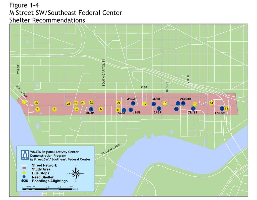
15 Recommended Actions With the understanding that transit ridership in the M Street area was relatively high, given the already high-level of transit service in the corridor and dense concentration of employment, the recommended actions for the M Street area lean more toward the supportive policy side. Low-cost service improvements are unlikely to make much a dent in transit ridership in the area. Rather, given the projected redevelopment and greater density for the area in the coming few decades, a new mode, such as bus rapid transit or streetcar, with a higher capital cost and longer project development horizon than was considered appropriate for this demonstration program, is likely to be both necessary and desirable. Proposed Bus Service and Capital Enhancements Service Extend Navy Yard Shuttle The Regional Bus Study recommended extending the Navy Yard shuttle to serve Union Station, the Convention Center and SW Waterfront. The expansion to Union Station already has been put in service and therefore its operating and fleet costs are not included in this report. Because of the high concentration of bus service provided in this area, no other service enhancements are recommended. Capital Enhancements One way to demonstrate a commitment to quality transit service is to provide shelters at high-volume bus stops, those with more than 50 daily boardings. The District of Columbia, in partnership with WMATA, is initiating a shelter program, its first in over a decade. The District currently has a contract with a private advertising firm to replace and maintain shelters. The stops listed below are potential candidates for shelters. See Figure 1-4 for their locations: Stop #4 Stop #7 Stop #8 Stop #9 Stop #10 Stop #11 Stop #12 Stop #16 Stop #17 Stop #27 Stop #20 Stop #21 EB M Street St. at Half Street EB M Street St. at 1st Street EB M Street St. at New Jersey Ave. EB M Street St. at 9th Street (overhang) EB M Street St. at 5th Street (overhang) EB M Street St. at 7th Street (overhang) EB M Street St. at 9th Street (overhang) WB M Street St. at 7th Street WB M Street St. at 6th Street WB M Street St. at 3rd Street WB M Street St. at Navy Yard Metro Station, 2-3 shelters WB M Street St. at Van Street Update and regularly maintain transit information at all major stops. Remove outdated information at all stops. Improve signage and pedestrian access to the Waterfront Metrorail Station. 1 15
16 Convert the right lane in both directions of M Street to a diamond lane for the entire length between 7th Street SW to the 11th Street SE bridge, limited to buses and right-turning traffic during peak periods. Restrict on-street parking to off-peak hours only. Pursue the construction of the planned pedestrian tunnel from the existing Navy Yard Metrorail station to the new USDOT headquarters. 1 16
17 1 17
18 Supportive policies to promote transit use In the near term, major capital expansion of transit service in the corridor is not consistent with the charge of this study: to determine low-cost, quickly implementable improvements to activity center transit service. However, there are some policies to complement the service and small-scale capital improvements shown above. Together, these could enhance the use of transit service in the M Street corridor. Specifically, providing better information at all stops in the area, including updated route maps and schedules, would benefit the bus transit users in the area. Additionally, carrying out regular maintenance of stop amenities including cleaning graffiti from shelters, regular trash removal, regular repair of shelters, and seating would enhance and improve the experience and safety of riding transit in the corridor. The new contract between the District of Columbia and ClearChannel Adshel will provide shelters and ad panels at throughout the District. These will be made of vandal and graffiti resistant materials. These recommendations are based on the field observations and informal survey of transit users in the corridor. These field observations are listed in more detail in the Field Observations report, July Downtown core areas, such as the M Street area, have high potential to see the greatest impact from TDM practices to support transit ridership. Items such as parking pricing and land use may be beyond WMATA s purview, but other supportive actions to encourage transit usage in the corridor including those listed below, are all strategies that WMATA could reasonably pursue. Ensure that information and signage throughout the corridor is up-to-date and accurate. Begin information campaign for Metrocheck program at new facilities and new development at SE Federal Center. Prioritize ITS at the high-volume stops and for the high-volume routes in the corridor. Work with District Department of Transportation (DDOT) and Office of Planning (OP) to ensure that walking paths in the area are maintained as development moves forward, so that transit patrons can continue to safely and easily walk to and from transit stops. Work with OP to support policies that advocate minimum or decreased parking requirements at new development and provide these developments with adequate transit service. 1 18
19 Phasing and Timing of Activities Short-Term Actions Provide updated route maps and schedules at all area bus 2006 stops Begin MetroChek information campaign at new office buildings 2005 Participate in Anacostia Waterfront Initiative planning activities to monitor new development in the corridor Prioritize corridor among those that will be considered for ITS Long-Term Policy Actions As new development is approved and construction completed, WMATA s marketing department should coordinate with new employers to be certain that they are aware of WMATA service in the area, and determine any new service that might enhance transit ridership for the area s new employees and residents Review planning for transit service in the corridor in detail to determine any particular need for service upgrading or new service to serve the planned and approved development in the corridor. 1 19
20 Potential Costs and Jurisdictional Responsibilities Costs for service improvements in the M Street study area are low. The extension of the Navy Yard shuttle was the primary service recommendation, already implemented. Upgrading bus shelters and providing basic information at each stop should cost within the range specified below. Table 1-5 Potential Costs Improvement Unit Unit cost Estimated Dollar Amount WMATA District of Columbia Private Capital New Shelter 11 shelters 10,000 $ 110,000 x Maps & Signs at each stop Sidewalk upgrades and installation along M Street 27 stops 500 $ 13,500 x feet 21 $ 220,920 x ITS Displays at highest volume stops along M Street, 3 in each direction 6 displays 25,000 $ 150,000 x Crosswalk painting 2 crosswalks 120 $ 240 x Transit guides to be distributed to new area 4000 guides 2 employees $ 8,000 x total $ 502,660 $ 171,500 $ 221,160 $ 110,000 Maintenance -- annual Shelters 11 shelters 200 $ 2,200 x Map & Sign upkeep 27 stops 100 $ 2,700 x Crosswalks 2 crosswalks 120 $ 240 x total $ 5,140 $ 2,700 $ 240 $ 2,200 TOTAL $ 507,800 $ 174,200 $ 221,400 $ 112,200 Measuring Performance Establish base level ridership for each stop/route and Navy Yard Metrorail Station prior to implementation. Do counts after improved information and signage are carried out. Determine base level participation in the Metrocheck program. Recount after information campaign and Metrocheck outreach to new employers in the area. 1 20
21 Conclusion The M Street Corridor is an ideal activity center to target with transit, given its dense concentration of employees with predictable work patterns and an employer, the federal government, with pre-existing policies to promote transit use among its workers. Given the high level of service that WMATA already provides to the center, the successful levels of dense employment, and the promise of mixed-use development in the near future, transit s success here is not surprising. But this already high quality of service means that improving it still further, in particular improving circulation within the activity center, would require significant capital investment in the form of a new transit mode, such as limited stop bus service or streetcar. Consequently, the greatest opportunity for low-cost improvements in the M Street area, or other centers like it, rests with improving information for existing riders, working closely with the District Government to ensure that the pedestrian network continues to improve so that more riders are comfortable walking in the corridor, and improving the quality of the transit experience by ensuring that existing amenities, such as shelters, benches, and bike racks, are properly maintained. 1 21
Executive Summary Route 30 Corridor Master Plan
 Route Corridor Master Plan Project Overview The Route Corridor Master Plan is a coordinated multimodal transportation and land use plan for the entire stretch of Route through East Whiteland Township,
VIRGINIA RAILWAY EXPRESS
 PREPARING FOR THE NEXT QUARTER-CENTURY Arlington County Board Work Session June 28, 2017 1 TODAY S PRESENTATION VRE Overview VRE in Arlington County VRE System 2040 Plan Future Vision for Crystal City
5 Circulation & Parking
 5 Circulation & Parking Downtown Parking & Circulation Strategy. Downtown Wayne has a somewhat disconnected system of local public streets to connect downtown with the residential neighborhoods, and primary
Comments EXECUTIVE SUMMARY
 Comments 1. Under any Alternatives, MCDOT should provide better at-grade pedestrian crossing of Georgia Avenue and Forest Glen Road, including improved crosswalks with wider medians and adequate signal
North Shore Transportation Improvement Strategy
 North Shore Transportation Improvement Strategy Preliminary, Near-term Recommendation 2016 April Transportation Improvement Strategy (TIS) Comprehensive and Analytical A multi-modal transportation strategy
TRANSPORTATION & MOBILITY
 TRANSPORTATION & MOBILITY ROADWAY SYSTEM There are approximately 40 miles of roadways in Manitou Springs. For planning purposes, roadways are typically assigned a functional classification which defines
the Story of the 30s & 70s Bus Lines James Hamre - WMATA
 Evaluation of a Service Restructuring: the Story of the 30s & 70s Bus Lines James Hamre - WMATA Metrorail is the second largest rail transit system in the nation 230 million annual riders 780,000 weekday
Set of plans containing details for game day operations of the Ballpark. Plans set forth the responsibilities and the specific actions of:
 What is the TOPP? Set of plans containing details for game day operations of the Ballpark. Plans set forth the responsibilities and the specific actions of: Ballpark management, District Department of
Downtown BRT Corridor Alternatives Review: 1 st, 2 nd, 3 rd and 4 th Avenue. Bus Rapid and Conventional Transit Planning and Design Services
 Downtown BRT Corridor Alternatives Review: 1 st, 2 nd, 3 rd and 4 th Avenue Bus Rapid and Conventional Transit Planning and Design Services City of Saskatoon February 2018 Project Team HDR Corporation
Washington Metropolitan Area Transit Authority Board Action/Information Summary
 Washington Metropolitan Area Transit Authority Board Action/Information Summary Action Information MEAD Number: 200242 Resolution: Yes No TITLE: MWCOG Strategic Investment Plan & TPB Priorities PRESENTATION
Capital and Strategic Planning Committee. Item III - B. April 12, WMATA s Transit-Oriented Development Objectives
 Capital and Strategic Planning Committee Item III - B April 12, 2018 WMATA s Transit-Oriented Development Objectives Page 24 of 76 Washington Metropolitan Area Transit Authority Board Action/Information
Tunnel Reconstruction Brooklyn CB 1 August 14, 2018
 Tunnel Reconstruction Brooklyn CB 1 August 14, 2018 Reconstructing the Tunnel 2 Service During Tunnel Reconstruction April 2019 through July 2020 3 Projected Cross River Travel Paths of Customers The Service
Cherry Creek Transportation and Land Use Forum September 25, 2013 Meeting Summary
 Cherry Creek Transportation and Land Use Forum September 25, 2013 Meeting Summary I. LEAD-IN TO SMALL GROUP DISCUSSION, POLLING AND STEERING COMMITTEE/TECHNICAL TASK FORCE DISCUSSION The meeting began
WASHINGTON METROPOLITAN AREA TRANSIT AUTHORITY. Final Report January 2006
 M metro WASHINGTON METROPOLITAN AREA TRANSIT AUTHORITY STADIUM-ARMORY ARMORY STATION AREA PLANNING STUDY Final Report January 2006 Washington Metropolitan Area Transit Authority Department of Planning
Tunnel Reconstruction South 5 th Street Association October 16, 2018
 Tunnel Reconstruction South 5 th Street Association October 16, 2018 Reconstructing the Tunnel 2 Service During Tunnel Reconstruction April 2019 through July 2020 3 Projected Cross River Travel Paths of
Streetscape: Core Shopping District
 Streetscape: Core Shopping District DRAFT DRAFT DRAFT May 00 Core Shopping District: Phase Blue Island s Core Shopping District is located along Western Avenue, between Grove and Union Streets. Streetscape
Southwest Bus Rapid Transit (SW BRT) Functional Planning Study - Executive Summary January 19 LPT ATTACHMENT 2.
 Functional Planning Study - Executive Summary January 19 LPT ATTACHMENT 2.") Southwest Bus Rapid Transit (SW BRT) Functional Planning Study - Executive Summary 2011 January 19 1 of 19 Introduction This executive summary presents the results of the Southwest Bus Rapid Transit (SW
Southwest Bus Rapid Transit (SW BRT) Functional Planning Study - Executive Summary 2011 January 19 1 of 19 Introduction This executive summary presents the results of the Southwest Bus Rapid Transit (SW
ABOUT THE PROJECT. DOWNTOWN WEST Transportation Planning Study. Pennsylvania Ave. NW: H Street NW: Farragut. K St. NW. North. I St.
 ABOUT THE PROJECT Downtown West seeks to improve east-west travel for pedestrians and cyclists on Pennsylvania Avenue NW and persons using public transit along H and I Streets NW. K St. NW North I St.
6.0 PEDESTRIAN AND BICYCLE FACILITIES 6.1 INTRODUCTION 6.2 BICYCLE DEMAND AND SUITABILITY Bicycle Demand
 6.0 PEDESTRIAN AND BICYCLE FACILITIES 6.1 INTRODUCTION Bicycle and pedestrian travel along and in the vicinity of the corridor is part of the vision of Somerset and Hunterdon counties and the integrated
Central Jersey Transportation Forum. March 2007
 Central Jersey Transportation Forum March 2007 Feasibility Analysis of BRT on Dinky Right of Way from Princeton Station to Alexander Rd. in West Windsor (west of Rt. 1) Study spurred by Princeton University's
Why invest in the 1 Street S.W. Corridor?
 Why invest in the 1 Street S.W. Corridor? This project is an investment in the Beltline Community and Calgary s economy. It is anticipated that The City s investment along this corridor will help with
PURPOSE AND NEED SUMMARY 54% Corridor Need 1. Corridor Need 2. Corridor Need 3. Corridor Need 4. Corridor Need 5
 SUMMARY PURPOSE AND NEED Chapel Hill Transit ridership has increased Buses operate every 4 minutes and have standing room only Exceeding seated capacity by 12% Corridor Need 1 by more than 20 percent between
C C C
 C-012-001 Thank you for your support for the creation of new public space and nonmotorized access between downtown and the waterfront through the Overlook Walk, the East-West Connections, and the Promenade.
In station areas, new pedestrian links can increase network connectivity and provide direct access to stations.
 The Last Mile Planning for Pedestrians Planning around stations will put pedestrians first. Making walking to stations safe and easy is important; walking will be a part of every rapid transit Accessible
95 th Street Corridor Transportation Plan. Steering Committee Meeting
 95 th Street Corridor Transportation Plan Steering Committee Meeting August 11, 2014 PROJECT OBJECTIVES Develop a Transportation and Economic Plan for the 95 th Street Corridor Improve public transit efficiency
Arlington County 10-Year Transit Development Plan & Premium Transit Network Briefing. May 2016
 Arlington County 10-Year Transit Development Plan & Premium Transit Network Briefing May 2016 Overview 10-Year Transit Development Plan Premium Transit Network Columbia Pike service concept Premium amenities
Table #6 VISION CHARACTERISTICS
 Table #6 VISION White Flint is a place to live, work, play, shop, and walk with sufficient density to encourage quality redevelopment. Vibrant streets and consistent streetscapes are important. CHARACTERISTICS
Chapter 5 Future Transportation
 Chapter 5 Future Transportation The Future Land Use Plan identifies the desired land use designations. The land uses desired for Crozet depend, in large part, on the success of the transportation system,
Greater Cleveland Regional Transit Authority
 Greater Cleveland Regional Transit Authority Transit Priority Corridor Initiatives West 25 th Street /East 105 th /East 93 rd Streets June 20, 2017 Presented to: Planning & Development Committee Greater
Purpose and Need. Chapter Introduction. 2.2 Project Purpose and Need Project Purpose Project Need
 Chapter 2 Purpose and Need 2.1 Introduction The El Camino Real Bus Rapid Transit (BRT) Project (Project) would make transit and other transportation improvements along a 17.6-mile segment of the El Camino
Outreach Approach RENEW SF served as the primary liaison with the North Beach community; the Chinatown. Executive Summary
 Executive Summary Executive Summary The Columbus Avenue Neighborhood Transportation Study s objective is to identify changes to transportation infrastructure and policies that could enhance the livability
CHAPTER 1: INTRODUCTION
 CHAPTER 1: INTRODUCTION 7 8 UNION STATION GEORGETOWN: ALTERNATIVES ANALYSIS for PREMIUM TRANSIT SERVICE Premium transit is high-quality transit that offers improved reliability and speed, and includes
APPENDIX E: Transportation Technical Report
 New Jersey Pennsylvania Lackawanna Cut-Off Passenger Rail Service Reston Project Environmental Assessment APPENDIX E: Transportation Technical Report E.1 Introduction As part of the overall environmental
FY 2018 I-66 Commuter Choice Program Presentation to the Northern Virginia Transportation Commission May 3,
 FY 2018 I-66 Commuter Choice Program Presentation to the Northern Virginia Transportation Commission May 3, 2018 www.novatransit.o rg 703-524-3322 Presentation Overview I-66 Commuter Choice Program Overview
Arterial Transitway Corridors Study. Ave
 Arterial Transitway Corridors Study Ave January 2012 Arterial Transitway Corridors Study Overview Corridor Features and Demographics 11 study corridors, 95 route miles 86,000 daily rides and half of existing
Tonight is for you. Learn everything you can. Share all your ideas.
 Strathcona Neighbourhood Renewal Draft Concept Design Tonight is for you. Learn everything you can. Share all your ideas. What is Neighbourhood Renewal? Creating a design with you for your neighbourhood.
CITY OF COCOA BEACH 2025 COMPREHENSIVE PLAN. Section VIII Mobility Element Goals, Objectives, and Policies
 CITY OF COCOA BEACH 2025 COMPREHENSIVE PLAN Section VIII Mobility Element Goals, Objectives, and Policies Adopted August 6, 2015 by Ordinance No. 1591 VIII MOBILITY ELEMENT Table of Contents Page Number
Short-Term Enhancements Improvements to keep Austin moving. MetroRapid
 Short-Term Enhancements Improvements to keep Austin moving Long-Term Investments Projects to support our future Mobility Hubs MetroRapid MetroRail MetroExpress Commuters Connectors Circulators Project
S T A T I O N A R E A P L A N
 The Circulation and Access Plan describes vehicle, pedestrian, and transit improvements recommended within the Concept Plan. In order to create and sustain a vibrant business district that provides pedestrian-friendly
Understanding Rail and Bus Ridership
 Finance Committee Information Item III-A October 12, 2017 Understanding Rail and Bus Ridership Washington Metropolitan Area Transit Authority Board Action/Information Summary Action Information MEAD Number:
Fitting Light Rail through Well-established Communities
 Fitting Light Rail through Well-established Communities San Francisco 2008 Michael D. Madden Chief, Project Development, Maryland Transit Administration Project Setting Located inside the Capital Beltway
Presentation to Media. February 27, 2008
 Anacostia Waterfront Nationals Ballpark Transportation Management Plan Presentation to Media February 27, 2008 Overarching Goals of DDOT s Ballpark TMP Organize and manage traffic to ensure pedestrian
FY Transportation Capital Improvement Plan Update Arlington Committee for Transportation Choices
 FY 2017-2026 Transportation Capital Improvement Plan Update Arlington Committee for Transportation Choices November 1, 2017 Forecasted Growth Arlington continues to grow with a shift towards multi-family
SETTINGS AND OPPORTUNITIES MOBILITY & ACCESS
 7 mobility & access how do people use el camino what is it like to drive on el camino/to park along el camino what is the pedestrian experience like what is the role of transit along the corridor what
CONNECTING PEOPLE TO PLACES
 CONNECTING PEOPLE TO PLACES 82 EAST BENCH MASTER PLAN 07 Introduction The East Bench transportation system is a collection of slow moving, treelined residential streets and major arteries that are the
Crystal City Citizen Review Council Meeting. July 10, 2013
 Crystal City Citizen Review Council Meeting July 10, 2013 Topics to be covered Overview of Crystal City Transportation Projects Capital Program Investments Regional Coordination 9 Program Overview Crystal
Ballston Station Multimodal Study WMATA and Arlington County. Meeting Minutes
 Date of Meeting: June 10, 2010 Location: Ballston Metrorail Station and NRECA Building 4301 Wilson Blvd, Arlington, VA Subject: Ballston Station Multimodal Study Stakeholder Meeting #1 Summary: This first
Providence Downtown Transit Connector STAKEHOLDER MEETING #2. Stakeholder Meeting #1 October 24, 2016
 Providence Downtown Transit Connector STAKEHOLDER MEETING #2 Stakeholder Meeting #1 October 24, 2016 February 2017 1 AGENDA 1 DTC Goals and Expectations 2 Street Design Concepts 3 Potential Benefits and
Chapter 7. Transportation. Transportation Road Network Plan Transit Cyclists Pedestrians Multi-Use and Equestrian Trails
 Chapter 7 Transportation Transportation Road Network Plan Transit Cyclists Pedestrians Multi-Use and Equestrian Trails 7.1 TRANSPORTATION BACKGROUND The District of Maple Ridge faces a number of unique
EL CAMINO REAL BUS RAPID TRANSIT PROJECT
 EL CAMINO REAL BUS RAPID TRANSIT PROJECT Would upgrade the current 522 Rapid Bus to BRT status by making changes to El Camino Real and The Alameda that make transit FAST, FREQUENT AND RELIABLE and make
I-105 Corridor Sustainability Study (CSS)
") I-105 Corridor Sustainability Study (CSS) Metro Streets and Freeways Subcommittee March 21, 2019 Gary Hamrick Cambridge Systematics, Inc. I-105 CSS Project History & Background Funded by Caltrans Sustainable
I-105 Corridor Sustainability Study (CSS) Metro Streets and Freeways Subcommittee March 21, 2019 Gary Hamrick Cambridge Systematics, Inc. I-105 CSS Project History & Background Funded by Caltrans Sustainable
FY2006 Budget Board Budget Committee request for information. Board Request: Detailed information on bus route 5A DC-Dulless Airport
 Board Request: Detailed information on bus route 5A DC-Dulless Airport Tracking Number: 29 Assigned to Dept/Office: OPER Contact Person: Jim Hughes Metrobus Route 5A was established in December 2000 in
BEAR CREEK PARK AND RIDE
 BEAR CREEK PARK AND RIDE 7760 178th Pl NE, Redmond, WA 98052 700 Average weekday transit boardings 283 Parking spaces Owned by King County Metro Served by Sound Transit and King County Metro Bear Creek
DULLES AREA TRANSPORTATION ASSOCIATION (DATA) February 18, Susan Shaw, P.E., VDOT, Megaprojects Director
 February 18, Susan Shaw, P.E., VDOT, Megaprojects Director") DULLES AREA TRANSPORTATION ASSOCIATION (DATA) February 18, 2015 Susan Shaw, P.E., VDOT, Megaprojects Director I-66 Corridor Conditions Steady population growth Employment growth in activity centers Congestion
DULLES AREA TRANSPORTATION ASSOCIATION (DATA) February 18, 2015 Susan Shaw, P.E., VDOT, Megaprojects Director I-66 Corridor Conditions Steady population growth Employment growth in activity centers Congestion
Exit 13/Golden Triangle Study FREQUENTLY ASKED QUESTIONS
 FREQUENTLY ASKED QUESTIONS How will you improve traffic in the Golden Triangle? One main goal of this study is to examine the current traffic patterns of the area and propose ways to improve the traffic.
Key objectives of the survey were to gain a better understanding of:
 3 COMMUNITY INPUT Community input is an essential part of corridor studies. For the SR 87 corridor study, VTA staff conducted an extensive online survey of people living and commuting along the corridor.
SPRINGFIELD REVITALIZATION REPORT
 SPRINGFIELD REVITALIZATION REPORT August 2015 Homewood Suites Springfield Town Center Promenade 2 SPRINGFIELD OVERVIEW This report covers recent development activity in the Springfield Commercial Revitalization
Bicycle Master Plan Goals, Strategies, and Policies
 Bicycle Master Plan Goals, Strategies, and Policies Mobilizing 5 This chapter outlines the overarching goals, action statements, and action items Long Beach will take in order to achieve its vision of
Ann Arbor Downtown Street Plan
 1 Ann Arbor Downtown Street Plan Public Workshop #1 We know that. 2 Public right-of-way (streets, sidewalks, and alleys) make up 30% of the total District area of downtown. Streets need to provide mobility
Bus Rapid Transit Plans
 Twin Cities Region Bus Rapid Transit Plans ULI Minnesota Workshop Connecting Bus Rapid Transit to the Community December 15, 2009 John Levin Director of Service Development Metro Transit Metropolitan Area
APPENDIX A LITERATURE REVIEW AND SUMMARY OF STAKEHOLDER INTERVIEWS
 APPENDIX A LITERATURE REVIEW AND SUMMARY OF STAKEHOLDER INTERVIEWS Page A-1 Revised Final Report September 2011 INTRODUCTION A literature review was conducted to identify the current body of knowledge
Main-McVay Transit Study: Phase 2 Options Definition and High Level Constraints Evaluation
 Main-McVay Transit Study: Phase 2 Options Definition and High Level Constraints Evaluation APRIL 2016 A collaborative study between: For Additional Information or to Comment If you would like additional
Implementation Matrix
 Downtown Delaware Parking Study Short Term Mid Term Long Term = Within one year = Within three years = More than three years The highlighted proposed enhancements will require a substantial amount of input
Measuring and Communicating Mobility:
 Measuring and Communicating Mobility: The District Mobility Project Stephanie Dock, District Department of Transportation TRB Transportation Issues in Major Cities Committee May 2, 2017 Deconstructing
City of Wilsonville 5 th Street to Kinsman Road Extension Project
 City of Wilsonville 5 th Street to Kinsman Road Walking Tour & Neighborhood Workshop Summary Report Public Outreach Overview On July 18 th, 2017, the City of Wilsonville hosted a neighborhood walking tour
METRO Light Rail: Changing Transit Markets in the Phoenix Metropolitan Area
 METRO Light Rail: Changing Transit Markets in the Phoenix Metropolitan Area Abhishek Dayal, AICP Planner III, METRO Light Rail Phoenix, AZ BACKGROUND Transit in the Phoenix Region Transit services in the
NJDOT Complete Streets Checklist
 Background The New Jersey Department of Transportation s Complete Streets Policy promotes a comprehensive, integrated, connected multi-modal network by providing connections to bicycling and walking trip
Board-Approved Funding Awards for Cycle 4 Active Transportation Grant Program Projects (in Order of Project Rankings) Approved on
 Approved on") CAPITAL Large Category Projects Board-Approved Funding Awards for Cycle 4 Active Transportation Grant Program Projects (in Order of Project Rankings) Approved on 07-27-18 1 La Mesa University Ave Pedestrian
CAPITAL Large Category Projects Board-Approved Funding Awards for Cycle 4 Active Transportation Grant Program Projects (in Order of Project Rankings) Approved on 07-27-18 1 La Mesa University Ave Pedestrian
Proposed. City of Grand Junction Complete Streets Policy. Exhibit 10
 Proposed City of Grand Junction Complete Streets Policy Exhibit 10 1 City of Grand Junction Complete Streets Policy Vision: The Complete Streets Vision is to develop a safe, efficient, and reliable travel
PEDESTRIAN ACTION PLAN
 ATTACHMENT 2 CITY OF SANTA MONICA PEDESTRIAN ACTION PLAN CITY OF SANTA MONICA PEDESTRIAN ACTION PLAN This page intentionally left blank EXECUTIVE SUMMARY CHAPTER 1 EXECUTIVE SUMMARY Setting the Stage
Transportation 6. A. Transit Center Circulation and Access. 1. Transit Center Circulation
 Transportation 6 This chapter describes the transportation system in and around the Hillsdale Station Area, with a focus on the Transit Center at the relocated Hillsdale Caltrain Station. The transportation
WELCOME Mission-Geneva Transportation Study
 WELCOME Mission-Geneva Transportation Study Study Process and Schedule 2005 2006 Oct Nov Dec Jan Feb Mar Apr May Jun Jul Aug Sept Oct Task 2 Develop Outreach Plan Task 3 Document Existing Conditions/ Prioritize
ABOUT THIS STUDY The Tenderloin-Little Saigon Community-Based Transportation Plan
 ABOUT THIS STUDY The Tenderloin-Little Saigon Community-Based Transportation Plan The Greater Tenderloin Community Study Milestones October Community based organizations (Tenderloin Housing Clinic and
2014 Mobility Assessment Report Functional Planning & Policy Montgomery County Planning Department
 2014 Mobility Assessment Report Functional Planning & Policy Montgomery County Planning Department Travel Trends National & Local Travel Trends Multi-Modal Monitoring Pedestrian Bikes Bus Rail Future Efforts
Purpose + Need. Connect: Thrive: Develop: < Strengthen the spine of our regional transportation system
 Purpose + Need I-29 NW Barry Road 64/68/72 MAIN STREET Connect: < Strengthen the spine of our regional transportation system Leavenworth Road Parallel Parkway State Avenue 18th Street Expressway Shawnee
Beyond First First Last Last Mile Strategies. APA National Conference April 3, 2016 Chelsea Richer, AICP Fehr & Peers
 Beyond First First Last Last Mile Strategies APA National Conference April 3, 2016 Chelsea Richer, AICP Fehr & Peers 1 Beyond First Last Mile Strategies APA National Conference Jeremy Klop, AICP, Fehr
14 TH STREET TRANSPORTATION & STREETSCAPE DESIGN STUDY PLAN B PLAN B TRANSPORTATION & STREETSCAPE RECOMMENDATIONS
 14 TH STREET TRANSPORTATION & STREETSCAPE DESIGN STUDY PLAN B PLAN B TRANSPORTATION & STREETSCAPE RECOMMENDATIONS 141 Symbols Recommendations - Southern End of 14th Street Study Area Streetscape Each icon
Stakeholder Meeting Handouts. January 2013
 January 2013 Stakeholder Meeting Handouts The Case FOR Parking Minimum Requirements Reduce street congestion around the development site Avoid parking spillover Create orderly development patterns Anticipate
US 19 Pedestrian and Bicycle Safe Access to Transit Corridor Study
 US 19 Pedestrian and Bicycle Safe Access to Transit Corridor Study DRAFT Technical Memorandum #3 Active Bus Stop Review and Observations August 2016 Prepared for: FLORIDA DEPARTMENT OF TRANSPORTATION DISTRICT
4 DISRUPTION MANAGEMENT PLAN HIGHWAY 7 RAPIDWAY CONSTRUCTION BETWEEN BAYVIEW AVENUE AND WARDEN AVENUE TOWNS OF MARKHAM AND RICHMOND HILL
 4 DISRUPTION MANAGEMENT PLAN HIGHWAY 7 RAPIDWAY CONSTRUCTION BETWEEN BAYVIEW AVENUE AND WARDEN AVENUE TOWNS OF MARKHAM AND RICHMOND HILL The Transportation Services Committee recommends the adoption of
METRO RTA TRANSIT MASTER PLAN. May 25-26, 2011
 METRO RTA TRANSIT MASTER PLAN May 25-26, 2011 WHAT IS THE TRANSIT MASTER PLAN? A twenty-year plan for METRO RTA What will METRO look like in 2031? 1 TRANSIT TECHNOLOGIES 2 TRANSIT TECHNOLOGIES Transit
Integrating Community Development and Transportation Strategies. November 13, 2014
 R-B CORRIDOR 1970 R-B CORRIDOR TODAY Integrating Community Development and Transportation Strategies November 13, 2014 The Community Development Transportation Question Can communities support increased
Customer Service and Operations Committee. Board Information Item III-A. March 12, 2015
 Customer Service and Operations Committee Board Information Item III-A March 12, 2015 Business Partnerships and Encouraging Off-Peak Ridership Page 3 of 30 Washington Metropolitan Area Transit Authority
COMPLETE STREETS PLANNER S PORTFOLIO
 COMPLETE STREETS PLANNER S PORTFOLIO ISSUE 3 APRIL 2016 PLANNER S PORTFOLIO COMPLETE STREETS 1 2 6 10 14 OVERVIEW MATURE NEIGHBORHOODS GROWING SUBURBS CENTRAL PLACES ACTIVITY CORRIDORS Planner s Portfolio
Crystal City-Potomac Yard Transitway Extension
 FINAL Crystal City-Potomac Yard Transitway Extension PREPARED FOR Department of Environmental Services 2100 Clarendon Boulevard, Suite 900 Arlington, VA, 22201 703.228.3344 PREPARED BY 8300 Boone Boulevard,
Regional Alternatives Analysis. Downtown Corridor Tier 2 Evaluation
 Regional Alternatives Analysis Downtown Corridor Tier 2 Evaluation September 19, 2011 EVALUATION PROCESS REVIEW OF EVALUATION PROCESS Tier 1: Screen Seven Alignment Options into a Short List Tier 2: Evaluate
Southview Blvd & 3 rd Avenue Improvement Project. Public Open House December 4, to 7pm
 Southview Blvd & 3 rd Avenue Improvement Project Public Open House December 4, 2014 5 to 7pm Southview Blvd & 3 rd Avenue Public Information Meeting Agenda Presentation 5:30 to 6:15 pm Purpose of Project
From Disarray to Complete Street:
 From Disarray to Complete Street: Utilizing BRT to improve bus service, pedestrian safety, and traffic organization in the South Bronx BRT, TOD and Complete Streets TRB BRT Conference June 19, 2018 We
Transportation Assessment
 Transportation Assessment Midtown Open House February 10, 2018 Overview Midtown in Focus Overview & Purpose of Today Transportation Assessment overview Summary of Transportation work to date Review & Analysis
About the Wilmington Downtown Circulation Study
 About the Wilmington Downtown Circulation Study Part of the Wilmington i Initiatives partnership Wilmington Area Planning Council City of Wilmington Delaware Department of Transportation Delaware Transit
ALTERNATIVES TO BE CONSIDERED
 ALTERNATIVES TO BE CONSIDERED EXISTING CONDITIONS (BASE CASE) In order to evaluate and understand the potential benefits and impacts of introducing downtown transit improvements in Providence, a Base Case
Project Narrative. Albuquerque, NM. July 31, 2015
 Project Narrative Albuquerque, NM July 31, 2015 1 Project Identification As the first bus rapid transit (BRT) project in New Mexico, the Albuquerque Rapid Transit (ART) line will run through the heart
Bus Livability Grant: The Bus Stop Amenity Survey and Love Your Bus Stop Outreach Campaign
 Washington Metropolitan Area Transit Authority Bus Livability Grant: The Amenity Survey and Love Your Outreach Campaign Riders Advisory Council February 12, 2014 1 Background WMATA received a $1.875 million
Grove Hall Business District Parking Analysis
 Grove Hall Business District Parking Analysis February 2014 Prepared for The Roxbury Great Neighborhoods Partnership Nuestra Comunidad Development Corporation Dudley Square Main Streets Greater Grove Hall
Bellevue Downtown Association Downtown Bike Series
 Bellevue Downtown Association Downtown Bike Series Meeting 2 Franz Loewenherz Andreas Piller Kyle Potuzak Chris Long October 26, 2017 Today s Agenda: 1) Meeting Purpose 2) 9/28 Meeting Recap 3) Candidate
1 PROJECT DESCRIPTION PROBLEM STATEMENT PROJECT PURPOSE AND NEED Study Purpose Study Need... 4
 January 2014 Table of Contents 1 PROJECT DESCRIPTION... 1 2 PROBLEM STATEMENT... 2 3 PROJECT PURPOSE AND NEED... 3 3.1 Study Purpose... 3 3.2 Study Need... 4 4 GOALS AND OBJECTIVES... 9 4.1 Short-term
Complete Street Analysis of a Road Diet: Orange Grove Boulevard, Pasadena, CA
 Complete Street Analysis of a Road Diet: Orange Grove Boulevard, Pasadena, CA Aaron Elias, Bill Cisco Abstract As part of evaluating the feasibility of a road diet on Orange Grove Boulevard in Pasadena,
Public Event 1 Community Workshops
 Public Event 1 Community Workshops Nov. 24 & Dec. 3, 2016 Welcome Workshop Purpose We re looking to you for ideas and insights to help guide future transportation infrastructure planning in the Park Lawn
Pocatello Regional Transit Master Transit Plan Draft Recommendations
 Pocatello Regional Transit Master Transit Plan Draft Recommendations Presentation Outline 1. 2. 3. 4. What is the Master Transit Plan? An overview of the study Where Are We Today? Key take-aways from existing
Plainfield Gateway. Plainfield Context
 Plainfield Gateway The western arm of The Campus, much like the Thomas Street Placita eastern arm, must connect residents and workers from the western side of the neighborhood to The Campus and the activity