Crystal City-Potomac Yard Transitway Extension
|
|
|
- Gyles Lynch
- 5 years ago
- Views:
Transcription

1 FINAL Crystal City-Potomac Yard Transitway Extension PREPARED FOR Department of Environmental Services 2100 Clarendon Boulevard, Suite 900 Arlington, VA, PREPARED BY 8300 Boone Boulevard, Suite 700 Vienna, VA February 2017
2
3 Table of Contents Introduction History of the Project Current Transitway Infrastructure Metroway Other Multimodal Services... 9 Transitway Extension Objectives Support Anticipated Growth Increased Transit Capacity Enhanced County and Regional Connections Support Multimodal Goals Transitway Extension Assessment Extension Alignment Transitway Location Transitway Extension Stations Transitway Extension Costs Transitway Extension Ridership Forecast Summary i Table of Contents
4 List of Tables Table No. Description Page Table 1: Summary of Pros and Cons for 12th Street S Transitway Alignment Table 2: Summary of Pros and Cons for 15th Street S Transitway Alignment Table 3: Summary of Pros and Cons for 18th Street S Transitway Alignment Table 4: Summary of Transitway Location Options Table 5: Street Spacing along 12 th Street S and Crystal Drive Table 6: Existing and Future Land Uses along 12th Street S and Crystal Drive Table 7: Crystal City Potomac Yard Transitway Extension Ridership (2025) ii Table of Contents
5 List of Figures Figure No. Description Page Figure 1 Planned Transitway Segments... 3 Figure 2 Existing Transitway Infrastructure... 5 Figure 3 Crystal City and Pentagon City Population 2025, Change from Figure 4 Crystal City and Pentagon City Employment 2025, Change from Figure 5 Enhanced County and Regional Connections Figure 6 Transitway Extension Alignment Alternatives Figure 7 Transitway Extension 12 th Street S Alignment Figure 8 Transitway Extension 15th Street S Alignment Figure 9 Transitway Extension 18th Street S Alignment Figure 10 Proposed Transitway Extension Alignment Figure 11 Proposed Transitway Extension Guidetype Figure 12 Proposed Transitway Stations Figure 13 Median Station Platform Concept Figure 14 Curbside Station Platform Concept iii Table of Contents
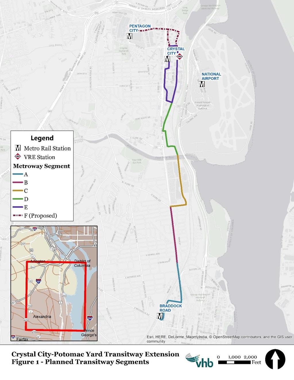
6 1 Introduction The Crystal City Potomac Yard Transitway (Transitway) is a 4.5-mile corridor dedicated to high-frequency, premium transit service from the Crystal City Metrorail Station in Arlington County to the Braddock Road Metrorail Station in the City of Alexandria. The corridor includes a right-of-way reserved for buses, as well as stations with raised platforms and custom shelters. The Transitway has regional significance because it offers the Washington metropolitan area s first bus-only lanes in recent decades 1, and it supports the region s first bus rapid transit (BRT) service, the Metroway. The Transitway has been constructed in multiple phases (segments). Figure 1 illustrates the six segments of the Transitway. To date, four segments of the Transitway have been completed: Segment A (from Braddock Metrorail Station to U.S. 1 and Potomac Avenue) Segment B (from U.S. 1 and Potomac Avenue to the U.S 1 and E. Glebe Road), Segment D (from the Alexandria-Arlington County border to Crystal Drive and 26 th Street S), and 1 The District of Columbia, Maryland, and Northern Virginia implemented bus-only lanes during the 1960s and 1970s. These lanes, however, were gradually eliminated, making the Transitway the region s first bus-only lanes in several decades. Source WMATA Memo on Bus Priority Lanes, Nov. 1976; MD-VA-Nov-1976.pdf 1 Introduction
7 Segment E (Crystal Drive and S. Clark Street/S. Bell Street from 26 th Street S to 15 th Street S). Segment C of the Transitway (U.S 1 and E. Glebe Road to the Alexandria-Arlington border) is scheduled to be completed in the spring of Segment F of the Transitway (from Crystal City Metrorail to the Pentagon City Metrorail) is currently being operated as an interim routing. The focus of this document is to assess past planning efforts associated with the Transitway, and recommend a preferred alignment to Arlington County for advancement into engineering, design, and ultimately construction. This document will cover the objectives of Segment F, as well as determine a final alignment, runningway option, and recommended station locations along the extension. 2 Introduction
8 3 Introduction
9 1.1 History of the Project The Transitway began as a joint project between Arlington County and the City of Alexandria in 1999 to support anticipated growth in the corridor. 2 Population and employment forecasts at the time projected significant population increases in Crystal City and Pentagon City by The increased population was expected to escalate local travel demand, and there were concerns about the transportation network s capacity to handle the additional volume and the impact of added traffic on transit performance. A 1999 Virginia Department of Transportation (VDOT) Crystal City/Potomac Yard Area Transportation Study found that road improvements alone would not provide enough capacity for the vehicular traffic associated with the proposed development. The study asserted that a transit-based solution was needed to reduce vehicle trips. 4 In March 2003, the Crystal City / Potomac Yard Transit Corridor Alternatives Analysis was completed by the Virginia Department of Rail and Public Transportation (DRPT). The study recommended BRT as the locally preferred alternative. In December 2005, the Crystal City/Potomac Yard Corridor Interim Transit Improvement Project Summary was released, providing a strategy for interim service in the corridor until higher-capacity service was available. The memorandum outlined exclusive right-ofway as a feature of the long-term transit solution. Following a lengthy federal review and public outreach process, construction of the Transitway began in The City of Alexandria completed segments A and B of the Transitway in August WMATA subsequently began operation of Metroway service from Braddock Road Metrorail Station to the Crystal City Metrorail Station, in anticipation of the construction of the other Transitway segments. 6 In spring 2016, Arlington County completed segments D and E of the Transitway, which included a new stop at 33rd Street S and Crystal Drive. During this time, WMATA also began operating an interim extension of Metroway service between the Crystal City Metrorail Station and the Pentagon City Metrorail Station. This interim extension began in anticipation of construction of Segment F, which would extend the Transitway to Pentagon City. The interim extension routing runs from Crystal City Metro along 18 th Street S and S Hayes Street to the Pentagon City Metro, then travels back east on 12 th Street S, S Eads Street, 15 th Street S, and S Clark 2 Summary of May City of Alexandria Planning Commission Action. 3 Arlington County s Round 7.1 Forecasts indicated a 60% population increase in Crystal City and 78% population increase in Pentagon City by It also projected an employment growth increase of 32% in Crystal City and 40% in Pentagon City for the same time period. These growth rates exceeded the overall County s employment and population growth rates of 33% and 22%, respectively. 4 Crystal City/Potomac Yard Transit Connection, Spring Metro News Release, July 1, Introduction

10 Street. Metroway operates in mixed traffic along this segment, because dedicated bus lanes are not present along those streets. 1.2 Current Transitway Infrastructure Arlington County s portion of the Transitway is from the Arlington-Alexandria border to Crystal City. The Arlington section of the Transitway begins on S. Glebe Road at Crystal Drive and proceeds northward alongside Jefferson Davis Highway/U.S. Route 1 and Crystal Drive until 26 th Street S. There, the Transitway terminates, and the bus operates in time-restricted travel lanes to 15 th Street S. At 15th Street, the bus travels west before looping south along S. Bell Street and S. Clark Street, to ultimately merge back onto Crystal Drive at 26th Street and return to Alexandria. Figure 2 illustrates the Transitway route. 5 Introduction


11 The segment of the Transitway alongside U.S. Route 1 and Crystal Drive, from S. Glebe Road to 26th Street, has exclusive bus lanes. These lanes are dedicated for buses only at all times and are separated from regular traffic by a raised curb. The lanes contain Bus Only pavement markings, and there are Do Not Enter signs displayed at the beginning and end points of this route segment to notify general traffic of the change in traffic pattern. The photo below displays the beginning of a Bus Only segment with Do Not Enter signage. Crystal City-Potomac Yard Transitway looking south down Crystal Drive at 29 th St S The remaining portions of the Transitway in Crystal City are rush hour bus lanes. Lanes on Crystal Drive between 26 th and 15 th Streets, and Clark Street between 15 th and 26 th Streets, are restricted to buses only on weekdays from 6:00 AM to 9:00 AM and 3:30 PM to 7:00 PM. Electronic signs positioned above the lanes alert drivers when the bus-only condition is in force. Stationary signs along streets also remind the public of buslane hours. During all other times, including all day on weekends, the lanes are open to general traffic. The image at right is an example of a stationary sign indicating the bus-only restrictions. Bus-Only Restriction Signage 6 Introduction
12 The Arlington portion of the Transitway also includes eight stations, at the following locations. The stations have custom bus shelters and 10-inch platforms to enable near-level boardings and alightings. Platforms are also 90-feet long to accommodate longer buses in the future. Seating, trash and recycling receptacles, and real-time transit information displays are also available. Stations have been designed to accommodate off-board fare collection in the future. Transitway stations are located at: S Glebe Road, between S Clark Street and Potomac Avenue 33 rd Street S and Crystal Drive 27 th Street S and Crystal Drive 23 rd Street S and Crystal Drive 18 th Street S and Crystal Drive Crystal City Metrorail Station 23 rd Street S and S Clark Street 26 th Street S and S Clark Street 7 Introduction

13 1.3 Metroway The Transitway currently supports the region s first BRT service, called Metroway. The service runs along the Transitway corridor, providing passengers with frequent, direct access between the Crystal City/Pentagon City and Potomac Yard areas. The current Metroway Route operates from the Braddock Road Metro Station to the Pentagon City Metro Station. Metroway buses stop at all of the Arlington Transitway stations described in Section 1.2. It also makes the following stops in Alexandria: Braddock Road Station Potomac Avenue Custis Avenue Swann Avenue East Glebe Road Reed Avenue The Metroway runs every six minutes between Crystal City and Potomac Yard, and every 12 minutes between Braddock Road and Pentagon City during weekday morning peak hours (5:30 AM to 8:00 AM). Buses run every 12 minutes during daytime off-peak hours and every 15 minutes during evening hours. On weekends, the route operates on 20 minute headways. The Metroway Route operates from 5:30 AM to 10:19 PM Monday to Thursday, from 5:30 AM to 12:20 AM on Friday, from 6:30 AM to 12:20 AM on Saturday and from 7:30 AM to 10:20 PM on Sunday. The Metroway route follows the Transitway infrastructure, with the exception the interim routing to Pentagon City. Connections can be made between the Metroway Route and Metrorail s Blue and Yellow Lines at the Braddock Road, Crystal City, and Pentagon City stations. Passengers can also connect to Metrobus routes from the Metroway bus Metroway. Metroway connects to Metrobus routes 10A, 13Y, 74, 84, and 9A at the Pentagon City Metrorail station, and Metrobus routes 92, 16H, and 10R at the Crystal City Metrorail station. 8 Introduction
14 The Metroway connects to ART routes at the Pentagon City and Crystal City Metrorail stations. Passengers can access ART 74 and 84 at the Pentagon City Metrorail station, and ART 43 and 92 at the Crystal City Metrorail station. Connections to DASH bus routes (operated by the City of Alexandria) can be made at the Braddock Road Metrorail station, and access to OmniRide service (operated by the Potomac and Rappahannock Transportation Commission) is also available at Crystal City. The Crystal City VRE Station at 1503 Crystal Drive is approximately 0.1 miles from the 18 th & Crystal Station, which is approximately 0.1 mile from the Crystal City Metrorail Station. Additionally, Metroway connects to the Mount Vernon Trail at the 18 th & Crystal Station, and the Four Mile Run Trail at the S Glebe Station. Capital Bikeshare stations can be found near multiple Metroway stations. 1.4 Other Multimodal Services Arlington County has invested heavily in other transportation options to address the diverse travel needs of the people who live, work, and visit Arlington. These options provide a network that covers both Pentagon City and Crystal City, and provide connections to the broader region. The following is a summary of the available options outside the Transitway and corresponding Metroway service. Transit The foundation of transit service in Pentagon City and Crystal City are the Blue and Yellow Metrorail lines. The Blue line runs from the Franconia-Springfield area in Northern Virginia to the Largo Town Center in Largo, Maryland. The Yellow line originates in the Huntington area of the City of Alexandria and continues through the District of Columbia to Fort Totten, located at the northern edge of DC. Much of the bus service in the area is provided through WMATA Metrobus routes. There are eighteen (18) total Metrobus routes that link Pentagon City and Crystal City to other destinations in Arlington County and across the region. There are six (6) ART bus routes that operate in the Pentagon City and Crystal City areas, providing local service within Arlington County. These routes provide connections between Pentagon City/Crystal City corridors and other urban villages in the County. In addition to Metrobus and ART, there are other transit agencies which provide connections to this area from outside Arlington County. These include: Fairfax Connector (Connector), Loudoun County Transit (LCT), Potomac Rappahannock Transportation Commission (PRTC) buses, DASH from the City of Alexandria, and other commuter buses. The Virginia Railway Express (VRE) has a station in Crystal City, bringing commuters into the area from both the I-66 and I-95 corridors. Once 9 Introduction

15 arriving in the area, many travelers use local transit routes to reach their final destination. Bike Facilities The Pentagon City and Crystal City areas have bike infrastructure that enable bicycle access to key community landmarks, such as the Metrorail stations, community centers, and schools. Although most streets around the Pentagon City Metrorail Station are multi-lane roads with relatively heavy automobile traffic, many of the main travelways have biking facilities. Portions of S Hayes Street, S Eads Street, and S Joyce Street adjacent to the Pentagon City Metrorail Station all have dedicated bike lanes. As bicyclists travel south of 15th Street S, the bicycling environment becomes more comfortable, with protected bike lanes separated from automobile traffic by parked vehicles. Bike Lane along S Hayes St separated by parking and bollards. Bikeshare/Carshare/Rideshare Capital Bikeshare and Zipcar stations are also widely available throughout this corridor. There are more than 10 Capital Bikeshare stations and more than 10 Zipcar locations within the Pentagon City-Crystal City area. Car2Go is another carsharing service available in the area that allows users to reserve and drive cars without the need to return the car to the same location. Ridesharing services such as Uber and Lyft provide another option for traveling without owning a car. All these services can 10 Introduction
16 provide vital links between the beginning and end of a transit trip. While Arlington County benefits from a robust public transportation system, the first-mile/last-mile problem still exists, and these type of sharing services can improve accessibility without motor vehicle ownership. 11 Introduction
17 2 Transitway Extension Objectives An extension of the Transitway to Pentagon City is planned to support anticipated growth in this area of the County. The extension also increases the transit capacity in the area and offers another multimodal option for travelers. 2.1 Support Anticipated Growth The Transitway extension will address growing travel demand in Crystal City and Pentagon City, two significant business districts in Arlington. Both neighborhoods are projected to experience significant population and employment growth. By 2025, the population of Pentagon City is forecasted to increase by 41% and employment is also expected to grow by 41%. In Crystal City, the population is forecasted to grow by 25% while employment is forecasted to grow by 9%. 7 Figures 3 and 4 illustrate the areas of population and employment change. The additional growth in the Pentagon City and Crystal City neighborhoods will required increased transit capacity, which the Transitway extension will provide. 7 Percent change in population and employment calculated from 2025 population and growth values forecast as part of the MWCOG Cooperative Forecast version Transitway Extension Objectives

18 13 Transitway Extension Objectives
19 2.2 Increased Transit Capacity The through-capacity of transit in the Crystal City and Pentagon City corridors will be improved if rapid transit features are extended to Pentagon City. By enabling Metroway buses to complete their route faster, the Metroway system is able to complete more trips and serve more passengers in the corridor. This additional capacity can provide relief to both local bus routes and the Metrorail system. This increased capacity will relieve some of the ridership burden on the Yellow and Blue Metrorail lines. During 2015, ridership at the Crystal City, Pentagon City, and Pentagon Metrorail stations were the highest along the Blue and Yellow line segments in Virginia. 8 Providing an additional transportation alternative could help alleviate the congestion along this portion of the Metrorail system. The increased transit capacity will help to address reduced frequency on the Blue Line. With the launch of the Silver Line in 2014, WMATA reduced service frequency on the Blue Line to create capacity for the operation of Silver Line trains. An expansion of Metroway service into the Pentagon City corridor will help to address demand for frequent, reliable transit along portions of the Blue Line corridor. 2.3 Enhanced County and Regional Connections The extension of the Transitway to Pentagon City will provide an additional connection between Pentagon City and Crystal City (two key activity centers in Arlington), with Potomac Yard and Braddock Road (two other activity centers in Alexandria). The extension will also provide new, direct access between developing residential areas and anticipated job opportunities and retail development. The Transitway will also serve those connecting to Pentagon City and Crystal City from other parts of the County and beyond. The County plans to improve connections between Columbia Pike and the Pentagon City/Crystal City corridor. There is existing bus service that connects Pentagon City and Crystal City to the Rosslyn-Ballston corridor. Additionally, the VRE connects commuters from as far as Manassas and Fredericksburg to Crystal City. The Transitway would provide these transit riders with an additional option for connecting to Pentagon City, Crystal City, or other points of interest in Arlington County and the City of Alexandria. 8 Metrorail Average Weekday Passenger Boardings Transitway Extension Objectives

20 2.4 Support Multimodal Goals Some goals of the Arlington County Master Transportation Plan are to Provide high-quality transportation services for all users and modes ; move more people without increasing traffic congestion; and support Complete Streets. The County s goals, and policy, require multimodal solutions. The County has already invested in multimodal projects like local and regional bus service, bike facilities, bikesharing, and carsharing. Extension of the Transitway and growth of services such as Metroway support these goals and policies. 15 Transitway Extension Objectives
21 3 Transitway Extension Assessment Extending the Transitway requires identifying the appropriate alignment (route); determining the ideal runningway (guidetype); and identifying the locations for new stations. The following sections describe the various considerations associated with each component of the extension, and weighs the pros and cons of each alternative. 3.1 Extension Alignment Arlington County seeks to determine the preferred route alignment for the next segment of the Transitway (Segment F), which stretches from the Crystal City Metrorail Station to the Pentagon City Metrorail Station. Previous planning efforts identified Crystal Drive, 12 th Street S, and S Clark Street as the ideal routing 9. This routing was adopted by the County Board in September of 2010 as part of the Crystal City Sector Plan. This document reviews the 12 th Street S connection, as well as two other alternatives (15 th Street S and 18 th Street S), to determine if the alignment should change before being finalized. 9 Crystal City Multimodal Transportation Study: A supporting document of the Crystal City Sector Plan, Kimley Horn and Associates, Inc., February Transitway Extension Assessment

22 12 th Street S (Option A) Under this option, the Transitway would run north on Crystal Drive, east and west on 12 th Street S, and south on S Clark Street. Upon reaching S Hayes Street, the Transitway would terminate and the Metroway would either turn south and U-turn to return to the Transitway; or a second option would be for the Metroway to turn north and travel in mixed traffic up to Army Navy Drive where it would turn around in a future transit center at Army Navy Drive and Joyce Street. Figure 7 shows the proposed alignment using 12 th Street S. 17 Transitway Extension Assessment

23 Right-of-way 12 th Street S has a right-of-way approximately 72 feet wide. The actual curb-to-curb distance varies depending on the block, with some blocks containing on-street parking. The existing curb-to-curb distance is wide enough to accommodate the transitway lanes, although approximately 50 parking spaces along Crystal Drive would need to be eliminated to create the northbound bus lane. The parking along this segment of Crystal Drive was planned to be temporary while planning and design of the Transitway took place. The conversion of the existing parking lane to a bus lane will likely impact the existing slug-line location where Crystal Drive transitions into 12 th Street S. The County should consider identifying a suitable replacement location nearby. One option may be along Long Bridge Drive. Traffic Impacts The relatively low traffic volume, and the fact that there is only a single major intersection at 12 th and Hayes, would provide a more reliable trip for transit vehicles. Future Growth and Development The future population and employment growth around stations along the potential alignment was determined using the forecasted population and employment growth for 2025 from the MWCOG Cooperative Forecast version 8.4. The 2025 population along 12 th Street S is forecast to be 8,600 with 26,500 jobs. Several development projects are planned for this block, which are expected to increase the population and employment density along the street. Among these 18 Transitway Extension Assessment
24 projects is Pen Place, a mixed-use project that will include almost 2 million square feet of office space, ground floor retail, a hotel, and up to 300 residential units. Just south of Pen Place will be Metropolitan Park, a mixed-use project that spans 16 acres. The fourth and fifth phases of this project will face 12 th Street and include 699 residential units as well as 40,797 square feet of retail space. Additionally, Pentagon Centre is planned for redevelopment that includes the addition of over 700 dwelling units and 29,000 square feet of retail. These anticipated projects are expected to increase local travel demand. Routing the Transitway through this block would support the greater travel demand associated with development, and take advantage of an area with a large concentration of residences and jobs. Other Considerations Some Crystal City residents expressed concern about the safety of buses turning from Crystal Drive onto 12 th Street S. Their concerns relate to the radius of the curve, concerns that the buses would be challenged to make the turn without departing the lane, concerns about pedestrian safety, the loss of on street parking, and the overall increase in activity and noise. A modified version of this alignment option was proposed. Under the modified alignment, buses would use S. Clark Street instead of Crystal Drive for northbound travel to 12 th Street S. It is believed that this re-alignment would reduce impacts along Crystal Drive, preserve on-street parking, and avoid displacement of existing slug line activity on the block. As part of this analysis, computer simulations were run to assess whether a typical 40 foot bus could navigate the curve at Crystal Drive and 12 th Street S. In addition, the right turn from 15 th Street S to S Clark Street was assessed to determine how the bus would navigate this turn. The simulations show a typical 40-foot bus can navigate the curve from Crystal Drive onto 12 th Street S in the northbound direction. On the contrary, the bus was not able to navigate the right turn from 15 th Street S onto S Clark Street without departing the lane or requiring a design modification to the corner radius of the curb. An assessment of the same curve on Crystal Drive using a 60 foot, articulated bus, showed that some minor restriping would improve operations without impacts to the existing curb line. A more detailed description of the analysis is included in Appendix A. An evaluation of S. Clark Street shows several driveways with curb cuts along the street, especially between 12 th Street S and 15 th Street S. The multiple driveways leave limited space for the placement of a transit station with a 90-foot platform. Adding a bus lane in these blocks of S Clark Street would also require the elimination of a proposed bike lane, creating a hole in the County s bicycle network. For these reasons, it is recommended that the 12 th Street S alignment utilize Crystal Drive, instead of S. Clark Drive. 19 Transitway Extension Assessment
25 Table 1: Summary of Pros and Cons for 12 th Street S Transitway Alignment Length (mi) Pros Cons 1.70 right-of-way is wide enough to accommodate bus lane lowest traffic volume of all options only major intersection at 12 Th & Hayes future development is focused along 12 th St.; travel demand is expected to increase Loss of 50 parking spaces along northbound Crystal Dr. Crystal Dr. is a slug line pick-up/drop-off point; slug line participates would need to find alternative site 15 th Street S (Option B) A second alternative alignment considered utilizing 15 th Street S for the Transitway. The Transitway would run west on 15 th Street S, go north on S Hayes Street to the Pentagon City Metro, turn around, and follow S Hayes Street back to 15 th Street S to S Clark Street. Figure 8 shows the proposed alignment using 15 th Street S. Right-of-way 15 th Street S currently has four ten-foot wide travel lanes, with on-street parking, and bike lanes along both sides of the roadway. To accommodate a bus-only lane, one of the travel lanes would need to be repurposed, or transit vehicles would need to operate in mixed traffic. There are limited opportunities to widen 15 th Street S considering the existing development layout. Traffic Impacts 15 th Street S carries the highest traffic volume of the three options considered (average annual daily traffic at 14,000 vehicles). The high traffic volumes and inability to widen the street reinforce the assumption that buses would be operating in mixed traffic. A mixed traffic treatment would result in greater impacts to bus operations and decrease reliability of the Metroway service. Future Growth and Development The future population and employment along the 15 th Street S corridor is forecast to be 10,300 people and 14,800 jobs in This is slightly more people than are forecast along 12 th Street S, but significantly fewer jobs. The land adjacent to the proposed Transitway is mostly developed, but two new developments along the northern edge of 15 th Street S will be completed in the near future Metropolitan Park Phase 6 and Pentagon Centre. These projects will increase employment density and local travel demand in the area. This increased demand will generate a need for additional transportation capacity. 20 Transitway Extension Assessment

26 Other Considerations Metrobus routes 10A and 13Y already serve 15th Street S. Extending the Transitway along 15 th Street S would result in Metroway service competing with these other routes in this constrained environment. Table 2: Summary of Pros and Cons for 15 th Street S Transitway Alignment Length (mi) Pros Cons 1.40 Two development projects on block are expected to increase travel demand on this street Highest traffic volume of all three options 14,000 ADT Constrained roadway. Lane repurposing or mixed traffic operations would be required Competition with other bus routes Stations sited along a corridor with few redevelopment opportunities 21 Transitway Extension Assessment

27 18 th Street S (Option C) Under this alignment, the Transitway would travel northbound along Crystal Drive, before turning west onto 18 th Street S instead of continuing on to 15 th Street S. The route would continue onto S Hayes Street, stopping at the Pentagon City Metro, and then returning to S. Clark Street via S Hayes Street and 18 th Street S. Figure 9 shows the proposed alignment. Right-of-way Much like 15 th Street, 18 th Street S is constrained by existing infrastructure. Implementing an extension of the transitway would involve repurposing a lane or instituting mixed traffic operations. Converting a parking lane to a dedicated bus lane would result in the loss of roughly 100 parking spaces and elimination of protected bike lanes. The protected bike lanes are a significant amenity, and high profile element of the County s bicycle infrastructure. Removing this buffer would greatly impact the cycling experience. The siting of stations may also be challenging because of the lack of redevelopment along the corridor. Future Growth and Development Future population and job growth along the 18 th Street S alignment is less than the other two corridors. The 2025 population is forecast to be 6,800, 2025 employment is forecast to be 13, Transitway Extension Assessment
28 Many parcels along 18 th Street S are already built out, with little redevelopment proposed along the corridor. Local travel demand for this corridor would likely remain unchanged into the future. Table 3: Summary of Pros and Cons for 18 th Street S Transitway Alignment Length (mi) Pros Cons 1.80 Constrained roadway. Lane repurposing or mixed traffic operations would be required Competition with other bus routes Stations sited along a constrained corridor with few redevelopment opportunities Summary of Alignment Options Based upon the preceding analysis, 12 th Street S offers the greatest capacity for construction of bus-only lanes with fewer impacts to the comprehensive transportation network. 15 th Street S functions primarily as a vehicular corridor with some capacity to support cycling. 18 th Street S provides protected bike lanes, providing cyclists a preferred routes through Pentagon City and Crystal City. Because 12 th Street S is not currently fully constructed, it has not developed as a key corridor for any particular mode. While there is a desire to provide streets that accommodate all users, the highly developed nature of this area presents a challenge to design streets that serve all users equally. This presents an opportunity to make 12 th Street S focused on transit users. This corridor is closest to the highest concentration of future development and growth, allowing a high-capacity transit service to take full advantage of this growth. For these reasons, it is recommended that Segment F be implemented along 12 th Street S. 23 Transitway Extension Assessment

29 3.2 Transitway Location An evaluation of different location options for the transitway was conducted as part of this analysis. The assessment was focused on identifying a preferred location for the lanes within the existing and proposed street cross-section. Assuming that 12 th Street S is used for the Transitway extension, there are several options for the placement of bus lanes along the route alignment. Each option would have a different impact on the operation of bus service and on the street environment. The following section identifies the different options available for Segment F and compares their effects. Curbside Bus Lanes Under this option, the transitway would be positioned in the rightmost travel lane on 12 th Street S, immediately adjacent to the curb. This configuration is beneficial because it provides pedestrians with direct access to station platforms located adjacent to the sidewalk. It also eliminates conflicts with left-turning vehicles since the bus lane is positioned to the right of vehicular traffic. Placing the transitway next to the curb does not eliminate all potential vehicular conflicts, however. Right turning vehicles would need to enter the bus lane to complete turns. Another consideration is the size of transitway station platforms will be larger than a traditional bus stop. This size difference can have impacts on the pedestrian travel zone in locations where there is limited right-of-way. It will also be 24 Transitway Extension Assessment
30 difficult to completely separate the station activities from the pedestrian activities, resulting in potential conflicts around the station platform between bus passengers and pedestrians. The most significant impact of a curbside transitway is to on-street parking. Since the transitway is positioned where on-street parking is typically permitted, on-street parking spaces would need to be relocated or eliminated to create space for the transitway. One option would be to place parking between the curbside bus lane and the travel lane for vehicles. This type of floating parking lane is often used as a way to create a buffered bike lane. While buffering a bike lane with on street parking has tremendous benefits for protecting cyclists, using a similar street design to buffer the transitway presents numerous challenges. The first issue is the limited right-of-way available. Placing a parking lane between two lanes of moving traffic, whether bicycle or bus, would require some additional buffer. The space to accommodate this along 12 th Street is not available. Without the buffer the margin for error in parking between the lines would be small, likely resulting in instances where a parked vehicle blocked the transitway. Therefore, this option was not considered further. The loss of on-street parking could be avoided through an offset configuration known as an interior transitway. Under this design, on-street parking spaces are provided through a cutout in the sidewalk, to the right of the bus lane. Interior Bus Lanes An interior bus lane would be offset from the curb to allow on-street parking to the right of the bus lane. This configuration offers many of the same benefits as a curbside transitway easy pedestrian access to stations and elimination of conflicts with left-turning vehicles. This configuration also preserves on-street parking. The offset configuration allows for stations to be accommodated through bulb-outs from the curb, reducing potential impacts to sidewalks, and providing a shorter crossing distance for pedestrians at intersections. An interior runningway, however, requires a wider cross-section to accommodate parking, resulting in a larger impact to existing right-of-way. There is still the potential for conflicts with right-turning vehicles, since the bus lane would still occupy the right-most lane. And while this configuration preserves on-street parking spaces, drivers would have to cross the bus lane to access the spots, creating a potential conflict area. One benefit of operating a bus service in the transitway versus a streetcar, is that the bus can deviate from the transitway to avoid improperly parked vehicles or other obstacles that would render a streetcar service inoperable. Median Bus Lanes Under this configuration, the transitway would occupy the two center lanes of the street. The configuration provides buses with the greatest operational benefit 25 Transitway Extension Assessment
31 because buses can avoid possible obstructions, like vehicles illegally parked in the bus lane. A median transitway also allows buses to avoid conflicts with right turning vehicles. A median transitway would increase the visibility of transit service in the corridor, encourage ridership, and reinforce the permanence of the transitway to developers. The median transitway option would require pedestrians to cross the travel lane to access median station platforms. While this option removes conflicts with vehicles making right turns, it does create a conflict with left turning vehicles. This conflict can only be solved by adding separate signal phases for left turning vehicles and the through movement of buses. This may require additional right-of-way for separate left turn lanes so vehicles can turn safely and not impede through traffic. The rightof-way would also need to be wide enough to accommodate transit stations in the middle of the street; and ideally, some right-of-way would be devoted to creating a physical separation between the transitway and other travel lanes. Currently, right-of-way along 12 th Street S has been set aside as part of the Pen Place and Metropolitan Park developments for a future transitway with median station platforms between S Fern Street and S Eads Street. However, in the blocks from S Hayes Street to S Fern Street, and from S Eads Street to Crystal Drive, additional right-of-way would be needed to accommodate median station platforms. The proposed cross-section also presents challenges for implementing a physical barrier between the transitway and vehicular traffic. Siting of the transit stations will need to consider the constraints, and may require a transitway that transitions from one configuration to another within the street. Table 4 summarizes the advantages and disadvantages of the three runningway options. 26 Transitway Extension Assessment
32 Table 4: Summary of Transitway Location Options Option Pros Cons Curbside Interior Provides easy pedestrian access to platforms Eliminates conflicts with left turning vehicles Provides easy pedestrian access to platforms Transit platforms can be accommodated through sidewalk bulb-outs, reducing impact to pedestrian travelway Eliminates conflicts with left turning vehicles Allows for some on-street parking Station platforms may impact pedestrian areas Potential for conflicts with right turning vehicles Parking lane would need to be relocated or eliminated Potential for conflicts with right turning vehicles and parking vehicles Requires a wider right-of-way Median Offers the greatest operational benefit to transit Eliminates conflicts with right turning and parking vehicles Enhances visibility of the infrastructure and transit infrastructure Left-turn lanes require additional right-of-way and signal phasing Additional right-of-way may be needed to accommodate transit stations Proposed cross-section presents challenges to creating physical separation between Transitway and travelway Requires pedestrians to cross travel lane to access transit stations Summary of Transitway Location A curbside transitway was found to be the easiest to adapt to the existing right-ofway in the 12 th Street S corridor. The current transitway along Crystal Drive operates along the curb, eliminating the need for an additional signal phase and transition from the curb lane to the median. However, the curbside location offers less visibility than a median transitway. There are also concerns that a curbside transitway between S Eads Street and S Fern Street would result in conflicts with vehicles attempting to park in the transitway, because a grocery store is approved there as part of the new development. Discussions with Arlington County reinforced the need for the transitway continuing as a prominent feature of the street, elevating its visibility, and positioning it for future success. For these reasons, it was recommended that the transitway should operate in the median from S Clark Street to S Hayes Street. The transitway will continue to operate along the curb of Crystal Drive from 15 th Street S to 12 th Street 27 Transitway Extension Assessment

33 S, transitioning to the median at S Clark Street. In the southbound direction the transitway will depart the median guideway approaching Army-Navy Drive. This will give the bus adequate distance to transition to the curb and turn right onto S Clark Street. Additionally, it was determined that the proposed terminus south of S Hayes Street and 12 th Street S was not desirable for transit operations because of the U-turn required. A planned transit center located in the parking lot south of I-395 and between S Hayes Street and S Joyce Street would provide a better terminus because of a connection to the Pentagon via a pedestrian tunnel under I-395. The construction timeline for this transit center is not presently known, so the Transitway extension may require the S Hayes St U-turn as an interim operating route. 3.3 Transitway Extension Stations The following section describes the assessment for station locations along the transitway extension. It describes the criteria used for location selection, how station platforms will be configured, and the operational benefits and challenges of each station. 28 Transitway Extension Assessment
34 Station Spacing The average spacing of transit stations along the Metroway varies between 1,000 and 4,000 feet. Most stations are spaced every 1,000 feet in densely developed areas, and every 2,500 feet in areas of less-dense development. The proposed extension corridor along 12 th Street S (from S Hayes Street to Crystal Drive) is 3,000 feet. Given the density of the area, this length will require two to three stations. The Pentagon City Metrorail station near 12 th Street S and S Hayes Street is a key destination that warrants a transit station. Assuming a transit station is placed at the Pentagon City Metrorail station, Table 5 outlines the distance between all the intersections along the recommended route. Based on this information, S Elm Street, and Long Bridge Drive provide reasonable station spacing. Table 5: Street Spacing along 12 th Street S and Crystal Drive Street Pentagon City Station (Proposed Terminal Station) S Fern Street S Elm Street S Eads Street Army Navy Drive Long Bridge Drive Crystal Drive (Existing Station) Distance between Streets (From Center of Intersection) 0 Feet 400 Feet 310 Feet 420 Feet 670 Feet 180 Feet 500 Feet Land Use and Activity The location of any station should consider connections to major generators of ridership, access by different modes of transportation, opportunities to facilitate transfers, as well as street-level activity. The availability to accommodate station platforms in either a median- or curb-running busway configuration should also be considered. A block that is suitable for a station offers buildings that front the street, as well as easy pedestrian access. These elements help to create demand for transit. Most blocks along the 12 th Street S corridor meet these criteria. 29 Transitway Extension Assessment
35 Table 6: Existing and Future Land Uses along 12 th Street S and Crystal Drive Stop Location Land Use Suitability S Hayes Street to S Fern Street South Side Good Approved redevelopment of existing commercial uses to provide 714 residential DU, 29,094 SF of new retail, and the existing 325,300 SF of existing retail. New 25-story would front to both 12 th and Hayes with ground-level retail, parking, and 440 residential units. Residential lobby would front to 12 th. Parking would remain accessible from 12 th until future development shifts to extended Grant Street. North Side Good Active street fronting land uses on block, but set back from street. Transportation Security Administration is here too. S Fern Street to Elm Street South Side Good Active street fronting land use being constructed. Approved two residential buildings with 699 DU and 40,797 SF of retail with grocery. North Side Good Active street fronting land use approved. Approved development which could provide up to 1.8 million SF of Office, 300 hotel units, 50,000 SF of retail, and an option for 300 residential DU. Elm Street to S Eads Street South Side Good Active street fronting land use being constructed. Approved two residential buildings with 699 DU and 40,797 SF of retail with grocery. North Side Good Active street fronting land use approved. Approved development which could provide up to 1.8 million SF of Office, 300 hotel units, 50,000 SF of retail, and an option for 300 residential DU. S Eads Street to Army Navy Drive South Side Poor Residential buildings do not front the street, and the rest of the block includes a parking structure. North Side Good Half of block includes surface and structured parking, and a 22-story residential tower (Lenox Club) with ground-level retail. The retail entrances front to 12 th Street, while the apartment building entrances face the parking lot. Army Navy Drive to Long Bridge Drive South Side Poor U.S. 1 overpass North Side Poor U.S. 1 overpass Long Bridge Drive to Crystal Drive South Side Good Some active street fronting land uses on block. Primarily office buildings with some ground-level retail. North Side Good Some active street fronting land uses on block. These include primarily offices with access to Long Bridge Park and Boeing s office from 12 th Street. There is also a known slug-line pick-up location here. The location is near the bend from Crystal Drive to 12 th Street with two-lines forming. 30 Transitway Extension Assessment
36 Station Selection Based upon spacing and land use, S Elm Street and S Clark Street appear to be strong candidates for stations, assuming a station at the Pentagon City Metrorail station. An additional station is proposed along Crystal Drive at 15 th Street S to provide access for users located along Crystal Drive between the existing station at 18 th Street S and the proposed station at S Clark Street. Figure 12 shows the approximate location and platform type of the proposed stations. Station Concepts The following section considers options for station siting and type, and the potential impacts to right-of-way and transit operations of those choices. Pentagon City Metro The Pentagon City Metrorail station is a key destination that will support a Metroway station. 12 th Street S and S Hayes Street form a three-way intersection, which poses a challenge for the placement of transit platforms to support eastbound and westbound bus service. While it is desirable to place median station platforms on the far side of the intersection, this is not possible at this location. Additional right-ofway will be required to place the platforms on the same side of the intersection. In addition to an option placing both platforms on the same leg of the intersection, 31 Transitway Extension Assessment
37 other alternatives were explored to reduce the right-of-way impacts along 12 th Street S. Drawings of the alternatives can be found in Appendix B. Option 1: Side-by-side transit platforms along 12 th Street S. Under this option, the median platforms for eastbound and westbound service would be adjacent to each other along 12 th Street S. This arrangement allows for all Metroway service (and future ART service) to be accessed at a single point, providing improved wayfinding and transfers. The configuration requires a significant amount of additional right-of-way, and further widening of 12 th Street S to fit the platforms. Option 2: A median platform along 12 th Street S for eastbound service and a curbside platform located in the northeast corner of S Hayes Street and 12 th Street S for westbound stops. Compared to Option 1, this concept requires less right-of-way along 12 th Street S. Reconstruction of intersections signals, curb ramps, pedestrian crossings, and other elements would likely be needed to accommodate the curbside platform. This platform configuration will require additional wayfinding signage to assist riders in locating the correct platform. This platform configuration also facilitates the connection of the Metroway to the future transit center at Joyce Street. This configuration reduces operational challenges by removing the need for the Metroway and future Metrobus 16M to make U-turns or other circuitous movements to access station platforms. Option 3: A single curbside platform at the southwest corner of S Hayes Street and 12 th Street S for both eastbound and westbound service. This option allows for the smallest impact to the right-of-way along 12 th Street S, and is adjacent to one of the Metrorail station entrances. After serving the platform, buses would need to perform a U-turn along S Hayes Street to return to 12 th Street S. This station location would also impact the proposed Metrobus 16M, which connects this area with Columbia Pike. When returning to Columbia Pike from Crystal City the 16M bus would have to travel southbound on Hayes to access the transit station, then make a U- turn to return to Columbia Pike. This longer routing would likely frustrate riders. Additionally, the site is currently used by commercial tour buses to load and unload passengers visiting Pentagon City Mall. The County would need to identify a new site for tour buses if the site is selected to build the transit platform, and there is limited curb space available. Option 4: This is a modification to Option 3 to improve the operations for future Columbia Pike service. A median platform would be constructed along 12 th Street S for westbound service and a curbside platform along S Hayes Street for eastbound service. This concept offers many of the same benefits and challenges as Option 3, 32 Transitway Extension Assessment
38 with the added operational advantage that the Metrobus 16M route would be able to use the median platform when traveling westbound and avoid making a U-turn on S Hayes Street. There are greater wayfinding and pedestrian safety challenges within this option because the platforms would be located across a wide and active intersection. Based on the analysis of the concepts and discussions with Arlington County about the benefits and challenges offered by each configuration, Option 2 has been tentatively identified as the preferred concept for the transit station at 12 th Street S and S Hayes Street. This option results in minimal additional impacts to the right-ofway along 12 th Street S, provides good access to the Pentagon City Metro station, and results in the fewest impacts to transit operations for either the Metroway or 16M. 12 th Street S and S Elm Street Two median platforms are proposed for 12 th Street S near S Elm Street. The platforms will be offset, with the westbound platform located on the west side of the intersection and the eastbound platform positioned on the east side of the intersection. This allows buses to clear the intersection before stopping to load and unload passengers. 12 th Street S and S Clark Street/Long Bridge Drive Based on the proposed route alignment for the Transitway, the concept for this station includes two curbside platforms on opposite corners of the intersection. The northbound station will be located on the nearside of 12 th Street S and Long Bridge Drive. The bus will stop along the curb before entering the intersection and transitioning to the median runningway. The southbound platform will be located in the southwest corner of the intersection. The bus will stop after turning right from 12 th Street S. The impact of this configuration is similar to that of Option 2 for the Pentagon City Metrorail platform. Less right-of-way is required for this design, but the distance between platforms and their unconventional positioning will require additional wayfinding signage to aid riders in locating the correct platform. 15 th Street S and Crystal Drive To maintain reasonable spacing between stations, a fourth transit station is proposed for 15 th Street S and Crystal Drive. Since only northbound service is provided along this segment, the station will be comprised of a single curbside platform along Crystal Drive. The platform should be located on the far side of the intersection to take advantage of future transit signal priority implementation. 33 Transitway Extension Assessment
39 Station Layout The following diagrams show the proposed station layout concepts. These layouts are similar in design to the existing Metroway stations, providing consistency across the Transitway. Stations will include a 90 foot long platform that is at least 12 feet deep. The curb height will be 10 inches, requiring a transition from the surrounding sidewalk, and the appropriate tactile warning devices along the curb edge. Stations will be designed with one or two shelter canopies depending on available space and activity levels. Trash and recycling receptacles will be included, as well as space for off board fare collection devices. As the project advances into preliminary engineering and design, details related to utility relocation, specific placement of station elements, and any modifications to the overall design will be made on a location-specific basis. Figure 13: Median Station Platform Concept Figure 14: Curbside Station Platform Concept 3.4 Transitway Extension Costs Arlington County had developed a preliminary cost estimate for the Crystal City- Potomac Yard Transitway extension based on the transitway alignment and design, station number and location, and other initial planning concepts. The initial estimate for the entire cost of the transitway extension, including an extension to Joyce was approximately $23.5M. This early 2015 cost estimate has been updated to reflect the recommendations and changes identified as part of this planning study. This estimate carries forward the unit costs identified as part of the earlier County cost estimate. Major changes from the initial estimate include an additional station at Crystal Drive and 15 th Street S, and the preferred concept for the transit station locations at 12 th Street S and S Hayes Street were included in these changes. The estimated cost to design and construct the extension of the Transitway from 15 th Street S to S Hayes Street is approximately $18.9M. Extending the Transitway to the future transit center at Army-Navy Drive and S Joyce Street is $6.9M. The total cost 34 Transitway Extension Assessment
40 to design and construct the Crystal City-Potomac Yard Transitway extension is approximately $25.8M in 2016 dollars. More detailed information can be found in Appendix C. This estimate includes a number of assumptions as well as contingency factors to account for the conceptual nature of the planning. As preliminary engineering and design advance, this cost can be refined based on specific details identified through survey and design. 3.5 Transitway Extension Ridership Forecast Ridership projections were made by determining what portion of the population around existing stations use the Metroway service, and applying that percentage to population forecasts from the Metropolitan Washington Council of Governments Cooperative Regional Forecast 8.4. Proposed station locations were buffered by ¼ mile (a reasonable transit walking distance), and the proportion of the demographic zone (TAZ) that fell within that ¼ mile area was used to determine the existing and projected population and employment numbers for that transit stop. Population served as the proxy for boarding data, and employment represented alighting data. These numbers are displayed below. The majority of this demand for transit is expected to occur at the 12 th and Elm Street station. Table 7: Crystal City-Potomac Yard Transitway Extension Ridership (2025) Proposed Stop Location 12 th Street S & S Clark Street 12 th Street S & Elm Street 12 th Street S & S Hayes Street Crystal Drive & 15 th Street S Projected 2015 Boardings Projected 2025 Boardings Projected 2015 Alightings Projected 2025 Alightings Army Navy Drive Summary Arlington County forecasts significant population and employment growth over the next ten years in Pentagon City and Crystal City. This growth requires the County to continue to advance their goals for increasing multimodal options. Projects like the extension of the Crystal City-Potomac Yard Transitway are part of the County s plan to respond to increasing demand on the existing transportation system by expanding capacity and providing improve services. 35 Transitway Extension Assessment
41 After reviewing three corridors connecting Crystal City and Pentagon City, it is recommended that the transitway extension be routed along 12 th Street S. This corridor is located between many planned high densities, mixed use developments. The corridor provides an opportunity to replicate the median bus lane transitway design found near Potomac Yard. This corridor allows for high-profile service near planned population and employment centers, without significant impacts to right of way. Curb running bus lanes are recommended to be utilized along Crystal Drive, S Hayes Street, and Army-Navy Drive. Stations will be located approximately every 1,000 feet, starting at the Pentagon City Metro. Stations will also be located at 12 th Street S and S Elm Street, Long Bridge Drive and S Clark Street, Crystal Drive and 15 th Street S, and Army-Navy Drive and S Joyce Street. Stations will be similar in design to those currently constructed. Once complete, the Crystal City-Potomac Yard extension will provide travelers a reliable, high-frequency, high-profile alternative to Metrorail for trips between the City of Alexandria and the Pentagon. The extension will also support the continued development at Potomac Yard, in Crystal City, and Pentagon City. 36 Transitway Extension Assessment
42 Appendix A: AutoTURN Analysis Appendices
43 15th Street S & S Clark/S Bell Street Bus AutoTURN Analysis Currently 15th Street S intersects the road network of S Clark/S Bell Street at three discontinuous locations: a grade-separated crossing at S Clark Street, an at-grade T- intersection at S Bell Street, and an at-grade T-intersection at 14th Road S, east of S Bell Street. Proposed plans will remove the grade-separated crossing of S Clark Street over 15th Street S. Additionally, the two at-grade intersections will be consolidated into a single intersection by realigning S Clark Street to meet S Bell Street at 15th Street S. A proposed routing option of buses through Crystal City includes buses traveling westbound on 15th Street S and turning right onto northbound realigned S Clark Street. This routing was analyzed to verify if there will be any challenges due to the geometry of the intersection. The geometry of the proposed realignment of S Clark Street north of 15th Street S has three vehicular travel lanes (two southbound lanes and a single northbound lane) as well as a curb-separated northbound bicycle lane. The analysis was completed using two different design vehicles: a standard bus with a 40-foot wheelbase and an articulated bus with a 60-foot wheelbase. Three different scenarios were investigated for each design vehicle: Scenario 1 - Buses on westbound 15th Street S turn from the right lane to avoid hitting the curb radius, sidewalk, and the curb buffer for the bicycle lane, in the northeast quadrant of the intersection. However, the buses must cross the double-yellow center line and enter the southbound left lane on S Clark Street. Scenario 2 - Buses on westbound 15th Street S swing out into the left lane to avoid entering southbound travel lanes on S Clark Street. However, the buses would not be able to avoid hitting the curb buffer for the bicycle lane. Scenario 3 - Buses on westbound 15th Street S turn from the right lane and crosses curb and sidewalk along the northeast corner of the intersection to avoid entering southbound lanes on S Clark Street. Similar to Scenario 2, the buses would not be able to avoid hitting the curb buffer for the bicycle lane. A detailed description of the results for each of these three scenarios is included below. The results of this analysis indicate that none of the three scenarios are ideal. All three scenarios would require changing the geometry of the intersection to the bus routing option along S Clark Street navigable. If the bus had to be routed along S Clark Street, the best option for redesign of the intersection geometry would be to modify the curbed buffer between the northbound travel lane and the northbound bicycle lane. As an alternative to the routing option of buses on westbound 15th Street S to northbound realigned S Clark Street, the routing of buses northbound on Crystal Drive to westbound 12th Street S was also analyzed. Minor restriping to adjust lane widths along the curve between Crystal Drive and 12th Street S would be required for this alternative. Based on the AutoTURN analysis, this route is recommended as the preferred alternative for routing of buses through Crystal City. Appendices
44 Scenario 1 Under this scenario although the buses would avoid running over the curb and sidewalk in the northeast quadrant of the intersection, the buses would need to enter the left-lane of southbound S Clark Street. The analyses for the paths of the 40-foot standard bus and 60-foot articulated bus for this scenario are shown in Figure 1 and Figure 2, respectively. In order for the 40-foot standard bus to avoid queued vehicles in the left-lane on S Clark Street, the proposed stop bar would need to be moved approximately 30 feet to the north. Similarly, in order for the 60-foot articulated bus to avoid vehicles on S Clark Street, the stop bar would need to be moved approximately 60 feet north of its currently proposed location. As seen in Figure 2, the maneuver for the 60-foot bus would be difficult since the bus driver would be required to make a sharp turning movement to the left once on S Clark Street. If a smoother path was desired for the 60-foot articulated bus, the stop bar on the southbound approach would need to be moved even further to the north. There are several disadvantages of moving the stop bar 60 feet to the north such as modification to the existing traffic signal timings, specifically an increase in the yellow and all-red clearance and change intervals. Additionally, there would be a loss of storage space for southbound queued vehicles. This significant gap in unmarked pavement between the southbound travel lanes and crosswalk may cause crashes due to driver confusion with where to position themselves in the travel lanes, especially for drivers needing to pull forward towards the intersection in order to make right-turns on red. One option to mitigate the potential driver confusion is to install offset southbound stop bars. The stop bar in the right-lane of southbound S Clark Street would remain in its currently proposed location and only the stop bar in the left-lane would need to be shifted 60 feet to the north. This would also aid in guiding vehicles making right-turns on red, however the longer yellow and all-red timings would still be required. Appendices


45 Figure 1: Scenario 1, 40-foot Standard Bus Figure 2: Scenario 1, 60-foot Articulated Bus Appendices
46 Scenario 2 In order to avoid buses crossing the double-yellow center line and entering the southbound left lane on S Clark Street, another vehicle path was investigated. Under this scenario, westbound buses on 15th Street S would first swing out into the left lane before making the turn northbound on S Clark Street. The analyses for the paths of the 40-foot standard bus and 60-foot articulated bus for this scenario are shown in Figure 3 and Figure 4, respectively. In the analysis, both bus sizes traversed the curb buffer separating the northbound travel lane and the bicycle lane. For the 60-foot articulated bus path, the bus also travels over the gutter pan in the northeast quadrant. Heavy vehicles such as buses can use the gutter pan to complete their turning movements, however it is noted that this is not always desirable. Although buses, trucks, and other larger vehicles sometimes need to make wide turns at more constrained urban intersections, there are negative safety and operational impacts of these turning maneuvers. Sideswipe, angle, and bicycle crash types may all increase due to the atypical wide turn that would be required. Traffic operational issues would also be created as the turning bus would have to wait for an opening in traffic to use both travel lanes to make the right turn. This would cause vehicle queuing behind the bus. The raised curb between the northbound travel lane and bicycle lane could be removed and a painted buffer would instead be provided. However, no mitigation for the safety and operational impacts of the wide turns are known at this time. Appendices


47 Figure 3: Scenario 2, 40-foot Standard Bus Figure 4: Scenario 2, 60-foot Articulated Bus Appendices
48 Scenario 3 This last scenario investigated the most typical bus turning maneuver. Westbound buses on 15th Street S would turn from the right lane directly into the receiving lanes on the northern leg of S Clark Street. The analyses for the paths of the 40-foot standard bus and 60-foot articulated bus for this scenario are shown in Figure 5 and Figure 6, respectively. Similar to Scenario 2, in order to avoid entering the westbound left lane or southbound travel lanes, the buses would cross over the curbed buffer separating the northbound travel lane and the bicycle lane. Additionally, the rear wheels of the 60-foot articulated bus also cross over the curb radius and curb ramps. For this scenario to work, the curbed barrier between the bike lane and the motor vehicle lane would have to be a painted buffer. Redesign of the proposed facilities in the northeast quadrant of the study intersection would facilitate the turning movement for buses. The raised curb between the northbound travel lane and bicycle lane could be removed and a painted buffer would instead be provided. Additionally, the curb radius in the northeast quadrant could be increased and the ramps could be redesigned. As a result, longer pedestrian crossing distances and timings would need to be provided. Appendices

49 Figure 5: Scenario 3, 40-foot Standard Bus Figure 6: Scenario 3, 60-foot Articulated Bus Appendices
FY Transportation Capital Improvement Plan Update Arlington Committee for Transportation Choices
 FY 2017-2026 Transportation Capital Improvement Plan Update Arlington Committee for Transportation Choices November 1, 2017 Forecasted Growth Arlington continues to grow with a shift towards multi-family
Arlington County 10-Year Transit Development Plan & Premium Transit Network Briefing. May 2016
 Arlington County 10-Year Transit Development Plan & Premium Transit Network Briefing May 2016 Overview 10-Year Transit Development Plan Premium Transit Network Columbia Pike service concept Premium amenities
Crystal City Citizen Review Council Meeting. July 10, 2013
 Crystal City Citizen Review Council Meeting July 10, 2013 Topics to be covered Overview of Crystal City Transportation Projects Capital Program Investments Regional Coordination 9 Program Overview Crystal
Transportation. Pages E-3 to E-145 PROPOSED FY CAPITAL IMPROVEMENT PLAN (CIP) CCCRC Presentation Thursday, June 14, 2018
 CCCRC Presentation Thursday, June 14, 2018") PROPOSED FY 2019-2028 CAPITAL IMPROVEMENT PLAN (CIP) Pages E-3 to E-145 CCCRC Presentation Thursday, June 14, 2018 in the CIP Continues Arlington s commitment to a transportation system that expands travel
PROPOSED FY 2019-2028 CAPITAL IMPROVEMENT PLAN (CIP) Pages E-3 to E-145 CCCRC Presentation Thursday, June 14, 2018 in the CIP Continues Arlington s commitment to a transportation system that expands travel
Chapter 3 BUS IMPROVEMENT CONCEPTS
 Chapter 3 BUS IMPROVEMENT CONCEPTS The purpose of this chapter is to describe potential bus improvement strategies and potential impacts or implications associated with BRT implementation within the existing
Roadways. Roadways III.
 Introduction 97 Roadway Design Principles 98 Safe Speeds 99 Optimizing of Street Space 00 Minimum Lane Widths in the City of Boston 02 Design Features that Reduce Operating Speeds 05 Travel Lanes Transit
I-395 Express Lanes Northern Extension Project Arlington County Board October 18, 2016
 I-395 Express Lanes Northern Extension Project Arlington County Board October 18, 2016 Susan Shaw, PE, Megaprojects Director Virginia Department of Transportation Amanda Baxter, Special Projects Manager
Southwest Bus Rapid Transit (SW BRT) Functional Planning Study - Executive Summary January 19 LPT ATTACHMENT 2.
 Functional Planning Study - Executive Summary January 19 LPT ATTACHMENT 2.") Southwest Bus Rapid Transit (SW BRT) Functional Planning Study - Executive Summary 2011 January 19 1 of 19 Introduction This executive summary presents the results of the Southwest Bus Rapid Transit (SW
Southwest Bus Rapid Transit (SW BRT) Functional Planning Study - Executive Summary 2011 January 19 1 of 19 Introduction This executive summary presents the results of the Southwest Bus Rapid Transit (SW
Main-McVay Transit Study: Phase 2 Options Definition and High Level Constraints Evaluation
 Main-McVay Transit Study: Phase 2 Options Definition and High Level Constraints Evaluation APRIL 2016 A collaborative study between: For Additional Information or to Comment If you would like additional
TECHNICAL MEMORANDUM. Introduction
 TECHNICAL MEMORANDUM To: From: John M. Welsh Chris Furlong AHC, Inc. Andrew T. Smith, P.E. Edward Y. Papazian, P.E. Kimley-Horn and Associates, Inc. Date: July 6, 2017 Subject: 200 9 th reet South Redevelopment
TRANSIT PERFORMANCE IN THE I-66 INSIDE THE BELTWAY CORRIDOR
 TRANSIT PERFORMANCE IN THE I-66 INSIDE THE BELTWAY CORRIDOR June 2018 This report summarizes the performance of public transportation systems serving the I-66 inside the Beltway corridor in Northern Virginia.
Metropolitan Park 4/5
 Traffic Impact Study and Transportation Management Plan Metropolitan Park 4/ Arlington County, VA July 3, 0 Prepared by: 40 Connecticut Avenue Suite 00 Washington, DC 003 Tel: 0.9. Fax: 0.. 394 Centreville
Ridership in Virginia by System FY2017
 #6C TO: FROM: Chairman McKay and NVTC Commissioners Kate Mattice, Andrew D huyvetter and Nobuhiko Daito DATE: August 30, 2017 SUBJECT: NVTC FY2017 Annual Ridership Report Overall transit ridership in Northern
CURBSIDE ACTIVITY DESIGN
 5 CURBSIDE ACTIVITY DESIGN This chapter provides design guidance for separated bike lanes adjacent to curbside activities including parking, loading and bus stops. Typical configurations are presented
EUCLID AVENUE PARKING STUDY CITY OF SYRACUSE, ONONDAGA COUNTY, NEW YORK
 EUCLID AVENUE PARKING STUDY CITY OF SYRACUSE, ONONDAGA COUNTY, NEW YORK CITY OF SYRACUSE DEPARTMENT OF PUBLIC WORKS 1200 CANAL STREET EXTENSION SYRACUSE, NEW YORK 13210 DRAFT REPORT DATE: November 13,
Development of Arlington County s Marked Crosswalk Guidelines. Jon Lawler, P.E. Design Engineer Arlington County, VA
 Development of Arlington County s Marked Crosswalk Guidelines Jon Lawler, P.E. Design Engineer Arlington County, VA April 13, 2015 Transportation System Users Residents Estimated 215,000 in 2014 Lowest
Preliminary Transportation Analysis
 Preliminary Transportation Analysis Goals of a Robust, Multimodal Transportation Network Safe Accessible/Connected Efficient Comfortable Context-Sensitive Motor Vehicle: Continue to analyze the data to
PenPlace SPRC #6. September 27, DRAFT
 PenPlace SPRC #6 1 Agenda Site and Project Overview Multiple Transportation Options Traffic Analysis Neighborhood Analysis Street Network Street Sections/Sidewalk Width Pedestrian/Bicycle Circulation Secure
VIRGINIA RAILWAY EXPRESS
 PREPARING FOR THE NEXT QUARTER-CENTURY Arlington County Board Work Session June 28, 2017 1 TODAY S PRESENTATION VRE Overview VRE in Arlington County VRE System 2040 Plan Future Vision for Crystal City
Institute for Real Estate Management Chapter (IREM) 77 VDOT Northern Virginia Megaprojects September 13, 2017
 77 VDOT Northern Virginia Megaprojects September 13, 2017") Institute for Real Estate Management Chapter (IREM) 77 VDOT Northern Virginia Megaprojects September 13, 2017 Susan Shaw, P.E., Megaprojects Director Virginia Department of Transportation Northern Virginia
Institute for Real Estate Management Chapter (IREM) 77 VDOT Northern Virginia Megaprojects September 13, 2017 Susan Shaw, P.E., Megaprojects Director Virginia Department of Transportation Northern Virginia
Crystal City Potomac Yard Transitway. Enforcement Ordinance & Construction Update
 Enforcement Ordinance & Construction Update December 2015 Project Purpose Provide high-capacity, high-quality transit service Support redevelopment in Crystal City and in Potomac Yard in Alexandria and
I-395 Express Lanes Northern Extension Project Crystal City Civic Association September 21, 2016
 I-395 Express Lanes Northern Extension Project Crystal City Civic Association September 21, 2016 Mike Snare, PE, Project Manager Virginia Department of Transportation GEC Michelle Holland, Megaprojects
Appendix A-K Public Information Centre 2 Materials
 Appendix A-K Public Information Centre 2 Materials Our Rapid Transit Initiative Make an impact on the future of transit Join the discussion on Rapid Transit in London You re invited to a Public Information
Integrating Community Development and Transportation Strategies. November 13, 2014
 R-B CORRIDOR 1970 R-B CORRIDOR TODAY Integrating Community Development and Transportation Strategies November 13, 2014 The Community Development Transportation Question Can communities support increased
I-395 Express Lanes Northern Extension Project Fairlington Citizens Association September 12, 2016
 I-395 Express Lanes Northern Extension Project Fairlington Citizens Association September 12, 2016 Susan Shaw, PE, Megaprojects Director, Virginia Department of Transportation Amanda Baxter, Special Projects
Washington DC Section of ITE Project Briefing
 Washington DC Section of ITE Project Briefing November 5, 2015 Renée Hamilton, VDOT, Deputy District Administrator I-66 Outside the Beltway Improvement Area Project Location Virginia 2 Purpose and Need
Active Transportation Facility Glossary
 Active Transportation Facility Glossary This document defines different active transportation facilities and suggests appropriate corridor types. Click on a facility type to jump to its definition. Bike
Purpose and Need. Chapter Introduction. 2.2 Project Purpose and Need Project Purpose Project Need
 Chapter 2 Purpose and Need 2.1 Introduction The El Camino Real Bus Rapid Transit (BRT) Project (Project) would make transit and other transportation improvements along a 17.6-mile segment of the El Camino
I-395 Express Lanes Northern Extension Project Public Hearings
 I-395 Express Lanes Northern Extension Project Public Hearings Susan Shaw, PE, Megaprojects Director Virginia Department of Transportation Amanda Baxter, Special Projects Manager Virginia Department of
Chapter 5 Future Transportation
 Chapter 5 Future Transportation The Future Land Use Plan identifies the desired land use designations. The land uses desired for Crozet depend, in large part, on the success of the transportation system,
Presentation of Staff Draft March 18, 2013 COUNTYWIDE TRANSIT CORRIDORS FUNCTIONAL MASTER PLAN
 Presentation of Staff Draft March 18, 2013 COUNTYWIDE TRANSIT CORRIDORS FUNCTIONAL MASTER PLAN Public Outreach Fall 2011: Two community meetings/open houses Fall 2012: Three community meetings/open houses
Business owner or commercial property owner in Arlington, 8. Visitor in Arlington, 17
 1. How do you currently travel around your neighborhood? (Select your top 3) Resident of Arlington 86.72% 222 Worker in Arlington 20.70% 53 Business owner or commercial property own 3.13% 8 Visitor in
Arterial Transitway Corridors Study. Ave
 Arterial Transitway Corridors Study Ave January 2012 Arterial Transitway Corridors Study Overview Corridor Features and Demographics 11 study corridors, 95 route miles 86,000 daily rides and half of existing
PURPOSE AND NEED SUMMARY 54% Corridor Need 1. Corridor Need 2. Corridor Need 3. Corridor Need 4. Corridor Need 5
 SUMMARY PURPOSE AND NEED Chapel Hill Transit ridership has increased Buses operate every 4 minutes and have standing room only Exceeding seated capacity by 12% Corridor Need 1 by more than 20 percent between
Sixth Line Development - Transit Facilities Plan
 Memorandum Date: November 13, 2012 To: From: c.c. Subject: Rob Freeman (Freeman Planning) Kevin Phillips Sixth Line Development - Transit Facilities Plan 33016631 This memo was prepared to review the transit
Transportation Management Program Office Newsletter N O V E M B E R
 Transportation Management Program Office Newsletter N O V E M B E R 0 8 I N S I D E THIS I S S U E : Pork Chop/Eads Street Construction Continues in the Winter FSD Director s Message Upcoming Events Pentagon
Blair/Williamson Intersection Expressed Needs
 Blair/Williamson Intersection Expressed Needs NORTH Blair Street is a barrier for pedestrians and bicycles Relocate Capitol City Trail crossing from Blair Street and John Nolen Drive intersection to Williamson
Multimodal Through Corridors and Placemaking Corridors
 68 Multimodal Through Corridors and Placemaking Corridors Corridors have different functions in a region. Some corridors are used to get smoothly and rapidly through a region or to get quickly to major
FY 2018 I-66 Commuter Choice Program Presentation to the Northern Virginia Transportation Commission May 3,
 FY 2018 I-66 Commuter Choice Program Presentation to the Northern Virginia Transportation Commission May 3, 2018 www.novatransit.o rg 703-524-3322 Presentation Overview I-66 Commuter Choice Program Overview
DULLES AREA TRANSPORTATION ASSOCIATION (DATA) February 18, Susan Shaw, P.E., VDOT, Megaprojects Director
 February 18, Susan Shaw, P.E., VDOT, Megaprojects Director") DULLES AREA TRANSPORTATION ASSOCIATION (DATA) February 18, 2015 Susan Shaw, P.E., VDOT, Megaprojects Director I-66 Corridor Conditions Steady population growth Employment growth in activity centers Congestion
DULLES AREA TRANSPORTATION ASSOCIATION (DATA) February 18, 2015 Susan Shaw, P.E., VDOT, Megaprojects Director I-66 Corridor Conditions Steady population growth Employment growth in activity centers Congestion
Route 29 Solutions Projects
 Route 29 Solutions Route 29 Solutions Projects www.route29solutions.org October 10, 2014 Route 29 Widening to Six Lanes Albemarle County This project will widen a 1.8-mile segment of Route 29 from four
PERFORMANCE ANALYSIS of The Draft 2015 CLRP
 Item 9 PERFORMANCE ANALYSIS of The Draft CLRP Presentation to the Transportation Planning Board September 16, CLRP Performance Analysis 1 What is the Long-Range Transportation Plan (CLRP)? The CLRP identifies
City of Wayzata Comprehensive Plan 2030 Transportation Chapter: Appendix A
 A1. Functional Classification Table A-1 illustrates the Metropolitan Council s detailed criteria established for the functional classification of roadways within the Twin Cities Metropolitan Area. Table
Transportation Management Program Office Newsletter J U L Y
 I N S I D E T H I S I S S U E : Traffic Changes at Eads Street; Temporary Relocation of Slug Stations FSD Director s Message 1 1 Upcoming Events 2 Transportation Management Program Office Newsletter J
Providence Downtown Transit Connector STAKEHOLDER MEETING #2. Stakeholder Meeting #1 October 24, 2016
 Providence Downtown Transit Connector STAKEHOLDER MEETING #2 Stakeholder Meeting #1 October 24, 2016 February 2017 1 AGENDA 1 DTC Goals and Expectations 2 Street Design Concepts 3 Potential Benefits and
APPENDIX G: INTERSECTION NEEDS AT OKEECHOBEE BOULEVARD
 APPENDIX G: INTERSECTION NEEDS AT OKEECHOBEE BOULEVARD INTERSECTION NEEDS AT SR 7 and OKEECHOBEE BOULEVARD SR 7 Extension Project Development and Environment (PD&E) Study From Okeechobee Boulevard (SR
Downtown BRT Corridor Alternatives Review: 1 st, 2 nd, 3 rd and 4 th Avenue. Bus Rapid and Conventional Transit Planning and Design Services
 Downtown BRT Corridor Alternatives Review: 1 st, 2 nd, 3 rd and 4 th Avenue Bus Rapid and Conventional Transit Planning and Design Services City of Saskatoon February 2018 Project Team HDR Corporation
Route 7 Corridor Study
 Route 7 Corridor Study Executive Summary Study Area The following report analyzes a segment of the Virginia State Route 7 corridor. The corridor study area, spanning over 5 miles in length, is a multi
Contents. Champaign-Urbana Mass Transit District Stop Placement Guidelines
 Contents Champaign-Urbana Mass Transit District Introduction... 1 Stop Spacing... 2 Rural... 2 Low Density Suburban... 2 General Urban... 2 Urban Core... 2 Operational Safety... 3 Stop Placement... 4 Nearside
Memorandum. Sunday, July 13, Saturday, July 19, 2014
 Memorandum To: David Lowin, Brooklyn Bridge Park Corporation From: Daniel Schack, AICP, PTP Date: Re: Brooklyn Bridge Park Pier 5/6 Loop Road Traffic Study Project No: 14-01-2407 At the request of Brooklyn
CHAPTER 7 OF THE COMPREHENSIVE PLAN TRANSPORTATION Mobility for all Modes
 CHAPTER 7 OF THE COMPREHENSIVE PLAN TRANSPORTATION 2030 Adopted xxx, xx, xxxx Mobility for all Modes Chapter 7, Page 0, Draft version 48 Context and Vision Why Automobiles Alone are not the Answer Because
State Road 54/56 Tampa Bay s Northern Loop. The Managed Lane Solution Linking I-75 to the Suncoast Parkway
 State Road 54/56 Tampa Bay s Northern Loop The Managed Lane Solution Linking I-75 to the Suncoast Parkway SUNCOAST PARKWAY Both I 75 and the Suncoast Parkway are planning, or in the process of constructing,
ALTERNATIVES ANALYSIS EXECUTIVE SUMMARY
 West Valley Connector Corridor ALTERNATIVES ANALYSIS EXECUTIVE SUMMARY FINAL September 2014 Ontario International Airport Ontario Mills Rancho Cucamonga Metrolink Station Kaiser Permanente PARSONS EXECUTIVE
Agenda. Overview PRINCE GEORGE S PLAZA METRO AREA PEDESTRIAN PLAN
 PRINCE GEORGE S PLAZA METRO AREA PEDESTRIAN PLAN May 28, 2008 Agenda Welcome and introductions Project overview and issue identification Planning context and strengths Design challenges and initial recommendations
Comments EXECUTIVE SUMMARY
 Comments 1. Under any Alternatives, MCDOT should provide better at-grade pedestrian crossing of Georgia Avenue and Forest Glen Road, including improved crosswalks with wider medians and adequate signal
4. ENVIRONMENTAL IMPACT ANALYSIS 9. TRANSPORTATION AND TRAFFIC
 4. ENVIRONMENTAL IMPACT ANALYSIS 9. TRANSPORTATION AND TRAFFIC 4.9.1 INTRODUCTION The following section addresses the Proposed Project s impact on transportation and traffic based on the Traffic Study
Columbia Pike Implementation Team (CPIT) Meeting
 Meeting") Columbia Pike Implementation Team (CPIT) Meeting November 30, 2010 Agenda Introductions / Purpose of Meeting Review of project goals Multimodal project: 10% street design between the curbs Discussion Multimodal
Columbia Pike Implementation Team (CPIT) Meeting November 30, 2010 Agenda Introductions / Purpose of Meeting Review of project goals Multimodal project: 10% street design between the curbs Discussion Multimodal
Appendix A-2: Screen 1 Alternatives Report
 Appendix A-2: Screen 1 Alternatives Report SCREEN 1 ALTERNATIVES REPORT Western & Ashland Corridors Bus Rapid Transit (BRT) Project Prepared for Chicago Transit Authority 567 West Lake Street Chicago,
Brian McHugh, Buckhead Community Improvement District. SUBJECT: Wieuca Road at Phipps Boulevard Intersection Improvements Project
 MEMO TO: FROM: Brian McHugh, Buckhead Community Improvement District Jagan Kaja, AICP, WSP Parsons Brinckerhoff SUBJECT: Wieuca Road at Phipps Boulevard Intersection Improvements Project DATE: October
Los Altos Hills Town Council - June 18, 2015 Palo Alto City Council June 22, AGENDA ITEM #2.B Presentation
 Los Altos Hills Town Council - June 18, 2015 Palo Alto City Council June 22, 2015 AGENDA ITEM #2.B Presentation Previous Presentations Los Altos Hills Town Council in May 2014 and February 2015 Palo Alto
Interim Transit Ridership Forecast Results Technical Memorandum
 Interim Transit Ridership 401 South Jackson Street Seattle, WA 98104-2826 September 2012 Table of Contents 1 INTRODUCTION... 1-1 1.1 Project Background... 1-1 2 RIDERSHIP FORECASTS... 2-1 2.1 System Ridership
City of Gainesville Transportation/Roadway Needs PROJECT SUMMARY
 A1 Roadway Resurfacing $23,846,000 TYPE: Preservation of existing system Roadway resurfacing A2 Signal Replacement $6,000,000 TYPE: Preservation of existing system Replace traffic signals. B1 W 6th St
5. RUNNINGWAY GUIDELINES
 5. RUNNINGWAY GUIDELINES These guidelines should be considered collectively when making runningway decisions. A runningway is the linear component of the transit system that forms the right-of-way reserved
Executive Summary BEYOND THE B-LINE: RAPID TRANSIT LINE PHASE II - COMMERCIAL DRIVE WEST. Final Draft December 13, Appendix B BROADWAY/LOUGHEED
 BEYOND THE B-LINE: BROADWAY/LOUGHEED RAPID TRANSIT LINE PHASE II - COMMERCIAL DRIVE WEST Appendix B Executive Summary Final Draft December 13, 1999 UMA Lloyd Lindley Davidson Yuen Simpson Architects BROADWAY/LOUGHEED
Chapter 2: Standards for Access, Non-Motorized, and Transit
 Standards for Access, Non-Motorized, and Transit Chapter 2: Standards for Access, Non-Motorized, and Transit The Washtenaw County Access Management Plan was developed based on the analysis of existing
2.0 LANE WIDTHS GUIDELINE
 2.0 LANE WIDTHS GUIDELINE Road Engineering Design Guidelines Version 2.0.1 May 2018 City of Toronto, Transportation Services City of Toronto Page 0 Background In early 2014, Transportation Services initiated
4 DISRUPTION MANAGEMENT PLAN HIGHWAY 7 RAPIDWAY CONSTRUCTION BETWEEN BAYVIEW AVENUE AND WARDEN AVENUE TOWNS OF MARKHAM AND RICHMOND HILL
 4 DISRUPTION MANAGEMENT PLAN HIGHWAY 7 RAPIDWAY CONSTRUCTION BETWEEN BAYVIEW AVENUE AND WARDEN AVENUE TOWNS OF MARKHAM AND RICHMOND HILL The Transportation Services Committee recommends the adoption of
Executive Summary Route 30 Corridor Master Plan
 Route Corridor Master Plan Project Overview The Route Corridor Master Plan is a coordinated multimodal transportation and land use plan for the entire stretch of Route through East Whiteland Township,
Public Information and Participation Comments
 Two public meetings were held in December. The first meeting was December 6, 2011 at Mary Ellen Henderson Middle School and had 36 public attendees. The second meeting was on December 14, 2011 at the Arlington
City of Fairfax, Virginia City Council Work Session
 City of Fairfax, Virginia City Council Work Session Agenda Item # 4c City Council Meeting 6/2/2015 TO: FROM: SUBJECT: Honorable Mayor and Members of City Council Robert Sisson, City Manager Discussion
Gratiot Avenue Transit Study Tech Memo #4: Ridership
 Gratiot Avenue Transit Study Tech Memo #4: Ridership 5/31/2016 Table of Contents 1 INTRODUCTION... 3 PROJECT DESCRIPTION... 3 2 TECH MEMO #4 OVERVIEW... 5 METHODOLOGY... 5 3 THE ALTERNATIVES AND POTENTIAL
APPENDIX A: Complete Streets Checklist DRAFT NOVEMBER 2016
 APPENDIX A: Complete Streets Checklist DRAFT NOVEMBER 2016 Complete Streets Checklist MetroPlan Orlando s Complete Streets Checklist is an internal planning tool for staff to further implementation of
Frequently Asked Questions (FAQ)
") Frequently Asked s (FAQ) Study Process... 2 Rapid Transit Service and Operations... 5 Public Consultation... 8 Business Impacts... 8 Design and Property Impacts... 9 Construction Impacts...12 Traffic,
Frequently Asked s (FAQ) Study Process... 2 Rapid Transit Service and Operations... 5 Public Consultation... 8 Business Impacts... 8 Design and Property Impacts... 9 Construction Impacts...12 Traffic,
Meeting Schedule 7:00-7:15 Open House 7:15-7:45 Existing Conditions/Short-Term Improvements Study Presentation 7:45-8:00 Q&A Session 8:00-8:10
 Meeting Schedule 7:00-7:15 Open House 7:15-7:45 Existing Conditions/Short-Term Improvements Study Presentation 7:45-8:00 Q&A Session 8:00-8:10 Long-Term Study Presentation 8:10-8:40 Table Discussions 8:40-9:00
CRYSTAL HOUSE III TRAFFIC IMPACT ANALYSIS ARLINGTON COUNTY, VA
 CRYSTAL HOUSE III TRAFFIC IMPACT ANALYSIS ARLINGTON COUNTY, VA Prepared for: Roseland, A Mack-Cali Company Prepared by: Wells + Associates, Inc. Michael R. Pinkoske, PTP Henry C. Clarke, EIT 70.97.660
South King County High-Capacity Transit Corridor Study
 HIGH-CAPACITY TRANSIT CORRIDOR STUDY South King County Corridor South King County High-Capacity Transit Corridor Study Corridor Report August 2014 South King County High Capacity Transit Corridor Report
Bus Rapid Transit Plans
 Twin Cities Region Bus Rapid Transit Plans ULI Minnesota Workshop Connecting Bus Rapid Transit to the Community December 15, 2009 John Levin Director of Service Development Metro Transit Metropolitan Area
2014/2015 BIKE ROUTE PLAN 83 AVENUE PROTECTED BIKE LANE
 About the Project 2014/2015 BIKE ROUTE PLAN The City of Edmonton is planning a major bike route on the south side of Edmonton. This bike route is one part of a plan to provide citizens with transportation
Duwamish Way-finding and CTR Report
 V. North Tukwila When the North Tukwila Manufacturing and Industrial Center was designated in 1992 as part of the region s land use and transportation plan, the plan called for the area to set a light-rail
Appendix B: Forecasting and Traffic Operations Analysis Framework Document
 Existing Conditions Report - Appendix Appendix B: Forecasting and Traffic Operations Analysis Framework Document This document defines the methodology and assumptions that will be used in the traffic forecasting
Broad Street Bicycle Boulevard Design Guidelines
 Broad Street Bicycle Boulevard Design Guidelines Building from the strategies introduced in the 2013 Bicycle Transportation Plan and community input received thus far, City Transportation Staff have identified
APPENDIX 2 LAKESHORE ROAD TRANSPORTATION REVIEW STUDY EXECUTIVE SUMMARY
 APPENDIX 2 LAKESHORE ROAD TRANSPORTATION REVIEW STUDY EXECUTIVE SUMMARY Appendix 2 City of Mississauga Lakeshore Road FINAL REPORT Transportation Review Study December 2010 EXECUTIVE SUMMARY Study Purpose
MOUNTAIN HOUSE SPECIFIC PLAN I 9.1 INTRODUCTION ASSUMPTIONS TRANSPORTATION FACILITIES TRANSPORTATION IMPROVEMENTS PHASING 9.
 CHAPTER NINE: TRANSPORTATION AND CIRCULATION 9.1 INTRODUCTION 9.1 9.2 ASSUMPTIONS 9.1 9.3 TRANSPORTATION FACILITIES 9.1 9.4 TRANSPORTATION IMPROVEMENTS PHASING 9.3 LIST OF FIGURES LIST OF TABLES Figure
Improving Cyclist Safety at the Dundas Street West and Sterling Road Intersection
 STAFF REPORT ACTION REQUIRED Improving Cyclist Safety at the Dundas Street West and Sterling Road Intersection Date: August 17, 2012 To: From: Wards: Reference Number: Public Works and Infrastructure Committee
M Street SW-Southeast Federal Center
 Section 1 M Street SW-Southeast Federal Center 1 2 M Street SW M Street SW and the Southeast Federal Center, located in Southeast and Southwest Washington, DC, comprise an activity center area that is
Short-Term Enhancements Improvements to keep Austin moving. MetroRapid
 Short-Term Enhancements Improvements to keep Austin moving Long-Term Investments Projects to support our future Mobility Hubs MetroRapid MetroRail MetroExpress Commuters Connectors Circulators Project
Cycle Track Design Best Practices Cycle Track Sections
 Design Best Practices Sections It is along street segments where the separation and protection methods of cycle tracks offer more comfort than conventional bicycle lanes, and are more attractive to a wide
Transportation Corridor Studies: Summary of Recommendations
 Transportation Corridor Studies: Summary of Recommendations Route 4 Corridor Study: Route 10 Corridor Study: Route 44 Corridor Study: Route 175 Corridor Study: Route 5/15 Corridor Study: Rentschler Field
Interstate 66 Tier 1 Environmental Impact Statement (EIS)
") WELCOME Welcome to the second Citizen Information Meeting for the Tier 1 Environmental Impact Statement (EIS). As an integral part in the environmental study process, the study team is seeking your comments
WELCOME Welcome to the second Citizen Information Meeting for the Tier 1 Environmental Impact Statement (EIS). As an integral part in the environmental study process, the study team is seeking your comments
DOWNTOWN TUPELO MAIN STREET: ROAD DIET STUDY
 DOWNTOWN TUPELO MAIN STREET: ROAD DIET STUDY Since mid-2009, RPM Transportation Consultants (RPM) has worked with the Downtown Tupelo Main Street Association to evaluate traffic conditions and potential
Arterial Transitway Corridors Study
 Arterial Transitway Corridors Study February 2012 Arterial Transitway Corridors Study Overview Corridor Features and Demographics 11 study corridors, 95 route miles Routes: 86,000 daily rides and half
Public Event 1 Community Workshops
 Public Event 1 Community Workshops Nov. 24 & Dec. 3, 2016 Welcome Workshop Purpose We re looking to you for ideas and insights to help guide future transportation infrastructure planning in the Park Lawn
In station areas, new pedestrian links can increase network connectivity and provide direct access to stations.
 The Last Mile Planning for Pedestrians Planning around stations will put pedestrians first. Making walking to stations safe and easy is important; walking will be a part of every rapid transit Accessible
ARRENTON RANSPORTATION
 ARRENTON RANSPORTATION LAN DEVELOPED BY THE TRANSPORTATION PLANNING DIVISION OF THE VIRGINIA DEPARTMENT OF TRANSPORTATION IN COOPERATION WITH THE U.S. DEPARTMENT OF TRANSPORTATION, FEDERAL HIGHWAY ADMINISTRATION
C C C
 C-012-001 Thank you for your support for the creation of new public space and nonmotorized access between downtown and the waterfront through the Overlook Walk, the East-West Connections, and the Promenade.
Summary: Mercer County Princeton Avenue & Spruce Street Study January 2009
 Summary: Several recent studies have assessed potential development and redevelopment opportunities in the Mercer Crossing area of Trenton, Ewing, and Lawrence. This Princeton Avenue and Spruce Street
TABLE OF CONTENTS FIGURES TABLES. Executive Summary Report: BLUE LINE
 TABLE OF CONTENTS 1.0 INTRODUCTION... 1 1.1 Blue Line Project Goals... 1 1.2 Corridor Travel Demand... 2 1.2.1 Market Analysis... 2 1.2.2 Existing Transit Operations... 2 2.0 RECOMMENDED ALTERNATIVE...
Dulles Area Transportation Association. October 11, Susan Shaw, P.E., Megaprojects Director Virginia Department of Transportation
 Dulles Area Transportation Association October 11, 2017 Susan Shaw, P.E., Megaprojects Director Virginia Department of Transportation Transform 66: Outside the Beltway 2 Project Overview Multimodal improvements
Working Group Meeting
 Working Group Meeting February 6, 2018 Parks and Natural Resources Operations Building Transportation Analysis Draft Policy Framework Agenda 7:05 pm Welcome 7:10 pm Follow-up from Previous Meetings Schedule
Richmond-Adelaide Cycle Tracks
 Public Drop-In Event Richmond-Adelaide Cycle Tracks June 25, 2018 12:00 p.m. 3:00 p.m. 4:30 p.m. 7:30 p.m. Metro Hall, Rotunda 55 John Street 1 Purpose of Event In Scope Communicate an update about the