Operationalizing Accessibility
|
|
|
- Justin Rose
- 5 years ago
- Views:
Transcription


1 Operationalizing Accessibility March 30, 2017 Chris McCahill State Smart Transportation Initiative Matt Pettit Citilabs


2 State Smart Transportation Initiative A network of reform-oriented state DOTs, founded in 2010 and housed at the University of Wisconsin. Executive-level Community of Practice Technical assistance Resource for the transportation community 1

3 Citilabs Citilabs is a global provider of mobility analytics for businesses and government agencies. 40-year history More than 2500 clients Across 70 countries worldwide 2
4 Intro to Accessibility Chris McCahill, SSTI 3
5 Why measure accessibility? Mobility measures Travel speed Level of service Vehicle throughout Person throughput 4

6 Why measure accessibility? Accessibility measures Origins Destinations Ability to travel between them 5
7 Access Score Calculations Accessibility: The ease (in travel time) by which travelers can reach destinations by various modes. Where do I need to travel to? What modes are available? How far am I willing to travel? What time of day am I traveling? What else affects my travel experience? 6
8 Where do I need to travel to? Access Score TM Work Access to jobs or a subset of jobs 20 percent of trips, 30 percent of VMT Unit is jobs Access Score TM Non-work Access to groceries, parks, banks, restaurants, and other non-work destinations 80 percent of trips, 70 percent of VMT Unit is a score up to 100 7

9 What modes are available? Auto Road network and travel speeds Transit Routes, stations, and headways Walking and biking Facilities and conditions 8
10 How far am I willing to travel? Cumulative measures Opportunities within a given travel time (e.g., 30 minutes) Decay-weighted measures Closer opportunities are more valuable Used in Access Score calculations Exponential Decay Functions (Wisconsin) Walk (Work) Transit (Work) Auto (Work) Walk (Non-work) Transit (Non-work) Auto (Non-work) Minutes
11 Applying Access Scores in decision-making Scan conditions Diagnose problems Assess solutions Engage stakeholders Track performance Predict outcomes 10
12 Sample applications in Madison, Wisconsin 11

13 Access Score Work by automobile (AM) Jobs accessible < 15 min 29,000 < 30 min 293,000 < 45 min 308,000 < 60 min 308,000 Access Score 212,000 12
14 Access Score Work by transit (AM) Jobs accessible < 15 min 250 < 30 min 24,000 < 45 min 33,000 < 60 min 122,000 Access Score 18,000 13

15 Access Score Work by transit & poverty Scan for equity issues Set policy goals Percent of households with minimum level of access Evaluate proposals Transit improvements Affordable housing sites Track progress 14

16 Transit project evaluation Total impact 1.03 million household-jobs Jobs accessible Before After < 15 min < 30 min 1,400 8,800 < 45 min 3,100 34,800 < 60 min 7,700 82,800 Access Score 1,200 8,500 Average impact 5 jobs Across 200,000 households 15
17 Access Score Non-Work Destination Types Target Weight Restaurants, coffee shops, bars, pubs, wineries, and night life 8 40% General retail, book stores, and department stores 4 15% Groceries 2 15% Errands: Banks, pharmacies, and hardware stores 3 10% Parks, recreational areas, campgrounds, and golf courses 2 10% Schools 2 5% Cultural attractions, entertainment, and museums 1 5% Access to bins of destinations Access to particular destinations Grocery stores (food deserts) Non-work access score in development in Virginia. 16
18 Land use project evaluation Existing residential development 17

19 Land use project evaluation Improved accessibility with mixed-use development 18
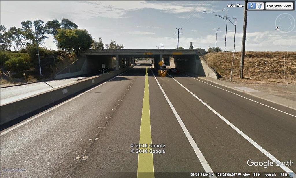
20 Last-mile connections in Sacramento, California 19

21 Station utility Based on walk time to nearest station 20

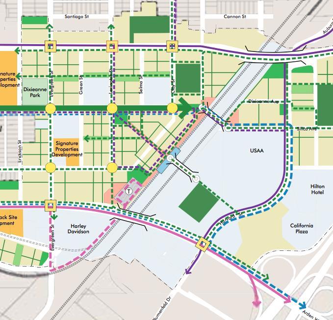
22 Station area improvements 21

23 Walk access (pedestrian bridge) Total impact (3-mile radius) 500,000 householdjobs Average Before: 4,785 jobs After: 4,794 jobs Change: 9 jobs 22

24 Walk access (bridge + freeway crossing) Total impact (3-mile radius) 2.7 million household-jobs Average Before: 4,785 jobs After: 4,832 jobs Change: 47 jobs 23

25 Transit access (bridge + freeway crossing) Total impact 29 million household-jobs Average Before: 85,180 jobs After: 85,230 jobs Change: 50 jobs 24
26 Applying Access Scores in decision-making Scan conditions Engage stakeholders Diagnose problems Predict mode share Estimate transit ridership Estimate travel demand / VMT Estimate transportation costs Track performance Assess solutions Predict outcomes 25

27 26


28 Introduction to Sugar Access

29 Easily create and test accessibility analysis scenarios 1. Select a destination category Jobs Grocery Stores Hospitals Parks and Recreation 2. Choose a time of day 3. Choose modes of travel Single Mode Walk, Bike, Drive, Transit, All
30 Access Score Calculations Accessibility: The ease (in travel time) by which travelers can reach destinations by various modes. Where do I need to travel to? What modes are available? How far am I willing to travel? What time of day am I traveling? What else affects my travel experience? 29

 - Here Schools,")
31 Where do I need to travel to? Destination Information Jobs information LODES Data Local MPO/DOT Projections Points of Interest (Non-Work Destinations) - Here Schools, Restaurants, Parks, etc Local Data 30

 Transit Developed from")
32 What modes are available? Auto All-Streets roadway network from Here Real drive times throughout day Ped Pedestrian network defined within Here network Bike Defined along both Auto and Ped network (See Bike LTS) Transit Developed from local GTFS files (headways, stops, travel times) 31
33 What time of day am I traveling? AM Peak Midday PM Peak Evening 12:00 AM 3:00 AM 6:00 AM 9:00 AM 12:00 PM 3:00 PM 6:00 PM 9:00 PM 12:00 AM Example Transit Frequency 10 Minutes 20 Minutes 10 Minutes 60 Minutes Example Roadway Speed 26 mph 40 mph 36 mph 45 mph 32


34 What time of day am I traveling? AM Peak Midday PM Peak Off- Peak 12:00 AM 3:00 AM 6:00 AM 9:00 AM 12:00 PM 3:00 PM 6:00 PM 9:00 PM 12:00 AM Jobs Accessible AM Peak Job Access Off-Peak Job Access


35 What else affects my travel experience? VS. Cyclists and Pedestrians travel based on the level of traffic stress Neighborhood Street vs. Arterial Street 25 mph vs. 45 mph 2 lane road vs. 6 lane road Protected bike lane vs. Mixed traffic biking 34


36 Sugar Access Access to Stations Before Sugar Access Understand accessibility issues at a local level Benefit of new pedestrian tunnel? 25 Minutes?

37 Sugar Access Access to Stations After Sugar Access Network Editing Capabilities Add Pedestrian or Roadway link Analyze before and after scenario 10 Minutes 36

38 Access Score Calculations Accessibility: The ease (in travel time) by which travelers can reach destinations by various modes. Where do I need to travel to? What modes are available? How far am I willing to travel? What time of day am I traveling? What else affects my travel experience? 37
39 Upcoming Webinar April 18, :00 pm Central (2:00 pm ET/Noon MT/11:00 am PT) Accessibility and Smart Scale: Using Access Scores to Prioritize Projects 38
40 Thank you! A recording of this webinar will be on the SSTI website tomorrow. mccahill@ssti.us mpettit@citilabs.com 39
Eric Sundquist Managing Director State Smart Transportation Initiative (SSTI) Urban Sustainability Accelerator
 Urban Sustainability Accelerator") New tools for making better transportation system decisions Eric Sundquist Managing Director State Smart Transportation Initiative (SSTI) Urban Sustainability Accelerator Accessibility and trip-making
New tools for making better transportation system decisions Eric Sundquist Managing Director State Smart Transportation Initiative (SSTI) Urban Sustainability Accelerator Accessibility and trip-making
Introduction to Sugar Access. Sugar Access - Measuring Accessibility (Robert Kohler, Citilabs) Slide 1 of 21
 Slide 1 of 21") Introduction to Sugar Access Sugar Access - Measuring Accessibility (Robert Kohler, Citilabs) Slide 1 of 21 Walkability, Livability, Accessibility http://www.citilabs.com/sugaraccess Sugar Access - Measuring
Introduction to Sugar Access Sugar Access - Measuring Accessibility (Robert Kohler, Citilabs) Slide 1 of 21 Walkability, Livability, Accessibility http://www.citilabs.com/sugaraccess Sugar Access - Measuring
Connecting Sacramento: A Trip-Making and Accessibility Study
 Connecting Sacramento: A Trip-Making and Accessibility Study Study Overview and Highlights July 2017 Purpose of this study Local governments and transportation agencies often make challenging decisions
October 29, Modern traffic mitigation for development in cities: Moving beyond LOS
 Modern traffic mitigation for development in cities: Moving beyond LOS October 29, 2018 Modern traffic mitigation for development in cities: Moving beyond LOS State Smart Transportation Initiative Practical
I-105 Corridor Sustainability Study (CSS)
") I-105 Corridor Sustainability Study (CSS) Metro Streets and Freeways Subcommittee March 21, 2019 Gary Hamrick Cambridge Systematics, Inc. I-105 CSS Project History & Background Funded by Caltrans Sustainable
I-105 Corridor Sustainability Study (CSS) Metro Streets and Freeways Subcommittee March 21, 2019 Gary Hamrick Cambridge Systematics, Inc. I-105 CSS Project History & Background Funded by Caltrans Sustainable
Performance measures for nonmotorized
 Performance measures for nonmotorized transportation May 2, 2014 Performance measures for non-motorized transportation Today s Speakers Robbie Webber State Smart Transportation Initiative Craig Williams
The future of city streets: NACTO Urban Street Design Guide. November 19, 2013
 The future of city streets: NACTO Urban Street Design Guide November 19, 2013 November 19, 2013 State Smart Transportation Initiative Practical Solutions to Move America Forward. A network of reform-oriented
Methodology. Reconnecting Milwaukee: A BikeAble Study of Opportunity, Equity and Connectivity
 Reconnecting Milwaukee: A BikeAble Study of Opportunity, Equity and Connectivity Released June 27, 2017 About BikeAble Rails-to-Trails Conservancy s (RTC s) BikeAble TM tool is a GIS-modeling platform
Measuring and Communicating Mobility:
 Measuring and Communicating Mobility: The District Mobility Project Stephanie Dock, District Department of Transportation TRB Transportation Issues in Major Cities Committee May 2, 2017 Deconstructing
Vision Public Workshop: Findings
 Vision Public Workshop: Findings Long Range Transportation Plan & Bicycle Mobility Plan February 2018 Vision Workshop South Kingstown 1/23/18 Providence 1/24/18 Newport 1/31/18 Long Range Transportation
Bicycle Master Plan Goals, Strategies, and Policies
 Bicycle Master Plan Goals, Strategies, and Policies Mobilizing 5 This chapter outlines the overarching goals, action statements, and action items Long Beach will take in order to achieve its vision of
Corridor Vision Workshop Summary James Madison Elementary February 22,2018
 Corridor Vision Workshop Summary James Madison Elementary February 22,2018 WHY DEVELOP THIS STUDY? Ogden City is planning for better connectivity and access to jobs and housing. Working with area partners,
Perryville TOD and Greenway Plan
 Perryville TOD and Greenway Plan Greenway Glossary Pathway: A bicycle and pedestrian path separated from motorized vehicular traffic by an open space, barrier or curb. Multi-use paths may be within the
9/25/2018. Multi-Modal Level of Service (MMLOS) Bianca Popescu, Transportation Planner
 Bianca Popescu, Transportation Planner") Multi-Modal Level of Service (MMLOS) Bianca Popescu, Transportation Planner 1 What is MMLOS? Is this a nice place to walk? Is this a nice place to bike? Is transit convenient? Bottom line - Are there options
Multi-Modal Level of Service (MMLOS) Bianca Popescu, Transportation Planner 1 What is MMLOS? Is this a nice place to walk? Is this a nice place to bike? Is transit convenient? Bottom line - Are there options
What Are The Benefits? How RIDERSHIP + Can Help You. Select RIDERSHIP + Projects
 Ridership + is a suite of regression-based direct ridership forecasting tools that harness station area built environment variables to estimate ridership on a wide variety of transit modes. What Are The
GIS Based Data Collection / Network Planning On a City Scale. Healthy Communities Active Transportation Workshop, Cleveland, Ohio May 10, 2011
 The Purpose of GIS Based Network Planning GIS Based Data Collection / Network Planning Healthy Communities Active Transportation Conference Tuesday, May 10, 2011 10:00 AM Norman Cox, LLA, ASLA. Ann Arbor,
City of Novi Non-Motorized Master Plan 2011 Executive Summary
 City of Novi Non-Motorized Master Plan 2011 Executive Summary Prepared by: February 28, 2011 Why Plan? Encouraging healthy, active lifestyles through pathway and sidewalk connectivity has been a focus
Automobile Alternatives. S. Handy TTP282 Transportation Orientation Seminar 10/28/11
 Automobile Alternatives S. Handy TTP282 Transportation Orientation Seminar 10/28/11 Why worry about them? Air quality Climate change Congestion Sprawl Equity Health U.S. Mode Split in 2001 Share of Person
Stress Bikeway Network
 Building Portland s Low- Stress Bikeway Network Photo credit: Michael Anderson Bikeportland.org Designing Streets 2015 Austin, TX October 29 2015 Roger Geller Portland Background Existing low- and lower-stress
complete streets design and construction standards public primer City of Edmonton
 complete streets design and construction standards public primer City of Edmonton introduction Complete Streets are streets for everyone: people who walk, wheel, bike, take transit, or drive. They are
Regional Bicycle Barriers Study
 Regional Bicycle Barriers Study Executive Summary Background and Purpose The 2040 Transportation Policy Plan (TPP) sets policies for planning and investment direction in the transportation system in the
Data Analysis February to March Identified safety needs from reported collisions and existing travel patterns.
 Welcome! Thank you for participating in today s Valencia Bikeway Improvements workshop. Data Analysis February to March Identified safety needs from reported collisions and existing travel patterns. Initial
Typical Rush Hour Commute. PennyforTransportation.com
 Typical Rush Hour Commute In the News Overview of the Plan Collaborative plan with projects in every community Prioritizing connectivity and congestion relief Dedicated transportation-specific funding;
Presentation Summary Why Use GIS for Ped Planning? What Tools are Most Useful? How Can They be Applied? Pedestrian GIS Tools What are they good for?
 1 2 Pedestrian GIS Tools What are they good for? Pro Walk / Pro Bike 2006 Presentation Summary Why Use GIS for Ped Planning? What Tools are Most Useful? How Can They be Applied? Matt Haynes Fehr & Peers
Rolling Out Measures of Non-Motorized Accessibility: What Can We Now Say? Kevin J. Krizek University of Colorado
 Rolling Out Measures of Non-Motorized Accessibility: What Can We Now Say? Kevin J. Krizek University of Colorado www.kevinjkrizek.org Acknowledgements Mike Iacono Ahmed El-Geneidy Chen-Fu Liao Outline
Measuring Transportation: Traffic, Mobility and Accessibility
 Measuring Transportation: Traffic, Mobility and Accessibility THIS FEATURE COMPARES THREE APPROACHES TO MEASURING TRANSPORTATION SYSTEM PERFORMANCE. TRAFFIC-BASED MEASUREMENTS EVALUATE MOTOR VEHICLE MOVEMENT;
City of Davenport CitiBus Public Transportation Study. April 2015
 City of Davenport CitiBus Public Transportation Study April 2015 Overview Project Background Key Findings CitiBus Service Allocation Policy Discussion 2 Project Background 3 About CitiBus Operates 17 routes
GIS Based Non-Motorized Transportation Planning APA Ohio Statewide Planning Conference. GIS Assisted Non-Motorized Transportation Planning
 The Purpose of GIS Assisted Network GIS Assisted Non-Motorized Transportation 2011 APA Ohio Statewide Conference Friday, 10:45 AM to Noon Focus on near-term projects wwwgreenwaycollabcom The purpose of
MN Green Step Cities December 7, Hannah Pritchard, PE PTOE
 MN Green Step Cities December 7, 2016 Hannah Pritchard, PE PTOE Hannah Pritchard PE PTOE @bicyclehannah hpritchard@tooledesign.com Choose your own adventure How we got here the history of traffic engineering
Pedestrian Activity Criteria. PSAC March 8, 2011
 Pedestrian Activity Criteria PSAC March 8, 2011 Contents 1. Project Overview a) Revised schedule of PSAC hearings 2. Pedestrian Activity: Where walking is important a) Existing conditions (revisions based
The Impact of Placemaking Attributes on Home Prices in the Midwest United States
 The Impact of Placemaking Attributes on Home Prices in the Midwest United States 2 0 1 3 C O N S T R U C T E D E N V I R O N M E N T C O N F E R E N C E M A R Y B E T H G R A E B E R T M I C H I G A N
DON MILLS-EGLINTON Mobility Hub Profile
 Mobility Hub Profile Dundas Don Mills-Eglinton West-Bloor Anchor Hub Gateway Hub N MOBILITY HUBS: Places of connectivity between regional and rapid transit services, where different modes of transportation
There are traffic jams on Highway 1
 There are traffic jams on Highway 1 How can we relieve this congestion? 2016: Year of Decision for Santa Cruz County Transportation + le b a n i sta u S + Unsu stain able Which path should we take? 2016
Overview: Phase 3 Draft Development and Circulation Plans, White Bear Station
 Overview: Phase 3 Draft Development and Circulation Plans, White Bear Station This overview explains how to get more involved and provides information on the Phase 3 draft circulation and development plans
our pedestrian future Lance Schulte
 A way to fund our pedestrian future Lance Schulte Transit Oriented District Community Facility District i t Focused on funding walking/biking/transit Lower development costs Shift auto costs to more cost
DRAFT - CITY OF MEDFORD TRANSPORTATION SYSTEM PLAN Roadway Cross-Sections
 Roadway Cross-Sections Medford s roadway cross-section standards apply to new and reconstructed roads. The crosssections take into consideration roadway function and operational characteristics, including
WALK- AND bike-friendly TURLOCK
 WALK- AND bike-friendly TURLOCK Ideas to Encourage Walking and Biking Benefits to the COMMUNITY Get Connected People who walk and bike have many more opportunities for casual interactions with friends
NEWMARKET CENTRE Mobility Hub Profile
 Mobility Hub Profile Dundas Newmarket West-Bloor Centre Anchor Hub Gateway Hub N MOBILITY HUBS: Places of connectivity between regional and rapid transit services, where different modes of transportation
What s Health Got to Do With It? Health and Land Use Planning
 What s Health Got to Do With It? Health and Land Use Planning CANDACE RUTT, PH.D. EXECUTIVE DIRECTOR APRIL 13 TH, 2016 Planning and Public Health Planning + Public Health Healthy Communities Healthier
CITY OF ALPHARETTA DOWNTOWN MASTER PLAN TRAFFIC EVALUATION
 CITY OF ALPHARETTA DOWNTOWN MASTER PLAN TRAFFIC EVALUATION June 2015 CITY OF ALPHARETTA DOWNTOWN MASTER PLAN TRAFFIC EVALUATION Introduction The Alpharetta Downtown Master Plan was developed in the fall
SETTINGS AND OPPORTUNITIES MOBILITY & ACCESS
 7 mobility & access how do people use el camino what is it like to drive on el camino/to park along el camino what is the pedestrian experience like what is the role of transit along the corridor what
Recommendations from Boston City Council Transportation Policy Briefing Series
 Recommendations from Boston City Council Transportation Policy Briefing Series Report to Boston City Councilors May 2017 Prepared by: Boston City Council Committee on Parks, Recreation & Transportation
Multimodal Analysis in the 2010 Highway Capacity Manual
 Multimodal Analysis in the 2010 Highway Capacity Manual It s not just cars anymore! Jamie Parks, AICP HCAT Conference May 9-10, 2011 Multimodal LOS in the 2010 HCM History and background Overview of methods
Regional Transportation Needs Within Southeastern Wisconsin
 Regional Transportation Needs Within Southeastern Wisconsin #118274 May 24, 2006 1 Introduction The Southeastern Wisconsin Regional Planning Commission (SEWRPC) is the official areawide planning agency
Public Works AGENDA ITEM D-2 STAFF REPORT
 AGENDA ITEM D-2 Public Works STAFF REPORT Transportation Master Plan Oversight and Outreach Committee Meeting Date: 10/30/2017 Staff Report Number: 17-001-TMP Regular Business: Provide feedback on Performance
VISION ZERO: What will it take?
 1 Through Vision Zero SF we commit to working together to prioritize street safety and eliminate traffic deaths in San Francisco. VISION ZERO: What will it take? Tom Maguire, Director, Sustainable Streets
Hennepin Avenue Reconstruction Washington Avenue to 12 th Street
 CITY OF MINNEAPOLIS Hennepin Avenue Reconstruction Washington Avenue to 12 th Street April 2016 1 Upcoming Opportunities Public Meeting #2 April 25, 2016 Minneapolis Central Library Doty Board Room Repeat
Dear City Council Members,
 From: Bob Kenyon [mailto: ] Sent: Monday, February 08, 2016 10:20 AM To: City Clerk Subject: Please prioritize Caltrain and a complete transit network Thank you for prioritizing bringing BART to San Jose
Complete Streets Workshop Follow-up. April 27, 2011 Rockledge City Hall
 Complete Streets Workshop Follow-up April 27, 2011 Rockledge City Hall Agenda Complete Streets draft briefing presentation and sample policy language Share your Complete Streets projects and post workshop
Arterial Transitway Corridors Study. Ave
 Arterial Transitway Corridors Study Ave January 2012 Arterial Transitway Corridors Study Overview Corridor Features and Demographics 11 study corridors, 95 route miles 86,000 daily rides and half of existing
DOWNTOWN MIAMI PEDESTRIAN PRIORITY ZONE
 DOWNTOWN MIAMI PEDESTRIAN PRIORITY ZONE AUGUST 6, 2013 DOWNTOWN MIAMI BY THE NUMBERS more than 200,000 people live, work, and play here every day is home to more than 1,000 events each year hosts more
Gina M. M. Thomas. HDR, Transit Engineer Seattle, WA
 Tucson Streetcar: A Success Story How a streetcar project helped to re-establish a sense of place for the Tucson community Gina M. M. Thomas P.E., LEED A.P., ENV S.P. HDR, Transit Engineer Seattle, WA
METRO Light Rail: Changing Transit Markets in the Phoenix Metropolitan Area
 METRO Light Rail: Changing Transit Markets in the Phoenix Metropolitan Area Abhishek Dayal, AICP Planner III, METRO Light Rail Phoenix, AZ BACKGROUND Transit in the Phoenix Region Transit services in the
Multimodal Transportation Plan
 Multimodal Transportation Plan The Multimodal Transportation Plan will accommodate MILLENIALS ARE DRIVING LESS. WE CANNOT BUILD OUR WAY all modes of transportation by keeping pedestrians, OUT OF CONGESTION.
Appendix A-K Public Information Centre 2 Materials
 Appendix A-K Public Information Centre 2 Materials Our Rapid Transit Initiative Make an impact on the future of transit Join the discussion on Rapid Transit in London You re invited to a Public Information
ABOUT THIS STUDY The Tenderloin-Little Saigon Community-Based Transportation Plan
 ABOUT THIS STUDY The Tenderloin-Little Saigon Community-Based Transportation Plan The Greater Tenderloin Community Study Milestones October Community based organizations (Tenderloin Housing Clinic and
Intermodal Connections with Light Rail in Phoenix, AZ Wulf Grote, P.E. Director, Planning & Development
 Intermodal Connections with Light Rail in Phoenix, AZ Wulf Grote, P.E. Director, Planning & Development 12th National LRT Conference Salt Lake City, UT November 12, 2012 Outline METRO Light Rail Overview
Agency Advisory Group Meeting #3 and Walk Audit Anchorage Non-Motorized Plan
 Agency Advisory Group Meeting #3 and Walk Audit Anchorage Non-Motorized Plan Friday, May 18 th Walk Audit 10:00-11:30 AM Meeting 11:30 AM 1:00 PM Municipal Planning Department, 4700 Elmore Road, Training
WALKNBIKE DRAFT PLAN NASHVILLE, TENNESSEE EXECUTIVE SUMMARY NASHVILLE, TENNESSEE
 NASHVILLE, TENNESSEE EXECUTIVE SUMMARY Executive Summary A world-class multi-modal transportation system is essential to a vibrant city and better quality of life. -Mayor Barry The WalknBike plan aims
Bridgewater Complete Streets Prioritization Plan and Pedestrian Safety Assessment
 Bridgewater Complete Streets Prioritization Plan and Pedestrian Safety Assessment Presented by Luciano Rabito Manager of Complete Streets Presented to Bridgewater, MA Wednesday, April 26, 2017 6:30 P.M.
Built Environment Childhood Obesity Forum September 15, 2010
 Built Environment Childhood Obesity Forum September 15, 2010 TITLE Why do we have cities? Boston MA To minimize travel & maximize exchange (bring people closer together) How have we built our urban roadway
EXECUTIVE SUMMARY. Vision
 Vision Walking and bicycling in Salt Lake City will be safe, convenient, comfortable, and viable transportation options that connect people to places, foster recreational and economic development opportunities,
City of Jacksonville Mobility Fee Update
 City of Jacksonville Mobility Fee Update 2017 Preliminary Analysis May 3, 2017 Carnival Cruise lines photo credit Presentation Overview Public Outreach Process Pedestrian and Bicycle Master Plan Study
As a part of the San Mateo Bicycle Master Plan update, Toole Design conducted a needs and demand analysis that included:
 To: Sue-Ellen Atkinson and Henry Choi, City of San Mateo From: Megan Wooley-Ousdahl, Laura Krull, and Jess Zdeb, Toole Design Date: March 1, 2019 Project: San Mateo Bicycle Master Plan Subject: Needs and
DON MILLS-SHEPPARD Mobility Hub Profile
 DON MILLS-SHEPPARD Mobility Hub Profile Dundas Don Mills-Sheppard West-Bloor Anchor Hub Gateway Hub N MOBILITY HUBS: Places of connectivity between regional and rapid transit services, where different
ROADSOADS CONGESTION HAMPTON SYSTEMYSTEM MANAGEMENT. Part II Roadway Congestion Analysis Mitigation Strategies and Evaluation
 HAMPTON ROADSOADS CONGESTION MANAGEMENT SYSTEMYSTEM Part II Roadway Congestion Analysis Mitigation Strategies and Evaluation Presented by: Dwight Farmer, PE Deputy Executive Director, Transportation April
Guidelines for Providing Access to Public Transportation Stations APPENDIX C TRANSIT STATION ACCESS PLANNING TOOL INSTRUCTIONS
 APPENDIX C TRANSIT STATION ACCESS PLANNING TOOL INSTRUCTIONS Transit Station Access Planning Tool Instructions Page C-1 Revised Final Report September 2011 TRANSIT STATION ACCESS PLANNING TOOL INSTRUCTIONS
Non-Motorized Transport (NMT) Development. Gerald Ollivier Transport Cluster Leader Transport Global Practice The World Bank
 Development. Gerald Ollivier Transport Cluster Leader Transport Global Practice The World Bank") Non-Motorized Transport (NMT) Development Gerald Ollivier Transport Cluster Leader Transport Global Practice The World Bank In China, national plan and policy prioritize NMT development The 13 th Five
Non-Motorized Transport (NMT) Development Gerald Ollivier Transport Cluster Leader Transport Global Practice The World Bank In China, national plan and policy prioritize NMT development The 13 th Five
Is St. Louis Ready for a Bike Share System? May 14, 2014 Public Open House
 Is St. Louis Ready for a Bike Share System? May 14, 2014 Public Open House PRESENTATION AGENDA 2 BIKE SHARE How does it work? What are the benefits? Who would use it? Will it be safe? Would it work in
TRANSPORTATION & MOBILITY VISIONING MEETING. August 23 24, 2017
 TRANSPORTATION & MOBILITY VISIONING MEETING August 23 24, 2017 Project Team 1999 South Lakefront Framework Plan In 1999, the Chicago Park District authorized framework plans for three historic parks: Jackson,
APPENDIX E BIKEWAY PRIORITIZATION METHODOLOGY
 APPENDIX E BIKEWAY PRIORITIZATION METHODOLOGY INTRODUCTION The network of bikeways recommended in the Bicycle Master Plan is extensive and is likely to be only partially completed during the 25-year life
Magnolia Place. Traffic Impact Analysis. Prepared for: City of San Mateo. Prepared by: Hexagon Transportation Consultants, Inc.
 Magnolia Place Traffic Impact Analysis Prepared for: City of San Mateo Prepared by: Hexagon Transportation Consultants, Inc. Updated January 4, 2010 Table of Contents 1. Introduction...1 2. Existing Conditions...6
95 th Street Corridor Transportation Plan. Steering Committee Meeting
 95 th Street Corridor Transportation Plan Steering Committee Meeting August 11, 2014 PROJECT OBJECTIVES Develop a Transportation and Economic Plan for the 95 th Street Corridor Improve public transit efficiency
SoundCast Design Intro
 SoundCast Design Intro Basic Design SoundCast and Daysim 3 Land use attributes Households & Individuals SoundCast DaySim Travel demand simulator Trips and Households, Excel Summary Sheets, EMME network
NACTO Designing Cities 2014 Dongho Chang, City Traffic Engineer October 23, 2014
 NACTO Designing Cities 2014 Dongho Chang, City Traffic Engineer October 23, 2014 Presentation overview Perspective on Safety Changing needs of our cities How Seattle is meeting those needs Challenge for
Speed Limits Study and Proposal. Public Input Session: 8/14/13
 Speed Limits Study and Proposal Public Input Session: 8/14/13 Why is Decatur a unique place for this project? First Community Transportation Plan in the nation with a Health Impact Assessment. Strong sense
CONNECTING PEOPLE TO PLACES
 CONNECTING PEOPLE TO PLACES 82 EAST BENCH MASTER PLAN 07 Introduction The East Bench transportation system is a collection of slow moving, treelined residential streets and major arteries that are the
Metropolitan Council Transportation Committee
 Nicollet-Central Transit Alternatives Metropolitan Council Transportation Committee August 2013 Project Purpose (approved by Policy Advisory Committee 10/25/2012) The purpose is to improve transit connectivity,
SANTA CLARA COUNTYWIDE BICYCLE PLAN August 2008
 SANTA CLARA COUNTYWIDE BICYCLE PLAN August 2008 To assist VTA and Member Agencies in the planning, development and programming of bicycle improvements in Santa Clara County. Vision Statement To establish,
Sacramento Grid 2.0. The Downtown Transportation Study
 Sacramento Grid 2.0 The Downtown Transportation Study April 20, 2016 The Grid 4.25 square miles Street grid defined at birth of City Lettered and numbered streets spaced every 400 ft East-west alleys halfway
North Shore Transportation Improvement Strategy
 North Shore Transportation Improvement Strategy Preliminary, Near-term Recommendation 2016 April Transportation Improvement Strategy (TIS) Comprehensive and Analytical A multi-modal transportation strategy
Appendix C 3. Bicycle / Pedestrian Planning
 Appendix C 3. Bicycle / Pedestrian Planning BICYCLE/PEDESTRIAN PLANNING 2005 Master Plan GOAL: Provide for safe and convenient bicycle and pedestrian circulation throughout the City. Develop a city-wide
Project Team. Refined Pedestrian Crossing Toolbox. Problem Statement. Aerial of Study Corridor. Crossing Accommodations and Pedestrian Fatalities
 Project Team Refined Pedestrian Crossing Toolbox Treatments on Wide, High Speed Urban Roadways Developed as Part of the Springfield Main Street (OR 126) Safety Study Consultants Scott Mansur, P.E., P.T.O.E.
Defining Purpose and Need
 Advanced Design Flexibility Pilot Workshop Session 4 Jack Broz, PE, HR Green May 5-6, 2010 Defining Purpose and Need In your agency s project development process, when do design engineers typically get
Attachment A: Columbus Area Metropolitan Transportation Plan Objectives, Performance Measures, and Targets
 OBJECTIVE: Reduce the percentage of commuters driving alone, and increase the percentage of commuters riding transit, ing Reducing single occupancy auto commutes and increasing commuters using alternative
BUILDING THE CASE FOR TRAVEL OPTIONS IN WASHING TON COUNTY. Image: Steve Morgan. Image: Steve Morgan
 BUILDING THE CASE FOR TRAVEL OPTIONS IN WASHING TON COUNTY Image: Steve Morgan Image: Steve Morgan Image: TriMet Image: TriMet WHAT ARE TRAVEL OPTIONS PROGRAMS? Travel options programs encourage residents,
BEAR CREEK PARK AND RIDE
 BEAR CREEK PARK AND RIDE 7760 178th Pl NE, Redmond, WA 98052 700 Average weekday transit boardings 283 Parking spaces Owned by King County Metro Served by Sound Transit and King County Metro Bear Creek
PRELIMINARY DRAFT FIRST AMENDMENT TO VISION 2050: A REGIONAL LAND USE AND TRANSPORTATION PLAN FOR SOUTHEASTERN WISCONSIN
 PRELIMINARY DRAFT FIRST AMENDMENT TO VISION 2050: A REGIONAL LAND USE AND TRANSPORTATION PLAN FOR SOUTHEASTERN WISCONSIN ESTABLISHING TARGETS FOR FEDERAL PERFORMANCE MEASURES: HIGHWAY SAFETY SOUTHEASTERN
5858 N COLLEGE, LLC N College Avenue Traffic Impact Study
 5858 N COLLEGE, LLC nue Traffic Impact Study August 22, 2016 Contents Traffic Impact Study Page Preparer Qualifications... 1 Introduction... 2 Existing Roadway Conditions... 5 Existing Traffic Conditions...
This document may be reprinted or extracted without permission, provided credit to the City of Pasadena Department of Transportation
 TRANSPORTATION IMPACT ANALYSIS CURRENT PRACTICE & GUIDELINES Prepared by: Transportation Complete Streets Division Department of Transportation 20150925 This document may be reprinted or extracted without
Arterial Transitway Corridors Study
 Arterial Transitway Corridors Study February 2012 Arterial Transitway Corridors Study Overview Corridor Features and Demographics 11 study corridors, 95 route miles Routes: 86,000 daily rides and half
Appendix F: Detailed Modeling Results
 Appendix F: Detailed Modeling Results TransAction Technical Report (This page intentionally left blank) METHODOLOGY FOR CALCULATION OF PERFORMANCE MEASURES F-3 (This page intentionally left blank) Approved
Measuring Success: Performance Metrics and Project Selection
 Measuring Success: Performance Metrics and Project Selection Fayetteville Mobility Plan Presented by: Jeffrey Tumlin March 19, 2018 How do we use transportation performance metrics? Improving efficiency
PEDALING FORWARD. A Glance at the SFMTA s Bike Program for SFMTA.COM
 PEDALING FORWARD A Glance at the SFMTA s Bike Program for 2017-2021 SFMTA.COM INTRODUCTION About This Booklet More people from all walks of life see their bicycle as a more convenient way to get where
Markham Sports, Entertainment and Cultural Centre Transportation Overview
 Markham Sports, Entertainment and Cultural Centre Transportation Overview ARENA LOCATION 2 3 TRANSPORTATION VISION IN MARKHAM On April 12, 2011, Markham Council adopted a long-term Transportation Vision
Montford Drive Parking & Circulation Study
 Montford Drive Parking & Circulation Study Parking & Circulation Study Follow up to the Area Plan based on what we heard Purpose 1 2 3 4 To look closer and evaluate parking and network related issues (including
New Seward and 36 th Avenue Intersection Conceptual Design
 University of Alaska Anchorage New Seward and 36 th Avenue Intersection Conceptual Design Prepared By: Zaid S. Hussein Dana Menendez Galen Jones Civil Engineering Department Prof. Osama Abaza CE A404 Highway
Transforming Traffic Signals to Support Sustainability: Applications, Ideas, & Research
 Transforming Traffic Signals to Support Sustainability: Applications, Ideas, & Research MARCH 4, 2011 Presented by: Peter Koonce, PE Division Manager, City of Portland Signals, Street Lighting, & ITS Overview
PERFECT WAVES ON DEMAND
 PERFECT WAVES ON DEMAND MASTERING THE DESIGN, DEVELOPMENT, AND OPERATION OF SURF ATTRACTIONS WORLDWIDE OUR MISSION To share surfing s aloha spirit and make perfect surfing waves accessible to anyone, anytime,
Route 7 Corridor Study
 Route 7 Corridor Study Executive Summary Study Area The following report analyzes a segment of the Virginia State Route 7 corridor. The corridor study area, spanning over 5 miles in length, is a multi