Designing a Bicycle and Pedestrian Count Program in Blacksburg, VA
|
|
|
- Jeffery Lynch
- 5 years ago
- Views:
Transcription
 Andrew Mondschein (U or Virginia) Ralph Buehler (Virginia Tech)")
1 Designing a Bicycle and Pedestrian Count Program in Blacksburg, VA Steve Hankey (Virginia Tech) Andrew Mondschein (U or Virginia) Ralph Buehler (Virginia Tech)
2 Issue/objective Issue No systematic traffic monitoring of bikes/peds Traffic counts important for planning and funding decisions Objective Implement a bike/ped monitoring program: Proof-of-concept Sample ~10% of the network and estimate traffic for all street segments Project Team Steve Hankey (PI), Andrew Mondschein (Co-PI), Ralph Buehler (Co-PI) Graduate students: Tianjun Lu, Kyle Lukacs Community partners: Town of Blacksburg 2
3 Approach Objective: Systematic Count Program Task 1: Validation of automated counters Task 2: Site selection and data collection Task 3: Estimate AADT for all count sites Task 4: Spatial models to estimate AADT across network Pneumatic tubes (bike; streets) Passive Infrared (ped; sidewalks) Radiobeam (bike & ped; trails) Reference sites (n = 4; full year) Short-duration sites (n = 97; 1-week) Impute missing data (ref. sites) Make scaling factors (ref. sites) & apply (short-duration sites) Tabulate land use variables at count sites Build direct-demand models of traffic 3


")
")
4 Task 1: Counter Validation ~240 hours of validation counts Component of graduate course Develop correction equations MetroCount pneumatic tube counter (n=12) Eco-counter Pyro passive infrared counter (n=10) RadioBeam bicycle-people counter (n=3) 4
5 Manual Count Manual Count Manual Count Manual Count Task 1: Correction equations Good fit with linear correction (mostly) Correction varies by counter Polynomial fit may be needed at higher volumes More data at high volume sites would be helpful Pneumatic Tubes Polynomial R² = 0.90 Linear R² = Automated Count Infrared Polynomial R² = 0.97 Linear R² = Automated Count Radiobeam: Bike Linear R² = Automated Count Radiobeam: Ped Linear R² = Automated Count


6 Task 2: Site selection Full year of data Seasonal and daily patterns Variety of location types 1 week of data Good spatial coverage Systematic selection 6


7 Task 2: Stratified, pseudo-random selection Total: 29% Bike lane: 10% No facility: 19% Total: 51% Bike buildout: 36% Low centrality: 15% Total: 20% Trail transport: 10% Trail neighborhood: 10% 7

8 Task 2: Final count locations 8

9 Task 2: Data collection Questions for sampling design How to scale short-duration counts? How long to count at each site? What time of season to count? Case Study: Minneapolis 9
10 Task 2: Data collection - Scaling Approach 1: Traditional Approach 2: New 10
11 Mean absolute AADT error Task 2: Data collection Length of count 40% Traditional Old scaling method scaling method New scaling method 30% 20% 10% 0% Number of short-duration sampling days 11

12 Task 2: Data collection Season of count 12
13 Task 2: Summary of sampling campaign 1-week short duration counts (n=97) April October 10% random re-sample of locations Event log and statistical check used to clean data 13
14 Task 3: Estimate AADT at all count sites Weather and temporal variables Valid data at reference sites Negative binomial regression models Impute missing data and estimate AADT Day-of-Year scaling factors 1-week counts (short-duration sites) AADT (short-duration sites) 14
15 Task 3: Generate scaling factors 3 Bicycle Day-of-Year Scaling Factors 2 Estimated AADT for reference sites 1 Draper College Giles Huckleberry Bike AADT Ped AADT 98 4, Jan 1 Feb 22 April 15 June 6 July 28 Sep 18 Nov 9 Dec 31 3 Pedestrian Day-of-Year Scaling Factors Jan 1 Feb 22 April 15 June 6 July 28 Sep 18 Nov 9 Dec 31 14

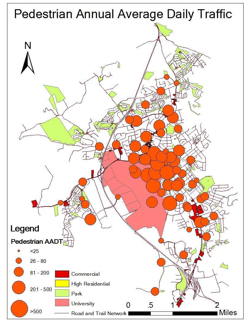
16 Task 3: Map AADT 16
17 Task 3: AADT by road type and bicycle facility Bicycle AADT * * Bicycle AADT: * indicates statistical significance compared to a road w/o a bike lane (p<0.05) Pedestrian AADT: Traffic is higher on local roads. Likely due to roads on VT campus classified as local Road without bike lane Road with bike lane Trail tranport Trail neighborhood Pedestrian AADT Local road Major road Trail tranport Trail neighborhood

18 Task 4: Direct-demand models Goal 1: Determine predictors (land use and infrastructure) of active travel. Goal 2: Estimate spatial patterns of bicycle and pedestrian traffic for exposure assessment. Bike/ped counts Facility-demand models 18
. 3. Select predictor variables most correlated with traffic volumes. 4. Keep only variables that improve model. a) Statistical significance (p-value) b) Multi-collinearity (VIF) 5.")
19 Task 4: Stepwise regression modelbuilding 1. Compile database of candidate predictor variables. 2. Tabulate each variable at many geographic scales (network buffers; 100 3,000 meters). 3. Select predictor variables most correlated with traffic volumes. 4. Keep only variables that improve model. a) Statistical significance (p-value) b) Multi-collinearity (VIF) 5. Reasonable model fit (adj-r 2 ). a) Fully specified models: b) Reduced-form models:
20 Task 4: Preliminary model results Total variables (n=133) Variables (n=12) Buffers (n=11); 100 3,000 m Transportation All roads, Off-street trail, On-street facility, Intersections, Centrality Land use Retail, Industry, Open space, Employment density Population House/Pop density, HH income Total selected (n=14); 11% Most commonly selected... Variable Number selected Pop Density 4 Off-street trail 3 Retail 2 Centrality 2 Employment 2 All roads 2 Bike lane, Income, Open space 28% selected at <250 meters 1 20
21 Task 4: Next steps for direct-demand models Add other variables Update for VT campus Non-residential address, tree cover, bus stops, sidewalks, major/local roads Finalize core models for bike and ped traffic Extrapolate estimates to all street segments 21
22 Summary and future work Summary of work Successfully implemented systematic count campaign in Blacksburg Developed proof-of-concept for estimating AADT Developed tool for estimating AADT at locations without counts Cost: ~$60,000 (equipment) plus 1.5 year of 20-hour/wk graduate student (~$50,000) Future work Hour-of-day direct-demand models Test method in other (i.e., larger) communities Work with Town of Blacksburg to: Assess buildout of bike/ped network Evaluate investments 22

23 Thanks and contact info Project Team Steve Hankey (PI), Andrew Mondschein (Co-PI), Ralph Buehler (Co-PI) Graduate students: Tianjun Lu, Kyle Lukacs Community partners: Town of Blacksburg Contact Steve Hankey Urban Affairs and Planning, Virginia Tech
FINAL REPORT. Designing a Bicycle and Pedestrian Traffic Count Program to Estimate Performance Measures on Streets and Sidewalks in Blacksburg, VA
 FINAL REPORT Designing a Bicycle and Pedestrian Traffic Count Program to Estimate Performance Measures on Streets and Sidewalks in Blacksburg, VA Date: May 216 Steve Hankey, PhD, Assistant Professor, Virginia
Designing a Bicycle and Pedestrian Traffic Monitoring Program to Estimate Annual Average Daily Traffic in a Small Rural College Town
 Lu, Buehler, Mondschein & Hankey 1 Designing a Bicycle and Pedestrian Traffic Monitoring Program to Estimate Annual Average Daily Traffic in a Small Rural College Town Tianjun Lu School of Public and International
Active Travel and Exposure to Air Pollution: Implications for Transportation and Land Use Planning
 Active Travel and Exposure to Air Pollution: Implications for Transportation and Land Use Planning Steve Hankey School of Public and International Affairs, Virginia Tech, 140 Otey Street, Blacksburg, VA
Temporal and Spatial Variation in Non-motorized Traffic in Minneapolis: Some Preliminary Analyses
 Temporal and Spatial Variation in Non-motorized Traffic in Minneapolis: Some Preliminary Analyses Spencer Agnew, Jason Borah, Steve Hankey, Kristopher Hoff, Brad Utecht, Zhiyi Xu, Greg Lindsey Thanks to:
Ben Timerson, MnDOT Erik Minge, SRF Consulting Group Greg Lindsey, University of Minnesota
 Ben Timerson, MnDOT Erik Minge, SRF Consulting Group Greg Lindsey, University of Minnesota 2050 Vision Minnesota Go Multimodal transportation system maximizes the health of people, the environment and
PBIC Webinar. Pedestrian and Bicycle Count Data Part I Programs, Data and Metrics
 PBIC Webinar Pedestrian and Bicycle Count Data Part I Programs, Data and Metrics Krista Nordback UNC Highway Safety Research Center Jeremy Raw Federal Highway Administration Scott Brady Delaware Valley
2017 Northwest Arkansas Trail Usage Monitoring Report
 2017 Northwest Arkansas Trail Usage Monitoring Report Summary Findings: The study showed that average daily weekday bicycle volumes per study site increased by about 32% between 2015 and 2017, from 142
Presentation Summary Why Use GIS for Ped Planning? What Tools are Most Useful? How Can They be Applied? Pedestrian GIS Tools What are they good for?
 1 2 Pedestrian GIS Tools What are they good for? Pro Walk / Pro Bike 2006 Presentation Summary Why Use GIS for Ped Planning? What Tools are Most Useful? How Can They be Applied? Matt Haynes Fehr & Peers
Summary of NWA Trail Usage Report November 2, 2015
 Summary of NWA Trail Usage Report November 2, 2015 Summary Findings: The study showed that Northwest Arkansas (NWA) had relatively high cyclist user counts per capita aggregated across the top three usage
Counting Pedestrians and. and Other Facilities
 Counting Pedestrians and Cyclists on Multiuse Trails and Other Facilities Trail Counting Workshop How many are researchers? How many are policy-makers, public managers, or advocates? How many are now counting
Neighborhood Influences on Use of Urban Trails
 Neighborhood Influences on Use of Urban Trails Greg Lindsey, Yuling Han, Jeff Wilson Center for Urban Policy and the Environment Indiana University Purdue University Indianapolis Objectives Present new
Methods and Technologies for Pedestrian and Bicycle Volume Data Collection NCHRP 7-19
 Methods and Technologies for Pedestrian and Bicycle Volume Data Collection NCHRP 7-19 ITS Maryland 2013 Annual Meeting Kelly M. Laustsen October 8, 2013 1 MOVING FORWARD THINKING Presentation Overview
For Information Only. Pedestrian Collisions (2011 to 2015) Resolution. Presented: Monday, Apr 18, Report Date Tuesday, Apr 05, 2016
 Resolution. Presented: Monday, Apr 18, Report Date Tuesday, Apr 05, 2016") Presented To: Operations Committee For Information Only Pedestrian Collisions (0 to 0) Presented: Monday, Apr 8, 06 Report Date Tuesday, Apr 0, 06 Type: Correspondence for Information Only Resolution For
Presented To: Operations Committee For Information Only Pedestrian Collisions (0 to 0) Presented: Monday, Apr 8, 06 Report Date Tuesday, Apr 0, 06 Type: Correspondence for Information Only Resolution For
CONCERNS / CHALLENGES
 CONCERNS / CHALLENGES Time frame Transit Pedestrian Access & Comfort Bicycle Access & Comfort Neighborhood Spillover Public Info & Signange Connection to Downtown Physical Contraints of site 0-5 years
Four Approaches to Starting a Successful Bike / Ped Counting Program
 Four Approaches to Starting a Successful Bike / Ped Counting Program 9/6/2018 Jean-Francois Rheault, Eco-Counter for 2018 Joint Policy Conference: Connecting the DOTs What is the Eco-Counter perspective?
WALKNBIKE DRAFT PLAN NASHVILLE, TENNESSEE EXECUTIVE SUMMARY NASHVILLE, TENNESSEE
 NASHVILLE, TENNESSEE EXECUTIVE SUMMARY Executive Summary A world-class multi-modal transportation system is essential to a vibrant city and better quality of life. -Mayor Barry The WalknBike plan aims
Use of Direct-Demand Modeling in Estimating Nonmotorized Activity: A Meta-analysis
 Use of Direct-Demand Modeling in Estimating Nonmotorized Activity: A Meta-analysis Project Number: UTC Safe-D 01-003 Project Title: Data Mining to Improve Planning for Pedestrian and Bicyclist Safety Sirajum
GIS Based Data Collection / Network Planning On a City Scale. Healthy Communities Active Transportation Workshop, Cleveland, Ohio May 10, 2011
 The Purpose of GIS Based Network Planning GIS Based Data Collection / Network Planning Healthy Communities Active Transportation Conference Tuesday, May 10, 2011 10:00 AM Norman Cox, LLA, ASLA. Ann Arbor,
Webinar: Development of a Pedestrian Demand Estimation Tool
 Portland State University PDXScholar TREC Webinar Series Transportation Research and Education Center (TREC) 2-18-2016 Webinar: Development of a Pedestrian Demand Estimation Tool Kelly Clifton Portland
GIS Based Non-Motorized Transportation Planning APA Ohio Statewide Planning Conference. GIS Assisted Non-Motorized Transportation Planning
 The Purpose of GIS Assisted Network GIS Assisted Non-Motorized Transportation 2011 APA Ohio Statewide Conference Friday, 10:45 AM to Noon Focus on near-term projects wwwgreenwaycollabcom The purpose of
Bicycle and Pedestrian Traffic Monitoring and AADT Estimation in a Small Rural College Town Tianjun Lu. Steve Hankey, Chair Ralph Buehler Yang Zhang
 Bicycle and Pedestrian Traffic Monitoring and AADT Estimation in a Small Rural College Town Tianjun Lu Thesis submitted to the faculty of the Virginia Polytechnic Institute and State University in partial
This page intentionally left blank.
 This page intentionally left blank. COMMUNITY Coweta Community Overview Coweta Coweta, a residential community located in Wagoner County, is a suburb of Tulsa situated southeast of the metropolitan area
Bicycle and Pedestrian Planning in a Historically Car-Centric Culture: A Focus on Connectivity, Safety, & Accessibility
 Bicycle and Pedestrian Planning in a Historically Car-Centric Culture: A Focus on Connectivity, Safety, & Accessibility Kate Horton and Zylavian Watley Transportation Planners Memphis MPO Date: October
Do New Bike Share Stations Increase Member Use?: A Quasi-Experimental Study
 Do New Bike Share Stations Increase Member Use?: A Quasi-Experimental Study Jueyu Wang & Greg Lindsey Humphrey School of Public Affairs University of Minnesota Acknowledgement: NSF Sustainable Research
We All Count: Collaboratively Collecting & Using Biking and Walking Data in Minnesota. Agenda. Why collect info about people biking and walking?
 We All Count: Collaboratively Collecting & Using Biking and Walking Data in Minnesota Michael Petesch Pedestrian and Bicycle Data Coordinator Agenda Why collect info about people biking and walking? How
Transportation Planning Division
 Transportation Planning Division Presentation Outline Study Tasks Recap of Previous Meeting Stakeholder Interviews Data Collection Design Principles Tool Box Recommendations Schedule Moving Forward North
Application of Demographic Analysis to Pedestrian Safety. Center for Urban Transportation Research University of South Florida
 Application of Demographic Analysis to Pedestrian Safety BDV25 TWO 977 30 Pei Sung Lin, Ph.D., P.E., PTOE, FITE Program Director Achilleas Kourtellis, Ph.D. Senior Research Associate CUTR, University of
Safety & Convenience for All Users, in All Modes. Barbara McCann NCSL December 3, 2013
 Safety & Convenience for All Users, in All Modes Barbara McCann NCSL December 3, 2013 Safety & Convenience for All Users? Who was left out when this road was planned? Takaaki Iwabu for Raleigh News Observer
EXECUTIVE SUMMARY... vii 1 STUDY OVERVIEW Study Scope Study Area Study Objectives
 Contents EXECUTIVE SUMMARY... vii 1 STUDY OVERVIEW... 1-1 1.1 Study Scope... 1-1 1.2 Study Area... 1-1 1.3 Study Objectives... 1-3 2 EXISTING CONDITIONS... 2-1 2.1 Existing Freeway Conditions... 2-4 2.1.1
ADOT Statewide Bicycle and Pedestrian Program Summary of Phase IV Activities APPENDIX B PEDESTRIAN DEMAND INDEX
 ADOT Statewide Bicycle and Pedestrian Program Summary of Activities APPENDIX B PEDESTRIAN DEMAND INDEX May 24, 2009 Pedestrian Demand Index for State Highway Facilities Revised: May 29, 2007 Introduction
Public Workshop #2. September 14, 2016
 Public Workshop #2 September 14, 2016 Agenda Welcome Project Overview Where We Have Been Alternatives for State Street Land Use Street Design Next Steps 2 Project Overview Create a Vibrant State Street
Update on Regional Bicycle, Pedestrian, & Trail Planning. Presented to TCC November 21, 2014
 Update on Regional Bicycle, Pedestrian, & Trail Planning Presented to TCC November 21, 2014 Survey Measure Assess Focus Area Performance- Driven Process Policy Policy Implement Plan Criteria Criteria Criteria
Do New Bike Share Stations Increase Member Use?: A Quasi-Experimental Study
 Do New Bike Share Stations Increase Member Use?: A Quasi-Experimental Study Jueyu Wang & Greg Lindsey Humphrey School of Public Affairs University of Minnesota Acknowledgement: NSF Sustainable Research
Highway 111 Corridor Study
 Highway 111 Corridor Study June, 2009 LINCOLN CO. HWY 111 CORRIDOR STUDY Draft Study Tea, South Dakota Prepared for City of Tea Sioux Falls Metropolitan Planning Organization Prepared by HDR Engineering,
NON-MOTORIZED TRANSPORTATION MONITORING PROGRAM
 NON-MOTORIZED TRANSPORTATION MONITORING PROGRAM Ohio Transportation Engineering Conference October 28 th, 2015 Presentation Content: Program Overview Manual Counts Automatic Counts Data storage Information
Sixth Line Development - Transit Facilities Plan
 Memorandum Date: November 13, 2012 To: From: c.c. Subject: Rob Freeman (Freeman Planning) Kevin Phillips Sixth Line Development - Transit Facilities Plan 33016631 This memo was prepared to review the transit
Plant City Bicycle and Pedestrian Master Plan. Project Update March 2, 2017
 Plant City Bicycle and Pedestrian Master Plan Project Update March 2, 2017 NOV Project Kickoff DEC/ JAN FEB/ MAR Plan Review/Field Work Public Meeting/Coordination Meetings Develop Draft Plan APR/ MAY
Bicycle and Pedestrian Connectivity Study. Old Colony Planning Council
 Bicycle and Pedestrian Connectivity Study Old Colony Planning Council Outline Why consider bike/peds in road designs? Why are measures needed? Connecting Land Use with Transportation Evaluation Tools:
Goodlettsville Bicycle and Pedestrian Plan Executive Summary
 Goodlettsville Bicycle and Pedestrian Plan July 2010 In Cooperation with the Nashville Area Metropolitan Planning Executive Organization Summary Introduction Progressive and forward thinking communities
Bicycle and Pedestrian
 Bicycle and Pedestrian Planning for Bikeable and Walkable Communities W H O L E H E A L T H C O N F E R E N C E 0 3 / 2 2 / 2 0 1 6 R O Y G O T H I E P E N N D O T B I C Y C L E - P E D E S T R I A N C
VGI for mapping change in bike ridership
 VGI for mapping change in bike ridership D. Boss 1, T.A. Nelson* 2 and M. Winters 3 1 Unviersity of Victoria, Victoria, Canada 2 Arizona State University, Arizona, USA 3 Simon Frasier University, Vancouver,
Sandra Nutter, MPH James Sallis, PhD Gregory J Norman, PhD Sherry Ryan, PhD Kevin Patrick, MD, MS
 Objectively Measured Environmental Correlates of Adolescent Physical Activity Sandra Nutter, MPH James Sallis, PhD Gregory J Norman, PhD Sherry Ryan, PhD Kevin Patrick, MD, MS San Diego State University
Traffic Safety Barriers to Walking and Bicycling Analysis of CA Add-On Responses to the 2009 NHTS
 Traffic Safety Barriers to Walking and Bicycling Analysis of CA Add-On Responses to the 2009 NHTS NHTS Users Conference June 2011 Robert Schneider, Swati Pande, & John Bigham, University of California
Chapter 5 Future Transportation
 Chapter 5 Future Transportation The Future Land Use Plan identifies the desired land use designations. The land uses desired for Crozet depend, in large part, on the success of the transportation system,
Bicycle Friendly Niagara Falls
 Bicycle Friendly Niagara Falls STAKEHOLDER COMMITTEE MEETING 2 SUPPORTED BY THE OATH COMMUNITY FUND AT THE COMMUNITY FOUNDATION FOR GREATER BUFFALO Develop a Bicycle Master Plan to document the city s
Cycling Volume Estimation Methods for Safety Analysis
 Cycling Volume Estimation Methods for Safety Analysis XI ICTCT extra Workshop in Vancouver, Canada Session: Methods and Simulation Date: March, 01 The Highway Safety Manual (HSM) documents many safety
Physical Implications of Complete Streets Policies
 Presentation Overview Physical Implications of Complete Norm Cox, ASLA, LLA Landscape Architect Ann Arbor, Michigan, 10:45 to Noon What Are Complete Streets? What Matters to Bicyclists and Pedestrians
Title of the proposed project Development of a Toolbox for Evaluation and Identification of Urban Road Safety Improvement Measures
 Centre of Excellence (CoE) in Urban Transport Department of Civil Engineering, IIT Madras Title of the proposed project Development of a Toolbox for Evaluation and Identification of Urban Road Safety Improvement
Methodology. Reconnecting Milwaukee: A BikeAble Study of Opportunity, Equity and Connectivity
 Reconnecting Milwaukee: A BikeAble Study of Opportunity, Equity and Connectivity Released June 27, 2017 About BikeAble Rails-to-Trails Conservancy s (RTC s) BikeAble TM tool is a GIS-modeling platform
SR 693 (Pasadena Avenue) Corridor Study from Shore Drive South to 66 th Street
 Corridor Study from Shore Drive South to 66 th Street") Welcome and Introduction Sign-in and comment sheets Restrooms and exits Meeting agenda and timeline Meeting goals / expectations Provide input to guide study recommendations Actively participate throughout
Welcome and Introduction Sign-in and comment sheets Restrooms and exits Meeting agenda and timeline Meeting goals / expectations Provide input to guide study recommendations Actively participate throughout
Brian D. Hare, P.E. Bureau of Design PennDOT PA APA Annual Conference Investing in a Sustainable Future October 5, 2009
 Brian D. Hare, P.E. Bureau of Design PennDOT 2009 PA APA Annual Conference Investing in a Sustainable Future October 5, 2009 1 What is Smart Transportation? Photographer: heyjude. Used through license
Bike-Sharing & the Built Environment
 Bike-Sharing & the Built Environment UT Austin School of Architecture s Urban Information Lab (UIL) Dr. Junfeng Jiao & Louis Alcorn Spring 2018 April 26, 2018 Big Picture: How does the built environment
City of Birmingham Draft Multi-modal Transportation Plan
 City of Birmingham Draft Multi-modal Transportation Plan City Commission Public Hearing Monday, November 25, 2013 7:30 pm Norman Cox, PLA, ASLA The Greenway Collaborative, Inc. Ann Arbor, Michigan The
Prepared For: Shieldbay Developments Inc. c/o Matson, McConnell Ltd. 2430A Bloor Street West Toronto, Ontario M6S 1P9.
 Prepared For: Shieldbay Developments Inc. c/o Matson, McConnell Ltd. 2430A Bloor Street West Toronto, Ontario M6S 1P9 Prepared By: URS Canada Inc. 4 th Floor, 30 Leek Crescent Richmond Hill, Ontario L4B
BUILDING THE CASE FOR TRAVEL OPTIONS IN WASHING TON COUNTY. Image: Steve Morgan. Image: Steve Morgan
 BUILDING THE CASE FOR TRAVEL OPTIONS IN WASHING TON COUNTY Image: Steve Morgan Image: Steve Morgan Image: TriMet Image: TriMet WHAT ARE TRAVEL OPTIONS PROGRAMS? Travel options programs encourage residents,
Transportation Planning Division
 Transportation Planning Division Presentation Outline Study Tasks Recap of Previous Meetings Data Collected Focus Areas within Study Limits Design Principles Tool Box Recommended Concepts Schedule Moving
Walking and Biking: Collaborative Analysis to Improve the Non-Motorized Built Environment. Kelly Corbin MDH Michael Petesch MNDOT
 Walking and Biking: Collaborative Analysis to Improve the Non-Motorized Built Environment Kelly Corbin MDH Michael Petesch MNDOT Agenda Why count bikes and pedestrians? Community Examples Technical side
9/25/2018. Multi-Modal Level of Service (MMLOS) Bianca Popescu, Transportation Planner
 Bianca Popescu, Transportation Planner") Multi-Modal Level of Service (MMLOS) Bianca Popescu, Transportation Planner 1 What is MMLOS? Is this a nice place to walk? Is this a nice place to bike? Is transit convenient? Bottom line - Are there options
Multi-Modal Level of Service (MMLOS) Bianca Popescu, Transportation Planner 1 What is MMLOS? Is this a nice place to walk? Is this a nice place to bike? Is transit convenient? Bottom line - Are there options
Counting Bicycles and Pedestrians at Signalized Intersections
 Counting Bicycles and Pedestrians at Signalized Intersections PROJECT: Investigation of Bicycle and Pedestrian Continuous and Short Duration Count Technologies in Oregon Contributors: Sirisha Kothuri,
Financial Project ID No(s).: and ETDM No(s).: and 14181
.: and ETDM No(s).: and 14181") Palm Beach Metropolitan Planning Organization (MPO) Presentation I-95 at Boynton Beach Boulevard Interchange and I-95 at Gateway Boulevard Interchange Project Development and Environment Study Palm Beach
Palm Beach Metropolitan Planning Organization (MPO) Presentation I-95 at Boynton Beach Boulevard Interchange and I-95 at Gateway Boulevard Interchange Project Development and Environment Study Palm Beach
Bicycle-Pedestrian Master Plan: Chapters 3 and 4 Distribution
 Bicycle-Pedestrian Master Plan: Chapters 3 and 4 Distribution Finksburg Planning and Citizens Council March 22, 2018 Overview Progress Citizen Outreach Vision Chapter 3 - Existing Conditions Chapter 4
Bicycle and Pedestrian Chapter TPP Update Overview. TAB September 20, 2017
 Bicycle and Pedestrian Chapter TPP Update Overview TAB September 20, 2017 Bicycling & Walking in the Twin Cities Where are we now? The Bike-Pedestrian system Current trends New developments Where are we
MASTER BICYCLE AND PEDESTRIAN PLAN
 VILLAGE OF NORTHBROOK MASTER BICYCLE AND PEDESTRIAN PLAN DRAFT PLAN OPEN HOUSE May 2, 2018 AGENDA 1. Community Engagement 2. Vision and Goals 3. General Structure of Plan 4. Recommendations Overview 5.
Bicycle Crashes. Number of Bike Crashes. Total Bike Crashes. are down 21% and severe bike crashes down 8% since 2013 (5 years).
.") Bicycle Crashes The City of Fort Collins is well known for its bike culture, and there is a strong focus on encouraging increased riding. Bike safety is an important component of supporting these efforts.
Bicycle Crashes The City of Fort Collins is well known for its bike culture, and there is a strong focus on encouraging increased riding. Bike safety is an important component of supporting these efforts.
FM 1092/Murphy Road Access Management Study Pulic Meeting #1. Wednesday, August 31, :00 p.m. 8:00 p.m.
 FM 1092/Murphy Road Access Management Study Pulic Meeting #1 Wednesday, August 31, 2011 6:00 p.m. 8:00 p.m. Introductions Agency Partners H-GAC Missouri City TxDOT Introductions Consulting Team In Association
Institutionalizing Bicycle and Pedestrian Monitoring Programs in Three States
 Institutionalizing Bicycle and Pedestrian Monitoring Programs in Three States Greg Lindsey, Krista Nordback, and Miguel Andres Figliozzi Information about nonmotorized traffic is needed to support management
Aim What factors are associated with pedestrian crash risk at intersections in concentrated urban environments?
 Aim What factors are associated with pedestrian crash risk at intersections in concentrated urban environments? Road Trauma Chain Humans Licensed Crossing Speed Hazards Vehicles Roads Registered Roads
Plant City Walk-Bike Plan
 Plant City Walk-Bike Plan Plant City Commute Mode Share 2.2% 1.4% 2.9% Drove alone 10.2% Carpooled Public transportation (0.1%) Walked Used a Bike (0.4%) 82.9% Taxicab, motorcycle, or other means Worked
Bicycle and Pedestrian Counts in Carson: Results from Automated Counts in Herbie Huff, Madeline Brozen, Norman Wong and Diana Benitez
 Bicycle and Pedestrian Counts in Carson: Results from Automated Counts in 2013-2014 Herbie Huff, Madeline Brozen, Norman Wong and Diana Benitez Attribution This report is made possible with funding from
Safety Effectiveness of Pedestrian Crossing Treatments
 Portland State University PDXScholar TREC Friday Seminar Series Transportation Research and Education Center (TREC) 10-13-2017 Safety Effectiveness of Pedestrian Crossing Treatments Christopher Monsere
US287 Asset Inventory Loveland. Figure 6-1 Loveland Bridges and Traffic Signals
 Chapter 6: City of Loveland US287 extends for approximately 13.1 miles through the City of Loveland. Between the northern City boundary and 29 th Street, the road is labeled Garfield Avenue, before transitioning
Pedestrian Project List and Prioritization
 To: Kyle Wagenschutz, City of Memphis CC: From: Anne Conlon and John Cock, Alta Planning + Design Date: December, 2014 Re: Project List Development (Task 3.1-3.2) and Project List Prioritization (Task
2014 Regional Bicycle and Pedestrian Study Evaluation Tools Leslie A. Meehan, AICP MPO Technical Coordinating Committee Meeting April 1, 2015
 Mayor Mayor Kenneth Karl Dean, Wilber, Chairman 2014 Regional Bicycle and Pedestrian Study Evaluation Tools Leslie A. Meehan, AICP MPO Technical Coordinating Committee Meeting April 1, 2015 Evaluation
We All Count: Collaboratively Collecting & Using Biking and Walking Data in Minnesota. Michael Petesch Pedestrian and Bicycle Data Coordinator
 We All Count: Collaboratively Collecting & Using Biking and Walking Data in Minnesota Michael Petesch Pedestrian and Bicycle Data Coordinator Agenda Why collect info about people biking and walking? How
Roadway Bicycle Compatibility, Livability, and Environmental Justice Performance Measures
 Roadway Bicycle Compatibility, Livability, and Environmental Justice Performance Measures Conference on Performance Measures for Transportation and Livable Communities September 7-8, 2011, Austin, Texas
Highway School, Ithaca NY
 Highway School, Ithaca NY June 1, 2009 Michael Ronkin Designing Streets for Pedestrians and Bicyclists 1 We know how to build right 6 Yet many roads are built like this 7 What is a Complete Street?
This page intentionally left blank.
 This page intentionally left blank. Community Plan Skiatook Community Overview Skiatook Skiatook is a growing city located approximately 14 miles north of downtown Tulsa with its main street, W.C. Rogers
Hennepin County Bicycle and Pedestrian Planning
 Hennepin County Bicycle and Pedestrian Planning 1 Value of bicycle and sidewalk systems Safety Livability Mobility Health Personal Finances Economic Sustainability Clean Air Recreation Parking and congestion
This page intentionally left blank.
 This page intentionally left blank. COMMUNITY Glenpool Community Overview Glenpool Glenpool is a city of nearly 12,000 residents located in Tulsa County southwest of Tulsa and Jenks. The city is growing
 Community and Business Outreach November 2015 Goal #1: Improve safety in the corridor Goal #2: Make a more livable corridor Goal #3: Improve mobility for all Data Collection Alternatives Recommendations
Why Zone In on Speed Reduction?
 Learn it. Do it. Live it! SPEED REDUCTION IN THE ZONE Why Zone In on Speed Reduction? Speeding is a serious issue that plays a major role in the risk of serious injury and pedestrian fatality in a crash.
APPENDIX A BICYCLE, PEDESTRIAN, AND TRANSIT ASSESSMENT WORKSHEET. B. Subdivision/Site Development Plan/Grading Permit Name and Number:
 APPENDIX A BICYCLE, PEDESTRIAN, AND TRANSIT ASSESSMENT WORKSHEET I. GENERAL INFORMATION A. Project name: B. Subdivision/Site Development Plan/Grading Permit Name and Number: C. Project address: D. Project
Matt Dykstra PSU MGIS Program
 Matt Dykstra PSU MGIS Program Outline Background Objective Existing Research Methodology Conclusions Significance and Limitations Two-way cycle track: Streetsblog.org Background What is bicycle infrastructure?
Canada. UK France. Walk, Bike, Transit Share of Trips
 1950s 1960s Today Relationship between Share of Urban Trips by Transit, Bicycle, and Foot and Per Capita Annual CO 2 Emissions from Road and Rail Transport in Australia, Canada, the USA and EU Countries,
Data was analyzed by graduate student and Sustainability Office staff member Vanessa Graventine
 Results from ESF Commuter Survey 2016 The campus community and Sustainability Office are striving to reduce greenhouse gas emissions and sustainable transportation options at ESF. The Association for the
Stakeholder Update. Agenda. Project update Needs Identification Strategy Proposed needs Safety Collectors/Arterials Greenways Local roads
 1 Stakeholder Update May 21, 2018 2 Agenda Project update Needs Identification Strategy Proposed needs Safety Collectors/Arterials Greenways Local roads Proposed Evaluation Criteria Next Steps 1 Project/Schedule
Performance Criteria for 2035 Long Range Transportation Plan
 Minimizing Impacts on Natural, Historic, Cultural or Archeological Resources 2035 LRTP Weighting Factor: 7% Objective 1.1: Use appropriate planning and design criteria to protect and enhance the built
National Bicycle and Pedestrian Documentation Project Conducting Counts
 National Bicycle and Pedestrian Documentation Project Conducting Counts Alta Planning + Design What is the NBPD? Annual bicycle and pedestrian count and survey effort A cooperative effort between Alta
Welcome. If you have any questions or comments on the project, please contact:
 Welcome This drop-in public open house is intended to provide information about the Bay Street bike lanes project. This project proposes a dedicated cycling facility along Bay Street between Aberdeen Avenue
NJDOT Complete Streets Checklist
 Background The New Jersey Department of Transportation s Complete Streets Policy promotes a comprehensive, integrated, connected multi-modal network by providing connections to bicycling and walking trip
Highway 93 South Corridor. Planning
 Highway 93 South Corridor 1 Planning Suitable for all categories business and personal presentation, eaque ipsa quae ab illo inventore veritatis et quasi architecto Check It Out Steering Committee Meeting
2010 Pedestrian and Bicyclist Special Districts Study Update
 2010 Pedestrian and Bicyclist Special Districts Study Update Pedestrian and Bicyclist Special Districts Program Overview H-GAC s Special Districts Program aims to provide strategic investments in pedestrian
City of Wilsonville 5 th Street to Kinsman Road Extension Project
 City of Wilsonville 5 th Street to Kinsman Road Walking Tour & Neighborhood Workshop Summary Report Public Outreach Overview On July 18 th, 2017, the City of Wilsonville hosted a neighborhood walking tour
NM-POLICY 1: Improve service levels, participation, and options for non-motorized transportation modes throughout the County.
 Transportation PRINCE WILLIAM COUNTY 2008 COMPREHENSIVE PLAN NON-MOTORIZED PLAN CONTENTS Goals, Policies, and Action Strategies Table 4 (Bike Facility Classifications and Descriptions) Table 5 (Bike Facility
Bicycle and Pedestrian Access in Transit Oriented Developments. Bruce Wright Chairman, Fairfax Advocates for Better Bicycling April, 2009
 Bicycle and Pedestrian Access in Transit Oriented Developments Bruce Wright Chairman, Fairfax Advocates for Better Bicycling April, 2009 Overview Reasons to encourage bicycling Compare bike and walk distances
San Jose Transportation Policy
 San Jose Transportation Policy Protected Intersections in LOS Policies to Support Smart Growth Presented by: Manuel Pineda City of San Jose Department of Transportation Bay Area Map San Francisco Oakland
Prediction of Pedestrian Crashes at Midblock Crossing Areas using Site and Behavioral Characteristics Preliminary Findings
 Prediction of Pedestrian Crashes at Midblock Crossing Areas using Site and Behavioral Characteristics Preliminary Findings Timothy J. Gates, Ph.D., P.E. June 22, 2016 Pedestrian-Involved Crashes Pedestrian-Involved
National Bicycle and Pedestrian Documentation Project INSTRUCTIONS
 National Bicycle and Pedestrian Documentation Project INSTRUCTIONS The National Documentation Project (NBPD) is an annual bicycle and pedestrian count and survey effort sponsored by the Institute of Transportation
Downtown Naples Mobility and Connectivity Study. Naples City Council Presentation January 2017
 Downtown Naples Mobility and Connectivity Study Naples City Council Presentation January 2017 Agenda 1. Introduction 2. Scope Review 3. Project Schedule 4. Existing Conditions 5. Public Charrette 6. Mobility
CHAPTER 7.0 IMPLEMENTATION
 CHAPTER 7.0 IMPLEMENTATION Achieving the vision of the Better Streets Plan will rely on the ability to effectively fund, build and maintain improvements, and to sustain improvements over time. CHAPTER