LARIMER COUNTY: ENGINEERING DOUGLAS ROAD (CR 54)
|
|
|
- Laura Phillips
- 5 years ago
- Views:
Transcription
1 LARIMER COUNTY: ENGINEERING DOUGLAS ROAD (CR 54)
2 INTRODUCTIONS * Pipeline 1041 Application Coordinator Todd Blomstrom Public Works Director Mark Peterson County Engineer Terry Gilbert Community Development Director Rob Helmick* Senior Planner 2
3 AGENDA 1. Population Growth and Traffic Volumes 2. Transportation Master Plan 3. Truck Weights 4. Roadway Concept Layout 5. Public Right-of-Way 6. Proposed Pipeline Corridor Width and Location 7. Collection of Field Data * Questions, Comments, Discussion 3


4 COMMUNICATION EFFORTS Direct mailing to approx. 900 properties Current meeting notice in Coloradoan Press release 4


5 FUTURE IMPROVEMENTS SLIDE TITLE/PRESENTATION TITLE 5

6 TRANSPORTATION MASTER PLAN SHORT-TERM CAPACITY NEEDS 6

7 TRANSPORTATION MASTER PLAN LONG-TERM CAPACITY NEEDS 7
8 TRANSPORTATION MASTER PLAN 8
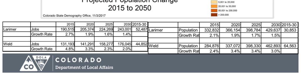
9 TRANSPORTATION FUNDING NEEDS Annual Funding Needs 2017 to 2040 o Capacity: $13,160,000 o Bridges: $ 3,500,000 o Safety: $ 500,000 o Pavement: $ 4,370,000 o Subdivisions: $ 3,640,000 o Multi-modal: $ 750,000 o Total: $25,730,000 Total ( ): $592 million 9
10 TRAFFIC GROWTH Douglas Road Traffic Increases Regional Growth Adjacent Development Example: Country Club Reserve Southwest corner of Douglas Rd & Turnberry ~ 1,500 new daily trips 55% of trips estimated to travel west on Douglas Rd 10
11 TRAFFIC GROWTH 8,000 Historic Average Daily Traffic Volumes 7,000 Average Daily Traffic (ADT) 6,000 5,000 4,000 3,000 2,000 1, Year Douglas Rd Country Club 11
12 TRAFFIC GROWTH 14,000 Historic Daily Traffic Volumes 12,000 Average Daily Traffic (ADT) 10,000 8,000 6,000 4,000 2,000 0 Year Douglas Rd Country Club 12
13 TRAFFIC GROWTH 14,000 Historic Daily Traffic Volumes 12,000 Average Daily Traffic (ADT) 10,000 8,000 6,000 4,000 2,000 0 Year Douglas Rd Country Club 13


14 TRAFFIC GROWTH ADT 14

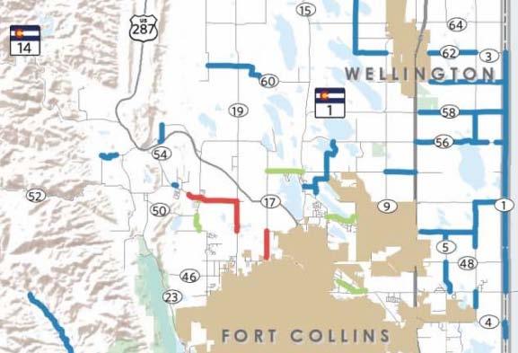
15 MAJOR ROAD NETWORK TURNBERRY DOUGLAS RD RICHARDS LAKE MTN VISTA VINE 15

16 MAJOR ROAD NETWORK Douglas Richards Lake Mountain Vista Vine 16


17 GROWTH IN NORTH FORT COLLINS Douglas Road Turnberry CR 17 17


18 GROWTH IN NORTH FORT COLLINS Douglas Road CR 17 Turnberry Extension Suniga 18

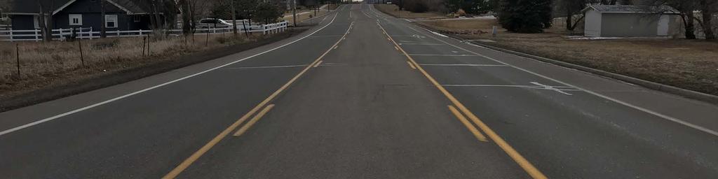
19 ROAD FUNCTION CLASSIFICATION After 2006 Prior to

20 ROAD FUNCTION Douglas Road Turnberry CR 17 Arterial Major Collector Minor Collector 20
21 TRUCK WEIGHTS Maximum legal load = 85,000 lb Colorado Legislature authorized overweight permits 97,000 lb & 110,000 lb maximums (equipment specific) CDOT started issuing permits Larimer County issuing permits for certain routes bridge considerations County did not issue permits for use of Douglas Rd. for overweight loads (>85,000 lb) in 2017 Douglas Road is not a designated truck route 21


22 PAVEMENT CONDITION Shields to SH 1 SH 1 to CR 13 CR 13 to Turnberry 22

23 PAVEMENT CONDITION Analyzed Annually 2016 Pavement Condition Index (PCI) on scale CR 54 west of SH 1 PCI = 65 CR 54 east of SH 1 PCI = 52 23

24 DOUGLAS RD SH 1 INTERSECTION
25 DOUGLAS RD SH 1 INTERSECTION Applied for and awarded a CDOT Signal Grant July 2019 Design Funding Available July 2020 Construction Funding Available Request to CDOT to move funding up a year Goal is to improve turn lanes on Douglas Rd. 25
26 TYPICAL ROAD ELEMENTS Maintain one travel lane in each direction Rural section generally with roadside drainage Widened paved shoulders to support bicyclists, etc. Turn lanes continuous or localized for both safety and capacity Neighborhood street intersections Driveways directly accessing Douglas Rd. Extend or reconstruct drainage & irrigation crossings 26
27 TYPICAL ROAD CROSS SECTIONS 27
28 RURAL ARTERIAL WITH TURN LANE 28

29 FUTURE IMPROVEMENTS SLIDE TITLE/PRESENTATION TITLE Shields Street North of Poudre River 29


30 FUTURE IMPROVEMENTS SLIDE TITLE/PRESENTATION TITLE Overland Trail South of Mulberry 30
31 RIGHT-OF-WAY (ROW) Current right-of-way varies from 60 ft to 100 ft Only acquire ROW needed for specific road improvement project Two 12 ft travel lanes 24 ft One 12 ft center turn lane 12 ft Two 8 ft paved shoulders 16 ft Two roadside drainage ditches 32 ft TOTAL 84 ft* * Dimensions may change based on terrain, embankment slopes and turn lanes 31
32 TYPICAL CROSS SECTION Boyd Lake Ave (CR 11C) 32


33 RURAL ARTERIAL NO TURN LANE Boyd Lake Ave (CR 11C) 33


34 RURAL ARTERIAL NO TURN LANE Boyd Lake Avenue (CR 11C) 34
35 RIGHT-OF-WAY (ROW) Current right-of-way varies from 60 ft to 100 ft Only acquire ROW needed for specific road improvement project Two 12 ft travel lanes 24 ft One 12 ft center turn lane 12 ft Two 8 ft paved shoulders 16 ft Two roadside drainage ditches 32 ft TOTAL 72 ft* * Dimensions may change based on terrain, embankment slopes and turn lanes 35
36 RIGHT OF WAY Right-of-Way Corridor Use of public right-of-way for roads Use by existing utilities Water distribution mains and services culverts and drainage sewer / wastewater electric natural gas cable, phone, data other underground infrastructure 36
37 37
38 38
39 PIPELINE CORRIDOR WIDTH Data Collection Process Field surveying Identify property lines & right-of-way limits Locate trees and other features Locate overhead and underground utilities Evaluate pipeline alignment, narrow corridor width 39
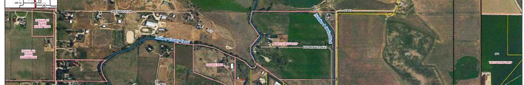
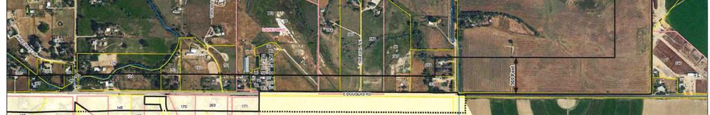
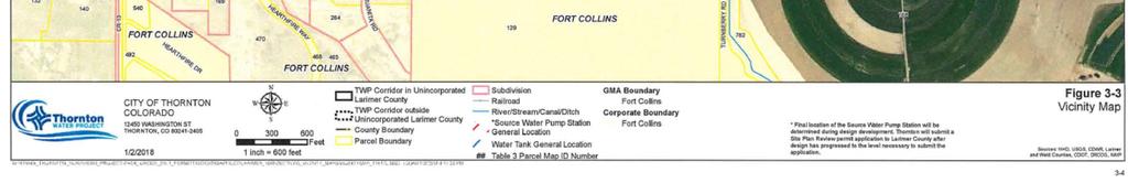
40 APPLICATION REVIEW Thornton application identified Douglas Road as a portion of the proposed corridor. Staff reviews the application and prepares a recommendation to the Planning Commission and Board of County Commissioners. Board of County Commissioners evaluates and makes a decision on the 1041 application 40
41 APPLICATION REVIEW In response to the application: Effort to narrow the 500-ft corridor along Douglas Road, with a goal to have general consistency with the potential future road right-of-way needs. Conduct field survey to collect data and evaluate pipe alignment. 41
42 PAVEMENT RESTORATION For linear utility projects, thereis a general condition to restore existing roadway pavement to a condition equivalent to pre-project conditions by the applicant. 42
43 PIPELINE 1041 PROCESS Planning Commission Hearing February 21, 6:30 PM Board of County Commissioners Hearing March 26, 6:30 PM 43
44 QUESTIONS 44
West Dimond Blvd Upgrade Jodhpur Street to Sand Lake Road
 West Dimond Blvd Jodhpur St to Sand Lake CSS Transportation Project Summary Municipality of Anchorage Project # 05 005 Project Manager: John Smith, P.E. (MOA PM&E) Project Administrator: Julie Makela,
Preliminary Engineering Study
 Preliminary Engineering Study Open House # 2 June 6, 2018 PREPARED FOR: PREPARED BY: Agenda Background and status of preliminary engineering study County Road 26 design summary County Road 63 design summary
Owl Canyon Corridor Project Overview and Summary
 Owl Canyon Corridor Project Overview and Summary December 22, 2008 The Owl Canyon corridor (generally the connection between the I-25 / Larimer County Road 70 interchange and the US 287 / Larimer County
This Chapter sets forth the minimum design, technical criteria and specifications to be used in the preparation of all roadway plans.
 4.1 GENERAL This Chapter sets forth the minimum design, technical criteria and specifications to be used in the preparation of all roadway plans. These Roadway Standards are for new construction and modification
Access requests to County streets and roadways are processed through one of the following methods:
 13.1 GENERAL APPLICATION PROCESS Access requests to County streets and roadways are processed through one of the following methods: A. Planned Developments may set general locations for access points.
GWINNETT COUNTY DEPARTMENT OF TRANSPORTATION
 GWINNETT COUNTY DEPARTMENT OF TRANSPORTATION 1 of 7 June 20, 2007 GENERAL: The following guidelines shall be used in the determination of the requirement for left turn lanes for development projects and
CHAPTER 16 PEDESTRIAN FACILITIES DESIGN AND TECHNICAL CRITERIA TABLE OF CONTENTS
 CHAPTER 16 PEDESTRIAN FACILITIES DESIGN AND TECHNICAL CRITERIA TABLE OF CONTENTS Section Title Page 16.1 General... 16-1 16.1.1 AASHTO Reference... 16-1 16.1.2 ADA Requirements... 16-1 16.2 Sidewalks...
Parks, Open Space, Trails and Recreation Master Plan
 5.3 DEFINITIONS AND VOCABULARY In order to fully understand the range of trails that have been developed, and should be developed, throughout the community, a vocabulary needs to be established for the
In Collaboration with: City of Belton Cass County FHWA Johnson County KDOT MoDOT City of Olathe City of Overland Park
 In Collaboration with: City of Belton Cass County FHWA Johnson County KDOT MoDOT City of Olathe City of Overland Park I. Background During the Johnson County Board of County Commissioner s (JCBOCC) meeting
APPENDIX L. Design Criteria
 APPENDIX L Design Criteria DRAFT PRELIMINARY DESIGN CRITERIA Page 1 of 18 APPROVALS MANAGER, ENGINEERING CITY OF HAMILTON MANAGER, ENGINEERING REGION OF HALTON DATE This Design Criteria for the New East-West
2.0 Existing Conditions
 20 2.0 Existing Conditions 2.1 Land Use, Future Growth Patterns, Physical Barriers Geographic Overview Sutter County s land use pattern is characterized by extensive agricultural areas, significant natural
US287 Asset Inventory Fort Collins. Figure 5-1 Fort Collins Bridges and Traffic Signals
 Chapter 5: City of Fort Collins US287 through Fort Collins is known as College Avenue, runs for approximately 9.25 miles, and bisects the City north to south. Within the City, US287 is a principal arterial.
Alberta Infrastructure HIGHWAY GEOMETRIC DESIGN GUIDE AUGUST 1999
 Alberta Infrastructure HIGHWAY GEOMETRIC DESIGN GUIDE AUGUST 1999,1'(; A ACCELERATION Data on acceleration from stop D-29 Effects of grade D-35 Intersections D-97, D-99 Lanes D-97, F-5, F-7, F-15, F-21,
INGHAM COUNTY ROAD DEPARTMENT AUSTIN E. CAVANAUGH ADMINISTRATION BUILDING 301 Bush Street, P.O. Box 38, Mason, MI
 INGHAM COUNTY ROAD DEPARTMENT AUSTIN E. CAVANAUGH ADMINISTRATION BUILDING 301 Bush Street, P.O. Box 38, Mason, MI 48854-0038 March 27, 2018 William M. Conklin, P.E. Managing Director FOR IMMEDIATE RELEASE:
RZC Appendix 8A Marymoor Subarea Street Requirements
 RZC Appendix 8A Marymoor Subarea Street Requirements For additional design details for Marymoor Subarea infrastructure, refer to the 2017 Marymoor Subarea Infrastructure Planning Report. STREET REQUIREMENTS
TRANSPORTATION & MOBILITY
 TRANSPORTATION & MOBILITY ROADWAY SYSTEM There are approximately 40 miles of roadways in Manitou Springs. For planning purposes, roadways are typically assigned a functional classification which defines
Roadway Classification Design Standards and Policies. Pueblo, Colorado November, 2004
 Roadway Classification Design Standards and Policies Pueblo, Colorado November, 2004 Table of Contents Page Chapter 1. General Provisions 1.1 Jurisdiction 3 1.2 Purpose and Intent 3 1.3 Modification 3
Design Criteria. Design Criteria
 F Design Criteria Design Criteria Ministry of Transportation Ministère des Transports DESIGN CRITERIA Page: 1 of 13 WORK PROJECT NO. N/A GO Bloomington Station TYPE OF PROJECT LOCATION Bloomington Road
This page intentionally left blank.
 This page intentionally left blank. COMMUNITY Coweta Community Overview Coweta Coweta, a residential community located in Wagoner County, is a suburb of Tulsa situated southeast of the metropolitan area
MASTER THOROUGHFARE PLAN
 MASTER THOROUGHFARE PLAN Master Thoroughfare Plan Update November 2015 Prepared for Town of Northlake AVO 30659 11/11/2015 1201 North Bowser Road Richardson, Texas 75081 Firm Registration No. 312 MASTER
RURAL HIGHWAY SHOULDERS THAT ACCOMMODATE BICYCLE AND PEDESTRIAN USE (TxDOT Project ) June 7, Presented by: Karen Dixon, Ph.D., P.E.
 June 7, Presented by: Karen Dixon, Ph.D., P.E.") RURAL HIGHWAY SHOULDERS THAT ACCOMMODATE BICYCLE AND PEDESTRIAN USE (TxDOT Project 0-6840) June 7, 2016 Presented by: Karen Dixon, Ph.D., P.E., TTI Team: Kay Fitzpatrick, Raul Avelar, & Subasish Das Project
RURAL HIGHWAY SHOULDERS THAT ACCOMMODATE BICYCLE AND PEDESTRIAN USE (TxDOT Project 0-6840) June 7, 2016 Presented by: Karen Dixon, Ph.D., P.E., TTI Team: Kay Fitzpatrick, Raul Avelar, & Subasish Das Project
US287 Asset Inventory Loveland. Figure 6-1 Loveland Bridges and Traffic Signals
 Chapter 6: City of Loveland US287 extends for approximately 13.1 miles through the City of Loveland. Between the northern City boundary and 29 th Street, the road is labeled Garfield Avenue, before transitioning
WYDOT DESIGN GUIDES. Guide for. Non-NHS State Highways
 WYDOT DESIGN GUIDES Guide for Non-NHS State Highways 2014 GUIDE FOR Non-NATIONAL HIGHWAY SYSTEM (Non-NHS) STATE HIGHWAYS PRESERVATION REHABILITATION RECONSTRUCTION INTRODUCTION This Guide is directed to
Application of a Complete Street
 Application of a Complete Street Southbend to Prima Vista Update May 14, 2018 Meeting Agenda Perspective and History Public input received Typical sections being considered Presentation of the 2-lane master
City of Madison, East Johnson Street North Baldwin Street to First Street Local Street Dane County
 City of Madison, East Johnson Street North Baldwin Street to First Street Local Street Dane County Public Involvement Meeting Thursday, April 28, 2016 6 to 8 P.M. Lapham Elementary School 1045 E. Dayton
Progress Report on the Design and Planning of an Infrastructure Improvement Project for the Sunnyside TIF District (Phase II)
") Presentation to the CNRC Board of Directors Regular Meeting March 11, 2015 1 Agenda Preferred Alternate Refinement for University Avenue, 3rd Street, and Beverly Avenue Intersection Improvements validate
Presentation to the CNRC Board of Directors Regular Meeting March 11, 2015 1 Agenda Preferred Alternate Refinement for University Avenue, 3rd Street, and Beverly Avenue Intersection Improvements validate
St. Francis Drive through the City of Santa Fe Corridor Study
 VII. ENGINEERING AND ENVIRONMENTAL EVALUATION TRAIL CONNECTIVITY In the southern portion of the Corridor there is a lack of a sidewalk, trail or bicycle facility within the right-ofway. However, the City
Chapter 11. Culverts and Bridges Design Checklist for Culvert Design
 Yes No N/A Design Requirements I. GENERAL DESIGN GUIDELINES Chapter 11. Culverts and Bridges A. Culvert design is in accordance with the Culverts chapter of Volume 2 of the UDFCD Manual for additional
City of Madison, East Johnson Street North Baldwin Street to First Street Local Street Dane County
 City of Madison, East Johnson Street North Baldwin Street to First Street Local Street Dane County Public Involvement Meeting Thursday, November 10, 2016 5:30 to 7 P.M. Festival Foods 810 E. Washington
Driveway Design Criteria
 Design Manual Chapter 5 - Roadway Design 5L - Access Management 5L-4 Driveway Design Criteria A. General For efficient and safe operations, access drives and minor public street intersections can be improved
CONNECTIVITY PLAN. Adopted December 5, 2017 City of Virginia Beach
 CONNECTIVITY PLAN Adopted December 5, 2017 City of Virginia Beach CONTENTS 1.0 Background & Purpose... 2 2.0 Existing Inventory & Analysis... 3 ViBe District Existing Walking Conditions... 4 3.0 ViBe District
SECTION 14: LANDSCAPING AND BEAUTIFICATION
 SECTION 14: LANDSCAPING AND BEAUTIFICATION RULE 14.1 GENERAL PROVISIONS 14.1.1 The rules and guidelines contained in this section have been established to provide proper guidelines for the beautification
SECTION 3 STREET DESIGN
 3.01 GENERAL SECTION 3 STREET DESIGN For purposes of geometric and structural design, streets shall be classified according to the following table. The City Engineer will determine the class of all proposed
TRAFFIC IMPACT STUDY CRITERIA
 Chapter 6 - TRAFFIC IMPACT STUDY CRITERIA 6.1 GENERAL PROVISIONS 6.1.1. Purpose: The purpose of this document is to outline a standard format for preparing a traffic impact study in the City of Steamboat
TABLE OF CONTENTS 7.0 THOROUGHFARE PLAN. Analysis of Future Conditions Thoroughfare Plan Proposed Cross-Sections.. 7.
 TABLE OF CONTENTS 7.0 THOROUGHFARE PLAN Analysis of Future Conditions.. 7.2 Thoroughfare Plan.. 7.3 Proposed Cross-Sections.. 7.4 Arterials Minor Arterials Collectors Local Streets Thoroughfare Plan Map
5 CIRCULATION AND STREET DESIGN
 5 CIRCULATION AND STREET DESIGN This chapter describes circulation and streetscape improvements proposed for the Northwest Chico Specific Plan Area. It includes detailed design specifications for existing
Bicycle and Pedestrian Connectivity Study. Old Colony Planning Council
 Bicycle and Pedestrian Connectivity Study Old Colony Planning Council Outline Why consider bike/peds in road designs? Why are measures needed? Connecting Land Use with Transportation Evaluation Tools:
U.S. HIGHWAY 50 IMPROVEMENT PROJECT
 U.S. HIGHWAY 50 IMPROVEMENT PROJECT in the City of South Lake Tahoe Project Purpose and Need Planned Improvements Project Cost and Delivery Schedule Proposed Construction Staging Project Partners: HIGHWAY
DRAFT - CITY OF MEDFORD TRANSPORTATION SYSTEM PLAN Roadway Cross-Sections
 Roadway Cross-Sections Medford s roadway cross-section standards apply to new and reconstructed roads. The crosssections take into consideration roadway function and operational characteristics, including
Building Great Neighbourhoods BELLEVUE AND VIRGINIA PARK
 Building Great Neighbourhoods BELLEVUE AND VIRGINIA PARK This is Meeting 2 Unfortunately, some residents in Bellevue and Virginia Park received the wrong information for this public open house (Meeting
Complete Streets. Designing Streets for Everyone. Sarnia
 Complete Streets Designing Streets for Everyone Sarnia Complete Streets ~ Sarnia ~ 2018 Introduction Our City is made up of a network of streets that we use to go for a walk, cycle to work, drive to the
Alberta Highway 881. Corridor Management Plan. Session Forum 1 - Highways. Tri-Party Transportation Conference Moving Alberta Into the Future
 Tri-Party Transportation Conference Moving Alberta Into the Future Alberta Highway 881 Corridor Management Plan Lac La Biche to Anzac Session Forum 1 - Highways March 2017 INTRODUCTION + 241 km long, 2
3.0 Future Conditions
 3.0 Future Conditions In order to be able to recommend appropriate improvements to the transportation system of the Town, it is important to first understand the nature and volume of traffic that is expected
Guidelines for Integrating Safety and Cost-Effectiveness into Resurfacing, Restoration, and Rehabilitation Projects
 Guidelines for Integrating Safety and Cost-Effectiveness into Resurfacing, Restoration, and Rehabilitation Projects NCHRP Project 15-50 July 2017 1 Research Objective Develop guidelines for safe and cost-effective
New Measure A Expenditure Categories DEFINITIONS OF ELIGIBLE EXPENDITURES Adopted March 8, 2007
 New Measure A Expenditure Categories DEFINITIONS OF ELIGIBLE EXPENDITURES Adopted March 8, 2007 City Street and County Road Maintenance Program The preservation and keeping of public street and road rights-of-way
Paul Huston, P.E., Design-Build Coordinator Chuck Gonderinger, HDR Engineering. Minnesota Department of Transportation (the Department)
") To: From: Paul Huston, P.E., Design-Build Coordinator Chuck Gonderinger, HDR Engineering Date: March 20, 2001 Subject: Roadway Geometric Design Criteria Project: TH 14/218 Design-Build Project, SP 7408-29,
To: From: Paul Huston, P.E., Design-Build Coordinator Chuck Gonderinger, HDR Engineering Date: March 20, 2001 Subject: Roadway Geometric Design Criteria Project: TH 14/218 Design-Build Project, SP 7408-29,
October 2004 REVISIONS (2) SUPERELEVATION DEVELOPMENT 11.3(2)
 SUPERELEVATION DEVELOPMENT 11.3(2)") October 2004 REVISIONS (2) Chapter 11 HORIZONTAL ALIGNMENT SUPERELEVATION DEVELOPMENT 11.3(2) Chapter 12 VERTICAL ALIGNMENT VERTICAL CURVES PASSING SIGHT DISTANCE 12.5(2) VERTICAL CURVES STOPPING SIGHT
October 2004 REVISIONS (2) Chapter 11 HORIZONTAL ALIGNMENT SUPERELEVATION DEVELOPMENT 11.3(2) Chapter 12 VERTICAL ALIGNMENT VERTICAL CURVES PASSING SIGHT DISTANCE 12.5(2) VERTICAL CURVES STOPPING SIGHT
SD Highway 50 in Yankton (4 TH Street) Reconstruction Project NH 0050(99)381 PCN By Josh Larson McLaury Engineering Inc.
 Reconstruction Project NH 0050(99)381 PCN By Josh Larson McLaury Engineering Inc.") SD Highway 50 in Yankton (4 TH Street) Reconstruction Project NH 0050(99)381 PCN 6926 By Josh Larson McLaury Engineering Inc. Project Limits SD 50 from Broadway to Burleigh and from Marne Creek to Archery
SD Highway 50 in Yankton (4 TH Street) Reconstruction Project NH 0050(99)381 PCN 6926 By Josh Larson McLaury Engineering Inc. Project Limits SD 50 from Broadway to Burleigh and from Marne Creek to Archery
SOUTHWEST SHEPHERDSVILLE SMALL AREA TRANSPORTATION STUDY
 SOUTHWEST SHEPHERDSVILLE SMALL AREA TRANSPORTATION STUDY Final Report October 2008 Prepared for: City of Shepherdsville, Kentucky Prepared by: ACKNOWLEDGEMENTS Project Steering Committee Members Sherman
Hennepin County Transportation Department
 Hennepin County Transportation Department Complete Streets Design and Implementation Prepared for the Complete Streets Task Force Craig Twinem, P.E. Design Division Manager Tom Johnson, P.E. Transportation
4.0 ACCESS CONTROL PLAN - SH 14 (JEFFERSON STREET/RIVERSIDE AVENUE)
") 4.1 Existing Conditions Roadway Physical Characteristics Typical Sections Jefferson Street 4.0 ACCESS CONTROL PLAN - SH 14 (JEFFERSON STREET/RIVERSIDE AVENUE) The existing typical cross-section for SH
4.1 Existing Conditions Roadway Physical Characteristics Typical Sections Jefferson Street 4.0 ACCESS CONTROL PLAN - SH 14 (JEFFERSON STREET/RIVERSIDE AVENUE) The existing typical cross-section for SH
City of Wayzata Comprehensive Plan 2030 Transportation Chapter: Appendix A
 A1. Functional Classification Table A-1 illustrates the Metropolitan Council s detailed criteria established for the functional classification of roadways within the Twin Cities Metropolitan Area. Table
Complete Streets Successes, Opportunities, and Challenges
 Complete Streets Successes, Opportunities, and Challenges Juliet Walker, Transportation Planner, City of Portsmouth Rob Houseman, Director of Planning and Development, Town of Wolfeboro Chris Parker, Director
5.0 Roadway System Plan
 Southwest Boise Transportation Study Page 16 5.0 Roadway System Plan The Roadway System Plan outlines roadway improvements in the Initial Study Area. It forecasts future deficiencies on the arterial system,
Houma-Thibodaux Metropolitan Planning Organization STP<200K Funding Application APPLICATION
 APPLICATION HOUMA-THIBODAUX METROPOLITAN PLANNING ORGANIZATION (HTMPO) FOR SURFACE TRANSPORTATION PROGRAM (STP
Bicycle and Pedestrian Facilities Toolbox (Excerpt from Figure 3.1)
") Appendix B Neighborhood Connections Summaries This Appendix is a supplement to the information presented in Chapter 3 Connect People. The Appendix includes a summary or profile for each of the proposed
Appendix B Neighborhood Connections Summaries This Appendix is a supplement to the information presented in Chapter 3 Connect People. The Appendix includes a summary or profile for each of the proposed
9.1 FUNCTIONAL HIGHWAY SYSTEMS IN URBANIZED AREAS Principal Arterial Interstate Principal Arterial Non-Interstate
 Greater Bozeman Area Transportation Plan (2007 Update) Chapter 9: Recommended Major Street Network & Roadway Typical Sections 9.1 FUNCTIONAL HIGHWAY SYSTEMS IN URBANIZED AREAS The discussion in this Chapter
Appendix O. Assessment of Bicycle Facility Alternatives
 Appendix O Assessment of Bicycle Facility Alternatives FINAL ASSESSMENT OF CROSS-SECTION ELEMENTS Lakeshore Road, from Mississaga Street to Dorval Drive Town of Oakville Submitted to: Town of Oakville
TRANSPORTATION COMMISSION East 19 th St, Harper to O Connell Thursday, March 29, :00 PM City Commission Room, City Hall, 6 E.
 TRANSPORTATION COMMISSION East 19 th St, Harper to O Connell Thursday, March 29, 2018 6:00 PM City Commission Room, City Hall, 6 E. 6th Street AGENDA Public comment related to the meeting topic will be
Roadway Design Manual
 Roadway Design Manual Revised December 2013 2013 by Texas Department of Transportation (512) 302-2453 all rights reserved Manual Notice 2013-1 From: Manual: Mark A. Marek, P.E Roadway Design Manual Effective
Building Great Neighbourhoods QUEEN ALEXANDRA
 Building Great Neighbourhoods QUEEN ALEXANDRA We are here today to Explain how the City is investing in improving your neighbourhood and how your neighbourhood will be improved to meet current City standards.
El Paso County 2040 Major Transportation Corridors Plan
 El Paso County 2040 Major Transportation Corridors Plan Connect-our-County Online Transportation User Survey Preliminary Results June 24, 2010 Years of Residence 2. How many years have you LIVED HERE?
10.0 CURB EXTENSIONS GUIDELINE
 10.0 CURB EXTENSIONS GUIDELINE Road Engineering Design Guidelines Version 1.0 March 2017 City of Toronto, Transportation Services City of Toronto Page 0 Background In early 2014, Transportation Services
Iowa Highway 58 Corridor Improvement Study
 1 Iowa Highway 58 Corridor Improvement Study Public Informational Meeting May 6, 2014 2 Welcome and Introductions Randy Lorenzen, City of Cedar Falls Engineer 3 Outline of Presentation Review of Project
Complete Streets Policy DAVID CRONIN, P.E., CITY ENGINEER
 Complete Streets Policy DAVID CRONIN, P.E., CITY ENGINEER Complete Streets City Commission adopted a Complete Streets policy in 2012 Complete Streets are road networks that are designed for all users:
Duwamish Way-finding and CTR Report
 V. North Tukwila When the North Tukwila Manufacturing and Industrial Center was designated in 1992 as part of the region s land use and transportation plan, the plan called for the area to set a light-rail
122 Avenue: 107 Street to Fort Road
 : 107 Street to Fort Road November 24, 2015 4:30 8:00 p.m. Meeting Purpose Summarize project work completed to date Share results of public input from Phase 1 Share the draft concept plan and proposed
Pavement Management Report. City Council Meeting of May 21, 2013
 Pavement Management Report City Council Meeting of May 21, 2013 Previous Meetings Summary In February, we presented the 2012 pavement survey and our consultant presented general pavement management strategies
PUBLIC SERVICE DEPARTMENT
 PUBLIC SERVICE DEPARTMENT Engineering Division 732 City Hall 124 West Michigan Avenue Lansing, Michigan 48933 (517) 483-4455 FAX: (517) 483-6082 http://publicservice.cityoflansingmi.com March 30, 2011
SNCC Demographic Trends
 Employment Population SNCC Demographic Trends In 1970 the SNCC population was 10,040, accounting for roughly 3% of the County population In 2015, SNCC grew to 60,567 people, roughly 11% of the County population
Physical Implications of Complete Streets Policies
 Presentation Overview Physical Implications of Complete Norm Cox, ASLA, LLA Landscape Architect Ann Arbor, Michigan, 10:45 to Noon What Are Complete Streets? What Matters to Bicyclists and Pedestrians
Multimodal Design Guidance. October 23, 2018 ITE Fall Meeting
 Multimodal Design Guidance October 23, 2018 ITE Fall Meeting Introductions Jessica Wilson TDOT Multimodal Division Office of Multimodal Planning Program Supervisor Jessica.L.Wilson@tn.gov Ali Hangul TDOT
Access Management Regulations and Standards for Minor Arterials, Collectors, Local Streets
 Access Management Regulations and Standards for Minor Arterials, Collectors, Local Streets September 2009 Paul Grasewicz Access Management Administrator Concept of Access Management The way to manage access
Southbend to Prima Vista. October 30, Floresta Corridor Master Plan
 Application of a Complete Street initiative and how it might function operationally 8 8 Southbend to Prima Vista October 30, 2017 Presentation Agenda 2 Perspective and History Traffic projections, Levels
ROAD OCCUPANCY PERMIT APPLICATION # Damascus Township, 60 Conklin Hill Road, Damascus, PA Tel Fax
 Instructions: For a driveway access permit, fill in sections 1, 2, 3 and 4, and the appropriate drawings and sign. For a Utility access, fill in sections 1, 2, 3 and 5, and figures 1 and 3. Prepare a detailed
Section Access Control Plan - SH 14 (Mulberry Street)
") US 287/SH 14 Access Management Report Section 5.0 - Access Control Plan - SH 14 (Mulberry Street) Page 92 US 287/SH 14 Access Management Report Section 5.0 - Access Control Plan - SH 14 (Mulberry Street)
US 287/SH 14 Access Management Report Section 5.0 - Access Control Plan - SH 14 (Mulberry Street) Page 92 US 287/SH 14 Access Management Report Section 5.0 - Access Control Plan - SH 14 (Mulberry Street)
NEW BRAUNFELS SEGUIN AREA REGIONAL TRANSPORTATION DRAFT PLAN NEW BRAUNFELS CITY COUNCIL MEETING
 NEW BRAUNFELS SEGUIN AREA REGIONAL TRANSPORTATION DRAFT PLAN NEW BRAUNFELS CITY COUNCIL MEETING February 13, 2012 This regional transportation plan will: 1. Review existing plans for the cities and counties,
Access Management Standards
 Access Management Standards Section 1: Application of Access Standards This chapter describes the Department's access management standards for access connections on the county roadway system. The standards
INDEX. Geometric Design Guide for Canadian Roads INDEX
 Acceleration lane, see Lanes, Acceleration Access, 8.1 Access Management and Functional Classification 8.2 Access Management by Design Classification 8.3 Access Configuration 8.4 Building Set-Back Guidelines
Technical Memorandum. Shoulder Width Standards for State Highways. Expiration. Implementation. Introduction. Purpose
 Minnesota Department of Transportation Engineering Services Division Technical Memorandum No. 17-12-TS-05 Technical Memorandum To: Electronic Distribution Recipients From: Nancy T. Daubenberger, P.E. Divison
Appendix 3 Roadway and Bike/Ped Design Standards
 Appendix 3 Roadway and Bike/Ped Design Standards OTO Transportation Plan 2040 4/20/2017 Page A3-1 Adopted Standards The adopted OTO Design Standards and Major Thoroughfare Plan are contained herein.
Final Sidewalk Feasibility Study
 Garfield Drive From Anastasia Drive to Elizabeth Place City of South Daytona July 23, 2009 Final Sidewalk Feasibility Study Prepared for: Prepared by: Final Sidewalk Feasibility Study Garfield Drive 2
Gordon Proctor Director Policy on Accommodating Bicycle and Pedestrian Travel on ODOT Owned or Maintained Facilities
 Approved: Policy: 20-004(P) Responsible Office: Planning Gordon Proctor Director Policy on Accommodating Bicycle and Pedestrian Travel on ODOT Owned or Maintained Facilities I. POLICY STATEMENT: This policy
Appendix A: Safety Assessment
 Appendix A: Safety Assessment Safety Assessment Appendix A A Statement of Philosophy The efficient and responsible investment of resources in addressing safety problems is a difficult task. Since crashes
General Design Factors
 Chapter 3: 3-1.0 Introduction General Design Factors Mn/DOT s goals include encouraging and accommodating safe bicycling. From a design perspective, these goals are achieved by first having an understanding
WYDOT DESIGN GUIDES. Guide for. NHS Arterial (Non-Interstate)
") WYDOT DESIGN GUIDES Guide for NHS Arterial (Non-Interstate) 2014 GUIDE FOR NATIONAL HIGHWAY SYSTEM (NHS) HIGHWAYS (NHS ARTERIALS, Non-Interstate) PRESERVATION REHABILITATION RECONSTRUCTION INTRODUCTION
WYDOT DESIGN GUIDES Guide for NHS Arterial (Non-Interstate) 2014 GUIDE FOR NATIONAL HIGHWAY SYSTEM (NHS) HIGHWAYS (NHS ARTERIALS, Non-Interstate) PRESERVATION REHABILITATION RECONSTRUCTION INTRODUCTION
2014 Wisconsin Tribal Transportation Conference. Matt Halada Transportation Planner NE Region
 2014 Wisconsin Tribal Transportation Conference Matt Halada Transportation Planner NE Region Implementing Wisconsin s Pedestrian and Bicycle Accommodations Law (Complete Streets) Tools and methods for
Minutes of the regular meeting of the City of Birmingham Multi-Modal Transportation Board held June 19, 2014.
 CITY OF BIRMINGHAM START-UP MEETING OF THE MULTI-MODAL TRANSPORTATION BOARD THURSDAY, JUNE 19, 2014 City Commission Room 151 Martin Street, Birmingham, Michigan Minutes of the regular meeting of the City
SUNRAY DRIVE/PERRINE RANCH ROAD FROM WEST OF DARLINGTON ROAD TO GRAND BOULEVARD AND PERRINE RANCH ROAD AT SEVEN SPRINGS BOULEVARD
 SUNRAY DRIVE/PERRINE RANCH ROAD FROM WEST OF DARLINGTON ROAD TO GRAND BOULEVARD AND PERRINE RANCH ROAD AT SEVEN SPRINGS BOULEVARD FINAL ROUTE AND POND STUDY PROJECT NO. C-9570.10 Prepared for: Pasco County
CTH M HIGHWAY PROJECT CTH Q to STH 113
 CTH M HIGHWAY PROJECT CTH Q to STH 113 PUBLIC INFORMATIONAL MEETING #3 Wednesday, May 25, 2005 Town of Westport Administration Building 5387 Mary Lake Road 6:00 p.m. to 8:00 p.m. PUBLIC INFORMATIONAL MEETING
Description of Road Management Objectives, Existing Use, and Proposed Use:
 Engineering Report White River National Forest Eagle-Holy Cross Ranger District Analysis of Road # 700 Red Sandstone Road for Motorized Mixed Use Designation Page 1 of 12 Forest: White River District:
State Highway 16/McDermott Road Kuna-Mora Road to Ada/Gem County Line
 Background State Highway 16 is the main commuter route from Gem County to the Treasure Valley. An increase in traffic and accidents on this highway have been a concern for several years, and the Idaho
Committed to Service
 Development Services Department Committed to Service January 19, 2016 TO: FROM: SUBJECT: ACHD Board of Commissioners Mindy Wallace, AICP Planner III Kirsten Subdivision/BPP15-0023 Executive Summary: The
Dr. Naveed Anwar Executive Director, AIT Consulting Affiliated Faculty, Structural Engineering Director, ACECOMS
 Dr. Naveed Anwar Executive Director, AIT Consulting Affiliated Faculty, Structural Engineering Director, ACECOMS Overview Highway Functions and Classifications Highway Design Components Design Control
Fields of St. Croix HOA Meeting. October 27, 2016
 Fields of St. Croix HOA Meeting October 27, 2016 Welcome! Why are we here? Update on Manning Avenue Phase 2 Project: Project Design Schedule Project Background Importance of Manning Avenue: Primary north-south
Overview. Illinois Bike Summit IDOT Complete Streets Policy Presentation. What is a Complete Street? And why build them? And why build them?
 Overview Illinois Bike Summit IDOT Complete Streets Policy Presentation Aren Kriks, P.E. District One Bicycle Coordinator and Bureau of Programming Project Engineer History of Complete Streets IDOT Policy
Intersection Traffic Control Feasibility Study
 Intersection Traffic Control Feasibility Study CSAH 9 at CSAH 60 (185th Avenue) Prepared For: Dakota County Transportation Department Western Service Center 14955 Galaxie Avenue, 3rd Floor Apple Valley,
LSC TRANSPORTATION CONSULTANTS, INC. 516 North Tejon Street Colorado Springs, CO (719) FAX (719)
 FAX (719)") LSC TRANSPORTATION CONSULTANTS, INC. 516 North Tejon Street Colorado Springs, CO 80903 (719) 633-2868 FAX (719) 633-5430 E-mail: lsc@lsccs.com May 15, 2009 Mr. Davis Farrar Western Slope Consulting, LLC
LSC TRANSPORTATION CONSULTANTS, INC. 516 North Tejon Street Colorado Springs, CO 80903 (719) 633-2868 FAX (719) 633-5430 E-mail: lsc@lsccs.com May 15, 2009 Mr. Davis Farrar Western Slope Consulting, LLC
FDOT Treasure Coast Traffic Impact Report April 7 through April 14, 2017
 April 7, 2017 Chuck McGinness, 954 777 4302 chuck.mcginness@dot.state.fl.us FDOT Treasure Coast Traffic Impact Report April 7 through April 14, 2017 TREASURE COAST Construction and maintenance related
Casablanca Boulevard & GO Station Access
 Casablanca Boulevard & GO Station Access Class Environmental Assessment STAKEHOLDER WORKSHOP Thursday September 27th, 2018 5:30PM 8:00PM 1 WORKSHOP PURPOSE Provide an overview of the Design Alternatives