SUNRAY DRIVE/PERRINE RANCH ROAD FROM WEST OF DARLINGTON ROAD TO GRAND BOULEVARD AND PERRINE RANCH ROAD AT SEVEN SPRINGS BOULEVARD
|
|
|
- Shanna Thomas
- 5 years ago
- Views:
Transcription

1 SUNRAY DRIVE/PERRINE RANCH ROAD FROM WEST OF DARLINGTON ROAD TO GRAND BOULEVARD AND PERRINE RANCH ROAD AT SEVEN SPRINGS BOULEVARD FINAL ROUTE AND POND STUDY PROJECT NO. C Prepared for: Pasco County Board of County Commissioners Pasco County Government Complex 7530 Little Road, Suite 320 New Port Richey, FL Prepared by: Florida Design Consultants, Inc Starkey Boulevard New Port Richey, FL April 6, 2004
2 TABLE OF CONTENTS EXECUTIVE SUMMARY... i 1.0 INTRODUCTION EXISTING CONDITIONS FUNCTIONAL CLASSIFICATION RIGHTS-OF-WAY HORIZONTAL AND VERTICAL ALIGNMENT DRAINAGE FEMA FLOOD ZONE EXISTING DRAINAGE SYSTEM SOIL CONDITIONS TRAFFIC SIGNALS UTILITIES PEDESTRIAN AND BICYCLE FACILITIES LAND USE PROJECT NEED TRAFFIC EXISTING TRAFFIC VOLUME TRAFFIC VOLUME PROJECTIONS LONG RANGE PLANNING MPO FUTURE LAND USE PASCO COUNTY TRANSPORTATION PLAN SAFETY CONSIDERATIONS ALIGNMENTS CONSIDERED TRANSPORTATION SYSTEMS MANAGEMENT OPTION DESIGN CRITERIA BUILD ALIGNMENTS CONSIDERED ON SUNRAY DRIVE/PERRINE RANCH FROM WEST OF DARLINGTON ROAD TO EAST OF GRAND BOULEVARD SUNRAY DRIVE/PERRINE RANCH ROAD - ALIGNMENT 1 (NORTH) SUNRAY DRIVE/PERRINE RANCH ROAD - ALIGNMENT 2 (SOUTH) GRAVITY WALL CONSIDERATION BUILD ALIGNMENTS CONSIDERED AT THE PERRINE RANCH ROAD AND SEVEN SPRINGS BOULEVARD INTERSECTION PERRINE RANCH ROAD AT SEVEN SPRINGS BOULEVARD - ALIGNMENT 1 (CENTERED) PERRINE RANCH ROAD AT SEVEN SPRINGS BOULEVARD ALIGNMENT 2 (SOUTH) 4.5 NO BUILD OPTION
3 5.0 ANALYSIS OF BUILD ALIGNMENTS PROPOSED DRAINAGE AND POTENTIAL POND SITE BASINS 1 AND BASIN BASIN POND EVALUATION MATRIX FLOOD PLAIN IMPACTS UTILITIES PEDESTRIAN AND BICYCLE FACILITIES ENVIRONMENTAL CONSIDERATION WETLANDS ASSESSMENT WETLAND WETLAND WETLAND WETLAND WETLAND WETLAND POTENTIAL PROJECT WETLAND IMPACTS ANALYSIS OF POTENTIAL MITIGATION SITES SURFACE WATERS LISTED SPECIES CONCLUSIONS CONTAMINATED SITES RESULTS EVALUATION MATRIX PUBLIC COMMENT RECOMMENDATIONS SUNRAY DRIVE/PERRINE RANCH ROAD PERRINE RANCH ROAD AT SEVEN SPRINGS BOULEVARD STAGED CONSTRUCTION
4 LIST OF TABLES TABLE 2-1 EXISTING VERTICAL GRADES, HORIZONTAL CURVES AND SPEEDS TABLE 3-1 EXISTING INTERSECTION OPERATION TABLE 3-2 FUTURE INTERSECTION OPERATION AND RECOMMENDED IMPROVEMENTS TABLE 3-3 CRASHES REPORTED IN THE YEARS 2000 THROUGH TABLE 4-1 DESIGN CRITERIA TABLE 4-2 GRAVITY WALL COST ANALYSIS TABLE 5-1 POND SITE DETAILS TABLE 5-2 POND EVALUATION MATRIX TABLE 5-3 WETLAND IMPACTS SUNRAY DRIVE/PERRINE RANCH ROAD WETLAND IMPACTS AND MITIGATION ALIGNMENT 1 and ALIGNMENT TABLE 5-4 POTENTIALLY OCCURRING LISTED SPECIES TABLE 5-5 PROJECT EVALUATION MATRIX LIST OF FIGURES FIGURE 1-1 PROJECT LOCATION MAP FIGURE 2-1 SUNRAY DRIVE AND GRAND BLVD. EXISTING TYPICAL SECTIONS FIGURE 2-2 PERRINE RANCH ROAD APPROACHING GRAND BLVD. TYPICAL SECTIONS FIGURE 2-3 PERRINE RANCH ROAD AT SEVEN SPRINGS BLVD. TYPICAL SECTIONS FIGURE 2-4 SUNRAY DRIVE/PERRINE RANCH ROAD FLOOD ZONES FIGURE 2-5 PERRINE RANCH ROAD AT SEVEN SPRINGS BLVD. FLOOD ZONES 2-8 FIGURE 2-6 PERRINE RANCH ROAD DRAINAGE BASINS FIGURE 2-7 SUNRAY DRIVE/PERRINE RANCH ROAD SOILS EXHIBIT FIGURE 2-8 PERRINE RANCH ROAD AT SEVEN SPRINGS BLVD. SOILS EXHIBIT 2-11 FIGURE 4-1 SUNRAY DRIVE/PERRINE RANCH ROAD AND GRAND BLVD. - PROPOSED TYPICAL SECTIONS FIGURE 4-2 SUNRAY DRIVE/PERRINE RANCH ROAD - ALIGNMENT FIGURE 4-3 SUNRAY DRIVE/PERRINE RANCH ROAD - ALIGNMENT FIGURE 4.4 PERRINE RANCH ROAD APPROACHING SEVEN SPRINGS BLVD. PROPOSAL TYPICAL SECTIONS FIGURE 4-5 SEVEN SPRINGS BLVD. APPROACHING PERRINE RANCH ROAD - PROPOSED TYPICAL SECTIONS FIGURE 4-6 PERRINE RANCH ROAD AT SEVEN SPRINGS BLVD. - ALIGNMENT FIGURE 4-7 PERRINE RANCH ROAD AT SEVEN SPRINGS BOULEVARD ALIGNMENT 2 FIGURE 5-1 PERRINE RANCH ROAD PROJECT WETLAND LOCATIONS FIGURE 5-2 PERRINE RANCH ROAD POTENTIAL MITIGATION SITES
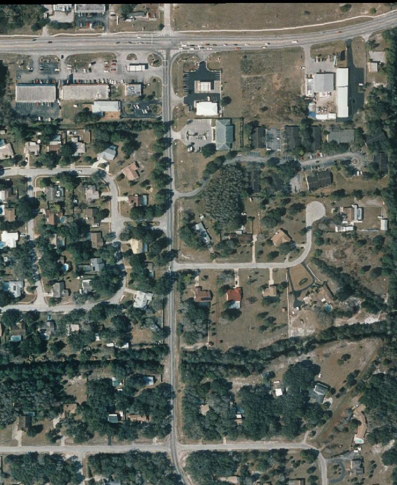
5 EXECUTIVE SUMMARY This Route and Pond Study has been completed for the Pasco County Board of County Commissioners to evaluate optional methods to improve Sunray Drive and Perrine Ranch Road from west of Darlington Road to east of Grand Boulevard and the intersection of Perrine Ranch Road and Seven Springs Boulevard. These roads are located in southwest Pasco County. Based on traffic analysis completed for this project, it was recommended that build options be considered to provide additional capacity and to improve safety. The build options are discussed below. The No Build Option is also under consideration. It will remain a viable option until a final selection has been made. SUNRAY DRIVE/PERRINE RANCH ROAD Sunray Drive and Perrine Ranch Road are two lane east west roadways that meet at a common intersection with Grand Boulevard. Left turn lanes are currently provided on Sunray Drive at Darlington Road and on Sunray Drive/Perrine Ranch Road at Grand Boulevard. Darlington Road has a two-lane roadway that is controlled with a stop sign at Sunray Drive. Grand Boulevard has a two-lane road approaching Sunray Drive/Perrine Ranch Road with the addition of a left turn lane at the signalized intersection. In order to meet the County s long-range plan to four lanes Sunray Drive/Perrine Ranch Road from U.S. 19 to Seven Springs Boulevard, a four lane divided typical section was developed for use on these eastwest roads. The proposed typical section will provide two lanes in each direction with a four foot wide paved shoulder that could be used by bicyclists. The opposing directions of travel will be separated by a 22 foot wide raised median and sidewalks will be placed on both sides of the road. Curb and gutter will be used on the inside and outside of the roadway. Underground drainage will be used and separate stormwater treatment ponds will be provided. Improvements considered for Darlington Road are to add a right turn lane headed northbound into the Sunray Drive intersection. Grand Boulevard would be improved by adding a four foot wide paved shoulder and a right turn lane along with a sidewalk for the northbound approach to Sunray Drive/Perrine Ranch Road. At the Grand Boulevard intersection, the median of Sunray Drive/Perrine Ranch Road would be reconfigured to provide a 12-foot wide left turn lane and a 10-foot wide raised median separating opposing directions of travel. Two alignment options were considered. Alignment 1 (North) would place the additional lanes on the north side of the existing roadway. This would require additional right-of-way from property located along Sunray Drive between Darlington Road and Grand Boulevard and on both sides of Perrine Ranch Road east of Grand Boulevard. Two residential relocations would result from selection of this option. Stormwater ponds would be provided on the remainder of lots to be acquired on the north side of Sunray Drive and on unused right-of-way that would result from the realignment of Perrine Ranch Road east of Grand Boulevard. Alignment 2 (South) would place the additional lanes on the south side of the road. This would require acquisition of right-of-way from property along Sunray Drive from Darlington Road to Grand Boulevard and on both sides of Perrine Ranch Road east of Grand Boulevard. Two residential and onebusiness relocations would result from this option. Two options for the treatment of stormwater runoff were developed for Alignment 2 (South). Both would use the remainder of several parcels that would be acquired as total takes from the south side of Sunray Drive.
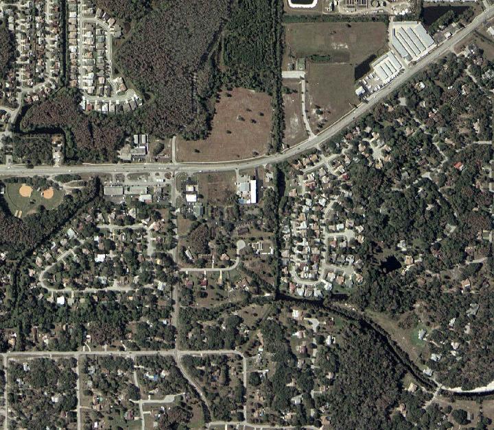
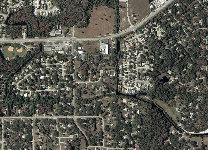
6 West of Grand Boulevard, both stormwater treatment options would use right-of-way that would remain following the relocation of Perrine Ranch Road. The second pond option would use Pond 3 plus Pond 3A, an additional parcel of property on the north side of Sunray Drive. Pond Option 2 would use Pond 3 plus Pond 3B, an additional parcel of property located on the south Side of Sunray Drive. No relocations would result from the additional parcels needed for these pond options. PERRINE RANCH ROAD AT SEVEN SPRINGS BOULEVARD Perrine Ranch Road has a two-lane pavement at Seven Springs Boulevard that has been widened to provide a right turn lane on the west approach to the intersection. County Road 77, Seven Springs Boulevard, has a four-lane roadway north and south of Perrine Ranch Road. Left and right turn lanes are provided on both approaches of Seven Springs Boulevard at the signalized Perrine Ranch Road intersection. Improvements considered for this intersection include provision for a four lane divided roadway as discussed above for Perrine Ranch Road. At the Seven Springs Boulevard intersection, the median would be reconfigured to provide a left turns lane and a 10-foot wide raised median. Seven Springs Boulevard would be widened to provide a second northbound left turn lane. This would require additional pavement to be added in the southbound direction to align the southbound through movement at the intersection. A raised median would be installed to separate opposing directions of travel and the right turn lanes would be extended in length on Seven Springs Boulevard. A four-foot wide shoulder would be provided on Perrine Ranch Road that could be used by bicyclists and sidewalks would be placed on both sides of Perrine Ranch Road and Seven Springs Boulevard within the project limits. Two alignments were prepared for Perrine Ranch Road at Seven Springs Boulevard. Some additional right-of-way would be required at the Perrine Ranch Road and Seven Springs Boulevard intersection in order to provide adequate curb returns between the intersecting roads for both alignments considered. Some temporary easements may be required along both roads to match natural ground. Two stormwater ponds will also be required for this improvement, one on each side of Seven Springs Boulevard. Alignment 1 (Centered) would center the new roadway in the existing right-of-way as much as possible, some right-of-way would be required from property located on the north side of Perrine Ranch Road between Atwell Court and Ranchside Terrace, Alignment 2 (South) would required additional right-ofway from the south side of Perrine Ranch Road. Both alignments would require corner clip right-ofway acquisition at the Perrine Ranch Road and Seven Springs Boulevard intersection. Alignment 1 would have no residential relocations and Alignment 2 (South) would have three residential relocations. Two options were developed for each required pond. West of Seven Springs Boulevard, one option would be on a single currently vacant residential lot on the north side of Perrine Ranch Road. The other would require two lots on the south side of the road that would result in two residential relocations. On the east side of Seven Springs Boulevard, options were considered on parcels located north and south of Perrine Ranch Road. Neither would require a relocation. RECOMMENDATION On Sunray Drive/Perrine Ranch Road from west of Darlington Road to east of Grand Boulevard, Alignment 2 (South) is recommended along with Ponds 3, 3A and 4. This alignment will provide a four lane divided cross section on Sunray Drive/Perrine Ranch road with the least environmental impact and cost of the build alignments considered at that intersection. At Perrine Ranch Road and Seven Springs Boulevard, Alignment 1 (Centered) with Ponds 5A and 6B are recommended. This will result in the fewest relocations and least cost of build alignments considered. ii
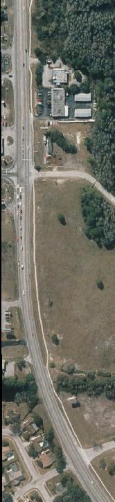
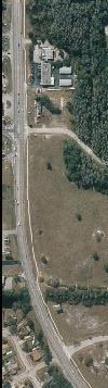
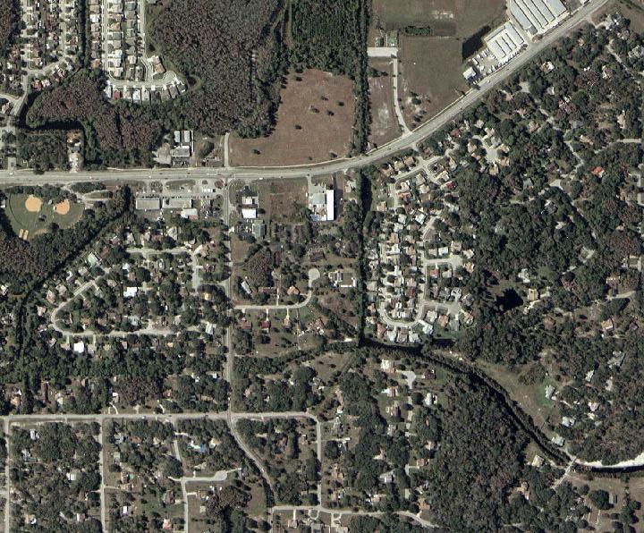
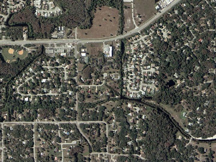
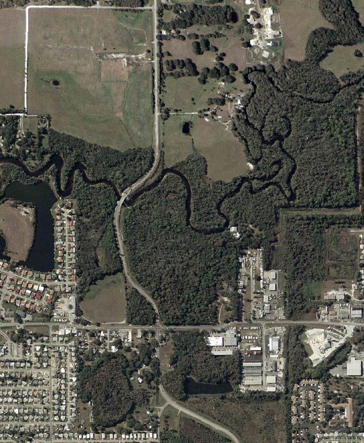
7 1.0 INTRODUCTION This Route and Pond Siting Study was prepared for the Pasco County Board of County Commissioners to determine needed improvements to segments along Sunray Drive and Perrine Ranch Road. The first location is along Sunray Drive and Perrine Ranch Road from west of Darlington Road to east of Grand Boulevard. The second is along County Road 77 (C.R. 77), Seven Springs Boulevard, north and south of Perrine Ranch Road, and along Perrine Ranch Road from west of Atwell Court to east of Seven Springs Boulevard in Pasco County, Florida. The project limits, as indicated in Figure 1-1, are located south of State Road (S.R.) 54 and east of United States Highway 19 (U.S. 19). This route study has been prepared to accommodate a future four lane improvement on Sunray Drive/Perrine Ranch Road from U.S. 19 to Seven Springs Boulevard as indicated in the Pasco County 2025 Long Range Transportation Plan. This study replaces one that was ongoing in 2003 that considered improvements that would not be compatible with the future four laning of this road. 1-1
8
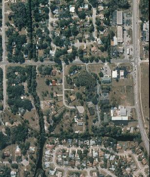
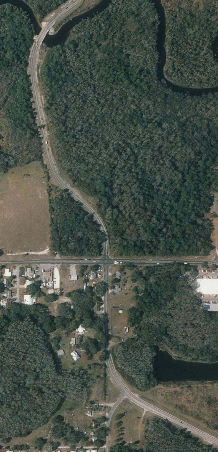
9 2.0 EXISTING CONDITIONS The following sections describe the existing conditions for the roads under review. 2.1 FUNCTIONAL CLASSIFICATION Perrine Ranch Road, Sunray Drive, Darlington Road, and Grand Boulevard are classified as collector roads and Seven Springs Boulevard is classified as an arterial in the Pasco County Comprehensive Plan for the 2003 Existing plus Committed Network Roadway Map and the 2020 Future Roadway Functional Classification Map. 2.2 RIGHTS-OF-WAY The existing right-of-way, Sunray Drive west of Darlington Road is 120 feet wide. Between Darlington Road and Grand Boulevard, Sunray Drive has a minimum right-of-way width of 70 feet. Perrine Ranch Road east of Grand Boulevard has 120 feet of right-of-way. The existing right-of-way on Grand Boulevard south of Perrine Ranch Road within the study limits is 66 feet wide. Perrine Ranch Road from Ranchside Terrace to Seven Springs Boulevard has a minimum rightof-way of 100 feet in width. East and west of that, the right-of-way has a minimum width of 70 feet. Seven Springs Boulevard has 120 feet of right-of-way north and south of Perrine Ranch Road. 2.3 HORIZONTAL AND VERTICAL ALIGNMENT Sunray Drive west of Darlington Road has a two-lane road constructed with curb and gutter. Sunray Drive between Darlington Road and Grand Boulevard has a two lane uncurbed roadway. Both Perrine Ranch Road and Grand Boulevard at their intersection have two lane rural, uncurbed pavements that have been widened at the intersection to provide exclusive left turn lanes. Perrine Ranch Road approaching the Seven Springs Boulevard intersection has a two lane rural, uncurbed pavement. The west approach to the Seven Springs Boulevard intersection has been widened to provide an exclusive right turn lane. Seven Springs Road has a four lane rural, uncurbed pavement that widens on its approaches to Perrine Ranch Road to provide an exclusive left turn lane and right turn lane for northbound and southbound traffic. See Figures 2-1 through 2-3 for typical sections within the project area. The existing maximum horizontal curve radii and vertical grades for Sunray Drive, Darlington, Perrine Ranch Road, Grand Boulevard, and Seven Springs Boulevard have been identified based upon survey information compiled for this project. These are shown in Table 2-1. The design speeds that correspond with the horizontal and vertical geometry have been identified using information from the Florida Department of Transportation s (FDOT s) Plan Preparation Manual, January 2003 and the American Association of State Highway and Transportation Officials (AASHTOs) A Policy on Geometric Design of Highways and Streets, Fourth Edition, The FDOT design criteria is based on information contained in Table of the Plans Preparation Manual and the AASHTO criteria is from Exhibit 3-41 of the cited manual. The design speeds range from a low of 20 miles per hour (MPH) for Perrine Ranch Road east of 2-1
10
11
12
13 Table 2-1. Existing Vertical Grades, Horizontal Curves and Speeds Max. Vertical Min. Horiz. Existing Posted Speed Road Limits Length Grade Radius Design Speed Limit Sunray Drive 0.25 mi W. of Darlington Rd. to 0.25 <1% 477' 35 MPH* 35 MPH Darlington Rd. Sunray Drive Darlington Rd. to Grand Blvd <1% 477' 35 MPH* 30 MPH Perrine Ranch Road Grand Blvd. to E. of Anclote 0.48 <1% 409' 35 MPH* 30 MPH River Perrine Ranch Road E of Anclote River to 0.06 mi W % Straight 40 MPH* 40 MPH of Meadowood Dr. Perrine Ranch Road 0.06 mi W of Meadowood Dr. to Seven Springs Blvd <1% 345' 30 MPH* 30 MPH Perrine Ranch Road Seven Springs Blvd. to 0.25 mi E 0.25 <1% 150' 20 MPH** 20 MPH 2-5 Darlington Road Grand Boulevard Seven Springs Blvd mi W of Sunray Dr. to Sunray Dr. Perrine Ranch Road to 0.25 mi S 0.25 mi S of Perrine Ranch Road to 0.25 mi N of Perrine Ranch Road 0.25 <1% 300' 30 MPH* 30 MPH 0.25 <1% Straight 40 MPH* 40 MPH 0.50 <1% Straight 50 MPH* 45 MPH Sources: *Florida Department of Transportation's Plans Preparation Manual, January 2003 '**American Association of State Highway and Transportation Officials, Fourth Edition, 2001 T:\61\Report\[Exist Cond.xls]Table 2-1 Date: Feb 16, 2004
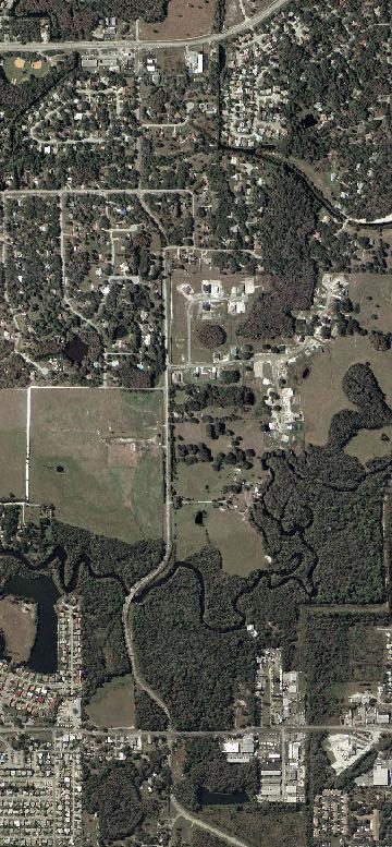
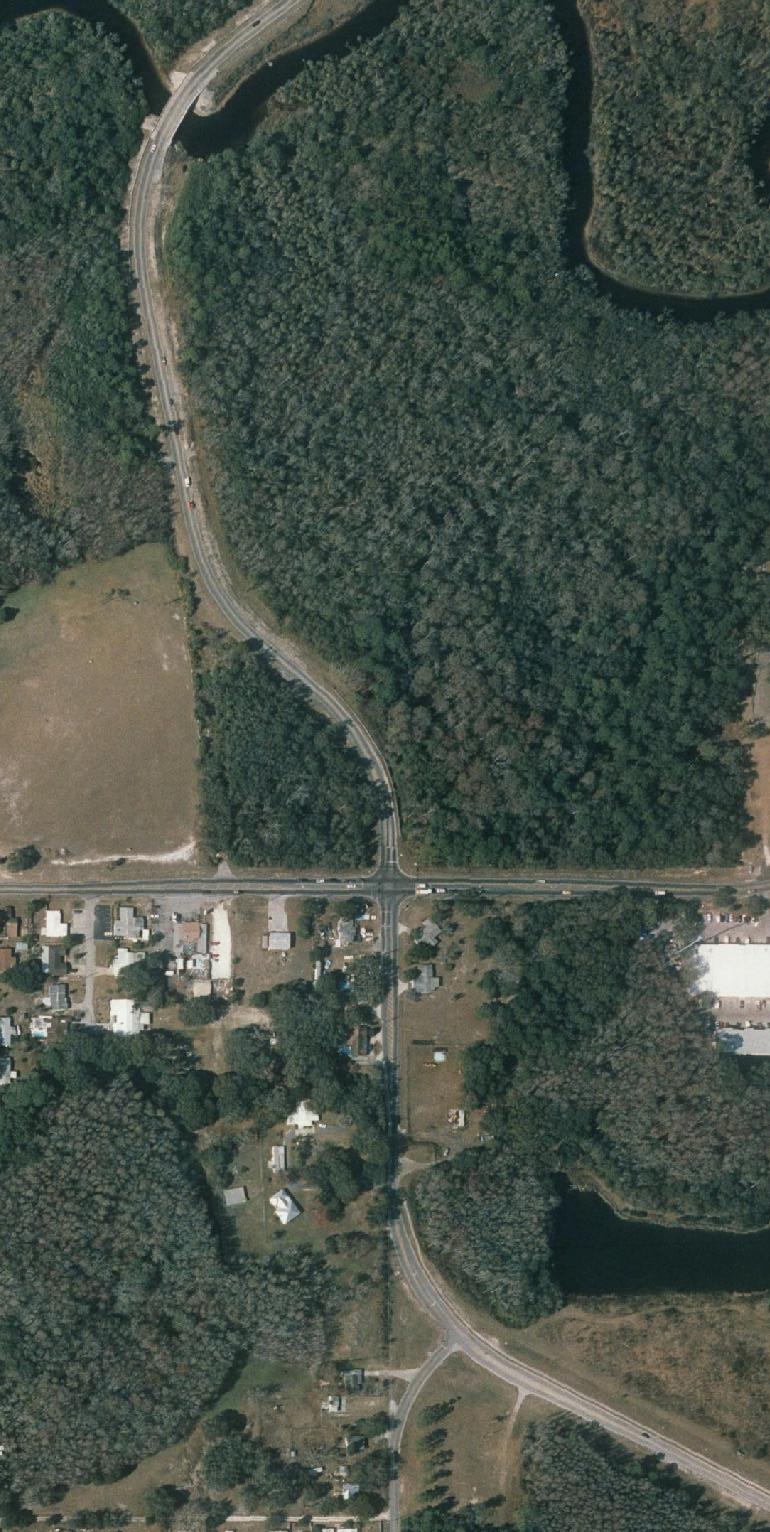
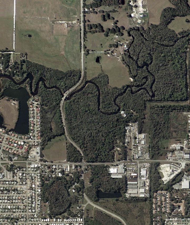
14 Seven Springs Boulevard to a maximum of 50 MPH for Seven Springs Boulevard. The posted speed limit matches or is lower than the design speed, see Table DRAINAGE FEMA FLOOD ZONE The Federal Emergency Management Administration (FEMA) flood zone maps have been reviewed for the project corridor. As indicated in Figure 2-4, the Sunray Drive/Perrine Ranch Road improvements are within both the 100-year and 500-year flood zones. As indicated in Figure 2-5, the area east of Seven Springs Boulevard is in Flood Zone A and prone to flooding. The section of Perrine Ranch Road improvements from Seven Springs Boulevard to west of Atwell Court are not within a designated flood zone EXISTING DRAINAGE SYSTEM Stormwater runoff within the project limits is conveyed through a series of shallow roadside swales discharging to other drainage ditches and canals. The ultimate discharge point is the Anclote River located on Perrine Ranch Road east of Grand Boulevard. The project has been divided into four drainage basins beginning at the west end of the project. The drainage basins are shown in Figure 2-6. Basin 1 is located at the intersection of Sunray Drive/Perrine Ranch Road and Grand Boulevard. The roadway drainage from Perrine Ranch Road within the project limits is conveyed by shallow swales and by direct overland flow to adjacent wetlands ultimately to the Gulf of Mexico. Basin 2 is located east of the intersection of Grand Boulevard and Perrine Ranch Road. The roadway drainage is conveyed through shallow swales to adjacent wetlands and to the Anclote River. Basin 3 is located from Atwell Court east to Seven Springs Boulevard. The roadway drainage within this basin is conveyed to the east, via shallow roadside swale, to a drainage ditch located approximately 350 feet west of Seven Springs Boulevard. The drainage ditch flows in a southerly direction to Duck Slough which discharges west to the Anclote River. Basin 4 is located east of Seven Springs Boulevard. The roadway drainage within this basin is conveyed overland to adjacent wetlands and into Duck Slough SOIL CONDITIONS The Soil Survey of Pasco County describes the soil types within the project limits as nearly level, poorly drained, moderately rapidly permeable sandy soil. The water table varies in depth from 12 inches to 40 inches below grade depending on the specific soil type. A map of the soil types along the project corridor is included in Figures 2-7 and
15
16
17
18
19
20 2.5 TRAFFIC SIGNALS The Perrine Ranch Road intersections with Grand Boulevard and Seven Springs Boulevard have traffic signals. These are operated and maintained by Pasco County. The signals at the intersection with Grand Boulevard are mastarm-type with one pole per corner. At Seven Springs Boulevard, strain pole signals are provided with the poles located in the southwest and northeast quadrants. 2.6 UTILITIES The following utilities are located within the project limits: Overhead electric lines are provided on the south side of Darlington Road and the south side of Sunray Drive from Darlington Road to Grand Boulevard. Overhead electric lines are provided along the east and west sides of Grand Boulevard south of Perrine Ranch Road, with lighting provided at the intersection of these two roads. Power poles, with streetlights attached, are provided on the north side of Perrine Ranch Road between Catalpa Drive/Overview Drive and Seven Springs Boulevard. East of Seven Springs Boulevard, power poles vary in location from the north side to the south side of Perrine Ranch Road. Power poles are located throughout the project limits on the west side of Seven Springs Boulevard and are located intermittently on the east side of the road. Underground gas lines owned by Clearwater Gas System are provided on Darlington Road west of Sunray Drive, Grand Boulevard south of Perrine Ranch Road, the south side of Sunray Drive/Perrine Ranch Road from Darlington Road to Seven Springs Boulevard, and on the west side of Seven Springs Boulevard through the project limits. Buried telephone cable owned by Verizon is provided on Perrine Ranch Road between Catalpa Drive/Overview Drive and the east project limit and on Seven Springs Boulevard within the project limits. The area surrounding the Grand Boulevard at Perrine Ranch Road intersection is within the Pasco County Utilities service area, however, no sewer or water services are located on either side of the roads. The area covered by the Perrine Ranch Road at Seven Springs Boulevard intersection is in the Aloha Utilities, Inc. service area for sewer and water service. A water line currently exists along the east side of Seven Springs Boulevard within the project limits. 2.7 PEDESTRIAN AND BICYCLE FACILITIES A sidewalk is provided on the north side of Sunray Drive east and west of Darlington Road. Sidewalks are currently not provided along Darlington Road within the project limits or along Grand Boulevard and Perrine Ranch Road at their intersection. Sidewalks are currently provided along the south side of Perrine Ranch Road and the east side of Seven Springs Boulevard at their intersection. No separate bicycle facilities are provided within the project limits. 2-12
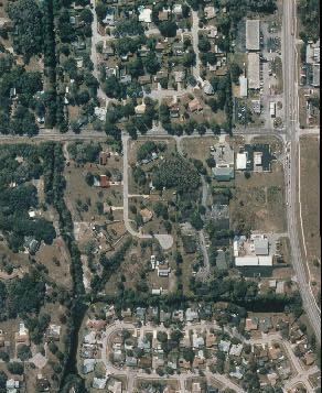
21 2.8 LAND USE The existing land use surrounding the Sunray Drive/Perrine Ranch Road segment of this project varies depending upon location. The property adjacent to Sunray Drive west of Darlington Road is currently vacant. From Darlington Road to Grand Boulevard, Sunray Drive has residential and business land uses located on both sides of the road. Grand Boulevard south of Perrine Ranch Road has residential and business uses on the west side of the road and has vacant, undeveloped property on the east side of the road. Perrine Ranch Road has vacant undeveloped property on both sides of the road east of Grand Boulevard. Much of the property located on the north side of Perrine Ranch Road east of Grand Boulevard is wetlands. The Pasco County Comprehensive Plan in its 2015 Land Use Map indicates that most of Sunray Drive west of Grand Boulevard would be Residential-9, with 9 dwelling units per gross acre (du/ga) (Res-9). The property located in the northwest, southwest, and southeast quadrants of the Sunray Drive/Perrine Ranch Road at Grand Boulevard intersection would be Retail/Office/Residential (ROR). The north side of Perrine Ranch Road east of Grand Boulevard is planned to be Industrial-Light. The north and south sides of Perrine Ranch Road east of the Grand Boulevard intersection are listed as Res-9. Perrine Ranch Road at Seven Springs Boulevard has retail and office land uses in the northwest, southwest and southeast quadrants. The northeast quadrant of the intersections is currently vacant. Perrine Ranch Road west of the Seven Springs Boulevard retail and office land uses change to residential land uses on both sides of the road. Seven Springs Boulevard south of the retail land uses that exist at the Perrine Ranch Road intersection has Oak Ridge Park on the west side of the road and residential land use on the east side. The 2015 Land Use Map identifies ROR land uses in all four quadrants of the Seven Springs Boulevard and Perrine Ranch Road intersection. This changes to Res-6, 6 du/ga, west and south of the intersection and Res-12, 12 du/ga on Seven Springs Boulevard southeast of the intersection. 2-13
22 3.0 PROJECT NEED The following sections describe the need for improvements within the project limits. 3.1 TRAFFIC The adopted models for the years 1999 and 2025 were ran and growth notes were established for the location within the study limits. At the Sunray Drive and Darlington Road intersection it was determined that a 1.15 percent per year increase would apply to existing traffic counts. For Perrine Ranch Road at Grand Boulevard a 1.12 percent annual growth rate was determined. While a 0.31 percent growth rate was determined for the Perrine Ranch Road at Seven Springs Boulevard was determined, a 1 percent growth rate was used EXISTING TRAFFIC VOLUME Existing traffic conditions were established through collection of existing turning volumes in the PM peak periods at Sunray Drive and Darlington Road and at the Perrine Ranch Road intersections with Grand Boulevard and Seven Springs Boulevard. The traffic counts were converted to peak season, peak hour turning volumes, and analyzed with the Highway Capacity Software (HCS). Traffic volumes were counted from 4:00 to 6:00 PM on January 9, 2004 on Sunray Drive and on May 1, 2002 for the Perrine Ranch Road intersections. The four consecutive highest 15-minute increment volumes were determined to be the peak hour for the count. The count peak hour was converted to peak season traffic using the FDOT peak season conversion factor for the week the count was taken. The intersections were then analyzed using the procedure recommended in the Highway Capacity Manual (HCM2000) as replicated by the HCS. The unsignalized Sunray Drive at Darlington Road intersection was found to operate at Level of Service B (LOS B). The existing signalized intersections were found to operate at LOS E and F as indicated in Table 3-1. TABLE 3-1. EXISTING INTERSECTION OPERATION Intersection PM LOS Average Delay Sunray Drive at Darlington Road B 13.6 sec/veh Perrine Ranch Road at Grand Boulevard F 83.9 sec/veh Perrine Ranch Road at Seven Springs Boulevard E 55.2 sec/veh TRAFFIC VOLUME PROJECTIONS Traffic was projected to a 2025 design year using results from runs of the Tampa Bay Region, Florida Standard Urban Transportation Model Structure (FSUTMS) program. The total traffic volumes were analyzed to determine improvements needed to achieve acceptable LOS D or better conditions. With the improvements listed in Table 3-2. It was determined that acceptable operation could be achieved at these intersections. 3-1
23 TABLE 3-2. FUTURE INTERSECTION OPERATION AND RECOMMENDED IMPROVEMENTS PM Average Recommended Improvements Intersection LOS Delay Sunray Drive at Darlington Road C 18.8 sec/veh Construct NB right turn lane and EB right turn lane. Perrine Ranch Road at Grand D 52.0 sec/veh Construct NB and WB right turn lanes. Boulevard Perrine Ranch Road at Seven Springs Boulevard D 37.9 sec/veh Construct second NB left turn lane and WB receiving lane, EB left turn lane, and WB right turn lane. 3.2 LONG RANGE PLANNING MPO The Metropolitan Planning Organization (MPO) plans for transportation improvements in Pasco County, including those related highways, public transit service, bicycle facilities. A major responsibility of the MPO is the development of a Transportation Plan that is long-range in its focus FUTURE LAND USE Future land use in the area surrounding the project was obtained from the Pasco County Comprehensive Plan. The land surrounding the project consists of a mix of uses including retail/office/residential and residential varying from 3 dwelling units per gross acre (du/ga) to 9 du/ga. Improvements being considered in this report would help improve access to these properties PASCO COUNTY TRANSPORTATION PLAN Map 2-3 of the Pasco County MPO 2025 Transportation Plan, November 2001 indicates that Sunray Drive/Perrine Ranch Road from U.S. 19 to Seven Springs Boulevard should be improved to four lanes. Map 2-8 of this plan indicates that Perrine Ranch Road is included in the Cost Affordable Plan to be extended from Seven Springs Boulevard to the east and south to Mitchell Bypass between 2007 and Copies of these maps are included in Appendix A. 3.3 SAFETY CONSIDERATIONS Available accident statistics were obtained from Pasco County. Accident statistics were obtained for calendar years 2000, 2001 and 2002 and include reported accidents on Sunray Drive from Darlington Road to Grand Boulevard and on Perrine Ranch Road between Grand Boulevard and Seven Springs Boulevard. Reported accidents totaled 94 for the 36-month period, including 31 in 2000, 25 in 2007 and 38 in Accident tabulations as provided by Pasco County are included in Appendix A and are summarized in Table 3-3. Most of the crashes occurred at the signalized intersections at Grand Boulevard (32%) and Seven Springs Boulevard (40%). These accidents consisted of a number 3-2
24 of rear end, left turn, and fixed object collisions. Adding additional turn lanes at these intersections may improve traffic flow through the intersections, thereby reducing the chance for collisions. The remaining 28% of the collisions occurred along unsignalized portions of Sunray Drive/Perrine Ranch Road. TABLE 3-3. CRASHES REPORTED IN THE YEARS 2000 THROUGH 2003 Sunray Drive/Perrine Ranch Number of Crashes Reported Road Intersection with Total Darlington Road Grand Boulevard Olde Farm Road Meadowood Drive Overview Drive/Catalpa Drive Woodbend Court Ranchside Terrace Seven Springs Boulevard Total
25 4.0 ALIGNMENTS CONSIDERED The following sections describe the options and alignments considered within the project limits. 4.1 TRANSPORTATION SYSTEMS MANAGEMENT OPTION A Transportation System Management (TSM) option has been considered for this project. TSM actions include mass transit, fringe parking and ride-sharing. These options would have little effect on reducing traffic volumes traveling on the roads in the study area. They were, therefore, dropped from further consideration. 4.2 DESIGN CRITERIA Several design criteria elements have been identified to allow development of build alignments. These are summarized in Table 4-1. The criteria has been obtained from the January 2003 version of the FDOT Plans Preparation Manual, Volume 1. An existing horizontal curve on Sunray Drive has a minimum radius of 477 feet and curves on Perrine Ranch Road between Grand Boulevard and the Anclote River have a minimum horizontal radius of 409 feet. These curves meet a 35 mph design speed using FDOT design criteria. Since the curve on Sunray Drive will exist in the future and the Anclote River bridge will not be replaced, a 35 mph design speed will be used for Sunray Drive and Perrine Ranch Road. Seven Springs Boulevard will be designed to use a 45 mph design speed. 4.3 BUILD ALIGNMENTS CONSIDERED ON SUNRAY DRIVE/PERRINE RANCH FROM WEST OF DARLINGTON ROAD TO EAST OF GRAND BOULEVARD. The proposed improvements along Sunray Drive and Perrine Ranch Road from Darlington Road to east of Grand Boulevard are to provide a four lane divided roadway. The typical section, as shown in Figure 4-1, will provide two 12 foot wide travel lanes and a 4 foot wide paved shoulder in each direction separated by a 22 foot wide raised median. Five-foot wide sidewalks would be provided for each direction of travel. Stormwater runoff would be carried by underground pipes to retention/detention ponds. Slopes as steep as 2:1 may be used to transition from the back of sidewalk elevation to natural ground, however 2:1 slopes will need to be protected for ease of maintenance and to reduce erosion potential. This roadway would require 110 feet of right-ofway. Additional right-of-way would be required for the stormwater ponds. The median would be reconfigured to provide a 12 foot wide left turn lane and a 10-foot wide median on the approaches to Grand Boulevard. A right turn lane would be added to Darlington Road approaching Sunray Drive. The south leg of Grand Boulevard would be widened on the east side to provide a four foot separation between northbound through lane and a new 12 foot wide right turn lane. A five-foot wide sidewalk would be added on the east side of the road as indicated in Figure
26
27 TABLE 4-1. DESIGN CRITERIA Darlington Road Sunray Drive, Perrine Ranch Road, and Grand Boulevard Seven Springs Boulevard Functional Classification Collector Collector Arterial Design Speed MPH 45 MPH Maximum Vertical Grade 9% 9% 7% Maximum Deflection for Through Lanes at Intersections Maximum Super elevation (E Max) Maximum Horizontal Curvature for High Speed Urban Streets 8º 6º 3º º.00' = 286'R Minimum Length of Curve 450' Desirable 400' Minimum 14º15'=400' R 525' Desirable 400' Minimum 8º15' = 694' R 675' Desirable 400' Minimum Normal Crown (Can be Back 7º00' = 5º00' = 1,146'R 2º45' = 2,083'R to Back) 819 R Roadside Slope 1:2 Max. 1:2 Max. 1:2 Max. Source: FDOT Plans Preparation Manual, January SUNRAY DRIVE/PERRINE RANCH ROAD ALIGNMENT 1 (North) As shown in Figure 4-2, Alignment 1 would require additional right-of-way from the north side of Darlington Road to west of the Anclote River. The improvements in Grand Boulevard would stay within the existing right-of-way SUNRAY DRIVE/PERRINE RANCH ROAD ALIGNMENT 2 (South) Alignment 2 along this segment of Sunray Drive/Perrine Ranch Road would require additional right-of-way from the south side of Sunray Drive from Darlington Road to Grand Boulevard and some additional right-of-way on both sides of Perrine Ranch Road east of Grand Boulevard. As with Alignment 1 no additional right-of-way would be required along Grand Boulevard, see Figure GRAVITY WALL CONSIDERATION A gravity wall is located on the north side of Perrine Ranch Road east of Grand Boulevard. Widening is under consideration for Perrine Ranch Road that will require either a new gravity wall to be constructed or to use a fill slope to account for the grade differential between the road elevation and the lower property elevation on the north side of the road. The existing ground on the north side of the road is a wetland that is also in the 100-year floodplain. 4-3
28
29
30 A comparison has been made to identify the differences between the two optional construction techniques described above. It is estimated that the gravity wall may be needed for approximately 250 feet in length. Therefore, the comparison has been made to consider placing either a gravity wall of this length or using a fill slope instead. Both options would result in some impact to wetlands and floodplains. The fill slope option would require the acquisition of ten additional feet of right-of-way to allow the fill slope to meet the existing grade. The impacts of these options are summarized in Table 4-2. As is indicated, the gravity wall option would cost approximately $189,000, while the fill slope option would cost $127,000. As with any structure, the gravity wall option would have the potential to become a problem at a later date, requiring higher maintenance or possibly replacement. Based on the higher cost and potential maintenance problems, the gravity wall option was dropped from further consideration and only the fill slope option was included in the build alternatives. 4.4 BUILD ALIGNMENTS CONSIDERED AT THE PERRINE RANCH ROAD AND SEVEN SPRINGS BOULEVARD INTERSECTION Typical sections were developed for improvements to the Perrine Ranch Road at Seven Springs Boulevard intersection. Perrine Ranch Road west of Seven Springs Boulevard was developed to provide a four lane divided roadway with a third eastbound approach lane constructed in the median. As indicated in Figure 4-4, this would allow for two lanes headed westbound, an eastbound left lane, an eastbound left-through lane, and an eastbound right turn lane. Four-foot wide shoulders would also be provided in the paved roadway. Stormwater runoff would be collected by underground pipes and transmitted to detention/retention ponds for treatment. Sixfoot wide sidewalks would be constructed back of the curb and gutter on both sides of the road. The roadway would be constructed in 100 feet of existing right-of-way. Some additional temporary construction easements may also be required to transition to natural ground. East of Seven Springs Boulevard, Perrine Ranch Road would be configured to provide a westbound combined right through land and left turn lane with an eastbound lane traveling away from the Seven Springs Boulevard intersection. A ten-foot wide median would separate opposing directions of travel and five-foot wide sidewalks would be provided on both sides of the road. The improvements would be constructed within the existing 70 feet of right-of-way, however, temporary construction easements may be required, see Figure 4-4. Seven Springs Boulevard would be widened as indicated in Figure 4-5 to provide a second northbound left turn lane approaching Perrine Ranch Road from the south. A six foot wide raised median would be placed in the roadway to separate opposing directions of travel. Sidewalks would be placed on both sides of the roadway PERRINE RANCH ROAD AT SEVEN SPRINGS BOULEVARD ALIGNMENT 1 (Centered) Alignment 1 would keep the majority of the new construction within existing rights-of-way, see Figure 4-6. Right-of-way would be needed along the roadway at the corners of Perrine Ranch Road and Seven Springs Boulevard and on the north side of the road between Atwell Court and Ranchside Terrace. Additional right-of-way would be required for stormwater retention and detention ponds and some temporary construction easements may be required. 4-6
31 Table 4-2. Gravity Wall Cost Analysis Perrine Ranch at Grand Blvd. Evaluation Factor Gravity Wall Fill Slope Wetland Impact Acres Estimated Wetland Mitigation (Acres) Floodplain Impact (Acre-feet) Threatened and Endangered Species 0 0 Right-of-way Impacts Size (Acres) Number of Parcels 0 1 Potential Relocations Residential 0 0 Business 0 0 Churches 0 0 Estimated Project Costs Road Right-of-way $ - $ 1,346 Wetland Right-of-way Costs $ 17,952 $ 35,904 Design $ 17,162 $ 3,533 Construction $ 107,265 $ 22,080 Construction Engineering Inspection $ 10,727 $ 2,208 Wetland Mitigation Site Costs $ 8,745 $ 17,490 Floodplain Impact Costs $ 27,200 $ 44,800 Total Project Costs $ 189,000 $ 127,000 Date: October 13, 2003 T:\61\Report\[Table 5 etc]t
32
33
34
35 4.4.2 PERRINE RANCH ROAD AT SEVEN SPRINGS BOULEVARD ALIGNMENT 2 (South) As an alternate to acquiring right-of-way on the north side of Perrine Ranch Road from Atwell Court to Ranchside Terrace, Alignment 2 was developed, see Figure 4-7. This option would require a shift in alignment to the south beginning at the drainage canal located west of Atwell Court to east of Ranchside Terrace. Right-of-way would be required at the four corners of the Perrine Ranch Road/Seven Springs Boulevard intersection, as well as from six parcels located on the south side of Perrine Ranch Road located between the drainage canal west of Atwell Court to east of Ranchside Terrace. 4.5 NO BUILD OPTION The No Build Option would not provide any improvements along Sunray Drive, Darlington Road, Grand Boulevard, Perrine Ranch Road, or Seven Springs Boulevard. The existing poor level of service would remain. This alternative would save the cost of construction and would not require the acquisition of any right-of-way. It would eliminate the short-term disruption that would occur during construction. Traffic congestion and increased travel times would result if this alternative is selected. It would also not reduce any of the crashes that are occurring in the area. The No Build Option will remain a viable option until a final selection is made. 4-11
36
37 5.0 ANALYSIS OF BUILD ALIGNMENTS The build alignments have been reviewed to identify drainage requirements, provide an analysis of optional pond sites, evaluate potential environmental effects, and to estimate project costs. These are covered in the following sections. 5.1 PROPOSED DRAINAGE AND POTENTIAL POND SITES The proposed drainage system will consist of a closed storm sewer system for runoff conveyance and wet detention ponds for water quality and water quantity attenuation in accordance with the Southwest Florida Water Management District (SWFWMD) criteria. A preliminary drainage analysis has been completed to define the number, location and approximate size of potential pond sites. A pre-application meeting was held with SWFWMD representatives on September 16, 2003 to obtain information on the extent of water quality treatment to be provided for stormwater runoff. A memorandum has been included in Appendix A. The Perrine Ranch corridor, at the eastern end of the project limits, consists of developed residential and commercial properties. Existing hydrologic conditions, soil type, groundwater elevation, roadway profile, and water management district criteria were taken into consideration in identifying the potential pond sites. In some locations the existing roadway profile is lower than the adjacent property. In addition, seasonal high groundwater ranges from 1 to 3 feet below existing grade throughout the corridor. These conditions relate directly to the storage volume available within the ponds. From a hydrological standpoint, the most efficient location for the ponds is to locate them at the lowest existing roadway profile points adjacent to the existing basin outfall points. The following paragraphs indicate the pond sites identified for consideration with this project BASINS 1 AND 2 Alignments 1 and 2 for Sunray Drive/Perrine Ranch Road from west of Darlington Road to east of Grand Boulevard will require additional right-of-way. For Alignment 1 west of Grand Boulevard (Basin 1), Pond Site 1 is located on the north side of Sunray Drive within the remaining portions of the parcels being impacted by this alignment. For Alignment 1 east of Grand Boulevard (Basin 2), Pond Site 2 is located within the existing right-of-way remaining after the horizontal shift for the new alignment. The discharge point for these ponds is to the adjacent wetlands. To fully utilize parcels impacted by mainline acquisition of right-of-way, no alternatives were developed to acquire other right-of-way specifically for a pond site. Basins 1 and 2 are identified in Figure 2-6. Pond Sites 1 and 2 are identified in Figure 4-2. Table 5-1 summarizes the pond site details. For Alignment 2 west of Grand Boulevard, there are two alternative pond sites developed for Pond Site 3. The remaining portion of the parcels being impacted by the mainline right-of-way acquisition are indicated as Pond 3. Pond Option 3A consists of Pond 3 and Pond 3A, an additional parcel north of Sunray Drive. Pond Option 3B consists of Pond 3 and Pond 3B, an additional vacant parcel further to the south. The discharge point for Pond Option 3A will be the wetland north of Sunray Drive. The discharge point for Pond Option 3B is a wetland south of Sunray Drive. For Alignment 2 east of Grand Boulevard, Pond Site 4, like Pond Site 2, 5-1
38 Table 5-1. Pond Site Details Alignment Pond No. Length of Roadway (ft) Drainage Area (Ac) Treatment Volume (Ac-ft) Pond Area (Ac) Sunray Dr. / Perrine Ranch Road Sunray Dr. / Perrine Ranch Road 1 2 1, Sunray Dr. / Perrine Ranch Road 2 3 with 3A Sunray Dr. / Perrine Ranch Road 2 3 with 3B Sunray Dr. / Perrine Ranch Road 2 4 1, Perrine Ranch Road at Seven Springs Blvd. 1 & 2 5A & 5B Perrine Ranch Road at Seven Springs Blvd. 1 & 2 6A & 6B Date: April 5, 2004 T:\61\Report\[Table 5 etc]t 5-5
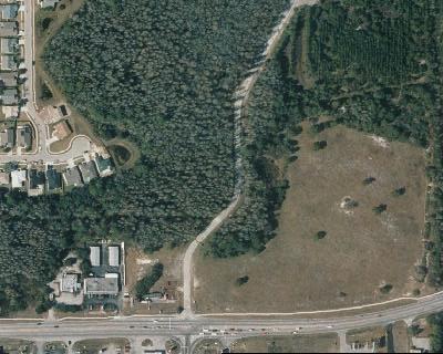
39 is located within the existing right-of-way remaining after the horizontal shift for the new alignment. Pond Sites 3, 3A, 3B and 4 are identified in Figure BASIN 3 Pond Site 5A is located on an undeveloped residential lot approximately 600 feet north of Perrine Ranch Road on Atwell Court. The north and west sides of the lot are bound by a deep drainage canal which makes for a convenient discharge point. A permanent form of groundwater control (i.e. pond liner or other barrier) may be necessary since this site is approximately 2.5 feet above the low edge of pavement on Perrine Ranch Road and the seasonal high ground water depth within the pond site is 2 to 3 feet below grade according to the NRCS Soil Survey for Pasco County. A geotechnical analysis is recommended to determine the groundwater drawdown effect of the adjacent canal prior to deciding on the use of a barrier. Pond Site 5B is located on two developed residential lots just east of Woodbend Circle on the south side of Perrine Ranch Road. The easternmost lot abuts the existing drainage ditch, which is at the approximate low point of the basin, and is the outfall point for this basin. The selection of this site would require the relocation of two residences. A pond liner or other barrier may be required to control the groundwater and maximize the pond volume. Basin 3 is identified in Figure 2-6 and Pond Sites 5A and 5B are identified in Figure 4-6. In addition to the two pond options identified above for this basin, other options were considered. One of the options considered included a vacant 1.7 acre piece of property located just north of the Shell Gas Station, which is at the northwest corner of Perrine Ranch Road and Seven Springs Boulevard. The soils on this property consist of Sellars and Smyrna Fine Sands, which have seasonal high ground water elevations from 2 feet above grade to 1 foot below grade, respectively. Effectively, there is no storage volume below existing grade. The existing grade on site is 3.5 feet above Perrine Ranch Road. An excavation of 3.5 feet on this property would potentially be filled with ground water leaving no storage volume for storm water runoff from Perrine Ranch Road. Additionally, the existing drainage ditch along the east side of the property is too shallow and flat to convey the post-developed discharge from the pond. The combination of poor soil type, high ground elevation, seasonal high ground water table, and poor outfall conveyance make this site unsuitable for use as a stormwater pond. The site was therefore dropped from further consideration. Another option considered was the use of a park site located south of Duck Slough on the west side of Seven Springs Boulevard. That site would not be a feasible location to treat stormwater runoff from this project for several reasons. The stormwater runoff would need to be piped under Duck Slough in order to not interfere with that waterway s function. The storm pipe would need to cross under Duck Slough approximately three feet below the canal bottom, making future repairs difficult. The pipe could not be placed at a higher elevation because it might obstruct flow in Duck Slough or collect debris in the waterway. In order to accomplish the above, the pond depth would need to be 15 feet or greater, which exceeds the maximum depth allowed by SWFWMD which is 12 feet. Additionally, this park is heavily used and removing a part of it for stormwater treatment purposes would not be acceptable. This option was therefore dropped from further consideration. 5-3
40 5.1.3 BASIN 4 Two (2) alternative pond sites were developed for this basin. Pond Site 6A is located on the north side of Perrine Ranch Road, east of Seven Springs Boulevard on a vacant parcel of land and adjacent to the existing wetland. The wetland is the existing point of discharge for this basin and provides a discharge point for the pond. Pond Site 6B is located on the south side of Perrine Ranch Road, east of Seven Springs Boulevard across from Pond Site 6A, on the vacant rear portion of a developed commercial property. This site is also adjacent to the wetland for convenience of discharge. Basin 4 is identified in Figure 2-6 and Pond Sites 6A and 6B are identified in Figure POND EVALUATION MATRIX A comparison of the various pond options has been made to determine the impacts and cost of each. The comparison is summarized in Table 5-2. Indicated in this table are the number of relocations required and whether they are residential, business, or churches. Also included are the number of parcels impacted and their expected cost. 5.2 FLOOD PLAIN IMPACTS There will be floodplain impacts associated with both alignments at Sunray Drive/Perrine Ranch Road. Preliminary estimates of the volumetric impacts are as follows: Alignment 1-11 Acre Feet Alignment 2 10 Acre Feet There are no flood plain impacts anticipated for Alignments 1 and 2 at Perrine Ranch Road and Seven Springs Boulevard. The SWFWMD requires that flood plain impacts be mitigated for on a one to one volumetric basis within the drainage basin in which the impacts occur. The proposed wetland mitigation sites can be used for flood plain compensation credit. If the total volume cannot be provided within these areas, then additional upland property would need to be acquired and excavated to provide the remaining compensation volume. In the land most suitable for use to compensate for floodplain impacts, it is expected that only one foot of storage can be anticipated to use to replace lost floodplain. Therefore, 2 Acre Feet of impact would require acquisition of 2 acres of property. 5.3 UTILITIES Some utility relocations will be required to allow the proposed improvements to be constructed. Since the relocations would be made at the individual utility company s expense, they have not been included in the evaluation of alternatives. 5-4
41 Table 5-2. Pond Evaluation Matrix Sunray Drive/Perrine Ranch Road Alignment Pond with 3A 3 with 3B 4 Right-of-way Impacts Number of Parcels Area (Acres) Relocations* Residential Business Church Basic Constn. Cost $ 56,000 $ 82,000 $ 43,000 $ 86,000 $ 73,000 Extra Constn. Cost $ - $ - $ - $ - $ - Right-of-way Cost* $ - $ - $ 94,400 $ 62,100 $ - Total Cost $ 56,000 $ 82,000 $ 137,400 $ 148,100 $ 73, Perrine Ranch Road at Seven Springs Boulevard Alignments 1 & 2 1 & 2 1 & 2 1 & 2 Pond 5A 5B 6A 6B Right-of-way Impacts Number of Parcels Area (Acres) Relocations Residential Business Church Basic Constn. Cost $ 45,000 $ 45,000 $ 45,000 $ 45,000 Extra Constn. Cost $ 44,000 $ - $ - $ - Right-of-way Cost $ 81,100 $ 400,000 $ 140,000 $ 140,000 Total Cost $ 170,100 $ 445,000 $ 185,000 $ 185,000 Notes: *Excludes mainline relocations and right-of-way costs No optional ponds considered for Ponds 1, 2, & 4 since they are located either within existing right-of-way or are the remainders of parcels to be acquired for roadway construction. Date: April 6, 2004 T:\61\Report\[Table 5 etc]t 5-5
42 5.4 PEDESTRIAN AND BICYCLE FACILITIES Pasco County has made a commitment to provide bicycle and pedestrian facilities within their transportation plans and programs. The bicycle and pedestrian plan has been produced to further define the steps to be taken to build an integrated system of bicycle, pedestrian, and multi-use trail facilities. The overall goal of this plan is to provide for a safe efficient, and continuous network of bicycle and pedestrian facilities. The bicycle and pedestrian plan was produced in conjunction with the 2025 Transportation Plan update, which included extensive public involvement and coordination. A minimum of a 5-foot wide sidewalk will be provided on both sides of improvements made to Sunray Drive, Perrine Ranch Road and Seven Springs Boulevard. A 5-foot wide sidewalk will also be provided on the east side of Grand Boulevard. A four foot wide paved shoulder would be provided on Sunray Drive, Perrine Ranch Road and the east side of Grand Boulevard that could be used by bicyclists. 5.5 ENVIRONMENTAL CONSIDERATIONS This section of the alternatives analysis will address the assessment of wetlands and surface waters in the project area and the potential impacts to wetlands that could result should the project alternatives be implemented. An evaluation of the potential occurrence of state and federally listed species was also conducted and the likelihood of impacts to these species and their habitats is included in this section WETLANDS ASSESSMENT Six wetland systems were identified in the project area. Two of the wetlands designated Wetlands 1 and 2 are located to the west of the intersection at Perrine Ranch Road and Grand Boulevard, in the area of the proposed four-lane improvement to Sunray Drive. Wetland 1 is located north of the existing right-of-way, and Wetland 2 is located to the south. Two wetland systems designated Wetlands 3 and 4 are located to the east of the intersection of Perrine Ranch Road and Grand Boulevard. Wetland 3 is located north of the existing right of way, and Wetland 4 is located to the south. Wetlands 5 and 6 are located east of the intersection of Perrine Ranch Road and Seven Springs Boulevard. Wetland 5 is located to the north of the Perrine Ranch Road right-of-way, and Wetland 6 is located to the south. The location of the wetland areas is shown on Figure 5-1. All of the wetlands associated with the two project areas consist of forested systems within the Anclote River watershed. The limits of the wetland areas in proximity to the project were established during field consultation with Pasco County staff from the office of the County Biologist. The limits of wetlands 3, 4, 5, and 6 were field verified by a representative from Southwest Florida Water Management District (SWFWMD) on September 11, Estimated seasonal high water levels (SHW) were also determined based on biologic indicators in each wetland and verified by SWFWMD. Pasco County Survey Dept. located the wetland limits and SHW elevations following the field reviews. The survey data that depicts the field verified limits has been obtained and will be utilized during the design phase of the project. The limits of Wetlands 1 and 2 were determined and delineated in the field with assistance from the Office of the County Biologist and was verified by SWFWMD staff. A more detailed description of the wetlands associated with the project is contained in section
43
44 5.5.2 WETLAND 1 Wetland 1 consists of a mixture of wetland habitats that extends from just west of Grand Blvd. to US 19 North. The US Fish and Wildlife Service Classification of Wetlands and Deepwater Habitats of the United States were utilized in order to provide a general description of the wetland habitat types. Wetland 1 contains areas classified as PFO3E and PSS3E. (palustrine, forested, broad leaf evergreen, seasonally flooded or saturated and palustrine, and scrub-shrub, broad leafed evergreen, seasonally flooded or saturated, respectively). The area also contains several open water bodies. Field observations indicate that large parts of the area were part of a wetland creation or restoration project associated with mitigation efforts. There is a dirt access drive from Sunray Blvd. that appears to have been constructed for the purpose of maintenance access. The regulatory status of this area should be investigated to determine if there are conservation or preservation easements in place that could restrict or limit it s use as part of the proposed project WETLAND 2 Wetland 2 lies south of Sunray Drive, southeast of the Darlington Road intersection. The area consists of cypress-dominated wetlands that have been isolated from the larger system to the north by construction of Sunray Drive. There is a culvert that extends to the north underneath Sunray Drive that provides a hydrologic connection to Wetland 1. Proposed improvements to this part of Sunray Blvd should include a provision to maintain the hydrologic connection between the two areas. Wetland 3 can be classified as PFO2E. (Palustrine, forested, needle leaf deciduous, seasonally flooded or saturated.). Dominant canopy species consist of bald cypress (Taxodium distichum), swamp bay (Magnolia virginiana), water oak (Quercus nigra), and red maple (Acer rubrum) WETLAND 3 Wetland 3 is located on the north side of Perrine Ranch road and extends from the northeast corner of Grand Boulevard and Perrine Ranch Road east to the Anclote River. Wetland 3 can be classified as PFO2E. (palustrine, forested, needle leaf deciduous, seasonally flooded or saturated.). Dominant canopy species consist of bald cypress (Taxodium distichum), swamp bay (Magnolia virginiana), water oak (Quercus nigra), and red maple (Acer rubrum). Herbaceous species consist of pickerel weed (Pontederia cordata), cinnamon fern (Osmunda cinnamomea), and various other common wetland hydrophytes. The portion of the wetland in the immediate project area is part of a much larger floodplain forest associated with the Anclote River and provides significant benefits including flood attenuation and storage, water quality treatment, and wildlife habitat WETLAND 4 Wetland 4 is located on the south side of Perrine Ranch Road approximately 700 feet east of Grand Boulevard. The wetland also extends to the east and is contiguous with the Anclote River. The portion of the wetland adjacent to the project limits contains a much higher percentage of wetland hardwood species and persistent shrub species than Wetland 3. This wetland would be classified as PFO3E and PSS3E. (palustrine, forested, broad leaf evergreen, seasonally flooded or saturated and palustrine, and scrub-shrub, broad leafed evergreen, seasonally flooded or 5-8
45 saturated, respectively). Dominant plant species consist of red maple (Acer rubrum), Carolina willow (Salix carolinina), elderberry (Sambucus canadensis), and laurel oak (Quercus laurifolia). As is the case with Wetland 3, the wetland is part of a larger system associated with the Anclote River. The wetland can be expected to provide similar flood storage and attenuation benefits as well as water quality treatment. Wildlife function and value are slightly limited as the area is severed from upstream wetland habitat by the existing roadway. Movement of aquatic based wildlife would be restricted to the bridge crossing at the main river channel WETLAND 5 Wetland 5 is located on the north side of Perrine Ranch Road approximately 300 feet east of Seven Springs Boulevard. The wetland represents a portion of the larger system that was bisected by the extension of Perrine Ranch Road east from Seven Springs Road. The wetland is classified as PFO2E (palustrine, forested needle leafed deciduous, seasonally flooded or saturated). The dominant species is bald cypress (Taxodium distichum). Sub-dominant tree species consist of laurel oak and slash pine. Field observations indicate that the wetland was impacted on the northern edge of the wetland, probably as a result of filling activities conducted on the adjacent property. This area has been identified as a potential mitigation site. The wetland is otherwise in good condition and a functional analysis would be likely to yield fairly high values for water quality, wildlife utilization and flood storage and attenuation WETLAND 6 Wetland 6 is located along the south side of Perrine Ranch Road, approximately 250 feet east of Seven Springs Blvd. The wetland area adjacent to the proposed intersection improvements is part of a much larger system that extends along the northern boundary of the Natures Hideaway subdivision. The wetland is classified as PFO2E (palustrine, forested, needle leafed deciduous, seasonally flooded or saturated). The dominant species is bald cypress (Taxodium distichum). This species almost totally dominates the tree canopy with the exception of scattered red maple (Acer rubrum). Functional values of this system would be considered relatively high and probably provided foraging habitat for wetland dependent wildlife POTENTIAL PROJECT WETLAND IMPACTS The review of the proposed alignment alternatives indicates that there are potential wetland impacts associated with each of the proposed alignments at Sunray Drive/Perrine Ranch Road. No impacts are anticipated to Wetlands 5 and 6 at Perrine Ranch Road and Seven Springs Boulevard. Alignment 1 (North) would result in impacts to Wetlands 1 and 3 due to road realignment and widening, and detention pond construction. Wetland 1 would be affected by the proposed widening of Sunray Drive. The proposed widening of Perrine Ranch Road and the construction of Pond 2 would affect Wetland 3. Alignment 2 (South) would result in impacts to Wetland 2, 3, and 4. Relatively small impacts to Wetland 2 could occur as a result of the construction of Pond 3B. The impacts to Wetland 3 would occur as a result of the realignment and widening of Perrine Ranch Road. Impacts to Wetland 4 would occur as a result of construction of Pond 4. The wetland impacts that are anticipated to occur as a result of detention pond construction could potentially be reduced or eliminated through the use of alternative construction methods. The extent of the impacts, if any, is also subject to final drainage design. Detailed analysis of measures considered during design of the project in order to avoid and minimize impacts to wetlands and surface waters will be required during review of the project by 5-9
46 SWFWMD and US Army Corps of Engineers (USACE). SWFWMD will also require analysis of the potential secondary impacts to wetland functions both during and following construction. Table 5-3 lists the estimated acreage of wetland impact that would result from each of the project alternatives. The table also lists estimated mitigation ratios and acreage for each alternative. It is important to note that wetland impacts cannot be accurately quantified absent detailed surveys and design plans. Mitigation ratios are based on the guidelines contained in the SWFWMD Basis of Review Section Mitigation ratios required by USACE are generally in the range required by SWFWMD. Permitting through USACE will require that a functional analysis utilizing The Wetland Rapid Assessment Procedure (WRAP) be performed in order to determine functional value of the impacted areas and calculate appropriate mitigation. WRAP also calculates losses to wetland function due secondary impacts. Table 5-3, Wetland Impacts Sunray Drive/Perrine Ranch Road Wetland Impacts and Mitigation [(Alignment 1 (North)] Wetland Wetland Impact Ratio Mitigation No. Type (ac) Construction (ac) Type 1 Forested :1 Road 0.42 Widening 3 Forested :1 Road 5.13 Widening Totals Wetland Impacts and Mitigation [(Alignment 2 (South)] Wetland Wetland Impact Ratio Mitigation No. Type (ac) Construction (ac) Type 2 Forested :1 Pond 3B Forested :1 Road 3.48 Widening 4 Forested :1 Pond Totals ANALYSIS OF POTENTIAL MITIGATION SITES Several sites have been identified as potential mitigation sites for the project. The need for all or a portion of the identified sites will be determined in the design phase of the project. The potential mitigation sites are identified in Figure SURFACE WATERS There are three manmade; upland cut drainage conveyances or channels within the limits of the proposed improvements to the Perrine Ranch Road/Seven Springs Boulevard intersection. A ditch located approximately 320 feet west of the intersection, on the south side of Perrine Ranch Road. Road widening for the approach to the intersection may require small impacts to this area. Since the areas are manmade, upland cut features; SWFWMD or USACE will not require 5-10
47
APPENDIX G: INTERSECTION NEEDS AT OKEECHOBEE BOULEVARD
 APPENDIX G: INTERSECTION NEEDS AT OKEECHOBEE BOULEVARD INTERSECTION NEEDS AT SR 7 and OKEECHOBEE BOULEVARD SR 7 Extension Project Development and Environment (PD&E) Study From Okeechobee Boulevard (SR
Roundabout Feasibility Memorandum
 Roundabout Feasibility Memorandum To From Gwen Pipkin Bill Howell Date June 18, 2013 Subject Roundabout Feasibility Study SR 29 PD&E Study From Oil Well Road to SR 82 Collier County, FL FPID 417540-1-22-01
PROJECT NO. 093 MA 199 H C. FEDERAL NO. xxxx WIKIEUP-WICKENBURG-PHOENIX HIGHWAY TEGNER STREET, ALTERNATIVE 10 PROJECT IMPROVEMENT
 PROJECT NO. 093 MA 199 H 5807 01C FEDERAL NO. xxxx WIKIEUP-WICKENBURG-PHOENI HIGHWAY TEGNER STREET, ALTERNATIVE 10 PROJECT IMPROVEMENT (INTERSECTION IMPROVEMENT) US 93/US 60 FINAL PROJECT ASSESSMENT April
Villages of Pasadena Hills Financial Plan UPDATED Spring 2012 DRAFT
 36 37 38 39 40 41 42 43 44 45 46 Appendix B (Unchanged from January 2009 Adoption) 47 Projects Approved Prior to VOPH Comprehensive Plan Amendment Ashley Groves Chapel Creek Chapel Hill Farmington Hills
DRAFT. Corridor study. Honeysuckle Road. October Prepared for the City of Dothan, AL. Prepared by Gresham, Smith and Partners
 DRAFT Corridor study Honeysuckle Road October 2017 Prepared for the City of Dothan, AL Prepared by TABLE OF CONTENTS SECTION I... 1 STUDY SUMMARY... 1 INTRODUCTION... 1 CONCLUSIONS... 5 SECTION II... 7
Reams Road RCA Study. Board of County Commissioners Public Hearing
 Reams Road RCA Study Board of County Commissioners Public Hearing April 24, 2018 Presentation Overview Study Overview Existing Conditions Development of Alternatives Preferred Alternative Public Involvement
Chapter 4 Traffic Analysis
 Chapter 4 Traffic Analysis PURPOSE The traffic analysis component of the K-68 Corridor Management Plan incorporates information on the existing transportation network, such as traffic volumes and intersection
Design Criteria. Design Criteria
 F Design Criteria Design Criteria Ministry of Transportation Ministère des Transports DESIGN CRITERIA Page: 1 of 13 WORK PROJECT NO. N/A GO Bloomington Station TYPE OF PROJECT LOCATION Bloomington Road
Driveway Design Criteria
 Design Manual Chapter 5 - Roadway Design 5L - Access Management 5L-4 Driveway Design Criteria A. General For efficient and safe operations, access drives and minor public street intersections can be improved
Donahue Drive Corridor Traffic Operational Evaluation
 Donahue Drive Corridor Traffic Operational Evaluation PREPARED FOR: THE CITY OF AUBURN PREPARED BY: JANUARY 2007 Donahue Drive Corridor Study--Auburn, Alabama TABLE OF CONTENTS Introduction... 1 Background
Truck Climbing Lane Traffic Justification Report
 ROUTE 7 (HARRY BYRD HIGHWAY) WESTBOUND FROM WEST MARKET STREET TO ROUTE 9 (CHARLES TOWN PIKE) Truck Climbing Lane Traffic Justification Report Project No. 6007-053-133, P 101 Ι UPC No. 58599 Prepared by:
Intersection Traffic Control Feasibility Study
 Intersection Traffic Control Feasibility Study CSAH 9 at CSAH 60 (185th Avenue) Prepared For: Dakota County Transportation Department Western Service Center 14955 Galaxie Avenue, 3rd Floor Apple Valley,
Geometric Design Tables
 Design Manual Chapter 5 - Roadway Design 5C - Geometric Design Criteria 5C-1 Geometric Design Tables A. General The following sections present two sets of design criteria tables - Preferred Roadway Elements
DESIGN MEMORANDUM WITH DESIGN EXCEPTIONS SP SP
 DRAFT NOT FINAL (Note: document was not finalized due to an eastbound stopping site distance design issue that requires more detailed bridge and roadway design considerations. This discussion starts on
SECTION 2 ALTERNATIVES INCLUDING PROPOSED ACTION 2.0 ALTERNATIVES INCLUDING PROPOSED ACTION 2.1 INTRODUCTION 2.2 ALTERNATIVES CONSIDERED BUT REJECTED
 2.0 ALTERNATIVES INCLUDING PROPOSED ACTION 2.1 INTRODUCTION The City of Starke is currently a bottleneck for traffic traveling along U.S. 301 in Bradford County. Local urban traffic combined with increasing
Highway 111 Corridor Study
 Highway 111 Corridor Study June, 2009 LINCOLN CO. HWY 111 CORRIDOR STUDY Draft Study Tea, South Dakota Prepared for City of Tea Sioux Falls Metropolitan Planning Organization Prepared by HDR Engineering,
Alberta Infrastructure HIGHWAY GEOMETRIC DESIGN GUIDE AUGUST 1999
 Alberta Infrastructure HIGHWAY GEOMETRIC DESIGN GUIDE AUGUST 1999,1'(; A ACCELERATION Data on acceleration from stop D-29 Effects of grade D-35 Intersections D-97, D-99 Lanes D-97, F-5, F-7, F-15, F-21,
SECTION 3 STREET DESIGN
 3.01 GENERAL SECTION 3 STREET DESIGN For purposes of geometric and structural design, streets shall be classified according to the following table. The City Engineer will determine the class of all proposed
Traffic Impact Analysis Chatham County Grocery Chatham County, NC
 Chatham County Grocery Chatham County, NC TABLE OF CONTENTS 1. INTRODUCTION... 1 1.1. Location and Study Area... 1 1.2. Proposed Land Use and Access... 2 1.3. Adjacent Land Uses... 2 1.4. Existing ways...
Traffic Impact Analysis Walton Acres at Riverwood Athletic Club Clayton, NC
 Traffic Impact Analysis Walton Acres at Riverwood Athletic Club Clayton, NC 1. TABLE OF CONTENTS INTRODUCTION...1 1.1. Site Location and Study Area...1 1.2. Proposed Land Use and Site Access...2 1.3.
ALLEY 24 TRAFFIC STUDY
 ALLEY 24 TRAFFIC STUDY in City of Frostburg, Maryland January 2013 3566 Teays Valley Road Hurricane, WV Office: (304) 397-5508 www.denniscorporation.com Alley 24 Traffic Study January 2013 Frostburg, Maryland
Roadway Design Manual
 Roadway Design Manual Manual Notice Archive by Texas Department of Transportation (512) 302-2453 all rights reserved Manual Notice 2009-1 From: Manual: Mark A. Marek, P.E Roadway Design Manual Effective
M-58 HIGHWAY ACCESS MANAGEMENT STUDY Mullen Road to Bel-Ray Boulevard. Prepared for CITY OF BELTON. May 2016
 M-58 HIGHWAY ACCESS MANAGEMENT STUDY Prepared for CITY OF BELTON By May 2016 Introduction Missouri State Highway 58 (M-58 Highway) is a major commercial corridor in the City of Belton. As development has
APPENDIX D COST SUMMARY TABLES
 APPENDIX D COST SUMMARY TABLES Section 1 Between Route 50 and Evergreen Mills Road 3850 linear feet of one 12 foot wide additional lane in southbound direction of Rte 606; from north side of Rte 50 to
31st Street Corridor Study Iowa Street to County Route 1057
 Iowa Street to County Route 1057 January 28, 2003 Prepared for: City of Lawrence, Kansas Douglas County, Kansas Prepared by: TranSystems Corporation 2400 Pershing Road, Suite 400 Kansas City, MO 64108
Information on display. Inside this handout. Triangle Area revisions. Project need displays. Preferred alternative on aerial maps
 Public information meeting #4 4 to 7 p.m., September 30, 2009 Hales Corners Welcome Thank you for attending this public information meeting for the WIS 100 Corridor Study. Your interest and comments are
Comments EXECUTIVE SUMMARY
 Comments 1. Under any Alternatives, MCDOT should provide better at-grade pedestrian crossing of Georgia Avenue and Forest Glen Road, including improved crosswalks with wider medians and adequate signal
City of Roseville Section 13 Design Standards. _Bikeways January 2016 SECTION 13 BIKEWAYS
 SECTION 13 BIKEWAYS 13-1 GENERAL The City of Roseville bikeway standards are designed to insure that transportation and recreational bikeways are constructed in a manner that would provide a safe and comfortable
METHODOLOGY. Signalized Intersection Average Control Delay (sec/veh)
") Chapter 5 Traffic Analysis 5.1 SUMMARY US /West 6 th Street assumes a unique role in the Lawrence Douglas County transportation system. This principal arterial street currently conveys commuter traffic
Chapter 5 Traffic Analysis 5.1 SUMMARY US /West 6 th Street assumes a unique role in the Lawrence Douglas County transportation system. This principal arterial street currently conveys commuter traffic
FINAL DESIGN TRAFFIC TECHNICAL MEMORANDUM
 FINAL DESIGN TRAFFIC TECHNICAL MEMORANDUM July 2014 FINAL (SR 43) Project Development and Environment Study From State Road 60 (Adamo Drive) to I-4 (SR 400) Hillsborough County, Florida Work Program Item
This Chapter sets forth the minimum design, technical criteria and specifications to be used in the preparation of all roadway plans.
 4.1 GENERAL This Chapter sets forth the minimum design, technical criteria and specifications to be used in the preparation of all roadway plans. These Roadway Standards are for new construction and modification
Public Information Meeting. Orange Camp Road. Dr. Martin Luther King Jr. Beltway to I-4. Presented by: Volusia County August 2, 2018
 Public Information Meeting Orange Camp Road Dr. Martin Luther King Jr. Beltway to I-4 Presented by: Volusia County August 2, 2018 1 Project Goals To improve the operations and safety for Orange Camp Road
WYDOT DESIGN GUIDES. Guide for. Non-NHS State Highways
 WYDOT DESIGN GUIDES Guide for Non-NHS State Highways 2014 GUIDE FOR Non-NATIONAL HIGHWAY SYSTEM (Non-NHS) STATE HIGHWAYS PRESERVATION REHABILITATION RECONSTRUCTION INTRODUCTION This Guide is directed to
JONESBORO HIGHWAY 63 HIGHWAY 18 CONNECTOR STUDY
 JONESBORO HIGHWAY 63 HIGHWAY 18 CONNECTOR STUDY Craighead County May 2007 JONESBORO HIGHWAY 63 HIGHWAY 18 CONNECTOR STUDY Craighead County May 2007 Prepared by Planning and Research Division Arkansas State
Transportation Impact Study for Abington Terrace
 Transportation Impact Study for Abington Terrace Abington Township, Montgomery County, PA Sandy A. Koza, P.E., PTOE PA PE License Number PE059911 Prepared by McMahon Associates, Inc. 425 Commerce Drive,
Glenn Avenue Corridor Traffic Operational Evaluation
 Glenn Avenue Corridor Traffic Operational Evaluation PREPARED FOR: THE CITY OF AUBURN PREPARED BY: DECEMBER 2007 Glenn Avenue Corridor Study--Auburn, Alabama TABLE OF CONTENTS Introduction... 1 Background
TRAFFIC IMPACT ANALYSIS
 TRAFFIC IMPACT ANALYSIS FOR THE CHAMPAIGN UNIT#4 SCHOOL DISTRICT PROPOSED HIGH SCHOOL (SPALDING PARK SITE) IN THE CITY OF CHAMPAIGN Final Report Champaign Urbana Urbanized Area Transportation Study 6/24/2014
WYDOT DESIGN GUIDES. Guide for. NHS Arterial (Non-Interstate)
") WYDOT DESIGN GUIDES Guide for NHS Arterial (Non-Interstate) 2014 GUIDE FOR NATIONAL HIGHWAY SYSTEM (NHS) HIGHWAYS (NHS ARTERIALS, Non-Interstate) PRESERVATION REHABILITATION RECONSTRUCTION INTRODUCTION
WYDOT DESIGN GUIDES Guide for NHS Arterial (Non-Interstate) 2014 GUIDE FOR NATIONAL HIGHWAY SYSTEM (NHS) HIGHWAYS (NHS ARTERIALS, Non-Interstate) PRESERVATION REHABILITATION RECONSTRUCTION INTRODUCTION
State Road 54/56 Tampa Bay s Northern Loop. The Managed Lane Solution Linking I-75 to the Suncoast Parkway
 State Road 54/56 Tampa Bay s Northern Loop The Managed Lane Solution Linking I-75 to the Suncoast Parkway SUNCOAST PARKWAY Both I 75 and the Suncoast Parkway are planning, or in the process of constructing,
Access Management Standards
 Access Management Standards Section 1: Application of Access Standards This chapter describes the Department's access management standards for access connections on the county roadway system. The standards
Access requests to County streets and roadways are processed through one of the following methods:
 13.1 GENERAL APPLICATION PROCESS Access requests to County streets and roadways are processed through one of the following methods: A. Planned Developments may set general locations for access points.
Recommended Roadway Plan Section 2 - Land Development and Roadway Access
 Recommended Roadway Plan Section 2 - Land Development and Roadway Access SECTION 2 Land Development and Roadway Access 2.1 Land Use and Access Management The Federal Highway Administration (FHWA) defines
MEETING FACILITY 2901 GIBFORD DRIVE CITY OF OTTAWA TRANSPORTATION BRIEF. Prepared for: Holiday Inn Express 2881 Gibford Drive Ottawa, ON K1V 2L9
 MEETING FACILITY 2901 GIBFORD DRIVE CITY OF OTTAWA TRANSPORTATION BRIEF Prepared for: Holiday Inn Express 2881 Gibford Drive Ottawa, ON K1V 2L9 December 18, 2012 112-566 Brief_1.doc D. J. Halpenny & Associates
TRANSPORTATION ANALYSIS REPORT US Route 6 Huron, Erie County, Ohio
 TRANSPORTATION ANALYSIS REPORT US Route 6 Huron, Erie County, Ohio December 12, 2012 Prepared for: The City of Huron 417 Main Huron, OH 44839 Providing Practical Experience Technical Excellence and Client
Highway 49, Highway 351 and Highway 91 Improvements Feasibility Study Craighead County
 Highway 49, Highway 351 and Highway 91 Improvements Feasibility Study Craighead County Executive Summary March 2015 Highway 49, Highway 351 and Highway 91 Improvements Feasibility Study Craighead County
Clearlake Road (State Road 501) Project Development & Environment (PD&E) Study
 Project Development & Environment (PD&E) Study") Clearlake Road (State Road 501) Project Development & Environment (PD&E) Study FROM MICHIGAN AVENUE TO INDUSTRY ROAD BREVARD COUNTY, FLORIDA Financial Project ID No: 433605-1-22-01 Federal Aid Project
Clearlake Road (State Road 501) Project Development & Environment (PD&E) Study FROM MICHIGAN AVENUE TO INDUSTRY ROAD BREVARD COUNTY, FLORIDA Financial Project ID No: 433605-1-22-01 Federal Aid Project
Readington Road (C.R. 637) Construction
 Construction") Public Information Meeting Thursday, August 2, 2012 Readington Road (C.R. 637) Construction from Dreahook Road to Harlan School Road Branchburg Township, Somerset County Readington Township, Hunterdon
Public Information Meeting Thursday, August 2, 2012 Readington Road (C.R. 637) Construction from Dreahook Road to Harlan School Road Branchburg Township, Somerset County Readington Township, Hunterdon
INDUSTRIAL BUILDING 3009 HAWTHORNE ROAD CITY OF OTTAWA TRANSPORTATION OVERVIEW REVISED. Prepared for: Canada Inc.
 INDUSTRIAL BUILDING 3009 HAWTHORNE ROAD CITY OF OTTAWA TRANSPORTATION OVERVIEW REVISED Prepared for: 7849648 Canada Inc. Octiober 1, 2015 114-598 Overview_2.doc D. J. Halpenny & Associates Ltd. Consulting
Paul Huston, P.E., Design-Build Coordinator Chuck Gonderinger, HDR Engineering. Minnesota Department of Transportation (the Department)
") To: From: Paul Huston, P.E., Design-Build Coordinator Chuck Gonderinger, HDR Engineering Date: March 20, 2001 Subject: Roadway Geometric Design Criteria Project: TH 14/218 Design-Build Project, SP 7408-29,
To: From: Paul Huston, P.E., Design-Build Coordinator Chuck Gonderinger, HDR Engineering Date: March 20, 2001 Subject: Roadway Geometric Design Criteria Project: TH 14/218 Design-Build Project, SP 7408-29,
FRONT RANGE CROSSINGS TRAFFIC IMPACT STUDY
 FRONT RANGE CROSSINGS TRAFFIC IMPACT STUDY Prepared for: City of Thornton And Colorado Department of Transportation Prepared by: 11 Blake Street, Suite 2 Denver, Colorado 822 Contact: Brian Bern, PE, PTOE
General Design Factors
 Chapter 3: 3-1.0 Introduction General Design Factors Mn/DOT s goals include encouraging and accommodating safe bicycling. From a design perspective, these goals are achieved by first having an understanding
DUNBOW ROAD FUNCTIONAL PLANNING
 DUNBOW ROAD FUNCTIONAL PLANNING Final Report August 3, 216 #31, 316 5th Avenue NE Calgary, AB T2A 6K4 Phone: 43.273.91 Fax: 43.273.344 wattconsultinggroup.com Dunbow Road Functional Planning Final Report
Evaluation of M-99 (Broad Street) Road Diet and Intersection Operational Investigation
 Road Diet and Intersection Operational Investigation") Evaluation of M-99 (Broad Street) Road Diet and Intersection Operational Investigation City of Hillsdale, Hillsdale County, Michigan June 16, 2016 Final Report Prepared for City of Hillsdale 97 North Broad
Evaluation of M-99 (Broad Street) Road Diet and Intersection Operational Investigation City of Hillsdale, Hillsdale County, Michigan June 16, 2016 Final Report Prepared for City of Hillsdale 97 North Broad
RURAL HIGHWAY SHOULDERS THAT ACCOMMODATE BICYCLE AND PEDESTRIAN USE (TxDOT Project ) June 7, Presented by: Karen Dixon, Ph.D., P.E.
 June 7, Presented by: Karen Dixon, Ph.D., P.E.") RURAL HIGHWAY SHOULDERS THAT ACCOMMODATE BICYCLE AND PEDESTRIAN USE (TxDOT Project 0-6840) June 7, 2016 Presented by: Karen Dixon, Ph.D., P.E., TTI Team: Kay Fitzpatrick, Raul Avelar, & Subasish Das Project
RURAL HIGHWAY SHOULDERS THAT ACCOMMODATE BICYCLE AND PEDESTRIAN USE (TxDOT Project 0-6840) June 7, 2016 Presented by: Karen Dixon, Ph.D., P.E., TTI Team: Kay Fitzpatrick, Raul Avelar, & Subasish Das Project
INTRODUCTION THOROUGHFARE SYSTEM CLASSIFICATIONS
 INTRODUCTION The thoroughfare plan will assist public officials in the development of a specialized system for efficient and safe movement of vehicular traffic while minimizing potential conflicts with
5.0 Roadway System Plan
 Southwest Boise Transportation Study Page 16 5.0 Roadway System Plan The Roadway System Plan outlines roadway improvements in the Initial Study Area. It forecasts future deficiencies on the arterial system,
CHAPTER 16 PEDESTRIAN FACILITIES DESIGN AND TECHNICAL CRITERIA TABLE OF CONTENTS
 CHAPTER 16 PEDESTRIAN FACILITIES DESIGN AND TECHNICAL CRITERIA TABLE OF CONTENTS Section Title Page 16.1 General... 16-1 16.1.1 AASHTO Reference... 16-1 16.1.2 ADA Requirements... 16-1 16.2 Sidewalks...
3.0 PROJECT DESCRIPTION
 The following section of the Draft EIR contains a description of the proposed Elk Grove Boulevard/SR 99 Interchange Modification project, consistent with the requirements of CEQA Guidelines Section 15124.
Traffic Impact Study WestBranch Residential Development Davidson, NC March 2016
 Traffic Impact Study WestBranch Residential Development Davidson, NC March 216 TRAFFIC IMPACT STUDY FOR THE WestBranch Residential Development LOCATED IN DAVIDSON, NC Prepared For: Lennar Carolinas, LLC
ROUTE 22 CORRIDOR STUDY: CORRIDOR MANAGEMENT PLAN APPENDIX A A-12
 ROUTE 22 CORRIDOR STUDY: CORRIDOR MANAGEMENT PLAN APPENDIX A A-12 3.0 HARLEM VALLEY TRANSPORTATION PLAN Incorporates transportation systems management and safety improvements. Location: Route 22 corridor
Waterford Lakes Small Area Study
 Waterford Lakes Small Area Study Existing Traffic Conditions PREPARED FOR: ORANGE COUNTY PUBLIC WORKS DEPARTMENT TRAFFIC ENGINEERING DIVISION ORLANDO, FLORIDA PREPARED WITH: INWOOD CONSULTING ENGINEERS
Traffic Impact Statement
 Traffic Impact Statement Mixed Use Development, US 41 and Old Trail Drive aka Tide-Starbucks 4900 9 th Street North General Development Site Plan (GDSP) Collier County, FL 10/6/2015 Prepared for: Prepared
URBAN QUARRY HEADQUARTERS 2717 STEVENAGE DRIVE CITY OF OTTAWA TRANSPORTATION OVERVIEW. Prepared for: Urban Quarry 4123 Belgreen Drive, Ottawa K1G 3N2
 URBAN QUARRY HEADQUARTERS 2717 STEVENAGE DRIVE CITY OF OTTAWA TRANSPORTATION OVERVIEW Prepared for: Urban Quarry 4123 Belgreen Drive, Ottawa K1G 3N2 February 27, 2014 113-584 Overview_1.doc D. J. Halpenny
Figure 1: Vicinity Map of the Study Area
 ARIZONA TEXAS NEW MEXICO OKLAHOMA May 5, 2016 Mr. Anthony Beach, P.E. BSP Engineers 4800 Lakewood Drive, Suite 4 Waco, Texas 76710 Re: Intersection and Access Analysis along Business 190 in Copperas Cove
State Street and Pierce Park Lane Intersection Concept Report
 State Street and Pierce Park Lane Intersection Prepared for September 2017 Prepared by CITATION Parametrix. 2017. State Street & Pierce Park Lane Intersection. Prepared by Parametrix, Boise, ID. September
Intersection Improvement Study Hendricks County Road 100 South & Dan Jones Road Avon, Indiana
 Intersection Improvement Study Hendricks Avon, Indiana Final Report November 7, 2003 Prepared for The Town of Avon By DLZ Indiana, LLC 36 South Pennsylvania Street, Suite 360 Indianapolis, Indiana 46204
Cheyenne Metropolitan Planning Organization
 Dell Range Boulevard Corridor Study PHASE II SECTION 20 DRAFT Prepared for: Cheyenne Metropolitan Planning Organization November 20, 2015 (Section 20 is bordered by Powderhouse Road on the west, Storey
October 2004 REVISIONS (2) SUPERELEVATION DEVELOPMENT 11.3(2)
 SUPERELEVATION DEVELOPMENT 11.3(2)") October 2004 REVISIONS (2) Chapter 11 HORIZONTAL ALIGNMENT SUPERELEVATION DEVELOPMENT 11.3(2) Chapter 12 VERTICAL ALIGNMENT VERTICAL CURVES PASSING SIGHT DISTANCE 12.5(2) VERTICAL CURVES STOPPING SIGHT
October 2004 REVISIONS (2) Chapter 11 HORIZONTAL ALIGNMENT SUPERELEVATION DEVELOPMENT 11.3(2) Chapter 12 VERTICAL ALIGNMENT VERTICAL CURVES PASSING SIGHT DISTANCE 12.5(2) VERTICAL CURVES STOPPING SIGHT
APPENDIX L: COST ESTIMATING TOOLS
 APPENDIX L: COST ESTIMATING TOOLS Rural Arterial From LRE MOT * Mobilization * Subtotal Scope Contingency (25%) Total PE Design (15%) CEI (15%) Total Project ** New (2-Lane Roadway) with 5' Paved Shoulders
City of Wayzata Comprehensive Plan 2030 Transportation Chapter: Appendix A
 A1. Functional Classification Table A-1 illustrates the Metropolitan Council s detailed criteria established for the functional classification of roadways within the Twin Cities Metropolitan Area. Table
City of Madison, East Johnson Street North Baldwin Street to First Street Local Street Dane County
 City of Madison, East Johnson Street North Baldwin Street to First Street Local Street Dane County Public Involvement Meeting Thursday, April 28, 2016 6 to 8 P.M. Lapham Elementary School 1045 E. Dayton
INDUSTRIAL BUILDING 1660 COMSTOCK ROAD CITY OF OTTAWA TRANSPORTATION OVERVIEW. Prepared for:
 INDUSTRIAL BUILDING 1660 COMSTOCK ROAD CITY OF OTTAWA TRANSPORTATION OVERVIEW Prepared for: Simluc Contractors Limited 2550 Blackwell Street, Ottawa K1B 5R1 October 18, 2013 113-584 Overview_1.doc D. J.
Proposed Action, Purpose and Need Technical Memorandum
 Proposed Action, Purpose and Need Technical Memorandum MoPac (State Loop 1) Intersections, Austin District From North of Slaughter Lane to South of La Crosse Avenue CSJ: 3136-01-015 Travis County, Texas
4. ENVIRONMENTAL IMPACT ANALYSIS 9. TRANSPORTATION AND TRAFFIC
 4. ENVIRONMENTAL IMPACT ANALYSIS 9. TRANSPORTATION AND TRAFFIC 4.9.1 INTRODUCTION The following section addresses the Proposed Project s impact on transportation and traffic based on the Traffic Study
REDEVELOPMENT TRAFFIC IMPACT STUDY
 REDEVELOPMENT TRAFFIC IMPACT STUDY For Wendy s Parker, Colorado January 215 Prepared for: Sterling Design Associates, LLC 29 W. Littleton Boulevard #3 Littleton, Colorado 812 Prepared by: 1233 Airport
WELCOME PTH 59N - PTH 101 INTERCHANGE FUNCTIONAL DESIGN STUDY PUBLIC INFORMATION SESSION MONDAY, JUNE 13, :00 P.M. - 8:00 P.M.
 WELCOME - PTH 1 INTERCHANGE FUNCTIONAL DESIGN STUDY PUBLIC INFORMATION SESSION MONDAY, JUNE 13, 11 4:00 P.M. - 8:00 P.M. PROJECT STUDY AREA 1 Wenzel Street PR 2 Pritchard Farm Farm Road Road McGregor Farm
GEOMETRIC DESIGN STANDARDS FOR NEW RESIDENTIAL SUBDIVISION STREETS TABLE 1A CG-6 CURB AND GUTTER SECTION
 TABLE 1A CG-6 CURB AND GUTTER SECTION HORIZONTAL AND VERTICAL CONTROLS CURB AND GUTTER ROADWAYS MAXIMUM 3:1 CUT OR FILL SLOPE CURVE DATA MIN. SIGHT DISTANCE PROJECTED TRAFFIC VOLUME (ADT) MIN. DESIGN SPEED
Queensgate Drive Corridor Traffic Study
 January 2015 Prepared for: City of Richland Prepared by: J-U-B ENGINEERS, Inc. 2810 W. Clearwater Avenue, Suite 201 Kennewick, Washington 99336 Table of Contents Introduction and Background... 1 Existing
Route 7 Corridor Study
 Route 7 Corridor Study Executive Summary Study Area The following report analyzes a segment of the Virginia State Route 7 corridor. The corridor study area, spanning over 5 miles in length, is a multi
Roadway Design Manual
 Roadway Design Manual Revised December 2013 2013 by Texas Department of Transportation (512) 302-2453 all rights reserved Manual Notice 2013-1 From: Manual: Mark A. Marek, P.E Roadway Design Manual Effective
ENGINEERING STANDARD FOR GEOMETRIC DESIGN OF ROADS AND STREETS ORIGINAL EDITION MAR. 1996
 ENGINEERING STANDARD FOR GEOMETRIC DESIGN OF ROADS AND STREETS ORIGINAL EDITION MAR. 1996 This standard specification is reviewed and updated by the relevant technical committee on Dec. 2000(1) and July.
City of Hanover TRANSPORTATION STUDY
 City of Hanover TRANSPORTATION STUDY AUGUST 2006 Prepared by: WSB & Associates, Inc. 701 Xenia Avenue South, Suite 300 Minneapolis, MN 55416 (763) 541-4800 (763) 541-1700 (Fax) City of Hanover Transportation
5858 N COLLEGE, LLC N College Avenue Traffic Impact Study
 5858 N COLLEGE, LLC nue Traffic Impact Study August 22, 2016 Contents Traffic Impact Study Page Preparer Qualifications... 1 Introduction... 2 Existing Roadway Conditions... 5 Existing Traffic Conditions...
Subject: Solberg Avenue / I-229 Grade Separation: Traffic Analysis
 MEMORANDUM Transportation Bill Troe, AICP Jason Carbee, AICP 12120 Shamrock Plaza Suite 300 Omaha, NE 68154 (402) 334-8181 (402) 334-1984 (Fax) To: Project File Date: Subject: Solberg Avenue / I-229 Grade
West Dimond Blvd Upgrade Jodhpur Street to Sand Lake Road
 West Dimond Blvd Jodhpur St to Sand Lake CSS Transportation Project Summary Municipality of Anchorage Project # 05 005 Project Manager: John Smith, P.E. (MOA PM&E) Project Administrator: Julie Makela,
FORM A PASCO COUNTY ACCESS CONNECTION PERMIT APPLICATION
 FORM 901.3.A PASCO COUNTY ACCESS CONNECTION PERMIT APPLICATION The following information is required from all applicants directly or indirectly accessing any collector or arterial road or as otherwise
Route 28 (South Orleans Road)/Route 39 (Harwich Road)/Quanset Road Intersection
/Route 39 (Harwich Road)/Quanset Road Intersection") TRAFFIC FEASIBILITY STUDY Route 28 (South Orleans Road)/Route 39 (Harwich Road)/Quanset Road Intersection Orleans, Massachusetts Prepared for: Town of Orleans Prepared by: Fay, Spofford & Thorndike, LLC
TRAFFIC FEASIBILITY STUDY Route 28 (South Orleans Road)/Route 39 (Harwich Road)/Quanset Road Intersection Orleans, Massachusetts Prepared for: Town of Orleans Prepared by: Fay, Spofford & Thorndike, LLC
FY 2006 TRANSPORTATION CAPITAL PROGRAM
 Eden Lane Bridge over Whippany River NS9908 The existing structure was built in 1972 as a temporary single-span structure. The bridge consists of simply supported steel acrow panel trusses and is supported
MEDICAL/OFFICE BUILDING 1637 BANK STREET OTTAWA, ONTARIO TRANSPORTATION OVERVIEW. Prepared for:
 MEDICAL/OFFICE BUILDING 1637 BANK STREET OTTAWA, ONTARIO TRANSPORTATION OVERVIEW Prepared for: 2434984 Ontario Inc. 13-5510 Canotek Road Ottawa, Ontario K1J 9J5 June 4, 2015 115-613 Report_2.doc D. J.
TRAFFIC SIGNAL WARRANT STUDY
 TRAFFIC SIGNAL WARRANT STUDY 5 th STREET & ENCHANTED PINES DRIVE JANUARY 2013 TRAFFIC OPERATIONS ENGINEERING SERVICES/PUBLIC WORKS DEPARTMENT TABLE OF CONTENTS INTERSECTION LOCATION MAP ii INTRODUCTION
PINESTONE TRAFFIC IMPACT STUDY Travelers Rest, South Carolina
 PINESTONE TRAFFIC IMPACT STUDY Travelers Rest, South Carolina Prepared for Longbranch Development Prepared by January 13, 219 ii Table of Contents Subject Page Signature Page... i Table of Contents...
Summary: Mercer County Princeton Avenue & Spruce Street Study January 2009
 Summary: Several recent studies have assessed potential development and redevelopment opportunities in the Mercer Crossing area of Trenton, Ewing, and Lawrence. This Princeton Avenue and Spruce Street
SECTION 14: LANDSCAPING AND BEAUTIFICATION
 SECTION 14: LANDSCAPING AND BEAUTIFICATION RULE 14.1 GENERAL PROVISIONS 14.1.1 The rules and guidelines contained in this section have been established to provide proper guidelines for the beautification
Complete Street Analysis of a Road Diet: Orange Grove Boulevard, Pasadena, CA
 Complete Street Analysis of a Road Diet: Orange Grove Boulevard, Pasadena, CA Aaron Elias, Bill Cisco Abstract As part of evaluating the feasibility of a road diet on Orange Grove Boulevard in Pasadena,
TECHNICAL MEMO #1 EXISTING CONDITIONS
 TECHNICAL MEMO #1 EXISTING CONDITIONS TO: FROM: Sai Sarepalli, PE (CCRPC) Corey Mack, PE Roxanne Meuse, EIT CC: DATE: December 15, 2016 SUBJECT: Allen Martin Drive and VT(15 Intersection Scoping Study
Off-road Trails. Guidance
 Off-road Trails Off-road trails are shared use paths located on an independent alignment that provide two-way travel for people walking, bicycling, and other non-motorized users. Trails specifically along
4.0 TRANSPORTATION SYSTEMS
 Transportation Systems 4.0 TRANSPORTATION SYSTEMS This chapter examines the impacts of the Central Corridor Extension on existing roadways and traffic operations and discusses the transit service, operations,
Table 1.0 Grade Crossing Enhancements PVL San Jacinto Branch Line
 Grade Crossing Enhancements CPUC 1 2 3 4 5 Citrus Avenue, Riverside County Palmyrita Ave., Columbia Avenue, Marlborough Ave., Spruce St., MP 0.57 002X-0.6 027301Y MP 1.00 002X-1.0 027302F MP 1.24 002X-1.3
List of Exhibits...ii
 One Brickell Traffic Study TABLE OF CONTENTS List of Exhibits...ii EXECUTIVE SUMMARY...1 1. INTRODUCTION...2 1.1 Study Area...2 1.2 Study Objective...5 2. EXISTING TRAFFIC CONDITIONS...6 2.1 Data Collection...6
ARTINSVILLE ENRY OUNTY REA RANSPORTATION TUDY
 ARTINSVILLE ENRY OUNTY REA RANSPORTATION TUDY DEVELOPED BY THE TRANSPORTATION AND MOBILITY PLANNING DIVISION OF THE VIRGINIA DEPARTMENT OF TRANSPORTATION IN COOPERATION WITH THE U.S. DEPARTMENT OF TRANSPORTATION,