Terrestrial Observations Chart Plot - Chesapeake Bay Entrance - Operational Level
|
|
|
- Erika Copeland
- 5 years ago
- Views:
Transcription

1 USCG NP-5 The following questions are based on chart 12221TR, Chesapeake Bay Entrance, and the supporting publications. The draft of your tow is 27 feet (8.2 meters). Use 10 W variation where required. There is no gyro error. Deviation Table HDG. MAG. 000º 030º 060º DEV. 0º 1º W 2º W HDG. MAG. 120º 150º 180º DEV. 2º W 1º W 1º E HDG. MAG. 240º 270º 300º DEV. 3º E 3º E 2º E 1) Your 0200 position is LAT ' N, LONG ' W. Your speed is 8 knots, and your course is 095 T. Which statement is TRUE? Plot your position, lay down your course and speed and then determine which distracter is the most accurate np-5.pdf Page 1 of 26 Copyright LAPWARE, LLC
2 A) INCORRECT - Depth is in feet not fathoms. B) INCORRECT - Wolf Trap Light is the closest major aid to navigation. C) CORRECT - how ever the question does not specify the length of the tow or whether you are pushing ahead, towing alongside or astern. If you drift too far south then the sunken wreck can pose a problem with your 27 foot depth tow. D) INCORRECT - You will pass NORTH of the disposal area. A) The depth of the water in your vicinity is about 38 to 40 fathoms (69.1 meters to 72.7 meters). B) The closest major aid to navigation is New Point Comfort. C) You are less than a mile from a sunken wreck which could interfere with your tow. ANSWER D) You will pass through a disposal area on your present course np-5.pdf Page 2 of 26 Copyright LAPWARE, LLC

3 USCG NP-5 2) At 0315, you obtain the following bearings: Wolf Trap Light bearing 271 true Old Plantation Flats Light bearing 179 true What is the true course from this position to the entrance of York Spit Channel? Determine the position of the lights that the bearings were taken on and lay down your bearings. From this 0315 fix, lay down your course to the entrance of York Spit Channel np-5.pdf Page 3 of 26 Copyright LAPWARE, LLC
 211 C)")
 203")


4 208 T A) 217 B) 211 C) 208 ANSWER D) np-5.pdf Page 4 of 26 Copyright LAPWARE, LLC
5 USCG NP-5 3) From your 0315 position, what time can you expect to reach York Spit Channel Buoys "37" and "38"? Measure off the distance to run from your 0315 fix to a point between buoys 37 and "38". You should get approximately 6.7 miles. Your speed is 8.0 knots. A) 0423 B) 0417 C) 0412 D) 0405 ANSWER Distance = Speed x Time Time = Distance / Speed Time = 6.7 / 8.0 Time = hours Time = minutes ETA np-5.pdf Page 5 of 26 Copyright LAPWARE, LLC

6 USCG NP-5 4) The engineer has advised that it will be necessary to secure the gyrocompass and the electronic equipment. From your 0315 position, what is your course per standard magnetic compass to York Spit Channel Buoy "38", if there is no current? True Course 208º T Variation 10º W Magnetic 218º Deviation 2º E Compass 216º psc 216 psc See the plot on the next page. A) 218 psc B) 216 psc ANSWER C) 214 psc D) 212 psc np-5.pdf Page 6 of 26 Copyright LAPWARE, LLC


7 00329-np-5.pdf Page 7 of 26 Copyright LAPWARE, LLC


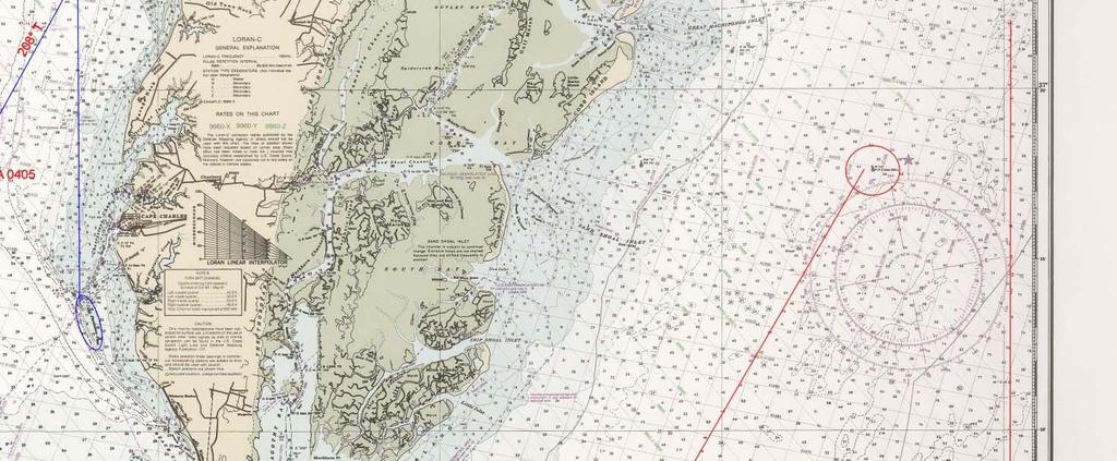
8 USCG NP-5 5) Which chart could you use for greater detail of the area at the south end of York Spit Channel? Since the question asks for the chart detail at the SOUTH end of the York Spit Channel make sure that is the area you are looking at A) B) C) D) ANSWER np-5.pdf Page 8 of 26 Copyright LAPWARE, LLC
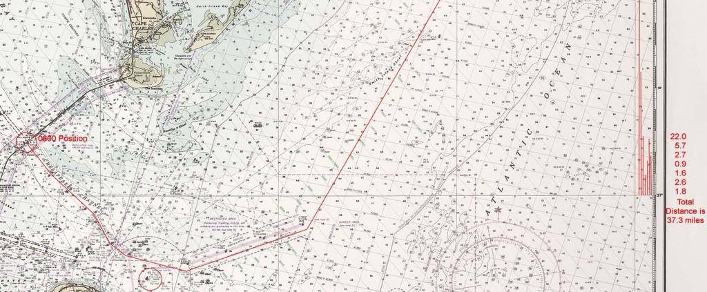
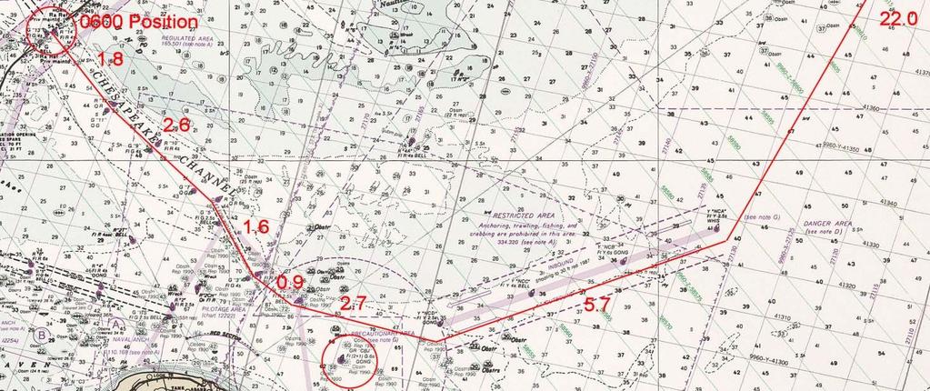
9 USCG NP-5 6) You leave York Spit Channel at buoy "14" at 0600 with an engine speed of 12 knots. You receive orders to rendezvous with the tug "Quicksilver" and her tow at Hog Island Bell Buoy "12". What is your ETA at the rendezvous point, if you pass through Chesapeake Channel to buoy "CBJ", through the outbound traffic separation lane to buoy "NCA" (LL#375), and then to the rendezvous point? This question requires you to lay down various courses from to your rendezvous. I created a total of seven (7) legs totalling a distance of 37.3 miles. Using your engine speed of 12 knots determine your ETA from your 0600 position. Your track lines might be slightly different but the overall distance should be close. Distance = Speed x Time Time = Distance / Speed Time = 37.3 / 12 Time = hours Time = 3h 06m See the plot on the next page A) 0935 B) 0910 ANSWER C) 0850 D) np-5.pdf Page 9 of 26 Copyright LAPWARE, LLC
10 00331-np-5.pdf Page 10 of 26 Copyright LAPWARE, LLC
11 USCG NP-5 7) You arrive at the rendezvous point, secure the tow, and head back southward. At 1200, you take the following bearings: Sand Shoal Inlet South Light bearing 289 pgc Cape Charles Light bearing 240 pgc What is your 1200 position? Sand Shoal Inlet South Light 289º pgc Gyro Error 0º Bearing True 289º T Cape Charles Light 240º pgc Gyro Error 0º Bearing True 240º T After determining your TRUE bearings plot your position and determine your latitude and longitude at See the plot on the next page. A) LAT ' N, LONG ' W ANSWER B) LAT ' N, LONG ' W C) LAT ' N, LONG ' W D) LAT ' N, LONG ' W np-5.pdf Page 11 of 26 Copyright LAPWARE, LLC

12 ' N, ' W np-5.pdf Page 12 of 26 Copyright LAPWARE, LLC


13 ' N, ' W np-5.pdf Page 13 of 26 Copyright LAPWARE, LLC
14 USCG NP-5 8) From your noon position, if there is no set and drift, what is your course per standard magnetic compass to the "NCA" (LL #375) buoy? Lay down your course from your 1200 postion to a point just off of buoy "NCA". You should get 209 T. Now convert that to a compass heading. A) 221 psc B) 219 psc C) 217 psc ANSWER D) 215 psc True Course 209º T Variation 10º W Magnetic 219º Deviation 2º E Compass 217º psc See the plot on the next page np-5.pdf Page 14 of 26 Copyright LAPWARE, LLC

15 209 T np-5.pdf Page 15 of 26 Copyright LAPWARE, LLC


16 USCG NP-5 9) Your gyro and electronic gear are again operating. At 1710, Chesapeake Light bears 137 pgc at 6.6 miles. The current is setting 160 T at 2 knots. At your speed of 6 knots, what is your true course to steer to remain in the inbound traffic lane? Chesapeake Light 137º G Set 160º T Gyro Error 0º 2 kts True Bearing 137º T Speed 6 kts After determining your True bearing, lay down your 1710 position. Determine your True heading to remain in the inbound traffic lane. You should get about 250 T. On your maneuvering board, plot your desired course, apply your set and drift and determine your course to steer while turning 6 knots np-5.pdf Page 16 of 26 Copyright LAPWARE, LLC
17 Lay down your true heading desired (250 T) from the center of the plot. From the center of the plot lay down your Set of 160 T and Drift of 2.0 knots. From the END of the Set and Drift line swing an arc of 6.0 miles. Where it intersects your desired heading (250 T) is your course to steer. Parallel this line to the center of the plot to determine your actual course to steer (269.5 T) T 250 T Speed arc of Set 160 T A) 250 B) 261 C) 265 D) 269 ANSWER T np-5.pdf Page 17 of 26 Copyright LAPWARE, LLC
18 LAW OF SINES B 250 A = = mi 6 miles a b c = = Sin A Sin B Sin C 6 2 = Sin 90 Sin B Sin B = 2 x Sin 90 6 Sin B = 2 = B = 19.5º 250.0º 19.5º 269.5º np-5.pdf Page 18 of 26 Copyright LAPWARE, LLC


19 USCG NP-5 10) At 1810, you obtain the following bearings: Cape Charles Light bearing 005 pgc Cape Henry Light bearing pgc What is your position? Chesapeake Light 005º G Cape Henry Light 251.5º G Gyro Error 0º Gyro Error 0.0º True Bearing 005º T True Bearing 251.5º T Plot your bearings and determine your position np-5.pdf Page 19 of 26 Copyright LAPWARE, LLC
 LAT 36 57.4' N, LONG 75 54.6' W 00335-np-5.")
20 ' N ' W A) LAT ' N, LONG ' W B) LAT ' N, LONG ' W C) LAT ' N, LONG ' W ANSWER D) LAT ' N, LONG ' W np-5.pdf Page 20 of 26 Copyright LAPWARE, LLC

21 USCG NP-5 11) What speed have you made good from 1710 to 1810? Measure your distance run from your 1710 to your 1810 position. Since it is exactly one hour the distance measured will be your speed made good knots Note: the nearest distracter is 6.3 knots and is the obvious correct selection. However, to confirm this answer I decided to solve the vessels positon from the Chesapeake Light with the bearing and range provided in question 334. Using tht position andmy position determined for my 1810 position I then solved the course and distance between 1710 and My mercator solutions resulted in a speed of 6.17 knots. A) 6.3 knots ANSWER B) 5.5 knots C) 4.9 knots D) 4.2 knots np-5.pdf Page 21 of 26 Copyright LAPWARE, LLC
22 USCG NP-5 12) If you make good a speed of 6.0 knots from your 1810 position, what is your ETA at Chesapeake Channel Lighted Bell Buoy "2C"? Measure the distance to run from your 1810 position to a point abeam of Chesapeake Channel Light Bell Buoy "2C". You should get a distance of approximately 2.3 miles. Determine your ETA with a speed made good of 6.0 knots. A) 1900 B) 1855 C) 1845 D) 1833 ANSWER Distance = Speed x Time Time = Distance / Speed Time = 2.3 / 6.0 Time = 0.38 hours Time = 23 minutes ETA np-5.pdf Page 22 of 26 Copyright LAPWARE, LLC
23 USCG NP-5 13) You passed Cape Henry Light at 0730 outbound at maximum flood. What approximate current can you expect on entering Chesapeake Channel? (NOTE: outbound should probably be inbound!) Sorry, but this question is just plain dumb. First, since Chesapeake Channel is just 4-5 miles NORTH of Cape Henry Light you would obviously experience a flooding current. Since no year or date is provided no additional information can be looked up or determined from the current tables. Secondly, question 12 requests the mariner to calculate their ETA at Chesapeake Channel Lighted Bell Buoy "2C". Answer is NOW, all of a sudden we are passing Cape Henry Light at Buoy "2C" is less then 3 miles from the Chesapeake Channel entrance. What the hell have we been doing from 1833 at buoy "2C" to a point where we enter the Chesapeake Channel entrance at 0730 outbound no less? That's almost 12 full hours and now we are heading in the opposite direction with no explanation as to why. It just does NOT make sense even though the answer to this question is obvious. A) Slack before ebb B) Slack before flood C) Flood current ANSWER D) Ebb current np-5.pdf Page 23 of 26 Copyright LAPWARE, LLC
24 USCG NP-5 14) The coastline by Cape Henry is best described as. Look up in the Coast Pilots the information requested about Cape Henry np-5.pdf Page 24 of 26 Copyright LAPWARE, LLC
25 Page 134 sandy hills about 80 feet high A) rocky with pine scrubs B) low wetlands C) sandy hills about eighty feet high ANSWER D) low and thinly wooded with many beach houses np-5.pdf Page 25 of 26 Copyright LAPWARE, LLC
 INCORRECT - but it almost makes sense since we are alternating our direction inboound, outbound and inbound again. B) INCORRECT - the color will change BEFORE you reach the bell buoy NOT AFTER.")
26 USCG NP-5 15) Inbound, the color of Cape Henry Light will. We are INBOUND again. I guess our rudder is stuck hard over! NMC going in circles! A) INCORRECT - but it almost makes sense since we are alternating our direction inboound, outbound and inbound again. B) INCORRECT - the color will change BEFORE you reach the bell buoy NOT AFTER. C) INCORRECT - the color of the light will change to a red sector and NOT remain the same. D) CORRECT - as you approach buoy "2C" INBOUND the light will change to red. A) alternate regardless of your position B) change after you reach Chesapeake Channel Lighted Bell Buoy "2C" C) remain the same D) change before you reach Chesapeake Channel Lighted Bell Buoy "2C" ANSWER np-5.pdf Page 26 of 26 Copyright LAPWARE, LLC
National Maritime Center
 National Maritime Center Providing Credentials to Mariners (Sample Examination) Page 1 of 5 Choose the best answer to the following Multiple Choice Questions. 1. The following questions are based on Chart
National Maritime Center
 National Maritime Center Providing Credentials to Mariners (Sample Examination) Page 1 of 5 Choose the best answer to the following Multiple Choice Questions. 1. (The following questions are based on Chart
National Maritime Center
 National Maritime Center Providing Credentials to Mariners U.S.C.G. Merchant Marine Exam (Sample Examination) Page 1 of 6 Choose the best answer to the following Multiple Choice Questions. 1. The following
National Maritime Center
 National Maritime Center Providing Credentials to Mariners Q163 Navigation Problems-Chart 13205 TR (Sample Examination) Page 1 of 5 Choose the best answer to the following Multiple Choice Questions. Each
Chapter IV - Sample Chart #1 Answers to Sample Chart #1
 Chapter IV - Sample Chart #1 Answers to Sample Chart #1 1. 29 10' N 2. 29 04' N 3. 28 57' N 4. 28 46' N 5. 28 38' N 6. 28 25' N 7. 28 17' N 8. 28 08' N 9. 27 51' N 10. 27 46' N Chapter IV - Sample Chart
SAMPLE COASTAL SKIPPER CHARTWORK QUESTIONS Updated 17 October 2008
 SAMPLE COASTAL SKIPPER CHARTWORK QUESTIONS Updated 17 October 2008 Unless otherwise specified, all chartwork questions relate to chart SAN 3002. Some questions may ask you to use deviation card No1 for
COXSWAIN NAVIGATION EXERCISES AUS197 NAME:
 COXSWAIN NAVIGATION EXERCISES AUS197 NAME: A deviation card is supplied at the end of this file. Check the answers Question 1 Using any chart (or use the AUS 197 extract) to: 1. Identify a distance of
Lat. & Long. Review. Angular distance N or S of equator Equator = 0º Must indicate N or S North pole = 90º N
 Navigation Part 2 1 Lesson Objectives Understand how a ships compass works and how it is used for navigation Measure distances on nautical charts Plot a course on a nautical chart Correct course headings
Chartwork Learn the basics for position fixing using a number of techniques and a simple equation for speed, distance and time.
 Chartwork Learn the basics for position fixing using a number of techniques and a simple equation for speed, distance and time. Chartwork Chartwork Tools Accurate chart work is the basis for good navigation.
OPERATIONS SEAFARER CERTIFICATION GUIDANCE NOTE SA MARITIME QUALIFICATIONS CODE. Deck: Chart Work
 Page 1 of 6 Compiled by Approved by Chief Examiner Syllabus Committee: 26 February 2013 OPERATIONS SEAFARER CERTIFICATION GUIDANCE NOTE SA MARITIME QUALIFICATIONS CODE Deck: Chart Work Page 2 of 6 COLUMN
Letter Latitude Longitude A B C D E F G
 Co-ordinates Problem Using your dividers and the chartlet on the following page complete this table. Letter Latitude Longitude A B C D E F G Nautical Charts Review. Questions 1. A Mercator projection
BK NBR ANS QUESTION CHOICE A CHOICE B CHOICE C CHOICE D ILLUSTRATION 'W 'W
 BK NBR ANS QUESTION CHOICE A CHOICE B CHOICE C CHOICE D ILLUSTRATION At 0600 your loran reads: 9960-W-14546.3; 9960-X-25909.5; LAT 41 17.1'N, LONG LAT 41 17.3'N, LONG LAT 41 17.4'N, LONG LAT 41 17.6'N,
Basic Chartwork. Necessary Tools. Navigation is the one science in which no margin whatever is left for the faker. - Felix Riesenberg
 Page 1 of 14 www.bananawind.us Navigation is the one science in which no margin whatever is left for the faker. - Felix Riesenberg Basic Chartwork You wouldn't want to attempt open ocean sailing using
National Maritime Center
 National Maritime Center Providing Credentials to Mariners (Sample Examination) Page 1 of 17 Choose the best answer to the following Multiple Choice questions. 1. Your vessel is steering 263 T at 22 knots.
Navigation Exercises for Practice Underway
 Workforms and Plotting Sheets for use with Navigation Exercises for Practice Underway www.starpath.com/kindle David Burch STARPATH Seattle, WA Copyright 2009, 2012 David Burch All rights reserved. No part
 ON SHIPS OF 200 GRT/500 GT OR MORE Assessment Sheets Enclosure (1) to CG-543 Policy Letter 11-07 ASSESSMENT NO. OICNW-1-1A COMPETENCE: Plan and conduct a passage and determine position KNOWLEDGE, UNDERSTANDING
Nautical Navigation: Final Quiz
 Name: Nautical Navigation Final Quiz Class: (ver. 03/09/15) Date: Page 1 of 9 Nautical Navigation: Final Quiz There are three sections: Multiple Choice, True/False, and Short Answer. For the multiple choice,
Delaware River Vessel Reporting System Mariners Advisory Committee For
 Delaware River Vessel Reporting System Mariners Advisory Committee For the Bay and River Delaware The Mariner's Advisory Committee is comprised of Master Mariners, River Pilots, and concerns itself with
Weems & Plath Expanding Square SAR Course Identifier #113
 Weems & Plath Expanding Square SAR Course Identifier #113 A common search pattern used in search and rescue (SAR) operations is called the expanding square pattern, which is just what it says it is. You
Anchoring Is Important
 BCC Sailing Classes - Third Theory Anchoring Anchoring Is Important 1 The Anchor is your last resort. Anchoring Keep off a lee shore. Needs to be shaped (type of anchor) to bury in the type of bottom for
Navigation for Offshore Sailing
 Navigation for Offshore Sailing This new ship here, is fitted according to the reported increase of knowledge among mankind. Namely, she is cumbered, end to end, with bells and trumpets and clocks and
Incident Report. Close Quarters Pegasus II & Distraction. 26 April 2006 Class B
 Incident Report Close Quarters Pegasus II & Distraction 26 April 2006 Class B NARRATIVE Pegasus II (See Photograph 1 Pegasus II) is a 15.46 metre commercial fishing vessel with a gross tonnage of 40. She
National Maritime Center
 National Maritime Center Providing Credentials to Mariners Q203 Navigation General-Near Coastal (Sample Examination) Page 1 of 20 Choose the best answer to the following Multiple Choice questions. 1. How
National Maritime Center
 National Maritime Center Providing Credentials to Mariners (Sample Examination) Page 1 of 17 Choose the best answer to the following Multiple Choice questions. 1. Which is TRUE concerning privately maintained
Towing Officers' Assessment Record: Near Coastal/Oceans
 Towing Officers' Assessment Record: Near Coastal/Oceans NAME: LICENSE NO.: Task No. Considered Proficient Common Element Task or Duty DE's Initials Date A. Vessel Familiarization A.1. X Locate and demonstrate
MAC Transit Advisories as of April 30, 2018
 MAC Transit Advisories as of April 30, 2018 The Mariners Advisory Committee for the Bay and River Delaware was established in October 1964. Its members and associate members are mainly comprised of master
U. S. Coast Guard Sector Boston Merrimack River Approach and Entrance, MA. Waterways Management Survey
 U. S. Coast Guard Sector Boston Merrimack River Approach and Entrance, MA. Waterways Management Survey The Waterways Analysis and Management Survey (WAMS) process is an essential component of both the
Gorgon - Pilotage - Passage Plan Materials Offloading Facility (MOF) to PBG
 to PBG") Gorgon - Pilotage - Passage Plan Materials Offloading Facility (MOF) to PBG 1.0 Introduction Vessels transiting within port limits from the Materials Offloading Facility (MOF) to the Barrow Island Pilot
Gorgon - Pilotage - Passage Plan Materials Offloading Facility (MOF) to PBG 1.0 Introduction Vessels transiting within port limits from the Materials Offloading Facility (MOF) to the Barrow Island Pilot
RECORD OF ASSESSMENT
 RECORD OF ASSESSMENT This record booklet can be used to document your completion of the proficiency assessments for Officer in Charge of the Navigational Watch (OICNW) in order to meet U.S. Coast Guard
Rules of the Road. United States Power Squadrons USPS University
 Rules of the Road United States Power Squadrons USPS University Seminar and contents copyrighted by USPS 2008 Per Inland Rules: Boats 12 m or greater must carry a copy of these rules Seminar Reference
Supplement to. Navigation Workbook for Practice Underway.
 Supplement to Navigation Workbook for Practice Underway. This file contains duplicate printable workrooms, plotting sheets, and logbook pages to use with the workbook as needed. They are the blank forms
Towing Officers' Assessment Record: Great Lakes/Inland
 Towing Officers' Assessment Record: Great Lakes/Inland NAME: LICENSE NO.: Task No. Considered Proficient Common Element Task or Duty DE's Initials Date A. Vessel Familiarization A.1. Locate and demonstrate
CALCULATING IN-FLIGHT WINDS
 CALCULATING IN-FLIGHT WINDS SITUATION: The TH of your aircraft is 350 with the TAS of 150 kts. GS has been determined to be 160 kts, and the Track is 355. What is the wind? ESTIMATE! First compare TAS
Gorgon - Pilotage - Passage Plan PBG to Materials Offloading Facility (MOF)
") 1.0 Introduction Vessels transiting within port limits from the Barrow Island Pilot Boarding Ground (PBG) to the require an approved passage plan which can be shared between Pilots and vessel Masters.
1.0 Introduction Vessels transiting within port limits from the Barrow Island Pilot Boarding Ground (PBG) to the require an approved passage plan which can be shared between Pilots and vessel Masters.
National Maritime Center
 National Maritime Center Providing Credentials to Mariners Able Seaman Unlimited, Limited, Special, Special OSV, Sail, Fishing Industry (Sample Examination) Page 1 of 17 Choose the best answer to the following
Rules Practice Exam 7
 1 INTERNATIONAL ONLY The light which may be used with a vessel's whistle is to be. A. used when the whistle is broken B. used prior to sounding the whistle C. used only at night D. a white light 2 INTERNATIONAL
National Maritime Center
 National Maritime Center Providing Credentials to Mariners (Sample Examination) Page 1 of 17 Choose the best answer to the following Multiple Choice questions. 1. The Coast Guard Captain of the Port has
Navigation & Orienteering: Pre- Test
 Name: Class: Answer Key Date: Page 1 of 7 Navigation & Orienteering: Pre- Test There are three sections: Multiple Choice, True/False, and Short Answer. For the multiple choice, please select the BEST answer
CHAPTER 8 PILOTING DEFINITION AND PURPOSE
 CHAPTER 8 PILOTING DEFINITION AND PURPOSE 800. Introduction Piloting involves navigating a vessel through restricted waters. As in all other phases of navigation, proper preparation and strict attention
Chart Features Maritime maps and Admiralty charts have these features:
 Introduction to Charts A chart or map of the area is an important safety item to carry on board. It allows the Master to obtain knowledge of the area to be travelled, and indicates the navigable channels
August April 18,2008 First Revision
 August 15 2011 Slide 01 April 18,2008 First Revision August 15, 2011 Text converted to Tables for ease of formatting instructor guide. Slide 23 Sound Signals Corrected Danger Signal 5 or More Short Blasts
Gorgon Pilotage Passage Plan - PBG to Gorgon Marine Terminal Primary Route
 Gorgon Pilotage Passage Plan - PBG to Gorgon Marine Terminal Primary Route 1.0 Introduction Vessels transiting within port limits from the Barrow Island Outer Pilot Boarding Ground (PBG) to the Gorgon
Transport Infrastructure Act 1994 Gladstone Ports Corporation. Port Notice 04/17 LNG Vessel Operating Parameters
 Transport Infrastructure Act 1994 Gladstone Ports Corporation Port Notice 04/17 LNG Vessel Operating Parameters 1. These operating parameters have been developed based on navigation simulations with LNG
National Maritime Center
 National Maritime Center Providing Credentials to Mariners (Sample Examination) Page 1 of 17 Choose the best answer to the following Multiple Choice questions. 1. The Coast Guard Captain of the Port has
CHAPTER 8 PILOTING DEFINITION AND PURPOSE
 CHAPTER 8 PILOTING DEFINITION AND PURPOSE 800. Introduction Piloting involves navigating a vessel in restricted waters and fixing its position as precisely as possible at frequent intervals. More so than
Towing Officers' Assessment Record: Western Rivers
 Towing Officers' Assessment Record: Western Rivers NAME: LICENSE NO.: Task No. Considered Proficient Common Element Task or Duty DE's Initials Date A. Vessel Familiarization A.1. X Locate and demonstrate
MITNA January Matthew Wall Scott Dynes Steve Bussolari. Wednesday, 21 January 2015
 Navigation for Offshore Sailing MITNA January 2015 Matthew Wall Scott Dynes Steve Bussolari This new ship here, is fitted according to the reported increase of knowledge among mankind. Namely, she is cumbered,
AUS small scale charts for coastal navigation. Scale: 1 to 150,000
 CHART-WORK SCALE Charts are available in different scales depending on their use. For passage planning you would use small scale charts and for close quarter manoeuvring you would use larger scale charts
28 Navigation Reminders Coastal Navigation by John C. Kelly, 2003
 28 Navigation Reminders Coastal Navigation by John C. Kelly, 2003 CRITICAL REMINDERS 1. Measure distance from latitude scales. 2. Take all bearings in degrees magnetic. 3. Always verify depth: surface
Gorgon - Pilotage - Passage Plan - PBG to Gorgon Marine Terminal - Alternative Route
 1.0 Introduction This work instruction outlines the passage plan to be used by vessels transiting from the Port of Barrow Island PBG to the Gorgon Marine Terminal, via the alternative route, with a Pilot
River Tay. Passage Plan
 River Tay Passage Plan Inward and Outward Passage Plan For the River Tay within the Port of Dundee Pilotage Area. This plan has been prepared with the co-operation of personel from The Association of Dundee
AIR NAVIGATION. Key Revision. Press F5 to start.
 AIR NAVIGATION Key Revision Press F5 to start. This presentation may be used either as a revision aid or as a self-test program. Revision Self-test Instructions This presentation may be used either as
Oil Tanker - VLCC. Yosu Inward Transit Monitoring (Entering into the Port of Yosu on a Loaded VLCC) LEG 1: APPROACHING ANCHORAGE AND PILOT STATION
 LEG 1: APPROACHING ANCHORAGE AND PILOT STATION") Yosu Inward Transit Monitoring (Entering into the Port of Yosu on a Loaded VLCC) Vessel VLCC Date 11/05/2016 Draft Fwd 21.0 D Draft Midship 21.0 Draft Aft 21.0 Max Allowed arrival draft by the port: 21.0
Yosu Inward Transit Monitoring (Entering into the Port of Yosu on a Loaded VLCC) Vessel VLCC Date 11/05/2016 Draft Fwd 21.0 D Draft Midship 21.0 Draft Aft 21.0 Max Allowed arrival draft by the port: 21.0
Section D 4: Introduction to plotting
 Boating Course Student s Notes Section 4 Section 4: Introduction to plotting 4.1 General If a boat is being conned through a winding channel where there is a great deal of boat traffic, the helmsman is
Mentoring in the USCG Auxiliary Boat Crew Program Coxswain Mentoring Template
 Notes: 1. When there is no reading assignment specified, the entire chapter contains references to the topic. 2. The study questions in the Qualification Guide should be completed for each task. Boat Crew
National Maritime Center
 National Maritime Center Providing Credentials to Mariners (Sample Examination) Page 1 of 19 Choose the best answer to the following Multiple Choice questions. 1. You are entering an African port and see
TOWING OFFICER ASSESSMENT RECORD
 TOWING OFFICER ASSESSMENT RECORD NEAR COASTAL / OCEANS SIGNATED EXAMINER INFORMATION All Designated Examiners (s) signing off successful completion of practical assessments should provide the information
MARINE NOTICE PORT OF DAMPIER
 Number: D9/2016 Date: 1/04/2016 Date of Effect: 1/04/2016 Details: Recommended Routes in Dampier Former Notice: Nil Charts & Publications: AUS 57, AUS58, AUS 59, AUS 60 and AUS 741 Further Notice: Attachments:
National Maritime Center
 National Maritime Center Providing Credentials to Mariners Q113 Navigation General-Near Coastal (Sample Examination) Page 1 of 18 Choose the best answer to the following Multiple Choice questions. 1. Your
ELEMENTARY NAVIGATION
 ELEMENTARY NAVIGATION Chart Aus191 WGS84 MARINE RESCUE NEW SOUTH WALES Elementary navigation Registered Training Organisation Version 2.0 Acknowledgements This Elementary navigation Learner s Manual was
Sail Canada Uniform Navigation Symbols and Terms
 Uniform Navigation Symbols and Terms This publication provides definitions, shows symbols and gives examples of the symbols and labels to be used on paper marine charts when planning and executing voyages.
2005 ABC. Chapter 3 Part 2. Navigating with ATON's. Revision to D-13 Local Notes. Instructor Notes for Mike Brough. Mike Brough
 2005 ABC Chapter 3 Part 2 Navigating with ATON's Revision to D-13 Local Notes Instructor Notes for Mike Brough Mike Brough June 24 2008 June 24 2008 Slide 1 June 24 2008 New graphics Navigating on Water
WORKBOOK NAVIGATION Tr. For Power-driven and Sailing Vessels DAVID BURCH LARRY BRANDT
 Piloting Dead reckoning Special publications Lights and buoys Electronic fixes Chart reading and plotting Compass use Navigation Rules Tides and currents Depth sounding navigation STARPATH This book provides
National Maritime Center
 National Maritime Center Providing Credentials to Mariners (Sample Examination) Page 1 of 16 Choose the best answer to the following Multiple Choice Questions. 1. On U.S. charts, you can tell if a named
Gorgon - Pilotage - Passage Plan - Gorgon Marine Terminal to PBG Alternative Route
 Gorgon - Pilotage - Passage Plan - Gorgon Operating Procedure - Gorgon - Pilotage - Passage Plan - Gorgon 1.0 Introduction Vessels transiting within port limits from the Gorgon Marine Terminal
Port Sections Guide Section 01
 s Guide 01 Cow Bay Marina Date 10/1/2016 Position (lat / lon) Minimum controlled water depth Chart datum Range of water densities Tidal range alongside Bottom type Dredging regime Distance pilot station
NOTICE TO MARINERS. No 03 of Port of Southampton Precautionary Area (Thorn Channel)
") NOTICE TO MARINERS No 03 of 2016 (Update and Re-Issue of Notice to Mariners No 03 of 2014) Port of Southampton Precautionary Area (Thorn Channel) 1 NOTICE IS HEREBY GIVEN that all vessels navigating within
NOTICE TO MARINERS No 03 of 2016 (Update and Re-Issue of Notice to Mariners No 03 of 2014) Port of Southampton Precautionary Area (Thorn Channel) 1 NOTICE IS HEREBY GIVEN that all vessels navigating within
CAPTAIN OF THE PORT, WESTERN ALASKA NAVIGATION SAFETY ADVISORY OPERATING GUIDELINES FOR ICE CONDITIONS IN COOK INLET
 Commander United States Coast Guard Sector Anchorage PO Box 5800 JBER, AK 99505 Staff Symbol: s Phone: 907-428-4144 Fax: 907-428-4138 16710 November 13, 2018 CAPTAIN OF THE PORT, WESTERN ALASKA NAVIGATION
iii) Satisfactory completion of approved training in the following:
 Satisfactory completion of approved training in the following:") Enclosure (1) to NVIC 13-14 DISCUSSION OF QUALIFICATION REQUIREMENTS FOR MASTER AND OFFICER IN CHARGE OF A NAVIGATIONAL WATCH ON VESSELS OF LESS THAN 500 GT LIMITED TO NEAR-COASTAL WATERS 1. GENERAL. This
Enclosure (1) to NVIC 13-14 DISCUSSION OF QUALIFICATION REQUIREMENTS FOR MASTER AND OFFICER IN CHARGE OF A NAVIGATIONAL WATCH ON VESSELS OF LESS THAN 500 GT LIMITED TO NEAR-COASTAL WATERS 1. GENERAL. This
ROUTEING MEASURES OTHER THAN TRAFFIC SEPARATION SCHEMES
 E 4 ALBERT EMBANKMENT LONDON SE1 7SR Telephone: +44 (0)20 7735 7611 Fax: +44 (0)20 7587 3210 SN.1/Circ.317 4 December 2012 ROUTEING MEASURES OTHER THAN TRAFFIC SEPARATION SCHEMES 1 The Maritime Safety
Rules Practice Exam 12
 1 INLAND ONLY You are on vessel "A", and vessel "B" desires to overtake you on your starboard side as shown. After the vessels have exchanged one blast signals, you should. Diagram 31 A. alter course to
Note to Shipbuilders, shipowners, ship Managers and Masters. Summary
 MARINE GUIDANCE NOTE MGN 301 (M+F) Manoeuvring Information on Board Ships Note to Shipbuilders, shipowners, ship Managers and Masters This note supersedes Marine Guidance Note MGN 201 (M+F) Summary The
COMDTCHANGENOTE NVIC February 21, 2017
 Commandant United States Coast Guard US Coast Guard Stop 7509 2703 Martin Luther King Jr Ave SE Washington, DC 20593-7509 Staff Symbol: CG-MMC-2 Phone: 202-372-2357 Fax: 202-372-1246 Email: MMCPolicy@uscg.mil
National Maritime Center
 National Maritime Center Providing Credentials to Mariners (Sample Examination) Page 1 of 19 Choose the best answer to the following multiple choice questions. NO reference materials are authorized for
SEMI FINAL EXAMINATION
 SEMI FINAL EXAMINATION 1. Which vessel may exhibit, if practicable, the lights for sailing vessels, but if she does not, she shall have ready at hand a electric torch or lighted lantern showing a white
Pilotage. Planning for pilotage
 Pilotage Planning for pilotage Being one step ahead of the game is key to effective pilotage. Only then will you know what to expect and what s lurking around the next bend. It s useful to construct a
PILOTAGE INFORMATION
 PILOTAGE INFORMATION Revised A PILOTAGE DIRECTIONS The Gloucester Harbour Trustees is the Competent Harbour Authority for the Gloucester Harbour under the Pilotage Act 1987 and responsible for the provision
Rules Practice Exam 14
 1 BOTH INTERNATIONAL & INLAND Additional light signals are provided in the Annexes to the Rules for vessels. A. engaged in fishing B. not under command C. engaged in towing D. under sail 2 BOTH INTERNATIONAL
APPROACH DEPTH(m) From East 15.0 From West From East 15.0 From West From East 15.0 From West ) ) From East 15.0 ) From West 16.
 From East 15.0 From West From East 15.0 From West From East 15.0 From West ) ) From East 15.0 ) From West 16.") UNIVERSAL TERMINAL (OMU) JETTY DEPTH A/S (m) APPROACH DEPTH(m) MAX LOA (m) MAX DISPL. (tonnes) REMARKS OMU1 23.0 From East 15.0 From West 22.5 346 384,604 VLCC berth OMU2 23.0 From East 15.0 From West
UNIVERSAL TERMINAL (OMU) JETTY DEPTH A/S (m) APPROACH DEPTH(m) MAX LOA (m) MAX DISPL. (tonnes) REMARKS OMU1 23.0 From East 15.0 From West 22.5 346 384,604 VLCC berth OMU2 23.0 From East 15.0 From West
National Maritime Center
 National Maritime Center Providing Credentials to Mariners U.S.C.G. Merchant Marine Exam (Sample Examination) Page 1 of 22 U.S.C.G. Merchant Marine Exam: Illustrations: 10 Choose the best answer to the
Wheatstone Marine Operations - Pilotage - Passage Plan - Onslow Port Limit to WMT
 Wheatstone Marine Operations - Pilotage - Passage Plan - Onslow Port Limit to WMT 1.0 INTRODUCTION Vessels entering the Port of Ashburton require an approved berth to berth passage plan in accordance with
Chittagong, Bangladesh (Asia Region)
") General Information: Port Information (Asia Region) Extract of port information from Chittagong Port Authority: The Port of Chittagong is the principal Port of the People's Republic of Bangladesh. It is
General Information: Port Information (Asia Region) Extract of port information from Chittagong Port Authority: The Port of Chittagong is the principal Port of the People's Republic of Bangladesh. It is
NAVIGATION AND VESSEL INSPECTION CIRCULAR NO , CH-2
 Commandant United States Coast Guard US Coast Guard Stop 7509 2703 Martin Luther King Jr. Ave. SE Washington, DC 20593-7509 Staff Symbol: CG-MMC Phone: (202) 372-2357 Fax: (202) 372-1246 E-Mail: MMCPolicy@uscg.mil
Collision in restricted visibility
 August 2013 Collision in restricted visibility It was early morning and both vessels were sailing in a busy traffic separation scheme in South East Asia. The sea was calm but there were some rain showers
Stars and Compass Trophy and Novice Paper 2014!
 Stars and Compass Trophy and Novice Paper 2014 The Stars and Compass Trophy was established to promote the use and development of traditional navigation skills. This year, in a bid to encourage novice
THE CITY UNIVERSITY OF NEW YORK KINGSBOROUGH COMMUNITY COLLEGE OFFICE OF MARITIME TECHNOLOGY MT-30 INTRODUCTION TO MARITIME TECHNOLOGY I
 THE CITY UNIVERSITY OF NEW YORK KINGSBOROUGH COMMUNITY COLLEGE OFFICE OF MARITIME TECHNOLOGY MT-30 INTRODUCTION TO MARITIME TECHNOLOGY I Anthony D. DiLernia Maritime Technology Office: T-301C Telephone:
Rule 18 - Responsibilities between vessels
 Except where Rules 9, 10 and 13 otherwise require: (a) A power-driven vessel underway shall keep out of the way of: (i) a vessel not under command; (ii) a vessel restricted in her ability to manoeuvre;
PILOTAGE DIRECTIONS REVIEWED DECEMBER 2016
 PILOTAGE DIRECTIONS REVIEWED DECEMBER 2016 REVISION LIST Revision No. Date Details Approved by: Original All sections 12 Dec 2013 First edition of C W Brand v1.0 Pilotage Directions Revision 2 all sections
West Coast Anchorages
 West Coast Anchorages This document aims to catalogue a number of anchorages along the West Coast of Tasmania where shelter may be sought. In addition the degree of protection from the wind, and holding
National Maritime Center
 National Maritime Center Providing Credentials to Mariners Q301 Rules of the Road-Inland (Sample Examination) Page 1 of 19 Choose the best answer to the following Multiple Choice Questions. NO reference
Towed Barge Standard of Care
 Lower Columbia Region Harbor Safety Committee Towed Barge Standard of Care Page 1 of 6 A. 1. Purpose The Columbia River is intended to eliminate conflicts between towing vessels conducting astern towing
Rules Practice Exam 9
 1 BOTH INTERNATIONAL & INLAND If your vessel is underway in fog and you hear one prolonged and three short blasts, this is a. A. vessel not under command B. sailing vessel C. vessel being towed (manned)
NAVIGATION AND VESSEL INSPECTION CIRCULAR NO
 Commandant United States Coast Guard 2703 Martin Luther King Jr. Ave SE Stop 7509 Washington, DC 20593-7501 Staff Symbol: CG-MMC-2 Phone: (202) 372-2357 Fax: (202) 372-4908 E-Mail: MMCPolicy@uscg.mil COMDTPUB
For the love of the Vineyard and the sea Think Sail MV
 Youth Summer sailing syllabus For the love of the Vineyard and the sea Think Sail MV Racing Seamanship Gold Vondée Silver Volvo Bronze Sail Martha s Vineyard Youth sailing syllabus Clipper Swordfish Mackerel
Enclosure (5) to NVIC 03-16
 to NVIC 03-16") TOWING OFFICER ASSESSMENT RECORD LIMITED LOCAL AREA LOCAL LIMITED AREA (LLA) TOAR INSTRUCTIONS FOR USE The following Towing Officer Assessment Record (TOAR) is intended as a model for endorsements as Limited
TOWING OFFICER ASSESSMENT RECORD LIMITED LOCAL AREA LOCAL LIMITED AREA (LLA) TOAR INSTRUCTIONS FOR USE The following Towing Officer Assessment Record (TOAR) is intended as a model for endorsements as Limited
Chapter 14. Ship Chci.racteri.stics. . P'l t' in.,.1 o ing
 Chapter 14 Ship Chci.racteri.stics. P'l t' in.,.1 o ing Up to this point it has been conveniently assumed that at the instant of an ordered course change the vessel came immediately to the new course,
NavRule Practice Exam, 70 Series Practice April 24, Labeled F (I received a reply from the testing service that all these answers were
 1. INTERNATIONAL & INLAND An all-round flashing yellow light may be exhibited by a(n)? a. vessel laying cable b. vessel towing a submerged object c. vessel not under command d. air cushion vessel 2. INTERNATIONAL
Predicted Logging Essentials
 North American Cruiser Association International Organization for Predicted Log/Cruiser Navigation Contests Predicted Logging Essentials by Ed Lloyd Prepared for the North American Cruiser Association
Rules Practice Exam 11
 1 BOTH INTERNATIONAL & INLAND While underway in fog, you hear a vessel sound one prolonged blast followed by two short blasts on the whistle. What does this signal indicate? A. A vessel towing B. A vessel
Navigation with Leeway
 Navigation with Leeway Leeway, as we shall use the term, means how much a vessel is pushed downwind of its intended course when navigating in the presence of wind. To varying extents, knowledge of this