MARINE ACCIDENT INVESTIGATION REPORT
|
|
|
- Poppy Mason
- 6 years ago
- Views:
Transcription
1 MA MARINE ACCIDENT INVESTIGATION REPORT June 26, 2009 Japan Transport Safety Board
2 The objective of the investigation conducted by the Japan Transport Safety Board in accordance with the Act for Establishment of the Japan Transport Safety Board is to determine the causes of an accident and damage incidental to such an accident, thereby preventing future accidents and reducing damage. It is not the purpose of the investigation to apportion blame or liability. Norihiro Goto Chairman, Japan Transport Safety Board Note: This report is a translation of the Japanese original investigation report. The text in Japanese shall prevail in the interpretation of the report.
3 MARINE ACCIDENT INVESTIGATION REPORT Vessel type and name: Fishing vessel, Nikko-maru Fishing vessel registration number: AM Gross tonnage: 5.1 tons Accident Type: Date and time: Location: Foundering approximately 03:44, April 5, 2008 (local time, UTC+9 hours) Offshore from the Kugurizaka Fishing Port, Aomori City, Aomori Prefecture 315 true, around 1,600 m from the Kugurizaka Port Western Breakwater Lighthouse (approximately N, E) June 11, 2009 Adopted by the Japan Transport Safety Board Chairman Norihiro Goto Member Yukio Kusuki Member Tetsuo Yokoyama Member Tetsuya Yamamoto Member Mina Nemoto 1 PROCESS AND PROGRESS OF THE INVESTIGATION 1.1 Summary of the Accident The fishing vessel Nikko-maru set sail from the Kugurizaka Fishing Port, Aomori City, Aomori Prefecture at approximately 02:00 hours on April 5, 2008, with seven persons aboard in addition to the captain, for the purpose of harvesting a scallop farm, and, having harvested the farmed scallops at the scallop farming facilities off the shore of the same fishing port in Mutsu Bay, was returning to port when it sunk at approximately 03:44 hours killing all eight persons on board. 1.2 Outline of the Accident Investigation Appointment of Investigators The Japan Transport Safety Board (JTSB) took over this accident investigation from the Sendai Marine Accident Investigators' Office on October 1, 2008, and appointed an investigator-incharge as well as one marine accident investigator to carry out the investigation Collection of Evidence April 18, 25, 2008: On-site investigation May 19, 20, October 2, 20, 2008: Interviews 1
4 September 9, 2008: collection of questionnaire Tests and Research by Other Institute Analysis into the stability of the Nikko-maru in regards to this accident was entrust to the National Maritime Research Institute Comments from Parties Concerned Due to the fact that all hands perished in this accident, comments from the captain and crew as parties relevant to the cause of the accident were not taken. 2 FACTUAL INFORMATION 2.1 Events Leading to the Accident On the day of the accident, according to interviews with the captains of the five other consort ships that left Kugurizaka Fishing Port with the Nikko-maru (hereafter, these captains are referred to as Captains B through F, the five ships as Ships B through F, and the Nikko-maru as Ship A) and the responsible persons at the Fisheries Cooperative Association (hereafter, the FCA), the way in which this accident occurred was as follows. Note that the hull of Ship A was investigated and the GPS plotter was discovered by the Aomori Coast Guard Office, but the route of the ship could not be traced Leaving port At approximately 01:50 hours on April 5, 2008, Ship D left port from its anchorage at Kugurizaka Fishing Port, Aomori City ahead of the other five ships starting at 02:10 hours, Ship F, Ship B, and Ship C left port, and finally Ship E left port at approximately 02:30 hours. Ship A, with seven people on board in addition to the captain, left this port and, according to interviews with FCA personnel, headed towards the fishing grounds (scallop farm facilities) around 2,100 m north-west from the Kugurizaka Port Western Breakwater Lighthouse Arrival at fishing grounds (operation commencement) With the exception of one ship, Ship E, that got lost along the way, the remaining four consort ships took approximately 10 minutes from leaving port to arriving at the fishing grounds. According to interviews with Captains C and F, Ship A carried out its operations by using the crane that was normally carried on board to pull up a chain 1 of pearl nets (basket: see Fig. 2) with scallops from the port side, bring them inside, and load them on its deck During operations According to the interviews with the captains of the five sister ships, during the operations winds grew strong and the waves grew high, with a north-westerly to south-westerly wind of 3 to 10 1 A chain refers to a string of around 10 pearl nets on a branch line. 2
5 m/s, and waves from the west about 1 to 3 m in height. Due to the worsening sea conditions, four of the six ships stopped operations, with the exceptions of Ship A and Ship F. According to the interviews with Captains C and F, Ship A raised up a branch line on which one mainline of pearl nets was hanging and loaded it on board. According to the supervisor of the Kugurizaka branch of the Aomori City FCA, Ship A s scheduled loading amount on the day of the accident was between 2.5 and 3.0 tons (one mainline worth). According to interviews with Captains D and E, it takes about 1 hour to 1 hour and 10 minutes to load one mainline worth of pearl nets Leaving the fishing grounds (operation close) Captain B was the first to return to port, but at approximately 03:15 when Ship B left the fishing grounds he saw the lights of five ships, including Ship A. Captain E saw Ship A bringing in its pearl net at approximately 03:10. Later, Ship E was the last to leave the fishing grounds after Ship A, and entered the Kugurizaka Fishing Port at approximately 03:40. By 03:40, five of the consort ships had returned to port, but Ship A had not yet returned. Captain C believed that Ship A had stowed a crane when she was empty, but since it always swung its crane out when she was at the fishing grounds, he believed that it swung the crane out on the opposite side of the catch to maintain balance. Captain E believed that Ship A always had its crane swinging out when it returned to port, so that Ship A had the crane out to maintain balance. The time and date of this accident were approximately 03:44 on April 5, 2008, and the location of the accident was in the vicinity of 1,600 m north-west of the Kugurizaka Port Western Breakwater Lighthouse. (See Fig. 1: Kugurizaka Fishing Port, the Fishing Grounds of Ship A and its Consort Ships, the Discovery Location of the Sunken Ship A (outline map) (See Fig. 2: Standard Scallop Farm) 2.2 Injuries to Persons According to the coroner's report, all eight crew members on board Ship A died from drowning. Additionally, as noted in below, none of the crew was wearing lifejackets at the time of discovery. 2.3 Damage to Vessel There was no damage to the hull of the sunken Ship A. 2.4 Crew Information Captain of Ship A (hereafter, Captain A) (1) Gender, age, and certificate of competency Male, aged 74 years First class boat s operator / Personal water craft s operator Date of issue: Sept. 11, 1975 Date of revalidation: Jan. 27,
6 (Valid until Dec. 16, 2010) (2) Fishing career and others Captain A was the representative director and union president of the Aomori City FCA. According to interviews with FCA personnel, Captain A was a 50-year veteran of fishing, had worked as a director of the Aomori City FCA since his 30s, and was a leader of the local fishermen, admired by all Information Regarding Other Crew Members According to the questionnaire from the Kugurizaka branch of the Aomori City FCA, of the other seven crew members, one was a full-time fisherman, and the other six were part-timers. According to interviews with FCA personnel, the six part-timers were regulars. 2.5 Vessel Information Particulars of Vessel Fishing vessel registration number AM Base port Aomori City, Aomori Prefecture Affiliated FCA Aomori City Fisheries Cooperative Association Owner Individually owned Gross Tonnage 5.1 tons L B D m 3.09 m 0.83 m Hull material FRP Engine Single diesel engine Output 59 kw (Fishing Vessel Act horsepower value) Radio installations A3E 1W (27 MHz transceiver) Date of launching August 10, 1986 Fishing Type and Purpose Gathering seaweed and set-net fishery (See Fig. 3: General Arrangement of Ship A (outline plan)) Fishing equipment Ship A was equipped with a crane (maximum lifting capacity: 500 kgf; Maximum operating radius: 8.0 m, fully rotational, total weight: 700 kgf) with an extendable boom in front of the wheelhouse and one electric roller aft of the wheelhouse on the port side Speed capabilities, etc. According to interviews with the captains of the consort ships, the maximum speed of Ship A was between 30 and 35 km/h. According to the shipbuilder of Ship A, Ship A was designed so that the central part of the hull was extended 0.70 m over the standard model and added a wheelhouse over the engine room Loading status According to materials released by the Aomori Coast Guard Office, at the time of the discovery of the accident, Ship A had one mainline with 440 chains, roughly 4.5 tons in weight carried on board. 4
7 According to interviews with the captains of two consort ships of a similar tonnage to Ship A (Ships E and F), when pearl nets attached to one mainline are stacked evenly both port and starboard, the height above the deck for their ships is between 1.5 and 1.7 m. Also, the captains reported that the nets are stacked to ensure that they do not pile up only on one side and so that the crane can be stowed during sailing. According to the result of questionnaire from the Kugurizaka branch of the Aomori City FCA, the total combined weight of all eight crew members of Ship A was 0.54 tons. 2.6 Meteorological and Sea Conditions Observations of the consort ship captains Combining interviews with the consort ship captains, the conditions were as follows: At approximately 02:00, the time of departure on April 5th, the wind was south-west at 2 to 3 m/s, and the wave height was 0.5 to 1 m. When four of the six ships that left port ceased operations at between 02:40 and 03:30, the wind was north-west to south-west at 5 to 10 m/s and the waves were from the west at a height of 1 to 3 m. Additionally, the weather was cloudy with occasional rain or snow for brief periods, but the visibility was not impaired Observation data by the Aquaculture Institute, Aomori Prefectural Fisheries Research Center (1) Aomori Buoy (anchored location: North East ) Water temperature 1 m below the sea surface as of 04:00 on April 5th: 7.53 C (2) Eastern Bay Buoy (anchored location: N E) Date / Time Wind Direction (True bearing) Wind Velocity Temperature 03:00, April 5th m/s 6.4 C 04:00, April 5th m/s 3.8 C Additionally, the current rate from 04:00 on April 5th to 15:00 on April 7th, calculated based on the hourly current rate measurement values at a water depth of 15 m at the Eastern Bay Buoy, was a maximum of 0.12 m/s and a minimum of 0.01 m/s, with an average of 0.06 m/s Advisory and coastal wave analysis chart issued by Aomori Local Meteorological Observatory (1) Advisory The announcement at 17:57 on April 4th was as follows: Tosei Tsugaru 2 : [ongoing] Strong wind and wave advisory Wind: Until the evening of the 5th: South-west wind Maximum wind velocity: On land: 13 m/s Waves: From late on the night of the 4th to before noon on the 5th, with a peak on the morning of the 5th 2 Tosei Tsugaru is a regional division name of the Meteorological Agency and refers to Aomori City and East Tsugaru-gun (Hiranai-town, Imabetsu- town, Yomogita-village, and Sotogahama- town). 5
8 Wave height 3 : 3 m Additional notes: Gusts, hail (2) Coastal wave analysis chart According to the coastal wave situational map, the waves were from the west-south-west at a height of 2.2 m and the wind was from the west-north-west at a speed of 17 kn (approx. 8.8 m/s) at 09:00 on April 5th on Point X on that map, relatively close to the accident site (Tsugaru Strait (Japan Sea side): N E). (Refer to Fig. 4: Coastal Waves Situational Map (as of 09:00 on April 5th)) Observed values at the accident site according to materials released by the Aomori Coast Guard Office (time of observation: 05:40,announced at 09:45, April 5th): Weather: cloudy, west wind at 13 m/s, swell of 3 m, visibility of 4,000 m Observed values of the Nationwide Ocean Wave information network for Ports and HArbourS (NOWPHAS) The significant wave periods in Aomori Port on April 5th were as follows: Observed Time 03:00 03:20 03:40 04:00 Significant Wave Period 3.0 s 2.7 s 2.6 s 2.6 s 2.7 Wakes Due to Large Vessels and other vessels According to the Kugurizaka branch of the Aomori City FCA, since the area in the vicinity of the accident site contains scallop farming facilities, there are no conducts of large vessels or high speed craft, and thus no wakes from them. 2.8 Information Relating to Vessel Operation Management and other subjects Related applicable laws According to Article 32 of the Ship Safety Act, fishing vessels of less than 20 gross tonnage (those that operate exclusively in seas not more than 12 nautical miles (M) from the coast of Japan) do not fall under the jurisdiction of the Ship Safety Act, consequently Ship A was not required to have lifesaving equipment on board, nor were any stability criteria or similar matters applicable. According to Article 1 of the Mariners Act, fishing vessels of less than 30 gross tonnage and which fit the requirements determined by regulation, such as Ship A, are not applied by the Mariners Act. However, Captain A was required by Article 23-2 of the Seaman and Small Craft Operator Act (hereafter, the Seaman Act) to possess a Small Craft Operator s License. Moreover, according to Article of the Seaman Act, articles of compliance for operators of small crafts are specified. These include requirements for such provisions as making the crew wear lifejackets (Article 23, Section 4). In Article 137 of the Seaman Act Enforcement Regulations, it is specified that lifejackets must be worn when on the exposed deck of a small craft. However, this is not a mandatory requirement, but simply an advisory regulation that advises the wearing of life jackets. 3 The predicted wave height is the significant wave height (the height of the waves over a given period of time is measured and the average value of the height of 1/3 of the higher waves is taken). 6
9 Furthermore, Captain A was an entrepreneur according to the Industrial Safety and Health Act, and was legally required to implement risk prevention measures. Specifically of note is Article 531 of the Industrial Safety and Health Regulations. As a measure for workers (in this case, the crew of Ship A) being transported to the worksite on a vessel, this Article required Captain A to take measures to prevent risk from capsizing, sinking, and falling, such as the provision of life saving equipment. In Articles 11 and 87 of the Fishery Cooperative Act, it is specified that the FCA and its Association may carry out projects related to the prevention of accidents or rescuing in the event of accidents for crew members Safety management in scallop fishing vessel (1) Determination of cessation of fishing or of operations According to interviews with the captains of the consort ships, the criteria are as follows: The decision whether to cease fishing in rough weather is made by the captain of each ship. There are no particular pre-determined criteria for ceasing work, and the decision is made based on each captain s experience. When a decision was difficult, communication was occasionally made with the ship that started fishing first to obtain local information as the material on which the determination can be made. The decision to cease operations when the weather turns rough during operations was also made by each captain. There are no particular pre-determined criteria for ceasing operations, and the decision was made from each captain s experience. At the time of clearing port on April 5th, since it was determined that the sea conditions were such that there would be no problems in fishing, the six ships clear out. However, since the meteorology and sea conditions deteriorated, four of the six vessels captains determined to cease operations partway through, and returned to port without having reached their scheduled catch for the day. While operating, there were no radio communications between the vessels. (2) Roles on board ship According to interviews with Captain E, the captain manoeuvres the ship, and the other crew members carry out the work of withdrawing the pearl nets. A synthesis of the interviews with the captains of the consort ships indicates that instructions, such as the method for raising the pearl nets and the use of lifejackets, are given from the captain to the crew. (3) Use of lifejackets A synthesis of the interviews with the captains of the consort ships indicates that at the time of the accident, five ships out of the entire fleet were carrying life jackets equal to at least the number of crew on board, but only on one ship had the captain given directions that each crew member must wear one. There were two life jackets remaining in the wheelhouse of Ship A, but it is unknown whether the remaining six were originally there or not. There were no life jackets found in the flotsam discovered during the search and rescue operation. (4) Instructions related to excessive loading by the shipbuilder According to the shipbuilder, 24 years had passed since Ship A was constructed, and there are no records extant relating to actual safety instruction given to Captain A, its owner. Note that at 7
10 present, in fishing vessel owner manuals, users are warned to ensure sufficient freeboard, and that the vessel must be operated within limits that will not cause the draught to exceed the draught limit mark on the central part of the ship s hull Safety management in the Federation of Fisheries Cooperative Associations and others (1) Related organizations According to interviews with related persons such as FCA personnel, the facts are as follows: A demarcated fishery right from the Governor of Aomori Prefecture is granted to the FCA (the fishery right for the scallop aquaculture zone of the Kugurizaka branch is granted to the Aomori City FCA). The Aomori Prefecture Federation of Fisheries Cooperative Associations (hereafter, the PFFCA) members are each FCA in Aomori Prefecture, and have a cooperative sales relationship for scallop sales, as detailed in below. (2) Safety management by the FCA and the PFFCA According to interviews with related persons such as FCA personnel, etc., the following is the case: In the Kugurizaka branch of the Aomori City FCA to which Ship A belonged, there had not been a fishing vessel accident in nearly 60 years of scallop fishing. Instructions to wear lifejackets were given, but did not have an effect. Additionally, instruction was given on prohibitions on overloading and to take breaks from fishing during stormy weather rather than take risks. However, the FCA and its branches were not involved in the decisions to cease fishing or cease operations. In the Kugurizaka branch of the Aomori City FCA, following the accident, there is an oral consent among the owners of the vessels that crew members on scallop fishing vessels should wear life jackets, and additionally that when the wind velocity was 5 m/s or greater, the owners would gather before departure and determine whether vessels sailed out fishing. There are no radio facilities at the Kugurizaka branch, and contact between the branch and the Association fishing vessels is conducted exclusively by a cellular phone, but when a cellular phone contact cannot be established, it is possible to contact those that are out fishing by radio of mooring fishing vessels. The PFFCA has carried out instructions on general items such as the wearing of lifejackets in its regular classes on preventing maritime accidents. (3) Similar accidents According to interviews with related persons such as FCA personnel, two years prior to the accident of Ship A, there was a capsizing accident of a scallop fishing vessel in the Aomori City FCA Harabetsu branch. However, since all crew members were wearing life jackets, they were all safe. According to the written judgments of the Japan Marine Accident Inquiry Agency, there have been 15 capsizing accidents (including two written judgments of the Sendai Marine Accident Inquiry Agency, to which Aomori Prefecture is within the jurisdiction) of scallop fishing vessels over the past 20 years (from 1989 to 2008), and of those, 12 were during scallop hoisting operations (8 were related to crane operation, and 4 were related to cargo collapses), and two were related to cargo collapses while under way. 8
11 2.8.4 Gross tonnage of scallop fishing vessels and others (1) Number and sizes of scallop fishing vessels According to materials provided by Aomori Prefecture, there are 2,172 scallop fishing vessels operating in Mutsu Bay (those vessels with a fishing type designated as shellfish and seaweed gatherers in the vessel master register), and the distributions of their gross tonnages and overall lengths are as shown in the tables below. Ship A belonged to the largest class of these. Gross Tonnage Number of Vessels Less than 3 tons tons or over and less than 5 tons 1,180 5 tons and over 7 Overall Length Number of Vessels Less than 9 m m and over and less than 13 m 1, m and over 11 (2) Cranes and others 1) Cranes According to the Aomori City FCA, only 7 to 8 of its fishing vessels are scallop fishing vessels equipped with cranes, and the cranes are used for lifting things out of the water. According to the PFFCA, it is not common for vessels to be equipped with cranes, and the amount lifted by the Kugurizaka branch vessels is about 2 to 3 tons of scallops per day. 2) Number of crew members, including the captain According to the Aomori City FCA, though the number of crew members differs according to the size and shipping volume of the vessel, the minimum is 4 persons in shipment season. The owner of the ship arranges part-timers, and the FCA is not involved. However, there are many regulars among the part-timers. According to interviews with the captains of the consort vessels, the number of crew members per fishing vessel of the six scallop fishing vessels belonging to the Kugurizaka branch that went out on April 5th was 4 or 5 persons for four vessels, 7 persons on one vessel, and 8 persons on one vessel (Ship A) Distribution system of scallops According to interviews with related persons such as FCA personnel, the way scallops are distributed is as follows: The PFFCA regularly makes bids and then contracts with the designated buyer (hereafter, the processor). The FCA branch is directly informed of the amount ordered each day by the processor, and the amount of that order is divided up by the FCA branch among the fishing vessels belonging to the Association. The scallops brought up to the surface on a given day are weighed at the Kugurizaka branch at 05:45 and taken by the processor s truck to the processing plant. After weighing, the bills are sent from each FCA to the PFFCA, where the money is collected by the PFFCA from the processor, the 9
12 service fees are subtracted, and the remainder is paid out to each FCA. The fishing season for scallops in the Aomori City FCA is from April to July, and from August to March there is no harvesting related to aquaculture. Farmed scallop fishing is done with each ship s aquaculture facilities separated from the others, and not in a close fleet. However, since there is a need to ship the amount ordered from the processor as an FCA branch unit, and, additionally, since weight amounts and shipping times are preset, the number of ships equivalent to the amount ordered leaves port at approximately 02:00. Following their return at approximately 04:00, the scallops are sorted out. April 5th, the date of this accident, was the first day of fishing for the year. Captain A was presumably eager to hand over to the processor the full amount of his share, from his position as union president. The Kugurizaka branch of the Aomori City FCA has 22 persons engaged in scallop aquaculture as members. On April 5th, six fishing vessels including Ship A left port to bring up the ordered amount. Ship A was scheduled to bring up between 2.5 and 3.0 tons of scallops. 2.9 Medical Information According to the questionnaires from the Kugurizaka branch of the Aomori City FCA, on the day of the accident, the health statuses of all eight crew members on board Ship were was good, and they were wearing upper body and lower body wet weather gear, sweaters and other clothing on the upper portion of their bodies, and thermal pants etc. on their legs, with underwear under that and rubber gloves. However, it does not appear that they were wearing life jackets. According to the International Aeronautical and Maritime Search and Rescue (IAMSAR) Manual jointly prepared by the IMO and the ICAO, the survival time in water between 4 and 10 C is, when dressed normally, less than three hours Information Relating to Searches and Rescues Initial searches (1) According to interviews with a witness on land (hereafter, Witness G), the matter is as follows: At approximately 03:30 on April 5th, two fishing vessels, one of which is presumed to be Ship A, could be seen operating off the coast. A little before 04:00, Witness G realized that Ship A had not returned to port, nor could Witness G see any lights out to see. Witness G attempted to raise Ship A on the radio of a consort ship, but there was no response. Later, one ship that had not been fishing headed out to search, but turned back due to poor sea conditions. Contact notifying that Ship A was lost at sea was made to the Aomori Coast Guard Office at approximately 04:35. (2) According to a report from the Aomori Coast Guard Office, the situation that followed was as follows: According to the first report released by the Aomori Coast Guard Office (announced at 06:15), the first search by the Japan Coast Guard used one patrol vessel and two patrol craft attached to the 2nd Regional Coast Guard Headquarters and one helicopter attached to the Hakodate Air Base, Japan Coast Guard. Upon the third report (announced at 08:25), six special rescue team members, one patrol vessel, and one aircraft were added. At 05:30, the head office of task force for this 10
13 accident was set up in the 2nd Regional Coast Guard Headquarters and the local office of task force was set up in the Aomori Coast Guard Office. Additionally, according to the fourth report (announced at 09:45), two Aomori Prefecture helicopters and three Maritime Self-Defense Force helicopters conducted the search, and according to the seventh report (announced at 13:35), five scallop fishing vessels from the Aomori City FCA searched Discovery of the crew According to a report from the Aomori Coast Guard Office, the background and situation of the discovery of the crew was as follows: At 06:35 on the day of the accident, April 5th, the helicopter of the Coast Guard discovered one person adrift in the vicinity of 0.8 M north of Utoumai. However, death was confirmed at 08:10 at the hospital to which the crew was sent, and the autopsy revealed death by suffocation from drowning (respiratory failure). The trousers of the wet weather gear of this crew were found at 08:30 the following day, the 6th, approximately 800 m from the location at which the crew had been found, on the coast of Kagikake, Tsuchiya, Hiranai-town. At approximately 16:50 on the 6th, one body was found by the special rescue team of the Japan Coast Guard in the sea in the vicinity of 0.7 M north-north-west from the Kugurizaka Port Western Breakwater. At approximately 15:40 on the 7th, the body of Captain A was found in the wheelhouse of Ship A discovered on the seabed in the vicinity of 1600 m north-west from the Kugurizaka Port Western Breakwater. At approximately 16:30 on the 7th, three bodies were found by the divers arranged by the FCA on the seabed in the vicinity of 2200 m north from the Kugurizaka Port Western Breakwater. At approximately 17:10 on May 24th, one body was found adrift by a civilian out fishing in the vicinity of 3400 m north-north-east of the Kugurizaka Port Western Breakwater. At approximately 17:40 on July 22nd, one body was found adrift by a fishery worker in the vicinity of 650 m south-south west from the Shigeura Port Western Breakwater. When they were discovered, none of the crew members were wearing life jackets. (Refer to Fig. 5 Discovery Locations of Crew Members (outline map)) Discovery of the ship At approximately 14:45 on April 7th, the capsized Ship A was discovered by the special rescue team of the Japan Coast Guard on the sea bed (sea depth: approx m) 1600 m northwest from the Kugurizaka Port Western Breakwater. According to Japan Coast Guard materials, the crane was swung out over the port side and the stowable rudder was not visible from the bottom of the hull. There was nothing twisted up in the propeller. The bow of the sunken Ship A was facing Investigation on the refloated ship body The state of the refloated Ship A was as follows: The ship s chronometer in the wheelhouse was stopped at 03:44 and the main engine remote controller was in neutral position. The helm direction was showing 75 to the left and two life jackets were remaining (one inflatable type and one vest type). The switches for searchlight and 11
14 clear view screen were all still on (according to interviews with Captain C and Witness G, the searchlight was normally turned on when the scallops were all lifted up and the ship was leaving the scallop farm). On deck, the hatches to the fish hold and others were not closed. The crane was extended about 7.2 m and at an elevation angle of 43. It was swung out approximately 45 to the port bow (the length of the crane and the angle it was swung out are according to Aomori Coast Guard Office materials). The hook at the end of the crane wire was fastened with rope to the trunk of the crane so that it would not move, and the operating levers were in the off position. There were freeing ports 15 cm wide and 4 cm high in five places both port and starboard, but the freeing port closest to the bow on both sides were blocked up. There was a stanchion 0.7 m tall and 2.0 m wide topped on the 0.5 m bulwark of the starboard. The stowable rudder was raised up into the deck and the steering wheel was pointing the same way as the rudder angle indicator to the left. (Refer to Photo 1 Ship A After Refloated) 2.11 Estimations for Fact-Finding Calculations by the shipbuilder The shipbuilder of Ship A carried out five reconstructive calculations of Ship A following the accident. With these calculations, the weight, center of gravity, and other factors were calculated, and it was possible to obtain the cross curves of stability 4 for the five cases of when it was new and fully fueled and loaded with a crane normally (the state it would be before loading on the catch), and then when 1.8 t, t, 3.6 t, and 5.4 t of cargoes (in order, State 1, State 2, State 3, and State 4) have been added to the normal state. With these calculations by the shipbuilder (calculated with the buoyancy extents up to the upper edge of the bulwarks), it was found that the righting arm in the normally equipped state was a maximum of approximately 0.58 m at an angle of heel of 40. (Refer to Fig. 6 Cross Curves of Stability for Ship A Created by its Shipbuilder) Analysis by the National Maritime Research Institute Building on the calculation results described in , an analysis was carried out by the National Maritime Research Institute (hereafter, NMRI), which was asked to quantitatively determine the atmospheric and sea conditions that could cause Ship A to heel to the extent where the angle of heel was such that it lost its ability to upright itself (stability) and the angle at which water would enter, in the situation where there was a similar load, crew, and crane extension to when Ship A was operating. The calculation conditions, as described in 2.5.4, employed weights of the pearl net and others at the time of the accident of 4.5 t. And because the height of the load was unknown, but if spread evenly would be between 1.5 and 1.7 m, calculations were made to determine stability for the three cases of 1.5 m, 1.75 m, and 2.0 m load height. The crane situation in these three cases was calculated with the crane in the position it was in when Ship A was found as described in In order to 4 The cross curves of stability are the plots on a graph of the values of the righting lever (GZ: the lever length of the moment of a couple that attempts to right the heel) for a given displacement and angle of heel. 12
15 evaluate the effect of the crane being swung out, the same stability calculations were also carried out for when the pearl nets were stowed at an even height of 1.5 m and the crane was stowed low. (Refer to Fig. 7 NMRI Analysis Results Regarding Stability at the Time of Leaving Port and the Time of the Accident (outline)) As a result, the stability of Ship A when it left port on the day of the accident and when it had the accident (with the pearl nets on board) was calculated. (1) Stability at the time of leaving port 1) Righting lever When buoyancy is up to the top edge of the upper deck, the righting lever in the state when the ship left port is a maximum of approximately 0.4 m at a heel angle of 25. (Refer to 2. Right lever curves in Fig. 7) 2) Natural roll period The natural roll period of Ship A when it left port was 2.01 s. (Refer to 3. Resonant Roll due to Beam Wave in Fig. 7) (2) Stability at the time of the accident 1) Resonant rolling When Ship A started to cause resonant roll, the resonant roll angle was 26.3 and the natural roll period was 2.85 to 3.03 s. Also, the wave conditions for resonant roll were a wind velocity of 10 to 13 m/s and a wave height of 1.26 to 1.43 m. Additionally, the heel angle for water to come over the top edge of the bulwarks while loaded at the time of the accident was (Refer to 3. Resonant Rolling due to Beam Wave in Fig. 7) 2) Stability when the center of gravity shifts due to load collapse during resonant roll When the pearl nets were loaded on the deck to a height of 1.75 m, if the center of gravity of the pearl nets was moved laterally by 0.6 m (less than a quarter of the breadth), then the ship would capsize. Otherwise, if the pearl nets were loaded to a height of 1.5 m, the ship would not capsize even if the center of gravity moved laterally by 0.6 m. (Refer to 4. (1) Accident Scenario 1 in Fig. 7) 3) Stability when the center of gravity shifts due to movement of the crew during resonant roll If the pearl nets are loaded to a height of 1.5 m or greater and the crane is swung out, then if the crew other than Captain A move by 0.9 m laterally, then the ship would capsize. Otherwise, even if the pearl nets are loaded to a height of 1.5 m or more, if the crane is stowed, then even if the crew members other than Captain A move by 0.9 m laterally, the ship would not capsize. (Refer to 4. (2) Accident Scenario 2 in Fig. 7) 4) Stability when the ship is hit by a lateral wind during resonant roll If the pearl nets are loaded to a height of 1.5 m or greater and the crane is swung out, then if the ship is hit by a lateral wind of 10 m/s, it will capsize. Conversely, even if the pearl nets are loaded to a height of 1.5 m or more, if the crane is stowed, even if the ship is hit by a lateral wind of 10 m/s, it will not capsize. However, it will capsize if it is hit by a lateral wind of 13 m/s. (Refer to 4. (3) Accident Scenario 3 in Fig. 7) 13
16 3 ANALYSIS 3.1 Situation of the Accident Occurrence History of the voyage (1) Time of Ship A leaving port It is probable that it was approximately 02:15 from the following 1) and 2). 1) According to the interviews of 2.1.1, it is probable that the time of Ship A leaving port was between 02:10 and 02:30. 2) According to the interviews of 2.1.4, the last vessel to return to port, Ship E, arrived in port at approximately 03:40. And in consideration of the fact that it took some 10 minutes to traverse the distance from the fishing port in to the fishing grounds, it is probable that Ship A finished raising its 440 chains by approximately 03:30 and started back to port. According to the interviews in that it takes 60 to 70 minutes to reel in one mainline worth of pearl nets, from a reverse calculation it is probable that Ship A arrived at the fishing grounds at approximately 02:25 and began operations. Since it takes 10 minutes from the port to the fishing grounds, it is probable that Ship A left port at approximately 02:15. (2) Ship A s fishing grounds As described in 2.1.1, it is probable that Ship A's fishing grounds was the scallop farm in the vicinity of 2100 m north-west of the Kugurizaka Port Western Breakwater. (3) Time of arrival of Ship A to the fishing ground From (1) 2), it is probable that Ship A arrived at the fishing ground at approximately 02:25. (4) Time of Ship A leaving the fishing ground From (1) 2), it is probable that Ship A left the fishing ground at approximately 03:30. (5) Ship A s return course to port Since the shortest course from the fishing ground to return to the Kugurizaka Fishing Port is on a heading of roughly 135, and the site where the ship foundered (described below) is also on this course, it is probable that the course of Ship A was roughly Time of accident (1) Time of accident According to the following 1) and 2), it is probable that the time of the accident was approximately 03:44. 1) Interviews with the witness on shore According to the interview of , at approximately 03:30 Ship A was still operating, and a little before 04:00 its lights were no longer visible. 2) Discovered ship chronometer from Ship A As described in , the chronometer was stopped pointing to 03:44. (2) Time taken to founder From the following 1) to 3), it is probable that the vessel foundered in a short period of time. 1) As described in , the body of Captain A was discovered in the wheelhouse. 2) As described in and , there were at least two life jackets available in the wheelhouse, but none of the recovered crew members were wearing one. 14
17 3) According to the interview in , there was no communication by radio or cellular phone asking for help Location of the accident As described in 2.5.4, one mainline worth of pearl nets had been brought up. And, as described in , the hook on the crane was fastened down, the switches for searchlight and clear view screen were on, and from the positional relationship of the fishing grounds and the location that Ship A was discovered (Refer to Fig. 1), it is probable that the accident occurred during the return to port. The currents in Mutsu Bay are generally light, and the measurement value at a location relatively close to the fishing grounds in was approximately 0.06 m/s, so it is not probable that the hull drifted much following the accident. Therefore, it is probable that the location of the accident was in the vicinity of 1600 m north-west from the Kugurizaka Port Western Breakwater. 3.2 Causal Factors of the Accident Situation of the ship handling and cargo loading (1) Ship manoeuvering From 2.4, Captain A held an appropriate and valid boat operator's license, and had sufficient experience on ships. As described in , Ship A was discovered with the helm 75 to port, but at the same time, the main engine remote controller was in neutral. So, it is not known whether the vessel had any speed. The rudder was also raised up to the deck, which mean that it is not known whether Ship A was turning at the time of the accident. Additionally, as described in (5), the return course to port is considered to be generally 135. And, as described in , the bow of the ship was facing 080 when it foundered, but it is not certain whether this 55 change in bow heading was caused by Ship A turning or from uneven pressure flow during its submergence from the sea surface to the bed. (2) Amount and method of loading pearl nets As described in 2.5.4, it is probable that the load was approximately 4.5 t with 440 chains. From the interviews with the consort ship captains in and the state of Ship A as described in , it is probable that Ship A had piled the raised pearl nets on the starboard side on the deck, and in order to balance the vessel, had sailed with the crane swung out to the port. The height to which the pearl nets were piled is not known. However, as described in 2.5.4, with an uneven pile, it is probable that they were piled to a height of at least 1.5 m or so for Ship A. As described in , it is somewhat likely that the stanchion on top of the bulwarks on the starboard side was placed to prevent the piled up pearl nets from sliding over the edge of the vessel. If the pearl nets were piled to a height of nearly 2 m, they would have limited the visibility to the starboard side. And, it is probable that this would possibly have had an adverse effect on monitoring a beam sea coming from the starboard side Meteorological Atmospheric and sea conditions at the time of the accident From 2.6.1, 2.6.2, and 2.6.4, it is probable that at the time of the accident, the wind was from the north-west to south-west at 5 to 13 m/s, the waves were from the west at a height of 1 to 3 m, and 15
18 the water temperature was approximately 7.5 C. Additionally, from 2.6.5, it is probable that the wave period in the vicinity of the accident location was between 2.6 and 3.0 s. Furthermore, as described in (1), a gale and wave advisory (the wave height peak was 3 m on the morning of the 5th) had been announced. If the weather was as forecasted, it is somewhat likely that Ship A would have encountered waves of greater than 3 m height Analysis regarding stability (1) Stability at the time of leaving port It is probable that the Ship A s stability was sufficient when it left port, according to the calculation in 2.11 as follows. 1) As described in , the righting lever in the normally equipped state is a maximum of approximately 0.58 m. (The maximum righting lever value required of a small craft that operates in areas in the greater coasting area 5 or beyond must be the same or greater than times the beam of the vessel by law. This would not be required of Ship A, which operated along the coast. However, Ship A, with a beam of 3.09 m, had a righting lever of 0.066m or greater, which is satisfied. The same applies to 2).) 2) As described in (1) 1), even when the buoyancy extent was up to the deck, the righting lever in the state in which the vessel left port was a maximum of approximately 0.4 m. 3) As described in (1) 2), the natural roll period of Ship A when it left port was 2.01 s, and this clears the natural roll period of 3.7 s under required by the bylaws regarding small fishing craft of the Japan Craft Inspection Organization. (2) Stability at the time of the accident As described in 3.1.1(5) and 3.2.2, the heading of Ship A was generally south-east. And because it was taking waves from the west, it is probable that when Ship A returned to port, it was taking a beam sea from generally the starboard side. Additionally, from the NMRI calculation results in (2) 1) (1), 2), and 3) below), it is probable that at the time of the accident, Ship A was causing resonant roll and waves going over the bulwarks, leaving the vessel in a state where it was readily taking on seawater. 1) At the time of the accident, the resonant roll angle of Ship A was 26.3, and the heel angle at which the top edge of the bulkhead would be underwater was 26.4, approximately the same. 2) The wave conditions in resonant roll were calculated as a wind velocity of between 10 and 13 m/s and a wave height of between 1.26 and 1.43 m. This almost matches the weather conditions at the time of the accident. 3) The natural roll period of Ship A was calculated as between 2.85 and 3.03 s. This almost matches the wave period that existed in the vicinity of the accident location in When the top edge of the bulwarks is submerged, the area of the bulwarks adds resistance and stability is harder to achieve. And, it is probable that the risk of capsizing was greater due to the effects of the continued wave action. Additionally, it is probable that this could have caused a 26 roll, and the capsizing was due to the movements of the crew and the load collapsing. Additionally, it is also somewhat likely that the vessel interior could have been flooded from taking on seawater, and that it subsequently sunk. (3) Stability under resonant roll 5 Greater Coasting Area refers to the region bounded by East , and South 11 - North
19 It is probable that a resonant roll was caused for Ship A as in (2) above. However, on that assumption, the NMRI calculation results from (2) 2) to 4) indicate that it is probable that the vessel capsized when the crew moved about losing their balance, when the vessel was hit by lateral winds, or when the bulwarks were submerged and the load collapsed. Additionally, it is probable that the height to which the pearl nets were piled (unevenly) and the fact that the crane was swung out, raising the center of gravity, increased the chance of capsizing Reserve buoyancy when flooding If Ship A was operated in the same state as it was recovered in , with the openings on the deck for areas such as fish storage left unclosed, then it is probable that water flooded in when the vessel capsized or heeled greatly, and the vessel lost reserve buoyancy immediately, and sank. 3.3 Analysis Regarding the Rescue Situation A s described in , one body of the crew members was refloated at about 06:35, approximately 2 hours and 50 minutes following the sinking of Ship A. It is somewhat likely that this crew member would have survived if he had been wearing a life jacket, since there is a possibility of survival for up to 3 hours if he is not weakened by inhaling water according to the materials described in 2.9. Furthermore, if the call to the Japan Coast Guard had been made before the consort ships headed out themselves to rescue rather than after, as described in , then that the crew adrift would have been found 30 minutes earlier, and it is probable that the possibility of survival would have increased. The trousers of the wet weather gear of the first crew discovered were discovered the next day in a different location. So, it is somewhat likely that he retained consciousness for some time following his immersion, and removed his trousers to swim better. 3.4 Analysis Regarding Safety Management The decision to stop operations From the interviews in (1), it is probable that the decision to cease operations was to be made by Captain A. Additionally, as described in 2.8.5, the day of the accident, April 5th, was the first day of the 2008 fishing season. So, it is somewhat likely that Captain A continued operations regardless of the weather, due to the pressure he felt from his responsibility as union president of the Aomori City FCA and the desire to ensure a portion of the required take. It is somewhat likely that this is connected with the reduced freeboard (the cause of the situation in (2) 1)) and the encounter with a beam sea greater than 1 m (the cause of the situation in (2) 2)). Note that, as described in 2.1.1, since the fishing grounds were close to the shore, it is somewhat likely that safety precautions were neglected Night-time operations As described in 2.8.5, since the weighting and shipping time for the harvested scallops is preset as the early morning, Ship A was operating at night, and it is somewhat likely that this had a negative effect on the visibility of the waves when Ship A was returning to port and on the visibility of the searchers following the accident. 17
20 3.4.3 Use of life jackets From the related law in and the interview in (2), while Captain A was required to encourage that crew members wear life jackets, wearing the jackets was not compulsory. Additionally, it is probable that directions were given for wearing life jackets as a project of the FCA and other groups. It is somewhat likely, from 3.3, that if the crew had been wearing life jackets, then at least one of them would have been saved. 4 PROBABLE CAUSES It is probable that this accident was caused by the situation in which Ship A, which finished its operations in the seas off Kugurizaka Fishing Port and was returning to port at night, was hit by a beam sea and capsized or heeled over considerably, thus allowing seawater to enter the vessel, which lost reserve buoyancy and then sank. It is somewhat likely that the cause of the capsizing or heeling over arose from the following: (1) By being hit by waves greater than 1 m in height from the right beam, the hull underwent resonant roll. (2) The small amount of freeboard due to the large amount of the load meant that the heel angle before the top edge of the bulwarks being submerged was smaller, and became approximately the same angle as the regular wave roll-back angle, leading the top edges of the bulwarks to become submerged. The submerged bulwarks then added resistance, and the ship lost stability. (3) As external forces, the compound effect of the collapse of the load and the movement of the crew, as well as the lateral wind, had effect. The unevenly piled load and the raised center of gravity through the crane being swung out also had effect as external forces. The vessel lacked the stability to cope with these external forces. It is somewhat likely that the reason why seawater penetrated inside the vessel and caused it to lose reserve buoyancy is that the hatches on the deck such as the fish hold were not closed. Additionally, it is somewhat likely that the delay in informing the Japan Coast Guard and the non-wearing of lifejackets by the crew contributed to exacerbating the consequences of this accident. 5 REMARKS There is a possibility that the quantity of the load on the scallop fishing vessel during inclement weather and the delay in informing the accident to search and rescue organizations contributed to this accident. Therefore, captains of scallop fishing vessels should prevent the ingress of seawater from beam seas by reducing its load and ensuring sufficient freeboard during rough sea conditions. 18
21 Additionally, the load should be evenly distributed and the crane should be stowed low to prevent the center of gravity from rising. When there is a possibility that there may be a missing ship, such as when the consort ships have not returned to port in rough weather and radio communication cannot be made, the fishery worker should immediately contact the Japan Coast Guard and then begin to carry out any necessary search and rescue operations on their own, in order to ensure search and rescue operations by the Japan Coast Guard start as early as possible. 19
 Wave height 1-3 m")
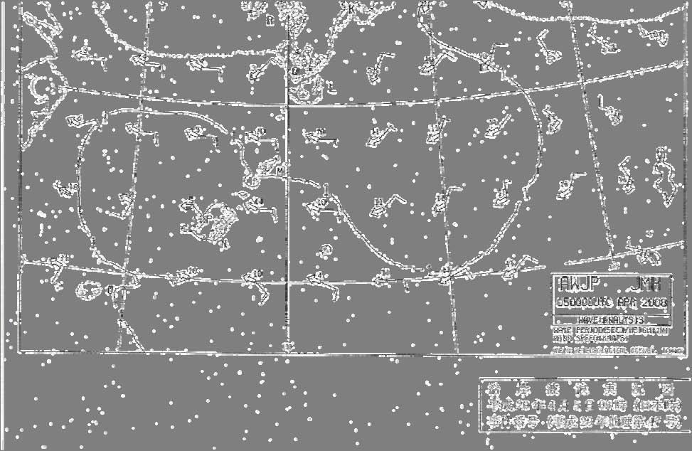
22 Figure 1 Kugurizaka Fishing Port, the Fishing Grounds of Ship A and its Consort Ships, and the Discovery Location of the Sunken Ship A (outline map) Extent of scallop farm Boat F Fishing Ground Boat B Fishing Gournd Yunoshima Boat C Fishing Ground Boat A Fishing Ground Boat E Fishing Ground Wind speed 5-13 m/s (according to oral reports and Coast Guard Office materials) Wave height 1-3 m (according to oral reports) Boat D Fishing Ground Site where Boat A Discovered Kugurizaka Port Western Breakwater Lighthouse Hanaguri Saki Location of this accident km M 20


 Pearl nets Round lantern")
 ABS buoys")
23 Figure 2 Standard Scallop Farm Sea surface Float Adjustment buoy Adjustment buoy Adjustment buoy Adjustment buoy Adjustment buoy ABS buoy ABS buoy ABS buoy ABS buoy Midwater buoy Adjustment line ABS buoy Buoy gangion Branch line Mainline Mainline Branch line Branch line Branch line 21 Spat bags Weight line Ear hanging (in pairs) Pearl nets Round lantern nets Chain Sinker Stone weight Metal sinker Sea bed Round lantern nets Diameter: 50cm Anchor Anchor Note) ABS buoys refers to synthetic plastic buoys.


24 Figure 3 General Arrangement of Ship A (outline plan) Storage Hatch wheelhouse Engine casing Fish hold hatch Engine room Fish hold 22 Rudder box Fish hold hatch Storage Engine room Fish hold


 23")
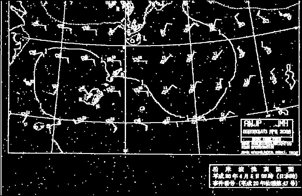
25 Figure 4 Coastal Wave Analysis Chart (as of 09:00 on April 5th) 23
26 Figure 5 Discovery Locations of Crew Members (outline map) Futago Island Kojima 17:40, July 22: 1 person Shigeura Port Western Breakwater Lighthouse Shigeura Island Kamome Island 06:35, April 5: 1 body 17:10, May 24: 1 body 16:30, April 7: 3 bodies 16:50, April 6: 1 body 15:40, April 7: 1 body (Where Boat A was discovered) Kugurizaka Port Western Breakwater Lighthouse km M 24


 (1)")


27 Figure 6 Cross Curves of Stability for Ship A Created by its Manufacturer Graphed calculated values Displacement KG (center of gravity height) (1) Normal state 9.55t 0.83m (2) State t 0.93m (3) State t 0.97m (4) State t 1.04m (5) State t 1.12m Angle of heel Displacement (ton) 25
28 Figure 7 NMRI Analysis Results Regarding Stability at the Time of Leaving Port and the Time of the Accident (outline) 1. Calculation Conditions (1) State at time of leaving port 1) Crew There were eight crew members at the time of leaving port, and their combined weight was used as the weight of the crew. Additionally, at the time of leaving port, it is assumed that Captain A stood in the wheelhouse and the other crew members were standing on the deck aft of the wheelhouse. The center of gravity of the crew was taken to be 1/2 of their height. 2) Fuel The fuel consumption was 1/3 of a full tank (800 l) 3) Crane The weight of the crane was taken to be t. It was in a stowed state when the ship left port. (2) State at the time of the accident 1) Catch (baskets (pearl nets) with scallops in them) The weight of the catch was 4.5 t, and it was piled on the deck forward of the wheelhouse. The height of the catch was assumed using three different states: 1.5 m (Accident State 1), 1.75 m (Accident State 2), and 2.0 m (Accident State 3). The average draught due to the loaded catch was deeper by 0.16m (0.41 m when leaving port and 0.57 m when the accident occurred). 2) Crane At the time of the accident, the crane was extended out 7.2 m, and swung out 45 degrees to port and 43 degrees upwards. The state when the crane was stowed and the catch was piled to a 1.5 m height was also assumed for comparison purposes (Accident State 4). 2. Righting lever curves (Calculated Results) Righting lever 復原力曲線 curves 事故発生時 Accident State 1 状態 1 (B.W. (B.W. top) top) Ditto (U.D.) (U.D.) 事故発生時 Accident State 2 状態 2 (B.W. (B.W. top) top) Ditto (U.D.) (U.D.) 事故発生時 Accident State 3 状態 3 (B.W. (B.W. top) top) Ditto (U.D.) (U.D.) 事故発生時 Accident State 4 状態 4 (B.W. (B.W. top) top) Ditto (U.D.) (U.D.) 出港時 When (B.W. leaving top) port Ditto (U.D.) (U.D.) GZ (m) φ(deg.) NB) The solid lines (B.W. top) mean that GZ is calculated as the buoyancy extent included up to the top edge of the bulwarks. The broken lines (U.D.) mean that GZ is calculated as the buoyancy extent included up to the deck. The horizontal axis is the angle of heel, and the vertical axis is the righting lever. 26
29 3. Resonant Roll due to Beam Waves (Calculated Results) Bulwark Top Edge Submergence Angle (deg.) Natural Roll Period (s) Resonant Roll Angle (deg.) Wind Wind Velocity Velocity 10 m/s 13 m/s Wave Length in Resonant Roll (m) Wave Height (m) Wind Velocity 10 m/s Wind Velocity 13 m/s Accident State Accident State Accident State Accident State Leaving Port NB) The resonant roll angle is calculated taking into consideration irregular waves. Wave length and height are values adjusted to an appropriate regular wave. 4. Capsizing Due to External Forces During Resonant Roll (Calculated Results) (1) Accident Scenario 1 (Load Collapse) With a large angle of heel (approx. 26 degrees) that would submerge the top edge of the bulwarks, the catch would collapse and shift laterally to the sides of the vessel. Steady heel angle due to catch movement φ n (deg.) Accident State 1 Accident State 2 Accident State 3 Accident State 4 Movement distance of center of gravity for Capsizing 12.5 Catch, lf (m) Capsizing Capsizing 14.1 NB) The vessel will capsize when the heeling moment caused by the shift in the center of gravity is greater than the maximum stability righting moment. (The steady heel angles when the stability and heeling moment balance out are not calculated.) (2) Accident Scenario 2 (Human Movement) The crew members other than Captain A, in the wheelhouse, lose their balance due to the rolling at the time of the accident, and move in the direction of the rolling. (This considers the acceleration laterally in line with a roll angle of 26 degrees and a natural roll period of approx. 3 seconds.) Dynamic Stability / Roll energy following crew movement Accident State 1 Accident State 2 Accident State 3 Accident State 4 Leaving Port Movement distance of center of gravity for Crew, lf (m) NB) When the roll energy (the work amount needed to capsize the vessel) is greater than the dynamic stability (the work amount needed for stabilization) following the movement, the vessel will capsize. 27
30 (3) Accident Scenario 3 (Beam Wind) The vessel is hit by a beam wave / beam winds while resonant roll. (The direction strength is added by considering the temporally changing north-west south-west wind and waves from the west.) Coefficient C (b/a) Wind Velocity Vw (m/s) Accident State 1 Accident State 2 Accident State 3 Accident State 4 Leaving Port NB) When the roll energy (the work amount needed to capsize, a) is greater than the dynamic stability when the vessel is hit by a lateral wind (the work amount needed for stabilization, b), the vessel will capsize. 28


31 Photo 1 Ship A After Refloated Bulwark Stanchion 29
MA MARINE ACCIDENT INVESTIGATION REPORT
 MA2014-2 MARINE ACCIDENT INVESTIGATION REPORT February 28, 2014 The objective of the investigation conducted by the Japan Transport Safety Board in accordance with the Act for Establishment of the Japan
MA MARINE ACCIDENT INVESTIGATION REPORT
 MA2013-4 MARINE ACCIDENT INVESTIGATION REPORT April 26, 2013 The objective of the investigation conducted by the Japan Transport Safety Board in accordance with the Act for Establishment of the Japan Transport
MARINE ACCIDENT INVESTIGATION REPORT
 MA2013-10 MARINE ACCIDENT INVESTIGATION REPORT October 25, 2013 Japan Transport Safety Board The objective of the investigation conducted by the Japan Transport Safety Board in accordance with the Act
MARINE ACCIDENT INVESTIGATION REPORT
 MARINE ACCIDENT INVESTIGATION REPORT December 8th,2016 Adopted by the Japan Transport Safety Board Member Kuniaki Shoji Member Satoshi Kosuda Member Mina Nemoto Accident Type Contact (light buoy) Date
An Investigation into the Capsizing Accident of a Pusher Tug Boat
 An Investigation into the Capsizing Accident of a Pusher Tug Boat Harukuni Taguchi, National Maritime Research Institute (NMRI) taguchi@nmri.go.jp Tomihiro Haraguchi, National Maritime Research Institute
A STUDY ON FACTORS RELATED TO THE CAPSIZING ACCIDENT OF A FISHING VESSEL RYUHO MARU No.5
 8 th International Conference on 49 A STUDY ON FACTORS RELATED TO THE CAPSIZING ACCIDENT OF A FISHING VESSEL RYUHO MARU No.5 Harukuni Taguchi, Shigesuke Ishida, Iwao Watanabe, Hiroshi Sawada, Masaru Tsujimoto,
Class B Accident Report. Melilla 201 Man Overboard
 Class B Accident Report Melilla 201 Man Overboard 96 Nautical Miles south of Stewart Island on 19 November 2004 REPORT NO: 04 3607 MELILLA 201 MAN OVERBOARD FATALITY At 0545 hours New Zealand Standard
Report on Vessel Casualty of Accident (Form Casualty) Instructions:
 Instructions:") Report on Vessel Casualty of Accident (Form Casualty) Tuvalu Ship Registry 10 Anson Road #25-16 International Plaza Singapore 079903 Tel: (65) 6224 2345 Fax: (65) 6227 2345 Email: info@tvship.com Website:
Report on Vessel Casualty of Accident (Form Casualty) Tuvalu Ship Registry 10 Anson Road #25-16 International Plaza Singapore 079903 Tel: (65) 6224 2345 Fax: (65) 6227 2345 Email: info@tvship.com Website:
Marine Kit 4 Marine Kit 4 Sail Smooth, Sail Safe
 Marine Kit 4 Marine Kit 4 Sail Smooth, Sail Safe Includes Basic ship Terminologies and Investigation Check list Index 1. Ship Terminology 03 2. Motions of a Floating Body...09 3. Ship Stability.10 4. Free
RESOLUTION MSC.235(82) (adopted on 1 December 2006) ADOPTION OF THE GUIDELINES FOR THE DESIGN AND CONSTRUCTION OF OFFSHORE SUPPLY VESSELS, 2006
 (adopted on 1 December 2006) ADOPTION OF THE GUIDELINES FOR THE DESIGN AND CONSTRUCTION OF OFFSHORE SUPPLY VESSELS, 2006") MSC 82/24/Add.2 RESOLUTION MSC.235(82) CONSTRUCTION OF OFFSHORE SUPPLY VESSELS, 2006 THE MARITIME SAFETY COMMITTEE, RECALLING Article 28(b) of the Convention on the International Maritime Organization
MSC 82/24/Add.2 RESOLUTION MSC.235(82) CONSTRUCTION OF OFFSHORE SUPPLY VESSELS, 2006 THE MARITIME SAFETY COMMITTEE, RECALLING Article 28(b) of the Convention on the International Maritime Organization
GUIDANCE NOTICE. Unpowered Barges. Definition. General. Risk assessment. Application. Safety Management. Compliance
 GUIDANCE NOTICE Unpowered Barges Definition Unpowered Barge - a vessel that is not propelled by mechanical means and is navigated by a powered vessel that moves it by pushing or towing. General This notice
FREE SURFACE EFFECTS. Partially-filled (slack) tanks can be dangerous; the number of slack tanks should be kept to a minimum.
 tanks can be dangerous; the number of slack tanks should be kept to a minimum.") 26 FREE SURFACE EFFECTS Care should always be taken to ensure the quick release of water trapped on deck. Locking freeing port covers is dangerous. If locking devices are fitted, the opening mechanism
26 FREE SURFACE EFFECTS Care should always be taken to ensure the quick release of water trapped on deck. Locking freeing port covers is dangerous. If locking devices are fitted, the opening mechanism
properly applied assessment in the use.1 landmarks.1 approved in-service of ECDIS is not experience The primary method of fixing required for those
 STCW Code Table A-II/3 Specification of minimum standard of for officers in charge of a navigational watch and for masters on ships of less than 500 gross tonnage engaged on near-coastal voyages Ref: https://www.edumaritime.net/stcw-code
Safety practices related to small fishing vessel stability
 18 The vessel s centre of gravity (G) has a distinct effect on the righting lever (GZ) and consequently the ability of a vessel to return to the upright position. The lower the centre of gravity (G), the
AA AIRCRAFT ACCIDENT INVESTIGATION REPORT. Setouchi SEAPLANES Inc. J A 0 2 T G
 AA2018-2 AIRCRAFT ACCIDENT INVESTIGATION REPORT Setouchi SEAPLANES Inc. J A 0 2 T G February 22, 2018 The objective of the investigation conducted by the Japan Transport Safety Board in accordance with
AIRCRAFT ACCIDENT INVESTIGATION REPORT
 AA2018-1 AIRCRAFT ACCIDENT INVESTIGATION REPORT PRIVATELY OWNED J A 0 0 7 P January 25, 2018-0 - The objective of the investigation conducted by the Japan Transport Safety Board in accordance with the
CHAPTER 6 OFFSHORE OPERATIONS
 CHAPTER 6 OFFSHORE OPERATIONS I. GENERAL It is very important that all personnel who will be working offshore be thoroughly familiar with the provisions of this section of the Company's. All rules and
Fishing Vessel Stability
 Fishing Vessel Stability Or How To Stay Upright Fishing Vessel Stability What It Is? How Does It Work? What is Adequate Stability? What Happens During Typical Fishing Operations? 1 What is Stability? Stability
MA MARINE ACCIDENT INVESTIGATION REPORT
 MA2013-5 MARINE ACCIDENT INVESTIGATION REPORT May 31, 2013 The objective of the investigation conducted by the Japan Transport Safety Board in accordance with the Act for Establishment of the Japan Transport
1.0 PURPOSE AND NEED
 1.0 PURPOSE AND NEED 1.0 PURPOSE OF AND NEED FOR THE PROPOSED ACTION 1.1 INTRODUCTION The National Environmental Policy Act (NEPA) of 1969, as amended (42 United States Code Section 4321 et seq.); the
Enhanced Discussion of Requirements for Commercial Fishing Vessels
 Update on U.S. Commercial Fishing Industry Vessel Requirements Based On Section 604 of the Coast Guard Authorization Act of 2010 (Public Law 111-281) And Section 305 of the Coast Guard and Maritime Transportation
Working Near, On or Above Water
 APPROVALS Position Name Date President Donna Stobbart DISCLAIMER: City Transfer nor any person acting on its behalf, makes any warranty, express or implicit, with respect to the use of information, data,
To: Relevant departments of CCS Headquarters, Plan approval centers, CCS surveyors, relevant shipyards, designers and shipping companies
 Form: RWPRR401-B CCS Circular China Classification Society (2012) Circ. No. 14 Total No.176 January 29, 2012 (Total pages: 1+5 ) To: Relevant departments of CCS Headquarters, Plan approval centers, CCS
Interim Investigation Report pertaining to the investigation report 71/17. Very Serious Marine Casualty
 Federal Higher Authority subordinated to the Ministry of Transport and Digital Infrastructure Interim Investigation Report pertaining to the investigation report 71/17 Very Serious Marine Casualty Collision
RULES AND PROCEDURES OF THE FARALLON PATROL V5 April 2014
 Introduction RULES AND PROCEDURES OF THE FARALLON PATROL V5 April 2014 The Farallon Patrol has a long and distinguished record of service to Point Blue Conservation Science and its staff members who conduct
New Requirements for Commercial Fishing Industry Vessels Section 604 Coast Guard Authorization Act of 2010 (Public Law )
") New Requirements for Commercial Fishing Industry Vessels Section 604 Coast Guard Authorization Act of 2010 (Public Law 111-281) On October 15, 2010, the President signed the law that included provisions
New Requirements for Commercial Fishing Industry Vessels Section 604 Coast Guard Authorization Act of 2010 (Public Law 111-281) On October 15, 2010, the President signed the law that included provisions
Accident Report. San Constanzo Flooding approximately 35 miles east of Gisborne on 18 January 2004
 Accident Report San Constanzo Flooding approximately 35 miles east of Gisborne on 18 January 2004 SUMMARY Leaking seams in the vessel s wooden hull, allowed water to enter the vessel and flood the forward
SHIP SAFETY BULLETIN. Subject: Bulletin No.: 06/2012 RDIMS No.: Date: Y - M - D
 TP 3231 E SHIP SAFETY BULLETIN Bulletin No.: 06/2012 RDIMS No.: 7806082 Date: 2012-10-04 Y - M - D We issue Ship Safety Bulletins for the marine community. Visit our Website at www.tc.gc.ca/ssb-bsn to
MA MARINE ACCIDENT INVESTIGATION REPORT
 MA2016-10 MARINE ACCIDENT INVESTIGATION REPORT October 27, 2016 The objective of the investigation conducted by the Japan Transport Safety Board in accordance with the Act for Establishment of the Japan
International regulations and guidelines for maritime spatial planning related to safe distances to multiple offshore structures (e.g.
 International regulations and guidelines for maritime spatial planning related to safe distances to multiple offshore structures (e.g. wind farms) Introduction This is a summary of the most important international
OPERATIONS SEAFARER CERTIFICATION GUIDANCE NOTE SA MARITIME QUALIFICATIONS CODE
 Page 1 of 8 Compiled by Chief Examiner Approved by Qualifications Committee: 27 September 2013 OPERATIONS SEAFARER CERTIFICATION GUIDANCE NOTE SA MARITIME QUALIFICATIONS CODE Page 2 of 8 KNOWLEDGE, UNDERSTANDING
Marine Transportation Safety Investigation Report M18P0073
 Marine Transportation Safety Investigation Report M18P0073 SINKING AND LOSS OF LIFE Fishing vessel Western Commander Triple Islands, Dixon Entrance, British Columbia 09 April 2018 About the investigation
Commonwealth of Dominica. Office of the Maritime Administrator
 Commonwealth of Dominica Office of the Maritime Administrator TO: ALL SHIPOWNERS, OPERATORS, MASTERS, AND SEAFARERS OF MERCHANT SHIPS, AND RECOGNIZED ORGANIZATIONS SUBJECT: REFERENCE: EMERGENCY TRAINING
SHIP DESIGN AND EQUIPMENT
 E MARITIME SAFETY COMMITTEE 92nd session Agenda item 13 MSC 92/INF.7 5 April 2013 ENGLISH ONLY SHIP DESIGN AND EQUIPMENT Sample form for ship-specific plans and procedures for recovery of persons from
Incident Report. Close Quarters Pegasus II & Distraction. 26 April 2006 Class B
 Incident Report Close Quarters Pegasus II & Distraction 26 April 2006 Class B NARRATIVE Pegasus II (See Photograph 1 Pegasus II) is a 15.46 metre commercial fishing vessel with a gross tonnage of 40. She
INTERIM REPORT INTO THE FATAL INCIDENT ON-BOARD FV CU NA MARA APPROXIMATELY 130 NAUTICAL MILES WEST OF SLEA HEAD ON 30th JUNE 2016.
 INTERIM REPORT INTO THE FATAL INCIDENT ON-BOARD FV CU NA MARA APPROXIMATELY 130 NAUTICAL MILES WEST OF SLEA HEAD ON 30th JUNE 2016. REPORT NO. MCIB/261/INTERIM (No.5 OF 2017) The Marine Casualty Investigation
Remarks by Chief Commissioner John Marshall QC
 Marine inquiry 12-201 Fishing vessel Easy Rider, capsize and foundering, Foveaux Strait, 15 March 2012 Remarks by Chief Commissioner John Marshall QC 1. I would like to begin by acknowledging the eight
National Maritime Center
 National Maritime Center Providing Credentials to Mariners (Sample Examination) Page 1 of 8 Choose the best answer to the following Multiple Choice Questions. 1. Which term indicates the rise in height
RYA MAJOR YOUTH & JUNIOR EVENT SAFETY STANDARD OPERATING POLICY AND PROCEDURES
 RYA MAJOR YOUTH & JUNIOR EVENT SAFETY STANDARD OPERATING POLICY AND PROCEDURES Index: 1. Introduction 2. Objectives 3. Overall organisational structure 4. Radio callsigns 5. Radio procedures 6. Safety
REGULATION on life boats operated from land, No 123/1999 CHAPTER I. General provisions Article 1
 REGULATION on life boats operated from land, No 123/1999 CHAPTER I General provisions Article 1 Scope These rules apply to lifeboats, the construction of which has begun or which have arrived in the country
Demonstrate basic knowledge of the operation of pleasure/small craft by day
 Page 1 of 7 Title Demonstrate basic knowledge of the operation of pleasure/small craft by day Level 2 Credits 6 Purpose This unit standard is for pleasure craft operators and covers knowledge required
GUIDELINES FOR NAVIGATION UNDER THE CONFEDERATION BRIDGE
 (12/2009) GUIDELINES FOR NAVIGATION UNDER THE CONFEDERATION BRIDGE REVISION 1 DECEMBER 2009 Responsible Authority The Regional Director Marine Safety Atlantic Region is responsible for this document, including
ANCHORING REQUIREMENTS FOR LARGE CONTAINER SHIPS
 ANCHORING REQUIREMENTS FOR LARGE CONTAINER SHIPS 1 INTRODUCTION 1.1 Background Some modern container ships are larger than most of the existing fleet, whose experience has been used as the basis of classification
Note to Shipbuilders, shipowners, ship Managers and Masters. Summary
 MARINE GUIDANCE NOTE MGN 301 (M+F) Manoeuvring Information on Board Ships Note to Shipbuilders, shipowners, ship Managers and Masters This note supersedes Marine Guidance Note MGN 201 (M+F) Summary The
EQUIPMENT AND PERSONNEL
 1 EQUIPMENT AND PERSONNEL Inland Rivers and Gulf Coast 2013 Section 4 Topics 4.1 Equipment Boats 4.1.1 Types and Sizes of Towboats 4.1.2 Main Propulsion Equipment 4.2 Equipment Barges 4.2.1 Barge Sizes,
ISAF OFFSHORE SPECIAL REGULATIONS Appendix J
 Page - 95 - APPENDIX J CATEGORY 5 SPECIAL REGULATIONS for inshore races Category 5 Special Regulations are intended for use in short races, close to shore in relatively warm and protected waters where
MARINE INVESTIGATION REPORT M10M0014 CAPSIZING AND SINKING
 MARINE INVESTIGATION REPORT M10M0014 CAPSIZING AND SINKING SMALL FISHING VESSEL CRAIG AND JUSTIN OFF MARGAREE HARBOUR, NOVA SCOTIA 01 MAY 2010 The Transportation Safety Board of Canada (TSB) investigated
MARINE CIRCULAR MC-25/2012/1
 Singapore Operations Office: 10 Anson Road #25-16, International Plaza, Singapore 079903 Tel: (65) 6224 2345 Fax: (65) 6227 2345 Email: info@tvship.com Website: www.tvship.com 4/2013 MARINE CIRCULAR MC-25/2012/1
ADMINISTRATIVE INSTRUCTION No. STCW-14 QUALIFICATION / CERTIFICATION REQUIRED FOR OPERATION OF A DOMESTIC VESSESL
 ADMINISTRATIVE INSTRUCTION No. STCW-14 QUALIFICATION / CERTIFICATION REQUIRED FOR OPERATION OF A DOMESTIC VESSESL (Issued under section 3(5) of the Gibraltar Merchant Shipping (Safety etc.) Ordinance 1993
Rule Change Notice For: RULES FOR CLASSIFICATION OF MOBILE OFFSHORE UNITS
 CHINA CLASSIFICATION SOCIETY Rule Change Notice For: RULES FOR CLASSIFICATION OF MOBILE OFFSHORE UNITS Version: December, 2016,RCN No.2 Effective date: 03 January, 2017 Beijing Contents PART ONE PROVISIONS
Stability Information Booklet. Priority Pontoon
 Stability Information Booklet Priority Pontoon Lightship Index General Particulars...3 General Details...4 Plan - GA...5 Plan - Frames...6 General Precautions against capsizing...7 Special Notes Regarding
DALGETY BAY SAILING CLUB RIB SAFETY BOAT RISK ASSESSMENT
 1 INTRODUCTION This safety protocol addresses the assessment of risks associated with use of RIB Safety Botas as part of any dinghy racing event. Some risks are inherent to boating, sailing and racing,
A guide to. fishing vessel stability
 A guide to fishing vessel stability 2017 This work has been republished with the permission of Maritime New Zealand. Contents Introduction 2 1. The importance of stability 2 The basics of stability: buoyancy
AI AIRCRAFT SERIOUS INCIDENT INVESTIGATION REPORT AERO ASAHI CORPORATION J A
 AI2017-3 AIRCRAFT SERIOUS INCIDENT INVESTIGATION REPORT AERO ASAHI CORPORATION J A 9 6 7 8 July 27, 2017 The objective of the investigation conducted by the Japan Transport Safety Board in accordance with
Investigation of the Intact Stability Accident of the Multipurpose Vessel MS ROSEBURG
 Proceedings of the 12th International Conference on the Stability of Investigation of the Intact Stability Accident of the Multipurpose Vessel MS ROSEBURG Adele Lübcke, Institute of Ship Design and Ship
Solway Harvester BA794
 Investigation of the capsize and sinking of the fishing vessel Solway Harvester BA794 11 miles east of the Isle of Man on 11 January 2000 with the loss of seven lives Marine Accident Investigation Branch
Foundering of the fishing vessel CONDOR on 6 February 2016 approx. 3.5 nm east of the Baltic island of Fehmarn
 Federal Higher Authority subordinated to the Ministry of Transport and Digital Infrastructure Interim Investigation Report pertaining to Investigation Report 44/16 Very Serious Marine Casualty Foundering
STABILITY OF MULTIHULLS Author: Jean Sans
 STABILITY OF MULTIHULLS Author: Jean Sans (Translation of a paper dated 10/05/2006 by Simon Forbes) Introduction: The capsize of Multihulls requires a more exhaustive analysis than monohulls, even those
SLSA Policy Statement Water Safety
 SLSA Circular SLSA Policy Statement 1.1 Water Safety No: 12/2011 12 To: From: SLS Clubs and Services SLS Branches SLS States/Territory Surf Life Saving Australia Date: 25/07/2011 Subject: SLSA Policy Statement
MARINE INVESTIGATION REPORT M08C0058 CAPSIZING AND SUBSEQUENT SINKING
 MARINE INVESTIGATION REPORT M08C0058 CAPSIZING AND SUBSEQUENT SINKING WORKBOAT BONNIE MOUSE OFFF GEORGE ISLAND, LAKE WINNIPEG, MANITOBA 21 OCTOBER 2008 The Transportation Safety Board of Canada (TSB) investigated
Chapter 1 Boat systems
 Chapter 1 Boat systems Hulls Two common types of boating hulls, displacement and planing, are shown in Figure 5.1. A displacement hull is a type of hull that ploughs through the water, displacing a weight
MSC Guidelines for Review of Stability for Sailing Catamaran Small Passenger Vessels (T)
") K.B. FERRIE, CDR, Chief, Hull Division References: a. 46 CFR Subchapter T, Parts 178, 179 b. 46 CFR Subchapter S, Parts 170, 171 c. Marine Safety Manual (MSM), Vol. IV d. Navigation and Vessel Circular
K.B. FERRIE, CDR, Chief, Hull Division References: a. 46 CFR Subchapter T, Parts 178, 179 b. 46 CFR Subchapter S, Parts 170, 171 c. Marine Safety Manual (MSM), Vol. IV d. Navigation and Vessel Circular
BC Sailing Safety at Sea CYA-ISAF Approved Offshore Personal Survival Course Syllabus a
 BC Sailing Safety at Sea CYA-ISAF Approved Offshore Personal Survival Course Syllabus 2011-03-03a This course syllabus follows, with modifications, the ISAF Offshore Special Regulations, Appendix G Model
Ship Stability. Ch. 8 Curves of Stability and Stability Criteria. Spring Myung-Il Roh
 Lecture Note of Naval Architectural Calculation Ship Stability Ch. 8 Curves of Stability and Stability Criteria Spring 2016 Myung-Il Roh Department of Naval Architecture and Ocean Engineering Seoul National
GUIDELINES ON OPERATIONAL INFORMATION FOR MASTERS IN CASE OF FLOODING FOR PASSENGER SHIPS CONSTRUCTED BEFORE 1 JANUARY 2014 *
 E 4 ALBERT EMBANKMENT LONDON SE1 7SR Telephone: +44 (0)20 7735 7611 Fax: +44 (0)20 7587 3210 MSC.1/Circ.1589 24 May 2018 GUIDELINES ON OPERATIONAL INFORMATION FOR MASTERS IN CASE OF FLOODING FOR PASSENGER
National Maritime Center
 National Maritime Center Providing Credentials to Mariners (Sample Examination) Page 1 of 8 Choose the best answer to the following Multiple Choice questions. 1. On 1 September your 1115 zone time DR position
MA MARINE ACCIDENT INVESTIGATION REPORT
 MA2013-1 MARINE ACCIDENT INVESTIGATION REPORT January 25, 2013 The objective of the investigation conducted by the Japan Transport Safety Board in accordance with the Act for Establishment of the Japan
APPENDIX IV DEVELOPMENT AND MEASUREMENT RULES OF THE INTERNATIONAL TEN SQUARE METER SAILING CANOE
 APPENDIX IV Development Canoe Rules APPENDIX IV DEVELOPMENT AND MEASUREMENT RULES OF THE INTERNATIONAL TEN SQUARE METER SAILING CANOE 1 GENERAL Class and measurement rules measurement forms may be obtained
Simplified report of safety investigation
 Simplified report of safety investigation COLLISION BETWEEN SALVATORE CAFIERO AND NAUSICAA ON 22 APRIL 2012 IN THE WESTERN APPROACHES TO THE ENGLISH CHANNEL Report published on : July 2013 2 COLLISION
ANNEX 5 IMO MARINE CASULATY AND INCIDENT REPORT DAMAGE CARDS* AND INTACT STABILITY CASUALTY RECORDS
 ANNEX 5 IMO MARINE CASUATY AND INCIDENT REPORT DAMAGE CARDS* AND INTACT STABIITY CASUATY RECORDS Statistics of damaged ships and of intact stability casualties are important to the work of the Organization
LESSONS LEARNED FROM MARINE CASUALTIES. Very serious marine casualty: tug master struck by a falling stores container
 LESSONS LEARNED FROM MARINE CASUALTIES 1 FATALITY Very serious marine casualty: tug master struck by a falling stores container While discharging a routine parcel of crude oil alongside an oil terminal,
This lesson will be confined to the special case of ships at rest in still water. Questions of motions resulting from waves are not considered at
 STATIC STABILITY When we say a boat is stable we mean it will (a) float upright when at rest in still water and (b) return to its initial upright position if given a slight, temporary deflection to either
GOSPORT REGATTA 2018
 GOSPORT REGATTA 2018 A Sail Race Sponsored by Star Island Corporation Sunday, September 16th Sailing Instructions 1. Rules: The regatta is organized by the PSA Race Committee on behalf of the Star Island
July 1, 2011 No. 12/2011
 July 1, 2011 No. 12/2011 Safety alert Applicability Information Overweight rescue boat Norsafe Watercraft Hellas WHFRB 6.50 (MAIB Safety Bulletin 1/2011) Shipowners and managers Following the recent failure
National Maritime Center
 National Maritime Center Providing Credentials to Mariners Master TV to Master Less than 500 Gross Registered Tons Oceans or Near Coastal (Sample Examination) Page 1 of 6 Master TV to Master Less than
Summary Report. Grounding Twofold Bay. 20 July 2006
 Summary Report Grounding Twofold Bay 20 July 2006 NARRATIVE On the evening of 19 July 2006, the Skipper of Twofold Bay brought the vessel into Whangawehi Roads on the north coast of the Mahia Peninsula
REPORT INTO THE SINKING OF FV LADY EILEEN ON 13th AUGUST 2012
 Leeson Lane, Dublin 2. Telephone: 01-678 3485/86. Fax: 01-678 3493. email: info@mcib.ie www.mcib.ie REPORT INTO THE SINKING OF FV LADY EILEEN ON 13th AUGUST 2012 The Marine Casualty Investigation Board
OFFSHORE PATROL VESSEL OPERATIONS
 Florida Fish and Wildlife Conservation Commission Division of Law Enforcement OFFSHORE PTROL VESSEL OPERTIONS GENERL ORDER EFFECTIVE DTE RESCINDS/MENDS PPLICBILITY 30 May 7, 2018 July 21, 2008 ll Sworn
BASIC SAFETY GUIDANCE FOR YACHT RACES OR OCEANIC VOYAGES BY NON-REGULATED CRAFT
 E 4 ALBERT EMBANKMENT LONDON SE1 7SR Telephone: +44 (0)20 7735 7611 Fax: +44 (0)20 7587 3210 BASIC SAFETY GUIDANCE FOR YACHT RACES OR OCEANIC VOYAGES BY NON-REGULATED CRAFT MSC.1/Circ.1413 25 May 2012
DALGETY BAY SAILING CLUB RYA RTC RISK ASSESSMENT
 This Risk Assessment is intended to cover routine training sessions at DBSC, involving the club s fleet of training boats. Responsibility: The overall responsibility for R.Y.A. Training is vested in Dalgety
SAFETY OF NAVIGATION STANDARDS IN THE PORTS OF NAUTICAL TOURISM WITH A SPECIAL FOCUS ON THE MAINTENANCE OF THE PORT ORDER
 SAFETY OF NAVIGATION STANDARDS IN THE PORTS OF NAUTICAL TOURISM WITH A SPECIAL FOCUS ON THE MAINTENANCE OF THE PORT ORDER Ranka Petrinović, Ph. D, Full Professor Nikola Mandić, Ph. D, Assistant Professor
National Maritime Center
 National Maritime Center Providing Credentials to Mariners (Sample Examination) Page 1 of 12 Choose the best answer to the following Multiple Choice Questions. 1. What class of bulkhead is required around
E R I K A O c c u p a t i o n a l A c c i d e n t F a l l O v e r b o a r d 2 7 F e b r u a r y
 MARINE ACCIDENT REPORT Danish Maritime Accident Investigation Board E R I K A O c c u p a t i o n a l A c c i d e n t F a l l O v e r b o a r d 2 7 F e b r u a r y 2 0 1 1 Page 1 of 19 Danish Maritime
SECOND ENGINEER REG III/2 NAVAL ARCHITECTURE
 SECOND ENGINEER REG III/2 NAVAL ARCHITECTURE LIST OF TOPICS A B C D E F G H I J Hydrostatics Simpson's Rule Ship Stability Ship Resistance Admiralty Coefficients Fuel Consumption Ship Terminology Ship
TECHNICAL REPORT A-061/2003 DATA SUMMARY
 TECHNICAL REPORT A-061/2003 DATA SUMMARY LOCATION Date and time Site Wednesday, 24th Sept. 2003; 13:20 h local time 1 NM to the south of Porto Petro (Balearic Islands) AIRCRAFT Registration Type and model
TOWING OFFICER ASSESSMENT RECORD
 TOWING OFFICER ASSESSMENT RECORD NEAR COASTAL / OCEANS SIGNATED EXAMINER INFORMATION All Designated Examiners (s) signing off successful completion of practical assessments should provide the information
Towing support tool and object drift at sea
 Towing support tool and object drift at sea Nakhodka National Maritime Research Institute Shoichi Hara (presented by Michel Olagnon) Research background Nakhodka oil leakage incident (Jan. 1997) Erika
830.8 Interpretations No.1 8-1
 . 830.8 Interpretations No.1 8-1 Interpretation: 8.1 ANSI/ASME B30.8-1982 Date Issued: August 4, 1987 Question: What is the meaning of "blocked and anchored" as it relates to land cranes mounted on a barge
The Icelandic Information System on Weather and Sea State Related to Fishing Vessels Crews and Stability
 The Icelandic Information System on Weather and Sea State Related to Fishing Vessels Crews and Stability Seminar on Fishing Vessels Crews and Stability World Fishing Exhibition 2009, Vigo Spain September
MARINE ACCIDENT INVESTIGATION REPORT
 MA2010-5 MARINE ACCIDENT INVESTIGATION REPORT May 28, 2010 Japan Transport Safety Board The objective of the investigation conducted by the Japan Transport Safety Board in accordance with the Act for Establishment
4 th Annual Nadadores 2.4 Mile Rough Water Swim
 4 th Annual Nadadores 2.4 Mile Rough Water Swim Salt Creek Beach in Dana Point, CA Saturday, May 16, 2015 EVENT SAFETY OPERATIONS: OC Lifeguards (OCLG) will manage water safety operations for the swim
MSC Guidelines for Review of Stability for Towing Vessels (M)
") S. E. HEMANN, CDR, Chief, Hull Division References Contact Information a. 46 CFR Subchapter M, Part 144 b. 46 CFR Subchapter S, Parts 170, 173 c. Navigation and Vessel Circular No. 17-91, CH 1, Guidelines
S. E. HEMANN, CDR, Chief, Hull Division References Contact Information a. 46 CFR Subchapter M, Part 144 b. 46 CFR Subchapter S, Parts 170, 173 c. Navigation and Vessel Circular No. 17-91, CH 1, Guidelines
The Sarasota Yacht Club F18 World Championship 2018
 The Sarasota Yacht Club F18 World Championship 2018 Organizing Authority - F18 International Class Hosted by Sarasota Sailing Squadron In all sections the following abbreviations apply: [DP] denotes a
REPORT OF THE INVESTIGATION INTO THE CAPSIZING OF THE NA BUACHAILLÍ ON 18th FEBRUARY 2011.
 Leeson Lane, Dublin 2. Telephone: 01-678 3485/86. Fax: 01-678 3493. email: info@mcib.ie www.mcib.ie REPORT OF THE INVESTIGATION INTO THE CAPSIZING OF THE NA BUACHAILLÍ ON 18th FEBRUARY 2011. The Marine
RULES FOR THE CONSTRUCTION AND CLASSIFICATION OF SHIPS IDENTIFIED BY THEIR MISSIONS CHAPTERS SCOPE
 PART II RULES FOR THE CONSTRUCTION AND CLASSIFICATION OF SHIPS IDENTIFIED BY THEIR MISSIONS TITLE 12 CONTAINER SHIPS SECTION 1 NAVAL ARCHITECTURE CHAPTERS A SCOPE B DOCUMENTS, REGULATIONS AND STANDARDS
.3 the correct operation of the communications medium between the navigation bridge and the steering gear compartment.
 221-389.2 a visual inspection of the steering gear and its associated links; and.3 the correct operation of the communications medium between the navigation bridge and the steering gear compartment. 3.1
REPORT OF INVESTIGATION INTO THE CAPSIZE OF THE BARBARA MARY AT KILKEE BAY, CO. CLARE ON 18th SEPTEMBER 2008
 Leeson Lane, Dublin 2. Telephone: 01-678 3485/86. Fax: 01-678 3493. email: info@mcib.ie www.mcib.ie REPORT OF INVESTIGATION INTO THE CAPSIZE OF THE BARBARA MARY AT KILKEE BAY, CO. CLARE ON 18th SEPTEMBER
ANY OTHER BUSINESS. Guidelines for passenger ship tender operator. Submitted by Cruise Lines International Association (CLIA) SUMMARY
 SUMMARY") E SUB-COMMITTEE ON STANDARDS OF TRAINING AND WATCHKEEPING 42nd session Agenda item 3 STW 42/13/2 25 October 2010 Original: ENGLISH ANY OTHER BUSINESS Guidelines for passenger ship tender operator Submitted
E SUB-COMMITTEE ON STANDARDS OF TRAINING AND WATCHKEEPING 42nd session Agenda item 3 STW 42/13/2 25 October 2010 Original: ENGLISH ANY OTHER BUSINESS Guidelines for passenger ship tender operator Submitted
ASSESSMENT. Heavy Weather Passage Challenger (Kaitaki) 24 October 2006
 24 October 2006") ASSESSMENT Heavy Weather Passage Challenger (Kaitaki) 24 October 2006 1 INTRODUCTION On 24 October 2006, the Cook Strait ferry Challenger sailed from Picton to Wellington encountering storm force conditions.
ASSESSMENT Heavy Weather Passage Challenger (Kaitaki) 24 October 2006 1 INTRODUCTION On 24 October 2006, the Cook Strait ferry Challenger sailed from Picton to Wellington encountering storm force conditions.