Proposed Marine Development at Doolin Non-Technical Summary for Environmental Impact Statement
|
|
|
- Emory Shepherd
- 5 years ago
- Views:
Transcription


1 Non-Technical Summary for Environmental Impact Statement
2 Table of contents 1 INTRODUCTION WHY THIS NEW PIER IS NEEDED DESCRIPTION OF THE PROPOSED MARINE DEVELOPMENT CONSIDERATION OF ALTERNATIVES ENVIRONMENTAL IMPACT ASSESSMENT ENVIRONMENTAL TOPICS Water Quality Terrestrial and Marine Ecology Noise and Vibration Dredging and Blasting Waves at Ballaghline Point and Crab Island Traffic Archaeology and Cultural Heritage Landscape and Visual Impact MANAGEMENT OF ENVIRONMENTAL IMPACTS CONTACT INFORMATION... 13
 accompanies the planning application.")

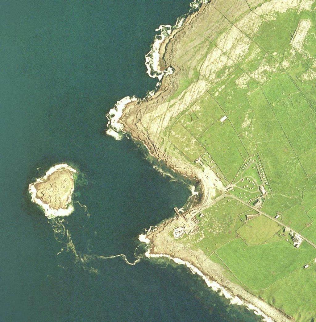
3 1 INTRODUCTION Clare County Council has applied to An Bord Pleanala for planning permission to develop a marine development in Doolin, County Clare. An Environmental Impact Statement (EIS) accompanies the planning application. The EIS documents the findings of many environmental studies that were undertaken in and around the vicinity of the proposed development. The results of these studies are described in the EIS and summarised in this Non-Technical Summary. 2 WHY THIS NEW PIER IS NEEDED Outside of Ros a Mhil, Doolin pier is the busiest pier for passenger traffic in Ireland. This is despite the fact that the pier is tidal, exposed, too small for the number and variety of users, and frequently congested. The pier is acknowledged as currently not fit for purpose. The pier is tidal for up to four hours a day. At low tide, trans-shipment is required to bring passengers to the ferries. This means that passengers have to be transported by a smaller vessel to the ferry waiting in deeper water. The existing pier offers no shelter as vessels overhang the pier. There are three major ferry operators operating out of Doolin and the boats are competing for limited space on the pier as the pier cannot cater for all of the ferries simultaneously. There is a large variety of users making demands on the pier. The pier is too small to safely accommodate all these different users. 1
4 A larger, more sheltered pier which would allow separation of users is needed in Doolin. This separation of users will increase safety, reduce congestion and allow the coast guard, commercial and recreational interests to operate safely and independently of each other. A new pier would also prevent the necessity for trans-shipment. 3 DESCRIPTION OF THE PROPOSED MARINE DEVELOPMENT The development will comprise of the construction of a 10m wide and some 103m long pier structure. Some of the pier structure will be constructed in the inter-tidal area. It is proposed to provide a minimum berthage length of 60m for Ferry type craft. The pier structure will be topped with a 2.25m high seawall. There will be dredging of a 40m wide area of seabed from deeper water to the pier, along the berthing face of the pier and into the inter-tidal area. The South facing side of the pier will be protected by a revetment. The revetment will consist of concrete unit primary armour overlying two layers of rock armour placed on a core of material obtained from the dredging arisings. There will also be an approach road of some 90m in length. The development will include the provision of power, lighting and water to the pier, and the installation of navigation aids, barriers, handrails, bollards, mooring rings, ladders and access steps, surfer access to the water and a cold water shower. There will also be a temporary extension and reconfiguration of existing parking facilities. 2
5 4 CONSIDERATION OF ALTERNATIVES A review of alternative pier options was undertaken as part of the Environmental Impact Assessment. Following a review of earlier work, findings, investigations and concerns three options were selected for final review. They represented what was considered to be the full range of locations for the provision of the required berthage and tidal access requirements. Option 1 was selected as preferred and for full assessment of environmental impacts on the basis that: It provides the required improvements to tidal access; It provides the required additional berthage length; It allows for separation of pier users between the new pier and the existing pier; It improves navigation safety in terms improved water depths and greater distance to the north shore; It allows the continuing use of the existing pier during the construction period; It provides protection to the existing pier; It is furthest from the Special Area of Conservation; 3
6 It allows for the more cost effective further expansion in terms of an extension to the pier and a deeper wider approach channel if ever required at a later date Option 2 is not preferred principally as it provides little protection to the berthage area from the direction of approach of the dominant waves (SW). It also provides little protection to the existing pier, and it encroaches on the Special Area of Conservation. Option 3 based on the existing pier is not preferred because: It is not as cost effective as Option 1 because of the greater volume of dredging required; It is limited in terms of providing for separation of use; The approach channel is close to the north shore and therefore is therefore inferior to Option 1 in terms of navigation safety; The existing pier would most likely have to be shut down for at least part (one summer, perhaps two) of the construction period. 5 ENVIRONMENTAL IMPACT ASSESSMENT The main objective of the Doolin pier EIA process is to ensure that all direct, indirect and cumulative environmental effects of the project are anticipated. Where effects are identified as unacceptable, these will be avoided or reduced during the design process through the implementation of practical mitigation measures. The main chronological stages of the EIA Process include: Baseline Studies and Data Collection; Impact Assessment Methodology; and Mitigation, Compensation and Enhancement. The EIA has been carried out in accordance with the relevant legislative requirements and guidelines including the Environmental Protection Agency (EPA) - 'Guidelines on information to be contained in an environmental impact statement, 2002'. Specialist guidance as required under each of the environmental topics have also been used where appropriate. 4


7 6 ENVIRONMENTAL TOPICS 6.1 WATER QUALITY During construction of the pier the potential will exist to negatively impact on water quality in Doolin harbour. The main potential to impact on water quality will come from the dredging of the new approach channel. Sediment can smother organisms and transfer contaminants. However an analysis of the tidal currents and the sediment size shows that there is very little fine material and no silt or mud. Most of the material to be dredged is rock with very small amounts of cobbles and coarse grained material on the sea bed. Tidal currents in the dredge area are slow, so any of the finer material will not travel far. Dredging will only take place in calm conditions. The risk of plant and machinery leaking fuel and oil is low however a management plan will be prepared to deal with such an eventuality. Similarly any waste or other potentially polluting material will be carefully managed during the construction phase to prevent pollution to the water in Doolin harbour. The construction methodology and water quality are discussed in detail in Chapter 2 and 5 of the main EIS 6.2 TERRESTRIAL AND MARINE ECOLOGY There will be a temporary loss of marine flora and fauna. None of the flora or fauna recorded is rare or protected. A protected ecologically sensitive area is partly located in Doolin harbour and Crab Island, namely the Black Head Poulsallagh Special Area of Conservation and proposed Natural Heritage Area. None of the flora and fauna for which the Black Head Poulsallagh Complex is protected, was recorded under the footprint of the proposed development. 5


8 The rock pools photographed during surveying did not contain any rare or protected species. The rock fill, revetment and pier base would over time be colonised by similar rocky shore species and the shelter provided by the pier will allow the colonisation of more species, increasing the biodiversity of the area directly in the lee of the pier. With regard to marine mammals, there would be no impact on seals at Inishmore or within the Inner Galway Bay area. There would be a potential impact on seals foraging in the immediate area of the development site during rock piling or blasting. Impacts on seals and dolphins and porpoises from the proposed development are likely to be acoustic in nature. An exclusion zone and Marine Mammal Observers will ensure there will be no harm to any marine mammals. 6.3 NOISE AND VIBRATION During construction there will be plant and machinery used to build the pier and for delivery and export of material. There will be noise associated with these operations. However the construction works will be phased and limited to daylight hours where possible. The works will also be temporary. Noise and vibration limits and working practices to minimise nuisance will be detailed in a Construction Environmental Management Plan to be developed prior to construction. Underwater noise from blasting has the potential to harm underwater mammals. An exclusion zone will be marked out around the working area. Marine Mammal Observers will be on site to watch for any marine mammal entering the exclusion zone (including Dusty the Dolphin, who is known to visit the area). Blasting will be stopped until the animals leave of their own accord. The exclusion zone has been calculated to ensure all mammals outside of this zone are protected. Chapter 6 explains in detail the underwater noise assessment carried out for this proposal. 6

9 6.4 DREDGING AND BLASTING Blasting will be required to remove rock from the sea bed to accommodate the dredge channel. This will be undertaken under strict control and supervision. The main impacts from blasting include the impacts of the noise on underwater mammals and sediment transportation from the removal of this material. The tidal currents in the vicinity of the proposed pier are low and the particle size of the material to be dredged is coarse grained size to cobble and boulders and broken rock. It will therefore not travel far and will not impact on the nearby Black Head Poulsallagh Special Area of Conservation and proposed Natural Heritage Area. Monitoring of the sediment in the water will take place during dredging and where levels are deemed height dredging will stop and only take place in times of calm water when the potential for sediment to travel is minimised. The sediment and coastal process are described in detail in Chapter 4 of the main Environmental Impact Statement. An exclusion zone will be marked out using buoys and if any underwater mammals enter this zone blasting will cease until the animal leaves of its own accord. 7


10 6.5 WAVES AT BALLAGHLINE POINT AND CRAB ISLAND Surfing is recognised as an important natural asset. The waves at Crab Island and Ballaghline Point are recognised as very good surfing waves. These waves however are not for everybody and are recommended only for the fit and experienced surfer. This is because of the rocky shore, underwater reef and long paddle required to reach them. There is the potential for reflection from the pier revetment to impact on these waves. The slope of the pier revetment has been designed to minimise any impact. A computer simulation model was built and used to predict the impact that reflection may have on these waves. The results found that there would be no significant impact on the waves at Crab Island and potentially a minor impact on the waves at Ballaghline point. These results are discussed in more detail in Chapter 4, Hydrodynamics and Sediment Regime. There are several access points to the waves along the rocky shore near the existing pier. One of the more popular access points will be lost as a result of the proposed development. However, as part of the new development a series of steps and platforms will be constructed to lead surfers safely to an alternative access point. A cold water shower for rinsing surfing gear and equipment will also be constructed beside the revetment. 8

11 6.6 TRAFFIC A flow capacity assessment was undertaken on the existing proposed haulage route road network to establish the estimated capacity of the proposed haulage route during the peak August tourist season. The analysis confirmed that the existing haulage route operates within capacity. Peak construction would occur in The increase in HGV volumes, on the proposed haulage route, during peak construction coinciding with the peak summer season, would be considered as significant impacts, in particular as these road links form part of important tourist and cycle routes. The likely increase in traffic through Doolin Village, during the peak construction and operational phases, in particular along the bridge on Fisher Street, could prove significant as this area currently experiences congestion during peak summer season and would require mitigation. A traffic management plan will be implemented to minimise disruption to local residents and visitors. Further details are available in Chapter 13 of the main Environmental Impact Statement, Traffic Impact Assessment. 9
12 6.7 ARCHAEOLOGY AND CULTURAL HERITAGE Ground works for the development will impact a recorded monument classified as a habitation site. The proposed development has previously been the subject of a Maritime Cultural Heritage Assessment incorporating an intertidal survey undertaken in June The results of this survey found that the proposed harbour development would not have any discernible impact on the underwater archaeology of the subject area. In advance of this development an excavation of this site was undertaken. The investigations exposed a series of archaeological deposits containing bone, shell, and charcoal. Two possible human teeth and a skull fragment were also recovered. According to preliminary excavation report the site probably represents the remains of a pre-historic midden. Midden sites are typically found scattered along the western seaboard and are defined as archaeological deposits of food refuse generally comprised of the remains of edible molluscs and occasionally containing animal bone. Middens can vary in size from a thin local layer to scatters of bone extending over a wide area. Due to the nature of these sites it is possible that there may be isolated deposits of archaeological potential within the footprint of the proposed development. All site ground works will be monitored by an archaeologist under licence to the National Monuments Service. In the event that archaeological deposits are exposed the archaeologist will be allowed sufficient time to sample, excavate and record the features appropriately. More details on the Cultural and Archaeological Assessment carried out for this proposal can be read in Chapter 11 of the main EIS. 10


13 6.8 LANDSCAPE AND VISUAL IMPACT The landscape of the Ballaghaline / Doolin area is both a natural resource and a cultural resource. Its beauty and diversity is important both to the quality of life of the local community and the economic prosperity of the region. It has a pleasing combination of natural attributes and historic man-made elements which are valued by the local population and wider public. It is an area with high scenic quality views towards the Atlantic and along the coast. Recreational opportunities are plentiful due in the main to the maritime nature of the area. The existing pier at Ballaghaline is a key feature of the local landscape and lends distinctiveness to the local seascape and coastline. The new pier will represent a new element within the local landscape. However, it is not considered that it would constitute an unacceptable or detrimental effect on either the local or wider landscape character or values. The proposed new pier development would not impart any notable change or loss of character to this area. The existing semi-rural coastal character of the area in essence will prevail. 11


14 The existing pier contributes significantly to local distinctiveness and thus the development of the new pier would assist in preserving this. The impact to both the local and wider landscape character area is seen as neutral as the proposed scheme would maintain existing landscape quality and character and is in keeping with local and regional land-use zoning objectives. 6.9 LOCAL COMMUNITY AND VISITOR EFFECTS During construction the local community and visitors to the area may experience some disruption in particular during the peak construction period. This disruption may take the form of noise nuisance, increased truck volumes and traffic congestion. There will be a degree of access restriction to the working area and water during times of blasting for health and safety reasons. However a Construction Environmental Management plan to minimise all these issues will be implemented. Once constructed, the new pier will accommodate all the commercial boat traffic including ferries and charters. The existing pier will be for the use of all others. This separation of users will reduce the risks associated with congestion and the current mix of users. The new pier will also provide shelter for the existing pier. The necessity for trans-shipment will also be eliminated which will improve the quality of the service for those taking a ferry to the Aran Island or to see the Cliffs of Moher. Efforts have been made in the design and location of the pier to minimise the impacts on the surfing waves at Crab Island and Ballaghline Point. It is predicted that there will be no significant impact on the waves at Crab Island and a minor impact on the waves at Ballaghline Point. An alternative access will be constructed for surfers to safely access the water and an outdoor cold water shower will be provided to rinse gear and equipment. 12
15 7 MANAGEMENT OF ENVIRONMENTAL IMPACTS Environmental impacts during construction will be managed through the design and implementation of a Construction Environmental Management Plan. This will address working hours, traffic management, control of pollution, waste management, noise, dust and vibration. Clare County Council will provide a public liaison officer to keep the public informed through the construction period. There will be put in place procedures regarding the handling of the explosives and their placing, packing and detonation, and, there will be procedures with regard to safety to the public, other harbour users and underwater mammals. Method statements and risk assessments will be prepared prior to undertaking blasting. In addition, adherence to the method statements and procedures will be supervised by the Gardai. 8 CONTACT INFORMATION Further detail relating to the above can be found in the Main Environmental Impact Statement and Appendices to same. A copy of the Environmental Impact Statement and the Natura Impact Statement, and the documents, particulars plans, and other information relating to the application, may be inspected at the following locations: Clare County Council, Aras an Contae, New Road, Ennis between the hours of 9.00 am and 5 p.m on working days from 9 th July 2012 to 20 th August 2012 (inclusive of both dates). Ennistymon Area Office, Ennistymon, Co. Clare between the hours of 9.30 am and 4.30 p.m on working days from 9 th July 2012 to 20 th August 2012(inclusive of both dates). the offices of An Bord Pleanála, 64 Marlborough Street, Dublin 1 between the hours of 9.15 am and 5.30 p.m on working days from 9 th July 2012 to 20 th August 2012(inclusive of both dates).. 13
3 CONSTRUCTION. 3.1 Construction Methods and Sequence. 3.2 Construction Sequence
 3 CONSTRUCTION 3.1 Construction Methods and Sequence The Construction Strategy for the offshore field and pipeline is described in the 2001 Offshore EIS. Some construction activities have taken place since
14.0 MARINE ENVIRONMENT
 14.0 MARINE ENVIRONMENT 14.1 INTRODUCTION This Chapter provides an assessment of the physical and ecological effects of the proposed marine facilities in Rupert s Bay. The proposed works at Rupert s Bay
# Post Consultation and Submissions Resource Consent Conditions for Surfing Impact Mitigation August 2016
 # Post Consultation and Submissions Resource Consent Conditions for Surfing Impact Mitigation August 2016 Surf Mitigation Management Plan 1 1 Not less than 6 months prior to the commencement of the construction
VLH Ltd, Nereide Ltd, Saltlake Resorts Ltd Proposed Beach Erosion Protection Works at Bel Ombre Environmental Impact Assessment
 VLH Ltd, Nereide Ltd, Saltlake Resorts Ltd Proposed Beach Erosion Protection Works at Bel Ombre TATO/EIA/01 Issue 15 February 2017 This report takes into account the particular instructions and requirements
14 NOISE AND VIBRATION
 14 NOISE AND VIBRATION 14.1 EXISTING ENVIRONMENT 14.1.1 The noise environment within Poole Harbour is generally characterised by low to medium noise levels depending on location. For example, certain areas
America s Cup 36, Auckland 2021 Marine Traffic Survey
 Report America s Cup 36, Auckland 2021 Marine Traffic Survey for Resource Consent Application, Wynyard Basin Prepared for Panuku Development Auckland (Client) Prepared by Beca Ltd (Beca) January 2018 Revision
BEFORE THE ENVIRONMENTAL PROTECTION AUTHORITY JOINT STATEMENT OF EXPERTS IN THE FIELD OF MARINE MAMMALS
 BEFORE THE ENVIRONMENTAL PROTECTION AUTHORITY IN THE MATTER of the Exclusive Economic Zone and Continental Shelf (Environmental Effects) Act 2012 AND IN THE MATTER of an Application for Marine D u m p
Name Assessor or Approver Date
 T: +44 (0)1224 295579 F: +44 (0)1224 295524 E: ms.majorprojects@gov.scot MARINE SCOTLAND LICENSING OPERATIONS TEAM S (MS-LOT) ASSESSMENT OF THE PROJECT S IMPLICATIONS FOR DESIGNATED SPECIAL AREAS OF CONSERVATION
Skomer Marine Conservation Zone Byelaws and Codes of Conduct
 Skomer Marine Conservation Zone Byelaws and Codes of Conduct BYELAWS The Marine Conservation Zone (MCZ) byelaws are summarised below. A copy of the MCZ byelaws is available free on request. The MCZ s byelaws
Case Study: Transportation Plan Environmental Impact Statement. National Park Service U.S. Department of the Interior
 National Park Service U.S. Department of the Interior Grand Teton National Park Wyoming Case Study: Transportation Plan Environmental Impact Statement November 2010 Brian T. Alward CRP 5540: Introduction
AGGREGATE DREDGING AND THE MARINE ENVIRONMENT
 AGGREGATE DREDGING AND THE MARINE ENVIRONMENT The marine Aggregate Levy Sustainability Fund ( marine ALSF ) programme represents one of the most substantial investments in UK marine research. The research
SA New Trial Artificial Reef Project
 BACKGROUND PAPER SA New Trial Artificial Reef Project Development of options for the trial artificial reef 1. Summary CONTENTS Each year, an estimated 236,000 South Australians participate in recreational
HARBOUR SEDIMENTATION - COMPARISON WITH MODEL
 HARBOUR SEDIMENTATION - COMPARISON WITH MODEL ABSTRACT A mobile-bed model study of Pointe Sapin Harbour, in the Gulf of St. Lawrence, resulted in construction of a detached breakwater and sand trap to
Chapter 20.0 Marine Noise and Vibration
 Chapter 20.0 Marine Noise and Vibration www.tidallagoonswanseabay.com www.tidallagooncardiff.com 20.0 Marine Noise and Vibration 20.1 Overview of existing situation 20.1.0.1 Estuaries by their nature (relatively
F4. Coastal Mooring Zone and moorings outside the Coastal Mooring Zone
 F4. Coastal Mooring Zone and moorings outside the Coastal Mooring Zone F4.1. Zone description This section addresses the provisions relating to moorings in the Coastal Mooring Zone and those outside the
Speed Limit Policy Isle of Wight Council
 APPENDIX B Speed Limit Policy Isle of Wight Council 2009 Contents Section 1 Introduction 1.1 Links with the Local Transport Plan Section 2 Speed Limits on Urban Roads and Residential Areas 2.1 20mph Limits
EXECUTIVE SUMMARY. Argyll Marine Special Areas of Conservation
 Argyll Marine Special Areas of Conservation Legislative Background Under the Habitats Directive (Council Directive 92/43/EEC on the conservation of natural habitats and of wild fauna and flora), Loch Creran
The Highways Agency is working to improve the M1 between junction 28 (near Alfreton) and junction 35a (the A616 Stocksbridge bypass).
 and junction 35a (the A616 Stocksbridge bypass).") Welcome The Highways Agency is working to improve the M1 between junction 28 (near Alfreton) and junction 35a (the A616 Stocksbridge bypass). The M1 is a vital part of the strategic road network, connecting
Welcome The Highways Agency is working to improve the M1 between junction 28 (near Alfreton) and junction 35a (the A616 Stocksbridge bypass). The M1 is a vital part of the strategic road network, connecting
I. Monitoring and Adaptive Management Approach. Potential Effects, Monitoring Studies & Mitigation
 I. Monitoring and Adaptive Management Approach Define the problem or management objective. Determine potential effects of the project on indicator species. Emphasis on examining potentially negative, rather
Tonight is for you. Learn everything you can. Share all your ideas.
 Strathcona Neighbourhood Renewal Draft Concept Design Tonight is for you. Learn everything you can. Share all your ideas. What is Neighbourhood Renewal? Creating a design with you for your neighbourhood.
Planning of Major Recreational Boating Facilities at Shell Cove Boat Harbour
 Planning of Major Recreational Boating Facilities at Shell Cove Boat Harbour B Morgan 1, Deborah Lam 1, Glenn Colquhoun 2 1 Advisian, Sydney, NSW 2 Frasers Property Australia, Shell Cove, NSW Abstract
Implications of proposed Whanganui Port and lower Whanganui River dredging
 PO Box 637 Wanganui 4540 Attention: Rowan McGregor Dear Rowan 1 Summary We understand that it has been proposed to bring large vessels into the Port at Whanganui requiring the excavation of a channel up
Request Number IR1-12: Flow Passage. Information Request
 Request Number IR1-12: Flow Passage Information Request Provide additional information about the 100 metre flow passage channel scenario between the Westshore Terminals and the proposed Project terminal
Habitat Fact Sheets. Rocky habitats are dominated by seaweeds and often mussels, which rely on the rocks for attachment.
 Habitat Fact Sheets Habitats in the Gulf of Maine serve many important roles for the environment and for humans as well. These include: cycling nutrients, filtering pollution, trapping sediments, storing
Habitat Development: Habitat Boulders Lawson Pier Foreshore Enhancement
 Habitat Development: Habitat Boulders Improve the existing habitat by stabilising beach sediments. Increase biodiversity by creating new habitats and colonisation opportunities. Loose cobble is unstable;
Marine Management Strategy Frequently Asked Questions
 Marine Management Strategy Frequently Asked Questions Can I still go fishing at Rottnest? Yes Where will I be able to go fishing on Rottnest Island? Recreational fishing can occur at any location outside
Welcome to the Open House
 Leslie Street Between 19 th Avenue and Stouffville Road Addendum to Class Environmental Assessment Study Welcome to the Open House Please sign in at the front desk. March 28, 2017 Richmond Green Sports
Environmental Protection on the Gold Coast of Queensland, Australia. 1. What is the appeal of the Gold Coast to tourists?
 Environmental Protection on the Gold Coast of Queensland, Australia Sections 1. What is the appeal of the Gold Coast to tourists? 2. How are Gold Coast visitor trends changing? 3. How can the impacts of
For more information: Photography: Rijkswaterstaat (Leo Linnartz, Carrie de Wilde, Jurriaan Brobbel, Joop van Houdt), Deltares
, Deltares") Investing in your future. This project was made possible with support from the European Regional Development Fund. Photography: Rijkswaterstaat (Leo Linnartz, Carrie de Wilde, Jurriaan Brobbel, Joop van
Investing in your future. This project was made possible with support from the European Regional Development Fund. Photography: Rijkswaterstaat (Leo Linnartz, Carrie de Wilde, Jurriaan Brobbel, Joop van
The Isar -Plan Project in Munich Great (Un) expectations.
 expectations.") The Isar -Plan Project in Great (Un) expectations. European River Restoration Conference Session 5- Enhancement of Multi-Use Landscapes 11-13 September 2013 The Isar-Plan Project: Basic Facts Approximate
The Isar -Plan Project in Great (Un) expectations. European River Restoration Conference Session 5- Enhancement of Multi-Use Landscapes 11-13 September 2013 The Isar-Plan Project: Basic Facts Approximate
Marine Environment Plans
 Marine Environment Plans 1 Marine Sediment Management Plan 2 Marine Sediment Management Plan: Overview What The Marine Sediment Management Plan (MSMP) describes management of marine sediment disturbed
Chapter Boat Harbour Areas Page 1
 Chapter 17 17.7 Boat Harbour Areas age 1 17.7 Boat Harbour Areas 17.7.1 Introduction Special facilities are located for the mooring and servicing of boats in two coastal areas of the City Half Moon Bay
Styal Golf Course Accommodation Works Environmental Statement Non-Technical Summary 1007/6.15.2/169
 Styal Golf Course Accommodation Works Non-Technical Summary 1007/6.15.2/169 September 2013 Document Control Sheet Project Title: Styal Golf Course Report Title: Non Technical Summary Document No: 1032775.014.001
Can we minimize the impact of vessel moorings on coastal habitats? An interagency management approach in Queensland
 Can we minimize the impact of vessel moorings on coastal habitats? An interagency management approach in Queensland Kurt Derbyshire 1, Rebecca Batton 1, Nicola Udy 2, Kimberly Foster 3 and Richard Marsh
Nicholas Brown. 31 Bennett Rd Wolfeboro NH Application submitted
 Nicholas Brown 31 Bennett Rd Wolfeboro NH 03894 603-856-5454 Nick4634@gmail.com Application submitted 8-12-2017 Description of proposed project A. General Methodology The site located approximately 600
Aberdeen Harbour Expansion Project. Construction Environmental Management Document
 Aberdeen Harbour Expansion Project Construction Environmental Management Document 11th May 2017 Contents Chapter 1 Chapter 2 Chapter 3 Chapter 4 Chapter 5 Chapter 6 Chapter 7 Chapter 8 Chapter 9 Chapter
Warfield Neighbourhood Plan: 4.4 Infrastructure
 Warfield Neighbourhood Plan: 4.4 Infrastructure Previously decided Policy headings: Policy WNP16 Transport Impact of Development Policy WNP17 Transport Proposals Policy WNP18 New School Buildings Policy
REVISED SILT CURTAIN DEPLOYMENT PLAN
 Contract No.: HY/2009/11 Central Wanchai Bypass, North Point Reclamation REVISED SILT CURTAIN DEPLOYMENT PLAN Name Prepared by: China Harbour Engineering Co., Ltd. China Road and Bridge Corporation Joint
Part 9 Specific Land Uses - Foreshore & Waterway Development
 7 FORESHORE AND WATERWAY DEVELOPMENT This section applies to the following development uses proposed within the foreshore area (defined by LM LEP 2014), and contains Council s specific requirements for
LAB: WHERE S THE BEACH
 Name: LAB: WHERE S THE BEACH Introduction When you build a sandcastle on the beach, you don't expect it to last forever. You spread out your towel to sunbathe, but you know you can't stay in the same spot
Gulf Harbour Village Marina Licence of Berth Terms & Conditions
 Gulf Harbour Village Marina Licence of Berth Terms & Conditions DEFINITIONS Agreement means the agreement entered into between the Berth Owner and the Berth Renter, to which these Terms and Conditions
Marine Protected Areas (MPAs)
") Marine Protected Areas This is one of a series of guides in which Seafish explores topical issues affecting the UK seafood industry. This guide takes a practical look at : what they are, the different
Marine Protected Areas This is one of a series of guides in which Seafish explores topical issues affecting the UK seafood industry. This guide takes a practical look at : what they are, the different
CHAPTER 6 10/29/2018 Clean Version REGULATING PIERS, WHARVES, MOORING BUOYS, SWIMMING RAFTS AND INFLATABLES ON ROCK LAKE
 1 2 3 4 5 6 7 8 9 10 11 12 13 14 15 16 17 18 19 20 21 22 23 24 25 26 27 28 29 30 31 32 33 34 35 36 37 38 39 40 41 42 43 44 45 46 CHAPTER 6 10/29/2018 Clean Version REGULATING PIERS, WHARVES, MOORING BUOYS,
Reference: Pacific NorthWest LNG Mitigation and Offsetting Commitments for Fish, Fish Habitat and Marine Mammals
 August 19, 2015 Alain Magnan Regulatory Reviews Manager Fisheries and Oceans Canada 3190 Hammond Bay Road Nanaimo, British Columbia V9T 6N7 Dear Mr. Magnan: Reference: Pacific NorthWest LNG Mitigation
Chiswell and Chesil Beach (to Wyke Narrows) 6a02 and 6a03 SUMMARY OF PREFERRED PLAN RECOMMENDATIONS AND JUSTIFICATION
 6a02 and 6a03 SUMMARY OF PREFERRED PLAN RECOMMENDATIONS AND JUSTIFICATION") Location reference: Policy Unit reference: Plan: Chiswell and Chesil Beach (to Wyke Narrows) 6a02 and 6a03 SUMMARY OF PREFERRED PLAN RECOMMENDATIONS AND JUSTIFICATION The long term aim for this section
Location reference: Policy Unit reference: Plan: Chiswell and Chesil Beach (to Wyke Narrows) 6a02 and 6a03 SUMMARY OF PREFERRED PLAN RECOMMENDATIONS AND JUSTIFICATION The long term aim for this section
North Rona Special Area of Conservation. Advice under Regulation 33(2) of The Conservation (Natural Habitats, &c.) Regulations 1994 (as amended)
 of The Conservation (Natural Habitats, &c.) Regulations 1994 (as amended)") North Rona Special Area of Conservation Advice under Regulation 33(2) of The Conservation (Natural Habitats, &c.) Regulations 1994 (as amended) 30 March 2006 About this Package: Section 1 of this document
North Rona Special Area of Conservation Advice under Regulation 33(2) of The Conservation (Natural Habitats, &c.) Regulations 1994 (as amended) 30 March 2006 About this Package: Section 1 of this document
Tenby and Caldey Island
 No: 39 Seascape Character Area Name: Tenby and Caldey Island Tenby with spire from the south Tenby North Beach with harbour Tenby- sailing dinghy activity off North Beach View across to Caldey island from
Loughborough University Travel Planning
 Document Ti tle Client Name Loughborough University Travel Planning Loughborough University Travel Plan Executive Summary 2015-2020 23 December 2015 Loughborough University Travel Planning Project no:
SAFETY OF NAVIGATION STANDARDS IN THE PORTS OF NAUTICAL TOURISM WITH A SPECIAL FOCUS ON THE MAINTENANCE OF THE PORT ORDER
 SAFETY OF NAVIGATION STANDARDS IN THE PORTS OF NAUTICAL TOURISM WITH A SPECIAL FOCUS ON THE MAINTENANCE OF THE PORT ORDER Ranka Petrinović, Ph. D, Full Professor Nikola Mandić, Ph. D, Assistant Professor
Welcome to the Public Meeting. Red Hill Business Park South Transportation Master Plan Addendum. December 4, :00 p.m. to 8:00 p.m.
 Welcome Welcome to the Transportation Master Plan Addendum December 4, 2012 6:00 p.m. to 8:00 p.m. Please sign-in Background PIC#1 Public Information Centre #1 (PIC#1) was held on June 25, 2012. Feedback
THIS PAGE INTENTIONALLY BLANK
 THIS PAGE INTENTIONALLY BLANK Readers Guidance: This chapter provides responses to all comments submitted on the Draft Supplemental EIR of November 2011. All comments have been numbered and a corresponding
Welcome. Knutsford to Bowdon Improvement. Start of works exhibition November An executive agency of the Department for Transport
 Start of works exhibition November 2014 Welcome Scheme plan A56 Bowdon A56 M56 Booth Bank Junction 8 M56 Millington Lane Cherry Tree Lane Junction 7 Millington Hall Lane Rostherne Mere Rostherne Lane N140519
MARINE SAFETY PLAN
 PORT MARINE SAFETY CODE MARINE SAFETY PLAN 2015-2017 Introduction As required at article 3.20 of the Port Marine Safety Code (PMSC), the Port of London Authority (PLA) publishes its Marine Safety Plan
Procedure: Work health and safety hazard management
 Procedure: Work health and safety hazard management Purpose This procedure describes how the Australian National University (ANU) manages Work Health Safety hazards for the health, safety, rehabilitation
Guiding Principles: Key Guiding Principle numbers: 1, 5, 15, 16 and Introduction Yachting / Motor Boating
 Chapter 10 Recreation & Tourism Guiding Principles: Chapter 4 details all the guiding principles relevant to the overall management of the Harbour. Whilst all should be given some consideration the following
3.9 Recreational Trails and Natural Areas
 3.9 Recreational Trails and Natural Areas 3.9.1 Introduction Parks and other recreational facilities such as trails, bicycle routes, and open space are important community resources. This section discusses
Appendix 3. Hydrodynamic and sedimentation studies
 Appendix 3 Report EX 4945 Rev 3.0 November 2004 Document Information Project Report title Client Borough of Poole Client Representative Mr Stuart Terry Project No. DDR3553 Report No. EX 4945 Doc. ref.
APPENDIX 2 PROPOSAL FOR REPLACEMENT FOR POOLE (DOLPHIN) LEISURE CENTRE FINAL SPECIFICATION
 LEISURE CENTRE FINAL SPECIFICATION") APPENDIX 2 PROPOSAL FOR REPLACEMENT FOR POOLE (DOLPHIN) LEISURE CENTRE FINAL SPECIFICATION 1 PURPOSE 1.1 To provide the following information and supporting evidence for the Member decision (reference
APPENDIX 2 PROPOSAL FOR REPLACEMENT FOR POOLE (DOLPHIN) LEISURE CENTRE FINAL SPECIFICATION 1 PURPOSE 1.1 To provide the following information and supporting evidence for the Member decision (reference
Appendix A - Management of the CMA Recommended Changes and section 32AA assessment
 Appendix A - Management of the CMA Recommended Changes and section 32AA assessment This table sets out only the provisions of the notified proposed Plan on this topic for which submissions were specifically
City of Toronto Complete Streets Guidelines
 Round One This is a summary of the Complete Streets Guidelines Survey posted on June 18 th, 2015 and live until July 2 nd, 2015. The survey was designed to solicit feedback on the draft Complete Streets
SHOREHAM BEACH LOCAL NATURE RESERVE
 SHOREHAM BEACH LOCAL NATURE RESERVE Coastal Geography Education Programme 2014-15 S. Savage 2014 COASTAL GEOGRAPHY OPPORTUNITIES Shoreham Beach Shoreham Beach is a shingle spit formed over many centuries
X coordinate. Y Coordinate. 0 UD_ Partial No. 1 Gorton Hall Drain Yes No. 2 UD_ Yes No
 Appendix 7 Otter Information Table A7.1 Otter Survey Results Site No. Watercourse ID X coordinate Y Coordinate Access Otter Presence 0 UD_01 240518 412322 Partial No 1 Gorton Hall Drain 239812 411376 Yes
Harriet Fraser Traffic Engineering & Transportation Planning
 Appendix 5: Traffic Assessment 71 26 February 2015 Mr James Beban Senior Resource Consents Planner Cuttriss Consultants Ltd PO Box 30429 Lower Hutt PO Box 40170 Upper Hutt 5140 P 04 526 2979 M 027 668
CRUISE BERTH PROJECT AT DUN LAOGHAIRE HARBOUR
 RESPONSE TO PUBLIC COMMENTARY ARISING FROM STAKEHOLDER/PUBLIC CONSULTATION EXERCISE HELD IN MARCH/APRIL 2015 CRUISE BERTH PROJECT AT DUN LAOGHAIRE HARBOUR For DUN LAOGHAIRE HARBOUR COMPANY ON BEHALF OF
RESOURCE CONSENT APPLICATION FOR B & R MCKENZIE MOETAPU BAY. Our Ref: Date: November2015. Our Ref:
 RESOURCE CONSENT APPLICATION FOR B & R MCKENZIE MOETAPU BAY Our Ref: 25876 Date: November2015 Our Ref: 25876 1 Our Ref: 25876 16 November 2015 1. BACKGROUND INFORMATION IN SUPPORT OF A RESOURCE CONSENT
CHAPTER 8 ASSESSMENT OF COASTAL VULNERABILITY INDEX
 124 CHAPTER 8 ASSESSMENT OF COASTAL VULNERABILITY INDEX 8.1 INTRODUCTION In order to assess the vulnerability of the shoreline considered under this study against the changing environmental conditions,
The Sea Geography Notes JC-Learn. JC-Learn. Geography Notes The Sea. 1 P a g e
 JC-Learn Geography Notes The Sea 1 P a g e The Sea *Here, you can choose to study the chapter on glaciation or the one on the sea, or even both, because whenever these topics come up in the Junior Cert
INTRODUCTION TO COASTAL ENGINEERING
 The University of the West Indies Organization of American States PROFESSIONAL DEVELOPMENT PROGRAMME: COASTAL INFRASTRUCTURE DESIGN, CONSTRUCTION AND MAINTENANCE A COURSE IN COASTAL DEFENSE SYSTEMS I CHAPTER
COFFS HARBOUR BOAT RAMP LONG WAVE DATA COLLECTION TO EVALUATE PERFORMANCE OF BASIN EXTENSION WORKS
 COFFS HARBOUR BOAT RAMP LONG WAVE DATA COLLECTION TO EVALUATE PERFORMANCE OF BASIN EXTENSION WORKS M Kulmar 1, I Jayewardene 1, M Glatz 1, M Robertson 2 1 NSW Government, Manly Hydraulics Laboratory (MHL),
Voting should indicate preference to one option (Option 1, Option 2, or Option 3)
") Proposals for Wied Il-Buni Options being considered for proposal for the Ministry of Infrastructure to be taken up with Transport Malta following the extension of Terminal 1 by Malta Freeport Corporation.
Proposals for Wied Il-Buni Options being considered for proposal for the Ministry of Infrastructure to be taken up with Transport Malta following the extension of Terminal 1 by Malta Freeport Corporation.
Submission on the proposed New Zealand Coastal Policy Statement 2008 Sections 49 and 57 of the Resource Management Act 1991
 Submission on the proposed New Zealand Coastal Policy Statement 2008 Sections 49 and 57 of the Resource Management Act 1991 To: Board of Inquiry Proposed NZCPS C/- Department of Conservation PO Box 10
WELCOME TO OPEN HOUSE # 1 June 14, 2017
 Langstaff Road Weston Road to Highway 7 Class Environmental Assessment Study WELCOME TO OPEN HOUSE # 1 June 14, 2017 Please sign in and join our mailing list Purpose of Open House #1 & Study Area York
Surf Survey Summary Report
 Port Otago Limited 15 Beach Street Port Chalmers Surf Survey Summary Report August 13-September 1 Leigh McKenzie Summary of Surf Locations of Interest Port Otago Ltd is undertaking monitoring of changes
HELCOM Submerged and The Nairobi International Convention. HELCOM Submerged Expert Group meeting in Bonn, Germany, 22 nd of April 2015
 HELCOM Submerged and The Nairobi International Convention HELCOM Submerged Expert Group meeting in Bonn, Germany, 22 nd of April 2015 The Nairobi International Convention on the Removal of Wrecks 2007
Instructions for the Use of the Excel Spreadsheet. There are Three tabs at the bottom of this worksheet. Instructions tab is the one you are reading
 Instructions for the Use of the Excel Spreadsheet There are Three tabs at the bottom of this worksheet Instructions tab is the one you are reading H&S Plan Tab The Plan Tab is the front cover pages of
RESOLUTION MEPC.136(53) Adopted on 22 July 2005 DESIGNATION OF THE BALTIC SEA AREA AS A PARTICULARLY SENSITIVE SEA AREA
 Adopted on 22 July 2005 DESIGNATION OF THE BALTIC SEA AREA AS A PARTICULARLY SENSITIVE SEA AREA") MEPC 53/24/Add.2 RESOLUTION MEPC.136(53) THE MARINE ENVIRONMENT PROTECTION COMMITTEE, BEING AWARE of the ecological, social, economic, cultural, scientific and educational value of the Baltic Sea Area,
MEPC 53/24/Add.2 RESOLUTION MEPC.136(53) THE MARINE ENVIRONMENT PROTECTION COMMITTEE, BEING AWARE of the ecological, social, economic, cultural, scientific and educational value of the Baltic Sea Area,
Why Opencast Coal Mining? David Gosling and Sam Thistlethwaite Banks Mining
 Why Opencast Coal Mining? David Gosling and Sam Thistlethwaite Banks Mining CPRE s VIEW OF OPENCASTING Not only do opencast mines deface some of our finest landscapes and wreck tranquillity, they can have
MARINE ANTIQUITIES SCHEME
 For more information on the Marine Antiquities Scheme visit www.marinefinds.org.uk The MAS support team Wessex Archaeology Portway House Old Sarum Park Salisbury SP4 6EB T: 01722 326867 E: mas@wessexarch.co.uk
TRANSPORTATION NEEDS ASSESSMENT
 TRANSPORTATION NEEDS ASSESSMENT A travel demand analysis was carried out to determine the operational issues and the potential benefit that adding traffic capacity would have on the road network. All the
CONTENTS PREFACE 1.0 INTRODUCTION AND SCOPE 2.0 POLICY AND GOVERNANCE 3.0 SUMMARY OF PROGRESS 4.0 NATURE OF DEMAND 5.0 TRAVEL AND PARKING INITIATIVES
 CONTENTS PREFACE 1.0 INTRODUCTION AND SCOPE 2.0 POLICY AND GOVERNANCE 3.0 SUMMARY OF PROGRESS 4.0 NATURE OF DEMAND 5.0 TRAVEL AND PARKING INITIATIVES 6.0. TARGETS PREFACE The University of St Andrews has
Investigation of Cultural and Environmental History on the Hudson River Superfund Site, NY February 2011
 Investigation of Cultural and Environmental History on the Hudson River Superfund Site, NY February 2011 Summary Waterline Design / Pre-construction Phase I Archeological Survey Phase II Archaeological
Waikanae River Environmental Strategy. 12. Arapawaiti/Otaihanga Reach
 74 Waikanae River Environmental Strategy 12. Arapawaiti/Otaihanga Reach Figure 12: Arapawaiti/Otaihanga Reach 75 PART C: Protecting and Improving the River Corridor / Arapawaiti/Otaihanga Reach Waikanae
POOLE HARBOUR APPROACH CHANNEL DEEPENING EIA: SEDIMENT MANAGEMENT PLAN
 POOLE HARBOUR APPROACH CHANNEL DEEPENING EIA: SEDIMENT MANAGEMENT PLAN 1. Introduction The purpose of the Poole Harbour Sediment Management Plan (SedMP) is twofold: to mitigate the predicted impact of
North Coast Corridor:
 North Coast Corridor: Connecting People, Transportation & Environment Legislative Hearing: 11.8.10 1 North Coast Corridor Region s Lifeline A Regional Strategy Mobility, Economy & Environment North Coast
Hydrographic Surveying at The Port of London
 Hydrographic Surveying at The Port of London John Dillon-Leetch Port and Terminal Technology 2009 14 th October, Antwerp Overview Introduction Surveying the Thames Navigational Charting High Resolution
Breakwater Wharf Encasement Hant s Harbour, Newfoundland
 ABSTRACT Breakwater Wharf Encasement Hant s Harbour, Newfoundland Jamie Downey Memorial University of Newfoundland St. John's, NL, Canada jdowney@mun.ca Hant s Harbour, a small fishing community located
Provisions for Moorings
 Provisions for Moorings Tasman Resource Management Plan Summary Guide No. 11 Current: July 2013 1. Introduction Structures and occupation of the coastal marine area (CMA) are managed to control the location
Guidelines for fishing for sharks posing an imminent threat to public safety
 Guidelines for fishing for sharks posing an imminent threat to public safety Background Following five fatal shark attacks in Western Australia over the twelve months to September 2012, the Government
Eelgrass and Macroalgae Presence/Absence Preliminary Surveys BHP Proposed Grays Harbor Potash Export Facility A Task 400
 Memorandum 40600-HS-MEM-55036 Revision 0 Date: 26 July 2018 Subject: Eelgrass and Macroalgae Presence/Absence Preliminary Surveys BHP Proposed Grays Harbor Potash Export Facility A17.0202.00 Task 400 INTRODUCTION
About AMETI. Features and benefits. Stage One Panmure complete
 About AMETI The Auckland Manukau Eastern Transport Initiative (AMETI) is a group of projects that will give residents of South Eastern suburbs improved transport choices and better connect them to the
Figure 4, Photo mosaic taken on February 14 about an hour before sunset near low tide.
 The Impact on Great South Bay of the Breach at Old Inlet Charles N. Flagg and Roger Flood School of Marine and Atmospheric Sciences, Stony Brook University Since the last report was issued on January 31
Coastal and marine recreation in New England is ingrained in the region s economic and
 RECREATION Coastal and marine recreation in New England is ingrained in the region s economic and social fabric. Recreation on the ocean and coast includes many of New Englanders most time-honored and
2. Context. Existing framework. The context. The challenge. Transport Strategy
 Transport Strategy Providing quality connections Contents 1. Introduction 2. Context 3. Long-term direction 4. Three-year priorities 5. Strategy tree Wellington City Council July 2006 1. Introduction Wellington
Table of Contents. Bakkafjara Ferry Port. Icelandic Maritime Administration. Review of IMA provided reports. 1 General
 Icelandic Maritime Administration Bakkafjara Ferry Port Review of IMA provided reports COWI A/S Parallelvej 2 DK-2800 Kongens Lyngby Denmark Tel +45 45 97 22 11 Fax +45 45 97 22 12 wwwcowicom Table of
Wave Prediction in the Santa Barbara Channel
 Wave Prediction in the Santa Barbara Channel OCS Study MMS 2001-055 Final Technical Summary Final Study Report U.S. Department of the Interior Minerals Management Service Pacific OCS Region Wave Prediction
Fact sheet. Badgers A Guide for Developers. January Page 1 of 8
 Fact sheet Badgers A Guide for Developers www.naturalresourceswales.gov.uk Page 1 of 8 Contents Introduction 3 Biology and lifestyle 3 Badgers and the planning system 3 Badgers and the law 4 What should
Artificial Reef Uses. Mitigation Shore Protection Scientific Studies Habitat Creation Conservation Economic Stimulus Diver Attractions
 Artificial Reef Uses Mitigation Shore Protection Scientific Studies Habitat Creation Conservation Economic Stimulus Diver Attractions Barbados Study The Relationship between Diver Experience Levels and
The Sand Beaches of New Hampshire and Maine
 The Sand Beaches of New Hampshire and Maine Beach Preservation and Erosion Control Photographs provided by Joe Kelly and Steve Adams Cover photo: Reid State Park, ME Introduction The sand beaches of New
N. Tay Evans Marine Fisheries Biologist & Technical Review Coordinator
 Massachusetts Division of Marine Fisheries Marine Fisheries Resource Recommendations: Time-of-Year Restrictions N. Tay Evans Marine Fisheries Biologist & Technical Review Coordinator Massachusetts Division
Living Streets response to the Draft London Plan
 Living Streets response to the Draft London Plan Contents Living Streets response to the Draft London Plan... 1 About Living Streets... 2 Summary... 2 Consultation response... 3 Chapter 1: Planning London