BACHELOR'S THESIS. Traffic Communication. Joakim Borg Samantha Lütkeman Pukala
|
|
|
- Gary Jordan
- 6 years ago
- Views:
Transcription

1 BACHELOR'S THESIS Traffic Communication Joakim Borg Samantha Lütkeman Pukala Bachelor of Science in Engineering Technology Industrial Design Engineering Luleå University of Technology Department of Business Administration, Technology and Social Sciences
2 Foreword This report is the result of a thesis project D0016A for a högskoleingenjörsexamen that is resembled with a bachelor s degree in industrial design engineering at Luleå University of Technology period four during the spring semester 2011 Thanks to Professor Håkan Alm for giving support and mentoring from LTU. Special thanks to Michael Prince and the team at Beyond Design for great guidance and all the help given. Thanks for providing high quality tools, programs and equipment to achieve a process and result not else possible.
3 Abstract The project was started in Sweden at Luleå University of Technology but carried out in Chicago in cooperation with Beyond Design Inc. Beyond Design Inc. is a consultant company who has done designs for various brands. The company has provided guidance, programs and equipment to help carry out the project. The project investigates traffic communication with the goal to see what improvements can be done within the subject s nature, safety and technology. Traffic communication in this context means the interaction between the users in the traffic. Today this communication is mostly done through traffic lights, but in this project the focus is on the communication in traffic and what can be developed within it rather than the traffic light itself. The human senses are channels to interpret information. This project investigates if there are other ways to give and understand the same message but in another way. Today vision is the main sense used in traffic with lights and signs signaling to drivers and pedestrians. But is this still the optimal way considering the development of technology in the past decades? Through various steps in the design process like video documentation, brainstorming, evaluation process and refinement in various programs a direction for the project was set. The result is presented in a CAD model. New solutions, designs and concepts are adapted for the user where the system controlling the intersection should be adjusted after the user needs. A total centralization is the basic thought. Existing technology that are separated today is brought together to make traffic communication controlled by the users. Nature is brought in to lower the feeling of stress as well as reduce noise. In the safety aspect the traffic light device signals from which direction an emergency vehicle is approaching. The physical design of the intersection is made so that intuitive actions control the user s behavior and structure of the crossing. Key words: Traffic, Lights, Communication, Intersection, Crossing, Centralization, Nature, Safety, Technology, Integration, Intuitive
4 4.5 Design exploration Contents 1. Introduction Background Purpose and Objectives Boundaries Description Today Future Theory Safety Nature Technology Man machine interaction and psychology Method and Implementation Personas Programs Photo and video documentation Analys Brainstromning Evalutaion Processes Design exploration Test Survey Concept Final concept Presentation Result Timeline Processes Personas Evaluation Test Survey Analys and problem determinasion Solution Solution determination Specification Solution development Final solution and evaluation Discussion References Appendix 3
5 1. Introduction This thesis project was done in Chicago, USA, to get more out of the experience of working in close cooperation with a company. The subject traffic communication even adds to this experience as cultural and society differences have to be taken in consideration. 1.1 Background Beyond Design is a Chicago based industrial design firm established in The company has about 17 employees and has worked as design consultants for brands like Dremel and Remington. Product development is done through various processes and strategies not only concerning design but also lifestyle and customer desire. When first contact was made with Beyond Design and cooperation was initiated an exchange of cultural differences and experiences were the main objectives regardless of subject chosen to work with. As the process went further three subjects were chosen. This was done so that main focus would be on the work process and a greater chance for a good end result would be given. Safety, nature and technology were all three associated with traffic lights, traffic situations and communication. Since there is a fairly similar system throughout the world but still slight differences between countries this was thought to be an appropriate system and product to further investigate. Looking back in history traffic has not developed much when it comes to design and symbols. The first traffic light was used for the railway and installed 1868 in England 1. Signals were given through semaphore arms and red and green gas lamps at night. Red and green is /john_peake_knight_traffic_lights_feature.shtml still signals for stop and go and amber has been added to signal caution and wait. Circular lights placed in a vertical row have been the formation almost since the start. The only way to interpret the signal for color blind people is by placement of the light glowing. Still the communication in traffic situations is such a fundamental part of the public space and society. Everyone uses transportation in some way on a daily basis, both pedestrians and vehicles. Pedestrians in the form of children, elderly, handicapped and the vehicles as bikes, trucks, cars and emergency vehicles and so on. That is why traffic communication is such an important subject. It is one of the few things that have to be designed for everyone and really no exceptions can be made. Still it is such a widely spread system throughout the world and therefore a change would take a long time to implement. It is time to change the traffic communication so that the user is not controlled by the system, but the user controls the system instead. 1.2 Purpose and Objectives The purpose of the project is to work through a process of different steps. Methods used in these steps will in the end lead to a final result not known from the beginning. Carefully working through these methods will teach to trust the process. The goal of the project is to create an innovative solution that brings safety, nature and technology together to found a new starting point for future thinking within traffic communication. 1.3 Boundaries The project is restricted by the time of approximately eight weeks given and sources of information. 4
6 The time frame limits the depth of the results of such a broad and diverse subject as traffic communication. The final result will not be a tangible solution able to implement today or possible not even in the future. No exact measures, interfaces, materials or such are stated or thought of. No actual research from a governmental or professional source stands behind this project. This is also a consequence by the time limitations as such a research would be time consuming. Interpreting studies and statistics from both USA and Sweden would request a deeper understanding of both countries road and traffic system. Finding sources providing that information have not been done in this project. The project has not had various inputs. Processes, materials and programs have only been provided by Beyond Design but have been an asset more than a restriction compared to what probably would be accomplished without help from the company. 5


7 Image 1 Different signs that communicates with both pedestrians and vehicles 2. Description Even though there are differences between most countries in the way of planning and designing infrastructure some fundamental structures are still the same. Following chapters will in a generalizing way describe similarities and differences. 2.1 Today Today s traffic communication is based on laws to obey. This are structured in an hierarchy in following order, 1. Police 2. Traffic light 3. Signs Intersections are often equipped with traffic lights in areas where heavy traffic occurs. The most common traffic light contains three different lights, green (go), yellow (wait) and red (stop). They are placed in an order where it is easy for color blind users to interpret. One traffic light only contains one light for each color, which means that it only communicates with one road direction. he road often has a number of lanes in each direction. They can each have their own traffic light or all be controlled by the same one. When stopping at a traffic light there is a thick white line painted on the ground to mark where to stop. There are two kinds of traffic lights, one of them communicates with pedestrians and the other with vehicles. The path for the pedestrian is defined by white thick lines followed by each other in a vertical direction, referred to as a zebra crossing in USA. The pedestrian device has different designs depending on country. In the United States it is common with both text and symbols (image 1). In special situations a police officer, or traffic police, is placed in the middle of the road to control the traffic flow. Within situations where traffic lights are installed signs are supposed to be installed to backup traffic lights if they breakdown. The signs are stop signs and stop lines painted in the ground. Special features are installed in the intersection to fulfill certain need of blind, deaf and persons who have reduced movability. In Sweden there are bricks in the sidewalk letting blind people know when they reach a crossing. The traffic lights for pedestrians also give a sound where the intensity varies depending on if you can cross or not. In the city of Chicago bricks have been placed when the crossing is entered. This gives the pedestrian tactile feedback as well as feedback with the color change in the sidewalk. 6
8 2.2 Future More roads outside of the cities, highway expresses as bridges, investments in public transportations, these are all factors that have been used today to prevent traffic jams, and will probably be the solution within the future as well. It is difficult to see the direction of the development when it comes to traffic communication. It is hard to make changes that will have an impact in a short time span since the whole system is of such a massive extent. But even in a broader, longer time span it is hard to see what could happen in the future. It is easier to look back and compare now and then to see changes in time. Google has developed a car that drives itself 2. This is done with a laser and a GPS device. The laser scans the surrounding and the GPS is used to determine to go from A to B. Volvo is also using the laser technology by preventing accidents to happen by in case of an emergency break the vehicle
9 This table describes the statistics data of International traffic accidents in the year of 2007 Country Deceased Citizen Vehicles Deceased per Deceased per Miljons Thousands citizens motor vehicles Swedn 471 9, ,2 8,9 USA , ,2 17,0 Source: Statistics of International traffic accidents 2007, IRTAD Table 1 3. Theory Many different approaches can be taken in investigating traffic situations and communication. As three subjects were chosen from the beginning theory from that point of view has been researched as a way to set direction for the project and in the end the result. 3.1 Safety Safety is a big factor when it comes to traffic in general. Three areas have been found within safety which can be applied on the project, the environment, equipment and the law. The environment around us plays a great roll in how safe we feel and how safe it actually is. Well maintained roads, barriers between opposite lanes, reflecting signs and paint, and speed bumps on the road are all there to warn and protect. Creating a calm environment that slows traffic down resulting in a slower pace is something that could be in addition to speed regulations. There is a lot of equipment in a vehicle that are there for safety. Seatbelts, airbags and the horn are there to decrease the impact if an emergency situation occurs. The law is there to regulate and protect the society. It provides safety in a way of controlling speed, maneuvers, actions and vehicles travelling on the road. The regulations in the form of traffic light, road formations, signs and signals are there to protect the users and create a structure. Most countries have government departments that control the development and planning of roads, infrastructure and the safety around it. In Sweden Nollvisionen 3 is a point of direction for the state where the goal is that zero people should be killed in traffic. Looking at statistics in table 1 Sweden has lower numbers than the USA but still not zero thus the point of direction. So the development of new strategies to work with is still needed. A difference noticed is that in general the infrastructure in the USA is planned after the motor vehicles and everyone is striving to have their own car. In Sweden, though there are a lot of benefits from a good infrastructure for transportation, there is more focus on a good interaction and balance between prioritizing pedestrians and vehicles. For example the age to have a driver license is 16 in the USA and 18 in Sweden. In the suburbs outside Chicago the fire trucks use the Opticom 4 system that is integrated with the traffic lights. The Opticom system detects the flashing lights and then turns the /opticomp.htm 8


10 Image 2 Image 3 Roads for ants signal for the cars to red to give the fire truck the righter way. In Västerås 5, Sweden for example the time that the traffic light shows stop or go is regulated by the amount of cars in a direction in the intersection. If a queue is building up they get a green light for a longer time than a single car in another direction. This is done by help from sensors in the road detecting metal. Also public transportation like busses gets the righter way when coming to an intersection. A radio transmitted signal is sent to the traffic light that changes to green when the buss enters the intersection. 3.2 Nature The city environment is usually thought of as grey and dull. Concrete and asphalt are common materials for roads and sidewalks and equipment like traffic lights are made of metal and plastic, not very natural materials but sustainable. Studies 6 at university of Stockholm show the importance of keeping or maybe bringing in nature in to the city. The benefits are many like cleaner air and noise reduction. But also the effect nature has on the human. With urbanization today many seek new ways to bring nature back in a 5 Closeup, roads for ants natural way. One example is daycare specializing on spending a lot of the time with the children outside having a bus as their base taking the children to new places. Often nature and city are put as opposites. Comparing concrete and asphalt to natural bright colors in the form of leafs and flowers make a great contrast. New city planning often includes green areas. This because green has a calming 7 effect compared to other colors, and the connection that green comes from natures chlorophyll is not so far off. Looking at systems in nature ants are often looked at when working with roads and traffic. Experiments 8,9 show that ants have a well organized system to get an optimized flow to and from the anthill. In the experiment, different roads for the ants to walk on were created (image 2, 3). When the road got too narrow for ants travelling in opposite directions to meet the prioritization was shown. Ants bringing food back to the anthill got the righter way. This because all ants have the same algorithm programmed. An algorithm is usually programmed to give a certain output from a specific given input. The ants work like this and therefore have a very effective workflow. et/sidor/trafiksignaler.aspx 6 nden/naturistadenhurforvemochtillvad f412e262f9 f0c html
11 3.3 Technology The GPS 10 technology can be used to plan routes. This is mostly done by the user, and for his or her own benefit. By gathering information from stored information within the GPS or a network a route is planned and the user gets the information that is needed to get from A to B. The information that is used is maps and the user s position. The maps are mainly from old information collected from the past, though the user s position is updated in present time. The technical evolution is faster than the political system which means that more solutions to overpopulation are found within this area. People can today use applications in their computer devices to prevent problems such as traffic jams Man machine interaction and psychology When creating new systems and devices it is important to create these according to the human capability instead of vice versa 12. How far can multitasking and concentration be taken without interfering with each other and cause danger? A higher pace and complexity in today s information focused society cause what is referred to as information stress 13. Interpretation of information is done by the five senses. They are dominated by the visual impression. Hearing often comes as a compliment but can on the contrary receive information from 360 degrees and the human reacts faster on noise than light. Looking at ways of paying attention there are three categories. Selective attention is when there is an overflow and what to pay attention to has to be selected. Focused attention is Teknisk Psykologi, Mats Danielsson, 2001, page Håkan Alm, LTU, 2011 concentration on one source and to disregard distractions. Split attention is focusing on two or more sources without missing any information 14. Another thing to consider is the multiple resource theory stating that multitasking can be differently successful depending on what resources the tasks demands 15. This means that two rather simple exercises can be hard to perform at the same time if they use the same resources, like both demanding hearing. There also limitation in the short term memory of how many units that can be remembered, usually 5 to 9 units 16. Reducing the chances of mistakes, slips and stress that leads to forgetting or confusion could be making mental models of a system. Even though the user can not literally see what is going on a mental model gives an idea of the flow, structure and consequences of actions. When it comes to communication certain conditions needs to be fulfilled. Communication needs to be detectable when it starts, able to perceive under the time it lasts and understand it 17. Colors and symbols for communication in traffic have been the same almost since the beginning of using traffic lights. Circles colored red for stop, amber for wait and green for go is a standard in many countries. According to color guidelines 18 the pairs red and green, red and blue and green and blue should be avoided. Combining symbols with colors is an effective way to get redundant information that is very useful in traffic communication. An example of that with today s traffic lights is that the lights both have different placements and colors in order to signal. 14 Teknisk Psykologi, Mats Danielsson, 2001, page Wickens, 1984, Håkan Alm, LTU, Håkan Alm, LTU, Håkan Alm, LTU, Håkan Alm, LTU,
12 Systems and products needs to be constructed for when failure occurs. Not if it occurs but when it occurs because with larger and complex systems it will. From the operators actions there are two ways to fail with the operations. One is mistakes and that happens when the operator misunderstands the system they are working with and therefore performs the wrong action. Slips are causes by a lack of concentration. Slips are made during the performance of an action Method and Implementation The design process can be carried out in different ways but is an iterative process containing various steps. A time plan is made in the beginning showing what steps that should be included and also how long they each should take. Even though they might be separated in the schedule they are usually done parallel or repeatedly. 3.6 Personas Eight different personas were created with the purpose to show the different needs having to be met in intersections and traffic communication. These personas were created in an early stage in the project and used as a reference in what to look for during the documentation. The information and pictures of the personas were applied to fit posters. 3.7 Programs Some sketches were created in Autodesk Sketchbook Pro. All CAD modeling was made in Google SketchUp. Adobe Premier Pro CS5 was used to make all films. All presentations throughout the project were made in Prezi 20 which is an online based presentation tool. 3.8 Photo and video documentation Before leaving for the USA photo documentation was done on Swedish traffic communication studying the behavior of pedestrians and vehicles as well as the setup of traffic lights, cross paths and equipment. After arriving in Chicago seven locations were chosen to study that were generally thought of as busy and not well functioning. Photographing and video recording were done for three days throughout the city. 3.9 Analys After the photo and video documentation the material was analyzed. Situations connected to the personas made were picked out to better study problematic situations. As a first step specific clips were used in the brainstorming. Later a film was made as an introduction to the final presentation where appropriate sections were used Brainstromning A brainstorming session with the staff at Beyond Design was held. The purpose was to generate ideas to move forward with. The session was held during a whole work day in a conference room with a digital presentation guiding and supporting four main exercises. First an introduction with general information about the project was held. A total of ten people participated through the day. The first exercise was to make a mind map with associations to the three subjects safety, nature and technology. On the mind map these three words were stated as well as three mood boards for each word. The group stood 19 Håkan Alm, LTU,

. Then universal communication in the form of signs and symbols were looked at.")
13 Image 5 Image 6 Glove to signal with Mobile linked to transportation Image 7 Image 8 Signals for disabled Lights on walker Image 4 Idé cards from brainstorm together and discussed and wrote down thoughts in form of a spider chart. Following exercise focused on the five senses taste, smell, vision, hearing and touch. The senses are the human tools to interpret the surroundings so the task was to imagine how the pedestrian would cross the street with only one of the senses. The thoughts and solutions were written down on small index cards (10x5 cm). Then universal communication in the form of signs and symbols were looked at. The point was to express certain things without words or talking but instead with symbols or pictures. This way language is not a barrier in the communication. The participants in the brainstorming were asked to illustrate ways to express warnings and statements like; cross here, caution, children at play and so on. The fourth task was held to get ideas and imagination going. Materials like well pap, glue, cardboard, straws and toothpicks were provided. The participants were asked to create a future intersection in 3D without being limited by realistic construction or today s reality. This was done to get a creative thinking going before the final task. Image 9 Image 10 Vheelchair communicates Emergency vehicle communicates with traffic light with traffic lights At last focus was switched to more tangible solutions. Each persona was introduced and during five minutes each participant drew solutions in index cards for that specific persona at the intersection. After each five minute the solutions were presented and discussed Evalutaion After the brainstorming session all the material was gathered end evaluated (image 4-10). The index cards were put up on boards under the three categories they were drawn during the brainstorming, senses, signs and symbols and personas. Each one of the participants then marked out index cards they thought showed good ideas. Ten cards for the personas and five each for the signs and symbols category and senses. All the cards that had not been marked were taken out and the ones remaining rearranged in to new categories. This time based on who the idea on the card was directed to. The new categories became the pedestrian, the driver, handicapped, car equipment and symbols. Within the categories the ideas on the index cards that got the most marks were ranked the highest and got picked out for further ideation. 12


14 Image 11 Image 12 Image 13 Mockups that where maid during the workshop Mockups that where maid during the workshop 2 Mockups that where maid during the workshop Processes Several processes were used to define problems and area of interests during the project. The AEIOU process was used in the very beginning of the project to understand what the product that was to be developed related to. AEIOU stands for activities, environment, interactions, objects and users. Activities are what should be accomplished to reach wanted result. Environment is where the actions are taking place. Interactions are between a person and someone or something else and are gathered to be blocks of activities. Objects are within the environment, key things needed for result to be reached. The users are the persons providing the needs, performing the activities and interactions and using the environment and the objects. For this project the present situation was evaluated. This was to get a better structure over the intersection and the flow in it. The 4XD is a process used by Beyond Design were discover, define, design and develop are key words. These were interpreted for the traffic communication project as discovering the intersection and the actions within them in Chicago. Defining the needs of the users in the intersections and the problems they have. The design process is creating solutions that will eliminate these problems and satisfy the needs. Then finally develop is bringing out the final product and system. Another strategy to present and structure a project is to work with problem, solution and change. First stating the problems having to be solved, then the solutions made and what changes that has caused Design exploration After the evaluation process the design exploration stage started. Different mockups and 3D sketches were made in cardboard to test shapes, colors and symbols (image 11-13). Also sketches and drawings were made, all based on the ideas from the brainstorming combining them in different ways. Image 14 Centralization tested and documented 13


15 Test One of the mockups was tested in a four way intersection. The mockup centralized the signals for both pedestrians and drivers and was placed in the middle of the intersection (image 14). The test was done partly to see if the design of the centralization would work from a distance and also of the drivers would react Survey A survey was made to see preferences regarding ideas from the brainstorming.further questions were asked about symbols and centralizing the traffic light both physically and the system controlling it. Twelve participants all working with industrial design took part in the survey Concept Three concepts were the outcome of previous steps. These were visualized with drawings. In consideration of time limit and resources only one of the concepts were appropriate to move forward with. Image 15 Final presentation at Beyoned Design Final concept Several design suggestions were made for the main product. After a chosen design the rest of the surroundings were set. This made through sketches and CAD Presentation A final presentation was to be held at the company presenting the whole project and final result (image 15, 16). For that presentation a film was made as an introduction. This film was followed by a presentations stating the reason for the chosen solution and the finally the solution in form of rendered pictures. Image 16 Final presentation at Beyoned Design 14


16 Image 17 Scheme based on the 4XD process 4. Result With help from the company s methods results were archived within each step. Further on in the project these were put together to form solutions. 4.1 Timeline The time line was made from the 4XD process and has those four steps as a basic structure (image 17). The process was iterative but generally the dates were held and the plan worked well. The steps came in the following order: Discover the surrounding and the environment today. Define the problems and changes needed. Design in a functional way. Develop a sustainable solution. Time for the final presentation at Beyond Design. 4.2 Processes The AEIOU process is defined in image Personas Eight posters were made with personas showing the diversity of the users. Out of these eight, tree where chosen to be primer personas, Kenneth, Nathalie and Marry. Kenneth gets a solution for the emergency vehicle he is traveling in. Nathalie could use the system in an effective way when spending much time on the road. Marry can use the personalization function of the system when crossing the road. The eight personas will follow on the next two pages. 4.4 Evaluation After analyzing the photo and video documentation in the brainstorming ideas were generated. These ideas were moved forward with and further processed to solutions. 4.5 Design exploration Different shapes and designs were tried for the centralized signal device. First shapes with distinct sides were thought of to more specifically signal in a certain direction. Finally screens solved the problem and the shape was decided to be round. This makes it easier adapt the device between four or six way intersections. 4.6 Test The test showed that putting the signals for the pedestrians and vehicles in one device is not such a good idea. It is too much of a difference compared to today s system so confusion occurs. This especially for the pedestrians since the biggest change is for Image 18 The AEIOU method 15
17 them. The design need to be very simple in order for the signals to come through. 4.7 Survey The results from the survey were applied in the three solutions developed. It was found that writing a message on the cross path for pedestrians might be a innovative idea but the message need to formulated or expressed in symbols in the right way. The mostly accepted or liked symbol for stop was a red square. For go the classic green circle got the highest rate as well as the more innovative arrow, see attachment 1. The centralized system was received with curiosity and probably needs to be more defined in order to get better response. Best device to control the system from was thought to be a GPS but cell phone or another device integrated in the car also got high rates. 16


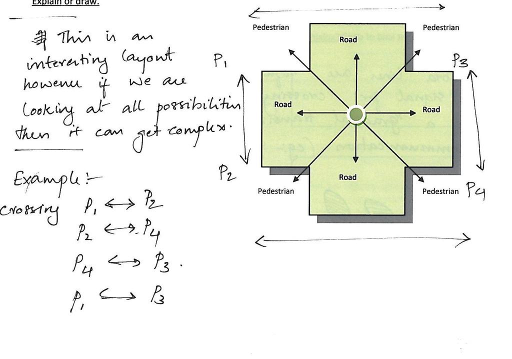
18 Image 18 Information spreed to the users 5. Analys and problem determinasion With more and more roads to satisfy the needs and prevent traffic jams, more traffic lights and signs will be needed, when that does not work anymore polices have to control the traffic flow. When more traffic lights and signs are installed one significant problem appears, the information within the intersection increases which might lead to confusion from the user. It is important to receive the information needed when using an intersection, but when more information is given the user has to determent what to use. If wrong choice is made, fatal accidents might occur. This appears when the human facture is involved. When population grows, traffic increases which will lead to traffic jams if not prevented. This is a problem in cities around the world. Problem with today s traffic application is that they are all based on old data, which doesn t prevent users from getting stuck in traffic jams (image 33). Cyclists are a vulnerable group in traffic situations. Their speed and lack of protection is a bad combination. They are often using the lane between the vehicle and the pedestrian, which often is on the road. They have a hard time communicating with other participants. Vehicles that are, as cyclists, using the roads have more ways to communicate their actions, break lights and direction flashers Pedestrians are often not focusing on their surroundings. This was discovered in the documentation process. By looking at the ground or facing straight ahead it is hard to spot physical threats, such as vehicles when crossing the road. The drivers on the road have various things to pay attention to (image 19, 20). They have to Image 19 Describing the information flow at a 4-way intersection Image 20 Describing the information flow at a 6-way intersection 17

19 focus on the traffic light signaling for stop and go in their way. When certain turns are made and the driver has a green light they still have to pay attention to pedestrians who have the righter way to cross. In addition to this they have to be observant of signs telling them about exceptions or other regulations for that specific intersection. Image 21 Describing the human factor at a 6-way intersection When chaos strikes a vulnerable traffic police is placed in the middle of it all. It is an effective method to control the flow and restore order. The human factor will be involved which is a major problem because the main reason why traffic lights were installed was to eliminate it (image 21). 18


. This would lead to a system that is controlled by its users. police to signal. Today the signals for stop and go are done with their hands.")
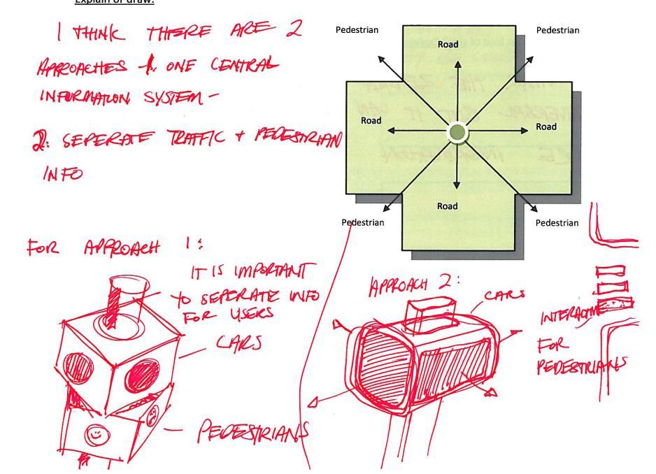
20 Image 22 Illustrates the centralization of information at a 6-way intersection 6. Solution The two problems are information overload and traffic jams. As discussed there are different solutions with today s technology but most of them are based on information collected from the past and not from the present. If data could be collected from the present it could be analyzed and determined, and a solution can be delivered for operation. By receiving information from present data a precise result is established, but this doesn t solve everything, it is one step closer to the solution but still carries the human factor. By giving data to a central system that carries an algorithm which will calculate the data input from all the users and give direction to the users based on the information that where given (image 22). This would lead to a system that is controlled by its users. police to signal. Today the signals for stop and go are done with their hands. Signal for stop is a raised hand with the palm facing the driver. Go is signaled with the front of the hand facing the driver and waving in the direction to go. This glove would with help from colors make the signals more clear. The glove would be colored red on the palm side to add to the message stop. The front or up side of the glove would be colored green to clarify the message go. Today the help the traffic police have is an orange colored stick to wave with to get extra attention. The other purpose could be for cyclist to communicate and make it easier for participants to avoid misunderstandings. By develop communication possibilities for cyclists their safety will increase. The glove would work as device to signal with when stopping and turning. Image 24 Crossing with warning text Image 23 Gloves to signal with The first solution was a glove with multiple purposes (image 23). One is helping traffic The second solution was for the pedestrians (image 24). The documentation videos show that pedestrians often look in to ground when they cross the street and not in their surroundings to better see possible threats. The idea was to write a message in the white zebra lines like look up to get the pedestrians to better pay attention. The third solution focused on centralization. The main purpose is to slim down the 19

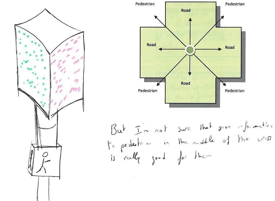
21 information flow so that the user only get the information needed and do not get distracted by information directed to others. The centralization is brought out both technically and in physical design. Physically because the signals will be brought together in to the same device signaling from the middle of the intersection (image 25). Technically because the system regulation and controlling traffic will be adapted after the users and also include communication with the traffic light. Image 25 Centralized traffic light 20
22 7. Solution determination Looking at the introduction the project had the goal to create a solution that would start a new way of thinking for the future. The third solution would best accomplish this. Working with this type of centralization (image 26) means that a lot of smaller changes can be made but together make a big difference. If the project was to move forward with the whole solution could be implemented or just parts of it. So by creating a product that is oriented to deliver only the necessary information to the user information overload is eliminated. Image 26 The user controls the system A system that would be controlled by users was discussed in chapter 7, if a centralized traffic device would be connected to the system (image 22) it will be possible for the device to make decisions depending on the information that the system carries. 21
23 8. Specification Since the project does not go deep in to the subject of traffic communication neither does the specification for the chosen solution. The first requirement was also one of the main thoughts of the solution. That is to decrease the information flow and only give the information needed to that specific user. The second solution brings in the personas and the variety between them. Everyone, even with one disability, should be able to use and cross the intersection. The starting point of everyone is the personas and these fictive persons should have solutions within the intersection that are to their benefit. The third requirement is to bring the three subjects nature, safety and technology in to the solution in some way. 22


.")


24 9. Solution development After the third solution was chosen the hypothesis of centralization was tested by building mock ups. The mock ups showed different shapes, colors and transitions in a three dimensional way. One of the mock ups was testes in a real intersection to see if one device signaling to both pedestrians and drivers would work. Another thing was to see if color and blinders would work from distance. After the test was done different designs of the signaling device was tried out. They were all placed in a neutral city environment to see how they would fit in but still focus on the product and not the surroundings (image 26-35). Image 27 Image 28 Image 29 Centralization Centralization 2 Centralization 3 Image 30 Image 31 Image 32 Centralization 4 Centralization 5 Centralization 6 Image 26 Centralize the communication information Image 33 Image 34 Image 35 Centralization 7 Centralization 8 Centralization 9 23


. Trees and green plants will create a calmer atmosphere both with the sound reduction and leafy frame around the intersection.")
25 10. Final solution and evaluation The final solution is presented in a CAD environment showing solutions to fulfill different needs. Going through the three key words nature, safety and technology they have been implemented in different ways. thought is that the user connects to a network and puts in information. The system processes the information together with the rest of the in data from other users. With help from an algorithm an output from the system is given back to the user as well as the traffic light so that the traffic and communication flow is optimized. This will be illustrated by a few Image 36 Image 37 Overview of the intersection where information is centralized Supension of the device Nature is integrated in the environment that builds the intersection (image 36). Trees and green plants will create a calmer atmosphere both with the sound reduction and leafy frame around the intersection. In the roundabout there will also be plants to calm traffic down and actually putting living matter there will add to the feeling of having to be cautious. Technology comes in both a system and Image 36 physical way. The attachment of the signal device can be done in many different ways. No specific solution for this is chosen but there is a wish to integrate nature (image 37). To illustrate this, the device is placed in the intersection by attachment to one of the trees. Technology also plays a part in the system controlling the signals in the intersection. The change here is that the system is adapted after the user and not vice versa. The basic examples. Safety has been looked after over all in creating a calmer environment but especially when it comes to emergency vehicles. As said before there are systems to help emergency vehicles get the righter way. Here this is taken one step further by including the drivers in the intersection as well. The lane that has the emergency vehicle coming from behind will get a warning signal so they know to move a side in head of time (image 38). The signal is a Image 38 Describes how it looks for the user when emergency vehicle coming up from behind 24

26 blue frame around the red square resembling with the blue flashing lights from a ambulance, fire truck or police car. The other lanes will just get a regular red light to stop since they do not have to get out of the way to bring all systems that today are separated together to centralize it all. One source that gets all the input and gives all the output. Example A A driver in a car wants to get from A to B during rush hour. She gives this input to the system and the system responds back with a suggested route. Since the system has information from so many other users it is able to determine the best way to take. The shortest distance on the map is usually the most crowded one. So what the system does is trying to spread out its users to avoid congestions. The driver gets one route suggestion from A to B, another user with the same start and final destination might get another route. Example B A pedestrian using a wheelchair is heading towards a crossing. This pedestrian has by e.g. prescription from a doctor been able to add to the system that a wheelchair is in use. This is signaled by some kind of device to the specific traffic light he is heading to. When the wheelchair user gets a green light and is crossing the green light will stay for a longer time in order for the wheelchair user to get enough time to cross. Example C Many vehicles are travelling on the same road. Since they are all logged on to the same system the system will know that this specific road is starting to get backed up. A message is sent to the traffic light to give a green light in that direction to get traffic to flow better and ease the congestion. Example A and C already exists in some form in specific cities or as apps. The point here is Image 39 Pedestrian view The changes for the pedestrian are the signal device and zebra lines in the cross path. The light device signaling has a geometry and is places so that only the pedestrian about to cross the street from that direction can see the signal (image 39). A green person walking and a red person standing still are used as symbols as they are so common trough out the world. A speaker on the pole gives information when to cross or not through specific sounds. The white zebra lines have been narrowed off in the end closest to direction of where the vehicles are approaching (image 39). This to in an intuitive way to point in the direction to look when crossing that side of the street. The bricks that give tactile information that already have been installed in Chicago are taken one step forward (image 40). Now the whole corner is marked out and at the corner spot a rising have been done to prevent pedestrians to cross the intersection diagonally. The place where to enter the crossing slopes to make it easier for elderly or for example strollers. 25


.")


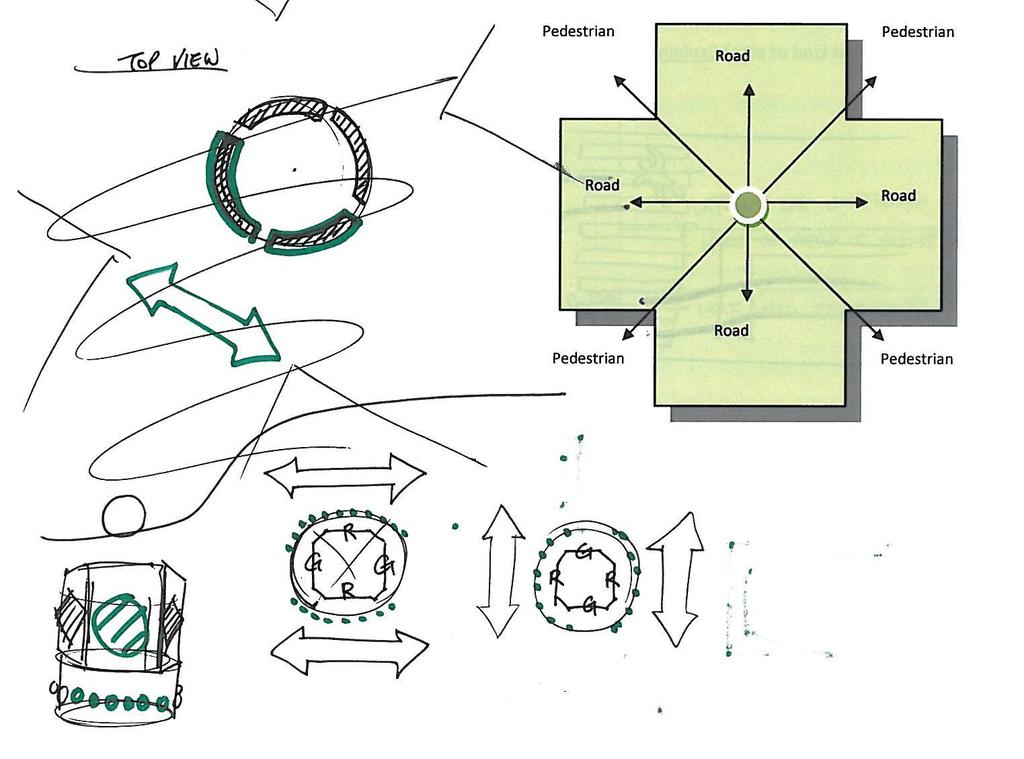
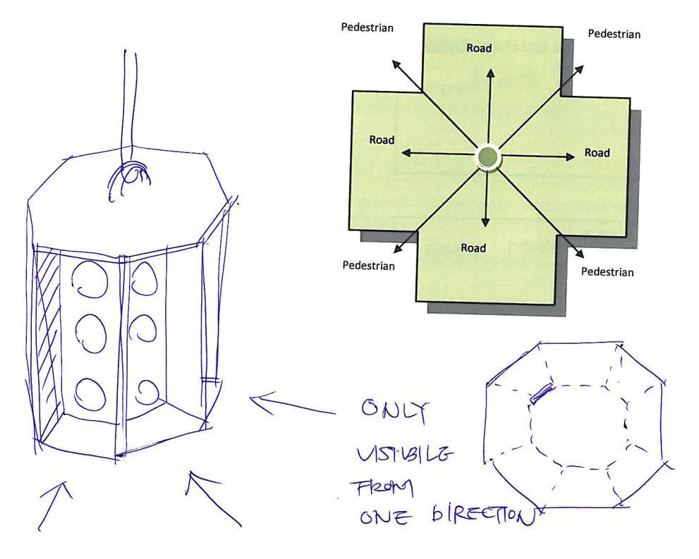
27 For the drivers three changes have been made. Roundabouts are placed in the middle of the intersection so that the driver has to change the direction of the vehicle and indirect slow down the speed (image 41). When approaching a crossing for the pedestrians the white zebra lines have a triangle like shape and resemble with the cautions triangle that sometimes is painted on the roads in Sweden. The device signaling to the drivers is places in the middle of the intersection and only one device is signaling to all four directions. The signals are sent out from a display that also can be programmed to send out other messages like road closed (image 42) and similar. The signals go is a green circle and for stop a red square (image 43/44). The amber light for wait/caution has been removed and to indicate the switch between red and green there is an animated transition. The green light comes on and after a certain time the green starts to sink as a n indication that the signal is about to turn to red. This way the amount of signal is reduced. The new traffic light signals in all directions in the intersection and the signals are separated by screens to ensure that the user only gets one message (image 45). The top of the traffic light has solar cells that power a street light that comes up out of the traffic light. The thought is that the traffic light should be selfpowered to some extent and use nature as a source of energy. Image 40 Bumps for tactile interaction Image 41 Illustrates how roandabout chamles the traffic flow Image 42 Device and its functions Image 43 Image 44 Stop Go 26 Image 45 Users approsh
28 11. Discussion By information overload the system will break down when it continues to expand, which it does. It is important not to lose focus why we communicate with in traffic situations and why it all began. When traffic lights first where installed vehicle users where a small group. The population within the areas they are used is growing and the users are getting more and more. The information within these areas is already too much and as a user you need to define which information is directed to you. This is a step back, when traffic lights first where installed it was to prevent users to misunderstand each other, delete the human factor and restore order. If confusion is created something got measured up with in the population growing. Today s traffic lights aren t developed to handle the amount of users it is exposed to. So by going back to the roots, we can agree on that by communicating information should be handed out and as a user you only need the information that s actually concerns you. So by partitioning the information it will delete the human factor and decrease the risks of misunderstanding. Using an algorithm in a centralized system helps spreading the traffic flow. They main reason to take this direction is to prevent traffic jams. The inspiration is picked up from ants, who are using this system when working. By communicate and using an algorithm they keep the traffic flowing. So by giving this system to users within the traffic environment they can work together. The systems output will be based on the in data from users and from there it will control traffic lights depending on needs. If every interpreter is involved, the system with its devices, will be a very strong tool to plan the cities logistics. The human has its limitations and that has to be thought of whenever developing something for a user. In this project one of the main focus point has been to slim down the system, as a consideration to the human limitations. But the human mind is complex and caution always has to be taken. Making something well advanced as a traffic system too simple for its users may get the opposite effect. The users might trust the system too much or feel a lack of control over their own situation, and cause even more danger than before. The psychological aspect always, and especially in traffic situations, has to be taken in consideration. Unfortunately this project does not go in to the problem deep enough to do this. Advanced products and systems have to, as mentioned in the theory chapter, be constructed for failure. In particular widely spread and fundamental products and system that society relies on. Looking back in history to many incidents has happened where the complexity causes more panic and confusion then eases troubles for operators. As said before this projects hopes to set a direction for future thinking. We understand that the concept presented still has a lot of questions to answer and that such new thoughts will take time to be accepted and understood. The project is handling a very diverse subject and does not go deep in to details or a solution as said before. Working with an industrial design firm focus was more on the design process than engineer based tangible solutions. It has been a great experience learning to trust a process not knowing the final end result from the beginning as often is known in design projects. This experience can still be very useful in more technical projects as various and different methods to investigate and evaluate always is useful and brings in another dimension as well. The solution presented might sometimes feel a bit far of or hard to relate to reality, but hope has been from the start to set a direction 27
29 for a new way of thinking. It was early realized that an implementable solution was impossible to create in eight weeks. To do that the projects must be very precise from the beginning and few projects are. 28
30 References Books Teknisk psykologi, Mats Danielsson, 2001 Bokförlaget Natur och Kultur, Stockholm Images n_signal_timers_will_l.html Tables Table 1- Statistics of International traffic accidents 2007, IRTAD - Olycksstatistik/Vag/Internationell-statistik/ Websites 6/john_peake_knight_traffic_lights_feature.shtml Sidor/trafiksignaler.aspx pticomp.htm n/naturistadenhurforvemochtillvad f412e262f9f0c html
31 Appendix 1/1 Survey Traffic Light Project Today s communication system for intersections has many ways to give information. Signs, lights, sound and symbols control the traffic flow. As a pedestrian or driver interacting in this environment you are given a lot of information at the same time, sometimes even information that does not even concern you. As cities grow the traffic net and roads expand. Added is more and more information in order to keep everyone safe and traffic to move smooth. There is a Swedish saying that goes you can t see the woods because of all the trees. The same with the traffic signals, sometimes they are so many you miss them as you are trying to stay with the traffic rhythm. What if there was a way to centralize it all so that you only get the information you need at that specific moment? What if we all use the same source in our communication? What if there was only one thing signaling to all of us? With technology like wireless communication and open source we think the future is headed that way. Traffic accidents are one of the most common causes of death for children. Is there a way to make the road safer and drivers calmer? What makes us feel at ease and in harmony? Would that be knowing what s going on, not having to wait? And when we do, knowing when the wait is over? Is grey and dull concrete and bricks what make us feel calm or are colorful trees and plants a better environment? What the traffic light project has resulted in is the development of a centralized traffic light that communicates with everyone in the intersection. Our hope is to decrease unnecessary information, integrate the drivers actions with the traffic lights for more accurate information and create a safer environment on the road. Following questions concern the design of a centralized traffic light to make it and the system it will have as optimal as possible.
 IIIII Good: simple words Bad: confusing, text for drivers too?")
32 The cross path Survey Would a message integrated with the lines be disturbing I useful IIIII I Which of following would be most appropriate? (Mark as many as needed). Depends II (clear message, execution) IIIII Good: simple words Bad: confusing, text for drivers too? not enough specific, fuc I make font relective Bit confusing, like experiment confusing, too late in middle of street, confusing I Good with arrow, info given before you cross Bit confusing, like experiment too much info, too busy

33 IIII pretty good I Like symbol, One graphic to both ped and drivers? cool, too vauge, not clear enough, sign better international, evil eye Would you rather have another indication for a cross path then zebra lines? Yes I Maybe IIII No IIII If so which what kind of sign? Explain and draw. Zebra, universally accepted, could be updated with more info
34
35 The traffic light What do you think of the idea of a traffic light signaling to both pedestrians and drivers? Comment: Confusing Good: flow smoother? Ped driver status check at same time, needs distinctive visual signs. Have idea in france, trust in no confusion? Good: effective communication, avoid confusion and impulse decisions. Hard to match viewing angle Good if executed well Smart one leader voice Good clear direct info Two light drivers one direction, ped. Another Like idea but info overload? Like it! Do you think it is useful or unnecessary to see information given to others in an intersection when it comes to traffic signals? Comment: Unnecessary, only need stop or go for self. Could be useful to see both, prioritizing them? Unnecessary Unnecessary, too much to think about Depending on space, will see reaction anyway. Sometimes useful Distracting dangerous Can be useful, but more info then needed could also be dangerous.


36 Useful like countdown Only to see ped signals Useful! Not useful? For a simple intersection of two roads crossing each other, what basic shape for the traffic light do you think is most suitable? Communication is to be given in eight directions. Explain or draw.
37
38
39


")

 I I")


40 Which symbols do you think are best signaling stop-go for drivers and stop-go for pedestrians? IIIII I II Stop square? II Pointing up? II (with extra line like play) II Confusing IIII (language issue) IIIII I like stripes II Red circle, I sad face III more to ban then stop I III IIIII I II I I Caution not stop?
CITY OF SAINT JOHN TRAFFIC CALMING POLICY
 CITY OF SAINT JOHN TRAFFIC CALMING POLICY VERSION: 1.0 April 10, 2012 Pedestrians, Cyclists and Motorists Sharing Street Spaces CONTENTS INTRODUCTION... 3 POLICY GOAL... 3 POLICY OBJECTIVES... 3 GUIDING
Tonight is for you. Learn everything you can. Share all your ideas.
 Strathcona Neighbourhood Renewal Draft Concept Design Tonight is for you. Learn everything you can. Share all your ideas. What is Neighbourhood Renewal? Creating a design with you for your neighbourhood.
TRANSPORTATION STUDY REPORT DRAFT - APRIL 2015 A BLUEPRINT FOR HOW WE CAN GET AROUND GREATER SUDBURY, FROM NOW UNTIL 2031
 TRANSPORTATION STUDY REPORT DRAFT - APRIL 2015 A BLUEPRINT FOR HOW WE CAN GET AROUND GREATER SUDBURY, FROM NOW UNTIL 2031 A summary of what s there, what more is needed, how to find information about your
Walk This Way. Red Colour Group- Intermediate
 Walk This Way Activity Overview: Students will learn how to cross the road safely, from the basics of pedestrian signals to the importance of using pedestrian push buttons, avoiding distractions, being
A CHANCE TO RIDE. Lesson 3 Pedestrian Safety & Awareness of Surroundings
 A CHANCE TO RIDE Lesson 3 Pedestrian Safety & Awareness of Surroundings Introduction Pedestrian Safety & Awareness of Surroundings Techniques of pedestrian travel including safe street crossing need to
CHAPTER 3: Vision Statement and Goals
 Davidson Walks & Rolls: Active Transportation Master Plan CHAPTER 3 Contents: Overview Vision Statement Measurable Goals Public Outreach CHAPTER 3: Vision Statement and Goals Overview The vision statement
Beginning School Bus Driver Curriculum UNIT IX. FIELD TRIPS and TRAFFIC CONTROL DEVICES. Revised 09/2011 Revised 10/2013 (Instructional Content)
") Beginning School Bus Driver Curriculum UNIT IX FIELD TRIPS and TRAFFIC CONTROL DEVICES Revised 09/2011 Revised 10/2013 (Instructional Content) Unit IX FIELD TRIPS AND TRAFFIC CONTROL DEVICES TABLE OF CONTENTS
Beginning School Bus Driver Curriculum UNIT IX FIELD TRIPS and TRAFFIC CONTROL DEVICES Revised 09/2011 Revised 10/2013 (Instructional Content) Unit IX FIELD TRIPS AND TRAFFIC CONTROL DEVICES TABLE OF CONTENTS
Pedestrian Crosswalk Audit
 1200, Scotia Place, Tower 1 10060 Jasper Avenue Edmonton, Alberta T5J 3R8 edmonton.ca/auditor Pedestrian Crosswalk Audit June 19, 2017 The conducted this project in accordance with the International Standards
Road design and Safety philosophy, 1 st Draft
 Head Office SWEDEN www.vv.se Textphone: +46 243-750 90 Roger Johansson International Secretariat roger.johansson@vv.se Direct: +46 243 75880 Mobile: +46 70 6327373 Date: 2006-08-17 Reference: Road design
COLLISION AVOIDANCE SYSTEM FOR BUSES, MANAGING PEDESTRIAN DETECTION AND ALERTS NEAR BUS STOPS
 COLLISION AVOIDANCE SYSTEM FOR BUSES, MANAGING PEDESTRIAN DETECTION AND ALERTS NEAR BUS STOPS Benjamin Englander Michael Cacic Cheikh Diop Rosco Collision Avoidance, Inc. United States of America Yaniv
Road Safety. Inspections
 Title of your presentation Road Safety Name and contact details Inspections Phil Allan Australiaame ROAD SAFETY SEMINAR Lome, Togo October 2006 Definition A Road Safety Inspection (RSI) is an on-site systematic
Why Zone In on Speed Reduction?
 Learn it. Do it. Live it! SPEED REDUCTION IN THE ZONE Why Zone In on Speed Reduction? Speeding is a serious issue that plays a major role in the risk of serious injury and pedestrian fatality in a crash.
City of Elizabeth City Neighborhood Traffic Calming Policy and Guidelines
 City of Elizabeth City Neighborhood Traffic Calming Policy and Guidelines I. Purpose: The City of Elizabeth City is committed to ensure the overall safety and livability of residential neighborhoods. One
Film Guide for Educators. Designing for Safety
 Film Guide for Educators Designing for Safety Designing For Safety Key Concepts Speeding While Driving Speeding is the number one cause of injuries and deaths from driving. The main reasons are because
Broad Street Bicycle Boulevard Design Guidelines
 Broad Street Bicycle Boulevard Design Guidelines Building from the strategies introduced in the 2013 Bicycle Transportation Plan and community input received thus far, City Transportation Staff have identified
Traffic Signs and Signals
 CHAPTER FOUR Traffic Signs and Signals Traffic signs control traffic flow, making streets and highways safer for drivers, bicyclists and pedestrians. These signs, which are posted by the Indiana Department
THE OFFICIAL GUIDE TO CYCLING SAFELY IN PHILADELPHIA
 B IKE NICE THE OFFICIAL GUIDE TO CYCLING SAFELY IN PHILADELPHIA A partnership of the City of Philadelphia and the Bicycle Coalition of Greater Philadelphia ABOUT VISION ZERO & BIKE NICE It s a great day
Everyday Hazards for School Bus Drivers. Reference Guide and Test
 1 Everyday Hazards for School Bus Drivers Reference Guide and Test 2 Introduction One of the most important and often overlooked issues for school bus drivers is hazards. During the course of the video,
HUMAN (DRIVER) ERRORS
 ERRORS") HUMAN (DRIVER) ERRORS Josef Kocourek 1, Tomáš Padělek 2 Summary: Currently CTU FTS creates Road Safety Inspection (RSI) in Central Bohemia region. The survey is specialized in roads of class II. This article
HUMAN (DRIVER) ERRORS Josef Kocourek 1, Tomáš Padělek 2 Summary: Currently CTU FTS creates Road Safety Inspection (RSI) in Central Bohemia region. The survey is specialized in roads of class II. This article
City of Novi Non-Motorized Master Plan 2011 Executive Summary
 City of Novi Non-Motorized Master Plan 2011 Executive Summary Prepared by: February 28, 2011 Why Plan? Encouraging healthy, active lifestyles through pathway and sidewalk connectivity has been a focus
Literature Review: Final
 Jonathan Sigel Section A December 19 th, 2016 Literature Review: Final Function and Purpose of a Roundabout: Roundabouts are a location in which multiple roads are joined together in a circle, with an
Chapter 5. Complete Streets and Walkable Communities.
 Chapter 5. Complete Streets and Walkable Communities. 5.1 Description of Complete Streets. Cities throughout the world, and specifically the United States, are coming to embrace a new transportation and
Group Riding Tips. Planning the Ride
 Group Riding Tips There are a number of factors that come into play when planning or participating in a group ride. Here are some suggestions for making your rides safe and successful. Planning the Ride
Chapter #4 Traffic Control Devices and Laws
 Chapter #4 Traffic Control Devices and Laws Chapter #4 Overview Unit 4 will introduce the student to traffic control devices, including signs, signals and pavement markings, as well as traffic laws specific
Florida Class E Knowledge Exam Road Rules Practice Questions
 1. If you are being followed too closely while driving, you should: A. Drive closer to the car in front of you. B. Speed up to increase the distance between you and the following vehicle. C. Slow down
Golf. By Matthew Cooke. Game Like Training
 Game Like Training for Golf By Matthew Cooke Game Like Training @gltgolf @gltraininggolf Introduction In this quick start guide we dive a little deeper into what it means to train in a Game Like way. Game
Crosswalk event overview (Saint Paul) How to organize a crosswalk event. 1. Choose a date, time and location
 How to organize a crosswalk event. 1. Choose a date, time and location") Crosswalk event overview (Saint Paul) A crosswalk event occurs when an individual or group of individuals promote pedestrian safety by demonstrating the proper use of a crosswalk. During the event, a group
Crosswalk event overview (Saint Paul) A crosswalk event occurs when an individual or group of individuals promote pedestrian safety by demonstrating the proper use of a crosswalk. During the event, a group
Unit Six: Driving Faster with More Risk URBAN, SUBURBAN, AND RURAL DRIVING
 Unit Six: Driving Faster with More Risk URBAN, SUBURBAN, AND RURAL DRIVING What Is The Impact Of Distraction? Objectives For Unit Six Students will be able to describe the skills necessary to What safely
Ann Arbor Downtown Street Plan
 1 Ann Arbor Downtown Street Plan Public Workshop #1 We know that. 2 Public right-of-way (streets, sidewalks, and alleys) make up 30% of the total District area of downtown. Streets need to provide mobility
RIGHT-OF-WAY INTERSECTIONS
 Infrastructure Give Cycling a Push INFRASTRUCTURE/ INTERSECTSIONS AND CROSSINGS RIGHT-OF-WAY INTERSECTIONS Overview Right-of-way mixed traffic is the simplest, most agreeable approach for cyclists on quiet
PLACEMENT OF SIGNS RECOMMENDED PRACTICES SUB-SECTION
 Page 1 of 6 RECOMMENDED PRACTICES PART SECTION SUB-SECTION HIGHWAY SIGNS GENERAL General Proper positioning of signs is an important element in the overall control of traffic within a roadway network.
Vermont Permit Test Flash Cards
 Vermont Permit Test Flash Cards Study online at quizlet.com/_aormb are the most likely places for car and motorcycle collisions to occur. intersections are areas around trucks where cars disappear 2. :
EMPHASIS AREA 1: PEDESTRIANS
 EMPHASIS AREA 1: PEDESTRIANS A pedestrian is seriously injured or killed every 3 days on Toronto s roads. Pedestrian collisions involve any person that is not riding in a vehicle or on a bicycle. 26% OF
City of Toronto Complete Streets Guidelines
 Round One This is a summary of the Complete Streets Guidelines Survey posted on June 18 th, 2015 and live until July 2 nd, 2015. The survey was designed to solicit feedback on the draft Complete Streets
Basic organization of the training field
 Burke Athletic Club u4 & 5 Training Scheme Phase I Introduction to Soccer 1v1 Legend The purpose of this training program is to allow the u4 and 5 s the opportunity to learn some basic ideas and experience
Pedestrian and School Bus Safety TEACHING GUIDE ( DVD included)
") Pedestrian and School Bus Safety TEACHING GUIDE ( DVD included) TEACHING GUIDE Pedestrian and School Bus Safety Project manager Diane Godbout Production manager Nathalie Cazeau Road safety advisor Jacqueline
Pedestrian and School Bus Safety TEACHING GUIDE ( DVD included) TEACHING GUIDE Pedestrian and School Bus Safety Project manager Diane Godbout Production manager Nathalie Cazeau Road safety advisor Jacqueline
Soft measures affect traffic in Lund effects from two years work with a sustainable transport system in Lund
 Soft measures affect traffic in Lund effects from two years work with a sustainable transport system in Lund Speaker: Pernilla Hyllenius, Trivector Traffic AB, Lund, Sweden pernilla.hyllenius@trivector.se,
DYNAMIC LANES FOR AUCKLAND
 Dynamic Lanes for Auckland MENEZES M. and INMAN R. Page 1 DYNAMIC LANES FOR AUCKLAND Authors: INMAN, Robert BA (Hons) Previously Auckland Transport Senior Traffic Engineer Now Aurecon Robert.Inman@aurecongroup.com
Government Accelerators
 Government Accelerators Reduction in the number of road s fatalities in the UAE United Arab Emirates Presented By: Ministry Of Infrastructure Development Statistics - Roads` accidents and fatalities
Identify the letter of the choice that best completes the statement or answers the question.
 Chapter 02 - Practice Questions Multiple Choice Identify the letter of the choice that best completes the statement or answers the question. 1) No-parking zones often are near a. fire hydrants, curves,
MOBILEYE SHIELD + COLLISION AVOIDANCE SYSTEM OUR VISION. YOUR SAFETY.
 MOBILEYE SHIELD + COLLISION AVOIDANCE SYSTEM OUR VISION. YOUR SAFETY. MOBILEYE SHIELD + OUR SOLUTION FOR PEDESTRIAN & CYCLIST SAFETY The Mobileye Shield+ System is the latest technological advancement
2nd Grade: PEDESTRIAN SAFETY UNIT
 2nd Grade: PEDESTRIAN SAFETY UNIT SAFE STREET CROSSING is the first class we offer addressing road safety and transportation choices. 2nd grade: Pedestrian Safety Unit 4th grade: Three-part Bicycle Safety
TRAFFIC CALMING TOOLBOX. For the residents of the City of Decatur, Georgia
 TRAFFIC CALMING TOOLBOX For the residents of the City of Decatur, Georgia 2 City of Decatur Traffic Calming Toolbox Public Works Department 2635 Talley Street Decatur, GA 30030 404.377.5571 3 Welcome to
Task 4 Wayfinding Elements, Placement and Technical Guidance 4.1 Wayfinding Elements
 1836 Blake Street Denver, CO 80202 720.524.7831 ww.altaplanning.com MEMO 3 Task 4 Wayfinding Elements, Placement and Technical Guidance 4.1 Wayfinding Elements Based on field reconnaissance, best practices
Proposed. City of Grand Junction Complete Streets Policy. Exhibit 10
 Proposed City of Grand Junction Complete Streets Policy Exhibit 10 1 City of Grand Junction Complete Streets Policy Vision: The Complete Streets Vision is to develop a safe, efficient, and reliable travel
PEDESTRIAN ACTION PLAN
 ATTACHMENT 2 CITY OF SANTA MONICA PEDESTRIAN ACTION PLAN CITY OF SANTA MONICA PEDESTRIAN ACTION PLAN This page intentionally left blank EXECUTIVE SUMMARY CHAPTER 1 EXECUTIVE SUMMARY Setting the Stage
Position Paper on Accessible Roundabouts
 Position Paper on Accessible Roundabouts June 2012 This research based document outlines essential elements in the design of roundabouts, to make them accessible for all pedestrians, including those who
California DMV Test. Mark the correct answers
 California DMV Test Mark the correct answers 1. When you leave your lane to pass another vehicle, you know you have enough room to return to your driving lane when you: Have passed the other vehicle's
VILNIUS SUMP. Gintarė Krušinskaitė International project manager place your logo here
 VILNIUS SUMP Gintarė Krušinskaitė International project manager Gintare.krusinskaite@vilniustransport.lt place your logo here 19 April, 2017 WHERE DID WE CAME FROM? Mobility management and mobility planning
DOI /HORIZONS.B P23 UDC : (497.11) PEDESTRIAN CROSSING BEHAVIOUR AT UNSIGNALIZED CROSSINGS 1
 PEDESTRIAN CROSSING BEHAVIOUR AT UNSIGNALIZED CROSSINGS 1") DOI 10.20544/HORIZONS.B.03.1.16.P23 UDC 656.142.054:159.922(497.11) PEDESTRIAN CROSSING BEHAVIOUR AT UNSIGNALIZED CROSSINGS 1 JelenaMitrovićSimić 1, Valentina Basarić, VukBogdanović Department of Traffic
DOI 10.20544/HORIZONS.B.03.1.16.P23 UDC 656.142.054:159.922(497.11) PEDESTRIAN CROSSING BEHAVIOUR AT UNSIGNALIZED CROSSINGS 1 JelenaMitrovićSimić 1, Valentina Basarić, VukBogdanović Department of Traffic
Identify the letter of the choice that best completes the statement or answers the question.
 Chapter 10 - Practice Questions Multiple Choice Identify the letter of the choice that best completes the statement or answers the question. 1) Before passing a vehicle in your lane, a. anticipate the
Agenda. Overview PRINCE GEORGE S PLAZA METRO AREA PEDESTRIAN PLAN
 PRINCE GEORGE S PLAZA METRO AREA PEDESTRIAN PLAN May 28, 2008 Agenda Welcome and introductions Project overview and issue identification Planning context and strengths Design challenges and initial recommendations
GIS Based Non-Motorized Transportation Planning APA Ohio Statewide Planning Conference. GIS Assisted Non-Motorized Transportation Planning
 The Purpose of GIS Assisted Network GIS Assisted Non-Motorized Transportation 2011 APA Ohio Statewide Conference Friday, 10:45 AM to Noon Focus on near-term projects wwwgreenwaycollabcom The purpose of
Report on MEPS Přerov TH MIDDLE EUROPEAN PROJECT SEMINAR LAURA ENJUANES NOGUERO E
 2017 Report on MEPS Přerov 2017 28TH MIDDLE EUROPEAN PROJECT SEMINAR LAURA ENJUANES NOGUERO E01650478 Table of Content 1. Introduction... 1 2. Problem definition... 1 3. Proposed solution in the presentation...
Transportation Master Plan Advisory Task Force
 Transportation Master Plan Advisory Task Force Network Alternatives & Phasing Strategy February 2016 BACKGROUND Table of Contents BACKGROUND Purpose & Introduction 2 Linking the TMP to Key Council Approved
Governance and Priorities Committee Report For the July 2, 2015 Meeting
 CITY OF VICTORIA For the July 2, 2015 Meeting To: Governance and Priorities Committee Date: From: Subject: Brad Dellebuur, A/Assistant Director, Transportation and Parking Services Executive Summary The
MODULE 2: Stop, Look, Listen, Think
 Foundation, Levels 1 and 2 MODULE 2: Stop, Look, Listen, Think Activities Learning to Stop, Look, Listen, Think Links to AusVELS Foundation Level Health and Physical Education Movement and physical activity
Summary of Comments Public Meeting: Marietta Street Resurfacing Project Atlanta Contemporary August 29, 2017 / 6:00 pm to 8:00 pm
 Renew Atlanta hosted a public meeting to discuss the Marietta Street Resurfacing project at. Councilmember Cleta Winslow attended the public meeting, where over seventy (70) citizens to include representatives
Lesson 2: Crossing Streets Safely
 Time: approximately 40 minutes Lesson 2: Crossing Streets Safely LESSON PLAN: Lesson 2 This curriculum does not cover every possible scenario that a child may encounter as a pedestrian, but instead addresses
Transportation Assessment
 Transportation Assessment Midtown Open House February 10, 2018 Overview Midtown in Focus Overview & Purpose of Today Transportation Assessment overview Summary of Transportation work to date Review & Analysis
Southern California Walking/Biking Research And Creative Evaluation
 Southern California Walking/Biking Research And Creative Evaluation Quantitative Research Topline Report December 7, 2015 Background & Objectives The Southern California Association of Governments (SCAG)
Signs. signs, signals and road markings. in this chapter
 3 signs, signals and road markings in this chapter Signs regulatory signs school, playground and crosswalk signs lane use signs turn control signs parking signs reserved lane signs warning signs object
Department of Transportation
 Department of Transportation I. Internal Scan The number of older drivers in the United States will double over the next 30 years. By 2030 one in five Americans will be age 65 or older. On a licensed-driver
ROUNDABOUTS/TRAFFIC CIRCLES
 GENERAL 1. Description This standard identifies minimum requirements that shall be met for Roundabouts and Neighborhood Traffic Circles in the design and construction of elements for Arlington County Horizontal
MOBILEYE SHIELD+ COLLISION AVOIDANCE SYSTEM
 MOBILEYE SHIELD+ COLLISION AVOIDANCE SYSTEM MOBILEYE SHIELD + OUR SOLUTION FOR PEDESTRIAN & CYCLIST SAFETY The Mobileye Shield+ System is the latest technological advancement for preventing collisions
INDEX. Geometric Design Guide for Canadian Roads INDEX
 Acceleration lane, see Lanes, Acceleration Access, 8.1 Access Management and Functional Classification 8.2 Access Management by Design Classification 8.3 Access Configuration 8.4 Building Set-Back Guidelines
PEDALING FORWARD. A Glance at the SFMTA s Bike Program for SFMTA.COM
 PEDALING FORWARD A Glance at the SFMTA s Bike Program for 2017-2021 SFMTA.COM INTRODUCTION About This Booklet More people from all walks of life see their bicycle as a more convenient way to get where
LECTUR 10 CHARACTERISTICS OF THE DRIVER, THE PEDESTRIAN, THE VEHICLE AND THE ROAD. One problem that faces traffic and transportation engineers is:
 LECTUR 10 CHARACTERISTICS OF THE DRIVER, THE PEDESTRIAN, THE VEHICLE AND THE ROAD 3.1 DRIVER CHARACTERISTICS Physiological Measurable and Usually Quantifiable Psychological Much more difficult to measure
A CHANCE TO RIDE. Lesson 2 Signs & Traffic Symbols
 A CHANCE TO RIDE Lesson 2 Signs & Traffic Symbols Introduction Signs & Traffic Symbols Signs and traffic symbols are the primary way that safety information is communicated to a large number of individuals.
Monroe Street Reconstruction Business Focus Group Notes July 18, 2016, HotelRED
 Monroe Street Reconstruction Business Focus Group Notes July 18, 2016, HotelRED Total participants: 31 Focus Group Conversation #1: During this exercise, participants talked in small table groups in response
TRAVEL PLAN: CENTRAL EUROPEAN UNIVERSITY CAMPUS REDEVELOPMENT PROJECT TRAVEL PLAN. Central European University Campus Redevelopment Project.
 TRAVEL PLAN Central European University Campus Redevelopment Project Page 1 Table of Contents Introduction... 3 Background... 7 Building Users... 7 Transportation in Community Consultation... 7 Summary
Appendix A: Crosswalk Policy
 Appendix A: Crosswalk Policy Appendix A: Crosswalk Policy Introduction This citywide Crosswalk Policy is aimed at improving pedestrian safety and enhancing pedestrian mobility by providing a framework
POSITIVE IMPACT TENNIS THE DISABILITY
 THE POSITIVE IMPACT DISABILITY OF TENNIS A REPORT INTO THE IMPACT OF DISABILITY TENNIS ON PLAYERS, THEIR PARENTS/GUARDIANS, COACHES AND TENNIS VENUE STAFF IN BRITAIN April 2017 KEY FINDINGS The Positive
Abstract. Background. protected/permissive operation. Source: Google Streetview, Fairview/Orchard intersection
 ITE 2015 Western District Annual Meeting Ada County Highway District s Flashing Yellow Arrow Initiative Primary Author: Tim Curns, PE Ada County Highway District Traffic Engineer Author: Andrew Cibor,
EVERYONE IS A PEDESTRIAN CROSSING ADVICE FOR PEDESTRIANS
 B I C Y C L I N G I N C O L O R A D O EVERYONE IS A PEDESTRIAN CROSSING ADVICE FOR PEDESTRIANS Most of us cross streets every day. We take for granted that we can cross without incident because most of
BETHEL ROAD AND SEDGWICK ROAD CORRIDOR STUDY
 DRAFT PLAN City Council Meeting August 14, 2017 STUDY AREA Sedgwick Corridor State Route 160, principal arterial with Class 3 access management designation, commuter and freight route, connection to SR
RESTRICTED ROADS (20 MPH SPEED LIMIT) (SCOTLAND) BILL. 1. Is reducing the speed limit to 20mph the best way of achieving the aims of the Bill?
 (SCOTLAND) BILL. 1. Is reducing the speed limit to 20mph the best way of achieving the aims of the Bill?") RURAL ECONOMY AND CONNECTIVITY COMMITTEE RESTRICTED ROADS (20 MPH SPEED LIMIT) (SCOTLAND) BILL SUBMISSION FROM CYCLE STIRLING Questions 1. Is reducing the speed limit to 20mph the best way of achieving
RURAL ECONOMY AND CONNECTIVITY COMMITTEE RESTRICTED ROADS (20 MPH SPEED LIMIT) (SCOTLAND) BILL SUBMISSION FROM CYCLE STIRLING Questions 1. Is reducing the speed limit to 20mph the best way of achieving
Texas Driver Education Classroom and In-car Instruction Model Curriculum
 Texas Driver Education Classroom and In-car Instruction Model Curriculum Module Three Basic Maneuvering Tasks: Low Risk Environment BASIC MANEUVERS VISION AND PERCEPTION CONTROLING HIGH RISK SITUATIONS
Exemplary Conditional Automation (Level 3) Use Case Description Submitted by the Experts of OICA as input to the IWG ITS/AD
 Use Case Description Submitted by the Experts of OICA as input to the IWG ITS/AD") Submitted by OICA Document No. ITS/AD-06-05 (6th ITS/AD, 3 November 2015, agenda item 3-2) Exemplary Conditional Automation (Level 3) Use Case Description Submitted by the Experts of OICA as input to the
Submitted by OICA Document No. ITS/AD-06-05 (6th ITS/AD, 3 November 2015, agenda item 3-2) Exemplary Conditional Automation (Level 3) Use Case Description Submitted by the Experts of OICA as input to the
Will development of SUMPs improve Mobility Management in Lithuania?'
 Will development of SUMPs improve Mobility Management in Lithuania?' ENDURANCE NFP Policy Exchange Ryga 2016-02-24 James McGeever 2013 TAEM Urbanistai. Visos teisės saugomos. 1. Introduction 2. Understanding
TRAFFIC CALMING PLANNER S PORTFOLIO
 TRAFFIC CALMING PLANNER S PORTFOLIO ISSUE 8 January 2017 PLANNER S PORTFOLIO TRAFFIC CALMING 1 OVERVIEW 2 3 4 ENGINEERED TRAFFIC CALMING MEASURES SIGNS AND PAVEMENT MARKINGS EMERGENCY RESPONSE DELAYS 5
Safe Living: Road Safety. Rationale
 Safe Living: Road Safety Rationale This mini unit of work is designed to assist teacher s in the planning and implementation of the content strand Safe Living, specifically Road Safety. The unit includes
The importance of t. Gordon Craig, Coerver Coaching Director
 Gordon Craig, Coerver Coaching Director The importance of t Inspired by the ideas of the Dutch coach, Wiel Coerver in the 60 s, that all the great skills from the top players at the time could be taught
PBIC Webinar. Accessible Pedestrian Signals [IMAGE] March 11, 2014, 2 pm
![PBIC Webinar. Accessible Pedestrian Signals [IMAGE] March 11, 2014, 2 pm](/thumbs/95/125606373.jpg "PBIC Webinar. Accessible Pedestrian Signals [IMAGE] March 11, 2014, 2 pm") PBIC Webinar Accessible Pedestrian Signals [IMAGE] Daniel Carter, Snr. Research Associate, UNC Highway Safety Research Center Janet Barlow, President, Accessible Design for the Blind March 11, 2014, 2
PBIC Webinar Accessible Pedestrian Signals [IMAGE] Daniel Carter, Snr. Research Associate, UNC Highway Safety Research Center Janet Barlow, President, Accessible Design for the Blind March 11, 2014, 2
A Developmental Approach. To The Soccer Learning Process
 A Developmental Approach To The Soccer Learning Process Soccer by definition Soccer is a game played between 2 teams and each team is trying to score more goals than the other team. Soccer games are decided
May 12, 2016 Metro Potential Ballot Measure Issue Brief: Local Return
 Summary: Local return is an important revenue source for cities to maintain their local transportation infrastructure. Most cities use their local return to operate small bus systems and repave streets,
Bicycle Master Plan Goals, Strategies, and Policies
 Bicycle Master Plan Goals, Strategies, and Policies Mobilizing 5 This chapter outlines the overarching goals, action statements, and action items Long Beach will take in order to achieve its vision of
City of Davis East Covell Corridor Plan
 Community Open House #2 January 22, 2014 6:00 8:00 p.m. Veterans Memorial Center, Club Room City of Davis Introduction The (ECCP) is a taking a comprehensive look at the existing transportation systems
Monroe Street Reconstruction
 Total participants: 45+ Monroe Street Reconstruction Cross Section Workshop Notes September 29, 2016, Wingra School Workshop Orientation, Technical and Functional Considerations: The workshop began with
Ballston Station Multimodal Study WMATA and Arlington County. Meeting Minutes
 Date of Meeting: June 10, 2010 Location: Ballston Metrorail Station and NRECA Building 4301 Wilson Blvd, Arlington, VA Subject: Ballston Station Multimodal Study Stakeholder Meeting #1 Summary: This first
Simulation Analysis of Intersection Treatments for Cycle Tracks
 Abstract Simulation Analysis of Intersection Treatments for Cycle Tracks The increased use of cycle tracks also known as protected bike lanes has led to investigations of how to accommodate them at intersections.
The automobile is a complex system in which humans play an important role. Driving is
 FRONT BRAKE LIGHT Emily Gates DEA 325 Homework #3 November 29, 2007 The automobile is a complex system in which humans play an important role. Driving is largely a visual task 1 - when vision is obstructed,
Walking and urban planning. Maurizio TIRA Environmental Engineer, Full Professor of Town and regional planning Università degli Studi di Brescia
 Walking and urban planning Environmental Engineer, Full Professor of Town and regional planning Università degli Studi di Brescia The presentation analyses the main obstacles to walking and shows how planning
Toronto Complete Streets Guidelines
 88 90 5.1 Cycling Design Principles 92 5.2 Context-sensitive Cycling Facilities 96 5.3 Key Cycling Elements Cycling infrastructure provides choice in how people are able to move around the city. Cyclists
SAFETY GUIDE FOR SCHOOL CHILDREN & PARENTS. toronto.ca/visionzeroto #VisionZeroTO
 SAFETY GUIDE FOR SCHOOL CHILDREN & PARENTS toronto.ca/visionzeroto #VisionZeroTO VISION ZERO ROAD SAFETY PLAN Toronto s Vision Zero Road Safety Plan is a five-year strategy for eliminating traffic-related
Coast Riders Motorcycle Club. Group Ride Guidelines
 Coast Riders Motorcycle Club Group Ride Guidelines Coast Riders Group Riding Guidelines... 2 Part One The Formation... 2 Spacing... 3 Group Size... 3 Part Two The Participants... 4 The Group Leader...
FEASIBLE SOLUTIONS FOR REDUCING TRAFFIC FROM MEERAMAKKAM MOSQUE JUNCTION TO THOPAWANA TEMPLE AREA IN KANDY
 FEASIBLE SOLUTIONS FOR REDUCING TRAFFIC FROM MEERAMAKKAM MOSQUE JUNCTION TO THOPAWANA TEMPLE AREA IN KANDY A.M.Z. Zimar 1*, P. Sanjeevan 2 1 South Eastern University of Srilanka, Srilanka 2 Central Engineering
Complete Streets. Designing Streets for Everyone. Sarnia
 Complete Streets Designing Streets for Everyone Sarnia Complete Streets ~ Sarnia ~ 2018 Introduction Our City is made up of a network of streets that we use to go for a walk, cycle to work, drive to the
Living Streets Policy
 Living Streets Policy Introduction Living streets balance the needs of motorists, bicyclists, pedestrians and transit riders in ways that promote safety and convenience, enhance community identity, create
Safe System approach A beckoning perspective for children
 Plenary Session 1 Safe System approach A beckoning perspective for children Fred Wegman Emeritus Professor, Traffic Safety at Delft University of Technology, the Netherlands Traditional approach: for example