Phase I Archaeological Investigation for the proposed Batavia Stream Restoration at Kastanis, Ashland, Township of Ashland, Greene County, New York
|
|
|
- Dwain Mills
- 5 years ago
- Views:
Transcription
1 Phase I Archaeological Investigation for the proposed Batavia Stream Restoration at Kastanis, Ashland, Township of Ashland, Greene County, New York May 2017 Prepared for: Greene County Soil and Water Conservation District, Cairo, New York Alfred G. Cammisa, MA with Alexander Padilla (CAD) 885
2 MANAGEMENT SUMMARY PR#: 17PR01248 Involved agencies: Town of Ashland NYCDEP NYDEC U.S. Army Corp Phase: Phase IA & IB Location: Ashland Town of Ashland Greene County Survey Area: Length: about 3150 feet ( 960 meters) east-west Width: up to about 900 feet (274 m) north-south Acres Surveyed: about 27 acres (11 hectares) USGS: Ashland, NY Survey overview: ST no. & interval: STʼs at 50-3 ft (15-1) intervals, 4 deep shovel test trenches Size of freshly plowed area: about 225 x 4000 feet turnip patch Surface survey transect interval: 3-5 meter! Results: small Prehistoric site, ST 438 and 2 positive radials, 5 chert debitage, to be avoided No historic sites Results of Architectural Survey: No. Of buildings/structures/cemeteries in project area: none No. Of buildings/structures/cemeteries adjacent to project area: 2 No. Of previously determined NR listed or eligible buildings/structures/cemeteries/districts: none No. Of identified eligible buildings/structures/cemeteries/districts: none Authors: Alfred G. Cammisa, M.A. Alexander Padilla, B.A. (CAD) Date of Report: Report completed May,
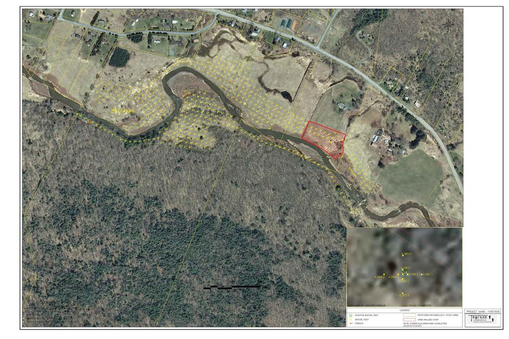
3 TABLE OF CONTENTS Introduction...1 Environment! Prehistoric Potential! Historic Potential! Field Methods! Field Results! Conclusions and Recommendations...6 Bibliography...7 Appendix 1:! Appendix 2:! Appendix 3:" Appendix 4:" Figures and Photos Shovel Tests Profiles and pictures of deep shovel tests Correspondence LIST OF FIGURES Figure 1! Ashland, New York USGS Figure 2! Location of the shovel tests on the project area Figure 3! 1779 Sauthier map Figure 4! 1856 Geil map Figure 5! 1867 Beers atlas Figure 6! 1903 USGS. Figure 7! County Soil Survey LIST OF PHOTOGRAPHS Photo 1!! Looking north from ST 185 Photo 2!! Looking into turnip patch Photo 3!! Looking south from turnip patch Photo 4!! Looking SE from near ST 7 3
4 INTRODUCTION Between December 9, 2016 and January 16, 2017, TRACKER Archaeology, Inc. conducted a Phase IA documentary study and a Phase IB survey for the proposed Batavia Stream Restoration Project at Kastanis in Ashland, Township of Ashland, Greene County, New York. In April of 2017, Tracker returned to the field to conduct 4 deep shovel tests as per NYSHPO request (Perazio lettter: 3/13/17; p.c.:3/2017). The purpose of the Phase IA documentary study was to determine the prehistoric and historic potential of the project area for the recovery of archaeological remains. The Phase IA was implemented by a review of the original and current environmental data, archaeological site files, other archival literature, maps, and documents. The prehistoric and historic site file and map search was conducted utilizing the resources of the New York Historic Preservation Office in Waterford, New York. Various historic web sites may have been queried via the internet to review any pertinent site information. The purpose of the Phase IB survey was to recover physical evidence for the presence or absence of archaeological remains on the property before their potential destruction. This was accomplished through subsurface testing and ground surface reconnaissance. The project area (APE) is approximately 27 acres along the north and south sides of Batavia Kill, south of C.R. 23 on private (Kastanis & others) or public lands (NYCDEP). The study was completed by TRACKER Archaeology, Inc. of Monroe, New York. Prehistoric and historic research was conducted by PI, Alfred G. Cammisa, M.A. Field work was conducted by field director Alexander DʻAmico, M.A. and field technician Alfred T. Cammisa. A gas powered machine mounted auger along with operator from the client (Green County S&WCD) assisted with the deep field testing. Artifact analysis by Joseph Diamond, PhD. Report preparation by Alfred G. Cammisa with Alexander Padilla (CAD). The work was performed for Greene County Soil and Water District, Cairo, New York. ENVIRONMENT Geology The project area is located in the eastern portion of New York State in the central section of Greene County. This portion of New York lies within the Appalachian Plateau Physiographic Province. The Appalachian Plateau is the last important physiographic province of the Appalachian Highlands. It extends from the Catskill region, south to Alabama. Much of the rock in the Catskill mountains was deposited by rivers near sea level rather than by sea water. During the Pleistocene Period, glaciers advanced and retreated several times across the state, with the last retreat about 10,000 years ago. While the main continental ice sheet retreated, smaller mountain glaciers lingered in highland areas such as the Catskill Mountains. The result was concentrated erosion within stream valleys and sharpened landscapes. Such natural features as striations, roches moutonnees, cirques, and U-shaped valleys are common in this region (Schuberth 1968: cover map, 18; Isachsen et al 2000: 104, 163, 167, 191). Soil and Topography Soils on the property consist of: 1
5 NAME SOIL HORIZON DEPTH IN(CM) COLOR TEXTURE & INCLUSION SLOPE % DRAINAGE LANDFORM Barber Ap=0-9 (0-23) B=9-15 (-38) Tunkhannock Ap=0-7(0-18) B=7-13 (-33) Ontera Ap 0-9 (0-23) B 9-14 (-36) 5YR3/4 5YR4/6 7.5YR3/2 5YR5/4 5YR3/2 5YR4/4 Lo 0-3 well alluvial deposits GrLo 5-16 well top & sides of kames & terraces SiLo 3-15 poor glacial till (Broad 1993: map #16, pgs. 28, 105, 120, 141, 185, 190). KEY: Shade: Lt=Light, Dk=Dark, V=Very Color: Br=Brown, Blk=Black, Gry=Gray, Gbr=Gray Brown, StBr=Strong Brown, Rbr=Red Brown, Ybr= Yellow Brown Soils: Si=Silt, Lo=Loam, Sa=Sand, Cl=Clay Other: Sh=shale, M=Mottle, Gr=Gravelly, Cb=cobbles, Ch=channery, Fi=Fine,/=or Elevations range from approximately 1360 to 1400 feet above mean sea level. Hydrology The Batavia Kill flows through the project corridor and west into the Schoharie River. The Schoharie River flows north to the Mohawk River. Vegetation The predominant forest community in this area was probably the Northern Hardwood Forest. This forest has many species in common with the Boreal Forest to the north and the Oak-Hickory Forest to the south. It is therefore referred to as the transition forest (Kricher 1988:38, 49-50). At the time of the Phase IB field survey, the study area consisted largely of an open grassy field. There was a small recently plowed turnip patch north of the Batavia Kill a wooded section south of the kill. PREHISTORIC POTENTIAL A prehistoric site file search was conducted at the New York State Historic Preservation Office. The search included a 1 mile radius around the study area. The following sites were recorded: -No prehistoric sites were reported. Assessing the known environmental and prehistoric data, we can summarize the following: -The Batavia Kill flows through the project corridor and west into the Schoharie River. The Schoharie River flows north to the Mohawk River. 2
6 -The study area is situated on mostly well drained soils with some poorly drained soils on level to some steeply sloping terrain. -No prehistoric sites are situated in the vicinity of the project area. In our opinion, the project area has a higher than average potential for the recovery of prehistoric remains. The type of site encountered could possibly be a procurement/processing camp or station from the Woodland or Archaic Periods. HISTORIC POTENTIAL Contact Period (Seventeenth Century) At the time of European contact and settlement, the study area was probably occupied by either the Mechkentowoons, a branch or village of the large Mahican tribe or the Mohawk tribe, both of which interfaced along this area. A mention is made in the Coeyman Purchase that the territory of western drainage to the Schoharie Creek was inhabited by the Mohawks. However, mention is also made that the Mechkentowoons lived north of the Katskill Indians. The map of Indians of New York shows the study area inhabited by the Mahicans. Borders of habitation were also probably greatly affected by the wars fought between the two large tribes (Ruttenber 1992: 57-61, 85, 95). Population of the neighboring Katskill people, who occupied the eastern drainage, was reported at approximately 250 between 1600 and 1650 (Becker 1993:18). An Indian foot trail existed along, or near, the New York State Thruway. It started near the junction of the Catskill and Kaaterskill Creeks and extended to Albany (Pelletreau 1884:153; Beecher 2001:p.c., Ruttenber 1992). Eighteenth Century The 1779 Sauthier map shows the study area along the Batavia Kill just east of the Schoharie River juncture (Figure 3). The first settlers in town was George Stimson and family in The Stimson brothers and Elisha Strong were the first settlers in Ashland Village. Ashland village was originally called Scienceville due to the higher education of some of the families there (Vedder 1927:15, 16). By 1789, there was a store and an inn in the village. The first doctor arrived by The early village was described as having endless grasslands for grazing and cornfields (Vedder 1927: 16, 17). Other early crops consisted of wheat, oats, and barley (Town of Ashland 2008). Wolves were a menace in town, killing the settlers cattle and sheep before being eradicated by wolf hunts/drives. Most of the early homes were of logs until saw mills were built along the streams (Vedder ). Nineteenth Century Between 1850 and 1855, the tannery business collapsed due to the over harvesting of hemlock. Cotton and wool mills also suffered at this time due to their inland location and resulting high transport costs. In 1860, the hat-making business in town also failed (Vedder 1927:15) The 1856 Geil atlas shows the project area along Batavia Kill. The stream is shown approximately in a slightly different configuration. No buildings are on or immediately adjacent to the project corridor. There are houses along Route 23 nearby (Figure 4).!!! 3
7 The 1867 Beers atlas depicts no buildings on or immediately adjacent to the project corridor Batavia Kill. However, the stream appears to be set back further from the road on this map (Figure 5). Twentieth Century The 1903 USGS shows a building adjacent on or adjacent to the project corridor (Figure 6). The tourist industry in this region continued to expand during this century (Vedder 1927:95). An historic site file search was conducted at the New York State Historic Preservation Office. The search included a 1 mile radius around the study area. The following sites were recorded: NYSM Sites NYSHPO Sites Distance to APE ft(m) Site Type (745) Turning shop, no remains (721) Sawmill, standing ruins associated with Gristmill (786) Gristmill, extensive foundation remains, gear parts recovered Assessing the known environmental and historic data, we can summarize the following: -The Batavia Kill flows through the project corridor and west into the Schoharie River. The Schoharie River flows north to the Mohawk River. -The study area is situated on mostly well drained soils with some poorly drained soils on level to some steeply sloping terrain. -Only the 1903 map shows a historic map documented structure on or adjacent to the project corridor. -Historic industrial sites are reported near the project area. In our opinion, the study area has a higher than average potential for the recovery of nineteenth century industrial sites. FIELD METHODS Walkover Exposed ground surfaces were subjected to a close quarters walk- over at approximately 3 to 5 meter transects. Covered ground terrain was reconnoitered at 15 intervals, or less, for any above ground features, such as berms, depressions, rock configurations, etc. that could be evidence for a prehistoric or historic site. Photographs were taken of the project area. 4
8 Shovel Testing Shovel tests were excavated at 15 meter intervals across the project area. A gas powered track mounted auger was also utilized and operated by the client Green County S&WCD along most of the north side of the project area. Shovel/auger tests were paced apart. Each shovel/auger test measured about 30 to 45 cm. in diameter and was dug into the underlying subsoil (B horizon/or bottom E) 10 to 20 cm. when possible. All soils were screened through 1/4 inch wire mesh and observed for artifacts. Shovel/auger tests were flagged and numbered in the field. All shovel/auger tests were mapped on the project area map at this time. Soil stratigraphy was recorded according to texture and color. Soil color was matched against the Munsell color chart for soils. Notes were transcribed in a notebook. A power auger was used to assist in digging STʼs in deeper alluvium, up to about 1 meter, and was based on testing an area which was not a known archaeological site, therefore not particularly destructive. This method has been used in the past by the author and is still mentioned in the latest Field Methods in Archeology, 7th edition. If archaeological sites were identified by power auger then the crew was instructed to switch to hand excavation of STʼs. FIELD RESULTS Field testing of the project area included the excavation of 440 shovel/auger tests (STʼs) across the project area at 50 foot intervals. Power auguring was conducted from STʼs 19 to 274. Prehistoric artifacts were encountered at ST 438. Radial shovel testing was conducted at 1 and 3 meters in the four cardinal directions from positive ST 438. A small prehistoric site was encountered. No historic sites were encountered. In addition, 4 deep, hand excavated, shovel tests (trenches) were conducted down as deep as was safe (5ʼ-6.5ʼ), using a stepped descent in each ST, for safety. Each of the 4 deep tests were excavated down into sand. According to the County Soil Survey, sand was considered the C horizon in Barbour soils (alluvial soils). No artifacts were retrieved from this sand (C horizon). Soils consisted of a sometimes deep alluvium for most of the project area, but especially so on the north side of the kill. One small section of the project area was a turnip patch with bare earth exposed. This section, also along the north side of the kill, was subjected to a walkover-reconnaissance because of the high soil visibility. Stratigraphy Stratigraphy across the property generally included the following: -A/O horizon: 2 to 11 cm. thick of root mat, leaf litter, and/or humus. -A horizon/e1: 23 to 83 cm. thick of 5YR3/3 dark red brown loam. Most of the deep alluvium was on the north side of the kill. -B horizon/e2: 10 to 20 cm. dug into of 2.5YR4/4 red brown clay (heavier) loam. This layer occasionally was observed to overlie a gravelly and rocky layer which was thought to be an old stream bed. -C Horizon: for Deep Tests only, 6 to 88 cm. dug into of 2.5YR3/3 dark red brown to 2.5 3/1 dark red grey sand. Two artifacts were found in Deep Test 2 (north side of Kill), salt glaze stoneware at 70 cm. and a kaolin pipestem at 120 cm. Most of the STʼs on the north side had gone down past 70 cm. In fact, deep test 2 was excavated over the previous ST 87 which had a depth of 91 cm. The pipe stem at 120 cm. was a bit lower than the STʼs previously excavated, however this small artifact could have been a drift-down within this watery area over time. 5
9 Artifacts at the prehistoric site were recovered from within the first 30 cm. of the STʼs: ST Artifact Count Type tertiary flake, grey chert (.3g), 1 shatter, Mt. Merino chert (2.1g) 438 North 1 meter 1 tertiary flake, green M. Merino (.4g) 438 East 1 meter 2 tertiary flakes, Mt. Merino (2.9g) CONCLUSIONS AND RECOMMENDATIONS Based upon topographic characteristics and proximity to prehistoric sites, the property was assessed as having a higher than average potential for encountering prehistoric sites on any intact soils. Based upon topographic characteristics and proximity to historic sites and MDSʼs, the property was assessed as having an above average potential for encountering historic sites on any intact soils. During the course of the archaeological field survey 448 auger/stʼs were excavated. In addition, 4 deep tests were conducted into sand (C horizon). No historic sites were encountered. However, a small prehistoric site was encountered. The purpose of the Phase I archaeological survey is to establish the presence or absence of archaeological sites. It appears that this prehistoric site will be avoided by the project impacts. However, if the site is to be impacted by proposed construction or other activities, Phase II intensive testing of any archaeological site is them specified by the regulations of the New York State Historic Preservation Office and the National Advisory Council on Historic preservation. Phase II investigation methods should interpret the archaeological site and determine if it is eligible for the nomination to State or National Registers of Historic Places. We recommend Phase II intensive testing on the prehistoric site prior to any development related ground breaking or construction which threatens site information. Phase II investigations would supply information needed to make this determination and would include: 1) Site integrity, including the depth and extent of undisturbed soil horizons and the presence or absence of cultural features, and the degree of natural and/or human disturbances to those features. 2) Cultural components/affiliations and time range present. 3) Vertical and horizontal distribution of archaeological remains (spatial boundaries and stratigraphic levels). 4) Site interpretation, including any uniqueness/significance, in a local or regional context, must be demonstrated. No further work is recommended recommended for the remainder of the project area. 6
10 BIBLIOGRAPHY Town of Ashland 2008! Ashland Historian. Becker, Marshall Joseph 1993! The Lenape and Other Delawaren: Peoples at the Time of European Contact: Population Estimates Derived from Archaeological Evidence and Historical Sources, in Journal of the New York State Archaeological Bulletin. Spring, #105. Broad, William A. 1993! Soil Survey of Greene County, New York. United States Department of Agriculture, Soil Conservation Services in Cooperation with Cornell University Agricultural Experimental Station. Isachsen, P.W., E. Landing, J.R. Lauder, LV. Richard, W.B. Rogers 2000! Geology of New York: A Simplified Account. New York State Museum. Kricher, John C The Peterson Field Guide Series: Eastern Forests of North America. Houghton Mifflin Company,! Boston. Perazio, Philip, Historic Preservation Analyst-Archaeology Unit 2017! Letter from March 13, ! personal communication. Ruttenber, E.M. 1992! Indian Tribes of Hudsonʼs River - to Hope Farm Press, Saugerties, New York. Schuberth, Christopher J. 1968! The Geology of New York City and Environs. New York: Natural History Press. Vedder, Van Vechten J. 1927! Official History of Greene County, New York. Greene County Board of Supervisors. Maps Beers, F.W. 1867! Atlas of Greene County. F.W. Beers, A.D. Ellis, and Company, Geil, Samuel 1856! Atlas of Greene County, NY. E.A. Balch, PA. Hearne Brothers not dated Indians of New York. Earth Science Projection Map. Hearne Brothers, Michigan. Sauthier, Claude Joseph 1779! A Chronological Map of the Province of New York in North America, Divided into Counties, Manors, Patents, Townships, and Grants of Land. William Faden, London. United States Geological Survey 1945! Ashland, New York quadrangles, 7.5 minute series(rev.1980). 1903!Gilboa, New York quadrangle, 15 minute series. 7
11 APPENDIX 1 8

12 Figure 1 Ashland, NY USGS N project area
13

14 Figure 3 N N 1779 Sauthier map project vicinity

15 Figure Geil map N project area

16 Figure 5 N 1867 Beers atlas project area

17 Figure USGS N project area

18 Figure 7 N County Soil Survey project area

19 Photo 1 Looking north from ST 185

20 Photo 2 Looking into turnip patch

21 Photo 3 Looking south from turnip patch

22 Photo 4 Looking SE from near ST 7
23 APPENDIX 2 9
24 SHOVEL TESTS STP! LV! DEPTH(CM)! TEXTURE!! COLOR! HOR! COMMENT 1! 1! 0-2!! rootmat,leaves,humus!!! A/O! NCM! 2! 2-70!! Lo!!! 5YR3/3!! A! NCM! 3! !! ClLo!!! 2.5YR4/4! B! NCM 2! 1! 0-4!! rootmat,leaves,humus!!! A/O! NCM! 2! 4-73!! Lo!!! 5YR3/3!! A! brick! 3! 73-84!! ClLo!!! 2.5YR4/4! B! NCM 3! 1! 0-4!! rootmat,leaves,humus!!! A/O! NCM! 2! 4-74!! Lo!!! 5YR3/3!! A! NCM! 3! 74-84!! ClLo!!! 2.5YR4/4! B! NCM 4! 1! 0-3!! rootmat,leaves,humus!!! A/O! NCM! 2! 3-76!! Lo!!! 5YR3/3!! A! NCM! 3! 76-88!! ClLo!!! 2.5YR4/4! B! NCM 5! 1! 0-2!! rootmat,leaves,humus!!! A/O! NCM! 2! 2-85!! Lo!!! 5YR3/3!! A! NCM! 3! 85-96!! ClLo!!! 2.5YR4/4! B! NCM!! 6! 1! 0-5!! rootmat,leaves,humus!!! A/O! NCM! 2! 5-74!! Lo!!! 5YR3/3!! A! NCM! 3! 74-84!! ClLo!!! 2.5YR4/4! B! NCM 7! 1! 0-5!! rootmat,leaves,humus!!! A/O! NCM! 2! 5-69!! Lo!!! 5YR3/3!! A! NCM! 3! !! ClLo!!! 2.5YR4/4! B! NCM 8! 1! 0-5!! rootmat,leaves,humus!!! A/O! NCM! 2! 5-72!! Lo!!! 5YR3/3!! A! NCM! 3! 72-88!! ClLo!!! 2.5YR4/4! B! NCM 9! 1! 0-4!! rootmat,leaves,humus!!! A/O! NCM! 2! 4-68!! Lo!!! 5YR3/3!! A! NCM! 3! 68-90!! ClLo!!! 2.5YR4/4! B! NCM 10! 1! 0-5!! rootmat,leaves,humus!!! A/O! NCM! 2! 5-61!! Lo!!! 5YR3/3!! A! NCM! 3! 61-91!! ClLo!!! 2.5YR4/4! B! NCM 11! 1! 0-4!! rootmat,leaves,humus!!! A/O! NCM! 2! 4-71!! Lo!!! 5YR3/3!! A! NCM! 3! 71-99!! ClLo!!! 2.5YR4/4! B! NCM 12! 1! 0-3!! rootmat,leaves,humus!!! A/O! NCM! 2! 3-61!! Lo!!! 5YR3/3!! A! NCM! 3! 61-92!! ClLo!!! 2.5YR4/4! B! NCM 13! 1! 0-5!! rootmat,leaves,humus!!! A/O! NCM! 2! 5-78!! Lo!!! 5YR3/3!! A! NCM! 3! 78-94!! ClLo!!! 2.5YR4/4! B! NCM 10
25 14! 1! 0-5!! rootmat,leaves,humus!!! A/O! NCM! 2! 5-65!! Lo!!! 5YR3/3!! A! NCM! 3! 65-97!! ClLo!!! 2.5YR4/4! B! NCM 15! 1! 0-4!! rootmat,leaves,humus!!! A/O! NCM! 2! 4-72!! Lo!!! 5YR3/3!! A! NCM! 3! 72-84!! ClLo!!! 2.5YR4/4! B! NCM 16! 1! 0-4!! rootmat,leaves,humus!!! A/O! NCM! 2! 4-68!! Lo!!! 5YR3/3!! A! NCM! 3! 68-92!! ClLo!!! 2.5YR4/4! B! NCM 17! 1! 0-5!! rootmat,leaves,humus!!! A/O! NCM! 2! 5-73!! Lo!!! 5YR3/3!! A! NCM! 3! !! ClLo!!! 2.5YR4/4! B! NCM 18! 1! 0-3!! rootmat,leaves,humus!!! A/O! NCM! 2! 3-77!! Lo!!! 5YR3/3!! A! NCM! 3! 77-92!! ClLo!!! 2.5YR4/4! B! NCM power auger begins 19! 1! 0-3!! rootmat,leaves,humus!!! A/O! NCM! 2! 3-78!! Lo!!! 5YR3/3!! A! NCM! 3! 78-85!! ClLo!!! 2.5YR4/4! B! NCM 20! 1! 0-5!! rootmat,leaves,humus!!! A/O! NCM! 2! 5-80!! Lo!!! 5YR3/3!! A! NCM! 3! 80-96!! ClLo!!! 2.5YR4/4! B! NCM 21! 1! 0-3!! rootmat,leaves,humus!!! A/O! NCM! 2! 3-69!! Lo!!! 5YR3/3!! A! NCM! 3! 69-90!! ClLo!!! 2.5YR4/4! B! NCM 22! 1! 0-4!! rootmat,leaves,humus!!! A/O! NCM! 2! 4-78!! Lo!!! 5YR3/3!! A! undec ww, mortar! 3! 78-97!! ClLo!!! 2.5YR4/4! B! NCM 23! 1! 0-4!! rootmat,leaves,humus!!! A/O! NCM! 2! 4-78!! Lo!!! 5YR3/3!! A! NCM! 3! 78-98!! SiSaLo!!! 2.5YR4/4! B! NCM 24! 1! 0-5!! rootmat,leaves,humus!!! A/O! NCM! 2! 5-62!! Lo!!! 5YR3/3!! A! NCM! 3! 62-84!! SiSaLo!!! 2.5YR4/4! B! NCM 25! 1! 0-5!! rootmat,leaves,humus!!! A/O! NCM! 2! 5-78!! Lo!!! 5YR3/3!! A! NCM! 3! 78-88!! ClLo!!! 2.5YR4/4! B! NCM 26! 1! 0-5!! rootmat,leaves,humus!!! A/O! NCM! 2! 5-61!! Lo!!! 5YR3/3!! A! NCM! 3! 61-92!! ClLo!!! 2.5YR4/4! B! NCM 11
26 27! 1! 0-4!! rootmat,leaves,humus!!! A/O! NCM! 2! 4-72!! Lo!!! 5YR3/3!! A! NCM! 3! 72-93!! ClLo!!! 2.5YR4/4! B! NCM 28! 1! 0-3!! rootmat,leaves,humus!!! A/O! NCM! 2! 3-78!! Lo!!! 5YR3/3!! A! NCM! 3! 78-95!! ClLo!!! 2.5YR4/4! B! NCM 29! 1! 0-3!! rootmat,leaves,humus!!! A/O! NCM! 2! 3-78!! Lo!!! 5YR3/3!! A! NCM! 3! 78-95!! ClLo!!! 2.5YR4/4! B! NCM 30! 1! 0-3!! rootmat,leaves,humus!!! A/O! NCM! 2! 3-78!! Lo!!! 5YR3/3!! A! NCM! 3! 78-95!! ClLo!!! 2.5YR4/4! B! NCM 31! 1! 0-5!! rootmat,leaves,humus!!! A/O! NCM! 2! 5-64!! Lo!!! 5YR3/3!! A! NCM! 3! 64-85!! ClLo!!! 2.5YR4/4! B! NCM 32! 1! 0-5!! rootmat,leaves,humus!!! A/O! NCM! 2! 5-64!! Lo!!! 5YR3/3!! A! NCM! 3! 64-85!! ClLo!!! 2.5YR4/4! B! NCM 33! 1! 0-3!! rootmat,leaves,humus!!! A/O! NCM! 2! 3-70!! Lo!!! 5YR3/3!! A! NCM! 3! 70-96!! ClLo!!! 2.5YR4/4! B! NCM 34! 1! 0-3!! rootmat,leaves,humus!!! A/O! NCM! 2! 3-60!! Lo!!! 5YR3/3!! A! NCM! 3! 60-93!! ClLo!!! 2.5YR4/4! B! NCM 35! 1! 0-4!! rootmat,leaves,humus!!! A/O! NCM! 2! 4-67!! Lo!!! 5YR3/3!! A! NCM! 3! !! ClLo!!! 2.5YR4/4! B! NCM 36! 1! 0-4!! rootmat,leaves,humus!!! A/O! NCM! 2! 4-64!! Lo!!! 5YR3/3!! A! NCM! 3! 64-86!! ClLo!!! 2.5YR4/4! B! NCM 37! 1! 0-4!! rootmat,leaves,humus!!! A/O! NCM! 2! 4-76!! Lo!!! 5YR3/3!! A! NCM! 3! 76-89!! ClLo!!! 2.5YR4/4! B! NCM 38! 1! 0-2!! rootmat,leaves,humus!!! A/O! NCM! 2! 2-78!! Lo!!! 5YR3/3!! A! NCM! 3! 78-84!! ClLo!!! 2.5YR4/4! B! NCM 39! 1! 0-5!! rootmat,leaves,humus!!! A/O! NCM! 2! 5-79!! Lo!!! 5YR3/3!! A! NCM! 3! 79-86!! ClLo!!! 2.5YR4/4! B! NCM 12
27 40! 1! 0-2!! rootmat,leaves,humus!!! A/O! NCM! 2! 2-66!! Lo!!! 5YR3/3!! A! nail! 3! 66-91!! ClLo!!! 2.5YR4/4! B! NCM 41! 1! 0-5!! rootmat,leaves,humus!!! A/O! NCM! 2! 5-77!! Lo!!! 5YR3/3!! A! NCM! 3! 77-93!! ClLo!!! 2.5YR4/4! B! NCM 42! 1! 0-5!! rootmat,leaves,humus!!! A/O! NCM! 2! 5-60!! Lo!!! 5YR3/3!! A! NCM! 3! 60-90!! ClLo!!! 2.5YR4/4! B! NCM 43! 1! 0-2!! rootmat,leaves,humus!!! A/O! NCM! 2! 2-63!! Lo!!! 5YR3/3!! A! NCM! 3! !! ClLo!!! 2.5YR4/4! B! NCM 44! 1! 0-4!! rootmat,leaves,humus!!! A/O! NCM! 2! 4-67!! Lo!!! 5YR3/3!! A! NCM! 3! 67-98!! ClLo!!! 2.5YR4/4! B! NCM 45! 1! 0-2!! rootmat,leaves,humus!!! A/O! NCM! 2! 2-64!! Lo!!! 5YR3/3!! A! NCM! 3! 64-84!! ClLo!!! 2.5YR4/4! B! NCM 46! 1! 0-4!! rootmat,leaves,humus!!! A/O! NCM! 2! 4-64!! Lo!!! 5YR3/3!! A! NCM! 3! 64-98!! ClLo!!! 2.5YR4/4! B! NCM 47! 1! 0-3!! rootmat,leaves,humus!!! A/O! NCM! 2! 3-76!! Lo!!! 5YR3/3!! A! NCM! 3! 76-88!! ClLo!!! 2.5YR4/4! B! NCM 48! 1! 0-5!! rootmat,leaves,humus!!! A/O! NCM! 2! 5-63!! Lo!!! 5YR3/3!! A! NCM! 3! 63-86!! ClLo!!! 2.5YR4/4! B! NCM 49! 1! 0-5!! rootmat,leaves,humus!!! A/O! NCM! 2! 5-70!! Lo!!! 5YR3/3!! A! NCM! 3! 70-91!! ClLo!!! 2.5YR4/4! B! NCM 50! 1! 0-5!! rootmat,leaves,humus!!! A/O! NCM! 2! 5-60!! Lo!!! 5YR3/3!! A! NCM! 3! 60-98!! ClLo!!! 2.5YR4/4! B! NCM 51! 1! 0-4!! rootmat,leaves,humus,!!! A/O! NCM! 2! 4-71!! Lo!!! 5YR3/3!! A! NCM! 3! 71-87!! ClLo!!! 2.5YR4/4! B! NCM 52! 1! 0-5!! rootmat,leaves,humus!!! A/O! NCM! 2! 5-64!! Lo!!! 5YR3/3!! A! NCM! 3! 64-93!! ClLo!!! 2.5YR4/4! B! NCM 13
28 53! 1! 0-5!! rootmat,leaves,humus!!! A/O! NCM! 2! 5-62!! Lo!!! 5YR3/3!! A! NCM! 3! !! ClLo!!! 2.5YR4/4! B! NCM 54! 1! 0-2!! rootmat,leaves,humus!!! A/O! NCM! 2! 2-60!! Lo!!! 5YR3/3!! A! NCM! 3! !! ClLo!!! 2.5YR4/4! B! NCM 55! 1! 0-4!! rootmat,leaves,humus!!! A/O! NCM! 2! 4-61!! Lo!!! 5YR3/3!! A! NCM! 3! !! ClLo!!! 2.5YR4/4! B! NCM Note: still overlying gravelly creek bed 56! 1! 0-5!! rootmat,leaves,humus!!! A/O! NCM! 2! 5-70!! Lo!!! 5YR3/3!! A! NCM! 3! !! ClLo!!! 2.5YR4/4! B! NCM 57! 1! 0-3!! rootmat,leaves,humus!!! A/O! NCM! 2! 3-79!! Lo!!! 5YR3/3!! A! NCM! 3! 79-86!! ClLo!!! 2.5YR4/4! B! NCM 58! 1! 0-5!! rootmat,leaves,humus!!! A/O! NCM! 2! 5-63!! SiSaLo,water!! 5YR3/3!! A! NCM! 3! 63-89!! ClLo!!! 2.5YR4/4! B! NCM 59! 1! 0-5!! rootmat,leaves,humus!!! A/O! NCM! 2! 5-62!! Lo!!! 5YR3/3!! A! NCM! 3! 62-97!! ClLo!!! 2.5YR4/4! B! NCM 60! 1! 0-3!! rootmat,leaves,humus!!! A/O! NCM! 2! 3-74!! Lo!!! 5YR3/3!! A! NCM! 3! 74-93!! ClLo!!! 2.5YR4/4! B! NCM 61! 1! 0-3!! rootmat,leaves,humus!!! A/O! NCM! 2! 3-65!! Lo!!! 5YR3/3!! A! NCM! 3! 65-95!! ClLo!!! 2.5YR4/4! B! NCM 62! 1! 0-5!! rootmat,leaves,humus!!! A/O! NCM! 2! 5-79!! Lo!!! 5YR3/3!! A! NCM! 3! 79-84!! ClLo!!! 2.5YR4/4! B! NCM 63! 1! 0-2!! rootmat,leaves,humus!!! A/O! NCM! 2! 2-65!! Lo!!! 5YR3/3!! A! NCM! 3! 65-89!! ClLo!!! 2.5YR4/4! B! NCM 64! 1! 0-4!! rootmat,leaves,humus!!! A/O! NCM! 2! 4-70!! Lo!!! 5YR3/3!! A! NCM! 3! 70-84!! ClLo!!! 2.5YR4/4! B! NCM 65! 1! 0-5!! rootmat,leaves,humus!!! A/O! NCM! 2! 5-78!! Lo!!! 5YR3/3!! A! NCM! 3! 78-94!! ClLo!!! 2.5YR4/4! B! NCM 14
29 66! 1! 0-5!! rootmat,leaves,humus!!! A/O! NCM! 2! 5-71!! Lo!!! 5YR3/3!! A! NCM! 3! 71-98!! ClLo!!! 2.5YR4/4! B! NCM 67! 1! 0-2!! rootmat,leaves,humus!!! A/O! NCM! 2! 2-79!! Lo!!! 5YR3/3!! A! NCM! 3! 79-95!! ClLo!!! 2.5YR4/4! B! NCM 68! 1! 0-5!! rootmat,leaves,humus!!! A/O! NCM! 2! 5-62!! Lo!!! 5YR3/3!! A! NCM! 3! 62-96!! ClLo!!! 2.5YR4/4! B! NCM 69! 1! 0-4!! rootmat,leaves,humus!!! A/O! NCM! 2! 4-60!! Lo!!! 5YR3/3!! A! NCM! 3! 60-98!! ClLo!!! 2.5YR4/4! B! NCM 70! 1! 0-3!! rootmat,leaves,humus!!! A/O! NCM! 2! 3-71!! Lo!!! 5YR3/3!! A! NCM! 3! 71-94!! ClLo!!! 2.5YR4/4! B! NCM 71! 1! 0-3!! rootmat,leaves,humus!!! A/O! NCM! 2! 3-76!! Lo!!! 5YR3/3!! A! ww, wingl! 3! 76-87!! ClLo!!! 2.5YR4/4! B! NCM 72! 1! 0-5!! rootmat,leaves,humus!!! A/O! NCM! 2! 5-80!! Lo!!! 5YR3/3!! A! NCM! 3! 80-97!! ClLo!!! 2.5YR4/4! B! NCM 73! 1! 0-3!! rootmat,leaves,humus!!! A/O! NCM! 2! 3-76!! Lo!!! 5YR3/3!! A! NCM! 3! 76-88!! ClLo!!! 2.5YR4/4! B! NCM 74! 1! 0-3!! rootmat,leaves,humus!!! A/O! NCM! 2! 3-80!! Lo!!! 5YR3/3!! A! NCM! 3! 80-85!! ClLo!!! 2.5YR4/4! B! NCM 75! 1! 0-4!! rootmat,leaves,humus!!! A/O! NCM! 2! 4-81!! Lo!!! 5YR3/3!! A! NCM! 3! 81-86!! ClLo!!! 2.5YR4/4! B! NCM 76! 1! 0-5!! rootmat,leaves,humus!!! A/O! NCM! 2! 5-65!! Lo!!! 5YR3/3!! A! NCM! 3! 65-96!! ClLo!!! 2.5YR4/4! B! NCM 77! 1! 0-4!! rootmat,leaves,humus!!! A/O! NCM! 2! 4-64!! Lo!!! 5YR3/3!! A! NCM! 3! 64-96!! ClLo!!! 2.5YR4/4! B! NCM!! 78! 1! 0-4!! rootmat,leaves,humus!!! A/O! NCM! 2! 4-61!! Lo!!! 5YR3/3!! A! NCM! 3! 61-94!! ClLo!!! 2.5YR4/4! B! NCM 15
30 79! 1! 0-3!! rootmat,leaves,humus!!! A/O! NCM! 2! 3-71!! Lo!!! 5YR3/3!! A! NCM! 3! 71-98!! ClLo!!! 2.5YR4/4! B! NCM 80! 1! 0-3!! rootmat,leaves,humus!!! A/O! NCM! 2! 3-64!! Lo!!! 5YR3/3!! A! NCM! 3! !! ClLo!!! 2.5YR4/4! B! NCM 81! 1! 0-3!! rootmat,leaves,humus!!! A/O! NCM! 2! 3-61!! Lo!!! 5YR3/3!! A! NCM! 3! !! ClLo!!! 2.5YR4/4! B! NCM 82! 1! 0-3!! rootmat,leaves,humus!!! A/O! NCM! 2! 3-75!! Lo!!! 5YR3/3!! A! NCM! 3! 75-88!! ClLo!!! 2.5YR4/4! B! NCM 83! 1! 0-4!! rootmat,leaves,humus!!! A/O! NCM! 2! 4-62!! Lo!!! 5YR3/3!! A! NCM! 3! 62-94!! ClLo!!! 2.5YR4/4! B! NCM 84! 1! 0-3!! rootmat,leaves,humus!!! A/O! NCM! 2! 3-75!! Lo!!! 5YR3/3!! A! NCM! 3! 75-95!! ClLo!!! 2.5YR4/4! B! NCM 85! 1! 0-3!! rootmat,leaves,humus!!! A/O! NCM! 2! 3-66!! Lo!!! 5YR3/3!! A! NCM! 3! !! ClLo!!! 2.5YR4/4! B! NCM 86! 1! 0-3!! rootmat,leaves,humus!!! A/O! NCM! 2! 3-79!! Lo!!! 5YR3/3!! A! NCM! 3! !! ClLo!!! 2.5YR4/4! B! NCM 87! 1! 0-5!! rootmat,leaves,humus!!! A/O! NCM! 2! 5-71!! Lo!!! 5YR3/3!! A! NCM! 3! 71-91!! ClLo!!! 2.5YR4/4! B! NCM 88! 1! 0-5!! rootmat,leaves,humus!!! A/O! NCM! 2! 5-61!! Lo!!! 5YR3/3!! A! NCM! 3! 61-91!! Lo!!! 2.5YR4/4! B! NCM 89! 1! 0-3!! rootmat,leaves,humus!!! A/O! NCM! 2! 3-81!! Lo!!! 5YR3/3!! A! NCM! 3! 81-98!! ClLo!!! 2.5YR4/4! B! NCM 90! 1! 0-3!! rootmat,leaves,humus!!! A/O! NCM! 2! 3-64!! Lo!!! 5YR3/3!! A! NCM! 3! 64-98!! ClLo!!! 2.5YR4/4! B! NCM 91! 1! 0-3!! rootmat,leaves,humus!!! A/O! NCM! 2! 3-66!! Lo!!! 5YR3/3!! A! NCM! 3! 66-94!! ClLo!!! 2.5YR4/4! B! NCM 16
31 92! 1! 0-3!! rootmat,leaves,humus!!! A/O! NCM! 2! 3-73!! Lo!!! 5YR3/3!! A! NCM! 3! 73-93!! ClLo!!! 2.5YR4/4! B! NCM 93! 1! 0-4!! rootmat,leaves,humus!!! A/O! NCM! 2! 4-60!! Lo!!! 5YR3/3!! A! NCM! 3! !! ClLo!!! 2.5YR4/4! B! NCM 94! 1! 0-3!! rootmat,leaves,humus!!! A/O! NCM! 2! 3-70!! Lo!!! 5YR3/3!! A! NCM! 3! 70-84!! ClLo!!! 2.5YR4/4! B! NCM 95! 1! 0-5!! rootmat,leaves,humus!!! A/O! NCM! 2! 5-76!! Lo!!! 5YR3/3!! A! NCM! 3! 76-92!! ClLo!!! 2.5YR4/4! B! NCM 96! 1! 0-4!! rootmat,leaves,humus!!! A/O! NCM! 2! 4-70!! Lo!!! 5YR3/3!! A! NCM! 3! 70-96!! ClLo!!! 2.5YR4/4! B! NCM 97! 1! 0-3!! rootmat,leaves,humus!!! A/O! NCM! 2! 3-77!! Lo!!! 5YR3/3!! A! NCM! 3! !! ClLo!!! 2.5YR4/4! B! NCM 98! 1! 0-5!! rootmat,leaves,humus!!! A/O! NCM! 2! 5-67!! Lo!!! 5YR3/3!! A! NCM! 3! 67-85!! ClLo!!! 2.5YR4/4! B! NCM 99! 1! 0-5!! rootmat,leaves,humus!!! A/O! NCM! 2! 5-66!! Lo!!! 5YR3/3!! A! NCM! 3! 66-98!! ClLo!!! 2.5YR4/4! B! NCM 100! 1! 0-3!! rootmat,leaves,humus!!! A/O! NCM! 2! 3-69!! Lo!!! 5YR3/3!! A! NCM! 3! !! ClLo!!! 2.5YR4/4! B! NCM 101! 1! 0-3!! rootmat,leaves,humus!!! A/O! NCM! 2! 3-80!! Lo!!! 5YR3/3!! A! NCM! 3! 80-99!! ClLo!!! 2.5YR4/4! B! NCM 102! 1! 0-2!! rootmat,leaves,humus!!! A/O! NCM! 2! 2-73!! Lo!!! 5YR3/3!! A! NCM! 3! 73-89!! Lo!!! 2.5YR4/4! B! NCM 103! 1! 0-5!! rootmat,leaves,humus!!! A/O! NCM! 2! 5-76!! Lo!!! 5YR3/3!! A! NCM! 3! 76-94!! ClLo!!! 2.5YR4/4! B! NCM 104! 1! 0-3!! rootmat,leaves,humus!!! A/O! NCM! 2! 3-64!! Lo!!! 5YR3/3!! A! NCM! 3! !! ClLo!!! 2.5YR4/4! B! NCM 17
32 105! 1! 0-3!! rootmat,leaves,humus!!! A/O! NCM! 2! 3-63!! Lo!!! 5YR3/3!! A! NCM! 3! 63-95!! ClLo!!! 2.5YR4/4! B! NCM 106! 1! 0-2!! rootmat,leaves,humus!!! A/O! NCM! 2! 2-60!! Lo!!! 5YR3/3!! A! NCM! 3! 60-85!! ClLo!!! 2.5YR4/4! B! NCM 107! 1! 0-3!! rootmat,leaves,humus!!! A/O! NCM! 2! 3-68!! Lo!!! 5YR3/3!! A! NCM! 3! 68-87!! ClLo!!! 2.5YR4/4! B! NCM 108! 1! 0-3!! rootmat,leaves,humus!!! A/O! NCM! 2! 3-64!! Lo!!! 5YR3/3!! A! NCM! 3! 64-99!! ClLo!!! 2.5YR4/4! B! NCM 109! 1! 0-3!! rootmat,leaves,humus!!! A/O! NCM! 2! 3-72!! Lo!!! 5YR3/3!! A! NCM! 3! 72-89!! ClLo!!! 2.5YR4/4! B! NCM 110! 1! 0-5!! rootmat,leaves,humus!!! A/O! NCM! 2! 5-70!! Lo!!! 5YR3/3!! A! NCM! 3! 70-84!! ClLo!!! 2.5YR4/4! B! NCM 111! 1! 0-3!! rootmat,leaves,humus!!! A/O! NCM! 2! 3-75!! Lo!!! 5YR3/3!! A! NCM! 3! 75-93!! ClLo!!! 2.5YR4/4! B! NCM 112! 1! 0-5!! rootmat,leaves,humus!!! A/O! NCM! 2! 5-71!! Lo!!! 5YR3/3!! A! NCM! 3! 71-94!! ClLo!!! 2.5YR4/4! B! NCM 113! 1! 0-4!! rootmat,leaves,humus!!! A/O! NCM! 2! 4-61!! Lo!!! 5YR3/3!! A! NCM! 3! 61-98!! ClLo!!! 2.5YR4/4! B! NCM 114! 1! 0-3!! rootmat,leaves,humus!!! A/O! NCM! 2! 3-65!! Lo!!! 5YR3/3!! A! NCM! 3! 65-88!! ClLo!!! 2.5YR4/4! B! NCM 115! 1! 0-3!! rootmat,leaves,humus!!! A/O! NCM! 2! 3-79!! Lo!!! 5YR3/3!! A! NCM! 3! 79-94!! ClLo!!! 2.5YR4/4! B! NCM 116! 1! 0-3!! rootmat,leaves,humus!!! A/O! NCM! 2! 3-69!! Lo!!! 5YR3/3!! A! NCM! 3! 69-85!! ClLo!!! 2.5YR4/4! B! NCM 117! 1! 0-2!! rootmat,leaves,humus!!! A/O! NCM! 2! 2-61!! Lo!!! 5YR3/3!! A! NCM! 3! 61-86!! ClLo!!! 2.5YR4/4! B! NCM 18
33 118! 1! 0-3!! rootmat,leaves,humus!!! A/O! NCM! 2! 3-71!! Lo!!! 5YR3/3!! A! NCM! 3! 71-92!! ClLo!!! 2.5YR4/4! B! NCM 119! 1! 0-5!! rootmat,leaves,humus!!! A/O! NCM! 2! 5-67!! Lo!!! 5YR3/3!! A! NCM! 3! 67-91!! ClLo!!! 2.5YR4/4! B! NCM 120! 1! 0-3!! rootmat,leaves,humus!!! A/O! NCM! 2! 3-64!! Lo!!! 5YR3/3!! A! NCM! 3! 64-89!! ClLo!!! 2.5YR4/4! B! NCM 121! 1! 0-2!! rootmat,leaves,humus!!! A/O! NCM! 2! 2-63!! Lo!!! 5YR3/3!! A! NCM! 3! 63-96!! ClLo!!! 2.5YR4/4! B! NCM 122! 1! 0-2!! rootmat,leaves,humus!!! A/O! NCM! 2! 2-72!! Lo!!! 5YR3/3!! A! NCM! 3! 72-86!! ClLo!!! 2.5YR4/4! B! NCM 123! 1! 0-5!! rootmat,leaves,humus!!! A/O! NCM! 2! 5-62!! Lo!!! 5YR3/3!! A! NCM! 3! 62-85!! ClLo!!! 2.5YR4/4! B! NCM 124! 1! 0-2!! rootmat,leaves,humus!!! A/O! NCM! 2! 2-77!! Lo!!! 5YR3/3!! A! NCM! 3! 77-99!! ClLo!!! 2.5YR4/4! B! NCM 125! 1! 0-5!! rootmat,leaves,humus!!! A/O! NCM! 2! 5-80!! Lo!!! 5YR3/3!! A! NCM! 3! 80-94!! ClLo!!! 2.5YR4/4! B! NCM!! 126! 1! 0-5!! rootmat,leaves,humus!!! A/O! NCM! 2! 5-80!! Lo!!! 5YR3/3!! A! NCM! 3! 80-94!! ClLo!!! 2.5YR4/4! B! NCM!! 127! 1! 0-3!! rootmat,leaves,humus!!! A/O! NCM! 2! 3-61!! Lo!!! 5YR3/3!! A! NCM! 3! 61-97!! ClLo!!! 2.5YR4/4! B! NCM 128! 1! 0-5!! rootmat,leaves,humus!!! A/O! NCM! 2! 5-74!! Lo!!! 5YR3/3!! A! NCM! 3! 74-92!! ClLo!!! 2.5YR4/4! B! NCM!! 129! 1! 0-5!! rootmat,leaves,humus!!! A/O! NCM! 2! 5-60!! Lo!!! 5YR3/3!! A! NCM! 3! 60-88!! ClLo!!! 2.5YR4/4! B! NCM!! 130! 1! 0-2!! rootmat,leaves,humus!!! A/O! NCM! 2! 2-76!! Lo!!! 5YR3/3!! A! NCM! 3! 76-96!! ClLo!!! 2.5YR4/4! B! NCM 131! 1! 0-3!! rootmat,leaves,humus!!! A/O! NCM! 2! 3-68!! Lo!!! 5YR3/3!! A! NCM! 3! 68-95!! ClLo!!! 2.5YR4/4! B! NCM 19
34 132! 1! 0-3!! rootmat,leaves,humus!!! A/O! NCM! 2! 3-73!! Lo!!! 5YR3/3!! A! NCM! 3! 73-98!! ClLo!!! 2.5YR4/4! B! NCM 133! 1! 0-4!! rootmat,leaves,humus!!! A/O! NCM! 2! 4-80!! Lo!!! 5YR3/3!! A! NCM! 3! 80-98!! ClLo!!! 2.5YR4/4! B! NCM 134! 1! 0-5!! rootmat,leaves,humus!!! A/O! NCM! 2! 5-77!! Lo!!! 5YR3/3!! A! NCM! 3! 77-86!! ClLo!!! 2.5YR4/4! B! NCM!! 135! 1! 0-5!! rootmat,leaves,humus!!! A/O! NCM! 2! 5-78!! Lo!!! 5YR3/3!! A! NCM! 3! 78-89!! ClLo!!! 2.5YR4/4! B! NCM!! 136! 1! 0-5!! rootmat,leaves,humus!!! A/O! NCM! 2! 5-70!! Lo!!! 5YR3/3!! A! NCM! 3! 70-94!! ClLo!!! 2.5YR4/4! B! NCM!! 137! 1! 0-5!! rootmat,leaves,humus!!! A/O! NCM! 2! 5-64!! Lo!!! 5YR3/3!! A! NCM! 3! 64-87!! ClLo!!! 2.5YR4/4! B! NCM!! 138! 1! 0-2!! rootmat,leaves,humus!!! A/O! NCM! 2! 2-63!! Lo!!! 5YR3/3!! A! NCM! 3! 63-90!! ClLo!!! 2.5YR4/4! B! NCM! 139! 1! 0-3!! rootmat,leaves,humus!!! A/O! NCM! 2! 3-80!! Lo!!! 5YR3/3!! A! NCM! 3! 80-86!! ClLo!!! 2.5YR4/4! B! NCM 140! 1! 0-2!! rootmat,leaves,humus!!! A/O! NCM! 2! 2-62!! Lo!!! 5YR3/3!! A! NCM! 3! 62-85!! ClLo!!! 2.5YR4/4! B! NCM 141! 1! 0-5!! rootmat,leaves,humus!!! A/O! NCM! 2! 5-80!! Lo!!! 5YR3/3!! A! NCM! 3! !! ClLo!!! 2.5YR4/4! B! NCM!! 142! 1! 0-3!! rootmat,leaves,humus!!! A/O! NCM! 2! 3-67!! Lo!!! 5YR3/3!! A! NCM! 3! 67-87!! ClLo!!! 2.5YR4/4! B! NCM 143! 1! 0-5!! rootmat,leaves,humus!!! A/O! NCM! 2! 5-75!! Lo!!! 5YR3/3!! A! NCM! 3! 75-87!! ClLo!!! 2.5YR4/4! B! NCM!! 144! 1! 0-5!! rootmat,leaves,humus!!! A/O! NCM! 2! 5-67!! Lo!!! 5YR3/3!! A! NCM! 3! 67-89!! ClLo!!! 2.5YR4/4! B! NCM!! 20
35 145! 1! 0-5!! rootmat,leaves,humus!!! A/O! NCM! 2! 5-75!! Lo!!! 5YR3/3!! A! NCM! 3! 75-92!! ClLo!!! 2.5YR4/4! B! NCM!! 146! 1! 0-2!! rootmat,leaves,humus!!! A/O! NCM! 2! 2-75!! Lo w/sand pockets! 5YR3/3!! A! NCM! 3! 75-97!! ClLo!!! 2.5YR4/4! B! NCM 147! 1! 0-5!! rootmat,leaves,humus!!! A/O! NCM! 2! 5-66!! Lo!!! 5YR3/3!! A! NCM! 3! 66-87!! ClLo!!! 2.5YR4/4! B! NCM!! 148! 1! 0-5!! rootmat,leaves,humus!!! A/O! NCM! 2! 5-80!! Lo!!! 5YR3/3!! A! NCM! 3! !! ClLo!!! 2.5YR4/4! B! NCM!! 149! 1! 0-5!! rootmat,leaves,humus!!! A/O! NCM! 2! 5-78!! Lo!!! 5YR3/3!! A! NCM! 3! 78-90!! ClLo!!! 2.5YR4/4! B! NCM!!!! 150! 1! 0-5!! rootmat,leaves,humus!!! A/O! NCM! 2! 5-60!! Lo!!! 5YR3/3!! A! NCM! 3! 60-98!! ClLo!!! 2.5YR4/4! B! NCM!! 151! 1! 0-5!! rootmat,leaves,humus!!! A/O! NCM! 2! 5-65!! Lo!!! 5YR3/3!! A! NCM! 3! 65-97!! ClLo!!! 2.5YR4/4! B! NCM!! 152! 1! 0-3!! rootmat,leaves,humus!!! A/O! NCM! 2! 3-68!! Lo!!! 5YR3/3!! A! NCM! 3! 68-90!! ClLo!!! 2.5YR4/4! B! NCM 153! 1! 0-2!! rootmat,leaves,humus!!! A/O! NCM! 2! 2-75!! Lo!!! 5YR3/3!! A! NCM! 3! 75-87!! ClLo!!! 2.5YR4/4! B! NCM 154! 1! 0-5!! rootmat,leaves,humus!!! A/O! NCM! 2! 5-75!! Lo!!! 5YR3/3!! A! NCM! 3! 75-97!! ClLo!!! 2.5YR4/4! B! NCM!! 155! 1! 0-5!! rootmat,leaves,humus!!! A/O! NCM! 2! 5-69!! Lo!!! 5YR3/3!! A! NCM! 3! 69-85!! ClLo!!! 2.5YR4/4! B! NCM!! 156! 1! 0-3!! rootmat,leaves,humus!!! A/O! NCM! 2! 3-63!! Lo!!! 5YR3/3!! A! NCM! 3! 63-85!! ClLo!!! 2.5YR4/4! B! NCM 157! 1! 0-5!! rootmat,leaves,humus!!! A/O! NCM! 2! 5-75!! Lo!!! 5YR3/3!! A! NCM! 3! 75-97!! ClLo!!! 2.5YR4/4! B! NCM!! 21
36 158! 1! 0-5!! rootmat,leaves,humus!!! A/O! NCM! 2! 5-72!! Lo!!! 5YR3/3!! A! NCM! 3! 72-92!! ClLo!!! 2.5YR4/4! B! NCM!! 159! 1! 0-5!! rootmat,leaves,humus!!! A/O! NCM! 2! 5-72!! Lo!!! 5YR3/3!! A! NCM! 3! 72-85!! ClLo!!! 2.5YR4/4! B! NCM!! 160! 1! 0-5!! rootmat,leaves,humus!!! A/O! NCM! 2! 5-78!! Lo!!! 5YR3/3!! A! NCM! 3! 78-88!! ClLo!!! 2.5YR4/4! B! NCM!!!! 161! 1! 0-4!! rootmat,leaves,humus!!! A/O! NCM! 2! 4-69!! Lo!!! 5YR3/3!! A! NCM! 3! 69-99!! ClLo!!! 2.5YR4/4! B! NCM 162! 1! 0-2!! rootmat,leaves,humus!!! A/O! NCM! 2! 2-80!! Lo!!! 5YR3/3!! A! NCM! 3! 80-87!! ClLo!!! 2.5YR4/4! B! NCM 163! 1! 0-3!! rootmat,leaves,humus!!! A/O! NCM! 2! 3-68!! Lo!!! 5YR3/3!! A! NCM! 3! 68-93!! ClLo!!! 2.5YR4/4! B! NCM 164! 1! 0-5!! rootmat,leaves,humus!!! A/O! NCM! 2! 5-65!! Lo!!! 5YR3/3!! A! NCM! 3! !! ClLo!!! 2.5YR4/4! B! NCM!! 165! 1! 0-4!! rootmat,leaves,humus!!! A/O! NCM! 2! 4-79!! Lo!!! 5YR3/3!! A! NCM! 3! 79-91!! ClLo!!! 2.5YR4/4! B! NCM 166! 1! 0-5!! rootmat,leaves,humus!!! A/O! NCM! 2! 5-66!! Lo!!! 5YR3/3!! A! NCM! 3! 66-94!! ClLo!!! 2.5YR4/4! B! NCM!! 167! 1! 0-5!! rootmat,leaves,humus!!! A/O! NCM! 2! 5-62!! Lo!!! 5YR3/3!! A! NCM! 3! 62-92!! ClLo!!! 2.5YR4/4! B! NCM!! 168! 1! 0-3!! rootmat,leaves,humus!!! A/O! NCM! 2! 3-61!! Lo!!! 5YR3/3!! A! NCM! 3! 61-87!! ClLo!!! 2.5YR4/4! B! NCM 169! 1! 0-3!! rootmat,leaves,humus!!! A/O! NCM! 2! 3-60!! Lo!!! 5YR3/3!! A! NCM! 3! 60-93!! ClLo!!! 2.5YR4/4! B! NCM 170! 1! 0-5!! rootmat,leaves,humus!!! A/O! NCM! 2! 5-67!! Lo!!! 5YR3/3!! A! NCM! 3! 67-95!! ClLo!!! 2.5YR4/4! B! NCM 22
37 171! 1! 0-3!! rootmat,leaves,humus!!! A/O! NCM! 2! 3-75!! Lo!!! 5YR3/3!! A! NCM! 3! 75-97!! ClLo!!! 2.5YR4/4! B! NCM 172! 1! 0-3!! rootmat,leaves,humus!!! A/O! NCM! 2! 3-62!! Lo!!! 5YR3/3!! A! NCM! 3! 62-87!! ClLo!!! 2.5YR4/4! B! NCM 173! 1! 0-5!! rootmat,leaves,humus!!! A/O! NCM! 2! 5-71!! Lo!!! 5YR3/3!! A! NCM! 3! 71-90!! ClLo!!! 2.5YR4/4! B! NCM!! 174! 1! 0-5!! rootmat,leaves,humus!!! A/O! NCM! 2! 5-65!! Lo!!! 5YR3/3!! A! NCM! 3! 65-87!! ClLo!!! 2.5YR4/4! B! NCM!! 175! 1! 0-5!! rootmat,leaves,humus!!! A/O! NCM! 2! 5-78!! Lo!!! 5YR3/3!! A! NCM! 3! 78-87!! ClLo!!! 2.5YR4/4! B! NCM!! 176! 1! 0-4!! rootmat,leaves,humus!!! A/O! NCM! 2! 4-72!! Lo!!! 5YR3/3!! A! NCM! 3! 73-86!! ClLo!!! 2.5YR4/4! B! NCM 177! 1! 0-5!! rootmat,leaves,humus!!! A/O! NCM! 2! 5-74!! Lo!!! 5YR3/3!! A! NCM! 3! 74-87!! ClLo!!! 2.5YR4/4! B! NCM!! 178! 1! 0-5!! rootmat,leaves,humus!!! A/O! NCM! 2! 5-60!! Lo!!! 5YR3/3!! A! NCM! 3! 60-97!! ClLo!!! 2.5YR4/4! B! NCM!! 179! 1! 0-3!! rootmat,leaves,humus!!! A/O! NCM! 2! 3-64!! Lo!!! 5YR3/3!! A! NCM! 3! 64-85!! ClLo!!! 2.5YR4/4! B! NCM 180! 1! 0-5!! rootmat,leaves,humus!!! A/O! NCM! 2! 5-66!! Lo!!! 5YR3/3!! A! NCM! 3! 66-91!! ClLo!!! 2.5YR4/4! B! NCM!! 181! 1! 0-2!! rootmat,leaves,humus!!! A/O! NCM! 2! 2-75!! Lo!!! 5YR3/3!! A! NCM! 3! 75-94!! ClLo!!! 2.5YR4/4! B! NCM!! 182! 1! 0-3!! rootmat,leaves,humus!!! A/O! NCM! 2! 3-61!! Lo!!! 5YR3/3!! A! NCM! 3! 61-91!! ClLo!!! 2.5YR4/4! B! NCM 183! 1! 0-3!! rootmat,leaves,humus!!! A/O! NCM! 2! 3-79!! Lo!!! 5YR3/3!! A! NCM! 3! 79-91!! ClLo!!! 2.5YR4/4! B! NCM 23
38 184! 1! 0-5!! rootmat,leaves,humus!!! A/O! NCM! 2! 5-62!! Lo!!! 5YR3/3!! A! NCM! 3! !! ClLo!!! 2.5YR4/4! B! NCM!! 185! 1! 0-5!! rootmat,leaves,humus!!! A/O! NCM! 2! 5-65!! Lo!!! 5YR3/3!! A! NCM! 3! 65-88!! ClLo!!! 2.5YR4/4! B! NCM!! 186! 1! 0-5!! rootmat,leaves,humus!!! A/O! NCM! 2! 5-75!! Lo!!! 5YR3/3!! A! NCM! 3! 75-94!! ClLo!!! 2.5YR4/4! B! NCM!! 187! 1! 0-4!! rootmat,leaves,humus!!! A/O! NCM! 2! 4-75!! Lo!!! 5YR3/3!! A! NCM! 3! 75-98!! Lo!!! 2.5YR4/4! B! NCM 188! 1! 0-5!! rootmat,leaves,humus!!! A/O! NCM! 2! 5-79!! Lo!!! 5YR3/3!! A! NCM! 3! 79-92!! ClLo!!! 2.5YR4/4! B! NCM!! 189! 1! 0-5!! rootmat,leaves,humus!!! A/O! NCM! 2! 5-77!! Lo!!! 5YR3/3!! A! NCM! 3! 77-85!! ClLo!!! 2.5YR4/4! B! NCM!! 190! 1! 0-5!! rootmat,leaves,humus!!! A/O! NCM! 2! 5-69!! Lo!!! 5YR3/3!! A! NCM! 3! 69-93!! ClLo!!! 2.5YR4/4! B! NCM!! 191! 1! 0-3!! rootmat,leaves,humus!!! A/O! NCM! 2! 3-80!! Lo!!! 5YR3/3!! A! NCM! 3! !! Lo!!! 2.5YR4/4! B! NCM 192! 1! 0-5!! rootmat,leaves,humus!!! A/O! NCM! 2! 5-72!! Lo!!! 5YR3/3!! A! NCM! 3! 72-84!! ClLo!!! 2.5YR4/4! B! NCM!! 193! 1! 0-5!! rootmat,leaves,humus!!! A/O! NCM! 2! 5-60!! Lo!!! 5YR3/3!! A! NCM! 3! 60-91!! ClLo!!! 2.5YR4/4! B! NCM!! 194! 1! 0-5!! rootmat,leaves,humus!!! A/O! NCM! 2! 5-71!! Lo!!! 5YR3/3!! A! NCM! 3! 71-94!! ClLo!!! 2.5YR4/4! B! NCM!! 195! 1! 0-5!! rootmat,leaves,humus!!! A/O! NCM! 2! 5-77!! Lo!!! 5YR3/3!! A! NCM! 3! !! ClLo!!! 2.5YR4/4! B! NCM!! 196! 1! 0-5!! rootmat,leaves,humus!!! A/O! NCM! 2! 5-67!! Lo!!! 5YR3/3!! A! NCM! 3! 67-94!! ClLo!!! 2.5YR4/4! B! NCM!! 24
39 197! 1! 0-5!! rootmat,leaves,humus!!! A/O! NCM! 2! 5-67!! Lo!!! 5YR3/3!! A! NCM! 3! 67-96!! ClLo!!! 2.5YR4/4! B! NCM!! 198! 1! 0-3!! rootmat,leaves,humus!!! A/O! NCM! 2! 3-69!! Lo!!! 5YR3/3!! A! NCM! 3! 69-95!! ClLo!!! 2.5YR4/4! B! NCM!! 199! 1! 0-2!! rootmat,leaves,humus!!! A/O! NCM! 2! 2-61!! Lo!!! 5YR3/3!! A! NCM! 3! 61-84!! ClLo!!! 2.5YR4/4! B! NCM!! 200! 1! 0-5!! rootmat,leaves,humus!!! A/O! NCM! 2! 5-61!! Lo!!! 5YR3/3!! A! NCM! 3! 61-97!! ClLo!!! 2.5YR4/4! B! NCM!! 201! 1! 0-4!! rootmat,leaves,humus!!! A/O! NCM! 2! 4-74!! Lo!!! 5YR3/3!! A! NCM! 3! 74-92!! ClLo!!! 2.5YR4/4! B! NCM 202! 1! 0-3!! rootmat,leaves,humus!!! A/O! NCM! 2! 3-69!! Lo!!! 5YR3/3!! A! NCM! 3! !! ClLo!!! 2.5YR4/4! B! NCM 203! 1! 0-5!! rootmat,leaves,humus!!! A/O! NCM! 2! 5-62!! Lo!!! 5YR3/3!! A! NCM! 3! 62-97!! ClLo!!! 2.5YR4/4! B! NCM!! 204! 1! 0-3!! rootmat,leaves,humus!!! A/O! NCM! 2! 3-61!! Lo!!! 5YR3/3!! A! NCM! 3! 61-96!! ClLo!!! 2.5YR4/4! B! NCM 205! 1! 0-5!! rootmat,leaves,humus!!! A/O! NCM! 2! 5-78!! Lo!!! 5YR3/3!! A! NCM! 3! 78-96!! ClLo!!! 2.5YR4/4! B! NCM!! 206! 1! 0-3!! rootmat,leaves,humus!!! A/O! NCM! 2! 3-65!! Lo!!! 5YR3/3!! A! NCM! 3! 65-97!! ClLo!!! 2.5YR4/4! B! NCM 207! 1! 0-2!! rootmat,leaves,humus!!! A/O! NCM! 2! 2-60!! Lo!!! 5YR3/3!! A! NCM! 3! 60-84!! ClLo!!! 2.5YR4/4! B! NCM!! 208! 1! 0-2!! rootmat,leaves,humus!!! A/O! NCM! 2! 2-81!! Lo!!! 5YR3/3!! A! NCM! 3! 81-84!! ClLo!!! 2.5YR4/4! B! NCM!! 209! 1! 0-3!! rootmat,leaves,humus!!! A/O! NCM! 2! 3-68!! Lo!!! 5YR3/3!! A! NCM! 3! !! ClLo!!! 2.5YR4/4! B! NCM 25
40 210! 1! 0-5!! rootmat,leaves,humus!!! A/O! NCM! 2! 5-65!! Lo!!! 5YR3/3!! A! NCM! 3! 65-87!! ClLo!!! 2.5YR4/4! B! NCM!! 211! 1! 0-2!! rootmat,leaves,humus!!! A/O! NCM! 2! 2-80!! Lo!!! 5YR3/3!! A! NCM! 3! 80-93!! ClLo!!! 2.5YR4/4! B! NCM 212! 1! 0-3!! rootmat,leaves,humus!!! A/O! NCM! 2! 3-60!! Lo!!! 5YR3/3!A! NCM! 3! 60-88!! ClLo!!! 2.5YR4/4! B! NCM 213! 1! 0-2!! rootmat,leaves,humus!!! A/O! NCM! 2! 2-72!! Lo!!! 5YR3/3!A! NCM! 3! !! ClLo!!! 2.5YR4/4! B! NCM 214! 1! 0-3!! rootmat,leaves,humus!!! A/O! NCM! 2! 3-68!! Lo!!! 5YR3/3!A! NCM! 3! 68-88!! ClLo!!! 2.5YR4/4! B! NCM 215! 1! 0-3!! rootmat,leaves,humus!!! A/O! NCM! 2! 3-67!! Lo!!! 5YR3/3!A! NCM! 3! 67-84!! ClLo!!! 2.5YR4/4! B! NCM 216! 1! 0-5!! rootmat,leaves,humus!!! A/O! NCM! 2! 5-65!! Lo!!! 5YR3/3!! A! NCM! 3! !! ClLo!!! 2.5YR4/4! B! NCM!! 217! 1! 0-5!! rootmat,leaves,humus!!! A/O! NCM! 2! 5-69!! Lo!!! 5YR3/3!! A! NCM! 3! 69-95!! ClLo!!! 2.5YR4/4! B! NCM!! 218! 1! 0-5!! rootmat,leaves,humus!!! A/O! NCM! 2! 5-71!! Lo!!! 5YR3/3!! A! NCM! 3! 71-90!! ClLo!!! 2.5YR4/4! B! NCM!! 219! 1! 0-3!! rootmat,leaves,humus!!! A/O! NCM! 2! 3-66!! Lo!!! 5YR3/3!! A! NCM! 3! 66-86!! ClLo!!! 2.5YR4/4! B! NCM 220! 1! 0-3!! rootmat,leaves,humus!!! A/O! NCM! 2! 3-74!! Lo!!! 5YR3/3!! A! NCM! 3! 74-85!! ClLo!!! 2.5YR4/4! B! NCM 221! 1! 0-3!! rootmat,leaves,humus!!! A/O! NCM! 2! 3-70!! Lo!!! 5YR3/3!! A! NCM! 3! 70-94!! ClLo!!! 2.5YR4/4! B! NCM!! 222! 1! 0-3!! rootmat,leaves,humus!!! A/O! NCM! 2! 3-79!! Lo!!! 5YR3/3!! A! NCM! 3! 79-86!! ClLo!!! 2.5YR4/4! B! NCM 26
41 223! 1! 0-3!! rootmat,leaves,humus!!! A/O! NCM!!! 2! 3-80!! Lo!!! 5YR3/3!! A! NCM! 3! 80-95!! ClLo!!! 2.5YR4/4! B! NCM 224! 1! 0-3!! rootmat,leaves,humus!!! A/O! NCM! 2! 3-64!! Lo!!! 5YR3/3!! A! NCM! 3! 64-90!! ClLo!!! 2.5YR4/4! B! NCM 225! 1! 0-3!! rootmat,leaves,humus!!! A/O! NCM! 2! 3-80!! Lo!!! 5YR3/3!! A! NCM! 3! 80-88!! ClLo!!! 2.5YR4/4! B! NCM 226! 1! 0-3!! rootmat,leaves,humus!!! A/O! NCM! 2! 3-61!! Lo!!! 5YR3/3!! A! NCM! 3! !! ClLo!!! 2.5YR4/4! B! NCM 227! 1! 0-2!! rootmat,leaves,humus!!! A/O! NCM! 2! 2-62!! Lo!!! 5YR3/3!! A! NCM! 3! 62-84!! ClLo!!! 2.5YR4/4! B! NCM 228! 1! 0-2!! rootmat,leaves,humus!!! A/O! NCM! 2! 2-62!! Lo!!! 5YR3/3!! A! NCM! 3! 62-99!! ClLo!!! 2.5YR4/4! B! NCM! 229! 1! 0-2!! rootmat,leaves,humus!!! A/O! NCM! 2! 2-73!! Lo!!! 5YR3/3!! A! NCM! 3! 20-88!! ClLo!!! 2.5YR4/4! B! NCM 230! 1! 0-2!! rootmat,leaves,humus!!! A/O! NCM! 2! 2-79!! Lo!!! 5YR3/3!! A! NCM! 3! 79-84!! ClLo!!! 2.5YR4/4! B! NCM 231! 1! 0-2!! rootmat,leaves,humus!!! A/O! NCM! 2! 2-62!! Lo!!! 5YR3/3!! A! NCM! 3! 62-99!! ClLo!!! 2.5YR4/4! B! NCM! 232! 1! 0-2!! rootmat,leaves,humus!!! A/O! NCM! 2! 2-80!! Lo!!! 5YR3/3!! A! NCM! 3! 80-90!! ClLo!!! 2.5YR4/4! B! NCM! 233! 1! 0-2!! rootmat,leaves,humus!!! A/O! NCM! 2! 2-72!! Lo!!! 5YR3/3!! A! NCM! 3! 72-86!! ClLo!!! 2.5YR4/4! B! NCM! 234! 1! 0-2!! rootmat,leaves,humus!!! A/O! NCM! 2! 2-74!! GrLo!!! 5YR3/3!! A! NCM! 3! 74-96!! ClLo!!! 2.5YR4/4! B! NCM! 235! 1! 0-2!! rootmat,leaves,humus!!! A/O! NCM! 2! 2-70!! Lo!!! 5YR3/3!! A! NCM! 3! 80-91!! ClLo!!! 2.5YR4/4! B! NCM! 27
42 236! 1! 0-2!! rootmat,leaves,humus!!! A/O! NCM! 2! 2-66!! Lo!!! 5YR3/3!! A! NCM! 3! 66-90!! ClLo!!! 2.5YR4/4! B! NCM! 237! 1! 0-2!! rootmat,leaves,humus!!! A/O! NCM! 2! 2-65!! Lo!!! 5YR3/3!! A! NCM! 3! 65-87!! ClLo!!! 2.5YR4/4! B! NCM 238! 1! 0-2!! rootmat,leaves,humus!!! A/O! NCM! 2! 2-65!! Lo!!! 5YR3/3!! A! NCM! 3! 65-97!! ClLo!!! 2.5YR4/4! B! NCM 239! 1! 0-2!! rootmat,leaves,humus!!! A/O! NCM! 2! 2-66!! Lo!!! 5YR3/3!! A! NCM! 3! !! ClLo!!! 2.5YR4/4! B! NCM! 240! 1! 0-2!! rootmat,leaves,humus!!! A/O! NCM! 2! 2-68!! SaLo!!! 5YR3/3!! A! NCM! 3! 66-87!! Sa!!! 2.5YR4/4! B! NCM! 241! 1! 0-2!! rootmat,leaves,humus!!! A/O! NCM! 2! 2-75!! Lo!!! 5YR3/3!! A! NCM! 3! !! ClLo!!! 2.5YR4/4! B! NCM 242! 1! 0-2!! rootmat,leaves,humus!!! A/O! NCM! 2! 2-70!! Lo!!! 5YR3/3!! A! purple transfer ww! 3! 70-93!! Sa!!! 2.5YR4/4! B! NCM! 243! 1! 0-2!! rootmat,leaves,humus!!! A/O! NCM! 2! 2-62!! Lo!!! 5YR3/3!! A! NCM! 3! 66-96!! ClLo!!! 2.5YR4/4! B! NCM! 244! 1! 0-2!! rootmat,leaves,humus!!! A/O! NCM! 2! 2-74!! Lo!!! 5YR3/3!! A! NCM! 3! !! ClLo!!! 2.5YR4/4! B! NCM! 245! 1! 0-2!! rootmat,leaves,humus!!! A/O! NCM! 2! 2-62!! Lo!!! 5YR3/3!! A! NCM! 3! 66-96!! ClLo!!! 2.5YR4/4! B! NCM! 246! 1! 0-3!! rootmat,leaves,humus!!! A/O! NCM! 2! 3-75!! Lo!!! 5YR3/3!! A! NCM! 3! 22-84!! ClLo!!! 2.5YR4/4! B! NCM 247! 1! 0-2!! rootmat,leaves,humus!!! A/O! NCM! 2! 2-61!! Lo!!! 5YR3/3!! A! NCM! 3! 61-98!! ClLo!!! 2.5YR4/4! B! NCM! 248! 1! 0-2!! rootmat,leaves,humus!!! A/O! NCM! 2! 2-73!! Lo!!! 5YR3/3!! A! morar! 3! !! ClLo!!! 2.5YR4/4! B! NCM! 28
43 249! 1! 0-2!! rootmat,leaves,humus!!! A/O! NCM! 2! 2-65!! Lo!!! 5YR3/3!A! NCM! 3! !! Lo!!! 2.5YR4/4! B! NCM 250! 1! 0-2!! rootmat,leaves,humus!!! A/O! NCM! 2! 2-75!! Lo!!! 5YR3/3!! A! NCM! 3! 75-92!! ClLo!!! 2.5YR4/4! B! NCM! 251! 1! 0-2!! rootmat,leaves,humus!!! A/O! NCM! 2! 2-66!! Lo!!! 5YR3/3!! A! NCM! 3! !! ClLo!!! 2.5YR4/4! B! NCM! 252! 1! 0-2!! rootmat,leaves,humus!!! A/O! NCM! 2! 2-64!! Lo!!! 5YR3/3!! A! NCM! 3! 66-91!! ClLo!!! 2.5YR4/4! B! NCM! 253! 1! 0-3!! rootmat,leaves,humus!!! A/O! NCM! 2! 3-65!! Lo!!! 5YR3/3!! A! NCM! 3! 65-96!! ClLo!!! 2.5YR4/4! B! NCM 254! 1! 0-2!! rootmat,leaves,humus!!! A/O! NCM! 2! 2-74!! Lo!!! 5YR3/3!! A! NCM! 3! 74-85!! ClLo!!! 2.5YR4/4! B! NCM 255! 1! 0-2!! rootmat,leaves,humus!!! A/O! NCM! 2! 2-70!! Lo!!! 5YR3/3!! A! NCM! 3! 70-92!! ClLo!!! 2.5YR4/4! B! NCM! 256! 1! 0-2!! rootmat,leaves,humus!!! A/O! NCM! 2! 2-80!! Lo!!! 5YR3/3!! A! NCM! 3! 80-97!! ClLo!!! 2.5YR4/4! B! NCM! 257! 1! 0-2!! rootmat,leaves,humus!!! A/O! NCM! 2! 2-77!! Lo!!! 5YR3/3!! A! NCM! 3! 77-87!! ClLo!!! 2.5YR4/4! B! NCM! 258! 1! 0-2!! rootmat,leaves,humus!!! A/O! NCM! 2! 2-69!! Lo!!! 5YR3/3!! A! NCM! 3! 69-94!! ClLo!!! 2.5YR4/4! B! NCM! 259! 1! 0-2!! rootmat,leaves,humus!!! A/O! NCM! 2! 2-61!! Lo!!! 5YR3/3!! A! NCM! 3! 61-87!! ClLo!!! 2.5YR4/4! B! NCM 260! 1! 0-2!! rootmat,leaves,humus!!! A/O! NCM! 2! 2-67!! Lo!!! 5YR3/3!! A! NCM! 3! 67-91!! ClLo!!! 2.5YR4/4! B! NCM! 261! 1! 0-2!! rootmat,leaves,humus!!! A/O! NCM! 2! 2-61!! Lo!!! 5YR3/3!! A! NCM! 3! 61-96!! ClLo!!! 2.5YR4/4! B! NCM! 29
44 262! 1! 0-2!! rootmat,leaves,humus!!! A/O! NCM! 2! 2-75!! Lo!!! 5YR3/3!! A! NCM! 3! 75-97!! ClLo!!! 2.5YR4/4! B! NCM! 263! 1! 0-2!! rootmat,leaves,humus!!! A/O! NCM! 2! 2-74!! Lo!!! 5YR3/3!! A! NCM! 3! 74-92!! ClLo!!! 2.5YR4/4! B! NCM 264! 1! 0-3!! rootmat,leaves,humus!!! A/O! NCM! 2! 3-64!! Lo!!! 5YR3/3!! A! NCM! 3! 64-93!! ClLo!!! 2.5YR4/4! B! NCM 265! 1! 0-2!! rootmat,leaves,humus!!! A/O! NCM! 2! 2-64!! Lo!!! 5YR3/3!! A! NCM! 3! 64-87!! ClLo!!! 2.5YR4/4! B! NCM 266! 1! 0-2!! rootmat,leaves,humus!!! A/O! NCM! 2! 2-60!! Lo!!! 5YR3/3!! A! NCM! 3! 60-93!! ClLo!!! 2.5YR4/4! B! NCM 267! 1! 0-2!! rootmat,leaves,humus!!! A/O! NCM! 2! 2-79!! Lo!!! 5YR3/3!! A! NCM! 3! 79-92!! ClLo!!! 2.5YR4/4! B! NCM 268! 1! 0-3!! rootmat,leaves,humus!!! A/O! NCM! 2! 3-80!! Lo!!! 5YR3/3!! A! NCM! 3! 80-88!! ClLo!!! 2.5YR4/4! B! NCM 269! 1! 0-3!! rootmat,leaves,humus!!! A/O! NCM! 2! 3-77!! Lo!!! 5YR3/3!! A! NCM! 3! !! ClLo!!! 2.5YR4/4! B! NCM!! 270! 1! 0-2!! rootmat,leaves,humus!!! A/O! NCM! 2! 2-50!! Lo!!! 5YR3/3!! A! NCM! 3! 50-93!! ClLo!!! 2.5YR4/4! B! NCM 271! 1! 0-3!! rootmat,leaves,humus!!! A/O! NCM! 2! 3-48!! Lo!!! 5YR3/3!! A! NCM! 3! 48-89!! ClLo!!! 2.5YR4/4! B! NCM 272! 1! 0-2!! rootmat,leaves,humus!!! A/O! NCM! 2! 2-49!! Lo, water!! 5YR3/3!! A! NCM! 3! 49-87!! ClLo!!! 2.5YR4/4! B! NCM 273! 1! 0-2!! rootmat,leaves,humus!!! A/O! NCM! 2! 2-48!! Lo, water!! 5YR3/3!! A! NCM! 3! 48-98!! ClLo!!! 2.5YR4/4! B! NCM 274! 1! 0-3!! rootmat,leaves,humus!!! A/O! NCM! 2! 3-53!! Lo,water!! 5YR3/3!! A! NCM! 3! 21-65!! ClLo!!! 2.5YR4/4! B! NCM Note: end of machine assisted testing 30
45 275! 1! 0-2!! rootmat,leaves,humus!!! A/O! NCM! 2! 2-46!! Lo!!! 5YR3/3!! A! NCM! 3! 46-57!! ClLo!!! 2.5YR4/4! B! NCM 276! 1! 0-2!! rootmat,leaves,humus!!! A/O! NCM! 2! 2-41!! Lo!!! 5YR3/3!! A! NCM! 3! 41-51!! ClLo!!! 2.5YR4/4! B! NCM 277! 1! 0-2!! rootmat,leaves,humus!!! A/O! NCM! 2! 2-50!! Lo!!! 5YR3/3!! A! NCM! 3! 50-63!! ClLo!!! 2.5YR4/4! B! NCM 278! 1! 0-2!! rootmat,leaves,humus!!! A/O! NCM! 2! 2-44!! Lo!!! 5YR3/3!! A! NCM! 3! 44-55!! ClLo!!! 2.5YR4/4! B! NCM 279! 1! 0-3!! rootmat,leaves,humus!!! A/O! NCM! 2! 3-17!! Lo!!! 5YR3/3!! A! NCM! 3! 17-rock 280! 1! 0-2!! rootmat,leaves,humus!!! A/O! NCM! 2! 2-47!! Lo!!! 5YR3/3!! A! NCM! 3! 47-57!! ClLo!!! 2.5YR4/4! B! NCM 281! 1! 0-3!! rootmat,leaves,humus!!! A/O! NCM! 2! 3-40!! Lo!!! 5YR3/3!! A! NCM! 3! 40-50!! ClLo!!! 2.5YR4/4! B! NCM 282! 1! 0-2!! rootmat,leaves,humus!!! A/O! NCM! 2! 2-48!! Lo!!! 5YR3/3!! A! NCM! 3! 48-59!! ClLo!!! 2.5YR4/4! B! NCM 283! 1! 0-2!! rootmat,leaves,humus!!! A/O! NCM! 2! 2-45!! Lo!!! 5YR3/3!! A! NCM! 3! 50-56!! ClLo!!! 2.5YR4/4! B! NCM 284! 1! 0-2!! rootmat,leaves,humus!!! A/O! NCM! 2! 2-51!! Lo!!! 5YR3/3!! A! NCM! 3! 51-63!! ClLo!!! 2.5YR4/4! B! NCM 285! 1! 0-2!! rootmat,leaves,humus!!! A/O! NCM! 2! 2-50!! Lo!!! 5YR3/3!! A! NCM! 3! 50-93!! ClLo!!! 2.5YR4/4! B! NCM 286! 1! 0-2!! rootmat,leaves,humus!!! A/O! NCM! 2! 2-56!! Lo!!! 5YR3/3!! A! NCM! 3! 56-66!! ClLo!!! 2.5YR4/4! B! NCM 287! 1! 0-3!! rootmat,leaves,humus!!! A/O! NCM! 2! 3-49!! Lo!!! 5YR3/3!! A! NCM! 3! 49-59!! ClLo!!! 2.5YR4/4! B! NCM 31
46 288! 1! 0-2!! rootmat,leaves,humus!!! A/O! NCM! 2! 2-58!! Lo!!! 5YR3/3!! A! NCM! 3! 58-69!! ClLo!!! 2.5YR4/4! B! NCM 289! 1! 0-2!! rootmat,leaves,humus!!! A/O! NCM! 2! 2-50!! Lo!!! 5YR3/3!! A! NCM! 3! 50-61!! ClLo!!! 2.5YR4/4! B! NCM 290! 1! 0-3!! rootmat,leaves,humus!!! A/O! NCM! 2! 3-50!! Lo!!! 5YR3/3!! A! NCM! 3! 50-62!! ClLo!!! 2.5YR4/4! B! NCM 291! 1! 0-2!! rootmat,leaves,humus!!! A/O! NCM! 2! 2-47!! Lo!!! 5YR3/3!! A! NCM! 3! 47-57!! ClLo!!! 2.5YR4/4! B! NCM 292! 1! 0-2!! rootmat,leaves,humus!!! A/O! NCM! 2! 2-49!! Lo!!! 5YR3/3!! A! NCM! 3! 49-60!! ClLo!!! 2.5YR4/4! B! NCM 293! 1! 0-2!! rootmat,leaves,humus!!! A/O! NCM! 2! 2-59!! Lo!!! 5YR3/3!! A! NCM! 3! 59-69!! ClLo!!! 2.5YR4/4! B! NCM 294! 1! 0-2!! rootmat,leaves,humus!!! A/O! NCM! 2! 2-53!! Lo!!! 5YR3/3!! A! NCM! 3! 53-69!! ClLo!!! 2.5YR4/4! B! NCM 295! 1! 0-2!! rootmat,leaves,humus!!! A/O! NCM! 2! 2-58!! Lo!!! 5YR3/3!! A! NCM! 3! 58-68!! ClLo!!! 2.5YR4/4! B! NCM 296! 1! 0-2!! rootmat,leaves,humus!!! A/O! NCM! 2! 2-60!! Lo!!! 5YR3/3!! A! NCM! 3! 60-70!! ClLo!!! 2.5YR4/4! B! NCM 297! 1! 0-2!! rootmat,leaves,humus!!! A/O! NCM! 2! 2-40!! Lo!!! 5YR3/3!! A! NCM! 3! 40-50!! ClLo!!! 2.5YR4/4! B! NCM 298! 1! 0-2!! rootmat,leaves,humus!!! A/O! NCM! 2! 2-42!! Lo!!! 5YR3/3!! A! NCM! 3! 42-53!! ClLo!!! 2.5YR4/4! B! NCM 299! 1! 0-2!! rootmat,leaves,humus!!! A/O! NCM! 2! 2-53!! Lo!!! 5YR3/3!! A! NCM! 3! 53-65!! ClLo!!! 2.5YR4/4! B! NCM 300! 1! 0-2!! rootmat,leaves,humus!!! A/O! NCM! 2! 2-56!! Lo, water!! 5YR3/3!! A! NCM! 3! 23-68!! ClLo!!! 2.5YR4/4! B! NCM 32
47 301! 1! 0-10!! rootmat,leaves,humus!!! A/O! NCM! 2! 10-46!! Lo!!! 5YR3/3!! A! NCM! 3! 46-58!! ClLo!!! 2.5YR4/4! B! NCM 302! 1! 0-6!! rootmat,leaves,humus!!! A/O! NCM! 2! 6-25!! Lo!!! 5YR3/3!! A! NCM! 3! 25-rock 303! 1! 0-5!! rootmat,leaves,humus!!! A/O! NCM! 2! 5-53!! Lo!!! 5YR3/3!! A! NCM! 3! 53-65!! ClLo!!! 2.5YR4/4! B! NCM! 304! 1! 0-4!! rootmat,leaves,humus!!! A/O! NCM! 2! 4-50!! Lo!!! 5YR3/3!! A! NCM! 3! 50-62!! ClLo!!! 2.5YR4/4! B! NCM 305! 1! 0-6!! rootmat,leaves,humus!!! A/O! NCM! 2! 6-70!! Lo!!! 5YR3/3!! A! NCM! 3! 70-80!! ClLo!!! 2.5YR4/4! B! NCM 306! 1! 0-2!! rootmat,leaves,humus!!! A/O! NCM! 2! 2-32!! Lo!!! 5YR3/3!! A! NCM! 3! 32-43!! ClLo!!! 2.5YR4/4! B! NCM 307! 1! 0-2!! rootmat,leaves,humus!!! A/O! NCM! 2! 2-57!! Lo,gravel!! 5YR3/3!! A! NCM! 3! 57-67!! GrLo!!! 2.5YR4/4! B! NCM 308! 1! 0-6!! rootmat,leaves,humus!!! A/O! NCM! 2! 6-50!! Lo!!! 5YR3/3!! A! NCM! 3! 50-60!! ClLo!!! 2.5YR4/4! B! NCM 309! 1! 0-2!! rootmat,leaves,humus!!! A/O! NCM! 2! 2-50!! Lo!!! 5YR3/3!! A! NCM! 3! 50-62!! ClLo!!! 2.5YR4/4! B! NCM 310! 1! 0-5!! rootmat,leaves,humus!!! A/O! NCM! 2! 5-71!! gravel!!! 5YR3/3!! A! NCM! 3! 71-81!! SaGrLo!! 2.5YR4/4! B! NCM 311! 1! 0-5!! rootmat,leaves,humus!!! A/O! NCM! 2! 5-60!! Lo!!! 5YR3/3!! A! NCM! 3! 60-71!! ClLo!!! 2.5YR4/4! B! NCM 312! 1! 0-6!! rootmat,leaves,humus!!! A/O! NCM! 2! 6-66!! Lo!!! 5YR3/3!! A! NCM! 3! 66-78!! ClLo!!! 2.5YR4/4! B! NCM 313! 1! 0-2!! rootmat,leaves,humus!!! A/O! NCM! 2! 2-66!! GrLo!!! 5YR3/3!! A! NCM! 3! 66-77!! ClLo!!! 2.5YR4/4! B! NCM 33
48 314! 1! 0-2!! rootmat,leaves,humus!!! A/O! NCM! 2! 2-58!! Lo!!! 5YR3/3!! A! NCM! 3! 58-70!! ClLo!!! 2.5YR4/4! B! NCM 315! 1! 0-4!! rootmat,leaves,humus!!! A/O! NCM! 2! 4-65!! Lo!!! 5YR3/3!! A! NCM! 3! 65-75!! ClLo!!! 2.5YR4/4! B! NCM 316! 1! 0-2!! rootmat,leaves,humus!!! A/O! NCM! 2! 2-54!! Lo!!! 5YR3/3!! A! NCM! 3! 54-65!! ClLo!!! 2.5YR4/4! B! NCM 317! 1! 0-6!! rootmat,leaves,humus!!! A/O! NCM! 2! 6-60!! Lo!!! 5YR3/3!! A! NCM! 3! 60-71!! ClLo!!! 2.5YR4/4! B! NCM 318! 1! 0-6!! rootmat,leaves,humus!!! A/O! NCM! 2! 6-66!! Lo!!! 5YR3/3!! A! NCM! 3! 66-77!! ClLo!!! 2.5YR4/4! B! NCM 319! 1! 0-6!! rootmat,leaves,humus!!! A/O! NCM! 2! 6-57!! Lo!!! 5YR3/3!! A! NCM! 3! 66-67!! ClLo!!! 2.5YR4/4! B! NCM 320! 1! 0-3!! rootmat,leaves,humus!!! A/O! NCM! 2! 3-31!! Lo!!! 7.5YR3/4! A! NCM! 3! 31-42!! ClLo!!! 7.5YR4/4! B! NCM 321! 1! 0-6!! rootmat,leaves,humus!!! A/O! NCM! 2! 6-30!! Lo!!! 5YR3/3!! A! NCM! 3! 30-42!! Lo!!! 2.5YR4/4! B! NCM 322! 1! 0-4!! rootmat,leaves,humus!!! A/O! NCM! 2! 4-31!! Lo!!! 5YR3/3!! A! NCM! 3! 31-41!! ClLo!!! 2.5YR4/4! B! NCM 323! 1! 0-3!! rootmat,leaves,humus!!! A/O! NCM! 2! 3-52!! ClLo!!! 5YR3/3!! A! NCM! 3! 52-63!! Cl!!! 2.5YR4/4! B! NCM 324! 1! 0-3!! rootmat,leaves,humus!!! A/O! NCM! 2! 3-12!! Lo!!! 5YR3/3!! A! NCM! 3! 12-rock 325! 1! 0-3!! rootmat,leaves,humus!!! A/O! NCM! 2! 3-23!! Lo!!! 5YR3/3!! A! NCM! 3! 23-rock, water 326! 1! 0-10!! rootmat,leaves,humus!!! A/O! NCM! 2! 10-26!! Lo!!! 5YR3/3!! A! NCM! 3! 26-34!! ClLo!!! 2.5YR4/4! B! NCM 34
49 327! 1! 0-7!! rootmat,leaves,humus!!! A/O! NCM! 2! 7-30!! Lo!!! 5YR3/3!! A! NCM! 3! 30-40!! Lo!!! 2.5YR4/4! B! NCM 328! 1! 0-8!! rootmat,leaves,humus!!! A/O! NCM! 2! 8-32!! Lo!!! 5YR3/3!! A! NCM! 3! 32-44!! ClLo!!! 2.5YR4/4! B! NCM 329! 1! 0-9!! rootmat,leaves,humus!!! A/O! NCM! 2! 9-59!! GrLo!!! 5YR3/3!! A! NCM! 3! 59-70!! GrCl!!! 2.5YR4/4! B! NCM 330! 1! 0-7!! rootmat,leaves,humus!!! A/O! NCM! 2! 7-32!! Lo!!! 5YR3/3!! A! NCM! 3! 32-42!! ClLo!!! 2.5YR4/4! B! NCM 331! 1! 0-4!! rootmat,leaves,humus!!! A/O! NCM! 2! 4-15!! Lo!!! 5YR3/3!! A! NCM! 3! 15-root 332! 1! 0-3!! rootmat,leaves,humus!!! A/O! NCM! 2! 3-65!! Lo!!! 5YR3/3!! A! NCM! 3! 65-76!! ClLo!!! 2.5YR4/4! B! NCM 333! 1! 0-3!! rootmat,leaves,humus!!! A/O! NCM! 2! 3-64!! Lo!!! 5YR3/3!! A! NCM! 3! 64-76!! ClLo!!! 2.5YR4/4! B! NCM 334! 1! 0-4!! rootmat,leaves,humus!!! A/O! NCM! 2! 4-54!! Lo!!! 5YR3/3!! A! NCM! 3! 54-65!! ClLo!!! 2.5YR4/4! B! NCM 335! 1! 0-6!! rootmat,leaves,humus!!! A/O! NCM! 2! 6-68!! Lo!!! 5YR3/3!! A! NCM! 3! 68-80!! ClLo!!! 2.5YR4/4! B! NCM 336! 1! 0-2!! rootmat,leaves,humus!!! A/O! NCM! 2! 2-67!! Lo!!! 5YR3/3!! A! NCM! 3! 67-79!! ClLo!!! 2.5YR4/4! B! NCM 337! 1! 0-3!! rootmat,leaves,humus!!! A/O! NCM! 2! 3-58!! Lo!!! 5YR3/3!! A! NCM! 3! 58-68!! ClLo!!! 2.5YR4/4! B! NCM 338! 1! 0-5!! rootmat,leaves,humus!!! A/O! NCM! 2! 5-53!! Lo!!! 5YR3/3!! A! NCM! 3! 53-65!! ClLo!!! 2.5YR4/4! B! NCM 339! 1! 0-2!! rootmat,leaves,humus!!! A/O! NCM! 2! 2-60!! Lo!!! 5YR3/3!! A! NCM! 3! 60-70!! ClLo!!! 2.5YR4/4! B! NCM 35
50 340! 1! 0-2!! rootmat,leaves,humus!!! A/O! NCM! 2! 2-56!! Lo!!! 5YR3/3!! A! NCM! 3! 56-68!! ClLo!!! 2.5YR4/4! B! NCM 341! 1! 0-4!! rootmat,leaves,humus!!! A/O! NCM! 2! 4-31!! Lo!!! 5YR3/3!! A! NCM! 3! 31-42!! ClLo!!! 2.5YR4/4! B! NCM!! 342! 1! 0-3!! rootmat,leaves,humus!!! A/O! NCM! 2! 3-53!! Lo!!! 5YR3/3!! A! NCM! 3! 53-64!! ClLo!!! 2.5YR4/4! B! NCM 343! 1! 0-3!! rootmat,leaves,humus!!! A/O! NCM! 2! 3-67!! Lo!!! 5YR3/3!! A! NCM! 3! 67-69!! ClLo!!! 2.5YR4/4! B! NCM 344! 1! 0-4!! rootmat,leaves,humus!!! A/O! NCM! 2! 4-33!! Lo!!! 5YR3/3!! A! NCM! 3! 33-45!! ClLo!!! 2.5YR4/4! B! NCM 345! 1! 0-3!! rootmat,leaves,humus!!! A/O! NCM! 2! 3-63!! Lo!!! 5YR3/3!! A! NCM! 3! 63-75!! ClLo!!! 2.5YR4/4! B! NCM 346! 1! 0-2!! rootmat,leaves,humus!!! A/O! NCM! 2! 2-57!! Lo!!! 5YR3/3!! A! NCM! 3! 57-68!! ClLo!!! 2.5YR4/4! B! NCM 347! 1! 0-6!! rootmat,leaves,humus!!! A/O! NCM! 2! 6-53!! Lo!!! 5YR3/3!! A! NCM! 3! 53-68!! ClLo!!! 2.5YR4/4! B! NCM 348! 1! 0-6!! rootmat,leaves,humus!!! A/O! NCM! 2! 6-70!! Lo!!! 5YR3/3!! A! NCM! 3! 70-82!! ClLo!!! 2.5YR4/4! B! NCM 349! 1! 0-3!! rootmat,leaves,humus!!! A/O! NCM! 2! 3-58!! Lo!!! 5YR3/3!! A! NCM! 3! 25-69!! ClLo!!! 2.5YR4/4! B! NCM 350! 1! 0-4!! rootmat,leaves,humus!!! A/O! NCM! 2! 6-54!! Lo!!! 5YR3/3!! A! NCM! 3! 54-66!! ClLo!!! 2.5YR4/4! B! NCM 351! 1! 0-6!! rootmat,leaves,humus!!! A/O! NCM! 2! 6-50!! Lo!!! 5YR3/3!! A! NCM! 3! 50-60!! ClLo!!! 2.5YR4/4! B! NCM 352! 1! 0-6!! rootmat,leaves,humus!!! A/O! NCM! 2! 6-63!! Lo!!! 5YR3/3!! A! NCM! 3! 63-73!! ClLo!!! 2.5YR4/4! B! NCM 36
51 353! 1! 0-5!! rootmat,leaves,humus!!! A/O! NCM! 2! 5-59!! Lo!!! 5YR3/3!! A! NCM! 3! 26-71!! ClLo!!! 2.5YR4/4! B! NCM 354! 1! 0-2!! rootmat,leaves,humus!!! A/O! NCM! 2! 2-64!! Lo!!! 5YR3/3!! A! NCM! 3! 64-74!! ClLo!!! 2.5YR4/4! B! NCM 355! 1! 0-3!! rootmat,leaves,humus!!! A/O! NCM! 2! 3-57!! Lo!!! 5YR3/3!! A! NCM! 3! 57-68!! ClLo!!! 2.5YR4/4! B! NCM 356! 1! 0-3!! rootmat,leaves,humus!!! A/O! NCM! 2! 3-60!! Lo!!! 5YR3/3!! A! NCM! 3! 60-70!! ClLo!!! 2.5YR4/4! B! NCM 357! 1! 0-2!! rootmat,leaves,humus!!! A/O! NCM! 2! 2-53!! Lo!!! 5YR3/3!! A! NCM! 3! 53-63!! ClLo!!! 2.5YR4/4! B! NCM 358! 1! 0-6!! rootmat,leaves,humus!!! A/O! NCM! 2! 6-56!! Lo!!! 5YR3/3!! A! NCM! 3! 56-66!! ClLo!!! 2.5YR4/4! B! NCM 359! 1! 0-5!! rootmat,leaves,humus!!! A/O! NCM! 2! 5-50!! Lo!!! 5YR3/3!! A! NCM! 3! 50-61!! ClLo!!! 2.5YR4/4! B! NCM 360! 1! 0-4!! rootmat,leaves,humus!!! A/O! NCM! 2! 4-63!! Lo!!! 5YR3/3!! A! NCM! 3! 63-75!! ClLo!!! 2.5YR4/4! B! NCM 361! 1! 0-6!! rootmat,leaves,humus!!! A/O! NCM! 2! 6-55!! Lo!!! 5YR3/3!! A! NCM! 3! 55-65!! ClLo!!! 2.5YR4/4! B! NCM 362! 1! 0-6!! rootmat,leaves,humus!!! A/O! NCM! 2! 6-65!! Lo!!! 5YR3/3!! A! NCM! 3! 65-77!! ClLo!!! 2.5YR4/4! B! NCM 363! 1! 0-3!! rootmat,leaves,humus!!! A/O! NCM! 2! 3-52!! Lo!!! 5YR3/3!! A! NCM! 3! 52-62!! ClLo!!! 2.5YR4/4! B! NCM 364! 1! 0-4!! rootmat,leaves,humus!!! A/O! NCM! 2! 4-64!! Lo!!! 5YR3/3!! A! NCM! 3! 64-74!! ClLo!!! 2.5YR4/4! B! NCM 365! 1! 0-6!! rootmat,leaves,humus!!! A/O! NCM! 2! 6-50!! Lo!!! 5YR3/3!! A! NCM! 3! 50-61!! ClLo!!! 2.5YR4/4! B! NCM 37
52 366! 1! 0-5!! rootmat,leaves,humus!!! A/O! NCM! 2! 5-68!! Lo!!! 5YR3/3!! A! NCM! 3! 68-69!! ClLo!!! 2.5YR4/4! B! NCM 367! 1! 0-5!! rootmat,leaves,humus!!! A/O! NCM! 2! 5-55!! Lo!!! 5YR3/3!! A! NCM! 3! 55-66!! ClLo!!! 2.5YR4/4! B! NCM 368! 1! 0-2!! rootmat,leaves,humus!!! A/O! NCM! 2! 2-68!! Lo!!! 5YR3/3!! A! NCM! 3! 68-79!! ClLo!!! 2.5YR4/4! B! NCM 369! 1! 0-3!! rootmat,leaves,humus!!! A/O! NCM! 2! 3-51!! Lo!!! 5YR3/3!! A! NCM! 3! 51-61!! ClLo!!! 2.5YR4/4! B! NCM 370! 1! 0-3!! rootmat,leaves,humus!!! A/O! NCM! 2! 3-66!! Lo!!! 5YR3/3!! A! NCM! 3! 66-78!! ClLo!!! 2.5YR4/4! B! NCM 371! 1! 0-6!! rootmat,leaves,humus!!! A/O! NCM! 2! 6-62!! Lo!!! 5YR3/3!! A! NCM! 3! 62-74!! ClLo!!! 2.5YR4/4! B! NCM 372! 1! 0-5!! rootmat,leaves,humus!!! A/O! NCM! 2! 5-57!! Lo!!! 5YR3/3!! A! NCM! 3! 57-68!! ClLo!!! 2.5YR4/4! B! NCM 373! 1! 0-3!! rootmat,leaves,humus!!! A/O! NCM! 2! 3-56!! Lo!!! 5YR3/3!! A! NCM! 3! 56-76!! ClLo!!! 2.5YR4/4! B! NCM 374! 1! 0-3!! rootmat,leaves,humus!!! A/O! NCM! 2! 3-53!! Lo!!! 5YR3/3!! A! NCM! 3! 53-64!! ClLo!!! 2.5YR4/4! B! NCM 375! 1! 0-3!! rootmat,leaves,humus!!! A/O! NCM! 2! 3-56!! Lo!!! 5YR3/3!! A! NCM! 3! 25-68!! ClLo!!! 2.5YR4/4! B! NCM 376! 1! 0-3!! rootmat,leaves,humus!!! A/O! NCM! 2! 3-58!! Lo!!! 5YR3/3!! A! NCM! 3! 58-70!! ClLo!!! 2.5YR4/4! B! NCM 377! 1! 0-3!! rootmat,leaves,humus!!! A/O! NCM! 2! 3-54!! Lo!!! 5YR3/3!! A! NCM! 3! 54-68!! ClLo!!! 2.5YR4/4! B! NCM 378! 1! 0-3!! rootmat,leaves,humus!!! A/O! NCM! 2! 3-62!! Lo!!! 5YR3/3!! A! NCM! 3! 62-74!! ClLo!!! 2.5YR4/4! B! NCM 38
53 379! 1! 0-3!! rootmat,leaves,humus!!! A/O! NCM! 2! 3-67!! Lo!!! 5YR3/3!! A! NCM! 3! 67-77!! ClLo!!! 2.5YR4/4! B! NCM 380! 1! 0-2!! rootmat,leaves,humus!!! A/O! NCM! 2! 2-64!! Lo!!! 5YR3/3!! A! NCM! 3! 64-76!! ClLo!!! 2.5YR4/4! B! NCM 381! 1! 0-4!! rootmat,leaves,humus!!! A/O! NCM! 2! 4-62!! Lo!!! 5YR3/3!! A! NCM! 3! 62-74!! ClLo!!! 2.5YR4/4! B! NCM 382! 1! 0-4!! rootmat,leaves,humus!!! A/O! NCM! 2! 4-66!! Lo!!! 5YR3/3!! A! NCM! 3! 66-78!! ClLo!!! 2.5YR4/4! B! NCM 383! 1! 0-3!! rootmat,leaves,humus!!! A/O! NCM! 2! 3-52!! Lo!!! 5YR3/3!! A! NCM! 3! 52-65!! ClLo!!! 2.5YR4/4! B! NCM 384! 1! 0-5!! rootmat,leaves,humus!!! A/O! NCM! 2! 5-58!! Lo!!! 5YR3/3!! A! NCM! 3! 58-68!! ClLo!!! 2.5YR4/4! B! NCM 385! 1! 0-3!! rootmat,leaves,humus!!! A/O! NCM! 2! 3-62!! Lo!!! 5YR3/3!! A! NCM! 3! 62-73!! ClLo!!! 2.5YR4/4! B! NCM 386! 1! 0-3!! rootmat,leaves,humus!!! A/O! NCM! 2! 3-63!! Lo!!! 5YR3/3!! A! NCM! 3! 6-74!! ClLo!!! 2.5YR4/4! B! NCM 387! 1! 0-5!! rootmat,leaves,humus!!! A/O! NCM! 2! 5-53!! Lo!!! 5YR3/3!! A! NCM! 3! 53-63!! ClLo!!! 2.5YR4/4! B! NCM 388! 1! 0-4!! rootmat,leaves,humus!!! A/O! NCM! 2! 4-50!! Lo!!! 5YR3/3!! A! NCM! 3! 50-61!! ClLo!!! 2.5YR4/4! B! NCM 389! 1! 0-3!! rootmat,leaves,humus!!! A/O! NCM! 2! 3-59!! Lo!!! 5YR3/3!A! NCM! 3! 59-70!! ClLo!!! 2.5YR4/4! B! NCM!! 390! 1! 0-4!! rootmat,leaves,humus!!! A/O! NCM! 2! 4-62!! Lo!!! 7.55YR3/4! A! NCM! 3! 62-74!! ClLo!!! 7.5YR4/4! B! NCM 391! 1! 0-4!! rootmat,leaves,humus!!! A/O! NCM! 2! 4-57!! Lo!!! 5YR3/3!! A! NCM! 3! 57-69!! ClLo!!! 2.5YR4/4! B! NCM 39
54 392! 1! 0-4!! rootmat,leaves,humus!!! A/O! NCM! 2! 4-71!! Lo!!! 5YR3/3!! A! NCM! 3! 71-81!! ClLo!!! 2.5YR4/4! B! NCM 393! 1! 0-5!! rootmat,leaves,humus!!! A/O! NCM! 2! 5-55!! Lo!!! 5YR3/3!! A! NCM! 3! 55-65!! ClLo!!! 2.5YR4/4! B! NCM 394! 1! 0-4!! rootmat,leaves,humus!!! A/O! NCM! 2! 4-60!! Lo!!! 5YR3/3!! A! NCM! 3! 60-71!! ClLo!!! 2.5YR4/4! B! NCM 395! 1! 0-4!! rootmat,leaves,humus!!! A/O! NCM! 2! 4-50!! Lo!!! 5YR3/3!! A! NCM! 3! 50-60!! ClLo!!! 2.5YR4/4! B! NCM 396! 1! 0-4!! rootmat,leaves,humus!!! A/O! NCM! 2! 4-55!! Lo!!! 5YR3/3!! A! NCM! 3! 55-66!! ClLo!!! 2.5YR4/4! B! NCM 397! 1! 0-3!! rootmat,leaves,humus!!! A/O! NCM! 2! 3-67!! Lo!!! 5YR3/3!! A! NCM! 3! 67-79!! ClLo!!! 2.5YR4/4! B! NCM 398! 1! 0-2!! rootmat,leaves,humus!!! A/O! NCM! 2! 2-67!! Lo!!! 5YR3/3!! A! NCM! 3! 67-79!! ClLo!!! 2.5YR4/4! B! NCM 399! 1! 0-3!! rootmat,leaves,humus!!! A/O! NCM! 2! 3-54!! Lo!!! 5YR3/3!! A! NCM! 3! 54-64!! ClLo!!! 2.5YR4/4! B! NCM 400! 1! 0-4!! rootmat,leaves,humus!!! A/O! NCM! 2! 4-60!! Lo!!! 5YR3/3!! A! NCM! 3! 60-70!! ClLo!!! 2.5YR4/4! B! NCM 401! 1! 0-4!! rootmat,leaves,humus!!! A/O! NCM! 2! 4-31!! Lo!!! 7.55YR3/4! A! NCM! 3! 31-43!! ClLo!!! 7.5YR4/4! B! NCM 402! 1! 0-4!! rootmat,leaves,humus!!! A/O! NCM! 2! 4-71!! Lo!!! 5YR3/3!! A! NCM! 3! 71-83!! ClLo!!! 2.5YR4/4! B! NCM 403! 1! 0-2!! rootmat,leaves,humus!!! A/O! NCM! 2! 2-55!! Lo!!! 5YR3/3!! A! NCM! 3! 55-67!! ClLo!!! 2.5YR4/4! B! NCM 404! 1! 0-2!! rootmat,leaves,humus!!! A/O! NCM! 2! 2-64!! Lo!!! 5YR3/3!! A! NCM! 3! 64-76!! ClLo!!! 2.5YR4/4! B! NCM 40
55 405! 1! 0-3!! rootmat,leaves,humus!!! A/O! NCM! 2! 3-55!! Lo!!! 5YR3/3!! A! NCM! 3! 55-67!! ClLo!!! 2.5YR4/4! B! NCM 406! 1! 0-2!! rootmat,leaves,humus!!! A/O! NCM! 2! 2-62!! Lo!!! 5YR3/3!! A! NCM! 3! 62-76!! ClLo!!! 2.5YR4/4! B! NCM 407! 1! 0-3!! rootmat,leaves,humus!!! A/O! NCM! 2! 3-51!! Lo!!! 5YR3/3!! A! NCM! 3! 61-61!! Lo!!! 2.5YR4/4! B! NCM 408! 1! 0-2!! rootmat,leaves,humus!!! A/O! NCM! 2! 2-57!! Lo!!! 5YR3/3!! A! NCM! 3! 57-68!! ClLo!!! 2.5YR4/4! B! NCM 409! 1! 0-3!! rootmat,leaves,humus!!! A/O! NCM! 2! 3-55!! Lo!!! 5YR3/3!! A! NCM! 3! 55-67!! ClLo!!! 2.5YR4/4! B! NCM 410! 1! 0-2!! rootmat,leaves,humus!!! A/O! NCM! 2! 2-30!! Lo!!! 5YR3/3!! A! NCM! 3! 30-42!! ClLo!!! 2.5YR4/4! B! NCM 411! 1! 0-2!! rootmat,leaves,humus!!! A/O! NCM! 2! 2-64!! Lo!!! 5YR3/3!! A! NCM! 3! 64-76!! ClLo!!! 2.5YR4/4! B! NCM 412! 1! 0-6!! rootmat,leaves,humus!!! A/O! NCM! 2! 6-58!! Lo!!! 5YR3/3!! A! NCM! 3! 58-69!! ClLo!!! 2.5YR4/4! B! NCM 413! 1! 0-6!! rootmat,leaves,humus!!! A/O! NCM! 2! 6-58!! GrLo!!! 7.5YR3/3! A! NCM! 3! 58-69!! ClLo!!! 2.5YR4/4! B! NCM 414! 1! 0-7!! rootmat,leaves,humus!!! A/O! NCM! 2! 7-71!! Lo!!! 5YR3/3!! A! NCM! 3! 71-83!! ClLo!!! 2.5YR4/4! B! NCM 415! 1! 0-5!! rootmat,leaves,humus!!! A/O! NCM! 2! 5-60!! Lo!!! 5YR3/3!! A! NCM! 3! 60-70!! ClLo!!! 2.5YR4/4! B! NCM 416! 1! 0-6!! rootmat,leaves,humus!!! A/O! NCM! 2! 6-51!! Lo!!! 5YR3/3!! A! NCM! 3! 51-62!! ClLo!!! 2.5YR4/4! B! NCM 417! 1! 0-3!! rootmat,leaves,humus!!! A/O! NCM! 2! 3-67!! Lo!!! 5YR3/3!! A! NCM! 3! 67-77!! ClLo!!! 2.5YR4/4! B! NCM 41
56 418! 1! 0-2!! rootmat,leaves,humus!!! A/O! NCM! 2! 2-52!! Lo!!! 5YR3/3!! A! NCM! 3! 52-65!! ClLo!!! 2.5YR4/4! B! NCM 419! 1! 0-4!! rootmat,leaves,humus!!! A/O! NCM! 2! 4-58!! Lo!!! 5YR3/3!! A! NCM! 3! 58-68!! Lo!!! 2.5YR4/4! B! NCM 420! 1! 0-6!! rootmat,leaves,humus!!! A/O! NCM! 2! 6-62!! Lo!!! 5YR3/3!! A! NCM! 3! 62-72!! ClLo!!! 2.5YR4/4! B! NCM 421! 1! 0-6!! rootmat,leaves,humus!!! A/O! NCM! 2! 6-50!! Lo!!! 5YR3/3!! A! NCM! 3! 50-60!! ClLo!!! 2.5YR4/4! B! NCM 422! 1! 0-3!! rootmat,leaves,humus!!! A/O! NCM! 2! 3-40!! Lo,rocky!! 5YR3/3!! A! NCM! 3! 40-53!! ClLo!!! 2.5YR4/4! B! NCM 423! 1! 0-8!! rootmat,leaves,humus!!! A/O! NCM! 2! 8-51!! Lo!!! 5YR3/3!! A! NCM! 3! 51-61!! ClLo!!! 2.5YR4/4! B! NCM 424! 1! 0-9!! rootmat,leaves,humus!!! A/O! NCM! 2! 9-53!! Lo!!! 5YR3/3!! A! NCM! 3! 53-74!! Lo!!! 2.5YR4/4! B! NCM 425! 1! 0-7!! rootmat,leaves,humus!!! A/O! NCM! 2! 7-45!! Lo!!! 5YR3/3!! A! NCM! 3! 45-57!! Lo!!! 2.5YR4/4! B! NCM 426! 1! 0-10!! rootmat,leaves,humus!!! A/O! NCM! 2! 10-48!! Lo!!! 5YR3/3!! A! NCM! 3! 40-60!! Lo!!! 2.5YR4/4! B! NCM 427! 1! 0-10!! rootmat,leaves,humus!!! A/O! NCM! 2! 10-44!! Lo!!! 5YR3/3!! A! NCM! 3! 44-55!! Lo!!! 2.5YR4/4! B! NCM 428! 1! 0-7!! rootmat,leaves,humus!!! A/O! NCM! 2! 7-40!! Lo!!! 5YR3/3!! A! NCM! 3! 40-51!! ClLo!!! 2.5YR4/4! B! NCM 429! 1! 0-9!! rootmat,leaves,humus!!! A/O! NCM! 2! 9-45!! Lo!!! 5YR3/3!! A! NCM! 3! 45-56!! ClLo!!! 2.5YR4/4! B! NCM 430! 1! 0-9!! rootmat,leaves,humus!!! A/O! NCM! 2! 9-50!! Lo!!! 5YR3/3!! A! NCM! 3! 50-61!! ClLo!!! 2.5YR4/4! B! NCM 42
57 431! 1! 0-10!! rootmat,leaves,humus!!! A/O! NCM! 2! 10-48!! Lo!!! 5YR3/3!! A! NCM! 3! 48-60!! ClLo!!! 2.5YR4/4! B! NCM 432! 1! 0-7!! rootmat,leaves,humus!!! A/O! NCM! 2! 7-45!! Lo!!! 5YR3/3!! A! NCM! 3! 45-56!! ClLo!!! 2.5YR4/4! B! NCM 433! 1! 0-7!! rootmat,leaves,humus!!! A/O! NCM! 2! 7-49!! Lo!!! 5YR3/3!! A! NCM! 3! 49-61!! ClLo!!! 2.5YR4/4! B! NCM!! 434! 1! 0-6!! rootmat,leaves,humus!!! A/O! NCM! 2! 6-48!! Lo!!! 5YR3/3!! A! NCM! 3! 48-60!! ClLo!!! 2.5YR4/4! B! NCM 435! 1! 0-6!! rootmat,leaves,humus!!! A/O! NCM! 2! 6-55!! Lo!!! 5YR3/3!! A! NCM! 3! 55-66!! ClLo!!! 2.5YR4/4! B! NCM 436! 1! 0-9!! rootmat,leaves,humus!!! A/O! NCM! 2! 9-50!! Lo!!! 5YR3/3!! A! NCM! 3! 50-60!! ClLo!!! 2.5YR4/4! B! NCM 437! 1! 0-7!! rootmat,leaves,humus!!! A/O! NCM! 2! 7-33!! Lo!!! 5YR3/3!! A! NCM! 3! 33-44!! ClLo!!! 2.5YR4/4! B! NCM 438! 1! 0-10!! rootmat,leaves,humus!!! A/O! NCM! 2! 10-32!! Lo!!! 2.5YR3/4! A! flakes! 3! 32-44!! ClLo!!! 2.5YR4/4! B! NCM 438N1! 1! 0-10!! rootmat,leaves,humus!!! A/O! NCM! 2! 10-25!! Lo!!! 2.5YR3/4! A! flake! 3! 25-root 438N3! 1! 0-11!! rootmat,leaves,humus!!! A/O! NCM! 2! 11-58!! Lo!!! 2.5YR3/4! A! NCM! 3! 58-68!! SaSiLo!!! 2.5YR4/4! B! NCM 438S1! 1! 0-9!! rootmat,leaves,humus!!! A/O! NCM! 2! 9-49!! Lo!!! 2.5YR3/4! A! NCM! 3! 49-60!! ClLo!!! 2.5YR4/4! B! NCM 438S3! 1! 0-10!! rootmat,leaves,humus!!! A/O! NCM! 2! 10-50!! Lo!!! 2.5YR3/4! A! NCM!! 3! 50-60!! ClLo!!! 2.5YR4/4! B! NCM 438E1! 1! 0-10!! rootmat,leaves,humus!!! A/O! NCM! 2! 10-51!! Lo!!! 2.5YR3/4! A! flakes! 3! 51-61!! ClLo!!! 2.5YR4/4! B! NCM 43
58 438E3! 1! 0-10!! rootmat,leaves,humus!!! A/O! NCM! 2! 10-50!! Lo!!! 2.5YR3/4! A! NCM! 3! 50-61!! SiSaLo!!! 2.5YR4/4! B! NCM 438W1! 1! 0-11!! rootmat,leaves,humus!!! A/O! NCM! 2! 11-50!! Lo!!! 2.5YR3/4! A! NCM! 3! 50-62!! SiSaLo!!! 2.5YR4/4! B! NCM 438W3! 1! 0-10!! rootmat,leaves,humus!!! A/O! NCM! 2! 10-58!! Lo!!! 2.5YR3/4! A! NCM! 3! 58-68!! SiSaLo!!! 2.5YR4/4! B! NCM 439! 1! 0-10!! rootmat,leaves,humus!!! A/O! NCM! 2! 10-31!! Lo!!! 5YR3/3!! A! NCM! 3! 31-43!! ClLo!!! 2.5YR4/4! B! NCM 440! 1! 0-4!! rootmat,leaves,humus!!! A/O! NCM! 2! 4-31!! Lo!!! 5YR3/3!! A! NCM! 3! 31-42!! Lo!!! 2.5YR4/4! B! NCM Deep Tests (DT) (root mat/lv.1 not given) DT 1! 2! 0-68!! Lo!!! 5YR4/3!! A! NCM! 3! !! Heavy Lo!! 2.5YR3/3! B! NCM! 4! ! SiLo!!! 2.5YR4/3! B! NCM! 5! ! Sa!!! 2.5YR3/1! C! NCM DT 2! 2! 0-95!! Lo!!! 5YR4/3!! A! white salt glaze SW! 3! !! Heavy Lo!! 2.5YR3/3! B! pipe stem! 4! ! SiLo!!! 2.5YR4/3! B! NCM! 5! ! Sa!!! 2.5YR3/1! C! NCM DT3! 2! 0-20!! Lo!!! 5YR3/3!! A! NCM! 3! 20-25!! Lo!!! 2.5YR4/4! B! NCM! 4! !! Heavy Lo!! 2.5YR4/4! B! NCM! 5! ! SiSa!!! 2.5YR3/3! C! NCM DT4! 2! 0-46!! Lo!!! 5YR3/3!! A! NCM! 3! 46-77!! Sa & river cobbles! 2.5YR3/2! C! NCM! 4! !! Sa!!! 2.5YR3/3! C! NCM 44
59 APPENDIX 3 45
60 0 24 Measurements taken from North Wall ST 14 Loam 5 YR 4/3 Level 1 O Horizon Root Mat Kastanis Deep Trench 1 North Wall Tracker Archaeology Inc Stratigraphic Depth (cm) Heavy Loam 2.5 YR 3/3 68cm Trench Location* ST 14 T-1 N *Not to scale Silty Loam 2.5 YR 4/3 125cm Sand 2.5 YR 3/1 0cm 170cm 144cm 190cm Centimeters Alexander M. D Amico
61 0 24 Measurements taken from North Wall ST 87 Loam 5 YR 4/3 Level 1 O Horizon Root Mat Kastanis Deep Trench 2 North Wall Tracker Archaeology Inc Trench Location* T-2 Stratigraphic Depth (cm) cm salt glazed stoneware 95cm ST 87 N *Not to scale 120 Heavy Loam 2.5 YR 3/3-122cm pipe stem 144 Silty Loam 2.5 YR 4/3 145cm cm Sand 2.5 YR 3/1 144cm 193cm 199cm Centimeters Alexander M. D Amico
62 Stratigraphic Depth (cm) Measurements taken from East Wall Loam 5 YR 3/3 Loam 5 YR 4/4 Level 1 O Horizon Root Mat Heavy Loam 2.5 YR 4/4 20cm 25cm Kastanis Deep Trench 3 East Wall Trench Location* ST ST T-3 N *Not to scale Tracker Archaeology Inc Silty Sand 2.5 YR 3/3 122cm 144 0cm 144cm 154cm Centimeters Alexander M. D Amico
63 0 Measurements taken from East Wall Loam 5 YR 3/3 Tracker Archaeology Inc Level 1 O Horizon Root Mat Kastanis Deep Trench 4 East Wall Stratigraphic Depth (cm) Sand + River Cobbles 2.5 YR 3/2 Sand 2.5 YR 3/3 46cm 77cm Trench Location* ST 408 T-4 ST 405 N ST 404 *Not to scale cm 144cm cm Centimeters Soil Profile by Alex D Amico Alexander M. D Amico

64 Kastanis Deep Test 1

65 Kastanis Deep Test 1 stepped trench

66 Kastanis Deep Test 2

67 Kastanis Deep Test 3

68 Kastanis Deep Test 4
69 APPENDIX 4 46
70 ANDREW M. CUOMO Governor ROSE HARVEY Commissioner March 13, 2017 Mr. Chris Langworthy District Technician 907 County Office Building Cairo, NY Re: USACE Batavia Kill Restoration at Kastanis Town of Ashland, Greene County, NY 17PR01248 Dear Mr. Langworthy: Thank you for requesting the comments of the New York State Historic Preservation Office (SHPO). We have reviewed the submitted materials in accordance with Section 106 of the National Historic Preservation Act of These comments are those of the SHPO and relate only to Historic/Cultural resources. They do not include other environmental impacts to New York State Parkland that may be involved in or near your project. Such impacts must be considered as part of the environmental review of the project pursuant to the National Environmental Policy Act and/or the State Environmental Quality Review Act (New York Environmental Conservation Law Article 8). This office has reviewed the Phase I archaeological survey report submitted for this project Phase I Archaeological Investigation for the proposed Batavia Stream Restoration at Kastanis, Ashland, Township of Ashland, Greene County, New York (Cammisa and Padilla, February 2017). This investigation has resulted in the identification of a previously unrecorded site the Kastanis Site ( ). We have the following comments and requests for additional information. 1. Please provide a project plan that shows the proposed limits of disturbance. 2. The project contains areas of alluvial soil. Please provide information which demonstrates that testing reached the full depth of potentially culture-bearing deposits. 3. The report indicates that some test locations were excavated using a power auger. This is not a standard technique. Please specifically identify on the figure which tests were dug by auger and provide a justification for using this non-standard technique. 4. Please update the electronic site record in CRIS with as much information as is available in the supplemental information tabs. SHPO requests submission of a revised report that addresses the preceeding comments. Division for Historic Preservation P.O. Box 189, Waterford, New York (518)

71 Langworthy, 13 March 2017, page 2 If you have any questions please don't hesitate to contact me. Sincerely, Philip A. Perazio, Historic Preservation Program Analyst - Archaeology Unit Phone: philip.perazio@parks.ny.gov via only cc: James Buchanan, GCSWCD Alfred Cammisa, Tracker Division for Historic Preservation P.O. Box 189, Waterford, New York (518)
Phase I Archaeological Investigations for the proposed Woodridge Cluster subdivision Town of Chester, Orange County, New York.
 Phase I Archaeological Investigations for the proposed Woodridge Cluster subdivision Town of Chester, Orange County, New York December 2015 Prepared for: J.K. Development Corp., Highland Mills, New York
Investigation of Cultural and Environmental History on the Hudson River Superfund Site, NY February 2011
 Investigation of Cultural and Environmental History on the Hudson River Superfund Site, NY February 2011 Summary Waterline Design / Pre-construction Phase I Archeological Survey Phase II Archaeological
FINAL PHASE I ARCHAEOLOGICAL SURVEY CARTER ROAD
 FINAL PHASE I ARCHAEOLOGICAL SURVEY CARTER ROAD Prepared for: United States Department of Transportation Federal Highway Administration 300 South New Street, Suite 2102 Dover, DE 19904 Prepared by: David
SITE S7: EMBANKMENT FAILURE WEST OF MILLARVILLE
 LANDSLIDE RISK ASSESSMENT SOUTHERN REGION SITE S7: EMBANKMENT FAILURE WEST OF MILLARVILLE LEGAL LOCATION: LSD 4-3-21-4 W5M and 1-4-21-4 W5M REFERENCE LOCATION ALONG HIGHWAY The slide area is located between
HOW TO DIG A TEST PIT
 HOW TO DIG A TEST PIT An archaeological test pit is a small 1m by 1m trench dug in a series of layers, or spits, to a depth of approximately 1m. The archaeological materials collected from these layers
Assessment of Soil Erosion at a DC Park Facility Spring Valley Park NW Washington, DC
 Assessment of Soil Erosion at a DC Park Facility Spring Valley Park NW Washington, DC Annual Progress Report for FY 2004 Prepared by: Principal Investigators: Inder Bhambri, Ph.D., PE Philip Brach, Ph.D.,
Notice of Intent to Prepare an Environmental Impact Statement and Management
 This document is scheduled to be published in the Federal Register on 07/10/2015 and available online at http://federalregister.gov/a/2015-16851, and on FDsys.gov 4310-MA DEPARTMENT OF THE INTERIOR National
Interagency Special Status/Sensitive Species Program FY2005 Inventory & Conservation Planning Status Report
 Interagency Special Status/Sensitive Species Program FY2005 Inventory & Conservation Planning Status Report PROJECT TITLE: Crooked River National Grassland Pygmy Rabbit Habitat Assessment and Survey PROJECT
NB Power Field Report. Completed by: Austin Paul. Report covering the period from: July 4 th - 20 th, Neguac Project
 NB Power Field Report Completed by: Austin Paul Report covering the period from: July 4 th - 20 th, 2017 Neguac Project Project Description The Neguac project consists of the replacement of a 69kv transmission
October 16, GRDA CCR Landfill Compliance Report Grand River Dam Energy Center 8142 Hwy 412B PO Box 609 Chouteau, OK Dear Mr.
 October 16, 2018 Mr. Mike Bednar Superintendent of Environmental Compliance GRDA-Ecosystems and Education Center PO Box 70 420 Hwy 28 Langley, OK 74350-0070 RE: GRDA CCR Landfill Compliance Report Grand
D.B. Wilson Station CCR Landfill
 D.B. Wilson Station CCR Landfill Disposal of Coal Combustion Residuals (CCR) from Electric Utilities Final Rule Closure and Post-closure Care Plan October 11, 2016 Prepared By: Project ID: 160030A Big
DMU 053 Mason County Deer Management Unit
 DMU 053 Mason County Deer Management Unit Area Description Mason County Deer Management Unit is in the Northern Lower Peninsula Region (NLP) on the Lake Michigan coast. Only 17% of the land base is public
Union Pacific Railroad
 Input Questions: 404/401 Pre Application Meeting, December 18, 2013, Portland, Oregon 1. What is the project purpose and need? The purpose of the project is to improve the efficiency and average velocity
STUDY PERFORMANCE REPORT
 STUDY PERFORMANCE REPORT State: Michigan Project No.: F-80-R-4 Study No.: 702 Title: Effects of sediment traps on Michigan river channels Period Covered: October 1, 2002 to September 30, 2003 Study Objectives:
Encampment River-Elk River drainage divide area landform origins along USA Missouri River drainage basin landform origins research project
 10/5/12 7:30 PM Encampment River-Elk River drainage divide area landform origins along the continental divide in the Wyoming and Colorado Sierra Madre Mountains and Park Range, USA October 5, 2012! Colorado,
Kasaan to Goose Creek Road Project Project Description U.S. Army Corps of Engineers Permit The following table presents the mile point of the culverte
 Kasaan to Goose Creek Road Project Project Description U.S. Army Corps of Engineers Permit The following table presents the mile point of the culverted open water crossings, name of water crossing if known,
Bore-Gard Installation - 1,000 ft. Perry, Oklahoma
 Bore-Gard Installation - 1,000 ft. Perry, Oklahoma Distance of Installation: Maximum Pulling Force on Pipe: Reamer Diameter: Soil Conditions: 1,000 feet Approx. 7,500 pounds 8 inch Beaver Tail Wet Clay
October 4, Seabreeze Associates Limited Partnership Robert B. Fultz, General Partner 865 Highland Drive Boulder Creek, California 95006
 1 October 4, 2016 Seabreeze Associates Limited Partnership Robert B. Fultz, General Partner 865 Highland Drive Boulder Creek, California 95006 Subject: Preliminary Site Investigation and Dune Hazard Report
GREAT FALLS PORTAGE COMMORATIVE AWARD PATCH PORTAGE ROUTE CHAPTER LEWIS AND CLARK TRAIL HERITAGE FOUNDATION, INC.
 GREAT FALLS PORTAGE COMMORATIVE AWARD PATCH PORTAGE ROUTE CHAPTER LEWIS AND CLARK TRAIL HERITAGE FOUNDATION, INC. The mission of the LCTHF is: As Keepers of the Story Stewards of the Trail, the Lewis and
BRENT N. LONNER, Montana Fish, Wildlife & Parks, Fish & Wildlife Division, PO Box 488, Fairfield, MT 59436, USA
 History of Bighorn Sheep in the Sun River Area, Montana BRENT N. LONNER, Montana Fish, Wildlife & Parks, Fish & Wildlife Division, PO Box 488, Fairfield, MT 59436, USA Abstract: The Sun River bighorn sheep
Recent Research on the Roberts Buffalo Jump (5LR100),
,") Recent Research on the Roberts Buffalo Jump (5LR100), Northern Colorado Christopher M. Johnston In the late 1600s, American Indian hunters and their families coordinated their efforts to drive a herd of
Recent Research on the Roberts Buffalo Jump (5LR100), Northern Colorado Christopher M. Johnston In the late 1600s, American Indian hunters and their families coordinated their efforts to drive a herd of
Plan B Dam Breach Assessment
 Plan B Dam Breach Assessment Introduction In support of the Local Sponsor permit applications to the states of Minnesota and North Dakota, a dam breach analysis for the Plan B alignment of the Fargo-Moorhead
STUDY GUIDE. Physical Features. The Land. Chapter 23, Section 1. Landforms. Rivers. Natural Resources. Terms to Know DRAWING FROM EXPERIENCE
 For use with textbook pages 569 574. The Land Terms to Know subcontinent A landmass that is large and distinct but joined to a continent (page 569) alluvial plain An area of fertile soil deposited by river
REPORT TO THE MINISTER OF NATURAL RESOURCES. Pursuant to an appointment made by the Honourable Frank S. Miller, Minister of Natural
 Room 569, Fifth Floor, Mowat Block, Queen's Park, Toronto, Ontario. M7A la2 IN THE MATTER OF The Lakes and Rivers Improvement Act; AND IN THE MATTER OF An application by Rudolph Adam for approval under
9.0 References. Century Map Company 1906 New Century Atlas of Herkimer County, New York. Century Map Company, Philadelphia.
 9.0 References Abler, Thomas S., and Elisabeth Tooker 1978 Seneca. In Northeast, edited by Bruce G. Trigger, pp. 505-517. Handbook of North Beers & Co., F.W. 1997 [1879] The Town of Salisbury in History
THIS PAGE INTENTIONALLY BLANK
 THIS PAGE INTENTIONALLY BLANK Readers Guidance: This chapter provides responses to all comments submitted on the Draft Supplemental EIR of November 2011. All comments have been numbered and a corresponding
2017 LATE WINTER CLASSIFICATION OF NORTHERN YELLOWSTONE ELK
 2017 LATE WINTER CLASSIFICATION OF NORTHERN YELLOWSTONE ELK A collaborative survey by the Northern Yellowstone Cooperative Wildlife Working Group Report Prepared by: Karen Loveless, Montana Fish Wildlife
TAO Safety Policy No. HS-5.1 Page 1 of 15 Revision No. 2 Revision Date: July 19, 2005
 TAO Safety Policy No. HS-5.1 Page 1 of 15 Revision No. 2 1.0 OVERVIEW This safety policy provides guidance for conducting trenching and excavation activities at project sites. Emphasis is placed on sloping
SACO RIVER AND CAMP ELLIS BEACH SACO, MAINE SECTION 111 SHORE DAMAGE MITIGATION PROJECT APPENDIX F ECONOMIC ASSESSMENT
 SACO RIVER AND CAMP ELLIS BEACH SACO, MAINE SECTION 111 SHORE DAMAGE MITIGATION PROJECT APPENDIX F ECONOMIC ASSESSMENT Department of the Army New England District, Corps of Engineers 696 Virginia Road
Appendix J: Q1-Highway 35 Route Construction Plan
 PSC REF#:150055 Wisconsin CPCN Appendix J Appendix J: Q1-Highway 35 Route Construction Plan Public Service Commission of Wisconsin RECEIVED: 06/29/11, 8:51:24 AM Hampton Rochester La Crosse 345 kv Transmission
2012 Diamond Complex Assessment BLM administered: Battle Mountain, Ely, Elko districts
 2012 Diamond Complex Assessment BLM administered: Battle Mountain, Ely, Elko districts wild horse removal scheduled January 2013 Horse Canyon, Diamond HMA July 2012 Preliminary Report (Final Version) of
Michigan Dept. of Natural Resources Status of the Fishery Resource Report Page 1. Weber Lake Cheboygan County, T34N, R3W, Sec.
 Michigan Dept. of Natural Resources 2012-143 Status of the Fishery Resource Report Page 1 Weber Lake Cheboygan County, T34N, R3W, Sec. 31 Neal Godby, Fisheries Biologist Environment Weber Lake is a 28.5-acre
PROFILE OF SACRAMENTO RIVER, FREEPORT TO VERONA, CALIFORNIA,
 PROFILE OF SACRAMENTO RIVER, FREEPORT TO VERONA, CALIFORNIA, FLOOD OF FEBRUARY 1986 By J.C. Blodgett and J.B. Lucas U.S. GEOLOGICAL SURVEY Open-File Report 88-82 CO CM I m r-h CM Sacramento, California
Pre-Application Document Kaweah Project (FERC Project No. 298)
") TABLE OF CONTENTS Page 3.12 Aesthetic Resources... 3.12-1 3.12.1 Information Sources... 3.12-1 3.12.2 Setting... 3.12-1 3.12.3 Project Facilities... 3.12-2 3.12.4 Previous Visual Resources Assessment...
TABLE OF CONTENTS Page 3.12 Aesthetic Resources... 3.12-1 3.12.1 Information Sources... 3.12-1 3.12.2 Setting... 3.12-1 3.12.3 Project Facilities... 3.12-2 3.12.4 Previous Visual Resources Assessment...
Volume and Shoreline Changes along Pinellas County Beaches during Tropical Storm Debby
 Volume and Shoreline Changes along Pinellas County Beaches during Tropical Storm Debby Ping Wang and Tiffany M. Roberts Coastal Research Laboratory University of South Florida July 24, 2012 Introduction
Geology of the Hawaiian Islands
 Geology of the Hawaiian Islands Class 24 8 April 2004 Any Questions? Rise and fall of sea level and its effect on Hawai`i Sea level Has fluctuated up and down many times in the geologic past Evidence?
021 Deer Management Unit
 021 Deer Management Unit Geographic Location: Deer Management Unit (DMU) 021 is 1,464 square miles in size and is located in the central Upper Peninsula (UP). This DMU is dominated by publicly owned land
DMU 043 Lake County Deer Management Unit
 DMU 43 Lake County Deer Management Unit Area Description Lake County Deer Management Unit is in the Northern Lower Peninsula Region (NLP). It has approximately 2, acres of public land which is about half
2017 DEER HUNTING FORECAST
 2017 DEER HUNTING FORECAST Region 7 Region 7 is located in Central New York, occupying a nine-county area reaching from Lake Ontario to the Pennsylvania border. This region is comprised of two broad ecological
Reynolds Creek Hydroelectric Project by Doug Linn
 Reynolds Creek Hydroelectric Project by Doug Linn Reynolds Creek Hydroelectric is a plant under construction. The main water supply will be Mellen Lake, about 700 feet above the proposed plant site. Here
Two Worlds Meeting Across a Fence
 TWO WORLDS MEETING ACROSS A FENCE LESSON PLAN 6 Lesson Objectives Discover that people from different cultures may have different definitions of basic concepts like property Compare the ways New England
TROUT CREEK WATERSHED (Second Year of Snowline Data)
") Extent of Snow Cover During the 2002 Spring Freshet For the TROUT CREEK WATERSHED (Second Year of Snowline Data) (Penticton Forest District) 1.0 INTRODUCTION The extent of snow cover over a watershed basin
Extent of Snow Cover During the 2002 Spring Freshet For the TROUT CREEK WATERSHED (Second Year of Snowline Data) (Penticton Forest District) 1.0 INTRODUCTION The extent of snow cover over a watershed basin
DMU 057 Missaukee County Deer Management Unit
 DMU 057 Missaukee County Deer Management Unit Area Description Missaukee County Deer Management Unit is in the Northern Lower Peninsula Region (NLP). It has over 100,000 acres of state land, just over
-Forest Basics- Michigan Land Survey. Adapted from the on-line Teachers Guide
 -Forest Basics- Michigan Land Survey Adapted from the on-line Teachers Guide http://mff.dsisd.net 1 2 U.S. Public Land Survey Modern land survey is based largely on proposals developed by Thomas Jefferson
FINAL REPORT. Yonkers Creek Migration Barrier Removal Project Wonderstump Road Del Norte County. Submitted By:
 FINAL REPORT Yonkers Creek Migration Barrier Removal Project Wonderstump Road Del Norte County Submitted By: Del Norte County Community Development Department Yonkers Creek Migration Barrier Removal Project
then extrapolated to larger area just based on the length of bank [that actually falls in this category].
![then extrapolated to larger area just based on the length of bank [that actually falls in this category].](/thumbs/73/69159506.jpg "then extrapolated to larger area just based on the length of bank [that actually falls in this category].") Ken Rood: Good morning, all. You'll probably be glad to know I'm the last speaker of the day. I'm never sure if that's a good thing or not. But [lucky me]. And I'm going to talk today -- the title of the
Ken Rood: Good morning, all. You'll probably be glad to know I'm the last speaker of the day. I'm never sure if that's a good thing or not. But [lucky me]. And I'm going to talk today -- the title of the
NERC GEOPHYSICAL EQUIPMENT FACILITY LOAN 904 SCIENTIFIC REPORT
 NERC GEOPHYSICAL EQUIPMENT FACILITY LOAN 904 SCIENTIFIC REPORT M. Disney, N. MacBean Department of Geography, University College London, Pearson Building, Gower Street, London, WC1E 6BT. Tel. 020 7679
REPORT GEO-TECHNICAL INVESTIGATION FOR THE PROPOSED BLOCK-7 SUB-STATION SY NO-225, NEAR RAYACHERLU VILLAGE
 REPORT ON GEO-TECHNICAL INVESTIGATION FOR THE PROPOSED BLOCK-7 SUB-STATION SY NO-225, NEAR RAYACHERLU VILLAGE CLIENT: KARNATAKA SOLAR POWER DEVELOPMENT CORPORATION BANGALORE 0 GEO-TECHNICAL INVESTIGATION
Wind Blow-out Hollow Generated in Fukiage Dune Field, Kagoshima Prefecture, Japan
 R. Nishi Wind Blow-out Hollow Generated in Fukiage Dune Field, Kagoshima Prefecture, Japan Ryuichiro Nishi, Li Elikson and Myokhin PREFACE A sand dune is vulnerable to severe waves and wind. Therefore,
DECISION MEMO. Pursuant to 36 C.F.R (e), the following persons are exempted from this order:
, the following persons are exempted from this order:") DECISION MEMO Forest Supervisor s Orders for the Upper Tellico Off-Highway Vehicle System USDA Forest Service Southern Region Nantahala National Forest Tusquitee Ranger District Cherokee County, North
DECISION MEMO Forest Supervisor s Orders for the Upper Tellico Off-Highway Vehicle System USDA Forest Service Southern Region Nantahala National Forest Tusquitee Ranger District Cherokee County, North
REPORT GEO-TECHNICAL INVESTIGATION FOR THE PROPOSED BLOCK-1 SUB-STATION SY NO-44, NEAR KYATAGANACHERLU VILLAGE
 REPORT ON GEO-TECHNICAL INVESTIGATION FOR THE PROPOSED BLOCK-1 SUB-STATION SY NO-44, NEAR KYATAGANACHERLU VILLAGE CLIENT: KARNATAKA SOLAR POWER DEVELOPMENT CORPORATION BANGALORE 0 GEO-TECHNICAL INVESTIGATION
Utah. North Stansbury Mountains Wilderness Study Area Site-Specific Monitoring Guide
 Utah North Stansbury Mountains Wilderness Study Area Site-Specific Monitoring Guide 1 General Information WildSNAP Monitoring Peter Woodruff, American Conservation Experience Coordinator Phone (801) 989-7069
Sussex County, DE Preliminary Study Overview
 Sussex County, DE Preliminary Study Overview Coastal study scope: 102 miles of entire County shoreline Revised 102 panels for coastal study Riverine study scope: 14 streams, 67.1 miles, within the Nanticoke
CCR Landfill 2017 Annual Inspection Report NC1 Ash Disposal Area
 CCR Landfill 2017 Annual Inspection Report NC1 Ash Disposal Area Omaha Public Power District Nebraska City Station Nebraska City, Nebraska January 19, 2018 OPPD Nebraska City Station NC1 Ash Disposal Area
HISTORY OF CONSTRUCTION
 HISTORY OF CONSTRUCTION CFR 257.73(c)(1) West Boiler Slag Pond Clifty Creek Plant Madison, Indiana October, 2016 Prepared for: Indiana Kentucky Electric Corporation Prepared by: American Electric Power
FEDERAL ENERGY REGULATORY COMMISSION FIELD INSPECTION REPORT
 FIELD INSPECTION REPORT Date September 25 and 26, 2016 Project Kern River Gas Transmission Company (Kern River) Apex Expansion Project Utah, Millard, Beaver, Morgan, Davis, and Salt Lake Counties, Utah;
ADDENDUM TO THE VISUAL EFFECTS ASSESSMENT FOR THE PROPOSED DOMINION VIRGINIA POWER SURRY TO SKIFFES CREEK 500 kv TRANSMISSION LINE
 ADDENDUM TO THE VISUAL EFFECTS ASSESSMENT FOR THE PROPOSED DOMINION VIRGINIA POWER SURRY TO SKIFFES CREEK 500 kv TRANSMISSION LINE GREEN SPRINGS BATTLEFIELD VDHR File No. 2011-2071 Prepared for: Dominion
STREAM SURVEY File form No..
 scanned for KRIS THE RESOURCES AGENCY OF CALIFORNIA California Department of Fish and Game STREAM SURVEY File form No.. Date: September 4, 1969. NAME: North Fork Schooner Gulch Creek COUNTY: Mendocino.
Annex L: Badger Survey Report
 Ashfield Land Management and Gazeley GLP Northampton s.à.r.l Annex L: Rail Central FEBRUARY 2018 1 RSK GENERAL NOTES Project No.: Title: Rail Central Client: Ashfield Land Management Limited and Gazeley
BIOLOGICAL SURVEY OF PROPOSED PROJECTS AT SKI APACHE LINCOLN NATIONAL FOREST SMOKEY BEAR RANGER DISTRICT
 BIOLOGICAL SURVEY OF PROPOSED PROJECTS AT SKI APACHE LINCOLN NATIONAL FOREST SMOKEY BEAR RANGER DISTRICT Abstract On September 10, 2015, Thora Padilla, Director for the Mescalero Apache Tribe, Division
NEVADA DEPARTMENT OF WILDLIFE STATEWIDE FISHERIES MANAGEMENT FEDERAL AID JOB PROGRESS REPORTS F LAHONTAN CUTTHROAT TROUT EASTERN REGION
 NEVADA DEPARTMENT OF WILDLIFE STATEWIDE FISHERIES MANAGEMENT FEDERAL AID JOB PROGRESS REPORTS F-20-50 2014 LAHONTAN CUTTHROAT TROUT EASTERN REGION NEVADA DEPARTMENT OF WILDLIFE, FISHERIES DIVISION ANNUAL
Wildlife Introduction
 Wildlife Introduction The wildlife section of this chapter is divided into sections for various habitats and groups of species. Old growth, snags and downed wood, and riparian areas are unique habitats
S EVERAL YEARS AGO the
 Finding Solutions for Poorly Drained Greens by JAMES T. SNOW National Director, USGA Green Section Greens subject to poor air circulation and shade do not dryas quickly as greens in more exposed locations.
January, same manner that stirring a fire hastens its burning.
 January, 1932 9 Checking Gully Erosion on Golf Courses By R. E. Uhland Superintendent, Soil Erosion Experiment Station, Bethany, Mo. No one will deny that good greens and fairways are essential to a good
Bicycle and Pedestrian Facilities Toolbox (Excerpt from Figure 3.1)
") Appendix B Neighborhood Connections Summaries This Appendix is a supplement to the information presented in Chapter 3 Connect People. The Appendix includes a summary or profile for each of the proposed
Appendix B Neighborhood Connections Summaries This Appendix is a supplement to the information presented in Chapter 3 Connect People. The Appendix includes a summary or profile for each of the proposed
Overview Open Space and Recreation
 Overview Open Space and Recreation Open Space Plan (2004) Environmental Priority Areas Town Character Priority Areas Recreational Facilities maintained by the Town RSU 21 Recreational Facilities in Kennebunk
Chapter 8 3 MILLION REASONS TO HUNT IN THE ADIRONDACKS
 Chapter 8 3 MILLION REASONS TO HUNT IN THE ADIRONDACKS It happens all the time - the place you've hunted since you were a child is suddenly no longer available to you. The property has changed hands and
Chapter 4: Google Earth Exercise
 Chapter 4: Google Earth Exercise Exercise 1 Visualizing the Three Gorges Dam Hydroelectric Project The Three Gorges Dam was the largest infrastructure project in China since the Great Wall. Completed in
50 th Annual CSU Archaeology Field School June-July, 2017
 50 th Annual CSU Archaeology Field School June-July, 2017 Field School Director, Dr. Jason M. LaBelle Archaeology of the Colorado Front Range: From the Grasslands to the Mountaintops You earn 8 credits
Groton Open Space Association s AVERY FARM EXPLORER GUIDEBOOK
 Groton Open Space Association s AVERY FARM EXPLORER GUIDEBOOK AVERY FARM DESCRIPTION: Called one of the most biologically diverse and valuable conservation sites in eastern Connecticut, this beautiful,
Dry Hydrants. The installation of a non-pressurized pipe system into local water sources provides a ready means of supplying water to fire engines.
 Dry Hydrants What is a Dry Hydrant? A dry hydrant is a non-pressurized pipe system permanently installed in existing lakes, ponds and streams that provides a suction supply of water to a fire department
Trout Unlimited Comments on the Scope of Environmental Impact Statement for the Constitution Pipeline Project, Docket No. PF12-9
 October 9, 2012 Kimberly D. Bose, Secretary Federal Energy Regulatory Commission 888 First Street, NE, Room 1A Washington, DC 20426 RE: Trout Unlimited Comments on the Scope of Environmental Impact Statement
Population Ecology Yellowstone Elk by C. John Graves
 Population Ecology Yellowstone Elk by C. John Graves Group Names: Hour Date: Date Assignment is due: end of class Score: + - Day of Week Date Rocky Mountain elk (Cervus elaphus) living in Yellowstone National
Profiles Of Survey Maps 45/D7 and 45/D10
 Profiles Of Survey Maps 45/D7 and 45/D10 PROFILE OF SURVEY MAP 45 D/7DESCRIPTION of the Area covered by Survey Sheet No. 45 D/7 (Gujarat and Rajasthan) District : Banas Kantha and Sirohi Location: Latitude
Page 1. To: City of Durango - Parks and Recreation Advisory Board - Natural Lands Preservation Advisory Board Highland Avenue Durango, Colorado
 Page 1 To: City of Durango - Parks and Recreation Advisory Board - Natural Lands Preservation Advisory Board From: John Norton 2009 Highland Avenue Durango, Colorado Date: October 27, 2014 Regarding: Natural
Environmental. Effects of Dredging
 Envi~onmental Effects of Dredging Technical Notes THE VALUE OF GRAVEL DISPOSAL MOUNDS IN RIVER SIDE CHANNELS FOR FRESHWATER MUSSELS PURPOSE: This note provides information on the value of gravel disposal
Figure 4, Photo mosaic taken on February 14 about an hour before sunset near low tide.
 The Impact on Great South Bay of the Breach at Old Inlet Charles N. Flagg and Roger Flood School of Marine and Atmospheric Sciences, Stony Brook University Since the last report was issued on January 31
Assessment of Baseline Geomorphic Features at. Proposed Stream Crossings On The Proposed County Road 595. Marquette County, Michigan
 Assessment of Baseline Geomorphic Features at Proposed Stream Crossings On The Proposed County Road 595 Marquette County, Michigan Prepared for: Kennecott Eagle Minerals Company Marquette, Michigan Prepared
Aquatic Biological Assessment. Lassen 15 Restoration Project. Modoc National Forest Warner Mountain Ranger District
 Aquatic Biological Assessment Lassen 15 Restoration Project Modoc National Forest Warner Mountain Ranger District Prepared By:_/s/ Marty Yamagiwa Date: December 10, 2015 Marty Yamagiwa, Natural Resources
DMU 072 Roscommon County Deer Management Unit
 DMU 072 Roscommon County Deer Management Unit Area Description Roscommon County Deer Management Unit is in the Northern Lower Peninsula Region (NLP). It has roughly 205,000 acres of public land which is
DMU 056 Midland County Deer Management Unit
 DMU 056 Midland County Deer Management Unit Area Description The Midland County Deer Management Unit (DMU) 056 is in the Northern Lower Peninsula (NLP) Region. It has roughly 333, 440 acres and consists
Nicholas Brown. 31 Bennett Rd Wolfeboro NH Application submitted
 Nicholas Brown 31 Bennett Rd Wolfeboro NH 03894 603-856-5454 Nick4634@gmail.com Application submitted 8-12-2017 Description of proposed project A. General Methodology The site located approximately 600
6.0 PEDESTRIAN AND BICYCLE FACILITIES 6.1 INTRODUCTION 6.2 BICYCLE DEMAND AND SUITABILITY Bicycle Demand
 6.0 PEDESTRIAN AND BICYCLE FACILITIES 6.1 INTRODUCTION Bicycle and pedestrian travel along and in the vicinity of the corridor is part of the vision of Somerset and Hunterdon counties and the integrated
Tracing the People of the Sea : Archaeology and History of the Eeyou Marine Region
 Tracing the People of the Sea : Archaeology and History of the Eeyou Marine Region 1 David Denton, Cree Nation Government Eeyou Marine Region Symposium Montreal, March 25-27, 2014 Revised April 25, 2014
Minam Curve. Project Location OR82: Minam Curve Project Wallowa Lake Hwy No. 010 (OR 82) Umatilla. Wallowa
 Umatilla. Wallowa") 31.99 29 W AL LO W A LA KE 3 3.98 82 Minam Curve Umatilla Union County: Union USGS Quad: Minam TRS: T1N, R41E, Sections 6 and 7 OREGON EPARTMENT OF TRANSPORTATION 1:24, ISCLAIMER:.25.5.5 X:\Projects\OR82_Minam_Curve_and_Slope_Stabilization_KN\OR82_Minam_Curve_KN1747\Environmental\maps
31.99 29 W AL LO W A LA KE 3 3.98 82 Minam Curve Umatilla Union County: Union USGS Quad: Minam TRS: T1N, R41E, Sections 6 and 7 OREGON EPARTMENT OF TRANSPORTATION 1:24, ISCLAIMER:.25.5.5 X:\Projects\OR82_Minam_Curve_and_Slope_Stabilization_KN\OR82_Minam_Curve_KN1747\Environmental\maps
Annex E Bridge Pier Protection Plan
 Annex E Bridge Pier Protection Plan Table E1 Bridge Types and Locations Table E2 Flow Conditions For River Sections Figure E1 Bridge Abutment Protection Figure E2 Bridge Pier Protection Figure E3 Central
North Platte River-Little Snake River drainage divide area landform origi s, USA Missouri River drainage basin landform origins research project
 North Platte River-Little Snake River drainage divide area landform origins along the continental divide in the Wyoming and Colorado Sierra Madre Mountains, USA October 3, 2012! Colorado, east-west continental
Job Title: Game Management, Subsection B Game Management Mountain Lion
 Job Title:, Subsection B Goal: Manage the mountain lion population, its numbers and distribution, as an important part of Arizona s fauna and to provide mountain lion hunting recreation opportunity while
Appendix A Photo Set
 Appendix A Photo Set Fish Habitat Inventory, Mattamy Richmond Lands, Spring 2009 Submitted To: Susan Murphy Mattamy Homes 123 Huntmar Drive Ottawa, Ontario K2S 1B9 KILGOUR & ASSOCIATES LTD. 1500 Bank Street,
Inventory of coastal sandy areas protection of infrastructure and planned retreat
 2018-02-28 Inventory of coastal sandy areas protection of infrastructure and planned retreat Johanna Birgander, Thorbjörn Nilsson, Pär Persson Summary To estimate the natural protection around the coast
NEVADA DEPARTMENT OF WILDLIFE STATEWIDE FISHERIES MANAGEMENT
 NEVADA DEPARTMENT OF WILDLIFE STATEWIDE FISHERIES MANAGEMENT FEDERAL AID JOB PROGRESS REPORTS F-20-52 2016 REDBAND TROUT EASTERN REGION NEVADA DEPARTMENT OF WILDLIFE, FISHERIES DIVISION ANNUAL JOB PROGRESS
DMU 361 Fremont Deer Management Unit Newaygo, Oceana, N. Muskegon Counties
 DMU 361 Fremont Deer Management Unit Newaygo, Oceana, N. Muskegon Counties Area Description The Fremont Deer Management Unit (DMU 361) was established in 2013. It lies within the Southwest Region and covers
10A. DATE: October 5, Pedestrian and Bicycle Advisory Committee. Kevin Colin, Deputy Planning Manager Curt Bates, City Engineer
 10A DATE: October 5, 2016 TO: PREPARED BY: SUBJECT: Pedestrian and Bicycle Advisory Committee Kevin Colin, Deputy Planning Manager Curt Bates, City Engineer Discussion and Provide Comments, Associated
New Jersey Coastal Zone Overview. The New Jersey Beach Profile Network (NJBPN) 3 Dimensional Assessments. Quantifying Shoreline Migration
 3 Dimensional Assessments. Quantifying Shoreline Migration") New Jersey Coastal Zone Overview The New Jersey Beach Profile Network (NJBPN) Objectives Profile Locations Data Collection Analyzing NJBPN Data Examples 3 Dimensional Assessments Methodology Examples Quantifying
New Jersey Coastal Zone Overview The New Jersey Beach Profile Network (NJBPN) Objectives Profile Locations Data Collection Analyzing NJBPN Data Examples 3 Dimensional Assessments Methodology Examples Quantifying
BASS LAKE PLANNING UNIT Willow Creek Watershed
 Existing Conditions & Uses Overview Reservoir that is a popular summer recreation destination, with substantial residential and recreation development 1,085 acres in Madera County; 149 acres outside and
Habitat Conditions, Design Strategies,
 Habitat Conditions, Design Strategies, Coho on Cedar Ck. five years after analog-based stream restoration work. and Stream Classification In river work, computer modeling is an insidious procedure in which
APPENDIX A. F107 & 380 Lines OYSTER RIVER DURHAM, NH
 APPENDIX A F107 & 380 Lines OYSTER RIVER DURHAM, NH 1. The design and proposed construction of this crossing is shown on the attached PSNH Transmission Business Drawing entitled DOUBLE CKT F107 & 380 BETWEEN
How Much Land Has Been Lost?
 Land and Water Interactions Activity 2 of Two We might wonder exactly how much land is lost with erosion. It is easier to see surface changes than to perceive actual amounts in terms of volume. Analytical
Sub-watershed Summaries
 Project Description The Salmon Drift Creek Watershed Council (SDCWC) has focused their efforts in the Salmon River estuary for the past few years. The multifaceted partnership effort is nearing completion
Holding Pond Annual Inspection Report
 Holding Pond Annual Inspection Report Shiras Steam Plant Project Number: 6445171 January 12, 217 Holding Pond Annual Inspection Report Prepared for: Shiras Steam Plant Marquette, Michigan Prepared by: