Healthy lakes add value to our communities. They provide a place to relax and recreate,
|
|
|
- Janel Malone
- 5 years ago
- Views:
Transcription

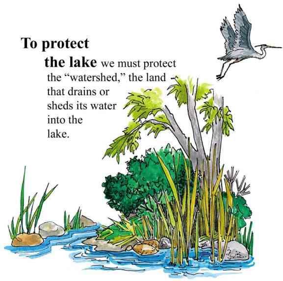
1 Big Bass Lake Eastern Marathon County Lake Study Final Study Results 2013 University of Wisconsin-Stevens Point and Marathon County Staff and Citizens Healthy lakes add value to our communities. They provide a place to relax and recreate, and can stimulate tourism. Like any infrastructure, lakes require attention and good management practices to remain healthy in developed watersheds. The purpose of this study is to learn about the current conditions of the fishery, habitat and aquatic ecosystems in order to help people make informed decisions to preserve what s good and correct any problems that exist.
2 1 P a g e


3 Big Bass Lake Location Big Bass Lake Township of Bevent Intersection of County Road Y and County Road C Surface Area: 180 acres Maximum Depth: 10 feet Water Flow Big Bass Lake is a seepage lake with most of the water entering the lake from groundwater. Surface water runoff and direct precipitation also contribute water, but to lesser extents. Water exits Big Bass Lake through groundwater. 2 P a g e


4 Big Bass Lake Surface Watershed Surface Watershed: The area where water runs off the surface of the land and drains toward the lake. Land uses and land management practices occurring in the watershed affect the water quality in the lake. Land uses and land management also play major roles in how water moves across the landscape and how much water soaks into the ground (for long-term storage) or quickly runs off the land. The surface watershed of Big Bass Lake is 1,568 acres. The primary land uses in the Big Bass Lake watershed are agriculture and forests. Big Bass Lake has residential development around much of its perimeter. In general, the land closest to the lake has the greatest immediate impact on water quality. 3 P a g e


5 Big Bass Lake Groundwater Watershed Groundwater Watershed: The area where water soaks into the ground and travels below ground to the lake. Groundwater slowly contributes water to our lakes throughout the year. Hard surfaces on the landscape prevent water from soaking into the ground and becoming groundwater. This results in less water flowing to the lake during the winter and between rains. The quality of groundwater reflects what is happening on the land surface. Precipitation falling on forested land produces clean groundwater, whereas precipitation falling on lands that have chemical use can leach contaminants to groundwater. Groundwater contamination in central Wisconsin may include nitrogen, pesticides, herbicides and other soluble chemicals originating from septic systems, crops, barnyards, road maintenance, etc. Once in the groundwater, these chemicals slowly move towards a lake or river. The groundwater watershed for Big Bass Lake is 463 acres. The primary land uses in the Big Bass Lake groundwater watershed are agriculture and forests. In general, the land adjacent to the lake where groundwater is flowing into the lake has the greatest immediate impact on water quality. Residential development and forests are adjacent to Big Bass Lake where most of the groundwater enters. Land Use Acres Agriculture 147 Developed 36 Forested 202 Roads 14 Recreational 4 Water 34 Wetland 26 Looking at Groundwater Up Close: Groundwater enters Big Bass Lake from the northwest and exits at various points around the lake. 4 P a g e

6 Big Bass Lake Shoreland Vegetation Shoreland vegetation is critical to a healthy lake s ecosystem. It provides habitat for aquatic and terrestrial animals including birds, frogs, turtles, and many small and large mammals. It also helps to improve the quality of the runoff that is flowing across the landscape towards the lake. Healthy shoreland vegetation includes a mix of tall grasses/flowers, shrubs and trees. The map below shows how far the 0.5 to 3 foot tall vegetation exists landward from the edge of Big Bass Lake. A greater vegetative buffer produces more habitat and better water quality. There are many areas around Big Bass Lake with minimal or no vegetative buffer. Restoring these areas would provide habitat and improve water quality. 5 P a g e

7 Big Bass Lake Lake Map Big Bass Lake s shape and depth play major roles in determining: Where aquatic plants can and cannot grow Types of fish and where they live How fast water in the lake warms up and cools down The water quality of the lake Abundance of habitat for species living in the water and on the land 6 P a g e


8 Big Bass Lake Fishery Many factors determine which fish species thrive in a lake. Physical factors include the lake s type, depth, surface area, geology and lake bed materials. Water quality in the lake also plays a role: water clouded with sediment or algae reduces the success of visual feeders, while low levels of dissolved oxygen will limit the fish population to those that can tolerate periods with low oxygen. Total catch and length of species in Big Bass Lake during the 2012 survey Big Bass Lake supports a warm water fish community. In 2012, nine fish species were identified out of the seventeen total species that have been recorded in Wisconsin DNR surveys dating back to Yellow bullhead and Iowa darter were newly documented species in the 2012 survey. The presence of young bass and abundant sunfish indicates successful reproduction is occurring in Big Bass Lake. Conclusions cannot be made about walleye and northern pike reproductive success without additional sampling efforts. 7 P a g e

9 Big Bass Lake Fishery Species occurrence in Big Bass Lake in 2012 and historical Wisconsin DNR records A variety of fish management techniques have been attempted at Big Bass Lake. In 1952, Wisconsin DNR fisheries biologists stocked the lake with walleye fry in an attempt to make Big Bass Lake into a walleye rearing pond. The effort was noted as a success and remaining walleye have done well. In 1957, the entire lake was treated with toxaphene to reset the system. The goal was to destroy the small panfish community then present and stock the lake with golden shiners, followed by northern pike (stocked in 1959). Historic stocking also included largemouth bass, smallmouth bass and black crappie. Winter kill events struck Big Bass Lake in 1964, 1975 and 1986, after which stocking efforts were discontinued. As a result of frequent winter fish kills, an aerator system was installed in 1988 to help maintain healthy dissolved oxygen levels during the winter months. 8 P a g e

10 Big Bass Lake Fishery Habitat in and near the lake plays a major role in the composition of a fish community. Habitat is a combination of aquatic plants, woody structure and lake substrate. Near the shore is found some of the most important fishery habitat. Coarse woody habitat (CWH) is an important component of a healthy and balanced fishery, playing a key role in the life histories of many fish species. Downed trees, logs and branches along with aquatic plants offer refuge from predators, sheltered substrates for spawning, nurseries for young, and feeding grounds to forage for insects and algae. CWH is very important to other animals that live in or visit a lake, such as turtles, frogs, birds and mammals. Coarse woody habitat is sparse in Big Bass Lake. The addition of CWH cover could benefit the fish community. Northern pike use areas with emergent and floating-leaf vegetation in shallow or flooded areas for spawning. Black crappie use bulrush habitat on gravel or sand substrates to construct nests and guard young. In the absence of sand and coarser substrates such as gravel, largemouth bass and sunfish are known to build nests on marl. Depressions are deepened until small amounts of coarser substrate, mostly fragments of snail shells, accumulate in the bottom of the nests. 9 P a g e
11 Big Bass Lake Aquatic Plants Aquatic plants are the forest landscape within a lake. They provide food for creatures including fish, ducks and turtles, and habitat for fish, invertebrates and other aquatic animals. They create oxygen in the water and utilize nutrients that would otherwise be used by algae. A healthy lake typically has a variety of aquatic plant species creating diversity that can help to prevent the establishment of aquatic invasive species. The 2012 aquatic plant survey of Big Bass Lake found no non-native plant species. This is a good indicator of overall aquatic health within the lake and demonstrates diligence by lake users in cleaning watercraft before entering the lake to prevent non-native species transfer. The aquatic plant community in Big Bass Lake is characterized by an above average diversity when compared to other lakes in the Marathon County study. The habitat, food source, and water quality benefits of this diverse plant community should be the focal points in future decision-making concerning lake management strategies. 10 P a g e


12 Big Bass Lake Aquatic Plants During the 2012 aquatic plant survey of Big Bass Lake, 55% of the sites sampled had vegetative growth. The average depth of sampled sites was 4 feet, with a maximum of 9 feet. The most common plant species in the survey was white-stem pondweed (Potamogeton praelongus), which is a good quality, native aquatic plant in Wisconsin. The greatest diversity in Big Bass Lake was found in the middle of the lake. Species Richness is a count of the number of plant species found at a survey point. A greater number of species in a lake helps to make the aquatic plant community more resilient to year-to-year changes and aquatic invasive species. More plant species means more diverse habitat and food sources are available. White-stem pondweed is an important source of food for waterfowl, muskrat, beaver and trout and also provides valuable habitat for muskellunge. This presence of this aquatic plant indicates good water quality due to its sensitivity to disturbances within the aquatic system. 11 P a g e
13 Big Bass Lake Aquatic Invasive Species Aquatic Invasive Species are non-native plants or animals that may cause significant harm to a lake s ecosystem. Typically, they are introduced to a lake by hitching a ride on clothing, boats, trailers and other water recreation equipment. Aquatic invasive species can be introduced to a lake accidentally or intentionally. Once in a lake, they may be impossible to completely remove and can be difficult and costly to control. Prevention and early detection are the best ways to keep aquatic invasive species from establishing in a lake. Lakes With Aquatic Invasive Species in Marathon and Northern Portage County, 2012 Lake Name Big Bass Lake Banded Mystery Snail Chinese Mystery Snail Rusty Crayfish Curly-Leaf Pondweed Eurasian Water Milfoil Marathon County (Shaded lakes are part of Eastern Marathon Co. Lake Study) Big Rib River Eau Claire Flowage Flume Creek Johnson Creek Lake Wausau Little Rib River Little Trappe River Lost Lake Mayflower Lake Purple Loosestrife Mission Lake Pike Lake Rice Lake South Branch Embarrass River Spring Brook Trappe River Wadley Lake Wausau Dam Lake Wisconsin River Northern Portage County Tree Lake Plover River Lake Du Bay Learn to identify invasive species & look for them in your lake! 12 P a g e


14 Big Bass Lake Water Quality Lakes go through a natural aging process that results in increased aquatic plant growth, fish and wildlife over time. Within a lake s watershed, human activity on the land, in a wetland, or in the lake can dramatically accelerate this process. Depending on land management practices, changes in a lake that may have normally taken centuries to occur may take place in decades or even years. The amounts of nutrients, algal growth, and water clarity measurements help to define the age of a lake. Based on these measures, lakes can be classified for comparison to one another. Oligotrophic Lakes Common uses: Swimming Skiing Boating Vegetation of oligotrophic lakes: Very little vegetation Mesotrophic Lakes Common uses: Boating Fishing Vegetation of mesotrophic lakes: Increased vegetation Occasional algal blooms Eutrophic Lakes Common uses: Fishing Wildlife watching Vegetation of eutrophic lakes: Lots of aquatic plants Frequent algal blooms Winter fish kills can occur in shallow lakes due to low oxygen levels. 13 P a g e

15 Big Bass Lake Water Quality Phosphorus is a major nutrient that can lead to excessive algae and rooted aquatic plant growth in lakes. In fact, one pound of phosphorus entering a lake can result 300 to 500 pounds of algal growth. All Marathon County lakes have either sufficient or excessive nutrients for aquatic plant growth, so these lakes will benefit from limiting the addition of more nutrients. Sources of phosphorus include septic systems, animal waste, storm water runoff, soil erosion, and fertilizers for lawns, gardens and agriculture. Total phosphorus levels measured when Big Bass Lake was well-mixed (overturn) are displayed in the graph to the left. Overturn sampling during the monitoring period indicate that Big Bass Lake is a mesotrophic lake with an average concentration of total phosphorus in the midrange. Water clarity is a measure of how deeply light can penetrate (Secchi depth). Clarity is affected by water color, turbidity (suspended sediment), and algae. Water clarity helps determine where rooted aquatic plants can grow. The graph to the left shows water clarity data collected during the growing seasons in 2011 and It is typical for water clarity to vary throughout the year. The 2011/2012 average Secchi depth readings were slightly deeper than historic averages, suggesting a possible recent improvement in water clarity. 14 P a g e

, green algae (Chlorophyta), and diatoms (Bacillariophyceae).")


16 Big Bass Lake Algae Algae are microscopic, photosynthetic organisms that are important food items in all aquatic ecosystems. Different algal groups increase or decrease during the year and they can be used to analyze a lake s water quality because there are more varieties of algae than fish or aquatic plants. Conclusions can be drawn about water temperature, nutrient availability, and overall water quality of a lake using algal populations. In Marathon County lakes, there are three dominant groups of algae: blue-green algae (Cyanobacteria), green algae (Chlorophyta), and diatoms (Bacillariophyceae). The 2011 and 2012 algal communities were diverse and primarily dominated by diatoms. The algal data found during the study period may indicate one of two possible shifts in water quality. The first possibility, supported by the lake s moderate total phosphorus value, is of a late-stage oligotrophic lake that is transitioning into a mildly mesotrophic lake. The second possibility, supported by the increase in water clarity, is that this is a moderately mesotrophic lake that is seeing some improvement in water quality conditions. Big Bass Lake displays many indicators of good or improving water quality. Two small but troubling indicators were identified that deserve continued attention: an increase in blue-green algae and a small green algae community of relatively few species. PERCENT ALGAL COMPOSITION FOR BIG BASS LAKE IN 2011 AND 2012 Blue-green algae have the widest tolerance range for temperatures and nutrient concentrations. A few varieties of blue-greens can produce toxins that are potentially harmful to livestock, pets and humans. 15 P a g e


.")
17 Big Bass Lake Sediment Core Analysis Lake sediment can help to tell the history of a lake and changes that may have affected the lake related to water quality, the abundance of aquatic plants, and sedimentation or land use changes in the watershed. These changes are assessed by evaluating the content of the upper layer of the sediment versus lower layers. This information can help to guide management decisions for a lake. Analysis of Big Bass Lake s sediment core suggests increased disturbance in the lake basin since the time of European land clearing. Over this time period, there have been increases in nutrients to the lake, including phosphorus, and substantial habitat changes. Elevated ragweed pollen counts found deeper in the core probably reflect early logging in the area; the peak of ragweed higher in the core indicates widespread transition to farming near the turn of the 20th century. Diatom species communities and sediment properties reflect an increase in phosphorus, aquatic plants and filamentous algae in the top of the sediment core. Properties at the top of the sediment core indicate that some shoreline stabilization has occurred in recent years. This sediment core was collected from Big Bass Lake. The darker layers indicate organic-rich sediments often due to increased growth of aquatic plants and/or soil erosion. Additional analysis of these layers can help to confirm the source(s). Diatoms are a type of algae commonly found in sediment. They are wellpreserved in sediments due to silica-based cell walls which resist degradation. Diatom species found in lake sediments in Marathon County. Different species of diatoms are sensitive to water quality; thus, changes in the diatom community from the bottom to the top of the sediment core can reveal how water quality in the lake has changed over time. Ragweed pollen 16 P a g e


18 Big Bass Lake What Can You Do? Lake Users: Run boat engines efficiently Observe no/low wake zones Refuel away from water Dispose of trash properly Remove all aquatic plants from boats and trailers Respect wildlife and other lake users Land Owners: Control soil erosion Keep livestock out of lakes and streams Control manure runoff Carefully manage nutrients and pesticides Leave natural shoreland vegetation in place or restore if it has been removed Learn to identify and look for invasive species Home Owners: Leave natural shoreland vegetation in place or restore if it has been removed Leave woody habitat for young fish, turtles and frogs Eliminate the use of fertilizer or use no phosphorus fertilizer Eliminate or minimize use of pesticides Control soil erosion Control runoff from rooftops and hard surfaces Clean up after pets Learn to identify and look for invasive species Stop the Spread of Aquatic Invasive Species! Wetlands and Shorelands: LEARN how to identify invasive plants and animals, and who to contact if found. DO NOT PURCHASE prohibited and restricted species! Whenever possible purchase native plants. NEVER transplant water garden plants or aquarium plants into lakes, streams, wetlands, or storm water ponds. Properly dispose of unwanted plants and animals! REMOVE invasive exotic plants from your landscape and replace them with native plants or non-invasive exotic plants. Scout annually for new invasive plants. AVOID using garden plants from other regions whose invasive potential is poorly understood. Lakes and Rivers: LEARN what Wisconsin invasive plants and animals look like and who to contact if seen in a lake or river INSPECT your boat, trailer and equipment when traveling to different water bodies and REMOVE any attached aquatic plants or animals (before launching, after loading, and before transporting on a public highway). DRAIN all water from boats, motors, and all equipment after use at a lake. NEVER release live fish, bait or pets into a wetland or water body. BUY minnows from a Wisconsin bait dealer. Only use leftover minnows at that same water body. 17 P a g e
 Aquatic Plants Jen McNelly (UW-Stevens Point) Cultural Survey Dr.")
 Christine Koeller (UW-Stevens Point) Sediment Core Dr.")
 Water Quality and Watersheds Nancy Turyk (UW-Stevens Point) Zooplankton")


19 Big Bass Lake Primary Researchers Algae Dr. Bob Bell (UW-Stevens Point) Aquatic Plants Jen McNelly (UW-Stevens Point) Cultural Survey Dr. Kristin Floress (UW-Stevens Point) Fisheries and Lake Maps Dr. Ron Crunkilton (UW-Stevens Point) and Dr. Justin Sipiorski (UW-Stevens Point) Christine Koeller (UW-Stevens Point) Sediment Core Dr. Samantha Kaplan (UW-Stevens Point) and Paul Garrison (Wisconsin DNR) Shoreland Assessments and Build Out Dan McFarlane (UW-Stevens Point) Water Quality and Watersheds Nancy Turyk (UW-Stevens Point) Zooplankton Dr. Chris Hartleb (UW-Stevens Point) Project support provided by: UW-Stevens Point Graduate and Undergraduate Students Wisconsin DNR Lake Protection grants UW-Stevens Point and UW-Stevens Point Faculty Marathon County Marathon County Citizens For more information about the study: UW-Stevens Point: Nancy Turyk, Marathon County: Shawn Esser, P a g e
Fish Community. Fish Habitat, Streams and Rivers
 Clear, Ston(e)y and White Lake Plan Fish Community The lakes support a cool/warm water fishery including muskellunge, walleye, largemouth and smallmouth bass, yellow perch, pumpkinseed, rockbass, blue
EcoLogic Memorandum. TO: Ben Brezell; EDR FROM: Mark Arrigo RE: Possible Impacts of Dredging Snooks Pond DATE: 6/4/07
 EcoLogic Memorandum TO: Ben Brezell; EDR FROM: Mark Arrigo RE: Possible Impacts of Dredging Snooks Pond DATE: 6/4/07 Background EDR P.C. (EDR) has been contracted by a landowner to assess the feasibility
Bear Lake. Final Results Portage County Lake Study. March 31, University of Wisconsin-Stevens Point, Portage County Staff and Citizens
 Bear Lake Final Results Portage County Lake Study March 31, 2005 University of Wisconsin-Stevens Point, Portage County Staff and Citizens What can you learn from this study? You can learn a wealth of valuable
Current Status and Management Recommendations for the Fishery in the Cloverleaf Chain of Lakes
 Current Status and Management Recommendations for the Fishery in the Cloverleaf Chain of Lakes Jason Breeggemann Senior Fisheries Biologist Wisconsin Department of Natural Resources Outline DNR fisheries
Aquatic Plant Management and Importance to Sport Fisheries
 Aquatic Plant Management and Importance to Sport Fisheries Presentation to Michigan Inland Lakes Convention May 2014 Mike Maceina Professor Emeritus School of Fisheries, Aquaculture, and Aquatic Sciences
Waupaca Chain O' Lakes Anonymous Stakeholder Survey Surveys Distributed: 804 Surveys Returned: 432 Response Rate: 54% Chain Property
 Waupaca Chain O' Lakes Anonymous Stakeholder Survey Surveys Distributed: 84 Surveys Returned: 432 Rate: 54% Chain Property 1. On which lake of the Chain do you reside or own property? Percent Columbia
BIG TWIN LAKE Kalkaska County (T28N, R05W, Section 18, and T28N, R06W, Section 13) Surveyed May 1999
 Surveyed May 1999") Michigan Department of Natural Resources Status of the Fishery Resource Report No. 2001-1, Year 2001 BIG TWIN LAKE Kalkaska County (T28N, R05W, Section 18, and T28N, R06W, Section 13) Surveyed May 1999
Michigan Department of Natural Resources Status of the Fishery Resource Report No. 2001-1, Year 2001 BIG TWIN LAKE Kalkaska County (T28N, R05W, Section 18, and T28N, R06W, Section 13) Surveyed May 1999
RECREATIONAL PONDS AND LAKES
 RECREATIONAL PONDS AND LAKES POND ECOLOGY AQUATIC PLANTS & FISH F.S. Conte Department of Animal Science University of California Davis Photos By Flickr AQUATIC PLANTS POND HEALTH Chemical Recycling Oxygen
Pond Management. Dan Lekie Agriculture & Natural Resource Agent K-State Research & Extension Johnson County
 Pond Management Dan Lekie Agriculture & Natural Resource Agent K-State Research & Extension Johnson County Pond Management Basics Plant ID and Control Fish Management Wildlife Concerns Management Options
MISSISSIPPI MAKEOVER A Plan for Restoration, Just Around the Bend
 MISSISSIPPI MAKEOVER A Plan for Restoration, Just Around the Bend Interim Report Card 2013 Project coordinated by the Dakota County Soil and Water Conservation District and sponsored by the Minnesota Pollution
Michigan Dept. of Natural Resources Status of the Fishery Resource Report Page 1. Weber Lake Cheboygan County, T34N, R3W, Sec.
 Michigan Dept. of Natural Resources 2012-143 Status of the Fishery Resource Report Page 1 Weber Lake Cheboygan County, T34N, R3W, Sec. 31 Neal Godby, Fisheries Biologist Environment Weber Lake is a 28.5-acre
SKIATOOK LAKE MANAGEMENT PLAN
 SKIATOOK LAKE MANAGEMENT PLAN Background Skiatook Lake impounds Hominy Creek, 5 miles west of Skiatook in Osage County, Oklahoma (Figure 1). Skiatook Lake covers 10,540 surface acres and was constructed
JadEco, LLC PO BOX 445 Shannon, IL 61078
 Introduction: With the assistance of Lake Holiday staff and volunteers, we were able to conduct an AC electrofishing survey on May 8, 27. Water temperatures were 2.3 C (8.5 F) and water clarity was decent
Lake Winnibigoshish Fisheries Information Newsletter
 Lake Winnibigoshish Fisheries Information Newsletter 03/21/2016 An annual fisheries newsletter for Lake Winnibigoshish In This Issue 2016 Population Assessment Invasive Species VHS Interesting Links Invasive
Introduction: JadEco, LLC PO BOX 445 Shannon, IL 61078
 Introduction: was contacted to collected data on the fishery for Lake Holiday. AC Electroshocking was conducted at 2 locations on September 28, 2015. Fish population data was collected for a total of 100
BENSON PARK POND FISH SPECIES
 BENSON PARK POND FISH SPECIES Bluegill (Lepomis macrochirus) From the Greek, lepomis means scaled gill cover and macrochirus means large hand, in reference to its body shape and size. Average adult size
SALINITY. It's the amount of dissolved salts the water contains.
 AQUATIC ECOSYSTEMS SALINITY The types of organisms in an aquatic ecosystem depend upon the water s Salinity. It's the amount of dissolved salts the water contains. Salinity determines the two main aquatic
Fisheries and Lake Management Planning. CAP Mtg Nov21,2012 Brett Tregunno Aquatic Biologist, Kawartha Conservation
 Fisheries and Lake Management Planning CAP Mtg Nov21,2012 Brett Tregunno Aquatic Biologist, Kawartha Conservation Outline Aquatic Habitat Types Fish Communities Significance of Resource Current Management
FACT SHEET MCGREGOR LAKE RESTORATION HABITAT PROJECT POOL 10, UPPER MISSISSIPPI RIVER, WISCONSIN ENVIRONMENTAL MANAGEMENT PROGRAM
 FACT SHEET MCGREGOR LAKE RESTORATION HABITAT PROJECT POOL 10, UPPER MISSISSIPPI RIVER, WISCONSIN ENVIRONMENTAL MANAGEMENT PROGRAM LOCATION McGregor Lake is located within a mid-river island in Pool 10
Aquatic Invasive Species in Douglas County Waterways
 Aquatic Invasive Species in Douglas County Waterways Saturday, March 28, 2009 Douglas County Fish & Game League Sport Show Wessman Arena, Superior, WI The Public Trust Wisconsin lakes and rivers are public
Caro Impoundment, Tuscola County
 Caro Impoundment is a 200 acre impoundment of the Cass River located one mile south of the Village of Caro in Tuscola County. Caro Dam, originally constructed in 1906 for water supply to Michigan Sugar
CORRESPONDENCE/MEMORANDUM
 CORRESPONDENCE/MEMORANDUM State of Wisconsin DATE: November 13, 2012 FILE REF: [Click here and type file ref.] TO: FROM: Mike Donofrio Harpt Lake File Steve Hogler SUBJECT: 2012 Harpt Lake Electrofishing
Crooked Lake Oakland County (T4N, R9E, Sections 3, 4, 9) Surveyed May James T. Francis
 Surveyed May James T. Francis") Michigan Department of Natural Resources Status of the Fishery Resource Report No. 2004-1, 2004 Crooked Lake Oakland County (T4N, R9E, Sections 3, 4, 9) Surveyed May 2002 James T. Francis Environment Crooked
Michigan Department of Natural Resources Status of the Fishery Resource Report No. 2004-1, 2004 Crooked Lake Oakland County (T4N, R9E, Sections 3, 4, 9) Surveyed May 2002 James T. Francis Environment Crooked
Fish Community and Aquatic Ecosystem Responses to the Cessation of Eurasian Watermilfoil Chemical Treatment on Lake Ellwood, Wisconsin
 Fish Community and Aquatic Ecosystem Responses to the Cessation of Eurasian Watermilfoil Chemical Treatment on Lake Ellwood, Wisconsin Greg G. Sass Wisconsin Department of Natural Resources Fisheries and
Overview of Recreational Pond Management
 Overview of Recreational Pond Management extension November 13 th 2013 Forrest Wynne State Extension Specialist for Aquaculture Kentucky State University Ponds are built for some of the following purposes:
Current projects for Fisheries Research Unit of Minnesota Department of Natural Resources
 Current projects for Fisheries Research Unit of Minnesota Department of Natural Resources MAJOR RESOURCE ISSUES IN THE DIVISION OF FISHERIES Status of Fish Populations To effectively manage fish populations,
LAKE MANAGEMENT PLAN
 LAKE MANAGEMENT PLAN Region Area DOW Number County DOW Lake Name Acreage 2 Duluth F213 69-0041 St. Louis Bassett DOW: 436 Plan: 442 Long Range Goal: Manage for walleye with a gillnet catch rate greater
2014 Island Lake Survey June 13 th, 2014 Andrew Plauck District Fisheries Biologist Report Prepared 4 March 2015
 2014 Island Lake Survey June 13 th, 2014 Andrew Plauck District Fisheries Biologist Report Prepared 4 March 2015 BACKGROUND - A fish survey was requested due to a moderately severe winterkill in Island
Upper/Lower Owl Creek Reservoir
 Upper/Lower Owl Creek Reservoir Schuylkill County 2018 Largemouth Bass Survey Upper Owl Creek Reservoir and Lower Owl Creek Reservoir are 67-acre and 26-acre impoundments, respectively, created by two
Onondaga Lake Fishery: 2011 Fact Sheet
 October, 2011 Onondaga County Department of Water Environment Protection SUNY College of Environmental Science and Forestry Joanne M. Mahoney, County Executive Tom Rhoads, P.E., Commissioner Onondaga Lake
13. POND HABITAT MANAGEMENT
 13. POND HABITAT MANAGEMENT A farm pond can provide years of enjoyment if it is carefully planned and managed. Figure 13.1 Hamilton Pond is an example of an excavated pond. While no current estimates exist
Aquatic Plant Point-Intercept Survey for Pike Lake, Scott County, Minnesota
 Campers on Pike Lake, Scott County, Minnesota, 2015 Aquatic Plant Point-Intercept Survey for Pike Lake, Scott County, Minnesota [Plant Survey Conducted August 24, 2015] Prepared for: Prior Lake/Spring
Marine Ecosystems. Aquatic Ecosystems Section 2
 Marine Ecosystems Marine ecosystems are located mainly in coastal areas and in the open ocean. Organisms that live in coastal areas adapt to changes in water level and salinity. Organisms that live in
FISHERIES BLUE MOUNTAINS ADAPTATION PARTNERSHIP
 FISHERIES A warming climate, by itself, substantially affects the hydrology of watersheds in the Blue Mountains. Among the key hydrologic changes projected under all scenarios for the 2040s and beyond
Leech Lake Update 5/20/2009 Walker Area Fisheries Office State Hwy. 371 NW Walker, MN
 Frequency (N) Leech Lake Update 5/20/2009 Walker Area Fisheries Office 07316 State Hwy. 371 NW Walker, MN 56484 218-547-1683 Greetings! This update is part of a series of reports the Minnesota Department
MEMORANDUM Comfort Lake-Forest Lake Watershed District
 MEMORANDUM Comfort Lake-Forest Lake Watershed District To: Board of Managers Date: December 7, 2016 From: Mike Kinney Subject: 2016 Watercraft Inspections and AIS Report Summaries Watercraft Inspection
Geology. Key Factors. Overfishing. Great Lakes Fishes. Historical Fishing. About 10,000 years since last glacial retreat very young ecologically
 Great Lakes Fishes Geology About 10,000 years since last glacial retreat very young ecologically Largest surface freshwater system on earth 21% of world s supply 84% of North America s supply Five unique
HUBBARD LAKE Alcona County (T27N, R7E; T28N, R7E) Surveyed May and September Tim A. Cwalinski
 Surveyed May and September Tim A. Cwalinski") Michigan Department of Natural Resources Status of the Fishery Resource Report No. 2003-1, 2003 HUBBARD LAKE Alcona County (T27N, R7E; T28N, R7E) Surveyed May and September 1996 Tim A. Cwalinski Environment
Michigan Department of Natural Resources Status of the Fishery Resource Report No. 2003-1, 2003 HUBBARD LAKE Alcona County (T27N, R7E; T28N, R7E) Surveyed May and September 1996 Tim A. Cwalinski Environment
Keuka Lake State of the Lake 2017
 Keuka Lake State of the Lake 2017 1 2 Lake Characteristics Third largest by area of the Finger Lakes 11,730 ac Deep and steep sided - max 185 ft mean 101 ft Two story fishery (warmwater/coldwater) 178,800
Ebert Lake 8 Lime Lake - 13
 8 - Number of responses Number of Responses Amount of Aquatic Plant Growth..5..5. Amount of aquatic plant growth.5 7. very_little right_amount dense_growth not_sure no_response 6 5 Dense_growth Choked_growth
I Region I Area I DOW Number / County I DOW Lake Name I Acreage I
 LAKE MANAGEMENT PLAN 814 Bp I Region I Area I DOW Number / County I DOW Lake Name I Acreage I I I # I f 2 Duluth F213 690036 St Louis Salo DOW:149 Plan: 137 Long Range Goal: Manage for walleye with a gillnet
What was the historic coaster fishery like?
 1 of 6 1/30/2012 12:25 PM Home About Topics Contact Us Fishing Calendar Fish ID Tips FAQs Hack Noyes Research Vessel Is it a unique strain long lost from Wisconsin's shoreline? Fisheries Reports Tributaries
Cat Island Chain Restoration
 Cat Island Chain Restoration 1820s Fox River Military Road Map to Fort Howard 1845 Chart of Green Bay & Fox River Cat Island Chain - 1938 Cat Island Brown County Aerial Photography, 1938 Historic Western
Examples of estuaries include bays, sounds, salt marshes, mangrove forests, mud flats, swamps, inlets, and sloughs.
 An estuary is a partially enclosed body of water where incoming seawater is mixed with fresh water coming from the land. Examples of estuaries include bays, sounds, salt marshes, mangrove forests, mud
From Phosphorus to Fish: Beneficial Use of Excess Nutrients
 FLOATINGISLANDINTERNATIONAL From Phosphorus to Fish: Beneficial Use of Excess Nutrients Project Location: Shepherd, Montana Fishing can be the primary method for transitioning excess nonpoint source nutrients
2010 Fishing Opener Prognosis. Central Region
 2010 Fishing Opener Prognosis Central Region Hinckley PINE COUNTY Pokegama, Cross, Island, Oak and North and South Big Pine Lakes are typically the best lakes for targeting walleye in Pine County. They
2018 New Hampshire Envirothon: Fish and Wildlife Test. 1. barred owl 13. Canada lynx. 2. bobolink 14. porcupine. 3. spring peeper 15.
 2018 New Hampshire Envirothon: Fish and Wildlife Test Score: Team #: Section I - Wildlife Identification (25 points - 1 point each) Calls Mammals 1. barred owl 13. Canada lynx 2. bobolink 14. porcupine
Clean Boats, Clean Waters. Watercraft Inspection Program
 Clean Boats, Clean Waters Watercraft Inspection Program Polk County: A Gathering of Waters 42 square miles of water 437 lakes 365 miles of rivers and streams 21,000 acres of wetlands Wisconsin: A Gathering
Oceans Humans both depend on it and threaten it with their activities
 Oceans Humans both depend on it and threaten it with their activities Oceans Water covers nearly ¾ of the Earth s surface More than 50% of the world s population lives within an hour of the coast Oceans
Crawford Reservoir. FISH SURVEY AND MANAGEMENT INFORMATION Eric Gardunio, Fish Biologist Montrose Service Center
 FISH SURVEY AND MANAGEMENT INFORMATION General Information: Crawford Reservoir is a popular fishery that provides angling opportunity for yellow perch, channel catfish, northern pike, rainbow trout, black
Cedar Lake Comprehensive Survey Report Steve Hogler and Steve Surendonk WDNR-Mishicot
 Cedar Lake- 2006 Comprehensive Survey Report Steve Hogler and Steve Surendonk WDNR-Mishicot ABSTRACT Cedar Lake is a 142 acre lake located in the southwest corner of Manitowoc County. It is a seepage lake
LAKE DIANE Hillsdale County (T8-9S, R3W, Sections 34, 3, 4) Surveyed May Jeffrey J. Braunscheidel
 Surveyed May Jeffrey J. Braunscheidel") Michigan Department of Natural Resources Status of the Fishery Resource Report No. 2003-4, 2003 LAKE DIANE Hillsdale County (T8-9S, R3W, Sections 34, 3, 4) Surveyed May 2001 Jeffrey J. Braunscheidel Environment
Michigan Department of Natural Resources Status of the Fishery Resource Report No. 2003-4, 2003 LAKE DIANE Hillsdale County (T8-9S, R3W, Sections 34, 3, 4) Surveyed May 2001 Jeffrey J. Braunscheidel Environment
Warm-up # 7 A day 5/17 - B day 5/18 UPDATE YOUR TABLE OF CONTENTS
 Warm-up # 7 A day 5/17 - B day 5/18 UPDATE YOUR TABLE OF CONTENTS Question: List all examples of surface water on Earth. Answer: Rivers and streams, lakes and reservoirs, (ponds) wetlands, estuaries and
LAKE MANAGEMENT PLAN
 LAKE MANAGEMENT PLAN Region 1 Area Park Rapids D.O.W. Number 29-185 County Hubbard D.O.W. Lake Name Big Sand Lake Class 22 Acreage 1,635 GIS 465 littoral LONG RANGE GOALS: Maintain or improve the quality
Brook Trout Life Cycle and Habitat
 Brook Trout Life Cycle and Habitat Directions: 1. As you watch this slide show, watch for vocabulary terms we learned today. The first time they appear, you will see them in RED! (not redd!) 2. At the
Ben Powell Clemson Extension
 Ben Powell Clemson Extension Maintain biological balance of the aquatic food web Serve as a functional reservoir for nutrients (and toxins) Provide control for aquatic weeds and biting flies Food source
1 of 5 1/8/2017 8:09 PM
 Three s: Pools Aquariums[2] Ponds[4] Water that is especially cloudy or turbid can be unhealthy, regardless of whether that water is in a pool, aquarium, or pond. Different problems can cause high turbidity,
FISH COMMUNITIES AND FISHERIES OF THE THOUSAND ISLANDS AND MIDDLE CORRIDOR
 St. Lawrence River Discussion Paper FISH COMMUNITIES AND FISHERIES OF THE THOUSAND ISLANDS AND MIDDLE CORRIDOR Issues Below is a synopsis of fish community issues and proposed management approaches. More
Fisheries Survey of White Rapids Flowage, Marinette County Wisconsin during Waterbody Identification Code
 Fisheries Survey of White Rapids Flowage, Marinette County Wisconsin during 25 Waterbody Identification Code 6343 Michael Donofrio Fisheries Supervisor Wisconsin Department of Natural Resources Peshtigo,
CARL BLACKWELL LAKE MANAGEMENT PLAN
 CARL BLACKWELL LAKE MANAGEMENT PLAN Background Lake Carl Blackwell impounds Stillwater Creek, 10 miles west of Stillwater in Payne County, Oklahoma (Figure 1). The lake covers 3,370 surface acres and was
First Nations Fish Habitat Program Discussion Workbook
 First Nations Fish Habitat Program Discussion Workbook The First Nations Fish Habitat Program is a joint initiative of the Centre for Indigenous Environmental Resources (CIER) and The Southern Chiefs Organization
MARTINDALE POND Wayne County 2004 Fish Management Report. Christopher C. Long Assistant Fisheries Biologist
 MARTINDALE POND Wayne County 2004 Fish Management Report Christopher C. Long Assistant Fisheries Biologist Fisheries Section Indiana Department of Natural Resources Division of Fish and Wildlife I.G.C.
Factors Affecting the Reproduction of Bluegill Bream and Largemouth Black Bass in Ponds
 CIRCULAR NO. 87FERAY14 FEBRUARY 1943 Factors Affecting the Reproduction of Bluegill Bream and Largemouth Black Bass in Ponds H-. S. SWINGLE, Fish C'ulturist and E. V. SMITH, Associate Botanist AGRICULTURAL
Booklet translated by SREJ at CSDC 1
 Name: Gr. : Booklet translated by SREJ at CSDC 1 This is the beginning of a new project about Aquaculture. Before we start, I would like to see what you already know about the subject. Write all the words
Tampier Lake Population Survey
 Located in Palos Park on 131 st St. between Wolf and Will-Cook Rd. s. Tampier Lake has 131 acres of fishable water, with a maximum depth of 9.4 feet. Walleye, northern pike, largemouth bass and channel
FACT SHEET I. LOCATION
 STEAMBOAT ISLAND HABITAT REHABILITATION AND ENHANCEMENT PROJECT (HREP) SCOTT COUNTY, IOWA, UPPER MISSISSIPPI RIVER RESTORATION-ENVIRONMENTAL MANAGEMENT PROGRAM ROCK ISLAND DISTRICT FACT SHEET I. LOCATION
Fish Texas AQUATIC ECOSYSTEMS
 27 Additionally, healthy aquatic communities in Texas rivers, reservoirs and estuaries provide unparalleled recreational opportunities to millions of Texans. Our fresh and saltwater environments vary from
Quemahoning Reservoir
 Pennsylvania Fish & Boat Commission Biologist Report Quemahoning Reservoir Somerset County May 2011 Trap Net, Gill Net and Electrofishing Survey Quemahoning Reservoir is an 899 acre impoundment located
Our foundation introduce Nature and conservation in Lake Izunuma Uchinuma.
 Our foundation introduce Nature and conservation in Lake Izunuma Uchinuma. The photo shows morning flight of greater white fronted geese. The geese leave their roosts for foraging at rice fields in the
Minnesota Department of Natural Resources Division of Fish and Wildlife Section of Fisheries. Stream Survey Report. Three Mile Creek 2011
 Minnesota Department of Natural Resources Division of Fish and Wildlife Section of Fisheries Stream Survey Report Three Mile Creek 2011 By Joseph D. Stewig Montrose Area Fisheries Office TABLE OF CONTENTS
NEVADA DEPARTMENT OF WILDLIFE STATEWIDE FISHERIES MANAGEMENT
 NEVADA DEPARTMENT OF WILDLIFE STATEWIDE FISHERIES MANAGEMENT FEDERAL AID JOB PROGRESS REPORTS F-2-52 216 CHIMNEY RESERVOIR WESTERN REGION NEVADA DEPARTMENT OF WILDLIFE, FISHERIES DIVISION JOB PROGRESS
Fish Survey of Goose Lake (ID # ), Ramsey County, Minnesota in 2012
, Ramsey County, Minnesota in 2012") Softshell Turtle from Goose Lake, July 2012 Fish Survey of Goose Lake (ID #62-0034), Ramsey County, Minnesota in 2012 Survey Dates: July 16-18, 2012 MnDNR Permit Number: 18362 Prepared for: VLAWMO and
Softshell Turtle from Goose Lake, July 2012 Fish Survey of Goose Lake (ID #62-0034), Ramsey County, Minnesota in 2012 Survey Dates: July 16-18, 2012 MnDNR Permit Number: 18362 Prepared for: VLAWMO and
Elk Lake, Antrim and Grand Traverse counties T. 28, 29 N., R. 8, 9 W., Sec. many. Lake surveys. began at 40 feet
 Elk Lake, Antrim and Grand Traverse counties T. 28, 29 N., R. 8, 9 W., Sec. many Physical and chemical data surveyed August 1931 Temperature ( F) Secchi disk (feet) 9. 6 Surface 74 Bottom 45 PH 8.0 Thermocline
Creation of Fish and Wildlife Habitat on the Closed Salmon Harbour Mine in Minto, NB
 Creation of Fish and Wildlife Habitat on the Closed Salmon Harbour Mine in Minto, NB M. Coleman 1, R. Rutherford 2, RA Currie 3 1 NB Power 2 Thaumas Environmental Consultants Ltd 3 RA Currie Ltd. Location
Habitat Stewardship Series n e w h a m p s h i r e w i l d l i f e a c t i o n p l a n
 Shorelines Habitat Stewardship Series n e w h a m p s h i r e w i l d l i f e a c t i o n p l a n Recognizing shoreline habitat The shorelines of lakes, ponds, and rivers are valuable real estate in New
Winter Drawdown Issues of Concern
 Winter Drawdown Issues of Concern Wetland Connectivity Amphibians Fisheries Winter Drawdown Wetland Connectivity Wetland complex near Osprey Creek is not responsive to lake level Wetland at upper end of
Minnesota Department of Natural Resources Division of Fish and Wildlife Section of Fisheries. Stream Survey Report. Luxemburg Creek.
 Minnesota F-29-R(P)-24 Area 315 Study 3 March 2016 Minnesota Department of Natural Resources Division of Fish and Wildlife Section of Fisheries Stream Survey Report Luxemburg Creek 2015 Mark Pelham Sauk
SOONER LAKE MANAGEMENT PLAN
 SOONER LAKE MANAGEMENT PLAN Background Lake Sooner impounds Greasy Creek, 15 miles south of Ponca City in Noble and Pawnee Counties, Oklahoma (Figure 1). The Grease Creek basin that Sooner Lake impounds
feeding - clear moderate-sized shallow streams with moderate vegetation spawning - nests in gravel, sand, or hard rock substrate
 orthern longear sunfish (Lepomis peltastes) feeding - clear moderate-sized shallow streams with moderate vegetation - rocky substrates - little to no current spawning - nests in gravel, sand, or hard rock
Tittabawassee River Assessment. Miles. Gladwin Smallwood Impoundment. Harrison. Clare. Midland. Mt. Pleasant. St. Louis. Saginaw.
 Warmouth Lepomis gulosus feeding - clear lakes and impoundments and very low-gradient streams - abundant aquatic vegetation - silt-free water - mucky substrate often covered with organic debris spawning
PRODUCING A TROPHY LARGEMOUTH BASS FISHERY (CASE STUDY) Greg Grimes President of Aquatic Environmental Services, Inc.
 Greg Grimes President of Aquatic Environmental Services, Inc.") PRODUCING A TROPHY LARGEMOUTH BASS FISHERY (CASE STUDY) Greg Grimes President of Aquatic Environmental Services, Inc. Background 32 acre lake in Harris County, Georgia o The construction of the lake began
PRODUCING A TROPHY LARGEMOUTH BASS FISHERY (CASE STUDY) Greg Grimes President of Aquatic Environmental Services, Inc. Background 32 acre lake in Harris County, Georgia o The construction of the lake began
Illinois Lake Management Association Conference March 23, 2018 By Trent Thomas Illinois Department of Natural Resources Division of Fisheries
 Illinois Lake Management Association Conference March 23, 2018 By Trent Thomas Illinois Department of Natural Resources Division of Fisheries Sources of Habitat Impairment Sedimentation Channelization
Rolling Knolls Pond Population Survey
 Located near the town of Elgin on the west side of Rohrssen Rd. between Illinois Route 58 and U.S.- 20. This small 1.8 acre pond has a maximum depth of 7.5 feet and is occasionally influenced by Poplar
AQUATIC PLANT MANAGEMENT PLAN
 AQUATIC PLANT MANAGEMENT PLAN JENNI AND KYLE PRESERVE PONDS TENNEY PARK LAGOON VILAS PARK LAGOON WARNER PARK LAGOON Lower Rock River Basin and VERONA QUARRY Grant-Platte-Sugar-Pecatonica Basin DANE COUNTY,
Name of Applicant Phone Number # Mailing Address. City State Zip
 VIRGINIA DEPARTMENT OF GAME AND INLAND FISHERIES EXOTIC SPECIES APPLICATION/PERMIT TO IMPORT CERTIFIED TRIPLOID GRASS CARP FOR AQUATIC VEGETATION CONTROL IN PRIVATE PONDS (Under Authority of 4 VAC 15-30-40
Summary of and Initial Response to public comments on MN Department of Natural Resources proposal to manage new waters for Muskellunge
 Summary of and Initial Response to public comments on MN Department of Natural Resources proposal to manage new waters for Muskellunge Summary of and Initial Response to public comments: This document
Bode Lake - South Population Survey
 Bode Lake - South Survey Located in Hoffman Estates on the north side of Bode Rd. 1 mile west of Barrington Rd. Bode Lake is made up of two lakes along Poplar Creek; the larger and deeper Bode Lake South
Alcona Dam Pond Alcona County (T25N, R5E, Sections various) Surveyed June 6-12 and September 16, 2003
 Surveyed June 6-12 and September 16, 2003") Michigan Department of Natural Resources Status of the Fishery Resource Report No. 2004-6, Year 2004 Alcona Dam Pond Alcona County (T25N, R5E, Sections various) Surveyed June 6-12 and September 16, 2003
Michigan Department of Natural Resources Status of the Fishery Resource Report No. 2004-6, Year 2004 Alcona Dam Pond Alcona County (T25N, R5E, Sections various) Surveyed June 6-12 and September 16, 2003
Managing a Quality Pond
 Managing a Quality Pond Gary Burtle The University of Georgia Successful Pond Management Set your GOAL Pond design Stocking Strategy Proper Nutrients Fish Growth and Harvest Successful Fish Reproduction
Sag Quarry - West Population Survey
 Located in Lemont on RT 83 and Archer Ave. just north of 111 th St. Like Sag Quarry East, this lake is an old limestone quarry, 14 acres in size and with a maximum depth of 10.3 feet. The species found
Status of Lake Erie s Western Basin Fish Populations: Trends and Environmental Conditions
 Status of Lake Erie s Western Basin Fish Populations: Trends and Environmental Conditions Jeff Tyson Ohio Department of Natural Resources Ohio Division of Wildlife Status of the Lake Erie s Western Basin
Shallow Lake Management Strategies. Steve McComas Blue Water Science Shallow Lakes Forum April 2014
 Shallow Lake Management Strategies Steve McComas Blue Water Science Shallow Lakes Forum April 2014 Shallow Lakes and Ponds Are Similar Shallow Lake Goal: Clear water and macrophytes. Clear Turbid Aquatic
Arrowhead Lake Population Survey
 Located in Palos Heights at 135 th St, east of Harlem Ave. Arrowhead Lake is a 13 acre body of water with a maximum depth of 12.6 feet. Fish species found in this lake include largemouth bass, bluegill,
NURSERY POND Fish Management Report. Jason C. Doll Assistant Fisheries Biologist
 NURSERY POND 2004 Fish Management Report Jason C. Doll Assistant Fisheries Biologist FISHERIES SECTION INDIANA DEPARTMENT OF NATURAL RESOURCES DIVISION OF FISH AND WILDLIFE I.G.C. South, Room W273 402
Michigan Department of Natural Resources Status of the Fishery Resource Report Page 1
 Michigan Department of Natural Resources 2007-33 Status of the Fishery Resource Report Page 1 Grand Sable Lake Alger County, T49N, R14W, Sec. Many Lake Superior watershed, last year surveyed 2004 James
CHECKS AND BALANCES. OVERVIEW Students become managers of a herd of animals in a paper-pencil, discussionbased
 CHECKS AND BALANCES 5 OVERVIEW Students become managers of a herd of animals in a paper-pencil, discussionbased activity. BACKGROUND White Tailed Deer White-tailed deer have always been a part of the forest
Busse Reservoir South Lateral Pool Population Survey
 Busse Reservoir South Lateral Pool Survey Located in Elk Grove Village south of Higgins Rd. between RT 53/I-290 and Arlington Heights Rd. Busse Reservoir is comprised of three pools making up a total of
Archer Lake 2011 Survey Report Prepared by Brian Gunderman
 Archer Lake 211 Survey Report Prepared by Brian Gunderman Introduction Archer Lake is a 64 acre lake located about miles southeast of the city of Coldwater. Archer Lake is part of the Coldwater-Marble
Fisheries Management Zone 10:
 Fisheries Management Zone 10: Lake Trout Operational Objectives and Management Photo Credit: www.jamessmedleyoutdoors.com 2 FMZ 10: Lake Trout Operational Objectives and Management Lake trout are the second
Water Habitat Model. Outcome: Materials: Teacher Instructions: : Identify the components of an animal habitat..
 Water Habitat Model Outcome: 4-1-03: Identify the components of an animal habitat.. Materials: Shoe boxes (1 per student) Art supplies: Glue and/or tape Paint and brushes for the background Plasticine/clay