Oceanography. Chapter 7 CIRCULATION PATTERNS AND OCEAN CURRENTS
|
|
|
- Audra McCoy
- 6 years ago
- Views:
Transcription
1 Oceanography Chapter 7 CIRCULATION PATTERNS AND OCEAN CURRENTS أ. راي د مرعي الخالدي
2 Circulation Patterns and Ocean Currents 7.1 Density-Driven Driven Circulation 7.2 Thermohaline Circulation 7.3 The Layered Oceans The Atlantic Ocean The Pacific Ocean 7.4 Measuring Water Properties 7.5 Wind-Driven Water Motion 7.6 Current Flow and Gyres 7.7 Ocean Surface Currents The Pacific Ocean The Arctic Ocean The Arctic Ocean The Indian Ocean The Atlantic Ocean The Indian Ocean 7.8 Open-Ocean Ocean Convergence and Divergence 7.9 Coastal Upwelling and Downwelling 7.10 Eddies 7.11 Measuring the Currents 7.12 Energy Sources Thermal Energy Harnessing the Currents Prepared by: Raed M.Khaldi
3 Circulation Patterns and Ocean Currents Major Concept (I) The oceans are not a single, homogeneous body of water. They actually consist of a number of distinct water masses characterized by different densities due to variations in temperature, salinity, and pressure. There is relatively little mixing between water masses. Different water masses can be identified in the oceans on the basis of changes in salinity and/or temperature. Changes in salinity, temperature, and pressure cause differences in density, resulting in the layering we see in seawater. The individual characteristics of water masses are determined at the surface by such processes as: a. the gain and loss of heat, Prepared by: Raed M.Khaldi
4 b. evaporation and precipitation patterns, c. the freezing and thawing ذوبان of sea ice, and d. surface currents generated by the wind. Major Concept (II) Vertical circulation in the oceans is usually the result of density differences in the water. The density of water is a function of salinity, temperature, and pressure. Because density is a function of several variables, it is possible to have several different water samples that have identical densities but different salinities and temperatures. Density will increase with decreasing temperature, increasing salinity, and increasing pressure or depth. Take a look at figure 7.1 to see how the same density water can be generated from different temperatures and salinities. For example, a water sample with a temperature of 5 C and a salinity of 32.9 ppt and a water sample with a temperature of 10 C and a salinity of 33.7 ppt will both have a density of g/cm 3.
5 Oceans are critically important in the movement of heat over the planet. In elementary school you learned that heat moves by conduction, convection, and radiation. Radiation and conduction are effective in moving heat vertically from the earth's surface, but are relatively unimportant in moving heat horizontally. Water, like air, is a fluid that can carry heat as it moves from one place to another. Meteorologists have different terms for horizontal and vertical movement of fluids: movement in the vertical direction is called convection,, and movement in the horizontal direction is called advection. Convection contributes, with radiation and conduction, to the movement of heat in the vertical direction. But advection is the essentially the sole process by which heat moves laterally over the surface of the earth.

6

7

8

9
10
11
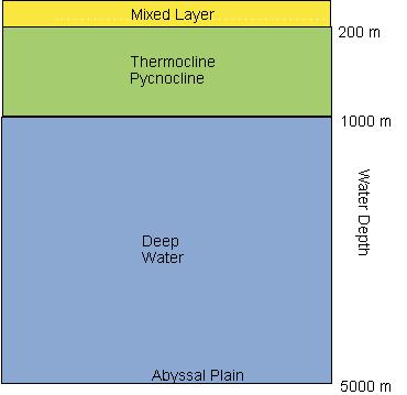
12 The upper 100 m (300 ft) or so of the oceans are usually fairly well-mixed by waves and currents. Within this surface mixed layer the density increases only slightly with depth due to increasing pressure. From about m ( ft) the temperature of the water drops quickly and the density increases as a result. Depending on where you are in the ocean basins, the salinity in this depth range may increase or decrease, but its influence will not be as great as the falling temperature. Below 1000 m the rate of decrease in temperature slows down dramatically. In these deep waters the temperature and salinity will change slowly and the major factor controlling density will be pressure. Typical vertical changes in temperature and salinity are shown in i figure 7.2. Vertical movement of water is the result of changes in the surface density of seawater.

13 Three main layers in the ocean:

14

15
16
17 Surface density is controlled in large part by climate patterns with latitude. In equatorial regions there is a lens of low density surface water at the surface due to warm temperatures and low salinity with the addition of fresh water by precipitation. The low density lens at the equator floats on top of higher density water that is generated near 30 N N and S where surface temperatures are slightly lower and increased evaporation over precipitation leads to higher salinity. At high latitudes, cold temperatures and increased salinity after the formation of sea ice create very high density water that sinks to the sea floor. The size of the water mass created in any region is related to the surface area of the region, the density of the water, and how rapidly the water is formed.
18 Major Concept (III) Thermo-haline circulation is the vertical movement of water caused by density differences that are related to changes in temperature and salinity. Vertical motion in the water column is controlled by the stability of the water column. If density increases with increasing depth, the water column is stable and there will be little vertical motion, or mixing. If density decreases with depth the water column will be unstable. The denser water will sink, or down well, and the lighter water will rise, or up well, until the column is stable again. This vertical motion is called overturn. If the density of the water is constant with depth the water column will have neutral density and the water will be easily mixed by waves, currents, and the wind. Thermo haline circulation ensures vertical mixing from the sea surface to the sea floor eventually.
19
20 The sinking of high density water in one area will displace an equal volume of lower density water elsewhere that will move upward in the water column. The stability of the water column can change seasonally in middle latitudes (see fig. 7.4). In the summer a stable column will form with low density, warm surface water. In the fall,الخريف and over the winter, the surface water will cool, increasing in density to the point where it can sink. Strong winter storms can increase the depth of mixing. In the open ocean seasonal changes in temperature have a greater impact on circulation than changes in salinity. In coastal regions large changes in salinity due to high volumes of freshwater runoff can be more important than temperature changes in regulating density. In semi-isolated basins the density of the water may be lowered by freshwater runoff in regions with high precipitation rates or raised by evaporation in dry climates.
21 At high latitudes the formation of sea ice in the winter concentrates the salts in the surface water because the large ions do not fit into the crystal structure of the ice. This creates very low temperature, high salinity water that sinks to the sea floor. The densest water on the deep sea floor is formed at the surface in the Weddell Sea of Antarctica. In regions of high evaporation, such as the Mediterranean Sea and the Red Sea, warm, saline water is produced with intermediate density that sinks to mid-depths in the open ocean. The speed at which water moves varies widely depending on the type of motion. Upwelling and down-welling motion occurs at rates of about (0.3-5 ft) per day. Fast surface currents move at speeds as great as 1.5 m per second, and deep horizontal thermohaline motion is about 0.01 cm (0.004 in) per second. Deep circulation is so slow that water may remain at depth for as much as 100 years before it rises to the surface again.
22 Major concept (IV) Salinity and temperature variations in the oceans are often controlled by thermohaline circulation and surface convergence and divergence patterns. Each ocean basin has its own characteristic pattern of water masses. THE ATLANTIC OCEAN General structure of the Atlantic Ocean is illustrated in figure 7.5. In the North Atlantic, the deepest water is called North Atlantic deep water. It has average salinity but high density due to very cold temperatures. This water is formed by the convergence of surface water. Surface water from high latitudes moves south and surface water from low latitudes moves north along the coast of North America and the two meet at about 60 N and sink, moving to the south at depth.
23 OCEANS OF THE WORLD Ocean Pacific Atlantic Indian Southern Arctic Surface Area mi ٢ km ٢ ٦٠ ٠٦٠ ٠٠٠ ١٥٥ ٥٥٧ ٠٠٠ ٢٩ ٦٣٧ ٠٠٠ ٧٦ ٧٦٢ ٠٠٠ ٢٦ ٤٦٩ ٠٠٠ ٦٨ ٥٥٦ ٠٠٠ ٧ ٨٤٨ ٠٠٠ ٢٠ ٣٢٧ ٠٠٠ ٥ ٤٢٧ ٠٠٠ ١٤ ٠٥٦ ٠٠٠ Of all oceans %٤٦ ٣ %٢٢ ٨ %٢٠ ٤ %٦ ١ %٤ ٢ Deepest Oceans and Seas
24 At about 30 N there is a shallow lens of salty, warm water at the surface. Water from the Mediterranean Sea flows through the Strait of Gibraltar جبل طارق and sinks to a depth of about 1000 m where it is stable. It flows across the Atlantic Ocean basin and can be identified by its high temperature and salinity. In equatorial regions the warm, low density surface water floats on top of Antarctic intermediate water. The Antarctic intermediate water is warmer and less saline than the North Atlantic deep water beneath it. Along the Antarctic coast the densest water in the oceans is formed. This water is called Antarctic bottom water. Its temperature is about -0.5 C and it has slightly higher than average salinity. The mid-ocean ridge system rises high enough above the surrounding sea floor to act like a dam for the bottom-hugging Antarctic bottom water. Antarctic bottom water is found on the western side of the Atlantic basin. North Atlantic deep water moves on top of the denser Antarctic bottom water and comes to the surface near 60 S in the region of Antarctic divergence.
25 South Atlantic surface water is simply that portion of the North Atlantic deep water that has surfaced at 60 S and moved toward the equator. THE ARCTIC OCEAN The Arctic Ocean is connected to the Atlantic Ocean between Spitsbergen and Greenland, and to the Pacific Ocean through the Bering Strait. The density of Arctic Ocean water is controlled more by salinity than temperature. Arctic Ocean surface water has a low salinity. It Is a mixture of low salinity water from the Bering Sea, fresh water runoff from Siberian and Canadian rivers, and seasonal melting of sea ice. - Salinity increases with depth where the water is a combination of North Atlantic water and high salinity water created by the seasonal formation of sea ice. - Water flows out of the Arctic Ocean into the North Atlantic to combine with Gulf Stream water to form North Atlantic deep water.
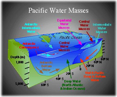
26 THE PACIFIC OCEAN The Pacific Ocean lacks a major source of deep water similar to the Atlantic. At high latitudes water sinks in relatively small areas of surface convergence and rapidly loses its identity. Small amounts of dense water are formed along the Antarctic coast. The deep water in the South Pacific comes from the circumpolar current flowing around Antarctica. There are surface lenses of warm, saline water in subtropical latitudes in the North and South Pacific. At depths below about 2000 m motion in the water is very slow and there are little changes in physical conditions in the water. THE INDIAN OCEAN The Indian Ocean is restricted to the Southern Hemisphere so there is no equivalent to North Atlantic deep water. Bottom water in the Indian Ocean is predominantly from the Antarctic circumpolar] The surface water of the Indian Ocean is warm and has an elevated salinity due to low precipitation and high evaporation
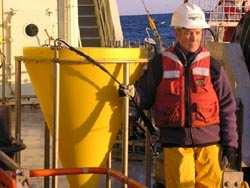
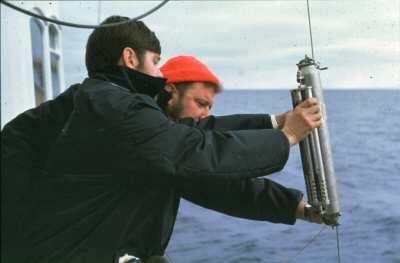
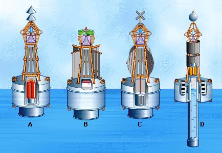
27 Major Concept (V) Special instruments are used to measure physical properties of seawater such as temperature and salinity. Until recently, samples of seawater were collected for chemical analysis using a series of bottles lowered to specific depths on a single wire. These were called Nansen bottles (see figure 7.7). Nansen bottles are open when they are lowered and closed when hit by a series of triggering weights that travel down segments of the wire between the bottles. Today, oceanographers use conductivity-temperature-depth (CTD) sensors to record temperature directly and compute salinity by measuring the electrical conductivity of the water (see figure 7.8). The measurements can be recorded electronically and sent directly to the ship or stored for future data retrieval. CTDs are particularly useful because of the large amounts of data they can collect.
28 CTDs can be left in place, suspended from a vessel or buoy, to measure salinity and temperature variations with time. Additional sensors can be attached to CTDs to measure variables such as oxygen concentration, nutrients, sound velocity, buoyancy, light transmission, and water transparency. CTDs are usually used from a stationary vessel but new models, such as Seasoar (see figure 7.9) can change depth while being towed behind a moving vessel. Independent instruments such as the SLOCUM glider (figure 7.10) and floats, or buoys, called profilers (figure 7.11) are able to monitor water properties in different areas and at different depths. They are designed to surface periodically and transmit their data to a ship or satellite. While newer electronic instruments can collect data more quickly, they still must be calibrated using results from older instruments like reversing thermometers and water samples collected with reversing bottles.


29 CTD device (Conductivity-Temperature-Depth)

30 sediment trap

31


32

33


34 Water Samplers Nansen Bottle (Allen Bottle) Surface Sample Bottle Van Dorn Bottle


35 Bottom Samplers corer
36 Major Concept (VI) Surface currents in the oceans are driven by winds. The major surface circulation patterns at sea are the result of the prevailing winds in the atmosphere. Prevailing winds in the atmosphere drive surface currents in the oceans in predictable patterns. Large circular surface currents called gyres dominate the winddriven surface circulation in each hemisphere. The major gyres in the Northern Hemisphere rotate clockwise while in the Southern Hemisphere they rotate counterclockwise. Imagine that the near surface water is actually composed of a number of thin layers lying on top of one another, each layer numbered with layer number 1 being at the surface. The blowing wind will drive the water in layer number 1. The water in layer number 2 will be driven by the motion of layer number 1. In a similar manner, each deeper layer is driven by the one above it. Prepared by: Raed M.Khaldi


37 These large mounds of water and the flow around them are called Gyres North Atlantic Gyre
38 Because the friction between the wind and layer number 1 is relatively small, and the friction between water layers is also small, the direction in which each layer moves will be influenced by the Coriolis effect. The surface water will be deflected at about 45 to the right of the direction of the wind. Each deeper layer of water will also be deflected to the right of the layer above it. With increasing depth there will be some loss of energy so the velocity of the motion will decrease. The net result is that the blowing wind will create motion in the water that decreases in velocity with depth and is deflected farther to the right (in the Northern Hemisphere) or to the left (in the Southern Hemisphere). If you could see this motion it would look like a spiral extending to a depth of about 150 m before motion stopped.this is called the Ekman spiral (fig. 7.12). At the base of the Ekman spiral the direction in which the water moves is actually opposite the direction in which the wind blows! The average direction in which water is being transported over the entire depth of the spiral is 90 to the right of the wind in the Northern Hemisphere and to the left of the wind in the Southern Hemisphere. This is called Ekman transport.

39 Ekman Transport
 is 90o to the right of the wind")
40 The net movement of water (averaged over the entire upper 330 meters of the ocean) is 90o to the right of the wind direction

41 Ekman spiral

42

43
44 Major Concept (VII) The large gyres that dominate surface circulation isolate lenses of low density water in their centers. In addition, currents on the western side of Northern Hemisphere ocean basins tend to be narrower and stronger than their counterparts on the eastern side. As the prevailing winds drive the large surface gyres, water is directed inward to the center of the gyres by Ekman transport. Ekman transport creates an elevated sea surface due to the piling up of the water. The difference in elevation is as much as 1 m (3 ft) or more. Gravity causes water to flow down the slopes of this elevated mound. The water will be deflected by the Coriolis effect and when everything is in balance there will be a circular rotation of water around the mound. Take a look at figure 7.14 to see an illustration of this phenomenon. The central water of surface gyres is isolated in the interior of the gyres.

45
46 The surface currents generated by the wind travel at speeds that are about 0.01 times the average wind speed. Typical speeds are on the order of m/s ( ft/s or knot). Current velocity will increase when large volumes of water are forced through narrow straits.مضايق An example would be the Florida Current moving out of the Gulf of Mexico and north along the coast of Florida. It moves at a speed of about 1.5 m/s. Major currents transport huge volumes of water. The volumes are so great that they are measured in units called Sverdrups. One Sverdrup = 1 million m 3 /s. The flow of the Gulf Stream is about 55 Sverdrups. Currents on the western side of Northern Hemisphere ocean basins are stronger than they are on the eastern side. This is known as western intensification and it is related to: a. the Coriolis effect, b. friction between the currents and land, and c. the piling up تكويم of water on the western side of the basin by the trade winds.

47

48
49

50
51 Western intensification is most pronounced in the Gulf Stream and Kuroshio currents in the Northern Hemisphere. Western intensification is not as pronounced in the Southern Hemisphere because the eastern currents are strengthened by water from the West Wind Drift that is deflected northward by the continents. Major Concept (VIII) The major surface currents are often given specific names to identify them. Figure 7.15 in the text locates the most important surface currents. THE PACIFIC OCEAN In the North Pacific the surface circulation in dominated by a clockwise rotating gyre formed by: a. the North Equatorial Current, b. the Kuroshio Current, c. the North Pacific Current, and d. the California Current.
52 This gyre is driven by the northeast trade winds and the westerlies. Further north in the North Pacific there is a smaller counterclockwise rotating gyre formed by: a. the North Pacific Current, b. the Alaska Current, and c. the Oyashio Current. In the South Pacific the surface circulation is dominated by a counterclockwise rotating gyre formed by: a. the South Equatorial Current, b. the East Australia Current, c. the northern edge of the West Wind Drift, and d. the Peru Current. This gyre is derived by the southeast trade winds and the westerlies. The North and South Pacific gyres lie on either side of 5 N due to the unequal heating of the surface between the two hemispheres. Prepared by: Raed M.Khaldi
53 Between these gyres is the Equatorial Counter Current flowing from west to east, returning some of the water driven toward the western Pacific. Figure 7.15 illustrates the characteristics of the average surface current movement over relatively long periods of time. Scientists have now started to investigate the existence of twenty to thirty year current and climate cycles in the Northeast Pacific, known as the Pacific Decadal Oscillation or PDO. THE ATLANTIC OCEAN In the North Atlantic there is a similar clockwise rotating gyre formed by: a. the North Equatorial Current, b. the Gulf Stream, c. the North Atlantic Current, and d. the Canary Current. In the South Atlantic the counterclockwise rotating gyre is formed by: a. the South Equatorial Current, b. the Brazil Current, c. the northern edge of the West Wind Drift, and d. the Benguela Current.
54 The Atlantic gyres are also displaced north of the equator by a small distance. There is a weak Equatorial Counter Current in the Atlantic on the eastern side of the ocean basin. On the western side there is a net flow of water from the Southern Hemisphere to the Northern at the surface. Recent studies have found evidence of cyclical changes in circulation in the North Atlantic called the North Atlantic Oscillation. This is similar to the Pacific Decadal Oscillation. The North Atlantic Oscillation is characterized by pools of warm and cool surface water with life spans of four to ten years that circle the North Atlantic. Cold, low salinity surface water appears to produce colder than average winters in northern Europe and North America. It also affects the rate of formation of North Atlantic deep water. THE ARCTIC OCEAN In the Arctic Ocean the polar easterlies drive a large clockwise gyre (fig. 7.16). A small amount of water enters the Arctic Ocean from the Pacific Ocean through the Bering Strait. Arctic Ocean water exits north of Greenland as the East Greenland Current and flows into the North Atlantic.
55 The West Greenland Current joins the Labrador Current to carry water south along the Canadian coast. Most Atlantic water flows east above Norway and Finland and then across Siberia's Arctic coast. THE INDIAN OCEAN Because the Indian Ocean is primarily a Southern Hemisphere ocean, its surface circulation is dominated by a counterclockwise rotating gyre formed by: a. the South Equatorial Current, b. the Agulhas Current, c. the northern edge of the West Wind Drift, and d. the West Australian Current. The waters north of the equator in the Indian Ocean move to the east in the summer and to the west in the winter with the seasonal changes in monsoon winds. Without any continents to block its flow the West Wind Drift is the only continuous current flowing around the globe. It moves from west to east around Antarctica. Other major surface currents can be seen in figure 7.15.
56 Major Concept (IX) Zones of open ocean surface convergence and divergence mark regions of sinking and rising water respectively. Thermohaline circulation and wind driven surface currents combine to create areas of surface convergence and divergence in the open ocean. Sinking surface water is replaced by lower density water that flows into the region of sinking. This is called surface convergence. Low density water that rises to the surface will spread out and move away in a process called surface divergence. Other areas of surface convergence and divergence are caused by blowing wind along continental margins and in the open ocean. Figure 7.17 illustrates the locations of permanent zones of surface convergence and divergence.
57 Surface convergence in the open ocean occurs at:, الكساد a. 0 in the tropical convergence beneath the doldrums b N and S in the subtropical convergences, c. 50 N and S in the Arctic and Antarctic convergences, and d. the coastal Antarctic convergence at 60 S. - Sinking water in zones of convergence carries oxygen from the surface to greater depth. - Surface divergence in the open ocean occurs in three areas: a. on either side of the tropical convergence, and b. in the Antarctic divergence. - In regions of surface divergence deep water comes to the surface carrying high concentrations of nutrients and dissolved gas that promote high levels of biological productivity. - The velocity of vertically moving water is quite low ( m/day) compared to the velocity of wind-driven surface currents (1.5 m/s).
58 Thermohaline circulation of deep bottom water is very slow. Typical velocities are about 0.01 cm/s. Convergences and divergences also produce water mixing. Converging surface water masses mix to produce a new water mass of intermediate salinity and temperature that have slightly greater density and sink to intermediate levels where they then move out horizontally and eventually rise to the surface again elsewhere. Thermohaline circulation and wind-driven surface currents are very closely related and of roughly equal importance. The exact nature of ocean circulation changes with time. Over long time scales, changes in the configuration of the continents creates changes in the shapes of ocean basins. Over shorter time scales, changes in climate from glacial to interglacial periods will influence circulation. Present day circulation of surface and deep water is shown in figure 7.18.
59 Major Concept (X) Regions of coastal upwelling and downwelling can be created by prevailing wind directions. Upwelling and down-welling can also be generated by winds causing Ekman transport of water away from or toward continental margins respectively. Regions of upwelling often have high biological productivity as cold, deep water rich in dissolved gas and nutrients comes to the surface to support plant growth. Regions of nearly permanent upwelling are found on the eastern sides of ocean basins. These areas are very rich fishing grounds. Along some coasts seasonal changes in wind direction cause alternating upwelling and down-welling. An example would be the northwest coast of the United States, as illustrated in figure 7.19.

60

61

62
 winds generate a southward surface flow and a consequent offshore Ekman transport inducing upwelling ٤ ٢.")
63 Figure Main features of the upwelling-favorable wind conditions off west coast of Vancouver Island during the summer. Northerly North Pacific High (NPH) winds generate a southward surface flow and a consequent offshore Ekman transport inducing upwelling ٤ ٢. Main features of wind-induced downwelling off the west coast of Vancouver Island during the winter. Southerly Aleutian Low (AL) winds generate a northward drift and a consequent onshore Ekman transport (modified after Thomson, 1981.(
64 Zones of convergence and divergence increase the mixing of different water masses to create new water masses of intermediate temperature and salinity. Major Concept (XI) Currents do not generally flow in smooth curves or straight lines. Current paths will meander and sometimes close on.دوامات themselves to form eddies When currents twist and close on themselves they can trap water from one side of the current on the opposite side. An excellent example of this is shown in figures 7.20 and 7.21 in the case of the Gulf Stream. These trapped parcels of water will rotate and retain their individual characteristics for weeks or months with little mixing. They are called eddies. Eddies can form at the surface or at depth. Eddies can vary from tens to hundreds of kilometers in diameter.
65 Major Concept (XII) Currents can be measured using either stationary instruments or instruments designed to float and move along with the current. Moving water at any depth can be monitored using specially designed buoys طوافات or floats whose density can be changed to keep the instrument at a specific depth. Data from the instrument can then be relayed to a ship. Surface buoys can also be tracked with satellites or photography to determine speed and direction of travel (see fig. 7.22). Surface currents can be seen more readily if a dye is released into them. Older style current meters record water velocity with a rotor and direction with a vane (see fig. 7.23a). The current meter is often submerged to remove the effect of wind and waves (see fig. 7.24a).
66 Modern current meters measure current speed and direction using sound waves (See fig. 7.23b). Narrow frequency sound beams are emitted in four directions. The sound waves will reflect off of small particles carried by the currents. If the water is moving away from the instrument the frequency of the echo will be lower than the original frequency. If the water is moving toward the instrument the frequency of the echo will be higher than the original frequency. This is known as the Doppler Effect. To determine current direction and speed the measurements from all four directions are combined and compared to an internal compass.
67 Major Concept (XIII) There is a tremendous amount of energy available in the oceans due to the high heat capacity and the constant motion of the water. The oceans are heated from above by incoming solar radiation. Consequently, surface water is appreciably warmer than water at depth. The extraction of thermal energy from the water is the objective of OTEC (Ocean Thermal Energy Conversion) systems (fig. 7.25). There are two types of OTEC systems, closed cycle and open cycle. OTEC systems depend on the difference in temperature between surface water and water at a depth of m ( ft). In the closed OTEC system, heat is extracted from warm surface water to vaporize a working fluid like ammonia or freon. This vapor is stored under pressure and used to drive a turbine. Cold deep water is pumped to condense the vapor and the process is repeated.
68 In the open OTEC system, warm surface water is placed in a low pressure chamber where a small fraction of it will be converted to steam to drive a turbine and generate power. The steam will then be condensed through contact with cold water pumped from below. The condensed water will be fresh water. In order to generate more power than the amount required to run the system there must be a temperature difference in the water of at least 20 C. The best location for an OTEC plant would be somewhere between about 25 N and S latitude where seawater temperatures over depth average 22 C. Engineers studying the efficiency of OTEC systems estimate that they would produce an amount of usable power per square km of ocean surface equal to about 0.07% of the average absorbed solar energy over that area. There may be unknown side effects related to pumping cold deep water to the surface. This water is typically enriched in nutrients which would be liberated in the nutrient poor tropical surface water.
69 There is a land-based open-system OTEC plant in Hawaii that produces useable energy and desalinated water. The nutrient - rich deep water is used in a variety of aquaculture projects and as a coolant to provide air-conditioning at the plant. Surface currents also represent huge reservoirs of energy that could be harnessed. One method that has been proposed would be to anchor large turbines in the path of a current. The moving water would turn the turbines and generate electricity just as hydroelectric power plants do at dams. There are some problems associated with extracting energy from currents, including: a. most currents move too slowly, b. many currents are not located near where the energy would be needed the most, and c. the cost of any such product is currently greater than the value of the energy. Prepared by: Raed M.Khaldi

70 World ocean thermohaline circulation

71 Layers of the Ocean

72
73
74
75

76 tsunamis
77

78
79 OCEANS OF THE WORLD

80
81

82

83
84

85
 and salinity (haline.")
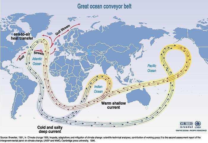
86 There is global circulation which extends to the depths of the sea called the Great Ocean Conveyor. Also called the thermohaline circulation, it is driven by differences in the density of the sea water which is controlled by temperature (thermal) and salinity (haline.( The route of the deep water flow is through the Atlantic Basin around South Africa and into the Indian Ocean and on past Australia into the Pacific Ocean Basin.If the water is sinking in the North Atlantic Ocean then it must rise somewhere else
87

88 Figure :Polar and subtropical jet streams

89 Seaplane station markers
90
91

92 anemometer Measuring wind speed and direction

93 ASW buoys
94 Surface drifting buoys Many hundreds of surfaces drifting buoys have been dropped in the tropical Pacific as part of the international Surface Velocity Program These buoys are equipped with a thermistor chain providing temperature data in the upper 20 m; regular positioning via Argos satellite provides estimates of surface current. Prepared by: Raed M.Khaldi

95 Current Meters

96 Ocean Thermal Energy Conversion (OTEC )

97 OPEN OTEC systems
98 The surface water and the deep water of tropical ocean can be used respectively as the heat source and the heat sink of a thermal engine ruled by the Carnot principle. The main components of the system are: Pumps and pipes for supplying the evaporator and the condenser respectively with warm and cold sea water; a working fluid which is vaporized to drive a steam turbine which generates mechanical energy. This mechanical energy can be transformed The details of the process and the technology of the components for OTEC systems depend essentially on the choice of the working fluid. There are basically two types of OTEC processes: the closed-cycle cycle and the open-cycle. In the closed-cycle cycle process the heat from the warm surface sea water is transferred through the evaporator to a working fluid, such as ammonia, at the temperature of the available warm sea water to t turn it to vapor. The expanding vapor drives a turbo alternator, which produces electricity. Cold sea water passing through a condenser containing the vaporized working fluid turns the vapor back into a liquid which is then recycled through the system in a close cycle. Prepared by: Raed M.Khaldi
99 Open-cycle OTEC uses the warm surface water itself as the working fluid. In an evaporator under near vacuum, the water vaporizes at surface water temperatures. The expanding vapor drives a low-pressure turbine attached to a generator which produces electricity. The vapor, which is indeed i fresh water vapor, is condensed back into liquid water by exposure to cold temperature from deep ocean water. If the surface condenser keeps the vapor from direct contact with h sea water, the condensed water can then be used for drinking water or o irrigation. A direct contact condenser that mixes the vapor and the cold sea water is more thermodynamically efficient but the effluent is salty and not recycled. The process is repeated with a continuous supply of surface sea water to the evaporator. The cycle of the working fluid is open. Variations of OTEC open cycle, include mist lift and foam lift processes, p which use a hydraulic turbine instead of the very low vapor pressure steam turbine used in the OTEC open cycle have been proposed and tested ed at a small scale in the laboratory. Hybrid systems use parts of both open and closed-cycle cycle systems to optimize the co-production of electricity and fresh water. Prepared by: Raed M.Khaldi

100 PHOTO CAPTION: Conceptual illustration of future Ocean Thermal Energy Conversion plant by Ocean Power Plant.Such plants would generate electric power that could be used to make hydrogen and fresh water. Other potential ancillary activities could include aquaculture, deep sea mining and even rocket launch services.

101

102

103
EARTH, PLANETARY, & SPACE SCIENCES 15 INTRODUCTION TO OCEANOGRAPHY. LABORATORY SESSION #6 Fall Ocean Circulation
 EARTH, PLANETARY, & SPACE SCIENCES 15 INTRODUCTION TO OCEANOGRAPHY LABORATORY SESSION #6 Fall 2017 Ocean Circulation The focus of the Lab this week is circulation of the ocean and atmosphere. Here, you
Introduction to Oceanography OCE 1001
 Introduction to Oceanography OCE 1001 Lecture Notes Chantale Bégin & Jessica Fry Version 2.1 10. Ocean Circulation (Trujillo, Chapter 7) Major ocean currents are stable and predictable; they have been
CHAPTER 7 Ocean Circulation
 1 2 3 4 5 6 7 8 9 10 11 12 13 14 CHAPTER 7 Ocean Circulation Words Ocean currents Moving seawater Surface ocean currents Transfer heat from warmer to cooler areas Similar to pattern of major wind belts
Lesson: Ocean Circulation
 Lesson: Ocean Circulation By Keith Meldahl Corresponding to Chapter 9: Ocean Circulation As this figure shows, there is a connection between the prevailing easterly and westerly winds (discussed in Chapter
Ocean Currents that Redistribute Heat Globally
 Ocean Currents that Redistribute Heat Globally Ocean Circulation Ocean Currents Fig. CO7 OCEAN CURRENTS Surface ocean currents are similar to wind patterns: 1. Driven by Coriolis forces 2. Driven by winds
Role of the oceans in the climate system
 Role of the oceans in the climate system heat exchange and transport hydrological cycle and air-sea exchange of moisture wind, currents, and upwelling gas exchange and carbon cycle Heat transport Two Primary
10% water in the world is tied up in the surface ocean currents. (above the pycnocline) Primary source is wind: Westerlies, Trades, Polar Easterlies
 Primary source is wind: Westerlies, Trades, Polar Easterlies") Oceanography Chapter 9 10% water in the world is tied up in the surface ocean currents. (above the pycnocline) Primary source is wind: Westerlies, Trades, Polar Easterlies Coriolis deflects winds (and
Oceanography Chapter 9 10% water in the world is tied up in the surface ocean currents. (above the pycnocline) Primary source is wind: Westerlies, Trades, Polar Easterlies Coriolis deflects winds (and
Currents & Gyres Notes
 Currents & Gyres Notes Current A river of water flowing in the ocean. 2 Types of Currents Surface Currents wind-driven currents that occur in the top 100m or less Deep Currents density-driven currents
Ocean Circulation. Si Hui Lee and Frances Wen. You can access ME at
 Ocean Circulation Si Hui Lee and Frances Wen You can access ME at http://tinyurl.com/oceancirculation Earth - the blue planet - 71% area covered by the oceans - 3/4 of ocean area between 3000-6000m deep
Chapter 9: Circulation of the Ocean
 Chapter 9: Circulation of the Ocean Tropical gardens on Britain s Scilly Isles. Only 48 kilometers (30 miles) off the coast of Cornwall at 50 N, these scenic islands lie in the path of the warm waters
Chapter 22, Section 1 - Ocean Currents. Section Objectives
 Chapter 22, Section 1 - Ocean Currents Section Objectives Intro Surface Currents Factors Affecting Ocean Currents Global Wind Belts (you should draw and label a diagram of the global wind belts) The Coriolis
The Ocean is a Geophysical Fluid Like the Atmosphere. The Physical Ocean. Yet Not Like the Atmosphere. ATS 760 Global Carbon Cycle The Physical Ocean
 The Physical Ocean The Ocean is a Geophysical Fluid Like the Atmosphere Three real forces: Gravity Pressure gradients Friction Two apparent forces: Coriolis and Centrifugal Geostrophic & Hydrostatic balances
Directed Reading. Section: Ocean Currents. a(n). FACTORS THAT AFFECT SURFACE CURRENTS
. FACTORS THAT AFFECT SURFACE CURRENTS") Skills Worksheet Directed Reading Section: Ocean Currents 1. A horizontal movement of water in a well-defined pattern is called a(n). 2. What are two ways that oceanographers identify ocean currents? 3.
Skills Worksheet Directed Reading Section: Ocean Currents 1. A horizontal movement of water in a well-defined pattern is called a(n). 2. What are two ways that oceanographers identify ocean currents? 3.
IX. Upper Ocean Circulation
 IX. Upper Ocean Circulation World Ocean Covers 71% of Earth s surface Contains 97% of surface water Arctic Ocean NH: 61% ocean, 39% land Pacific Ocean Atlantic Ocean Southern Ocean Indian Ocean SH: 81%
Agronomy 406 World Climates
 Agronomy 406 World Climates January 30, 2018 Monsoons. Ocean properties and circulation. Review for today: Online textbook: 1.3.1 (Sea water) Composition and properties. For Thursday: Rahmstorf, S.: The
Wednesday, September 27, 2017 Test Monday, about half-way through grading. No D2L Assessment this week, watch for one next week
 Wednesday, September 27, 2017 Test Monday, about half-way through grading No D2L Assessment this week, watch for one next week Homework 3 Climate Variability (due Monday, October 9) Quick comment on Coriolis
Winds and Ocean Circulations
 Winds and Ocean Circulations AT 351 Lab 5 February 20, 2008 Sea Surface Temperatures 1 Temperature Structure of the Ocean Ocean Currents 2 What causes ocean circulation? The direction of most ocean currents
Air Pressure and Wind
 Air Pressure and Wind 19.1 Understanding Air Pressure Air Pressure Defined Air pressure is the pressure exerted by the weight of air. Air pressure is exerted in all directions down, up, and sideways. The
Midterm Exam III November 25, 2:10
 Midterm Exam III November 25, 2:10 25, 2:10 3:25 pm, HW714 Chapters 7 (7.12 7.17), 8 and 9 (through section 9.15, included) 60 multiple choice questions this exam constitutes 22% (only) of your total (overall)
Assessment Schedule 2016 Earth and Space Science: Demonstrate understanding of processes in the ocean system (91413)
") NCEA Level 3 Earth & Space Science (91413) 2016 page 1 of 6 Assessment Schedule 2016 Earth and Space Science: Demonstrate processes in the ocean system (91413) Evidence Statement Q Evidence with with Excellence
NCEA Level 3 Earth & Space Science (91413) 2016 page 1 of 6 Assessment Schedule 2016 Earth and Space Science: Demonstrate processes in the ocean system (91413) Evidence Statement Q Evidence with with Excellence
Chapter. Air Pressure and Wind
 Chapter Air Pressure and Wind 19.1 Understanding Air Pressure Air Pressure Defined Air pressure is the pressure exerted by the weight of air. 19.1 Understanding Air Pressure Air Pressure Defined Air pressure
Duckies have been found in Hawaii, Alaska, S. America, Scotland, Washington state and Australia as of 2012.
 Duckies have been found in Hawaii, Alaska, S. America, Scotland, Washington state and Australia as of 2012. We learned that it takes 3 years to complete one circuit of the North Pacific Gyre flow in the
Ocean Layers. Based on sunlight penetration: Based on water density: Sunlight (photosynthesis is possible) Twilight Midnight
 Twilight Midnight") PART 3 Ocean Layers Based on sunlight penetration: Sunlight (photosynthesis is possible) Twilight Midnight Based on water density: Mixed layer Pycnocline (rapid change of themperature/salinity) Deep ocean
PART 3 Ocean Layers Based on sunlight penetration: Sunlight (photosynthesis is possible) Twilight Midnight Based on water density: Mixed layer Pycnocline (rapid change of themperature/salinity) Deep ocean
170 points. 38 points In your textbook, read about modern oceanography. For each item write the word that meets the description.
 Ch 15 Earth s Oceans SECTION 15.1 An Overview of Oceans 38 points In your textbook, read about modern oceanography. For each item write the word that meets the description. (5 points) 1. German research
Ocean Motion. Ocean Currents. Before You Read. Read to Learn
 chapter 18 3 Ocean Motion section 2 Ocean Currents What You ll Learn the Coriolis effect what influences surface currents the temperature of coastal waters about density currents Before You Read Imagine
Deep Water Currents Lab
 Deep Water Currents Lab Background: Anyone visiting the seashore is struck by the constant motion of water traveling on the surface of the ocean in the form of waves. But beneath the ocean's surface, water
OCN 201 Surface Circulation
 OCN 201 Surface Circulation Excess heat in equatorial regions requires redistribution toward the poles 1 In the Northern hemisphere, Coriolis force deflects movement to the right In the Southern hemisphere,
W3 Global Circulation Systems
 W3 Global Circulation Systems Which regions of Earth receive the most energy from the Sun? If not for global circulation systems There would only be two narrow regions that would support life What
Section 1. Global Wind Patterns and Weather. What Do You See? Think About It. Investigate. Learning Outcomes
 Chapter 5 Winds, Oceans, Weather, and Climate Section 1 Global Wind Patterns and Weather What Do You See? Learning Outcomes In this section, you will Determine the effects of Earth s rotation and the uneven
Monday, October 2, Watch for new assessment (Week 4/5 review) TA s have your tests, please see key (at course website)
 TA s have your tests, please see key (at course website)") Monday, October 2, 2017 Watch for new assessment (Week 4/5 review) TA s have your tests, please see key (at course website) Homework 3 Due date Wednesday, Oct 11 (8 pm) Be ready to watch another important
Monday, October 2, 2017 Watch for new assessment (Week 4/5 review) TA s have your tests, please see key (at course website) Homework 3 Due date Wednesday, Oct 11 (8 pm) Be ready to watch another important
OCEANOGRAPHY STUDY GUIDE
 OCEANOGRAPHY STUDY GUIDE Chapter 2 Section 1 1. Most abundant salt in ocean. Sodium chloride; NaCl 2. Amount of Earth covered by Water 71% 3. Four oceans: What are they? Atlantic, Pacific, Arctic, Indian
1 Currents. TAKE A LOOK 2. Read a Map In what direction does the Gulf Stream flow?
 CHAPTER 5 1 Currents SECTION The Movement of Ocean Water BEFORE YOU READ After you read this section, you should be able to answer these questions: What factors affect ocean currents? Why are ocean currents
OCN201 Spring14 1. Name: Class: Date: True/False Indicate whether the statement is true or false.
 Name: Class: _ Date: _ OCN201 Spring14 1 True/False Indicate whether the statement is true or false. 1. Short residence time elements are uniformly distributed in the oceans 2. Thermohaline circulation
Meteorology I Pre test for the Second Examination
 Meteorology I Pre test for the Second Examination MULTIPLE CHOICE 1. A primary reason why land areas warm up more rapidly than water areas is that a) on land, all solar energy is absorbed in a shallow
OCN 201, Chemistry & Physics Section
 , A 1-April-2015 Name: Answer the True/False and Multiple Choice questions on the scantron sheet. Answer the remaining questions on this exam handout. Turn in both the scantron and exam at the end of class.
Section 6. The Surface Circulation of the Ocean. What Do You See? Think About It. Investigate. Learning Outcomes
 Chapter 5 Winds, Oceans, Weather, and Climate Section 6 The Surface Circulation of the Ocean What Do You See? Learning Outcomes In this section, you will Understand the general paths of surface ocean currents.
Quiz name: Oceanography - Land and Sea Interaction - Quiz #2
 Name: Quiz name: Oceanography - Land and Sea Interaction - Quiz #2 ate: 1. What is the direction of spin for gyres in the northern hemisphere? clockwise counter clockwise northern oscillation southern
Chapter 6: Atmospheric Pressure, Wind, and Global Circulation
 Discovering Physical Geography Third Edition by Alan Arbogast Chapter 6: Atmospheric Pressure, Wind, and Global Circulation Factors That Influence Air Pressure Air Pressure is the measured weight of air
Chapter 10 Lecture Outline. The Restless Oceans
 Chapter 10 Lecture Outline The Restless Oceans Focus Question 10.1 How does the Coriolis effect influence ocean currents? The Ocean s Surface Circulation Ocean currents Masses of water that flow from one
OCEANOGRAPHY 101. Map, and temperature, salinity & density profiles of the water column at X, near mouth of the Columbia River.
 OCEANOGRAPHY 101 EXAM 2 WINTER 00 NAME STUDENT NUMBER 1 Map, and temperature, salinity & density profiles of the water column at X, near mouth of the Columbia River. P a c i f i c O c e a n X WA Columbia
Ocean Currents Unit (4 pts)
") Name: Section: Ocean Currents Unit (Topic 9A-1) page 1 Ocean Currents Unit (4 pts) Ocean Currents An ocean current is like a river in the ocean: water is flowing traveling from place to place. Historically,
Name: Section: Ocean Currents Unit (Topic 9A-1) page 1 Ocean Currents Unit (4 pts) Ocean Currents An ocean current is like a river in the ocean: water is flowing traveling from place to place. Historically,
Zonal (East-West) Currents. Wind-Driven Ocean Currents. Zonal (East-West) Currents. Meridional (N-S) Currents
 Currents. Wind-Driven Ocean Currents. Zonal (East-West) Currents. Meridional (N-S) Currents") Wind-Driven Ocean Currents Similarities between winds & surface currents Zonal (East-West) Currents Trade winds push currents westward north & south of the equator Equatorial currents. Up to 100 cm/sec.
Wind-Driven Ocean Currents Similarities between winds & surface currents Zonal (East-West) Currents Trade winds push currents westward north & south of the equator Equatorial currents. Up to 100 cm/sec.
9/25/2014. Scales of Atmospheric Motion. Scales of Atmospheric Motion. Chapter 7: Circulation of the Atmosphere
 Chapter 7: Circulation of the Atmosphere The Atmosphere: An Introduction to Meteorology, 12 th Lutgens Tarbuck Lectures by: Heather Gallacher, Cleveland State University Scales of Atmospheric Motion Small-
SIO20 - Midterm Examination 2 v1 Winter Section A. Circle the letter corresponding to the best answer. (1 point each)
") NAME: Section A. Circle the letter corresponding to the best answer. (1 point each) 1. Rainbows result from: a. refraction and reflection of sunlight by water droplets b. reflection of sunlight by oceans
NAME: Section A. Circle the letter corresponding to the best answer. (1 point each) 1. Rainbows result from: a. refraction and reflection of sunlight by water droplets b. reflection of sunlight by oceans
Lornshill Academy. Geography Department Higher Revision Physical Environments - Atmosphere
 Lornshill Academy Geography Department Higher Revision Physical Environments - Atmosphere Physical Environments Atmosphere Global heat budget The earth s energy comes from solar radiation, this incoming
ATS150: Global Climate Change. Oceans and Climate. Icebergs. Scott Denning CSU 1
 The Oceans Wind-Driven Gyre Circulations Icebergs Scott Denning CSU 1 Surface Balance of Forces friction coriolis wind stress resultant current Wind stress accelerates surface water Friction couples surface
Atmosphere & Weather. Earth Science
 Atmosphere & Weather Earth Science Energy Transfer in the Atmosphere Earth s energy is provided by the SUN! Energy is important to us because it 1. Drives winds and ocean currents. 2. Allows plants to
18.1 Understanding Air Pressure 18.1 Understanding Air Pressure Air Pressure Defined Measuring Air Pressure Air pressure barometer
 18.1 Understanding Air Pressure 18.1 Understanding Air Pressure Air Pressure Defined Air pressure is the pressure exerted by the weight of air. Air pressure is exerted in all directions down, up, and sideways.
9.3. Storing Thermal Energy. Transferring Thermal Energy
 9.3 If you have been to a beach on a hot summer day, you have likely cooled off by going for a dip in the water. The water, which is cooler than you are, removes thermal energy from your body, making you
The Surface Currents OCEA 101
 The Surface Currents OCEA 101 Why should you care? - the surface ocean circulation controls the major ocean biomes - variations in ocean circulation control the supply of nutrients for marine organisms
Sailing the Seas: Wind Driven Ocean Circulation Ocean Gyres
 Sailing the Seas: Wind Driven Ocean Circulation Ocean Gyres Ocean Currents What Happens at the Coast? Readings: Ch 9: 9.2-9.6, 9.8-9.13 Graphic: America's Cup sailboat race off Newport, Rhode Island. J.
Water on Earth. How do oceans relate to weather and the atmosphere? Solar Radiation and Convection Currents
 Earth is often called the Blue Planet because so much of its surface (about 71%) is covered by water. Of all the water on Earth, about 96.5% is held in the world s oceans. As you can imagine, these oceans
Ocean Current Worksheet
 Ocean Current Worksheet Temperature Affects and Surface Currents: Surface waters of the Earth s oceans are forced to move, primarily by winds. Where winds blow in the same direction for a long period of
Review for the second quarter. Mechanisms for cloud formation
 Review for the second quarter Mechanisms for cloud formation 1 Rising air expands and cools; Sinking air compresses and warms. (18) (24) Dry adiabatic lapse rate (10 o C/km): the rate of temperature decrease
Lecture 13 El Niño/La Niña Ocean-Atmosphere Interaction. Idealized 3-Cell Model of Wind Patterns on a Rotating Earth. Previous Lecture!
 Lecture 13 El Niño/La Niña Ocean-Atmosphere Interaction Previous Lecture! Global Winds General Circulation of winds at the surface and aloft Polar Jet Stream Subtropical Jet Stream Monsoons 1 2 Radiation
Lecture 5.1 Surface Ocean Circulation. Image from Daily Mail Newspaper, UK
 Lecture 5.1 Surface Ocean Circulation Image from Daily Mail Newspaper, UK Announcements Midterm is Thursday, consists of 25 multiple choice, 3 pages short answer questions No Scantron needed Calculators,
Oceans and the Global Environment: Lec 2 taking physics and chemistry outdoors. the flowing, waving ocean
 Oceans and the Global Environment: Lec 2 taking physics and chemistry outdoors the flowing, waving ocean Peter Rhines 1 Eric Lindahl 2 Bob Koon 2, Julie Wright 3 www.ocean.washington.edu/courses/has221a-08
Name Date L.O: SWBAT explain what breezes, planetary winds, ocean currents & monsoons are.
 Name Date L.O: SWBAT explain what breezes, planetary winds, ocean currents & monsoons are. 1. A cool breeze is blowing toward the land from the ocean on a warm, cloudless summer day. This condition is
El Niño Lecture Notes
 El Niño Lecture Notes There is a huge link between the atmosphere & ocean. The oceans influence the atmosphere to affect climate, but the atmosphere also influences the ocean, which can also affect climate.
Write about this. Have you ever experienced a very strong wind gust? What happened? Have you ever felt a gentle breeze? What did it feel like?
 Write about this. Have you ever experienced a very strong wind gust? What happened? Have you ever felt a gentle breeze? What did it feel like? How wind works Winds flow on earth based on differences in
Prevailing Winds. The Coriolis Effect
 Prevailing Winds 1. Wind: a movement of air in the atmosphere. Bill Nye wind (2 minutes) 2. Local or regional wind: occur in fairly small areas. 3. Prevailing winds: Major wind pattern that affect large
Lecture Outlines PowerPoint. Chapter 18 Earth Science 11e Tarbuck/Lutgens
 Lecture Outlines PowerPoint Chapter 18 Earth Science 11e Tarbuck/Lutgens 2006 Pearson Prentice Hall This work is protected by United States copyright laws and is provided solely for the use of instructors
OCN-201 Chemistry and Physics section
 Name: Class: _ Date: _ OCN-201 Chemistry and Physics section True/False Indicate whether the statement is true or false. 1. Because of the dissolved salt in seawater its freezing point is lower than that
Lesson: Atmospheric Dynamics
 Lesson: Atmospheric Dynamics By Keith Meldahl Corresponding to Chapter 8: Atmospheric Circulation Our atmosphere moves (circulates) because of uneven solar heating of the earth s surface, combined with
Figure 8.8. Figure Oceanography 10 Ocean Circulation. Gulf Stream flows at 55 million cubic meters/sec, 500 times the flow of the Amazon River
 Oceanography 10 Ocean Circulation PART 1: Introduction General types of Ocean Currents Solar Energy and the Seasons PART 2: Measuring Ocean Currents and Structure PART 3: General Surface Currents and their
Lecture 15 General Circulation of the Atmosphere and Ocean
 Lecture 15 General Circulation of the Atmosphere and Ocean Non-rotating model of atmospheric general circulation Hadley (1735) Cell is induced by uneven distribution of solar heating. Conceptual models
Lecture The Oceans
 Lecture 22 -- The Oceans ATMOSPHERE CIRCULATION AND WINDS Coriolis effect Prevailing winds and vertical circulation Zones of pressure, evap. & ppt. Factors modifying global winds -- Differential heating
The Movement of Ocean Water. Currents
 The Movement of Ocean Water Currents Ocean Current movement of ocean water that follows a regular pattern influenced by: weather Earth s rotation position of continents Surface current horizontal movement
6.1 Introduction to Weather Weather air mass Weather factors Temperature Pressure What is wind? Wind Convection in the atmosphere Thermals thermal
 6.1 Introduction to Weather Weather is a term that describes the condition of the atmosphere in terms of temperature, atmospheric pressure, wind, and water. The major energy source for weather events is
Introduction to Physical Oceanography STUDENT NOTES Date: 1. What do you know about solar radiation at different parts of the world?
 Introduction to Physical Oceanography STUDENT NOTES Date: 1 Warm up What do you know about solar radiation at different parts of the world? What affect does the tilt of the Earth have on the northern and
The ocean water is dynamic. Its physical
 CHAPTER MOVEMENTS OF OCEAN WATER The ocean water is dynamic. Its physical characteristics like temperature, salinity, density and the external forces like of the sun, moon and the winds influence the movement
3 Global Winds and Local Winds
 CHAPTER 1 3 Global Winds and Local Winds SECTION The Atmosphere BEFORE YOU READ After you read this section, you should be able to answer these questions: What causes wind? What is the Coriolis effect?
ESCI 107 The Atmosphere Lesson 11 Global Circulation
 Reading: Meteorology Today, Chapter 10 THE GLOBAL CIRCULATION ESCI 107 The Atmosphere Lesson 11 Global Circulation Latitudinal heat imbalance The tropics receive more radiation than they emit. The polar
SURFACE CURRENTS AND TIDES
 NAME SURFACE CURRENTS AND TIDES I. Origin of surface currents Surface currents arise due to the interaction of the prevailing wis a the ocean surface. Hence the surface wi pattern (Figure 1) plays a key
Ocean Currents Shortcut method by to learn faster
 Ocean Currents Shortcut method by to learn faster In our geography notes on the hydrosphere, we have seen the major movements of the ocean water. They are waves, tides and ocean currents. Having covered
Ocean Currents Shortcut method by to learn faster
 Ocean Currents Shortcut method by to learn faster In our geography notes on the hydrosphere, we have seen the major movements of the ocean water. They are waves, tides and ocean currents. Having covered
Atmosphere Circulation
 Atmosphere Circulation Winds What Causes Winds? Difference in air pressure due to unequal heating of the atmosphere. Temperatures vary according to the amount of sun it gets. Uneven heating of the Earth
Current: large mass of continuously moving ocean water
 Ocean Currents Current: large mass of continuously moving ocean water Surface Currents--Wind Circulation These waters make up about 10% of all the water in the ocean. These waters are the upper 400 meters
ESS15 Lecture 12. Review, tropical oceans & El Nino, and the thermohaline ocean circulation. Please see new reading material on website.
 ESS15 Lecture 12 Review, tropical oceans & El Nino, and the thermohaline ocean circulation. Please see new reading material on website. Review. I-clicker exercise: In this graph of Earth s energy imbalances
McKnight's Physical Geography 11e
 Chapter 2 Lecture McKnight's Physical Geography 11e Lectures Chapter 5 Atmospheric Pressure and Wind Michael Commons Ohio Northern University Atmospheric Pressure and Wind The Nature of Atmospheric Pressure
Greenhouse Effect Activity
 Greenhouse Effect Activity Objectives: The student will: 1. Read and use weather instruments. 2. Collect and record temperature readings. 3. Describe the concept of the greenhouse effect. Materials: Fish
Atmospheric & Ocean Circulation-
 Atmospheric & Ocean Circulation- Overview: Atmosphere & Climate Atmospheric layers Heating at different latitudes Atmospheric convection cells (Hadley, Ferrel, Polar) Coriolis Force Generation of winds
Ocean Motion Notes. Chapter 13 & 14
 Ocean Motion Notes Chapter 13 & 14 What is a Wave? Wave: movement of energy through a body of water How are Waves Caused? Caused mostly by wind Wind blowing on the water transmits energy to the water Size
Earth s oceans covers 71 % _ of the planet s surface. In reality, Earth s ocean waters are all. interconnected as part of a single large global ocean.
 Ocean Motion Met 101: Introduction to the World's Oceans Produced by The COMET Program Geography: Name Pd. Earth s oceans covers 71 % _ of the planet s surface. In reality, Earth s ocean waters are all
Lecture 13. Global Wind Patterns and the Oceans EOM
 Lecture 13. Global Wind Patterns and the Oceans EOM Global Wind Patterns and the Oceans Drag from wind exerts a force called wind stress on the ocean surface in the direction of the wind. The currents
Lecture 13 March 24, 2010, Wednesday. Atmospheric Pressure & Wind: Part 4
 Lecture 13 March 24, 2010, Wednesday Atmospheric Pressure & Wind: Part 4 Synoptic scale winds Mesoscale winds Microscale winds Air-sea interactions The largest synoptic scale wind. Monsoon: Arabic for
The atmospheric circulation system
 The atmospheric circulation system Key questions Why does the air move? Are the movements of the winds random across the surface of the Earth, or do they follow regular patterns? What implications do these
Wind and Air Pressure
 Wind and Air Pressure When air moves above the surface of the Earth, it is called wind. Wind is caused by differences in air pressure. When a difference in pressure exists, the air will move from areas
Chapter: Atmosphere Section 3: Air Movement
 Table of Contents Chapter: Atmosphere Section 3: Air Movement We will learn about Air Movement=Wind -Why different latitudes on Earth will receive different amounts of Solar Energy -The Coriolis Effect
SIO 210 Final examination Wednesday, December 11, PM Sumner auditorium Name:
 SIO 210 Final examination Wednesday, December 11, 2013 2-5 PM Sumner auditorium Name: Turn off all phones, ipods, etc. and put them away. This is a closed book exam. You may use one page of notes, both
3 Global Winds and Local Winds
 CHAPTER 15 3 Global Winds and Local Winds SECTION The Atmosphere BEFORE YOU READ After you read this section, you should be able to answer these questions: What causes wind? What is the Coriolis effect?
6.9B verify through investigations that thermal energy moves in a predictable pattern from warmer to cooler 6.5B recognize that a limited number of
 6.9B verify through investigations that thermal energy moves in a predictable pattern from warmer to cooler 6.5B recognize that a limited number of elements comprise the largest portion of oceans and atmosphere
Air moves towards ITCZ in tropics because of rising air - convection. Horizontal extent of Hadley cell is modified by Friction Coriolis Force
 Air moves towards ITCZ in tropics because of rising air - convection Horizontal extent of Hadley cell is modified by Friction Coriolis Force Speed from rotation Objects at rest on Earth move at very different
3/22/11. General Circulation of the Atmosphere. General Circulation of the Atmosphere
 Chapter 10 General refers to the average air flow, actual winds will vary considerably. Average conditions help identify driving forces. The basic cause of the general circulation is unequal heating of
THE ATMOSPHERE. WEATHER and CLIMATE. The Atmosphere 10/12/2018 R E M I N D E R S. PART II: People and their. weather. climate?
 R E M I N D E R S Two required essays are due by Oct. 30, 2018. (A third may be used for extra credit in place of a Think Geographically essay.) ESSAY TOPICS (choose any two): Contributions of a noted
Friday, February 8 th. Winds/Coriolis Worksheet: Due Today Lab Worksheet: Finish Questions
 Ocean Currents Friday, February 8 th Winds/Coriolis Worksheet: Due Today Lab Worksheet: Finish Questions Non-rotating Earth Convection cell model Add rotation and add landmasses unequal heating and cooling
Summary of Lecture 10, 04 March 2008 Introduce the Hadley circulation and examine global weather patterns. Discuss jet stream dynamics jet streams
 Summary of Lecture 10, 04 March 2008 Introduce the Hadley circulation and examine global weather patterns. Discuss jet stream dynamics jet streams arise because the Coriolis force prevents Hadley-type
Read each slide, some slides have information to record on your organizer. Some slides have numbers that go with the question or red and underlined
 Read each slide, some slides have information to record on your organizer. Some slides have numbers that go with the question or red and underlined to use for answering the questions. Essential Question:
Lecture Outlines PowerPoint. Chapter 15 Earth Science, 12e Tarbuck/Lutgens
 Lecture Outlines PowerPoint Chapter 15 Earth Science, 12e Tarbuck/Lutgens 2009 Pearson Prentice Hall This work is protected by United States copyright laws and is provided solely for the use of instructors
(20 points) 1. ENSO is a coupled climate phenomenon in the tropical Pacific that has both regional and global impacts.
 1. ENSO is a coupled climate phenomenon in the tropical Pacific that has both regional and global impacts.") SIO 210 Problem Set 4 Answer key December 1, 2014 Due Dec. 12, 2014 (20 points) 1. ENSO is a coupled climate phenomenon in the tropical Pacific that has both regional and global impacts. (2 points) a)
SIO 210 Problem Set 4 Answer key December 1, 2014 Due Dec. 12, 2014 (20 points) 1. ENSO is a coupled climate phenomenon in the tropical Pacific that has both regional and global impacts. (2 points) a)