REPORT OF IN HOUSE WORKSHOP ON BENTHIC HABITAT MAPPING ON BOARD M.V. SEAFDEC 2
|
|
|
- Adela May
- 5 years ago
- Views:
Transcription


1 REPORT OF IN HOUSE WORKSHOP ON BENTHIC HABITAT MAPPING ON BOARD M.V. SEAFDEC September 2012 TD/RP/163
2 REPORT OF IN HOUSE WORKSHOP ON BENTHIC HABITAT MAPPING ON BOARD M.V. SEAFDEC September 2012 Referring to the recommendations made at the Expert Meeting on Deep Sea Fishing and Its Impact on Ecosystem 1 that SEAFDEC is requested to find best practice of the sampling gears for deep sea fisheries resources. Over the years, SEAFDEC/TD has explored ways to utilize the deep sea fisheries resources in Southeast Asian Region through improvement of so called environmental friendly sampling gears, including mid water trawl, gillnet, and bottom vertical longline. It was also suggested through the series of activities related to deep sea fisheries resources exploration in the Southeast Asian Region that technical information/knowledge and experience on bathygraphic mapping (fisheries resources mapping) should be transferred to the Member Countries in order to provide an alternative source of fisheries resources from the deep sea waters of the Member Countries with science based information, particularly on the vulnerable marine ecosystem of their respective waters. In respond to this, SEAFDEC TD has developed a set of equipment ready to be put into the trial before transferring such knowledge and technology to the Member Countries. Subsequently, SEAFDEC/TD plans to organize Regional training workshop on benthic habitat mapping scheduled in the third quarter of 2012, of which the tools 2 for resources mapping are needed to be trailed. With this regard, SEAFDEC/TD proposes to carry out the in house workshop on the benthic habitat mapping on board M.V. SEAFDEC 2. Objectives: System testing preparing benthic habitat mapping including: Underwater VDO camera ROV Side Scanning Sonar Echo Sounder and Bottom trawl Participant s 1. Ms Penchan Laongmanee Coordinator 2. Asst.Prof. Pachoenchoke Jintasaeranee(Ph.D.) Resource person (Lecturer from Burapa University) 3. Dr. Natinee Sukramongkol Participant 4. Mr. Sukchai Arnupapboon,, 5. Mr. Narong Ruangsivakul,, 6. Mr. Sayan Promjinda,, 7. Mr. Nakaret Yasook,, 8. Mr. Suchart Kitsamut,, 9. Mr. Komson Pofa,, 10. Dr. Taweekiet Amornpiyakrit,, 11. Dr. Nopporn Manajit,, 12. Mr. Weerasak Yingyuad,, 1 organized under project deep sea fisheries resources exploration in the Southeast Asia during 31 August 2 September
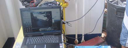
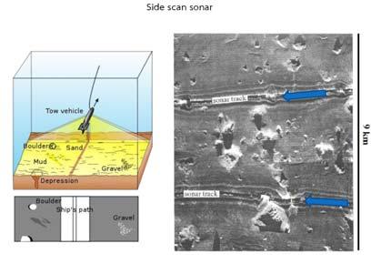
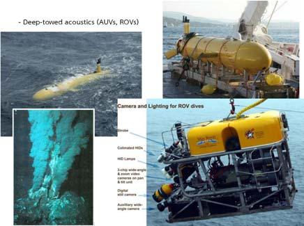
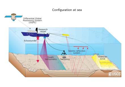
3 Activities summary Lecture Two topics related to basic knowledge echo sounder including bottom topography survey and mapping the sea floor basic knowledge were lectured by Asst.Prof. Pachoenchoke Jintasaeranee (Ph.D.) from Department of Aquatic Science, Faculty of Science, Burapha University. He also shared his experience on sea floor mapping project in collaboration with German University in Andaman Sea. His lecture notes were attached in Annex I and II. Performance testing result 1. Underwater VDO camera (SEA Viewer underwater VDO camera), fig. 2 The sledge attached with Underwater VDO camera were operated five cast to depth about 20 meter near Ko Phai island (fig.1) to test the most suitable angle of VDO camera and light to capture bottom seafloor. It was found that the survey area is high turbidity; the light source from the SEA Viewer is too low to focus sea floor. Following is recommendation for the future SEA Viewer cast in the turbid water. SEA Viewer light should be turn off ( the camera lens focus to colloid / suspended solid when turn on the SEA Viewer light) Use outside light source which should be alternately switches on and off every 5 minutes to save battery. Trawling speech knot Attached angle of SEA viewer to frame is 67 Operating time should be in day time Should overlay position from GPS to VDO Should mark length of sea cable to correct position 2. Remotely Operated underwater Vehicle (ROV), fig. 3 The ROV system is working well when testing on desk. With unknown reason it malfunctions when lowering to depth about 20 meters after 5 minutes testing period. Both underwater and on desk unit were check by Port engineer. There were no part of the ROV is leak. He suggested to send main board of underwater unit to repair. 3. Side Scanning Sonar (Furuno HF 600) The system was not able to retrieve before the workshop period. The performance testing of HF600 was abolished from the schedule. We are contracting to Furuno co. Ltd. to repair the system. 4. Echo Sounder (Furuno GP 1650 WF) fig. 4 The Furuno GP 1650 WF is working well when testing. However some improvement is need for better operation in term of quality of data and convenience for practical operation including: Portable rack for installing transducer (fig. 5) Purchase electric power inverter (220 V to 12 V) Operate at ship speech 2 knot Data should be plot to overlay with underwater VDO seafloor 5. High opening trawl, fig. 6 Refer to MV.SEAFDEC 2 survey in Vietnam cruise no that more than 50% of survey area are in the water deeper than 100 meter depth. The bottom trawl of M.V.SEAFDEC 2 opening mouth is too small for sampling mid water fishery resource. In order to solve the problem, SEAFDEC/TD construct new High opening trawl which more appropriate for the mid water fishery resource survey. 2

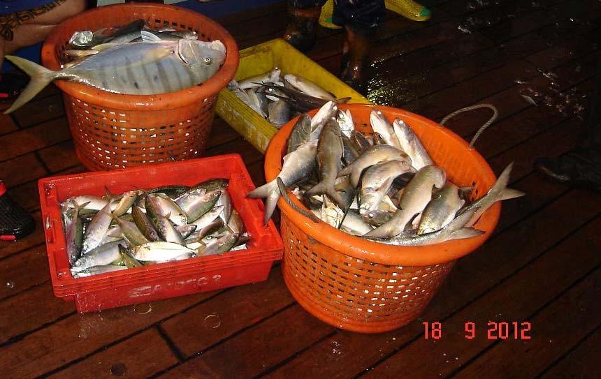
4 This new high opening trawl were operated four haul to adjust trawling technique. Trawling area are near to Phai island where depth about meter. This trial suggested that it able to catch pelagic fish. Highest catch rate was 94 kg/hour. Majority of catch are pelagic fish. Following is note for future operation and improvement of high opening trawl. The trawl body of high opening trawl is lighter than bottom trawl, therefore M.V. SEAFDEC 2 able to trawl at faster speed to maximum at 5 knots. Trawl trial by M.V.SEAFDEC 2 found that maximum trawl height is 22 meter with ship speed at 3.5 knots while the faster speed (4.5 knots) reduced trawl height to 8 12 meter. Head rope should be improved to avoided entangle with trawl wing. Number of float should be added as well in order to increase the trawl height. Figure 1 Map of working area (pink square) 3

5 Figure 2 Underwater VDO camera performance testing 4

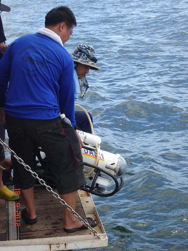
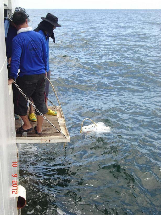
6 Figure 3 ROV performance testing 5


7 Figure 4 Portable Echo Sounder performance testing Ship For fixing rope 24 Figure 5 Suggested Echo sounder transducer mouthing unit 6


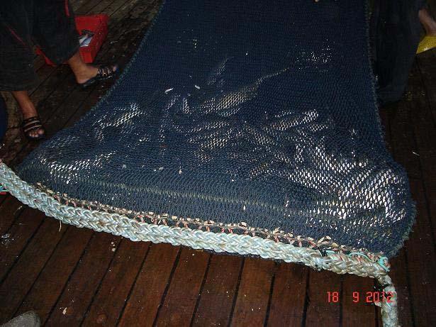
8 Figure 6 High Opening Trawl performance testing 7
9 Activities time table Date/time Activities 17 September :00 10:00 10:00 11:00 Lecture on Bottom topography survey by. Dr. Pachoenchoke Lecture on Mapping the sea floor by Dr. Pachoenchoke 11:00 14:00 Equipment preparation 14:00 16:00 M.V.SEAFDEC 2 leave for Phai island 17:00 19:00 Underwater VDO camera performance testing 18 September :00 08:30 High opening trawl performance testing 08:30 10:00 Portable echo sounder no.1 performance testing 10:00 11:00 High opening trawl #1 11:00 13:00 ROV performance testing 13:00 15:00 Underwater VDO camera performance testing 15:00 17:00 High opening trawl #2 19:00 19:30 Discussion for testing result 19 September :00 07:30 High opening trawl #3 07:30 10:00 High opening trawl #4 10:00 11:00 Packing all equipments 11:00 15:00 Leave for SEAFDEC/TD 16:00 Arrived SEAFDEC/TD 8
10 9 ANNEX I


11 10


12 11


13 12


14 13

15 14 ANNEX II


16 15


17 16


18 17

19 18
Survey Report on Demersal Fishery Resources Living in Un trawlable Area in Rakhine Fishing Ground of Myanmar using Bottom Vertical Longline
 Survey Report on Demersal Fishery Resources Living in Un trawlable Area in Rakhine Fishing Ground of Myanmar using Bottom Vertical Longline 23 30 January 2009 Department of Fisheries, Myanmar Southeast
Isaacs Kidd Mid water Trawl
 2007 Standard Operating Procedures of Isaacs Kidd Mid water Trawl NAKARET YASOOK APINANT TARADOL TAWEESAK TIMKRUB NARONG REUNGSIVAKUL SOMBOON SIRIRAKSOPHON SOUTHEAST ASIAN FISHERIES DEVELOPMENT CENTER
Technical Report Some Technical Aspects on Midwater Trawl Operations Lesson learnt from the Operation of M.V.SEAFDEC2 around Viet Nam Waters
 Technical Report Some Technical Aspects on Midwater Trawl Operations Lesson learnt from the Operation of M.V.SEAFDEC2 around Viet Nam Waters Isara Chanrachkij, Tossaporn Sukibindha, Sayan Promjinda, and
PROJECT DOCUMENT ACHIEVEMENTS FOR YEAR 2018 AND PROPOSED ACTIVITY FOR YEAR 2019
 Forty-first Meeting of the Program Committee Southeast Asian Fisheries Development Center Bayview Hotel, Langkawi, Malaysia 5-7 November 2018 WP03.1.1.9 PROJECT DOCUMENT ACHIEVEMENTS FOR YEAR 2018 AND
Expert Meeting on Deep-Sea Fishing and Its Impact to Ecosystem 31 August - 2 September 2010, Jasmine Hotel, Bangkok, Thailand
 Expert Meeting on Deep-Sea Fishing and Its Impact to Ecosystem 31 August - 2 September 2010, Jasmine Hotel, Bangkok, Thailand BRUNEI DARUSSALAM LIST OF PARTICIPANT Ms. Desimawati Haji Metali Fisheries
Assessing the Status of Tuna Resources in Sulu and Sulawesi Seas through Collaborative Research Survey
 Assessing the Status of Tuna Resources in Sulu and Sulawesi Seas through Collaborative Research Survey Worawit Wanchana, Isara Chanrachkij, Sayan Promjinda, Siriporn Pangsorn, and Virgilia T. Sulit Covering
Temperature, Salinity, Dissolved Oxygen and Water Masses of Vietnamese Waters
 Southeast Asian Fisheries Development Center Temperature, Salinity, Dissolved Oxygen and Water Masses of Vietnamese Waters Penjan Rojana-anawat, Siriporn Pradit, Natinee Sukramongkol and Somboon Siriraksophon
FINAL REPORT DERELICT FISHING GEAR IDENTIFICATION AND REMOVAL PROJECT PORT SUSAN
 1900 W. NICKERSON, STE. 207 SEATTLE, WASHINGTON 98119-1650, U.S.A. TELEPHONE: (206) 285-3480 TELEFAX: (206) 283-8263 E-Mail : jjune@nrccorp.com (corporate) FINAL REPORT DERELICT FISHING GEAR IDENTIFICATION
Visual Observation on Fishes Schooling and Fishing Activities in the South China Sea, Area III : Western Philippines
 Proceedings of the SEAFDEC Seminar on Fishery Resources in the South China Sea, Area III: Western Philippines Visual Observation on Fishes Schooling and Fishing Activities in the South China Sea, Area
Fish Conservation and Management
 Fish Conservation and Management CONS 486 Fisheries Exploitation Chapters 4 and 5 Ross Fisheries Exploitation Fisheries sectors (i.e., user groups) Fisheries harvest methods Major theme: Linking science
The MEDUSA Deep Sea and FUSION AUVs:
 1 The MEDUSA Deep Sea and FUSION AUVs: When Research and business get together EMRA 2017, Girona, Spain 15 May 2017 Bruno Cardeira/IST Deep Ocean Exploration -Why the effort? Portugal Exclusive Economic
REGIONAL FISHING VESSELS RECORD (RFVR): A TOOL TO COMBAT THE IUU FISHING IN SOUTHEAST ASIAN REGION. Executive Summary
: A TOOL TO COMBAT THE IUU FISHING IN SOUTHEAST ASIAN REGION. Executive Summary") The Eighteenth Meeting of Fisheries Consultative Group of the ASEAN-SEAFDEC Strategic Partnership (FCG/ASSP) Dusit Thani Hotel, Manila, the Philippines 26-27 November 2015 WP06.2.1 REGIONAL FISHING VESSELS
The Eighteenth Meeting of Fisheries Consultative Group of the ASEAN-SEAFDEC Strategic Partnership (FCG/ASSP) Dusit Thani Hotel, Manila, the Philippines 26-27 November 2015 WP06.2.1 REGIONAL FISHING VESSELS
BACKGROUND TO STUDY CASE
 BACKGROUND TO STUDY CASE German Aerospace Center (DLR) is using Andøya Rocket Range for a sounding rocket campaign. On 27th October 2005 a 300 kg payload (SHEFEX) was launched Due do a technical problems
Fish Conservation and Management
 Fish Conservation and Management CONS 486 Fisheries Exploitation Chapters 4 and 5 Ross Fisheries Exploitation Fisheries sectors (i.e., user groups) Fisheries harvest methods Major theme: Linking science
Sustainable harvest of marine resources
 Sustainable harvest of marine resources by Senior scientist Aud Vold, Fish Capture Group The Ny-Ålesund Symposium Planet Ocean 19-21 Sept 2016 The Center for Research based Innovation in Sustainable fish
Protection for Vessels Engaged in Servicing Submarine Cables
 Protection for Vessels Engaged in Servicing Submarine Cables Proposed Amendments to COLREGS Brief to Navigation Safety Advisory Council November 28, 2012 Tampa, FL Dr. Ronald J. Rapp TE SubCom and Representing
Admiralty Inlet Pilot Tidal Project FERC No Appendix C. Derelict Gear Monitoring Plan
 Appendix C Derelict Gear Monitoring Plan ADMIRALTY INLET PILOT TIDAL PROJECT FERC PROJECT NO. 12690 DERELICT GEAR MONITORING PLAN (submitted with the Final Application for a New Pilot Project License)
Using AUVs in Under-Ice Scientific Missions
 Using AUVs in Under-Ice Scientific Missions James Ferguson, International Submarine Engineering Ltd. Presented at Arctic Change 08 11 Decenber 2008- Quebec City, Canada 1/16 ISE s s Experience in Arctic
Draft REPORT OF THE EXPERT MEETING ON DEEP-SEA FISHING AND ITS IMPACT TO ECOSYSTEM 31 August - 2 September 2010 Bangkok, Thailand
 Draft REPORT OF THE EXPERT MEETING ON DEEP-SEA FISHING AND ITS IMPACT TO ECOSYSTEM 31 August - 2 September 2010 Bangkok, Thailand 1. The Expert Meeting on Deep-sea Fishing and Its Impact to Ecosystem was
An Overview of Methods for Estimating Absolute Abundance of Red Snapper in the Gulf of Mexico
 An Overview of Methods for Estimating Absolute Abundance of Red Snapper in the Gulf of Mexico JM Drymon 1, Greg Stunz 2 1. Mississippi State University, Coastal Research and Extension Center 2. Harte Research
Design and Planning Considerations For a Seabed Survey
 Design and Planning Considerations For a Seabed Survey Vera Quinlan Hydrographer & Data Processor Seabed Survey Overview Survey Platform - What boat do I use? Survey Area / depth of water / objective &
Institute of Marine Research
 Institute of Marine Research CRUISE REPORT NO. ** R/V G.O. Sars Cruise No. 2005108 9 th June 24 th June 2005 Coral survey off Northern Norway Principal Scientist J. H. Fosså 2005 Benthic Habitat Research
Underwater Robots Jenny Gabel
 Underwater Robots Jenny Gabel 06.01.2014 Table of Contens Introduction Challenges of Underwater Exploration Remotely Operated Vehicles Autonomous Underwater Vehilces Future Perspectives References 2 Introduction
Evolution of Deepwater Coral Protection in the Southeast U.S
 Evolution of Deepwater Coral Protection in the Southeast U.S Tina Udouj, Florida Fish and Wildlife Conservation Commission Roger Pugliese, South Atlantic Fishery Management Council Overview Deepwater Corals
S u p e r G N O M P R O The new line of GNOM ROVs for professional uses. The wide range of the additional equipment can be installed.
 S u p e r G N O M P R O The new line of GNOM ROVs for professional uses. The wide range of the additional equipment can be installed. - Operating depth 300 m (500 m optional) - Cruising speed up to 4 knots
Tools of Oceanography Ocean Currents. Drift Bottles and Dyes: measures speed and direction of ocean currents.
 Tools of Oceanography Ocean Currents Drift Bottles and Dyes: measures speed and direction of ocean currents. Ekman Current Meters: measures speed and direction of currents in deep water. Ocean Water Sampling
ROV Development ROV Function. ROV Crew Navigation IRATECH SUB SYSTEMS 2010
 IR AT EC H SU B SY ST EM S 20 10 Remotely Operated Vehicle ROV INTRODUCTORY 2008 2008 1 KEY POINTS ROV Introductory ROV Development ROV Function Types of ROV ROV Crew Navigation ROV Components 2 ROV Development
NT09-21 Cruise Report SURUGA-BAY Cable Laying Experiment / VBCS Function Test
 NT09-21 Cruise Report SURUGA-BAY Cable Laying Experiment / VBCS Function Test December 2009 Table of Contents 1. Overview 2. Schedule 3. Dive Summary 4. Concluding Remarks 1. Overview A unique development
I. Monitoring and Adaptive Management Approach. Potential Effects, Monitoring Studies & Mitigation
 I. Monitoring and Adaptive Management Approach Define the problem or management objective. Determine potential effects of the project on indicator species. Emphasis on examining potentially negative, rather
Natsushima Cruise Report NT Sea trial of Autonomous Underwater Vehicle. Yumeiruka around Omuro-dashi. Sagami Bay, Suruga Bay and Omuro-dashi
 Natsushima Cruise Report NT15-11 Sea trial of Autonomous Underwater Vehicle Yumeiruka around Omuro-dashi Sagami Bay, Suruga Bay and Omuro-dashi July 5, 2015 July 10, 2015 Japan Agency for Marine-Earth
Scanning Sonar and ROV Operations. For Underwater SAR Imaging Applications
 Scanning Sonar and ROV Operations For Underwater SAR Imaging Applications This training module provides information specific to integrating scanning sonar onto an ROV platform and fundamentals in using
Cruise Report Cruise no. 06NG-06TG. Exploratory investigations on Norwegian spring-spawning herring in the Norwegian Sea November 2006
 Cruise Report Cruise no. 06NG-06TG Exploratory investigations on Norwegian spring-spawning herring in the Norwegian Sea 17 24 November 2006 M/S Norðborg M/S Tróndur í Gøtu Jan Arge Jacobsen Mourits Mohr
The Dalles Dam Powerhouse Trash Rack ROV Inspection Report
 The Dalles Dam Powerhouse Trash Rack ROV Inspection Report Report date: 8/21/13; Inspection conducted for: ROV Inspection by: Inspection location: The Dalles Dam, POC Robert Cordie; NWP Office of Dive/
Delegation of Australia
 SC-03-06.3.2 (11) 3 rd Meeting of the Southern Indian Ocean Fisheries Agreement (SIOFA) Scientific Committee 20-24 March 2017, Saint Denis, La Reunion Proposal for designation of the RUSKY KNOLL fishery
Best Practice Guidance for Assessing the Financial Performance of Fishing Gear: Industry-led gear trials
 Best Practice Guidance for Assessing the Financial Performance of Fishing Gear: Industry-led gear trials Prepared for The UK Fisheries Economic Network (UKFEN) by Seafish Introduction and Background Reducing
Location: Barkley Canyon Date: September 9, 2013 Constraints: none
 Page 1 of 11 DIVE PLAN R1650 Location: Barkley Canyon Date: September 9, 2013 Constraints: none Objectives Deploy POD 1 autonomous CTD Survey POD 3 for sediment enrichment sites; deposit cages; collect
R/V Natsushima Cruise Report NT15-21
 R/V Natsushima Cruise Report NT15-21 Survery for SIP cable observation system Off Izu-Oshima Dec.8,2015-Dec.16,2015 Japan Agency for Marine-Earth Science and Technology (JAMSTEC) Contents 1. Cruise Information
Vieques Underwater Demonstration Project
 Vieques Underwater Demonstration Project NOAA Office of Response and Restoration National Ocean Service 2006-2007 2007 University of New Hampshire Joint Hydrographic Center 2006 Science Application International
Panel Discussion on unmanned Hydrography
 Panel Discussion on unmanned Hydrography Overview Why bother General Types Autonomous Underwater Vehicle (AUV) Remotely Operated Vehicle (ROV) Unmanned Surface Vessels (USV) TerraSond s Experiences AUV
HOW TO BEST USE YOUR ELECTRONICS: CHARTING, SONAR, AND IMAGING. By: Captain Tom Blackburn
 HOW TO BEST USE YOUR ELECTRONICS: CHARTING, SONAR, AND IMAGING By: Captain Tom Blackburn Topics I. INTRODUCTION II. CHARTING A TREMENDOUS FISH FINDING TOOL III. CHARTING - SIGNIFICANT CHARTING AND NAVIGATIONAL
Geostrophic and Tidal Currents in the South China Sea, Area III: West Philippines
 Southeast Asian Fisheries Development Center Geostrophic and Tidal Currents in the South China Sea, Area III: West Philippines Anond Snidvongs Department od Marine Science, Chulalongkorn University, Bangkok
Rope-less Fishing in Practice Today Ropeless Workshop Feb Woods Hole Oceanographic Institution. Michael Moore
 Rope-less Fishing in Practice Today Ropeless Workshop Feb 1 2018 Woods Hole Oceanographic Institution Michael Moore mmoore@whoi.edu Background To haul without endlines is a fundamental change in how most
Rockhopper/Chain Sweep Relative Catch Efficiency Analysis
 Rockhopper/Chain Sweep Relative Catch Efficiency Analysis Northeast Fisheries Science Center Michael Martin Ecosystems Surveys Branch Northeast Fisheries Science Center Woods Hole, MA 5/31/2016 Study Motivation:
Rule 26 - Fishing vessels
 (a) A vessel engaged in fishing, whether underway or at anchor, shall exhibit only the lights and shapes prescribed in this Rule. (b) A vessel when engaged in trawling, by which is meant the dragging through
NEW SURVEY MOTOR LAUNCHES FOR THE ROYAL AUSTRALIAN NAVY
 International Hydrographic Review, Monaco, LXVI(l), January 1989 NEW SURVEY MOTOR LAUNCHES FOR THE ROYAL AUSTRALIAN NAVY by Commander John LEECH, RAN (*) INTRODUCTION By any standards the task facing the
Aim. Survey Methodology
 The fish that smells of cucumber: conservation of smelt Osmerus eperlanus in the Thames Estuary Interim Report on results of 2015 survey work Joanna Barker Project Manager, Europe Conservation Programme
Utilizing Vessel Based Mobile LiDAR & Bathymetry Survey Techniques for Survey of Four Southern California Breakwaters
 Utilizing Vessel Based Mobile LiDAR & Bathymetry Survey Techniques for Survey of Four Southern California Breakwaters Western Dredging Association: Pacific Chapter September 2012 Insert: Pipe Location
KAIYO CRUISE REPORT. KY15-16 Leg1
 KAIYO CRUISE REPORT KY15-16 Leg1 Construction of DONET2 Off Kii Channel Oct.16,2015-Nov.6,2015 Japan Agency for Marine-Earth Science and Technology (JAMSTEC) 1 Contents 1. Cruise Information -----------------------------------------
14/10/2013' Bathymetric Survey. egm502 seafloor mapping
 egm502 seafloor mapping lecture 10 single-beam echo-sounders Bathymetric Survey Bathymetry is the measurement of water depths - bathymetry is the underwater equivalent of terrestrial topography. A transect
Update on Canadian Research Vessels Ship Procurement Projects
 Update on Canadian Research Vessels Ship Procurement Projects 28 th International Research Ship Operators Meeting (IRSO) La Jolla, California October 2012 Jennifer Vollrath 1 Outline National Ship Building
IFREMER, Department of Underwater Systems, Toulon, France. L u c i e Somaglino, P a t r i c k J a u s s a u d, R o main P i a s co, E w e n Raugel
 F i r s t s e a t r i a l s w i t h E M 2 0 4 0 m u l t i b e a m s o u n d e r i n n o v a t i v e i n t e g r a t i o n o n H y b r i d R O V A r i a n e IFREMER, Department of Underwater Systems, Toulon,
REPORT OF THE TRAINING WORKSHOP ON IDENTIFICATION OF DEEP-SEA BENTHIC MACROINVERTEBRATE VULNERABLE TO FISHING GEAR
 SEAFDEC/TD Workshop Report 2011 REPORT OF THE TRAINING WORKSHOP ON IDENTIFICATION OF DEEP-SEA BENTHIC MACROINVERTEBRATE VULNERABLE TO FISHING GEAR Samutprakarn, Thailand, 11-15 July 2011 R TD/RP/149 Preparation
Engineering Design Challenge. Mapping the Ocean Floor
 Engineering Design Challenge Project Title: Project Source: Project Submitter: Mapping the Ocean Floor NOAA, http://tinyurl.com/boydlek STEM Improvement Lesson Development Team Grade Level/Subject: Math,
/ Advice May 2011
 1.5.1.3/1.5.4.1 Advice May 2011 ECOREGION SUBJECT General advice Update of cold-water coral and sponge maps and the information underpinning such maps on Vulnerable Marine Habitats (including Hatton and
Report on Bycatch of Tuna Longline Fishing Operation Eastern Indian Ocean by SEAFDEC Research Vessels Year
 Report on Bycatch of Tuna Longline Fishing Operation Eastern Indian Ocean by SEAFDEC Research Vessels Year 2005-2011 Sayan promjinda, Isara Chanrachkij Southeast Asian Fisheries Development Center 1) Abstract
***This summary does not include shad and herring net requirements.***
 South Carolina Department of Natural Resources Marine Resources Division Summary of Seine and Gill Net Laws (Saltwater) 2013-2014 This document should be kept on board all vessels using seines or gill
Co-Principal Investigators Stephen C. Jewett, Ph.D. Paul C. Rusanowski, Ph.D.
 PROGRESS REPORT FACTORS AFFECTING NEARSHORE SURVIVAL AND PRODUCTION OF JUVENILE SOCKEYE SALMON FROM KVICHAK BAY Phase I: Important habitat, migration routes and food resources CoPrincipal Investigators
PROMOTION OF THE CONSERVATION AND MANAGEMENT OF TROPICAL ANGUILLID EEL RESOURCES AND PROMOTION OF SUSTAINABLE AQUACULTURE SEAFDEC-IFRDMD
 Fiftieth Meeting of the Council Southeast Asian Fisheries Development Center Sokha Siem Reap Resort & Convention Center Hotel Siem Reap, Cambodia, 26-30 March 2018 WP05.2.2 PROMOTION OF THE CONSERVATION
Yokosuka Cruise Report YK11-02
 Yokosuka Cruise Report YK11-02 Sea Trial of The HETL Fuel Cell System for Underwater Platform JAMSTEC ~ Sagami-Bay ~ JAMSTEC March 6, 2011 ~ March 9, 2011 Japan Agency for Marine-Earth Science and Technology
Update on recent modifications of fishing gear and fishing procedures to reduce bycatch of sea turtles in longline fishery
 TC:STCF/2004/DMA.2 Update on recent modifications of fishing gear and fishing procedures to reduce bycatch of sea turtles in longline fishery Thomas Moth-Poulsen FAO Fishery Industry Officer (Fish Technology)
Scottish Hydro Electric Power Distribution Operation, Inspection, Maintenance and Decommissioning Strategy Bute Cumbrae Cable Replacement
 SHEPD Section ID 154 Scottish Hydro Electric Power Distribution Operation, Inspection, Maintenance and Decommissioning Strategy Bute Cumbrae Cable Replacement Contents Definitions and Abbreviations...
Regional Cooperation for Sustainable Utilization of Neritic Tunas in Southeast Asia. SEAFDEC Secretariat
 Forty-sixth Meeting of the Council Southeast Asian Fisheries Development Center The Orchard Hotel, Singapore 1-4 April 2014 WP05.2 Regional Cooperation for Sustainable Utilization of Neritic Tunas in Southeast
Using Sonar for Navigation
 Using Sonar for Navigation By Steve Dashew We spend a lot of time cruising in remote areas, where charts tend to be out-of-date or nonexistent. For years we've been thinking about using sonar for navigation
CMM Conservation and Management Measure for the Management of Bottom Fishing in the SPRFMO Convention Area
 CMM 03-2018 1 Conservation and Management Measure for the Management of Bottom Fishing in the SPRFMO Convention Area The Commission of the South Pacific Regional Fisheries Management Organisation; RECOGNISING
R.P. Prabath K. JAYASINGHE National Aquatic Resources Research and Development Agency (NARA) Colombo 15 SRI LANKA
 Colombo 15 SRI LANKA") Experience and the special requirements of Sri Lanka in addressing the impacts of bottom fisheries on vulnerable marine ecosystems and the long-term sustainability of deep-sea fish stocks in particular
Experience and the special requirements of Sri Lanka in addressing the impacts of bottom fisheries on vulnerable marine ecosystems and the long-term sustainability of deep-sea fish stocks in particular
API Study on Detection and Recovery of Sunken Oil. API Study Objectives
 API Study on Detection and Recovery of Sunken Oil Jacqueline Michel, Research Planning, Inc. Mark Ploen, QualiTech Jim Elliott, T&T Marine Salvage, Inc. William Key API Study Objectives 1. ID current best
Imaging Fall Chinook Salmon Redds in the Columbia River with a Dual-Frequency Identification Sonar
 North American Journal of Fisheries Management 24:1421 1426, 2004 Copyright by the American Fisheries Society 2004 Imaging Fall Chinook Salmon Redds in the Columbia River with a Dual-Frequency Identification
Autonomous Underwater Vehicles Explorer Class
 Autonomous Underwater Vehicles Explorer Class Neil Bose Professor of Maritime Hydrodynamics Manager, Australian Maritime Hydrodynamics Research Centre AMC National Centre for Maritime Engineering and Hydrodynamics
UNDERWATER SCIENCE. Multibeam Systems TECHNOLOGY FOR SUSTAINABLE FISHERIES
 UNDERWATER SCIENCE Multibeam Systems TECHNOLOGY FOR SUSTAINABLE FISHERIES SIMRAD ME70 SCIENTIFIC MULTIBEAM ECHO SOUNDER A scientific multibeam echo sounder can be seen as many EK sounders spread out in
2016 West Coast Entanglement Summary
 March 2017 2016 West Coast Entanglement Summary Overview of Entanglement Data west coast region MMHSRP Permit #18786 In 2016, 71 separate cases of entangled whales were reported off the coasts of Washington,
Advantages of Using Combined Bathymetry and Side Scan Data in Survey Processing T.M. Hiller, L.N. Brisson
 Advantages of Using Combined Bathymetry and Side Scan Data in Survey Processing T.M. Hiller, L.N. Brisson EdgeTech, West WareHam MA, USA EdgeTech 6205 Combined Bathymetric and Side Scan Sonar EdgeTech
Characterization of the Sole Fishery in The Gambia. Gambia-Senegal Sustainable Fisheries Program (Ba Nafaa)
") Characterization of the Sole Fishery in The Gambia Gambia-Senegal Sustainable Fisheries Program (Ba Nafaa) January 2011 This publication is available electronically on the Coastal Resources Center s website
Characterization of the Sole Fishery in The Gambia Gambia-Senegal Sustainable Fisheries Program (Ba Nafaa) January 2011 This publication is available electronically on the Coastal Resources Center s website
Feasibility Study: Remote Sensing of Lost Snow Crab Pots in Newfoundland and Labrador
 Feasibility Study: Remote Sensing of Lost Snow Crab Pots in Newfoundland and Labrador Fisheries and Marine institute of Memorial University of Newfoundland Centre for Sustainable Aquatic Resources, Centre
Marine Towed Array Surveys of Ostrich Bay, Lake Erie and Puerto Rico.
 Marine Towed Array Surveys of Ostrich Bay, Lake Erie and Puerto Rico. Chet Bassani, Nagi Khadr, Chris Gibson and Jim McDonald Advanced Sensors and Analysis Div., SAIC Cary, NC Marine Towed Array (MTA)
Recommended operating guidelines (ROG) for sidescan Sidescan sonar ROG in wrapper.doc English Number of pages: 9 Summary:
 for sidescan Sidescan sonar ROG in wrapper.doc English Number of pages: 9 Summary:") Title: Author(s): Document owner: Recommended operating guidelines (ROG) for sidescan sonar Dave Long (BGS) Dave Long (BGS) Reviewed by: Janine Guinan (MI) 07/09/07 Workgroup: MESH action: 2.1 Version:
Title: Author(s): Document owner: Recommended operating guidelines (ROG) for sidescan sonar Dave Long (BGS) Dave Long (BGS) Reviewed by: Janine Guinan (MI) 07/09/07 Workgroup: MESH action: 2.1 Version:
Accident Report. San Constanzo Flooding approximately 35 miles east of Gisborne on 18 January 2004
 Accident Report San Constanzo Flooding approximately 35 miles east of Gisborne on 18 January 2004 SUMMARY Leaking seams in the vessel s wooden hull, allowed water to enter the vessel and flood the forward
RULES PUBLICATION NO. 52/P UNDERWATER INSPECTION OF MOBILE OFFSHORE DRILLING UNITS IN LIEU OF DRYDOCKING
 RULES PUBLICATION NO. 52/P UNDERWATER INSPECTION OF MOBILE OFFSHORE DRILLING UNITS IN LIEU OF DRYDOCKING 2001 Publications P (Additional Rule Requirements) issued by Polski Rejestr Statków complete or
New information regarding the impact of fisheries on other components of the ecosystem
 ICES Advice North Atlantic Ecoregion Published 20 June 2017 DOI: 10.17895/ices.pub.3059 New information regarding the impact of fisheries on other components of the ecosystem Advice summary ICES has received
Mitsui Engineering & Shipbuilding Co., LTD. Kenji NAGAHASHI
 Mitsui Engineering & Shipbuilding Co., LTD. Kenji NAGAHASHI kenji_nagahashi@mes.co.jp Contents 1. Underwater Robots produced by MES 2. Future Concept 2 Image of Underwater Works Research Vessel Communication
Southeast Asian Fisheries Development Center
 Southeast Asian Fisheries Development Center Responsible Fishing Technologies and Sustainable Coastal Fisheries Management in Southeast Asia Siri Ekmaharaj Established in December 1967 for the purpose
JIMAR PFRP ANNUAL REPORT FOR FY 2006
 JIMAR PFRP ANNUAL REPORT FOR FY 2006 P.I./Sponsor Name: Michael P. Seki and Jeffrey J. Polovina Project Proposal Title: Oceanographic Characterization of the American Samoa Longline Fishing Grounds for
Essential Fish Habitat OCNMS Advisory Council July 13, 2013
 Essential Fish Habitat OCNMS Advisory Council July 13, 2013 John Stadler Habitat Conservation Division NMFS Northwest Region Essential Fish Habitat (EFH) What is it, where did it come from, and what does
Life History Study of the Alligator Gar in the Ouachita River, Arkansas
 Life History Study of the Alligator Gar in the Ouachita River, Arkansas Summary: Current information indicates that a breeding population of alligator gar may inhabit the lower Ouachita River in Arkansas.
Trawl Fishery Management Myanmar
 APFIC Regional Expert Workshop on Topical Trawl Fishery Management 30 September 4 October 2013, Phuket, Thailand Trawl Fishery Management Myanmar Khin Maung Aye & Win Ko Ko Myanmar Marine Fishery a. In-shore
Marine Mammal Acoustic Tracking from Adapting HARP Technologies
 DISTRIBUTION STATEMENT A: Approved for public release; distribution is unlimited. Marine Mammal Acoustic Tracking from Adapting HARP Technologies Sean M. Wiggins and John A. Hildebrand Marine Physical
Environmental Threats from Wrecks: The Point of View of the Environmental Authorities
 Environmental Threats from Wrecks: The Point of View of the Environmental Authorities Syke-BALEX Seminar on Wrecks as Environmental Risks: The Legal Framework Jorma Rytkönen, Finnish Environment Institute
Understanding shelf-break habitat for sustainable management of fisheries with spatial overlap
 Understanding shelf-break habitat for sustainable management of fisheries with spatial overlap Alan Williams Caleb Gardner Franziska Althaus Bruce Barker David Mills Final Report to the Fisheries Research
PISCATUS 3D OVERVIEW PISCATUS 3D MODES. Piscatus 3D will increase your efficiency and reduce your costs
 More Fish Less Time Piscatus 3D delivers a real time 3D view of the ocean floor anywhere in the world, helping you to make the best decisions to catch more fish faster. PISCATUS 3D OVERVIEW Piscatus 3D
History/Explorers/Expeditions/Technology Webquest!
 Name Block History/Explorers/Expeditions/Technology Webquest! http://www.divediscover.whoi.edu/history-ocean/21st.html Click on: History of Oceanography (on the left side of the page) 1. Oceanography may
Fisheries of the Caribbean, Gulf of Mexico, and South Atlantic; Reef Fish Fishery of Puerto Rico and the U.S. Virgin Islands;
 This document is scheduled to be published in the Federal Register on 06/11/2018 and available online at https://federalregister.gov/d/2018-12420, and on FDsys.gov BILLING CODE: 3510-22-P DEPARTMENT OF
SMOOTH HAMMERHEAD SHARK (HHS)
") SMOOTH HAMMERHEAD SHARK (HHS) (Sphyrna zygaena) HHS1 1. FISHERY SUMMARY Smooth hammerhead sharks (Sphyrna zygaena) are not currently managed under the QMS. No assigned fishing allowances exist. However,
SMOOTH HAMMERHEAD SHARK (HHS) (Sphyrna zygaena) HHS1 1. FISHERY SUMMARY Smooth hammerhead sharks (Sphyrna zygaena) are not currently managed under the QMS. No assigned fishing allowances exist. However,
Figure 1: Level Pitch Positive Pitch Angle Negative Pitch Angle. Trim: The rotation of a vehicle from side to side. See Figure 2.
 Buoyancy, Stability, and Ballast 2 Cornerstone Electronics Technology and Robotics III (Notes primarily from Underwater Robotics Science Design and Fabrication, an excellent book for the design, fabrication,
WMB-160F Multi-beam Fishing System
 WMB-160F Multi-beam Fishing System Take away the guess work and see what s REALLY below your boat! Seven Systems in One 2 WMB-160F WMB-160F Screen Shots The WMB-160F is a multi-beam sonar that has been
MISSION PLANNING AND DATA ACQUISITION SOFTWARE
 MISSION PLANNING AND DATA ACQUISITION SOFTWARE INTENTIONALLY BLANK Introduction to Divelog Shark Marine s Divelog software was created to integrate data collected from an array of sensors, real-time with
Marine pollution originating from purse seine and longline fishing vessel operations in the Western and Central Pacific Ocean,
 Marine pollution originating from purse seine and longline fishing vessel operations in the Western and Central Pacific Ocean, 2003-2015 Source: Olive Ridley Project Source: Rizkiyanto, 2011 Kelsey Richardson
Preliminary Survey Notification and Information for Fisheries Interests.
 1) Viking Link Project The Viking Link project is a proposal to build a high voltage direct current (HVDC) electricity interconnector between the Lincolnshire Coast in the UK and Southern Jutland in Denmark
The TRV series has sufficient thrust to allow operations in currents up to 3 knots and down to depths of 3,300. Wolfgang Burnside
 The TRV series has sufficient thrust to allow operations in currents up to 3 knots and down to depths of 3,300 Wolfgang Burnside TRV-005 Series: Standard Features and Benefits Frame The TRV 005 Series
Unit 1 Lesson 2: Reef Surveys and Deep Worker. When Coral Reefs Get in the Way...
 Unit 1 Lesson 2: Reef Surveys and Deep Worker Lesson Objectives: Upon completion of this unit students should gain knowledge and understanding of: factors that cause physical damage to coral reefs the
Baltic Marine Environment Protection Commission Group on Ecosystem-based Sustainable Fisheries Warsaw, Poland, April 2015
 Baltic Marine Environment Protection Commission Group on Ecosystem-based Sustainable Fisheries Warsaw, Poland, 15-16 April 2015 Document title Draft HELCOM VMS data request to ICES Code 4-4 Category CMNT
Development of 7,000m Class ROV KAIKO7000
 Development of 7,000m Class ROV KAIKO7000 H. Sezoko*, T. Murashima*, H. Nakajyoh*, H. Yoshida*, N. Yamauchi** * Research Support Department (RSD), Marine Technology Center (MARITEC) Japan Agency for Marine-Earth