A PHYSICAL AND BIOLOGICAL SURVEY OF THE MID-REACH MITIGATION REEF SET NUMBER 1
|
|
|
- Marilynn Bridges
- 5 years ago
- Views:
Transcription
1 A PHYSICAL AND BIOLOGICAL SURVEY OF THE MID-REACH MITIGATION REEF SET NUMBER 1 John M. Hearin, Ph.D., P.E. 1 ; Geoff Swain, Ph.D. 2 ; Robert Weaver, Ph.D., P.E. 2 ; Kelli Z. Hunsucker, Ph.D. 2 ; Caglar Erdogan 2 ; Cierra Braga 2 ; Ann Wassick Jacobs Engineering Group, Cape Canaveral, FL 2 - Department of Ocean Engineering and Marine Science, Florida Institute of Technology, Melbourne, FL INTRODUCTION The Brevard County Mid-Reach Shore Protection Project will place sand fill along 7.6- miles of Atlantic Ocean shoreline located between Patrick Air Force Base and Indialantic, Florida. The project is anticipated to impact approximately 3 acres of existing nearshore rock hardgrounds. To mitigate the anticipated impacts to the nearshore hardgrounds, the project will also include construction of artificial reef structures upon the nearshore seabed offshore of the project shoreline (Brevard County NRMO, 2018) (Olsen Associates, 2008). The mitigation reef structures will consist of articulated concrete mats with a coquina-rock surface. Each articulated reef mat will consist of approximately 18 cable-connected blocks. Each mat would be about 8-ft x 16-ft x 1-ft high and comprise about 90 lineal ft of valleys (ridges) between blocks and adjacent mats (Figure 1). Forty-two mats, in 6 rows and 7 offset columns would be placed adjacently -- along with two additional top-layer mats along the landward edge to form an overhanging ledge. This would constitute one set of 44 mats. Each set of mats would create between about 0.15 and 0.16 acres of hard-bottom structure. Each set of mats would be placed upon the sand seabed at ambient depths of between about ft and ft MLW; i.e., approximately centered along the -15 ft MLW contour, and located about 1000-ft from the mean low water shoreline (Figure 2). Between two and five sets of mats would be spaced about 50 to 60 feet apart, along the approximate -15 ft contour, to form a reef group. These reef groups would be spaced about 400 to 9000 feet apart, or more, to create the requisite total area of reef mitigation along the shoreline. The top surface of the reef mat structures will feature almost all coquina cover with 1 to 4 deep crevices between the coquina stones that emulate the surface of the existing nearshore rock. The valleys between blocks, and the overhanging ledge on the landward end of a set of units, emulate the physical relief of crevices and ledges found across the existing natural hardbottom reef. In addition to the ledge feature, 8 to 16 gaps between the ends and sides of placed reef mats are purposefully intended to would provide resting areas appropriately sized for juvenile green turtles observed to rest and forage in similarly-sized crevices on the existing Mid Reach rock resource (Brevard County NRMO, 2018) (Olsen Associates, 2008). The first set of mitigation reefs was deployed in the summer of 2017 offshore of Pelican Beach Park at latitude and longitude as shown in Figure 3. 1

2 Figure 1. Mid-Reach mitigation reef construction. (Olsen Associates, 2008) 2
3 Figure 2. Mid-Reach mitigation reef layout. (Olsen Associates, 2008) 3
 SURVEY OF REEF SET NUMER 1 A physical and biological survey of mitigation reef set number 1 was performed on August 11, 2018 by members of the Department of Ocean Engineering and")
4 Figure 3. Mid-Reach mitigation reef set number 1 location. (Google, 2018) SURVEY OF REEF SET NUMER 1 A physical and biological survey of mitigation reef set number 1 was performed on August 11, 2018 by members of the Department of Ocean Engineering and Marine Science at the Florida Institute of Technology and Jacobs Engineering. The purpose of the survey was to assess the effectiveness of the artificial reef as mitigation for the expected loss of natural reef along the Mid- Reach of Brevard County. Ocean Conditions during Survey The sea surface was calm and glassy during the survey. There was less than 1 foot of swell present. The underwater visibility varied from 1 to 3 feet at reef depth with periods of zero visibility due to turbulence. Survey Methods The survey team utilized SCUBA and snorkeling gear to perform a physical inspection of the reef. Underwater cameras were used to take photographs of the reef and any biological organisms inhabiting the reef. Two quadrants were carried by the divers, but the poor visibility rendered them useless for collecting photoquadrats. Instead very closeup photographs were taken of the predominant species noted on the reef. These photographs were analyzed by members of the Center for Corrosion and Biofouling Control at the Florida Institute of Technology to identify the organisms. 4
5 Physical Survey Results The artificial reef appeared to be intact. Some buckling between the reef segments was noted but there was no evidence of damage or missing segments. The sediment overburden on the reef varied from 0 to 3 inches. The vertical relief of the reef segments, above the sandy seabed, varied from 0 to 3 feet. The extra foot of elevation was due to the buckling between some segments which raised the top layer elevation above its design height of 2 feet. No settlement or burial of the reef segments was noted. Some scour was noted around the edges of the reef which created ledges and holes where fish could hide. Numerous crevices and holes were noted in the spaces between the reef segments which provided hiding areas for fish and other sea life. Biological Survey Results The reef was well colonized with epibiota and fishes. A list of the organisms identified via survey photographs is shown in Table 1. Some example survey photographs are shown in Figure 4. No sea turtles were noted during the survey. There were numerous colonies of sabellariid worm (worm rock) that exceeded 4 square feet of reef coverage noted during the survey. Due to the poor visibility, it was not possible to quantify the coverage of any specific organism on the reef during the survey. Organism Common Name Phragmatopoma caudata sabellariid worm, worm rock Diplosoma glandulosum colonial tunicate Portunus spinimanus Blotched Swimming Crab Echinometra lucunter lucunter Rock Boring Urchin White Colonial tunicate Red Colonial Tunicate Green Filamentous Algae Arborescent Bryozoan Black Durgon/ Black triggerfish Sheepshead Table 1. Organisms identified via survey photographs. (Humann & Deloach, 1992) 5


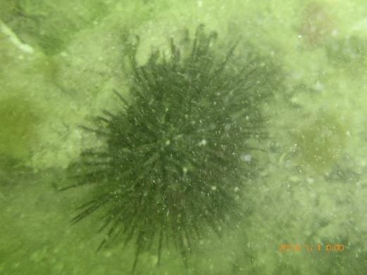


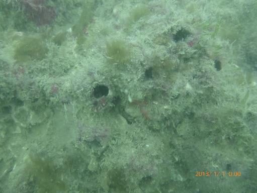
6 Sabellariid Worm Rock ColonialTunicate Blotched Swimming Crab Rock Boring Urchin Arborescent Bryozoan White Colonial Tunicate Red Colonial Tunicate Figure 4. Examples of survey photographs. Green Filamentous Algae 6
7 SURVEY OF REEF SET #1 CONCLUSIONS Artificial Reef Set #1 appeared to be in good condition one year after deployment. The reef withstood Hurricane Irma without any obvious signs of damage. The reef was well colonized with epibiota and fishes. The organisms identified via survey photographs appeared similar to the organisms identified on the natural reef during a survey performed in 2005 (Continental Shelf Associates Inc., 2005). Based on all the available data collected during this survey, the artificial reef appears to be performing its function as mitigation for the expected loss of natural reef from the Brevard County Mid-Reach Shore Protection Project. REFERENCES Brevard County NRMO. (2018). Brevard County Mid Reach Shore Protection Project. Melbourne, FL: Brevard County. Continental Shelf Associates Inc. (2005). Results of Epibiotic Surveys of Nearshore Rock Outcrops in the Mid Reach Project Area in Brevard County, Florida. Jupiter, FL: Continental Shelf Associates Inc. Google. (2018). Google Maps. Humann, P., & Deloach, N. (1992). Reef Creature Identification: Florida, Caribbean, Bahamas. 2nd Edition. Olsen Associates. (2008). Brevard County Mid-Reach Shore Protection Project. Jacksonville, FL: Olsen Associates, Inc. 7
East Central Florida Region Matt Culver, Brevard County James Gray, Indian River County Jim Oppenbourn, St. Lucie County Kathy Fitzpatrick, Martin
 James Gray, Indian River County January 14, 2015 East Central Florida Region Matt Culver, Brevard County James Gray, Indian River County Jim Oppenbourn, St. Lucie County Kathy Fitzpatrick, Martin County
Lee E. Harris, Ph.D., P.E. Assoc. Professor of Ocean Engineering. Doug Bowlus and Ashley Naimaster Ocean Engineering Graduate Students
 FLORIDA TECH OCEAN ENGINEERING PROFESSOR LEE HARRIS AND HIS GRADUATE STUDENTS ASSIST WITH POST-HURRICANE IVAN CORAL REEF RESTORATION IN THE CAYMAN ISLANDS Lee E. Harris, Ph.D., P.E. Assoc. Professor of
STATUS REPORT FOR THE SUBMERGED REEF BALL TM ARTIFICIAL REEF SUBMERGED BREAKWATER BEACH STABILIZATION PROJECT FOR THE GRAND CAYMAN MARRIOTT HOTEL
 August 23 STATUS REPORT FOR THE SUBMERGED REEF BALL TM ARTIFICIAL REEF SUBMERGED BREAKWATER BEACH STABILIZATION PROJECT FOR THE GRAND CAYMAN MARRIOTT HOTEL performed by Lee E. Harris, Ph.D., P.E. Consulting
Beach Nourishment Impact on Beach Safety and Surfing in the North Reach of Brevard County, Florida
 Beach Nourishment Impact on Beach Safety and Surfing in the North Reach of Brevard County, Florida Prepared by John Hearin, Ph.D. Coastal Engineering Vice Chairman Cocoa Beach Chapter Port Canaveral Patrick
Investigations and Recommendations for Solutions to the Beach Erosion Problems in the City of Herzliya, Israel
 Investigations and Recommendations for Solutions to the Beach Erosion Problems in the City of Herzliya, Israel Site Inspection Performed 30 April to 6 May 2007 Prepared for: City of Herzliya Office of
Mitigation Plan for Broward County Beach Erosion Control Project Broward County, Florida
 Mitigation Plan for Broward County Beach Erosion Control Project Broward County, Florida United States Army Corps of Engineers Permit # 199905545 (IP-DSG) Florida Department of Environmental Protection
Martin County s Nearshore Mitigation Reefs Year-6 Monitoring Report
 Martin County s Nearshore Mitigation Reefs Year-6 Monitoring Report by Lee E. Harris, Ph.D., P.E,. Kerry L. Dillon, and Laura Herren All photographs taken by Lee E. Harris in 2006 unless otherwise noted.
WALTON COUNTY NRDA ARTIFICIAL REEF PROGRAM
 WALTON COUNTY NRDA ARTIFICIAL REEF PROGRAM Melinda Gates Lauren Floyd Kathryn Brown Beau Suthard, PG Franky Stankiewicz Walton County - Coastal Resource Liaison APTIM - Senior Marine Biologist APTIM -
Beach Renourishment in Jacksonville
 Beach Renourishment in Jacksonville Kevin Bodge, PhD, P.E. - Olsen Associates, Inc. 1978 Oct 2004 2000 2016 2011 Oct 2016 Coastal Duval County, FL Nassau Sound Blount Island Ft. George Inlet St. Johns
Sea urchin density along a depth gradient at Rodney's Rock and Champagne Bay, Dominica
 Sea urchin density along a depth gradient at Rodney's Rock and Champagne Bay, Dominica Michele Felix Cassie Kalinec Julia Lemmon Carl Raetzsch A.J. Vale Andrew Woolley May 28 June 17, 2004 1 Abstract The
ESSENTIAL FISH HABITAT HABITAT AREAS OF PARTICULAR CONCERN (EFH-HAPC) AND CORAL HABITAT AREAS OF PARTICULAR CONCERN (C-HAPC)
 AND CORAL HABITAT AREAS OF PARTICULAR CONCERN (C-HAPC)") ESSENTIAL FISH HABITAT HABITAT AREAS OF PARTICULAR CONCERN () AND CORAL HABITAT AREAS OF PARTICULAR CONCERN (C-HAPC) Shrimp Sargassum All coastal inlets, all statedesignated habitats of particular importance
ESSENTIAL FISH HABITAT HABITAT AREAS OF PARTICULAR CONCERN () AND CORAL HABITAT AREAS OF PARTICULAR CONCERN (C-HAPC) Shrimp Sargassum All coastal inlets, all statedesignated habitats of particular importance
Changes in Beach Profile and Grain Size after Beach Renourishment
 Kevin Bodge, PE PhD Krista Egan, EI olsen associates, inc. and Mike McGarry Brevard County Natural Resources Mgt. Dept. Changes in Beach Profile and Grain Size after Beach Renourishment February 2018 Beach
ARTIFICIAL REEF CONSTRUCTION: AN ENGINEERED APPROACH. Timothy K. Blankenship, P.E. R. Harvey Sasso, P.E.
 ARTIFICIAL REEF CONSTRUCTION: AN ENGINEERED APPROACH Timothy K. Blankenship, P.E. R. Harvey Sasso, P.E. Coastal Systems International, Inc. 464 South Dixie Highway Coral Gables, Florida 33146 Stephen Higgins
I. Monitoring and Adaptive Management Approach. Potential Effects, Monitoring Studies & Mitigation
 I. Monitoring and Adaptive Management Approach Define the problem or management objective. Determine potential effects of the project on indicator species. Emphasis on examining potentially negative, rather
CHAPTER 179. Performance of a Submerged Breakwater for Shore Protection
 CHAPTER 179 Abstract Performance of a Submerged Breakwater for Shore Protection Albert E. Browder',A. Member, ASCE; Robert G. Dean 2, Member, ASCE; and Renjie Chen 3 A summary is presented of the results
OECS Regional Engineering Workshop September 29 October 3, 2014
 B E A C H E S. M A R I N A S. D E S I G N. C O N S T R U C T I O N. OECS Regional Engineering Workshop September 29 October 3, 2014 Coastal Erosion and Sea Defense: Introduction to Coastal Dynamics David
Frequency of Percnon gibbesi in relation to. Diadema antillarum at Rodney s Rock
 Frequency of Percnon gibbesi in relation to Diadema antillarum at Rodney s Rock By: Rickey Wallace Study Abroad Dominica Summer 2007 Texas A&M University Dr. Bob Wharton Dr. Jim Woolley Abstract The nimble
Lecture Benthic Ecology
 Lecture Benthic Ecology Benthos Unlike the drifting plankton and swimming nekton, benthic organisms commonly referred to as benthos live on or near the ocean bottom A benthic habitat may be shallow or
New Jersey Coastal Zone Overview. The New Jersey Beach Profile Network (NJBPN) 3 Dimensional Assessments. Quantifying Shoreline Migration
 3 Dimensional Assessments. Quantifying Shoreline Migration") New Jersey Coastal Zone Overview The New Jersey Beach Profile Network (NJBPN) Objectives Profile Locations Data Collection Analyzing NJBPN Data Examples 3 Dimensional Assessments Methodology Examples Quantifying
New Jersey Coastal Zone Overview The New Jersey Beach Profile Network (NJBPN) Objectives Profile Locations Data Collection Analyzing NJBPN Data Examples 3 Dimensional Assessments Methodology Examples Quantifying
Reef Creature Identification: Florida Caribbean Bahamas By Ned Deloach, Paul Humann READ ONLINE
 Reef Creature Identification: Florida Caribbean Bahamas By Ned Deloach, Paul Humann READ ONLINE Reef Creature Identification, new 3rd edition! - Florida, Caribbean, and Bahamas. Subtitle: NEW (Dec 2013)
FLAGLER BEACH PIER POST INCIDENT SAFETY INSPECTION HURRICANE IRMA SEPTEMBER 15-17, 2017
 LOGAN DIVING & SALVAGE 2815 SAINT JOHNS BLUFF JACKSONVILLE, FLORIDA 32246 TEL: (904) 731-0000 FAX: (904) 731-5493 MARINE SPECIALTY CONTRACTOR FL SCC131151014 FLAGLER BEACH PIER POST INCIDENT SAFETY INSPECTION
UNDERWATER BRIDGE INSPECTION REPORT STRUCTURE NO CSAH NO. 7 OVER THE SNAKE RIVER DISTRICT 1 - PINE COUNTY
 UNDERWATER BRIDGE INSPECTION REPORT STRUCTURE NO. 58506 CSAH NO. 7 OVER THE SNAKE RIVER DISTRICT 1 - PINE COUNTY PREPARED FOR THE MINNESOTA DEPARTMENT OF TRANSPORTATION BY COLLINS ENGINEERS, INC. JOB NO.
Reef Creature Identification: Florida Caribbean Bahamas By Paul Humann, Ned Deloach
 Reef Creature Identification: Florida Caribbean Bahamas By Paul Humann, Ned Deloach Reef Fish Identification: Florida Caribbean Bahamas Reef Set - Reef Creature Identification: Florida Caribbean Bahamas
SHORE PROTECTION AND HABITAT CREATION AT SHAMROCK ISLAND, TEXAS ABSTRACT
 SHORE PROTECTION AND HABITAT CREATION AT SHAMROCK ISLAND, TEXAS M. Cameron Perry, P.E., and Daniel J. Heilman, P.E. Coastal Engineer Shiner Moseley & Associates., Inc. 555 N. Carancahua Corpus Christi,
IF YOU BUILD IT THEY WILL COME
 IF YOU BUILD IT THEY WILL COME Delaware s Artificial Reef Program is funded under the Federal Aid in Fisheries Restoration Act by the Delaware Division of Fish and Wildlife ABOUT THE COVER The tugs Fels
US Beach Nourishment Experience:
 Beach Nourishment: Introduction of new sand to the beach by truck or dredge Large beach >1 million cubic yards (100,000 dump truck loads) Funding is a combination of federal, state, local & private Also
BEACH FILL CONSTRUCTION USING SEABED REHANDLING AREAS. Kevin R. Bodge, Ph.D., P.E. 1
 Proceedings, 28 th International Conference on Coastal Engineering. 2002. World Scientific Publishing Co. Pte. Ltd. Volume 3 - ISBN 981-238-984-9. pp. 3736-3747 BEACH FILL CONSTRUCTION USING SEABED REHANDLING
Reef Watch Guidelines
 Reef Watch Guidelines What is Reef Watch? Reef watch is a simple one-dive-one-survey method to record the health of coral reefs. The method is easily learnt and it is even easier to participate in the
How beach nourishment has impacted the surf breaks of Cape Canaveral and Cocoa Beach, Florida
 How beach nourishment has impacted the surf breaks of Cape Canaveral and Cocoa Beach, Florida A white paper prepared by John M. Hearin Ph.D., P.E. Ocean Engineer with assistance from Cocoa Beach Chapter
OYSTER REEFS 101: AN ENGINEERS PERSPECTIVE
 OYSTER REEFS 101: AN ENGINEERS PERSPECTIVE Restore America s Estuaries, Tampa FL October 2012 Dr. Jon D. Risinger, Ph.D. Lead Coastal Engineer MWH Global, Inc. THE EASTERN OYSTER CRASSOSTREA VIRGINICA
Florida Reef Fish Guide READ ONLINE
 Florida Reef Fish Guide READ ONLINE Coral Reef Basic Facts About Coral Reefs - Coral reefs cover less than 0.2% of our oceans but they contain 25% of the world's marine fish species! Coral reefs are second
UNDERWATER BRIDGE INSPECTION REPORT STRUCTURE NO MSAS 123 (2 ND AVE. SW) OVER THE CANNON RIVER CITY OF FARIBAULT, RICE COUNTY
 OVER THE CANNON RIVER CITY OF FARIBAULT, RICE COUNTY") UNDERWATER BRIDGE INSPECTION REPORT STRUCTURE NO. 66546 MSAS 123 (2 ND AVE. SW) OVER THE CANNON RIVER CITY OF FARIBAULT, RICE COUNTY SEPTEMBER 13, 2012 PREPARED FOR THE MINNESOTA DEPARTMENT OF TRANSPORTATION
UNDERWATER BRIDGE INSPECTION REPORT STRUCTURE NO. 66546 MSAS 123 (2 ND AVE. SW) OVER THE CANNON RIVER CITY OF FARIBAULT, RICE COUNTY SEPTEMBER 13, 2012 PREPARED FOR THE MINNESOTA DEPARTMENT OF TRANSPORTATION
UNDERWATER BRIDGE INSPECTION REPORT STRUCTURE NO CSAH 4 OVER THE BEAVER RIVER ST. LOUIS COUNTY
 UNDERWATER BRIDGE INSPECTION REPORT STRUCTURE NO. 7635 CSAH 4 OVER THE BEAVER RIVER ST. LOUIS COUNTY JUNE 18, 2012 PREPARED FOR THE MINNESOTA DEPARTMENT OF TRANSPORTATION BY COLLINS ENGINEERS, INC. JOB
SCHOOLING BEHAVIOR OF HAEMULON SPP. IN BERMUDA REEFS AND SEAGRASS BEDS
 SCHOOLING BEHAVIOR OF HAEMULON SPP. IN BERMUDA REEFS AND SEAGRASS BEDS Hillary, Department of Biology,, Worcester, MA 01610 (hisullivan@clarku.edu) Abstract Schooling behavior is common among many different
EPA R6 Dive Team Operations Report. San Jacinto Waste Pits Channelview, TX December 9-10, 2015
 EPA R6 Dive Team Operations Report San Jacinto Waste Pits Channelview, TX December 9-10, 2015 BACKGROUND The San Jacinto River Waste Pit Site history has been documented in several documents prepared for,
A Preliminary Review of Beach Profile and Hardbottom Interactions
 A Preliminary Review of Beach Profile and Hardbottom Interactions Douglas W. Mann, P.E., D.CE. CB&I A World of Solutions Presentation Goal Lead to a better understanding of the challenges regarding the
APPENDIX J DRAFT CUMULATIVE IMPACT ANALYSIS
 APPENDIX J DRAFT CUMULATIVE IMPACT ANALYSIS This page intentionally left blank. SOUTHERN PALM BEACH ISLAND COMPREHENSIVE SHORELINE STABILIZATION PROJECT DRAFT CUMULATIVE IMPACT ANALYSIS TABLE OF CONTENTS
SCI-5 MES_Lamb_Oceans Exam not valid for Paper Pencil Test Sessions
 SCI-5 MES_Lamb_Oceans Exam not valid for Paper Pencil Test Sessions [Exam ID:53S2JF 1 Two children are swimming and jumping in the waves at the beach. On which part of the ocean are they standing? A Abyssal
Artificial Reef Program Biological Monitoring Update
 Artificial Reef Program Biological Monitoring Update Texas Parks and Wildlife Department Coastal Fisheries - Artificial Reef Program Brooke Shipley, Ph.D. Artificial Reef Program Over 4800 Acres 76 Established
Estimating Beach Volume Change as a function of Beach Profile Spacing
 Estimating Beach Volume Change as a function of Beach Profile Spacing Kevin R. Bodge, Ph.D., P.E. William Reilly, P.E. and Patrick Snyder, P.E. Steve Howard, P.E. Bill Hobensack, P.E. Chris Creed, P.E.
Impact of Hurricane Matthew on the Atlantic Coast of Florida
 Impact of Hurricane Matthew on the Atlantic Coast of Florida A coastal engineer was driving across country and his jeep broke down in front of a monastery. It was late in the day and the monks invited
UNDERWATER BRIDGE INSPECTION REPORT DISTRICT 4 - OTTER TAIL COUNTY
 UNDERWATER BRIDGE INSPECTION REPORT STRUCTURE NO. L0885 TWP NO. 970 OVER THE OTTER TAIL RIVER DISTRICT 4 - OTTER TAIL COUNTY PREPARED FOR THE MINNESOTA DEPARTMENT OF TRANSPORTATION BY COLLINS ENGINEERS,
UNDERWATER BRIDGE INSPECTION REPORT DISTRICT 4 - OTTER TAIL COUNTY
 UNDERWATER BRIDGE INSPECTION REPORT STRUCTURE NO. L0885 TWP NO. 970 OVER THE OTTER TAIL RIVER DISTRICT 4 - OTTER TAIL COUNTY PREPARED FOR THE MINNESOTA DEPARTMENT OF TRANSPORTATION BY COLLINS ENGINEERS,
South Amelia Island Shore Stabilization Project- Beach Renourishment
 South Amelia Island Shore Stabilization Project- Beach Renourishment Evaluation of Beach Nourishment Impacts to Beach Indicator Species Spring 2013 Year 2 Post-Construction Final Report USACE Permit No.
Reef Ball Designed Reefs Beaches, Turks and Caicos Final Report
 Reef Ball Designed Reefs Beaches, Turks and Caicos Final Report The Beaches Reef Ball Designed Reef Project has now been completed and being utilized by Beaches clients. As per the proposal submitted,
B. Corbett, Bobbie, Angus Jackson, L., Tomlinson, Rodger, Hagan, Michael, Schalcher, Thomas, Hughes, Lawrence
 Noosa Main Beach Algae Mitigation Trial Author B. Corbett, Bobbie, Angus Jackson, L., Tomlinson, Rodger, Hagan, Michael, Schalcher, Thomas, Hughes, Lawrence Published 2009 Conference Title Conference Proceedings
Getting the Most Out of Your Underwater Experience:
 Getting the Most Out of Your Underwater Experience: An introduction to identifying the fish, creatures, and coral of the Virgin Islands Part II: Creatures and Coral Brian Naess, Research Associate Institute
Phase II Final Report Port Canaveral Lionfish Project
 Phase II Final Report Port Canaveral Lionfish Project Contract PO # P14685 Report prepared for Carol Noble Director, Environmental Plans and Programs Canaveral Port Authority Suite 301 445 Challenger Road
Focus Benthic habitats found at Gray s Reef National Marine Sanctuary
 NOAA Gray s Reef National Marine Sanctuary Acoustic Fish Tagging Project Activity: Discover Gray s Reef Habitats Grades 6-8 Developed by C.J. Carroll and Cathy Sakas 9/3/2009 Focus Benthic habitats found
6/19/2006 The Reef Ball Foundation 1
 6/19/2006 The Reef Ball Foundation 1 Overview Reef Balls are prefabricated concrete modules used as a base for natural coral reefs to form. Reef Balls have been used in 55 countries in over 3,500 projects
Ecological Interactions in Coastal Marine Ecosystems: Rock Lobster
 Ecological Interactions in Coastal Marine Ecosystems: Rock Lobster Progress Report to 3 November Lachlan MacArthur and Glenn A. Hyndes Centre for Ecosystem Management, Edith Cowan University, 1 Joondalup
Volume and Shoreline Changes along Pinellas County Beaches during Tropical Storm Debby
 Volume and Shoreline Changes along Pinellas County Beaches during Tropical Storm Debby Ping Wang and Tiffany M. Roberts Coastal Research Laboratory University of South Florida July 24, 2012 Introduction
CHAPTER 281 INFLUENCE OF NEARSHORE HARDBOTTOM ON REGIONAL SEDIMENT TRANSPORT
 CHAPTER 281 INFLUENCE OF NEARSHORE HARDBOTTOM ON REGIONAL SEDIMENT TRANSPORT Paul C.-P. Lin, Ph.D., P.E. 1 and R. Harvey Sasso, P.E. 2 ABSTRACT The influence of nearshore hardbottom on longshore and cross-shore
Sheepshead Fishery Overview South Atlantic State/Federal Management Board May 2014 Introduction Life History Landings
 Sheepshead Fishery Overview South Atlantic State/Federal Management Board May 2014 Introduction The Atlantic States Marine Fisheries Commission (ASMFC) does not currently manage sheepshead (Archosargus
Delaware Chapter Surfrider Foundation - Indian River Inlet Monitoring
 Delaware Chapter Surfrider Foundation - Indian River Inlet Monitoring In 2012, the Delaware Surfrider Foundation Chapter formed the Surf Quality and Access Committee to focus on issues such as surf spot
Kuwait Reef Ball Licensed Reef Ball Contractors Gulf and Middle East Region
 Kuwait Reef Ball Licensed Reef Ball Contractors Gulf and Middle East Region Kuwait Reef Ball - Ecoseas Marine Contracting Company P.O Box 29643 Safat 13157, Kuwait Tel: 00-965-2465962/63 Fax: 2465964 Email:ecoseasadmn@hotmail.com
HURRICANE SANDY LIMITED REEVALUATION REPORT UNION BEACH, NEW JERSEY DRAFT ENGINEERING APPENDIX SUB APPENDIX D SBEACH MODELING
 HURRICANE SANDY LIMITED REEVALUATION REPORT UNION BEACH, NEW JERSEY DRAFT ENGINEERING APPENDIX SUB APPENDIX D SBEACH MODELING Rev. 18 Feb 2015 1 SBEACH Modeling 1.0 Introduction Following the methodology
MBARA Diver s Reef Survey Form Updated 4 April 2010
 MBARA Diver s Reef Survey Form Updated 4 April 2010 Reef Site Name: MB 104 Unnamed Reef Position Readings: GPS Manufacturer & model: Garmin 188C N Lat.: 29 43.487 W Lon.: 85 41.562 Sonar Depth: Survey
Evolution of Deepwater Coral Protection in the Southeast U.S
 Evolution of Deepwater Coral Protection in the Southeast U.S Tina Udouj, Florida Fish and Wildlife Conservation Commission Roger Pugliese, South Atlantic Fishery Management Council Overview Deepwater Corals
UPPER BEACH REPLENISHMENT PROJECT RELATED
 ASSESSMENT OF SAND VOLUME LOSS at the TOWNSHIP of UPPER BEACH REPLENISHMENT PROJECT RELATED to the LANDFALL OF HURRICANE SANDY - PURSUANT TO NJ-DR 4086 This assessment is in response to Hurricane Sandy
Figure 1 Example feature overview.
 1. Introduction This case focuses on the northeastern region of Onslow Bay, NC, and includes an initial shoreline, regional contour, wave gauges, inlets, dredging, and beach fills. Most of the features
COMPARISON OF DEEP-WATER ADCP AND NDBC BUOY MEASUREMENTS TO HINDCAST PARAMETERS. William R. Dally and Daniel A. Osiecki
 COMPARISON OF DEEP-WATER ADCP AND NDBC BUOY MEASUREMENTS TO HINDCAST PARAMETERS William R. Dally and Daniel A. Osiecki Surfbreak Engineering Sciences, Inc. 207 Surf Road Melbourne Beach, Florida, 32951
DOMINICA REEF FISH STATUS 2002: An Assessment of the Abundance and Species Composition of Dominican Reef Fishes. ITME Research Reports Number 13
 DOMINICA REEF FISH STATUS 2002: An Assessment of the Abundance and Species Composition of Dominican Reef Fishes. ITME Research Reports Number 13 Fall Semester 2002 Researcher: Dillon M. Green Institute
M I M P I R E S O R T M E N J A N G A N P A D I 5 S T A R DIVE CENTRE
 M I M P I R E S O R T M E N J A N G A N P A D I 5 S T A R DIVE CENTRE ACTIVITIES DAY TRIP 1 1 DIVE M E N J A N G A N I S L A N D I D R 1, 6 0 0, 0 0 0 2 D I V E S I D R 2, 0 0 0, 0 0 0 3 D I V E S S E
EcoLogic Memorandum. TO: Ben Brezell; EDR FROM: Mark Arrigo RE: Possible Impacts of Dredging Snooks Pond DATE: 6/4/07
 EcoLogic Memorandum TO: Ben Brezell; EDR FROM: Mark Arrigo RE: Possible Impacts of Dredging Snooks Pond DATE: 6/4/07 Background EDR P.C. (EDR) has been contracted by a landowner to assess the feasibility
Preliminary Design of an Artificial Surfing Reef for Cocoa Beach, Florida
 Preliminary Design of an Artificial Surfing Reef for Cocoa Beach, Florida J. Hearin Florida Institute of Technology 150 W. University Boulevard Melbourne, FL 32901 USA johnhearin@yahoo.com ABSTRACT This
Charlottetown Marine Terminal Pipeline Decommissioning Project Description
 Charlottetown Marine Terminal Pipeline Decommissioning Project Description 69 Marr Road Unit B Rothesay NB, E2E 3J9 Tel (506) 848-1920 Fax (506) 848-1929 Charlottetown Marine Terminal Pipeline Decommissioning
Proposed An Dun seashore and Snorkel trail? DRAFT 16 April 2015
 Proposed An Dun seashore and Snorkel trail? DRAFT 16 April 2015 The An Dun headland is located at the far end of the Gairloch Golf Course beach. The headland can be reached most easily via a path to the
SARASOTA BAY ESTUARY PROGRAM OYSTER HABITAT MONITORING RESULTS: YEAR 1. Jay R. Leverone
 SARASOTA BAY ESTUARY PROGRAM OYSTER HABITAT MONITORING RESULTS: YEAR 1 by Jay R. Leverone Mote Marine Laboratory 1600 Ken Thompson Parkway Sarasota, Fl 34236 to Gary Raulerson Sarasota Bay Estuary Program
Brevard County Local Residential Market Metrics - Q Townhouses and Condos Municipalities and Census-Designated Places*
 Townhouses and Condos Name of County, Municipality, or CDP* Closed Sales Closed Sales Paid in Cash Median Sale Price Average Sale Price Brevard County 762-3.1% 402-6.9% $160,000 9.6% $193,016 3.0% Cape
Brevard County Local Residential Market Metrics Townhouses and Condos Municipalities and Census-Designated Places*
 Townhouses and Condos Name of County, Municipality, or CDP* Closed Sales Closed Sales Paid in Cash Median Sale Price Average Sale Price Brevard County 2,616-1.1% 1,394-7.1% $157,000 9.0% $190,759 2.0%
PLANNING AND CONSTRUCTION OF SHORE PROTECTION AT SHAMROCK ISLAND, TEXAS: PROJECT UPDATE ABSTRACT
 PLANNING AND CONSTRUCTION OF SHORE PROTECTION AT SHAMROCK ISLAND, TEXAS: PROJECT UPDATE M. Cameron Perry, P.E. and Daniel J. Heilman, P.E. Coastal Engineer HDR Shiner Moseley & Associates., Inc. 555 N.
Assateague Island National Seashore North End Restoration Project Timeline
 Assateague Island National Seashore North End Restoration Project Timeline Date Event Some information provided in the Project Introduction document. Detailed events are available in a timeline compiled
Junior Park Warden Reef Discovery Site
 Junior Park Warden Reef Discovery Site Reef Ball Restoration Project 2012 Sponsored by: Submitted By: Marsha Pardee and John Walch September 11, 2012 1 P a g e For 5 days in June 2012, Marsha Pardee and
Discover Scuba Diving
 Scuba Diving is the first ever dive operation on Tanna Island and is opening up the world class snorkelling reefs to the world, offering unspoilt, untouched & unbelievable aquatic experiences. Dive with
Geomorphology of grouper and snapper spawning aggregation sites in the Upper Florida Keys, USA
 Geomorphology of grouper and snapper spawning aggregation sites in the Upper Florida Keys, USA Art Gleason, Pamela Reid Division of Marine Geology and Geophysics University of Miami / Rosenstiel School
Utilizing Vessel Based Mobile LiDAR & Bathymetry Survey Techniques for Survey of Four Southern California Breakwaters
 Utilizing Vessel Based Mobile LiDAR & Bathymetry Survey Techniques for Survey of Four Southern California Breakwaters Western Dredging Association: Pacific Chapter September 2012 Insert: Pipe Location
St Kitts. Wise practices for coping with
 Wise practices for coping with St Kitts Caribbean Sea Department of the Environment, St Kitts Fisheries Division, St Kitts Physical Planning and Development Division, St Kitts University of Puerto Rico,
Habitat Preferences and Migration Patterns of Federally- Managed Fish Species
 Habitat Preferences and Migration Patterns of Federally- Managed Fish Species Stephanie Watwood, Joseph Iafrate Naval Undersea Warfare Center, Newport Eric Reyier, Douglas Scheidt Kennedy Space Center
Things Learned Truck-Hauling over 1 Million Cubic Yards of Sand for Emergency Beach and Dune Projects
 Things Learned Truck-Hauling over 1 Million Cubic Yards of Sand for Emergency Beach and Dune Projects Mike McGarry Brevard County Natural Resources Management Office Watershed Management Program Cocoa
UNDERWATER BRIDGE INSPECTION REPORT METRO DISTRICT - ANOKA COUNTY
 UNDERWATER BRIDGE INSPECTION REPORT STRUCTURE NO. 02545 CR NO. 116 OVER THE RUM RIVER METRO DISTRICT - ANOKA COUNTY SEPTEMBER 9, 2012 PREPARED FOR THE MINNESOTA DEPARTMENT OF TRANSPORTATION BY COLLINS
Lessons Learned from Shoreline Protection Demonstration Projects in Southwest Louisiana
 Lessons Learned from Shoreline Protection Demonstration Projects in Southwest Louisiana Tommy McGinnis and Maggie Luent CPRA Operations Division Lafayette Regional Office State of the Coast June 01, 2018
Montserrat. Wise practices for coping with. i b bea n Se a
 Wise practices for coping with Montserrat Car i b bea n Se a Fisheries Division, Montserrat Physical Planning Department, Montserrat University of Puerto Rico, Sea Grant College Program Caribbean Development
UNDERWATER BRIDGE INSPECTION REPORT STRUCTURE NO CSAH 133 OVER A DITCH ST. LOUIS COUNTY
 UNDERWATER BRIDGE INSPECTION REPORT STRUCTURE NO. 7780 CSAH 133 OVER A DITCH ST. LOUIS COUNTY SEPTEMBER 27, 2012 PREPARED FOR THE MINNESOTA DEPARTMENT OF TRANSPORTATION BY COLLINS ENGINEERS, INC. JOB NO.
Commercial Black Sea Bass Pot Fishing. A Fishermen s Guide to Federal Regulations
 Commercial Black Sea Bass Pot Fishing A Fishermen s Guide to Federal Regulations S O U T H A T L A N T I C F I S H E R Y M A N A G E M E N T C O U N C I L How To Use This Guide: This guide is designed
CONDITION ASSESSMENT REPORT
 CONDITION ASSESSMENT REPORT ALAMEDA ISLES PROPERTY ASSOCIATION - SMALL CRAFT HARBOR PREPARED BY: 564 AVALON PARK BLVD. E., SUITE 1 # 111 ORLANDO, FLORIDA 88 C.O.A. # 876 SCES Job No.: 106.05-15 MAY 015
M I A M I K E Y W E S T 5 - D A Y I T I N E R A R Y 5-DAY W W W. M O T O R Y A C H T U S H E R. C O M
 I T I N E R A R Y MIAMI KEY WEST 5-DAY OVERVIEW The island chain of the Keys have always danced to a beat all their own, theirs is the song of the Caribbean and the Bahamas with an All-American twist.
Florida s Artificial Reef Monitoring Efforts
 Florida s Artificial Reef Monitoring Efforts Prepared by Keith Mille March 14, 2016 Dive assessment of the Oriskany Reef, October 2006. Photo by Keith Mille Florida Fish and Wildlife Conservation Commission
COASTAL HAZARDS. What are Coastal Hazards?
 COASTAL HAZARDS What are Coastal Hazards? Hazards in the New Jersey coastal zone include unavoidable risks to life and property generated by: coastal flooding, waves, high winds and waves, short-term and
Keywords: marine habitat recovery, derelict fishing gear
 Marine habitat recovery after derelict fishing net removal. Jeff June*, Kyle Antonelis, Natural Resources Consultants, Inc. Seattle, WA. *Corresponding author: jjune@nrccorp.com Keywords: marine habitat
Environmental. Effects of Dredging
 Envi~onmental Effects of Dredging Technical Notes THE VALUE OF GRAVEL DISPOSAL MOUNDS IN RIVER SIDE CHANNELS FOR FRESHWATER MUSSELS PURPOSE: This note provides information on the value of gravel disposal
KEYNOTE PRESENTATION FSBPA olsen
 AMELIA ISAND, FLORIDA BEACH MANAGEMENT PARTNERING AND PERSERVERENCE Erik Olsen, PE associates, inc. KEYNOTE PRESENTATION FSBPA 2009 IN ORDER TO ADDRESS SHORE PROTECTION TODAY LOCAL INTERESTS PARTNER WITH:
New Jersey Division of Fish and Wildlife. Excerpts from REEF NEWS 1999 OBJECTIVES OF THE REEF PROGRAM. WHAT DO ANGLERS THINK of the REEF PROGRAM?
 New Jersey Division of Fish and Wildlife Excerpts from REEF NEWS 1999 OBJECTIVES OF THE REEF PROGRAM New Jersey's Reef Program is administered by the DEP's Division of Fish and Wildlife. The objectives
A REVIEW OF THE CONDITION OF THE MUNICIPAL BEACHES AS A RESULT OF HURRICANE SANDY IN THE BOROUGH OF STONE HARBOR, CAPE MAY COUNTY, NEW JERSEY
 A REVIEW OF THE CONDITION OF THE MUNICIPAL BEACHES AS A RESULT OF HURRICANE SANDY IN THE BOROUGH OF STONE HARBOR, CAPE MAY COUNTY, NEW JERSEY View along the dune scarp from 103 rd Street on October 31,
Photo by: Darryl Hatheway, 2011
 Photo by: Darryl Hatheway, 2011 September 11, 2015 Presentation Discussion Examine PFD V-Zone Mapping in Wave Runup Dominated West Coast Application of PFD V-Zone Mapping Criteria in Pacific G&S PFD V-Zone
ZOOXANTHELLAE SEA STAR CALCAREOUS GREEN ALGAE PHYTOPLANKTON FRONT. Genus: Zooxanthella
 FRONT SEA STAR Genus: Asterias Species: forbesi Size: 13 cm (5 in.) radius Range: Gulf of Mexico to Texas ZOOXANTHELLAE Genus: Zooxanthella Species: Size: Microscopic Range: Tropical and temperate oceans
CROSS-SHORE SEDIMENT PROCESSES
 The University of the West Indies Organization of American States PROFESSIONAL DEVELOPMENT PROGRAMME: COASTAL INFRASTRUCTURE DESIGN, CONSTRUCTION AND MAINTENANCE A COURSE IN COASTAL DEFENSE SYSTEMS I CHAPTER
Noosa Main Beach Algae Mitigation Trial
 Noosa Main Beach Algae Mitigation Trial Bobbie B. Corbett 1, L. Angus Jackson 1, Rodger Tomlinson 2, Michael Hagan 4, Thomas Schalcher 3, Stewart Lloyd 3 and Lawrence Hughes 2 1 International Coastal Management,
2013 FEDERAL STORM RESPONSE
 2013 FEDERAL STORM Presented to the Florida Shore & Beach Association Sep 26, 2013 Presented by: COL Alan Dodd Commander, Jacksonville District September 2013 THE COLLABORATION 2 THE PROGRAM 3 THE STORMS
g) Use the map compass to provide the general locality of the knoll on the chart.
 Use the map compass to provide the general locality of the knoll on the chart.") The horizontal scale (x axis) of your cross-section/profile is the linear map distance between point A and point B on the map (or between X and Y and Z). It conforms to the map scale. In other words, the
The horizontal scale (x axis) of your cross-section/profile is the linear map distance between point A and point B on the map (or between X and Y and Z). It conforms to the map scale. In other words, the