Geomorphology of grouper and snapper spawning aggregation sites in the Upper Florida Keys, USA
|
|
|
- Alexandra Lee
- 6 years ago
- Views:
Transcription


1 Geomorphology of grouper and snapper spawning aggregation sites in the Upper Florida Keys, USA Art Gleason, Pamela Reid Division of Marine Geology and Geophysics University of Miami / Rosenstiel School of Marine and Atmospheric Science Todd Kellison National Marine Fisheries Service Southeast Fisheries Science Center
2

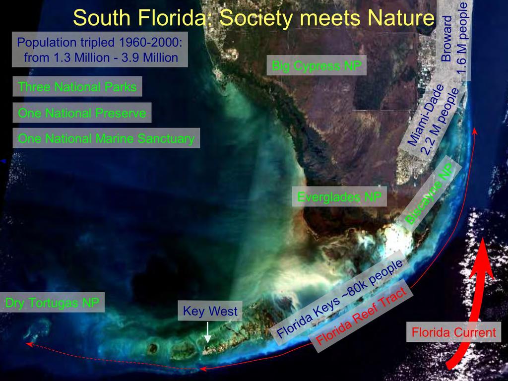
3 Florida Keys National Marine Sanctuary (FKNMS) An innovative network of marine zoning includes 25 no-take areas FKNMS established 1990 Dry Tortugas No-take area approved No-take SPAs approved 1997
 Mycteroperca bonaci (black grouper) 1500 m Jiangang Luo photo Eklund et al.")
4 Black Grouper Census at Carysfort Reef Carysfort SPA (July 1997)` North Carysfort (emergent) South Carysfort (emergent) Mycteroperca bonaci (black grouper) 1500 m Jiangang Luo photo Eklund et al. (2000) Depth 2-5 m 20 m 150 m
5 Black Grouper Census at Carysfort Reef Carysfort SPA (July 1997) Eklund et al. (2000) 1500 m M. bonaci counts (all seasons ) X
6 Black Grouper Census at Carysfort Reef Carysfort SPA (July 1997) Eklund et al. (2000) 1500 m M. bonaci counts (Jan & Dec 1998) X

7 A Problem...


8 One reason for this: no habitat maps > 20 m. 1 km 1994 on: high abundance of groupers 1998: 100 Black Groupers! 1997: Carysfort SPA Airphoto Classification Hardbottom Seagrass Patch Reefs Bare Sediment

9 Lack of habitat data for deep / turbid water > 50% of FKNMS!


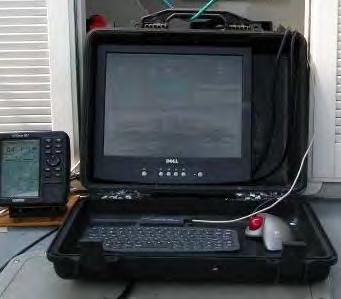
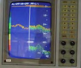
10 Acoustic survey (2003) with QTC-View V 1 km
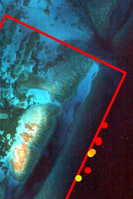
 Mixed rock/sediment Sediment B A 30 m Outlier 30 & 36 m ridges 50 m Outlier Aggregation Site")
11 SPA border Modern (Holocene) Reef: too shallow to survey Carysfort survey results A 30 m Outlier reef 30 m ridge 36 m ridge 50 m Outlier reef Shaded relief from bathymetry Seabed type from echo shape Hardbottom (reef) Mixed rock/sediment Sediment B A 30 m Outlier 30 & 36 m ridges 50 m Outlier Aggregation Site B

12 Carysfort survey results SPA border A Black grouper aggregation site On steepest part of 30 m outlier Inshore exposed 30, 36 m ridges Inshore exposed 50 m outlier Does this pattern hold for other aggregation sites in the Keys? B A Aggregation Site B
 Jiangang Luo photo Ocean Reef: Mutton")

")
13 Historical aggregation sites Bear Cut: Gag grouper Lutjanus analis (mutton snapper) Jiangang Luo photo Ocean Reef: Mutton Snapper Mycteroperca bonaci (black grouper) 15 km Davis Reef Yellowtail Snapper Carysfort Reef: Black Grouper Watsons Reef: Black Grouper Yellowtail Snapper Mutton Snapper Jiangang Luo photo Lutjanus chrysurus (yellowtail snapper) Jiangang Luo photo
 On steepest part of 30 m outlier Inshore Carysfort exposed (already 30, seen 36 earlier) m ridges Inshore exposed 50 m outlier 30 m ridge 30 m Outlier reef 36 m")
14 Watsons & Carysfort viewed together Black grouper & Yellowtail snapper Offshore steepest part of 30 m outlier Upstream Watsons of exposed reef (new 36 m this ridge slide) Downstream of patch reefs Black grouper (from earlier slide) On steepest part of 30 m outlier Inshore Carysfort exposed (already 30, seen 36 earlier) m ridges Inshore exposed 50 m outlier 30 m ridge 30 m Outlier reef 36 m ridge 50 m Outlier reef Mutton Snapper: Offshore steepest part of 30 m outlier On partially exposed face of 50 m outlier 12 km

15 Seabed type complements bathymetry Looks flat, but is really high-rugosity patch reefs Looks promising, but is really barren sediment slope 12 km

16 SPA border Davis Yellowtail snapper On steepest part of 30 m outlier Inshore of unexposed 30 m ridge, 50 m outlier 30 m Outlier reef 30 m ridge 50 m Outlier reef

17 Ocean Reef Mutton snapper Offshore steepest part of 30 m outlier On exposed 30 m ridge Inshore exposed 36 m ridge, 50 m outlier 30 m Outlier reef 30 m ridge 36 m ridge 50 m Outlier reef

18 Bear Cut Gag grouper Offshore steep part of 30 m outlier Downstream unexposed 30 / 36 m ridge 30 m Outlier reef 30/36 m ridge (?)
19 Upper Keys Aggregation Sites Model Original Hypothesis (Based on Carysfort) Aggregation sites expected at a point meeting three conditions : 1) On steepest part of 30 m outlier 2) Inshore exposed 30, 36 m ridges 3) Inshore exposed 50 m outlier 30 m Outlier reef Side view (depth profile) 30 / 36 m ridges 50 m Outlier reef Top view (depth contours)
20 Upper Keys Aggregation Sites Model Revised Model (Based on observations at additional Upper Keys sites) Aggregation sites expected within a band meeting three conditions: 1) On face or offshore of steepest part of 30 m outlier 2) Within 100 m (along shore) of exposed 30 / 36 m ridge 3) On face of or inshore exposed 50 m outlier How well do sites fit the revised model? Site Carysfort (Black) Y Y Y Watsons (Black and Yellowtail) Y Y Partial Davis (Yellowtail) Y N N Watsons (Mutton) Y Y Partial Ocean Reef (Mutton) Y Y Y Bear Cut (Gag) Y Maybe N


21 Relevance to Caribbean 200 km 5km
 both axes in meters (vertical exaggeration = 10x) b)")
22 Macintyre 1972: Shelf edge reefs on 40m terrace Eastern Caribbean Islands Anguilla St. John Montserrat Barbados Grenadines On all plots: a) both axes in meters (vertical exaggeration = 10x) b) red line marks 50 m depth
23 Summary Outlier reefs are: critical habitat in the Upper Fl Keys critical habitat elsewhere (probably) too deep to survey with imagery possible to survey with acoustics (or lidar maybe) Deep water survey needed when considering MPA boundaries: We don t want another Carysfort. Benefits of single beam Inexpensive Retrieves substrate type, not just bathymetry
24 Acknowledgements Funding from NOAA CRCP and ONR SPAG local knowledge from Roberto Torres Diving and boat ops support: Dave McClellan, Mark Miller, Jack Javech, Leah Harman, Sean Cimulluca, Doug Harper, Joe Contillo, Heather Balchowsky, Jen Schull, Neil Baertlein Anne-Marie Eklund initiated this project
Effective multi-agency collaboration improves spatial monitoring and planning in the Florida Keys
 Effective multi-agency collaboration improves spatial monitoring and planning in the Florida Keys Jim Bohnsack Southeast Fisheries Science Center NOAA Fisheries Service Miami, FL 1 The Managed Florida
Biogeographic Assessment of Florida Keys National Marine Sanctuary
 Biogeographic Assessment of Florida Keys National Marine Sanctuary NOAA National Centers for Coastal Ocean Science NOAA Florida Keys National Marine Sanctuary Florida Fish and Wildlife Commission Photos
Fish Aggregations in the Florida Keys
 Fish Aggregations in the Florida Keys Observations of Mutton Snapper on Riley s Hump Date and Station Numbers observed Moon phase 28 May 1 June 1999 1 fish in 3 of the 11 dives Full moon May 30* 31 July
Acoustic signatures of the seafloor: tools for predicting grouper habitat
 38 Abstract Groupers are important components of commercial and recreational fisheries. Current methods of diver-based grouper census surveys could potentially benefit from development of remotely sensed
Domain (island) wide estimates of mutton snapper (Lutjanus analis) abundance for three US Caribbean Islands based on habitat-derived densities
 wide estimates of mutton snapper (Lutjanus analis) abundance for three US Caribbean Islands based on habitat-derived densities") Domain (island) wide estimates of mutton snapper (Lutjanus analis) abundance for three US Caribbean Islands based on habitat-derived densities SEDAR REPORT # SEDAR14-AW2 Prepared May 2007 by Christopher
Domain (island) wide estimates of mutton snapper (Lutjanus analis) abundance for three US Caribbean Islands based on habitat-derived densities SEDAR REPORT # SEDAR14-AW2 Prepared May 2007 by Christopher
Geomorphometric Analysis of Nassau Grouper Spawning Aggregation Sites in Belize and the Cayman Islands
 http://www.landbigfish.com/fish/fish.cfm?id=58 Geomorphometric Analysis of Nassau Grouper Spawning Aggregation Sites in Belize and the Cayman Islands Shin Kobara and William D. Heyman Texas A&M University
1. What are the scientific names of red snapper, gag grouper, and scamp grouper? 2. What families do red snapper, gag grouper, and scamp belong to?
 NOAA Gray s Reef National Marine Sanctuary Acoustic Fish Tagging Project Activity: Interpretation of Data and Graphs Grades 9-12 Developed by C.J. Carroll and Cathy Sakas 9/3/2009 Use the available table
Towards Sustainable Multispecies Fisheries in the Florida Coral Reef Ecosystem
 Towards Sustainable Multispecies Fisheries in the Florida Coral Reef Ecosystem Jerald S. Ault University of Miami Rosenstiel School of Marine and Atmospheric Science Southern Florida coral reefs generated
Modeling effects of fishing closures in the Western Florida Shelf
 Modeling effects of fishing closures in the Western Florida Shelf David J. Die and Steven Saul* University of Miami * Currently SEFSC/NMFS/NOAA Outline Effects of fishing closures DWH Fishing closures
Improving fishermen awareness to reduce the presence of lobster traps in MPAs of the Florida Keys. Gabrielle Renchen & Tom Matthews
 Improving fishermen awareness to reduce the presence of lobster traps in MPAs of the Florida Keys Spiny Lobster Advisory Panel Meeting Key Largo, FL April 25, 2016 Gabrielle Renchen & Tom Matthews Florida
DESCRIPTION OF REEF FISH SPAWNING AGGREGATIONS AT MONA ISLAND PUERTO RICO
 DESCRIPTION OF REEF FISH SPAWNING AGGREGATIONS AT MONA ISLAND PUERTO RICO Michelle Schärer, Michael Nemeth, Alfonso Aguilar, Richard Appeldoorn Department of Marine Sciences, University of Puerto Rico,
South Atlantic proposed MPAs: : three years of pre- closure data on habitat and fish assemblages
 South Atlantic proposed MPAs: : three years of pre- closure data on habitat and fish assemblages Principal Investigators: Stacey L. Harter Andrew W. David NOAA Fisheries, Panama City, FL Similar project
Artificial Reef Program Biological Monitoring Update
 Artificial Reef Program Biological Monitoring Update Texas Parks and Wildlife Department Coastal Fisheries - Artificial Reef Program Brooke Shipley, Ph.D. Artificial Reef Program Over 4800 Acres 76 Established
Spawning Aggregation Evaluation. Utila January February 2009
 Spawning Aggregation Evaluation Utila January February 2009 Location Selection Selection considered fishermen and logistics Location 1: Joshua Swash Location 2: The Elbow The Elbow cancelled after January
Fisheries of the Caribbean, Gulf of Mexico, and South Atlantic; Reef Fish Fishery of Puerto Rico and the U.S. Virgin Islands;
 This document is scheduled to be published in the Federal Register on 06/11/2018 and available online at https://federalregister.gov/d/2018-12420, and on FDsys.gov BILLING CODE: 3510-22-P DEPARTMENT OF
Experimental Studies of Factors Affecting Coral Recruitment in La Parguera, Puerto Rico. Alina Szmant (UNCW) and Ernesto Weil (RUM)
 and Ernesto Weil (RUM)") Experimental Studies of Factors Affecting Coral Recruitment in La Parguera, Puerto Rico Alina Szmant (UNCW) and Ernesto Weil (RUM) The Problem: Regional Decline in Caribbean coral cover based on published
Experimental Studies of Factors Affecting Coral Recruitment in La Parguera, Puerto Rico Alina Szmant (UNCW) and Ernesto Weil (RUM) The Problem: Regional Decline in Caribbean coral cover based on published
VII. Marine debris distribution
 2008 Quick Look Report: Miller et al. VII. Marine debris distribution Background Fishing constitutes one of the most significant threats to marine biodiversity and ecosystem function, documented by a growing
Billing Code: P. Fisheries of the Caribbean, Gulf of Mexico, and South Atlantic;
 This document is scheduled to be published in the Federal Register on 02/19/2013 and available online at http://federalregister.gov/a/2013-03777, and on FDsys.gov Billing Code: 3510-22-P DEPARTMENT OF
BERMUDA GOVERNMENT Ministry of Health, Seniors and Environment Department of Environmental Protection
 BERMUDA GOVERNMENT Ministry of Health, Seniors and Environment Department of Environmental Protection Mailing Address: Botanical Gardens Phone: 441-236-4201 P.O. Box HM 834 169 South Road Fax: 441-236-7582
SEDAR 10 DW- 08. REVIEW OF TAGGING DATA FOR GAG GROUPER (Mycteroperca microlepis) FROM THE SOUTHEASTERN GULF OF MEXICO REGION
 FROM THE SOUTHEASTERN GULF OF MEXICO REGION") SEDAR 1 DW- 8 REVIEW OF TAGGING DATA FOR GAG GROUPER (Mycteroperca microlepis) FROM THE SOUTHEASTERN GULF OF MEXICO REGION 1985-25. THIS DOCUMENT SHOULD NOT BE CITED WITHOUT AUTHOR S PERMISSION. Mauricio
SEDAR 1 DW- 8 REVIEW OF TAGGING DATA FOR GAG GROUPER (Mycteroperca microlepis) FROM THE SOUTHEASTERN GULF OF MEXICO REGION 1985-25. THIS DOCUMENT SHOULD NOT BE CITED WITHOUT AUTHOR S PERMISSION. Mauricio
ESSENTIAL FISH HABITAT HABITAT AREAS OF PARTICULAR CONCERN (EFH-HAPC) AND CORAL HABITAT AREAS OF PARTICULAR CONCERN (C-HAPC)
 AND CORAL HABITAT AREAS OF PARTICULAR CONCERN (C-HAPC)") ESSENTIAL FISH HABITAT HABITAT AREAS OF PARTICULAR CONCERN () AND CORAL HABITAT AREAS OF PARTICULAR CONCERN (C-HAPC) Shrimp Sargassum All coastal inlets, all statedesignated habitats of particular importance
ESSENTIAL FISH HABITAT HABITAT AREAS OF PARTICULAR CONCERN () AND CORAL HABITAT AREAS OF PARTICULAR CONCERN (C-HAPC) Shrimp Sargassum All coastal inlets, all statedesignated habitats of particular importance
Florida Fish and Wildlife Conservation Commission (FWC)
") Florida Fish and Wildlife Conservation Commission (FWC) Mason Smith Florida Fish and Wildlife Conservation Commission Division of Marine Fisheries Management Version 1 FWC Mission To manage fish and wildlife
Florida Fish and Wildlife Conservation Commission (FWC) Mason Smith Florida Fish and Wildlife Conservation Commission Division of Marine Fisheries Management Version 1 FWC Mission To manage fish and wildlife
Glover s Reef Marine Reserve Long-term Atoll Monitoring Program (LAMP)
") Glover s Reef Marine Reserve Long-term Atoll Monitoring Program (LAMP) Report for the period July 2004 ust 2011 February 2012 Wildlife Conservation Society, Global Conservation Program, Belize Belize City,
Glover s Reef Marine Reserve Long-term Atoll Monitoring Program (LAMP) Report for the period July 2004 ust 2011 February 2012 Wildlife Conservation Society, Global Conservation Program, Belize Belize City,
SCDNR Research and Monitoring: Habitat Needs of Different Life History Stages of Managed Reef Species
 SCDNR Research and Monitoring: Habitat Needs of Different Life History Stages of Managed Reef Species Patrick J. Harris George R. Sedberry Marine Resources Research Institute SCDNR SedberryG@dnr.sc.gov
Essential Fish Habitat Description Atlantic cod (Gadus morhua)
") Description Atlantic cod (Gadus morhua) In its Report to Congress: Status of the Fisheries of the United States (September 1997), NMFS determined the Gulf of Maine stock of cod is considered overfished,
Description Atlantic cod (Gadus morhua) In its Report to Congress: Status of the Fisheries of the United States (September 1997), NMFS determined the Gulf of Maine stock of cod is considered overfished,
Islands in the Stream: A Concept for the Gulf of Mexico
 Islands in the Stream: A Concept for the Gulf of Mexico Marine Protected Areas Federal Advisory Committee Great Lakes Maritime Heritage Center Alpena, Michigan October 24, 2007 Billy D. Causey, Ph.D. Regional
Bottomfish Habitat and Restricted Fishing Area Analysis
 Bottomfish Habitat and Restricted Fishing Area Analysis Robert O Conner, NOAA National Marine Fisheries Service Chris Kelley, Hawaii Undersea Research Laboratory, University of Hawaii Study Area Essential
Evolution of Deepwater Coral Protection in the Southeast U.S
 Evolution of Deepwater Coral Protection in the Southeast U.S Tina Udouj, Florida Fish and Wildlife Conservation Commission Roger Pugliese, South Atlantic Fishery Management Council Overview Deepwater Corals
Flower Garden Banks National Marine Sanctuary Management Plan Revision
 Flower Garden Banks National Marine Sanctuary Management Plan Revision G.P. Schmahl Sanctuary Superintendent Beyond the Horizon May 12, 2011 Flower Garden Banks National Marine Sanctuary Stetson Bank
WALTON COUNTY NRDA ARTIFICIAL REEF PROGRAM
 WALTON COUNTY NRDA ARTIFICIAL REEF PROGRAM Melinda Gates Lauren Floyd Kathryn Brown Beau Suthard, PG Franky Stankiewicz Walton County - Coastal Resource Liaison APTIM - Senior Marine Biologist APTIM -
Essential Fish Habitat: An overview of the consultation requirement for the American Association of Port Authorities
 Essential Fish Habitat: An overview of the consultation requirement for the American Association of Port Authorities National Marine Fisheries Service, Southeast Regional Office Habitat Conservation Division,
Challenges in determining water surface in airborne LiDAR topobathymetry. Amar Nayegandhi, Dewberry 15 th Annual JALBTCX Workshop, June 11 th 2014
 Challenges in determining water surface in airborne LiDAR topobathymetry Amar Nayegandhi, Dewberry 15 th Annual JALBTCX Workshop, June 11 th 2014 Why topobathy LiDAR? Complements acoustic (multi-beam sonar)
Are the Coral Reef Finfish Fisheries of South Florida Sustainable?
 Proceedings of the 11 th International Coral Reef Symposium, Ft. Lauderdale, Florida, 7-11 July 28 Session Number 22 Are the Coral Reef Finfish Fisheries of South Florida Sustainable? J.S. Ault, S.G. Smith,
MAHS Field School 2018 Pickles Reef Florida Keys National Marine Sanctuary
 MAHS Field School 2018 Pickles Reef Florida Keys National Marine Sanctuary MAHS returned to Pickles Reef in June of 2018 to hold its annual field school. Pickles Reef lies about 6 miles from Key Largo
VIII. Marine Debris. Background
 VIII. Marine Debris Background Fishing constitutes one of the most significant threats to marine biodiversity and ecosystem function, as evidenced by a significant body of information on the numerous impacts
Acoustic tagging: abundance indices and habitat use Juvenile southern bluefin tuna in Western Australia
 Acoustic tagging: abundance indices and habitat use Juvenile southern bluefin tuna in Western Australia Alistair Hobday, Ryo Kawabe, Ko Fujioka, Tomoyuki Itoh, Kazu Miyashita, Yoshimi Takao Recruitment
Eastern Shore Islands Area of Interest Community Newsletter
 Eastern Shore Islands Area of Interest Community Newsletter Fall 2018 1ỊNTRODUCTION In addition to information on our Fisheries and Oceans Canada (DFO) website, we have now created a seasonal, community
Unless otherwise noted, images throughout the presentation are by FWC.
 This presentation provides an update on current programs in place to collect catch and effort data for Florida s saltwater recreational fisheries, including the Gulf Reef Fish Survey (GRFS) and potential
Utilizing Vessel Based Mobile LiDAR & Bathymetry Survey Techniques for Survey of Four Southern California Breakwaters
 Utilizing Vessel Based Mobile LiDAR & Bathymetry Survey Techniques for Survey of Four Southern California Breakwaters Western Dredging Association: Pacific Chapter September 2012 Insert: Pipe Location
PUBLIC HEARING GUIDE 10/4/12
 PUBLIC HEARING GUIDE 10/4/12 Framework Action to set the 2013 Gag Recreational Fishing Season and Bag Limit and Modify the February-March Shallow-Water Grouper Closed Season Photos courtesy of: Glen Balinger,
Reef Fish Amendment 32 Gag and Red Grouper
 AMENDMENT GUIDE 11/2/11 Reef Fish Amendment 32 Gag and Red Grouper Provisions in the Magnuson-Stevens Fishery Conservation and Management Act require regional fishery management councils to develop annual
NSUWorks. Nova Southeastern University. Kirk Kilfoyle Nova Southeastern University Oceanographic Center
 Nova Southeastern University NSUWorks Marine & Environmental Sciences Faculty Reports Department of Marine and Environmental Sciences 6-3-214 Coral Reef Conservation Program (CRCP) Local Action Strategy
Recreational - Charter Fishing Working Group. Recommendations to the Sanctuary Advisory Council
 Recreational - Charter Fishing Working Group Recommendations to the Sanctuary Advisory Council Capt. Will Benson, Sanctuary Advisory Council, Charter Flats Fishing, Working Group Chair Nicole Uibel, FKNMS
/ Advice May 2011
 1.5.1.3/1.5.4.1 Advice May 2011 ECOREGION SUBJECT General advice Update of cold-water coral and sponge maps and the information underpinning such maps on Vulnerable Marine Habitats (including Hatton and
Assessment of the Introduced Lionfish in Everglades and Dry Tortugas National Parks
 Assessment of the Introduced Lionfish in Everglades and Dry Tortugas National Parks Tracy A. Ziegler, Ph.D. Fisheries Biologist National Park Service Problem Sightings of lionfish at Dry Tortugas (DRTO)
Teachers copy. 1. What are the scientific names of red snapper, gag grouper, and scamp grouper?
 NOAA Gray s Reef National Marine Sanctuary Acoustic Fish Tagging Project Activity: Interpretation of Data and Graphs Grades 9-12 Developed by C.J. Carroll and Cathy Sakas 9/3/2009 Teachers copy Use the
Updated landings information for the commercial fisheries in Puerto Rico with emphasis on silk and queen snapper and parrotfish fisheries
 Updated landings information for the commercial fisheries in Puerto Rico with emphasis on silk and queen snapper and parrotfish fisheries Nancie J. Cummings and Daniel Matos-Caraballo SEDAR 26-DW-03 Date
VIDEO TRANSCRIPT. A Proposal to Expand the Flower Garden Banks National Marine Sanctuary An interview with Sanctuary Superintendent, G.P.
 VIDEO TRANSCRIPT A Proposal to Expand the Flower Garden Banks National Marine Sanctuary An interview with Sanctuary Superintendent, G.P. Schmahl (Opening scene of Flower Garden Banks National Marine Sanctuary
Evaluation of the Klein HydroChart 3500 Interferometric Bathymetry Sonar for NOAA Sea Floor Mapping
 Evaluation of the Klein HydroChart 3500 Interferometric Bathymetry Sonar for NOAA Sea Floor Mapping Yuhui Ai, Straud Armstrong and Dean Fleury L-3 Communications Klein Associates, Inc. 11 Klein Dr. Salem,
Deep-sea coral protection zones and management measures
 Deep-sea coral protection zones and management measures This presentation was originally provided to the New England Fishery Management Council on April 26, 2012 in Mystic, CT. Recent updates related to
Monetisation of sustainable business models for Satellite Derived Bathymetry
 Monetisation of sustainable business models for Satellite Derived Bathymetry Who are we? We are a UK & UAE based company specialising in satellite derived seabed & environmental mapping products We aim
Marine Recreational Information Program Transition to Improved Survey Designs
 Marine Recreational Information Program Transition to Improved Survey Designs David Gloeckner Southeast Fisheries Science Center Richard Cody Office of Science & Technology Improved Survey Designs Fishing
Minimum Stock Size Threshold (MSST) for reef fish stocks with low natural mortality
 for reef fish stocks with low natural mortality") Tab B, No. 13 1/15/15 Minimum Stock Size Threshold (MSST) for reef fish stocks with low natural mortality 1 0.75 M F / FMSY 0.5 0.25 0 0 0.25 0.5 0.75 1 1.25 1.5 B / B MSY Options Paper to the Fishery
Tab B, No. 13 1/15/15 Minimum Stock Size Threshold (MSST) for reef fish stocks with low natural mortality 1 0.75 M F / FMSY 0.5 0.25 0 0 0.25 0.5 0.75 1 1.25 1.5 B / B MSY Options Paper to the Fishery
Deep-sea corals of the USA: Surveys, maps, & models for exploration and management
 Deep-sea corals of the USA: Surveys, maps, & models for exploration and management Heather Coleman Robert McGuinn Tom Hourigan Peter Etnoyer Matt Dornback Daniel Wagner Dan Dorfman Renee King Deep Sea
Fishing Volusia County s Artificial Reefs
 Fishing Volusia County s Artificial Reefs Photo Courtesy John Baller Jr. Photo Courtesy Captain Don Martin Preparation and Safety The single most important thing about boating, fishing, or diving is to
Essential Fish Habitat Description White hake (Urophycis tenuis)
") Description White hake (Urophycis tenuis) In its Report to Congress: Status of the Fisheries of the United States (September 1997), NMFS determined white hake is not currently overfished, but it is approaching
Description White hake (Urophycis tenuis) In its Report to Congress: Status of the Fisheries of the United States (September 1997), NMFS determined white hake is not currently overfished, but it is approaching
Field Protocol for Monitoring Coral Reef Fisheries Resources in Belize
 Field Protocol for Monitoring Coral Reef Fisheries Resources in Belize Charles A. Acosta, PhD Wildlife Conservation Society Glover s Reef Marine Research Station P.O. Box 272 Dangriga, Belize and Department
Synopsis. Site Characterization for Biscayne National Park: Assessment of Fisheries Resources and Habitats
 Synopsis Site Characterization for Biscayne National Park: Assessment of Fisheries Resources and Habitats Jerald S. Ault, Steven G. Smith, Geoffrey A. Meester, Jiangang Luo, and James A. Bohnsack* University
Angler Heterogeneity and Species- Specific Demand for Recreational Fishing in the Southeast United States
 Angler Heterogeneity and Species- Specific Demand for Recreational Fishing in the Southeast United States Tim Haab (Ohio State University) Rob Hicks (College of William and Mary) Kurt Schnier (University
Implementing the Dry Tortugas National Park. Research Natural Area Science Plan The 5-Year Report
 Florida Fish and Wildlife Conservation Commission National Park Service U.S. Department of the Interior South Florida Natural Resources Center Everglades and Dry Tortugas National Parks Implementing the
Methods and Lessons Learned from a Fisheries- Independent Reef Fish Sampling Program in the Florida Keys, USA
 Methods and Lessons Learned from a Fisheries- Independent Reef Fish Sampling Program in the Florida Keys, USA Alejandro Acosta Florida Fish and Wildlife Conservation Commission Fish and Wildlife Research
Working Group Meeting Summary
 Florida Keys National Marine Sanctuary Marine Zoning & Regulatory Review Ecosystem Protection: Ecological Reserves / Preservation Areas and Wildlife Protection July 8 & 9, 2014 Working Group Meeting Summary
National Oceanic and Atmospheric Administration (NOAA)/ Mulberry Phosphate Trustee Council September 12, 2013
/ Mulberry Phosphate Trustee Council September 12, 2013") OYSTER REEF CREATION PROJECT DESIGN AND IMPLEMENTATION IN HILLSBOROUGH BAY, FLORIDA TAMPA BAY REGIONAL PLANNING COUNCIL AGENCY ON BAY MANAGEMENT MEETING National Oceanic and Atmospheric Administration
OYSTER REEF CREATION PROJECT DESIGN AND IMPLEMENTATION IN HILLSBOROUGH BAY, FLORIDA TAMPA BAY REGIONAL PLANNING COUNCIL AGENCY ON BAY MANAGEMENT MEETING National Oceanic and Atmospheric Administration
Case Study 3. Case Study 3: Cebu Island, Philippines MPA Network 10
 Case studies of mpa networks Case Study 3: Cebu Island, Philippines MPA Network 10 Location and background Cebu Island in the Philippines lies in the center of the Visayan Islands, known as an area high
SOUTH ATLANTIC FISHERY MANAGEMENT COUNCIL
 1 SOUTH ATLANTIC FISHERY MANAGEMENT COUNCIL ONE SOUTHPARK CIRCLE, SUITE 306 CHARLESTON, SOUTH CAROLINA 29407-4699 TEL 843/571-4366 or FAX 843/769-4520 Toll Free 1-866/SAFMC-10 E-mail: safmc@safmc.net Web
National Marine Fisheries Service, Habitat Conservation Division:
 National Marine Fisheries Service, Habitat Conservation Division: Essential Fish Habitat, South East Florida Coral Reef Initiative and Land- Based Sources of Pollution effects on Critical Fisheries Habitats
Assessment of Artificial Reefs Impacted by Hurricane Michael
 Assessment of Artificial Reefs Impacted by Hurricane Michael Jeff Renchen, Keith Mille, Devin Resko, Christine Kittle Florida Fish and Wildlife Conservation Commission Division of Marine Fisheries Management
UNDERWATER ARCHAEOLOGY Pickles Reef Florida Keys National Marine Sanctuary
 UNDERWATER ARCHAEOLOGY Pickles Reef Florida Keys National Marine Sanctuary MAHS Survey and Field School 2011 MAHS returned to Florida in June of 2011 to continue a survey of Pickles Reef begun in 2010.
OECS Regional Engineering Workshop September 29 October 3, 2014
 B E A C H E S. M A R I N A S. D E S I G N. C O N S T R U C T I O N. OECS Regional Engineering Workshop September 29 October 3, 2014 Coastal Erosion and Sea Defense: Introduction to Coastal Dynamics David
An Overview of Methods for Estimating Absolute Abundance of Red Snapper in the Gulf of Mexico
 An Overview of Methods for Estimating Absolute Abundance of Red Snapper in the Gulf of Mexico JM Drymon 1, Greg Stunz 2 1. Mississippi State University, Coastal Research and Extension Center 2. Harte Research
East Central Florida Region Matt Culver, Brevard County James Gray, Indian River County Jim Oppenbourn, St. Lucie County Kathy Fitzpatrick, Martin
 James Gray, Indian River County January 14, 2015 East Central Florida Region Matt Culver, Brevard County James Gray, Indian River County Jim Oppenbourn, St. Lucie County Kathy Fitzpatrick, Martin County
Assessing the Accuracy of High Spatial Resolution Effort Data
 Assessing the Accuracy of High Spatial Resolution Effort Data Southwest Fisheries Science Center, Ecology Division Comparing VMS and Logbook Data in the California Groundfish Trawl Fishery Alice Thomas-Smyth,
Barotrauma in Atlantic Coast Fisheries. Chip Collier March 2011
 Barotrauma in Atlantic Coast Fisheries Chip Collier March 2011 Atlantic Ecosystems Coastline 2,100 miles Two Large Marine Ecosystems Northern Southern Three Councils New England Mid Atlantic South Atlantic
Zooplankton community structure in the northern Gulf of Mexico: Implications for ecosystem management
 Zooplankton community structure in the northern Gulf of Mexico: Implications for ecosystem management By Andrew F. Millett Dauphin Island Sea Lab University of South Alabama W. Monty Graham, Glenn A. Zapfe,
Figure 4, Photo mosaic taken on February 14 about an hour before sunset near low tide.
 The Impact on Great South Bay of the Breach at Old Inlet Charles N. Flagg and Roger Flood School of Marine and Atmospheric Sciences, Stony Brook University Since the last report was issued on January 31
Characterizing the Fish Assemblages of Cordell Bank National Marine Sanctuary
 Characterizing the Fish Assemblages of Cordell Bank National Marine Sanctuary Dale Roberts & Many Others NATIONAL MARINE SANCTUARIES TM CORDELL BANK Point Reyes Lighthouse Cordell Bank I&M and SWiM* Similarities
An IOOS Operational Wave Observation Plan Supported by NOAA IOOS Program & USACE
 An IOOS Operational Wave Observation Plan Supported by NOAA IOOS Program & USACE R.E. Jensen, W.A. Birkemeier and W. Burnett JCOMM-Workshop on Wave Measurements from Buoys Wave Information to Application
Information needs for resource management in and around Florida Bay
 Information needs for resource management in and around Florida Bay Florida Bay and Adjacent Marine Systems Science Conference December 8-, 28 David E. Hallac Everglades and Dry Tortugas National Parks,
August 3, Prepared by Rob Cheshire 1 & Joe O Hop 2. Center for Coastal Fisheries and Habitat Research Beaufort, NC
 SEDAR 19-DW05 Evaluation of the 1960, 1965, and 1970 U.S. Fish and Wildlife Service salt-water angling survey data for use in the stock assessment of red grouper (Southeast US Atlantic) and black grouper
Examples of Carter Corrected DBDB-V Applied to Acoustic Propagation Modeling
 Naval Research Laboratory Stennis Space Center, MS 39529-5004 NRL/MR/7182--08-9100 Examples of Carter Corrected DBDB-V Applied to Acoustic Propagation Modeling J. Paquin Fabre Acoustic Simulation, Measurements,
Summary of current information available on Coastal Pelagic Species with emphasis on Northern Anchovy
 Agenda Item H.3.a Supplemental SWFSC PowerPoint (Electronic Only) November 2015 Summary of current information available on Coastal Pelagic Species with emphasis on Northern Anchovy Gerard DiNardo, Dale
Blue Star Fishing Guides
 Blue Star Fishing Guides Capt. Will Benson, Sanctuary Advisory Council, Charter Flats Fishing Nicole Uibel, FKNMS Program Coordinator December 12, 2017 Mission and Goal Mission The mission of Blue Star
and found that there exist a significant overlap between the billfish resources and the exploitation activities targeting tunas and mahi mahi.
 Executive Summary Report 2016 Billfish Research in the Eastern Pacific Ocean Rosenstiel School of Marine and Atmospheric Science University of Miami January 2017 During 2016, the Eastern Pacific Ocean
Semi-Annual Progress Report for: June 1, November 30, 2004
 Combining a Partnership Among Researchers, Commercial Recreational, and Recreational-For-Hire Fishers With a Cooperative T~gging Program to Elucidate the Life History and Habit Utilization of Select Reef
Essential Fish Habitat Description Atlantic herring (Clupea harengus)
") Description Atlantic herring (Clupea harengus) In its Report to Congress: Status of the Fisheries of the United States (September 1997), NMFS determined Atlantic herring is not currently overfished. This
Description Atlantic herring (Clupea harengus) In its Report to Congress: Status of the Fisheries of the United States (September 1997), NMFS determined Atlantic herring is not currently overfished. This
A PHYSICAL AND BIOLOGICAL SURVEY OF THE MID-REACH MITIGATION REEF SET NUMBER 1
 A PHYSICAL AND BIOLOGICAL SURVEY OF THE MID-REACH MITIGATION REEF SET NUMBER 1 John M. Hearin, Ph.D., P.E. 1 ; Geoff Swain, Ph.D. 2 ; Robert Weaver, Ph.D., P.E. 2 ; Kelli Z. Hunsucker, Ph.D. 2 ; Caglar
THE POLARIMETRIC CHARACTERISTICS OF BOTTOM TOPOGRAPHY RELATED FEATURES ON SAR IMAGES
 THE POLARIMETRIC CHARACTERISTICS OF BOTTOM TOPOGRAPHY RELATED FEATURES ON SAR IMAGES Taerim Kim Professor, Ocean System Eng. Dept. Kunsan University Miryong Dong San 68, Kunsan, Jeonbuk, Korea, trkim@kunsan.ac.kr
ABSTRACT INTRODUCTION
 Sengupta, M. and Dalwani, R. (Editors). 2008 Proceedings of Taal2007: The 12 th World Lake Conference: 1022-1027 Water Erosion Control Using the Fetch Calculator. Applications for Constructed Wetlands
Eglin Air Force Base, FL
 Determining Marine Movement and Behavior of the Gulf Sturgeon in the Gulf Sturgeon Critical Habitat of the Gulf Testing and Training Range and Santa Rosa Island Complex Bob Miller/J. Mike Nunley /Amanda
United Nations Environment Programme
 UNITED NATIONS United Nations Environment Programme Distr. LIMITED EP UNEP(DEPI)/CAR WG.36/INF. 12 19 November 2014 Original: ENGLISH Sixth Meeting of the Scientific and Technical Advisory Committee (STAC6)
Coral Habitat Areas Considered for Management in the Gulf of Mexico
 Coral Habitat Areas Considered for Management in the Gulf of Mexico 05/2018 Leiopathes glaberrima with Eumunida picta Leiopathes sp. Lophelia reef Deep-sea corals Table of Contents What is a Public Hearing?...1
Severe Winds Due To Mountain Waves Along the Western Foothills of the Southern Appalachian Mountains
 Severe Winds Due To Mountain Waves Along the Western Foothills of the Southern Appalachian Mountains by David M. Gaffin: National Weather Service, Morristown, TN Matt Hinkin: WATE-TV Chief Meteorologist,
Ecological Interactions in Coastal Marine Ecosystems: Rock Lobster
 Ecological Interactions in Coastal Marine Ecosystems: Rock Lobster Progress Report to 3 November Lachlan MacArthur and Glenn A. Hyndes Centre for Ecosystem Management, Edith Cowan University, 1 Joondalup
Florida s Artificial Reef Monitoring Efforts
 Florida s Artificial Reef Monitoring Efforts Prepared by Keith Mille March 14, 2016 Dive assessment of the Oriskany Reef, October 2006. Photo by Keith Mille Florida Fish and Wildlife Conservation Commission
GFCM - SAC-SCESS-SCMEE-SCSA Transversal Workshop on Spatial Based Fishery Management. 6-8 Feb 2012
 GFCM - SAC-SCESS-SCMEE-SCSA Transversal Workshop on Spatial Based Fishery Management 6-8 Feb 2012 A conceptual framework for the protection of vulnerable habitats impacted by fishing activities in the
Red Snapper distribution on natural habitats and artificial structures in the northern Gulf of Mexico
 Red Snapper distribution on natural habitats and artificial structures in the northern Gulf of Mexico SEFSC Mandy Karnauskas and John Walter, NMFS SEFSC Miami Matthew Campbell and Adam Pollack, NMFS SEFSC
Oceanic Society Reef Research Team: Nicole Crane, Avigdor Abelson, Peter Nelson, Giacomo Bernardi, Michelle Paddack, Kate Crosman
 The coral reef of Tamil (Yap, FSM): Preliminary ecological assessment of reef state and fish assemblages, and potential of conservation for sustainable use Report compiled by vigdor belson, Peter Nelson
Citizen Science Based Survey GBR Far North Dive Trip 2016 April 18-26
 Citizen Science Based Survey GBR Far North Dive Trip 2016 April 18-26 Chris Roelfsema Karen Johnson Douglas Stetner Trevor Baerenger Peran Brady May 2016 GBR Far North Citizen Science Trip 5 May 2016 1
CHARACTERIZING THE BEACH MORPHOLOGY OF SAN SALVADOR, BAHAMAS
 Middle States Geographer, 5, 38:61-68 CHARACTERIZING THE BEACH MORPHOLOGY OF SAN SALVADOR, BAHAMAS Joseph Gould and Stephen Vermette Department of Geography and Planning Buffalo State College Buffalo,
Seagrass surveys must be conducted between the dates of April 1 st and October 31 st with the following exceptions:
 Florida Fish and Wildlife Conservation Commission (FWC) Recommended Survey Protocols for Estuarine and Marine Submerged Aquatic Vegetation (SAV) related to Permitting Applications 12/14/2011 DRAFT 1) Survey