GENERAL. 1. Description
|
|
|
- Hannah Stevens
- 6 years ago
- Views:
Transcription
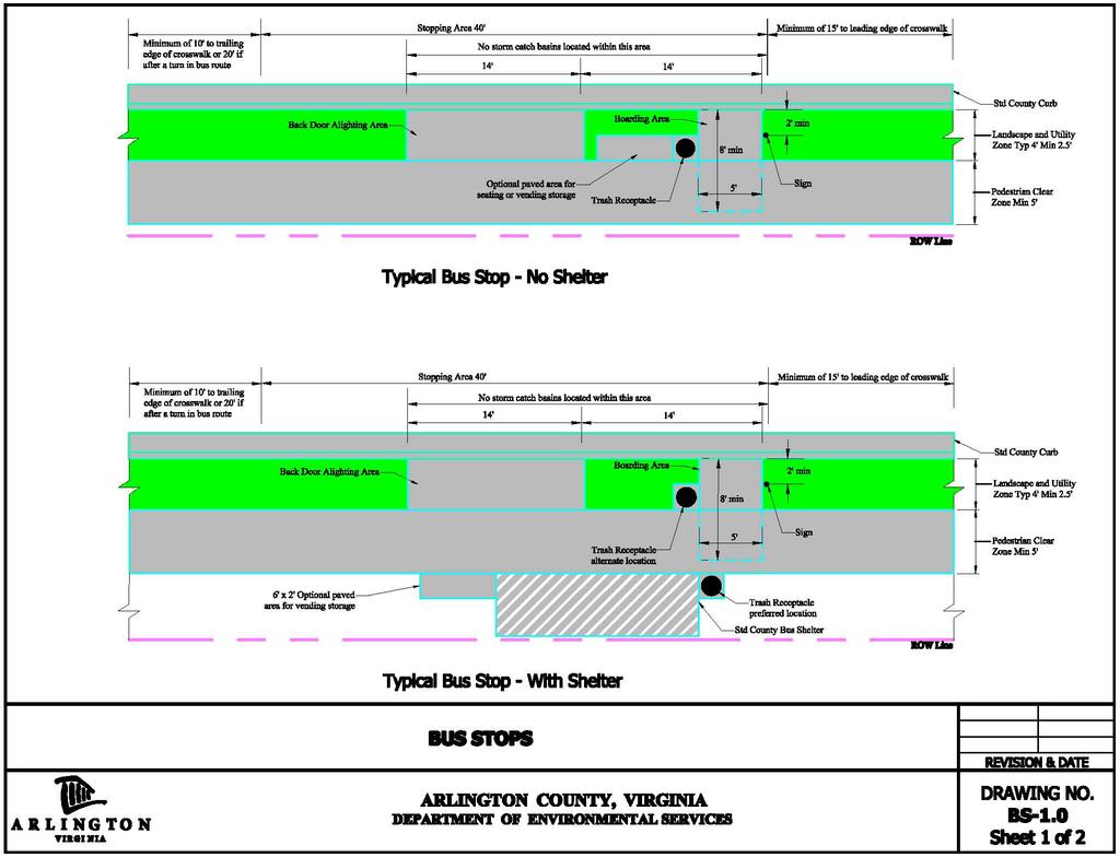
1 GENERAL 1. Description This standard identifies minimum requirements that shall be met for all Bus Stops in the design and construction of elements for Arlington County Horizontal Design Standards. This standard meets the County s guiding principles for increasing pedestrian safety and accessibility, decreasing county infrastructure costs and balancing the use of the Right-of- Way between all modes of transportation. 2. Related Arlington County Standards A. Arlington County Construction Standards and Specifications B. Arlington County Horizontal Standards H-3.3 Curb Extensions C. Arlington County Horizontal Standards H-X.X Sidewalks D. Arlington County Horizontal Standards H-X.X On Street Parking E. Arlington County Master Transportation Plan 3. Applicable Standards and Specifications A. Americans with Disabilities Act - Accessibility Guidelines for Building and Facilities (ADAAG) B. American with Disabilities Accessibility Guidelines for Public Rights-of-Way (PROWAG) 4. Quality Assurance A. Reserved 5. Submittals A. Design and placement of all bus stops shall be approved by both the DES Transit Bureau Chief and DES Transportation Engineering and Operations (TE&O) Bureau Chief DESIGN CONSIDERATIONS A. Purpose The purpose of a bus stop is to provide a safe, accessible, easily identifiable, and comfortable area for waiting, boarding, and alighting of bus passengers 1
2 B. Definitions 1. Bus Stop - A bus stop is an area used for the waiting, boarding and alighting of bus passengers, and the roadway area needed for the bus to service the stop. Bus stops typically include the street and curb space, sidewalk area, signing, and associated amenities for bus passengers. There are four general placement types for bus stops: a. Near side bus stop is located in advance of an intersection, before the crosswalk, in the direction of travel. b. Far side bus stop is located immediately beyond an intersection, past the crosswalk, in the direction of travel. c. Mid Block bus stop is located between intersections. d. Off Street bus stop is not located on the street. 2. Elements a. Signs post and sign panel (Flag) indicating the presence of a bus stop and used by the bus operator to gauge where to stop the vehicle. Also used to convey information to passengers. b. Boarding area an ADA compliant paved surface adjacent to the sign used by boarding passengers to enter the bus. c. Waiting area typically a paved surface within or adjacent to the pedestrian clear zone used for waiting passengers. The boarding area may be included within the waiting area. If provided bus stop amenities are located within the waiting area. d. Transit vehicle areas i. Stopping area The portion of the roadway used by the bus to stop and wait for the boarding and alighting of passengers. This can include in-lane stopping areas where the bus remains within the active travel lane including bicycle lanes. On street parking restrictions may be required. ii. Moving area The portion of the roadway used by the bus to approach and depart the bus stop. On street parking restrictions may be required if a curb extension is not present e. Back door alighting area - typically a paved surface within or adjacent to the pedestrian clear zone used by passengers exiting the rear doors of a bus. f. Bus pad - The bus pad is a concrete pavement area within the roadway at the bus stopping area to bring greater durability and longevity to the roadway pavement under frequent braking action by buses. A bus pad is not always an included element. 3. Amenities structures or devices that may be included at a bus stop for passenger comfort. a. Shelter A free standing structure including a roof at a minimum and may include weather protection panels on the front, rear and sides. A shelter is placed within the waiting area. b. Seating A structure located at a bus stop for passenger comfort. Seating may consist of either a bench or lean bar. 2
3 c. Lighting Lights located within or adjacent to the waiting area that are not part of the street lighting system. d. Heating may be provided for passenger environmental comfort or to melt ice and snow. e. Information Systems A static and or dynamic system providing additional passenger information. f. Fare Vending Equipment An electronic device used for the dispensing of transit fare media. g. Trash Receptacle A container for the deposit of trash or recyclables either free standing or mounted to a shelter. h. Bike Parking a structure, device or accommodation for the storage of bicycles. i. Publication Vending Area - area used for the distribution and vending of periodicals. C. Applicability PLACEMENT DESIGN These standards apply to all public transportation bus stops that in whole or in part occupy public rights-of-way or dedicated easements. A. Placement 1. The placement of a bus stop shall be determined through consultation with the TE&O and Transit Bureau chiefs to ensure compatibility and consistency with County transportation planning and operations. 2. Consideration for the placement of a bus stop include: a. Ridership demand, especially for seniors and persons with disabilities b. Bus routing and operations c. Vertical and horizontal sight distance d. Presence of sidewalks e. Available right-of-way f. Signalization and marked crosswalks g. Obstructions, such as utility poles, structures, and significant trees h. Adjacent property use i. Curb space use j. Traffic operations and safety k. Placement of nearby bus stops A. Elements 1. Signs Sign post shall be placed a minimum of 2 from back of curb. Sign panels shall be installed no lower than 7 from the bottom of the panel to the sidewalk. 3
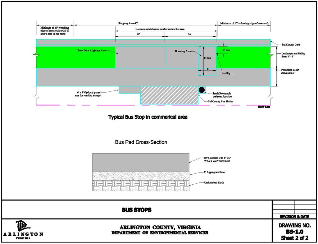
4 2. Boarding area This area shall be 5 wide (parallel to curb) and 8 long(transverse to curb), connected to the pedestrian clear zone, located adjacent to the bus stop sign and may extend into the pedestrian clear zone. This area shall remain obstacle free. The maximum slope perpendicular to the curb shall be 2 percent. 3. Transit vehicle areas a. Stopping area This area shall be 40 long. If a bus pad is included it shall be a minimum of 40 long and the full width of the active lane width. b. Moving areas i. For near side bus stops this area shall be 60 long and located before the stopping area. (The stopping area plus moving area is 100 long.) ii. For far side bus stops this area shall be 30 long located after the stopping iii. area. (The stopping area plus moving area is 70 long.) For mid block bus stops this area shall be 90 long with 60 located before and 30 after the stopping area. (The stopping area plus moving area is 130 long.) c. Back door alighting area this area shall begin 14 from the sign and end 28' from the sign and shall be connected to the pedestrian clear zone. This area shall remain obstacle free. 4. Bus stops on curb extensions a. The minimum tangent length of a curb extension is 40 feet. Refer to Arlington County Horizontal Standards H-3.3 Curb Extensions for further information. B. Amenities 1. Shelter - The County has two standard styles of bus shelters. a. Type 1 Traditional Bus Shelter i. 12 long x 5 wide x 7 high ii. 12 long x 4 wide x 7 high iii. 10 long x 3 wide x 7 high for use in constrained settings b. Type 2 Modern Styled Bus Shelter i. 16 long x 5 wide x 7 high ii. 12 long x 5 wide x 7 high iii. 10 long x 3 wide x 7 high for use in constrained settings Bus shelter placement shall follow the layout options shown in Drawing No. BS In cases where recommended layouts are not feasible, bus shelters shall be positioned in such a way to maintain. a. Clear 5 wide route from the waiting area inside the shelter to the boarding area. b. Clear 5 wide route from the back door alighting area to the pedestrian clear zone. 4
5 2. Seating a. Seating shall be placed on a paved surface. This surface shall include a 3 x 4 area for wheelchair use and may be part of the backdoor alighting area. b. Seating placed outdoors shall not encroach upon the boarding area or the pedestrian clear zone. c. Seating placed within shelters shall not encroach upon the ADA accessibility of the shelter. An area 3 wide and the depth of the shelter shall be provided for wheelchair use within the shelter. d. It is preferred that seating not be placed closer than 3 from the curb or 6 from the curb if a travel lane is directly adjacent to the curb. 3. Lighting and Information Systems a. On a case by case basis two 2-inch HDPE conduits may be placed as required for future uses. 4. Trash receptacles Receptacles are required at all bus stops that have shelters. Trash receptacles are preferred at all bus stops. Only County approved trash receptacles shall be installed. In some locations blast resistant designs may be desirable. Trash receptacles shall not infringe upon the boarding area or the pedestrian clear zone. 5. Publication Vending Area A 2 x 6 concrete pad may be provided on a case by case basis. Vending storage shall not be located within the boarding area, back door alighting area, shelters, or the pedestrian clear zone. 6. Bus Pad - A bus pad may be included at bus stops with high frequency of service, e.g. greater than four buses per hour. C. Materials 1. The standard material used for bus stops is poured in place concrete. 2. Materials other than poured in place concrete may be used in limited installations on a case by case basis. 3. All alternate materials shall be ADA compliant. 4. Bus pads Shall be 10 thick reinforced concrete with welded wire fabric 6 x 6 W2.9 x W2.9 over a 6 aggregate base. 5
6 DETAILS 6
7 7
CURBSIDE ACTIVITY DESIGN
 5 CURBSIDE ACTIVITY DESIGN This chapter provides design guidance for separated bike lanes adjacent to curbside activities including parking, loading and bus stops. Typical configurations are presented
ROUNDABOUTS/TRAFFIC CIRCLES
 GENERAL 1. Description This standard identifies minimum requirements that shall be met for Roundabouts and Neighborhood Traffic Circles in the design and construction of elements for Arlington County Horizontal
CHAPTER 16 PEDESTRIAN FACILITIES DESIGN AND TECHNICAL CRITERIA TABLE OF CONTENTS
 CHAPTER 16 PEDESTRIAN FACILITIES DESIGN AND TECHNICAL CRITERIA TABLE OF CONTENTS Section Title Page 16.1 General... 16-1 16.1.1 AASHTO Reference... 16-1 16.1.2 ADA Requirements... 16-1 16.2 Sidewalks...
Guidance. ATTACHMENT F: Draft Additional Pages for Bicycle Facility Design Toolkit Separated Bike Lanes: Two-Way to One-Way Transitions
 ATTACHMENT F: Draft Additional Pages for Bicycle Facility Design Toolkit Separated Bike Lanes: Two-Way to One-Way Transitions This treatment provides a transition from two-way separated bike lanes to one-way
Design Overview. Section 4 Standard Plans for Design. Pedestrian Access Routes. Pedestrian Access Routes. Overview. Cross Slope
 Design Overview Section 4 Standard Plans for Design Fall, 2017 Ann Johnson, PE Services Brady Rutman, SRF Consulting Group Overview Design Basics Recommendations: The Zone System Driveway Crossings Pedestrian
PART A: IDENTIFICATION/LOCATION
 Appendix A. Quick Bus Stop Checklist QUICK BUS STOP CHECKLIST A1 Street Name: PART A: IDENTIFICATION/LOCATION A2 Nearest Cross Street (street name or landmark if mid-block): A3 A4 A5 Bus Route Direction:
STAKING TRAFFIC CONTROL SIGNAL SYSTEMS
 Locating the components of a traffic control signal is not an exact science; many factors influence the location of the components. These factors include: lane widths, radii, pedestrian curb ramp requirements,
APPENDIX A: Complete Streets Checklist DRAFT NOVEMBER 2016
 APPENDIX A: Complete Streets Checklist DRAFT NOVEMBER 2016 Complete Streets Checklist MetroPlan Orlando s Complete Streets Checklist is an internal planning tool for staff to further implementation of
Roadways. Roadways III.
 Introduction 97 Roadway Design Principles 98 Safe Speeds 99 Optimizing of Street Space 00 Minimum Lane Widths in the City of Boston 02 Design Features that Reduce Operating Speeds 05 Travel Lanes Transit
CHAPTER 8 STAKING SIGNALS AND LIGHTING FIELD GUIDE. 8.1 Staking Traffic Control Signal Systems
 CHAPTER 8 STAKING STAKING Correct staking of traffic control signal or lighting systems is critical to the appropriate placement of system components. 8.1 Traffic Control Signal Systems Locating the components
Americans with Disabilities Act and Curb Ramps
 Americans with Disabilities Act and Curb Ramps Katherine Smutzer Standards Engineer, INDOT Purdue Road School Wednesday March 9, 2016 Two Items to Remember All curb ramps, sidewalks and sidewalk driveway
S T A T I O N A R E A P L A N
 The Circulation and Access Plan describes vehicle, pedestrian, and transit improvements recommended within the Concept Plan. In order to create and sustain a vibrant business district that provides pedestrian-friendly
9. TRANSIT ACCOMMODATIONS
 9. TRANSIT ACCOMMODATIONS INTRODUCTION...1 Broward County County-Wide Community Design Guidebook...1 FDOT District Four Transit Facilities Guidelines...2 ESSENTIAL PRINCIPLES OF DESIGNING STREETS FOR TRANSIT...3
complete streets design and construction standards public primer City of Edmonton
 complete streets design and construction standards public primer City of Edmonton introduction Complete Streets are streets for everyone: people who walk, wheel, bike, take transit, or drive. They are
9. TRANSIT ACCOMMODATIONS
 9. TRANSIT ACCOMMODATIONS INTRODUCTION... 1 FDOT District Four Facilities Guidelines... 1 ESSENTIAL PRINCIPLES OF DESIGNING STREETS FOR TRANSIT... 1 ACCESS TO TRANSIT... 2 BUS STOPS... 3 Layout... 3 -Specific
STEERING COMMITTEE MEETING June 17, Streetscape Overview Burlington Comprehensive Master Plan
 STEERING COMMITTEE MEETING June 17, 2015 Streetscape Overview Burlington Comprehensive Master Plan 1 Introduction Slide This slide show was presented to the Burlington Steering Committee on June 17, 2015
5. RUNNINGWAY GUIDELINES
 5. RUNNINGWAY GUIDELINES These guidelines should be considered collectively when making runningway decisions. A runningway is the linear component of the transit system that forms the right-of-way reserved
Standards vs. Guidelines. Public Right-of Way Accessibility Guidelines (PROWAG)
") www.access-board.gov Public Right-of Way Accessibility Guidelines (PROWAG) Juliet Shoultz, P.E Transportation Systems Engineer US Access Board Standards vs. Guidelines Guidelines are developed by the Access
www.access-board.gov Public Right-of Way Accessibility Guidelines (PROWAG) Juliet Shoultz, P.E Transportation Systems Engineer US Access Board Standards vs. Guidelines Guidelines are developed by the Access
95 th Street Corridor Transportation Plan. Steering Committee Meeting #2
 95 th Street Corridor Transportation Plan Steering Committee Meeting #2 February 18, 2015 PURPOSE OF THE MEETING Update Steering Committee Present Community/Stakeholder Survey Results Present Transportation
Designing Pedestrian Facilities for Accessibility. Module 3 Curb Ramps & Blended Transitions
 Module 3 & Other Purpose: Allow pedestrians to transition between the street and sidewalks, islands, etc. Typically installed at: Intersections (1 ramp at each end of each crosswalk) Mid-block crossings
Active Transportation Facility Glossary
 Active Transportation Facility Glossary This document defines different active transportation facilities and suggests appropriate corridor types. Click on a facility type to jump to its definition. Bike
NJDOT Complete Streets Checklist
 Background The New Jersey Department of Transportation s Complete Streets Policy promotes a comprehensive, integrated, connected multi-modal network by providing connections to bicycling and walking trip
ARLINGTON COUNTY PAVEMENT MARKING SPECIFICATIONS
 DEPARTMENT OF ENVIRONMENTAL SERVICES ARLINGTON COUNTY PAVEMENT MARKING SPECIFICATIONS MAY 2017 Table of Contents 1. General... 2 2. Design Criteria... 3 3. Marking Plan Preparation... 4 Exhibits... 5 MK
Department of Public Works Office of Disability Affairs February 23, 2017 Presented by Mark Zwoyer, PE
 ADA Ramp Construction Department of Public Works Office of Disability Affairs February 23, 2017 Presented by Mark Zwoyer, PE Agenda Opening Statements/Welcome PROWAG, ADAAG, INDOT and DPW Standards Inspector
Old Dominion Drive (Route 309) Pedestrian Safety Project Phase II. North Glebe Road to 38 th Street N
 Pedestrian Safety Project Phase II. North Glebe Road to 38 th Street N") Old Dominion Drive (Route 309) Pedestrian Safety Project Phase II North Glebe Road to 38 th Street N Prepared: 12/2010 The presentation you are about to review represents a 90 percent completed design.
Old Dominion Drive (Route 309) Pedestrian Safety Project Phase II North Glebe Road to 38 th Street N Prepared: 12/2010 The presentation you are about to review represents a 90 percent completed design.
Public Works Committee Meeting Richard E. Mastrangelo Council Chamber November 20, 2017
 Public Works Committee Meeting Richard E. Mastrangelo Council Chamber November 20, 2017 Purpose of Meeting Why are we here? Project Recap/Updates Project Limits/Segments Road Diet Concept Lessons Learned
INDOT Complete Streets Guideline & Policy
 INDOT Complete Streets Guideline & Policy INTRODUCTION The Complete Streets guidelines build upon multiple efforts and promote a multimodal transportation system that is integrated and sustains land use
Segment Number Quick Pathways Accessibility Tool. Name of Street: Segment Identification:
 Quick Pathways Accessibility Tool Name of Street: Segment Identification: Date of survey: / / Name of surveyor(s): About this assessment: QPAT UIC Dept. of Disability and Human Development Page 1 of 15
RC-67M has been updated to include more details to be consistent with both ADAAG and PROWAG. The following slides discusses the general notes found
 RC-67M has been updated to include more details to be consistent with both ADAAG and PROWAG. The following slides discusses the general notes found on Sheet 1. RC-67M note Construct curb ramps with a minimum
Ballston Station Multimodal Study WMATA and Arlington County. Meeting Minutes
 Date of Meeting: June 10, 2010 Location: Ballston Metrorail Station and NRECA Building 4301 Wilson Blvd, Arlington, VA Subject: Ballston Station Multimodal Study Stakeholder Meeting #1 Summary: This first
ADA Training Standard Plans
 ADA Training Standard Plans SCREEN READABLE VERSION IS IN THE MAKING AND WILL BE MADE AVAILABLE SOON 2018 MnDOT 2 Standard Plans 2017 Overview Overview PROWAG and Curb Ramp Basics Curb Ramp Types ADA Curb
ADA Technical Frequently Asked Questions
 ADA Technical Frequently Asked Questions 1. What is the correct way to select and label curb ramp types using the Standard Construction Details?... 2 2. When do you label a curb ramp as modified (e.g.
Chapter 2: Standards for Access, Non-Motorized, and Transit
 Standards for Access, Non-Motorized, and Transit Chapter 2: Standards for Access, Non-Motorized, and Transit The Washtenaw County Access Management Plan was developed based on the analysis of existing
Anne Arundel County BICYCLE, PEDESTRIAN, TRANSIT ASSESSMENT GUIDELINES
 Anne Arundel County BICYCLE, PEDESTRIAN, TRANSIT ASSESSMENT GUIDELINES December 2018 TABLE OF CONTENTS I. Executive Summary 3 II. When Is A Bicycle Pedestrian Transit Assessment (BPTA) Required? 4 III.
Typical Cross Section: DOWNTOWN (Observer Highway - 8th Street)
") Typical Cross Section: DOWNTOWN (Observer Highway - 8th Street) DRAFT SEPTEMBER 23, 14 1 Washington Street Typical Block Downtown Typical Block: DOWNTOWN (Observer Highway - 8th Street) New crosswalks
Typical Cross Section: DOWNTOWN (Observer Highway - 8th Street) DRAFT SEPTEMBER 23, 14 1 Washington Street Typical Block Downtown Typical Block: DOWNTOWN (Observer Highway - 8th Street) New crosswalks
District 4 Transit Facilities Guidelines
 District 4 Transit Facilities Guidelines Version 3 Florida Department of Transportation October 2007 Transit Facilities Guidelines TABLE OF CONTENTS DEFINITIONS...V INTRODUCTION... 1 STREETSIDE FACTORS...
Chapter 10: Pedestrian Facility Design. ACCESS MINNEAPOLIS Design Guidelines for Streets & Sidewalks
 Chapter 10: Pedestrian Facility Design ACCESS MINNEAPOLIS Design Guidelines for Streets & Sidewalks October 26, 2009 TABLE OF CONTENTS 10 PEDESTRIAN FACILITY DESIGN... 10-1 10.0 INTRODUCTION... 10 1 10.0.1
UNIFORM STANDARD DRAWINGS CLARK COUNTY AREA VOLUME I - YEAR 2010 REVISIONS
 UNIFORM STANDARD DRAWINGS CLARK COUNTY AREA VOLUME I - YEAR 2010 REVISIONS DRAWING NUMBER TITLE AND REVISION SUMMARY EFFECTIVE DATE 234.1 "Typical Bus Turnout" - Revised to increase the thickness of the
Figure 5-1 Complete Street Zones. Roadside. May include frontage, pedestrian throughway, furnishings and curbside areas.
 Design Guidelines 5 The design guidelines presented in this section provide descriptions related to the form and function of the four Complete Streets zones: roadside, parking, roadways and lanes, median,
Off-road Trails. Guidance
 Off-road Trails Off-road trails are shared use paths located on an independent alignment that provide two-way travel for people walking, bicycling, and other non-motorized users. Trails specifically along
Route 47 (North Main Street) Reconstruction
 Reconstruction") TOWN OF SUNDERLAND Route 47 (North Main Street) Reconstruction Presented by Lou Rabito, P.E. Presented to Town of Sunderland June 11, 2018 Project Overview MassDOT Project No. 607245 Resurfacing and Related
TOWN OF SUNDERLAND Route 47 (North Main Street) Reconstruction Presented by Lou Rabito, P.E. Presented to Town of Sunderland June 11, 2018 Project Overview MassDOT Project No. 607245 Resurfacing and Related
Preparing a Curb Ramp Project. December 15, 2010
 Preparing a Curb Ramp Project December 15, 2010 3 Tiers of Project Types Non-Signalized Curb Ramp Reconstruction - Typically utilizing standard plans and identifying ramp types at each quadrant Signalized
Crystal City Potomac Yard Transitway. Enforcement Ordinance & Construction Update
 Enforcement Ordinance & Construction Update December 2015 Project Purpose Provide high-capacity, high-quality transit service Support redevelopment in Crystal City and in Potomac Yard in Alexandria and
Complete Streets Design Considerations. Second Street Corridor Complete Streets Workshop and Assessment Manchester, NH April 26, 2013
 Complete Streets Design Considerations Second Street Corridor Complete Streets Workshop and Assessment Manchester, NH April 26, 2013 2 nd Street Existing Information Average Annual Daily Traffic Volumes
ADA Operations Contact Info
 Intro ADA Operations Contact Info Todd Grugel ph: 651-366-3531 email: todd.grugel@state.mn.us Joe Zilka ph: 651-366-3311 email: joseph.zilka@state.mn.us Harvey Unruh ph: 651-216-2912 email: harvey.unruh@state.mn.us
INDEX. Geometric Design Guide for Canadian Roads INDEX
 Acceleration lane, see Lanes, Acceleration Access, 8.1 Access Management and Functional Classification 8.2 Access Management by Design Classification 8.3 Access Configuration 8.4 Building Set-Back Guidelines
PERFORMANCE ACTIVITY 405 LIMB MANAGEMENT
 PERFORMANCE ACTIVITY 405 LIMB MANAGEMENT 405 LIMB MANAGEMENT ACTIVITY DESCRIPTION Cut and/or remove and/or grind tree limbs from the right-of-way. TRAFFIC CONTROL Utilize intermittent mobile operations
In station areas, new pedestrian links can increase network connectivity and provide direct access to stations.
 The Last Mile Planning for Pedestrians Planning around stations will put pedestrians first. Making walking to stations safe and easy is important; walking will be a part of every rapid transit Accessible
12A Accessible Sidewalk Requirements
 TOC Design Manual Chapter 12 - Sidewalks and Bicycle Facilities Table of Contents Table of Contents Chapter 12 - Sidewalks and Bicycle Facilities 12A Sidewalks 12A-1---------------------------------General
PUBLIC REALM MASTER PLAN
 WESTSHORE BUSINESS DISTRICT PUBLIC REALM MASTER PLAN MASTER PLAN COMMITTEE MEETING MARCH 20, 2013 WESTSHORE BUSINESS DISTRCT PUBLIC REALM MASTER PLAN MACRO-SCALE CONCEPT: A PUBLIC REALM FRAMEWORK DEFINED
FOCUS AREA 1 - Alberta Avenue Pocket Park 3 (121 Ave and 92 St)
") FOCUS AREA 1 - Alberta Avenue Pocket Park 3 (121 Ave and 92 St) New benches Plant evergreen trees Widen existing sidewalk from 1.5m to 1.8m Marked crosswalk 1.8m wide sidewalk Add pedestrian oriented lights
FOCUS AREA 1 - Alberta Avenue Pocket Park 3 (121 Ave and 92 St) New benches Plant evergreen trees Widen existing sidewalk from 1.5m to 1.8m Marked crosswalk 1.8m wide sidewalk Add pedestrian oriented lights
Copenhagen Cycling Map. Red Lines Cycling facilities
 Copenhagen Cycling Map Red Lines Cycling facilities Copenhagen Cycling Facilities Design Approaches Transportation without Pollution Copenhagen s Strategy Where Cycling is one of the top key activities
WORK ZONE TRAFFIC CONTROL PROCEDURES
 WORK ZONE SETUP / REMOVAL WORK ZONE TRAFFIC CONTROL PROCEDURES When installing a work zone, install the advance warning signs on all approaches prior to installing the traffic control devices. Perform
CONNECTIVITY PLAN. Adopted December 5, 2017 City of Virginia Beach
 CONNECTIVITY PLAN Adopted December 5, 2017 City of Virginia Beach CONTENTS 1.0 Background & Purpose... 2 2.0 Existing Inventory & Analysis... 3 ViBe District Existing Walking Conditions... 4 3.0 ViBe District
Scenarios. The following slides will show existing pictures that deny access, followed by a retrofitted picture that provides access.
 Scenarios. The following slides will show existing pictures that deny access, followed by a retrofitted picture that provides access. For the following slides assume an overlay project and provide pedestrian
Shared Use Path Design
 12B-2 Design Manual Chapter 12 - Sidewalks and Bicycle Facilities 12B - Bicycle Facilities Shared Use Path Design A. Accessible Shared Use Path Design 1. General: Applicable portions from the following
Site Improvements
 Sections Included In This Standard: 1.1 Bicycle Facilities 1.2 Guardrails 1.3 Parking Bumpers 1.4 Traffic Signage 1.5 Traffic Signals 1.6 Traffic Impact Studies 1.7 Vision Triangle 1.8 Bus Stop Shelters
On Road Bikeways Part 1: Bicycle Lane Design
 On Road Bikeways Part 1: Bicycle Lane Design Presentation by: Nick Jackson Bill Schultheiss, P.E. September 04, 2012 FOLLOW THE CONVERSATION ON TWITTER Toole Design Group is live tweeting this webinar
SECTION 14: LANDSCAPING AND BEAUTIFICATION
 SECTION 14: LANDSCAPING AND BEAUTIFICATION RULE 14.1 GENERAL PROVISIONS 14.1.1 The rules and guidelines contained in this section have been established to provide proper guidelines for the beautification
Atwood Avenue Fair Oaks Avenue Cottage Grove Road
 Atwood Avenue Fair Oaks Avenue Cottage Grove Road Agenda Purpose Review project scope & goals Present design alternatives Gather feedback Answer Questions Format Open House Presentation Q&A Open House
ADA Design Overview. Section 2. ADA Design Overview. Pedestrian Access Routes. Pedestrian Access Routes. Overview
 ADA Design Overview Section 2 ADA Design Overview Overview Accessible Pedestrian Signals Alternate Fall, 2017 Ann Johnson, PE Services Brady Rutman, SRF Consulting Group 2 Pedestrian Access Route (PAR)
GRTC PULSE. Arriving June 24, May 30, Overview by: Carrie Rose Pace Greater Richmond Transit Company Director of Communications
 GRTC PULSE B u s R a p i d Tr a n s i t S e r v i c e Arriving June 24, 2018 May 30, 2018 Overview by: Carrie Rose Pace Greater Richmond Transit Company Director of Communications GRTC PULSE JOINT SPONSORS
12A Accessible Sidewalk Requirements. 12A Protruding Objects
 TOC Design Manual Chapter 12 - Sidewalks and Bicycle Facilities Table of Contents Table of Contents Chapter 12 - Sidewalks and Bicycle Facilities 12A Sidewalks 12A-1---------------------------------General
DISTRIBUTION: Electronic Recipients List TRANSMITTAL LETTER NO. (17-01) MINNESOTA DEPARTMENT OF TRANSPORTATION. MANUAL: Road Design English Manual
 MINNESOTA DEPARTMENT OF TRANSPORTATION. MANUAL: Road Design English Manual") DISTRIBUTION: Electronic Recipients List MINNESOTA DEPARTMENT OF TRANSPORTATION DEVELOPED BY: Design Standards Unit ISSUED BY: Office of Project Management and Technical Support TRANSMITTAL LETTER NO.
DISTRIBUTION: Electronic Recipients List MINNESOTA DEPARTMENT OF TRANSPORTATION DEVELOPED BY: Design Standards Unit ISSUED BY: Office of Project Management and Technical Support TRANSMITTAL LETTER NO.
CALL-TO-ARTISTS. Issue Request for Qualifications. Artist Designed Bike Racks Downtown Investment District, Lancaster, PA
 CALL-TO-ARTISTS Request for Qualifications Artist Designed Bike Racks Downtown Investment District, Lancaster, PA PROJECT: Two or More Artist Designed Bike Racks Project Summary: The Lancaster City Downtown
Driveway Design Criteria
 Design Manual Chapter 5 - Roadway Design 5L - Access Management 5L-4 Driveway Design Criteria A. General For efficient and safe operations, access drives and minor public street intersections can be improved
10.0 CURB EXTENSIONS GUIDELINE
 10.0 CURB EXTENSIONS GUIDELINE Road Engineering Design Guidelines Version 1.0 March 2017 City of Toronto, Transportation Services City of Toronto Page 0 Background In early 2014, Transportation Services
Unit Five : Driving In Neighborhoods
 Unit Five : Driving In Neighborhoods What Are We Going To Do Today? Students will be able to describe the skills necessary to How safely and do legally you make drive in a residential How do area. you
Roadway Classification Design Standards and Policies. Pueblo, Colorado November, 2004
 Roadway Classification Design Standards and Policies Pueblo, Colorado November, 2004 Table of Contents Page Chapter 1. General Provisions 1.1 Jurisdiction 3 1.2 Purpose and Intent 3 1.3 Modification 3
A. Arlington County Master Transportation Plan Pedestrian Element B. Arlington County Horizontal Standards H-3.1 Driveway Entrances
 GENERAL 1. Description This standard identifies minimum requirements that shall be met for all accessible ramps in the design and construction of elements for Arlington County Horizontal Design Standards.
Eliminate on-street parking where it will allow for a dedicated bus only lane %
 Traffic Dashboard Priorities Survey Responses Introduction 1) Are you familiar with bus rapid transit (BRT)? a. No, BRT is new to me. 597 23.5% b. I ve heard of BRT, but I don t know much about it. 1,136
COMPLETE STREETS DURING CONSTRUCTION
 COMPLETE STREETS DURING CONSTRUCTION MAINTAINING ACCESSIBILITY FOR ALL Presented by Robbie Burgess, P.E., PTOE Associate Principal Construction Services Manager Howard Stein Hudson rburgess@hshassoc.com
Complete Streets Policy DAVID CRONIN, P.E., CITY ENGINEER
 Complete Streets Policy DAVID CRONIN, P.E., CITY ENGINEER Complete Streets City Commission adopted a Complete Streets policy in 2012 Complete Streets are road networks that are designed for all users:
Bicycle and Pedestrian Connectivity Study. Old Colony Planning Council
 Bicycle and Pedestrian Connectivity Study Old Colony Planning Council Outline Why consider bike/peds in road designs? Why are measures needed? Connecting Land Use with Transportation Evaluation Tools:
Footpath design. A guide to creating footpaths that are safe, comfortable, and easy to use
 Footpath design A guide to creating footpaths that are safe, comfortable, and easy to use November 2013 Contents Introduction / 1 Zoning system / 2 Width / 4 Height / 5 Surface / 5 Footpath elements /
MBTA Key Bus Route Improvement Program. Community Meeting Route 1 - Boston
 MBTA Key Bus Route Improvement Program Community Meeting Route 1 - Boston January 24, 2011 USES, 566 Columbus Ave., Boston Agenda Welcome and introductions Safety briefing/accommodations Key Bus Route
What Is a Complete Street?
 Session 5 Charleen Zimmer, AICP, Zan Associates May 5-7, 2010 What Is a Complete Street? May 2010 5-1 Not a Complete Street More of a Complete Street May 2010 5-2 Benefits of Complete Streets Safety for
City of Roseville Section 13 Design Standards. _Bikeways January 2016 SECTION 13 BIKEWAYS
 SECTION 13 BIKEWAYS 13-1 GENERAL The City of Roseville bikeway standards are designed to insure that transportation and recreational bikeways are constructed in a manner that would provide a safe and comfortable
9/25/2018. Multi-Modal Level of Service (MMLOS) Bianca Popescu, Transportation Planner
 Bianca Popescu, Transportation Planner") Multi-Modal Level of Service (MMLOS) Bianca Popescu, Transportation Planner 1 What is MMLOS? Is this a nice place to walk? Is this a nice place to bike? Is transit convenient? Bottom line - Are there options
Multi-Modal Level of Service (MMLOS) Bianca Popescu, Transportation Planner 1 What is MMLOS? Is this a nice place to walk? Is this a nice place to bike? Is transit convenient? Bottom line - Are there options
DRAFT. System Components. Greenway Trails. Introduction. Trail Types. Zebulon Greenway Master Plan
 5 System Components Wakefield Street Photo Simulation showing Sharrows Introduction The Master Plan identifies various system components that, together, create a comprehensive greenway system. These components
Restoration Requirements
 Restoration Requirements Street Excavation Rules & Regulations Public Works Code Article 2.4 DPW Order 178,940 Regulations Article 2.4 of the Public Works Code requires any person excavating in the Public
PROCEDURE FOR ACCOMMODATING PEDESTRIANS IN WORK ZONES FOR CONSTRUCTION AND MAINTENANCE
 PROCEDURE FOR ACCOMMODATING PEDESTRIANS IN WORK ZONES FOR CONSTRUCTION AND MAINTENANCE A.1 STANDARD Measures shall be taken to accommodate pedestrian traffic through and/or around Work Zones for Construction
Chapter 6: Along the Street
 Chapter 6: Along the Street This section describes the types of infrastructure that should be in place along school routes to make walking and bicycling to school safer. Sidewalks In communities with sidewalks,
Accommodating Pedestrians in the Work Zone
 Accommodating Pedestrians in the Work Zone Guidance for Section C Plan Preparers Some impacts cannot be avoided and those impacts apply to residents, businesses, motorists, and pedestrians alike. However,
Van Ness Avenue Bus Rapid Transit
 Van Ness Avenue Bus Rapid Transit DRAFT Technical Memorandum BRT DESIGN CRITERIA Prepared for: San Francisco County Transportation Authority 100 Van Ness Avenue, 26th Floor San Francisco, CA 94102 Prepared
Arts Center Rail Station Accessibility Assessment
 Arts Center Rail Station Accessibility Assessment Joel Anders, Arnaud Huguet, and Alex Poznanski 25 July 2012 Table of Contents EXECUTIVE SUMMARY... 1 MISSION STATEMENT... 2 OVERVIEW... 2 CROSSWALKS AND
Steps to Conducting a Complete Streets Assessment
 Steps to Conducting a Complete Streets Assessment Familiarize yourself with Complete Streets Read through the Complete Streets Assessment Guidelines. This will give you an idea of what Complete Streets
RZC Appendix 8A Marymoor Subarea Street Requirements
 RZC Appendix 8A Marymoor Subarea Street Requirements For additional design details for Marymoor Subarea infrastructure, refer to the 2017 Marymoor Subarea Infrastructure Planning Report. STREET REQUIREMENTS
Task 4 Wayfinding Elements, Placement and Technical Guidance 4.1 Wayfinding Elements
 1836 Blake Street Denver, CO 80202 720.524.7831 ww.altaplanning.com MEMO 3 Task 4 Wayfinding Elements, Placement and Technical Guidance 4.1 Wayfinding Elements Based on field reconnaissance, best practices
Tonight is for you. Learn everything you can. Share all your ideas.
 Strathcona Neighbourhood Renewal Draft Concept Design Tonight is for you. Learn everything you can. Share all your ideas. What is Neighbourhood Renewal? Creating a design with you for your neighbourhood.
Field Design, Construction and inspection of ADA compliant Curb ramps. Mike Anderson City of Lee s Summit Construction Manager (816)
") Field Design, Construction and inspection of ADA compliant Curb ramps Mike Anderson City of Lee s Summit Construction Manager (816)969-1800 Today s Agenda Definitions & Acronyms Access Board vs. PROWAAC
Field Design, Construction and inspection of ADA compliant Curb ramps Mike Anderson City of Lee s Summit Construction Manager (816)969-1800 Today s Agenda Definitions & Acronyms Access Board vs. PROWAAC
Chapter 3 DESIGN SPECIFICATIONS
 Brampton PathWays Planning and Design Guidelines 27 Chapter 3 DESIGN SPECIFICATIONS 3.1 CLASS 1 MULTI-USE PATH Off-road multi-use trails are the backbone of the Brampton PathWays Network. They are typically
2.0 LANE WIDTHS GUIDELINE
 2.0 LANE WIDTHS GUIDELINE Road Engineering Design Guidelines Version 2.0.1 May 2018 City of Toronto, Transportation Services City of Toronto Page 0 Background In early 2014, Transportation Services initiated
ADA Training Accessible Pedestrian Signal (APS) 2018 MnDOT
 2018 MnDOT") ADA Training Accessible Pedestrian Signal (APS) 2018 MnDOT APS and ADA APS is not currently an ADA Standard and is provided at the discretion of the Title II entity APS is recognized in the MnMUTCD, but
ADA Training Accessible Pedestrian Signal (APS) 2018 MnDOT APS and ADA APS is not currently an ADA Standard and is provided at the discretion of the Title II entity APS is recognized in the MnMUTCD, but
Memo. Introduction. Memphis STP Pedestrian Sidewalk Project
 Memo Memphis STP Pedestrian Sidewalk Project To: Kyle Wagenshutz, City of Memphis From: Matthew Berkow, Collin Chesston, and Anne Eshleman, Alta Planning + Design Date: June 2014 Re: Photo Inventory Introduction
Planning Regionally With Transit
 Planning Regionally With Transit Nathan Coats Director of Operations CTAA Expo 2015 Tampa Began 1992. Serves eastern Cache County to Preston, ID. Population- 115,000 34 bus fleet, 26 fixed route buses;
7/23/2017 VIA . Michael Hanebutt City of Sacramento Community Development Department 300 Richards Boulevard, 3 rd Floor Sacramento, CA 95811
 7/23/2017 VIA EMAIL Michael Hanebutt City of Sacramento Community Development Department 300 Richards Boulevard, 3 rd Floor Sacramento, CA 95811 RE: 65 th Street Apartments (DR17-220) Dear Mr. Hanebutt:
1.3 Pedestrian Environments
 SECTION 1: COMMERCIAL DEVELOPMENT 1.3 Pedestrian Environments Design Principle The quality of the pedestrian environment often defines the overall success of a commercial project. Attention to the development
Prince George s County plans, policies, and projects
 Prince George s County plans, policies, and projects Over 250 projects for trails, bikeways, designated bike lanes and sidewalk construction Trail projects that improve access to Metro Sidewalk and trail
Section 7 Complete Green Street Guidelines DRAFT
 Section 7 Complete Green Street Guidelines DRAFT 1 Section: 7.0 COMPLETE GREEN STREET GUIDELINES These guidelines serve as options to mitigate the environmental impact of a project as well as guide the