The Mendip Way. Route Directions and Maps Wells to Frome
|
|
|
- Lauren Gillian Wilkins
- 5 years ago
- Views:
Transcription


1 The Mendip Way Route Directions and Maps Wells to Frome Website: Facebook & Phone:
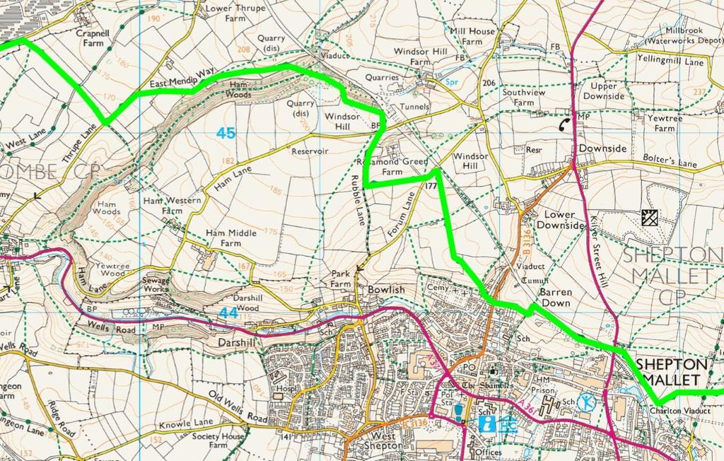
2 Wells to Shepton Mallet 6.1 miles 1. Leaving the museum behind you pass the cathedral on your left and head for the small archway straight ahead. Go through the arch into the market place and then turn immediately left through the large archway to the Bishops palace. Turn right and follow the path with the moat to your left. Follow the moat all the way around to the left until you reach the road. 2. Cross over the road and enter the woodland on Tor Hill to the right. Follow the wall on the left then go up the steps on the right. Bear left where the path forks heading uphill to the gate. Continue straight across the field and enter the woods opposite and continue on the path. Leave the woods and cross a small paddock. As the paddock widens follow the fence round to the right and through a narrow section then left across the field to the stile. 3. Turn left on the track and follow the track for 1km as it passes the golf course and enters a woodland. At the far end of the woodland the track goes through a gate then bears left up a hill. At the top of the hill turn right and follow the path straight across a field to the woods beyond. Keep to the left of the clearing where the path splits and exit the woods through the gate and continue straight across the next field keeping to the left hand side. Exit by the gate at the end and walk along the lane. 4. A short way along take the bridleway on your right and cross the field first to the left then diagonally across to the far right hand corner. As the corner narrows take the path through the gate and across the dip to the gate onto the lane. Turn left along the lane and continue straight on past the solar farm. 5. Further along the lane take the path on the right through a narrow field and into a larger field. Keep straight across the field to a stile on the far side. Cross over the lane and into the next field heading for the far left hand corner. Turn left onto the road for a short distance before taking the path on your right. Cross over diagonally left keeping the metal barn on your right until you come to a stile. Cross the next field to the far left hand corner. Continue straight across the next two fields to the double gates. Cross this field keeping the wood to your right until you come to the kissing gate on the corner of the wood. Follow the path down through the wood to the stream at the bottom. Go over the stream and turn right up a steep bank and follow the path through the quarry keeping the cliffs to your right. At the end of the cliffs go up the stone steps and turn sharp right. Turn immediately right again up the wooden steps. At the top of the steps turn left through the gate and follow the boundary of the field all the way around to the gate on the far side. 6. Turn right on the road then immediately left onto the narrow track on the left. Halfway down the track take the path off to the left through the gate and take the path past the equestrian centre. At the end of the path turn right on the farm track then immediately left on the road. A short way along the road turn right up the track then immediately right through the kissing gate and head diagonally left towards the hedge sticking out. At the end of the field go straight on through a gate and keep following the hedge on the left bearing left at the end to a stile. Cross the field diagonally right to the gate 2

3 and go left then diagonally right down the steps. Go through the gate at the bottom down the steps and left down the steep lane to a road. Cross the road and go slightly right into an alley between two houses. Go up the alley to emerge on another road beside the gates to a cemetery. 7. Again cross slightly to the right and take the footpath up some steps. At the top of the hill bear right on a path to follow the right hand hedge until you come to a building at the bottom right of the field. Turn left up the field to come to a pair of kissing gates on your right. Go through the gates and follow the path between the wall and fence. Continue along this path until the metal fence ends, keep ahead until you come to a metal stile on your right. Ignoring this stile head left to a bridge under the disused railway. Through this bridge the path goes right and leads down some steps to the A
4
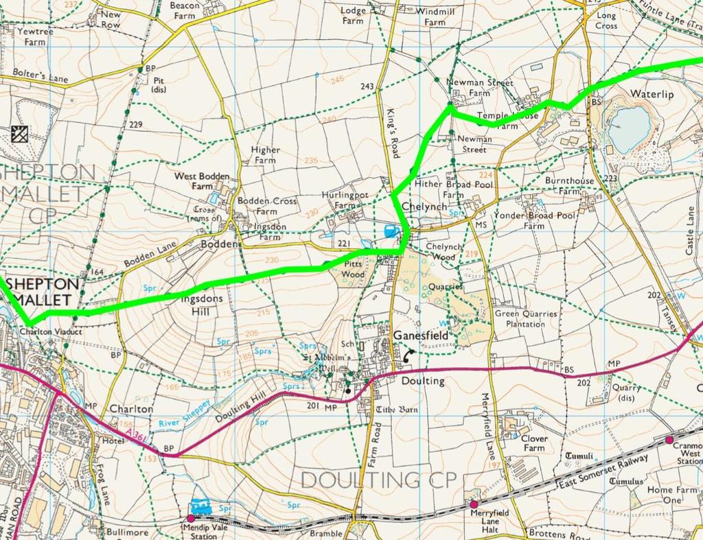
5 Shepton Mallet to Waterlip 2.6 miles 8. Go left up the A37 to the end of the pavement, then cross over to Ivy House Farm and go down the track. Go through a gate into a field and bear right to a double stile at the corner of the wall on your right. Cross this stile and continue down the field to a gate on your left. Go through the gate and continue down the hill, keeping the Somerset and Dorset railway viaduct on your right, to come to a metal post stile. Over the stile keep ahead until another metal post stile appears on your left. Turn left past this stile and climb the hill diagonally to reach a stile in the hedge opposite. Cross this stile onto a track, this track is the Foss Way, the Roman road from Exeter to Lincoln, cross the track to some steps leading to a stile. Over the stile go up the field towards a wood close to the end of the field bear left onto a small path through the top of the woods and follow this through the wood to come to a kissing gate onto a lane. Cross the lane, through the kissing gate and continue straight ahead up the hill. When you reach a small clump of trees on your right, look for a kissing gate on the right and go through to continue up the hill in front. When you reach the top look back at the views extending to Glastonbury Tor and beyond. This is Igsdons Hill. Continue ahead into a field as the route becomes a track. Where the track turns sharp left continue ahead through a kissing gate and follow the right hand hedge to come to a stile. Over the stile, continue to follow the right hand hedge towards a wood on the right and a kissing gate onto a lane. 9. Turn right on the lane and walk down passing a pond on the left and climb the slope, ignoring a crossing path, to come to Chelynch. Turn left and walk straight past the Poachers Pocket on your left, continuing straight ahead out of the village. Look out for some stone steps on your right and climb them to cross a stone stile into a field. Go half left across this field to come to a gap in the hedge with a stone stile in the top right of the field, go through and ignoring a path to the right follow the right hand hedge to come to a kissing gate - if there are crops in the field you may need to walk around the field boundary on the right rather than follow the right of way across the field. Continue across the field to another kissing gate leading onto a lane. Turn right on the lane and walk for about fifty meters to a field gate on the left. Through this gate head up the field, slightly to the right, to come to a pair of kissing gates at the top. Through the gates continue straight across the field, with a wind turbine on your left, to come to another Kissing gate. Continue across the next field to come to a stone stile onto a road. Turn left on the road for a few meters and take the lane on the right opposite Temple House Farm. Follow this lane until you come to a road. 5
6 10 9 6
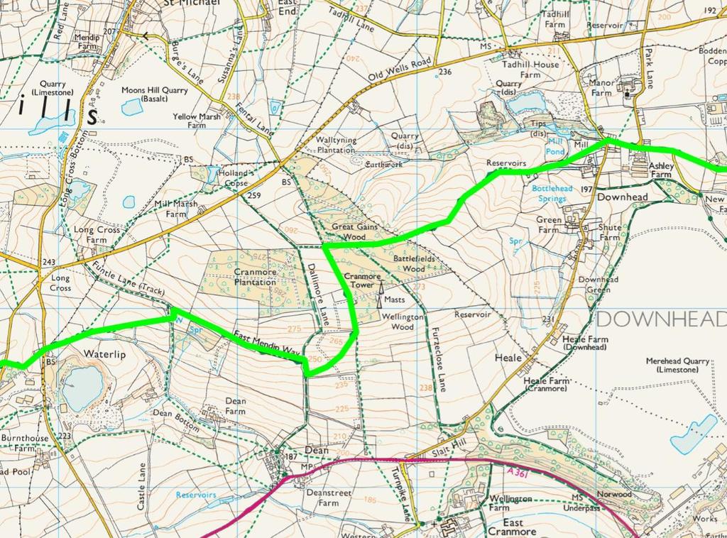
7 Waterlip to Great Elm 7.5 miles 10. Cross the Stoke St Michael road to the path opposite, to a 2 step stile with a wooden sign post. Further up the grassy track turn right through what appears to be a garden and go up the slope bearing left to reach a kissing gate. Go through the gate and cross to the field gate opposite, go through this gate and follow the path to the right, to a gate in the right hand corner. Go through this gate head right across the field, passing a corner in the hedge to come to a kissing gate in the far hedge. Go through into the woods turning left to come to another kissing gate, and go through onto Funtle Lane. Turn right through the gateway and follow the track past the house to come to a bridle gate, go through and continue straight across the field ahead. Keeping the woods to the right cross over two more stiles and continue to a gate in the corner. Looking to your left you can see the top of Cranmore Tower. Go through the gate turn right onto a track going downhill, after about 80 meters look out for a kissing gate on the left, where the path goes left and right. Turn back through this gate and climb diagonally up the hill to a kissing gate in the far right corner. Go through this gate, turn left and go over a stile into the woods around Cranmore Tower. Keep ahead following the left hand hedge, passing the tower on your right, to continue downhill. Follow the fence on the left downhill until you see a track crossing through a gate on the left and heading off to the right around a left hand turn. 11. Ignore the track and turn sharp right and continue following the signs on posts, to follow a level but narrow path across the hill. Follow this path, ignoring larger tracks to left and right until you see a kissing gate at the edge of the wood. A large tree has fallen here and appears to block the way, but go through and walk to the right and go through a kissing gate ahead and slightly the right. Follow the right hand hedge down the field. The OS map shows the path in the field to the right but this is incorrect. The path continues through a kissing gate with the hedge on the right. Cross a stile in an electric fence and continue to follow the right hand hedge. Go through a kissing gate on the right onto a track, and follow the track down to another kissing gate on the left and go through into the woods. At the end of the woods, go through another kissing gate and cross the fields ahead. Go through a kissing gate onto a lane. Go right on the lane then left onto a road. Follow this road for about 200 meters then take the minor road on the right. 12. When the road goes sharp right go ahead on a drive labelled Little Manor, Private Drive. Where the drive goes to the left, take the kissing gate on the right, signpost Frome Asham Woods. Follow the path between the hedge and a post and rail fence until a kissing gate that leads to Asham Woods. Follow the track through the woods until you come to a sign pointing to a small path to the left. Follow this path, with care as the 4x4s have created big ruts, passing an old stile, until you come to a stream. Cross the stream and bear left up the hill to another marker. Take the right hand path and follow as it undulates through the trees, to come eventually up a hill to turn right onto a track out of the woods. As the path bends left and uphill in the woods it splits and you take the left hand path straight ahead to find the track out of 7
8 the woods. At the edge of Asham Woods follow the sign onto a track and out of the woods. The OS map is incorrect, the track is the correct path. Follow the track and go through a gate onto a road. Go through two more gates to dip under the main road and carry on through a gate ahead. At the road junction go left along the road and at the next junction turn right until you come to a footpath sign on your left. Go through the gate, cross the field to the kissing gate in the opposite hedge, go through and bear left to a kissing gate in the next hedge. Go through the gate and turn right onto a track. Follow this track as it goes left and right until you come to a road. The road to the left was cut when Whatley quarry was expanded. 13. Cross the road into the woods by the signpost and through the kissing gate. Follow the quarry fence on the left and keep ahead when the fence disappears. Keep following the path as it meanders beside a stream, until you can cross to a kissing gate. Go through and across the field to a wall by a road. Turn left before the wall and cross the stream and field to another kissing gate onto a track. Turn left along the track. When you come to a fork take the left lower track, and follow the stream on the left. When you see the quarry buildings on the left, the path goes right up a long flight of steep steps. When you get to the top of the second flight go left and keep left at the path junction, passing an old steel water tank to come down to a road. 14. Turn right up the road for about 10 meters and cross to take the path up the bank. Go through the kissing gate into a field and follow the hedge to the left. Look to the right and you will see the spire of Whatley Church. Keep on through 3 kissing gates to come onto a track. Go right on the track until you come to a bridle gate on the right. Ignore this and go left to follow the hedge to come to a gate onto a road. Cross the road and go left to reach a path into the woods on the right via a kissing gate. Follow the path through the woods to a junction and take the left down the hill. Follow the path across a stream and across the railway ahead. Go right to a crossing path with steps to your left; turn right to come to the stream again. Cross the bridge and follow the path to come to a kissing gate that leads onto a road by a bridge. This is Great Elm. 8

9

10
11 Great Elm to Frome 2.6 miles 15. Cross the road and follow the permissive path beside the Mells Stream. Follow this path, keeping the river to your left as it goes round a long curve to the right and going under a rail bridge. Where you see a bridge to your left, do not cross, but keep the stream on your left. You are now back on a public footpath. Follow this path where it passes under a bridge through a gate. Ignore the signs to the left and cross the bridge ahead to now keep the stream on your right taking the right hand fork just after the bridge.. On the left are some partially restored lime kilns. Ignore the first bridge on the right but cross the second. Continue to follow the path by the stream until you come to a sign post on the left. 16. Take this path which climbs steeply to a stile into a field. Cross the field to a stile opposite onto a road go straight across to a track leading up through a field. Where the track bears left keep going straight on up the hill on the path to a gate. Go through the gate and straight ahead up the hill, past houses on the right, and eventually come to a road. 17. You are now on the outskirts of Frome. Cross the road on the left in front of the mini roundabout turn right then left down Whatcombe Road. Cross over to take Upper Whatcombe on the right. When you come to the bottom of some steps on your right, turn right onto a footpath which curves up to the left. Follow this footpath into a lane between houses, passing a sign showing it unsuitable for vehicles, to come to Goulds Ground behind Trinity Church. Follow on to Trinity Row, and continue along York Street to reach Selwood Road. Go left onto Selwood Road then right into Trinity Street. Take the second right into Castle Street and look for a set of steps on your left. Go down the steps and walk ahead to Catherine Street. 18. Turn left into Catherine Street and follow down the hill until it becomes Catherine Hill, where the cobbles start. Go down Catherine Hill and then left into Stony Street to arrive at Frome Market Place. Go left into Cork Street, cross the crossing and go right around the National Westminster Bank to pass the George and continue along past the shops to come to the Bridge over the river Frome. This bridge is almost unique in having houses built on it. Cross the bridge and take the first left towards the Market Yard Car Park. Go into the car park and head for the Cheese and Grain hall to the right. 19. This is the end of the Mendip way, and you can enjoy a well-earned drink in the Cheese and Grain café. 11

12
Danbury Words and pictures by Laurie Page of the Public Rights of Way team at Essex County Council.
 Danbury Words and pictures by Laurie Page of the Public Rights of Way team at Essex County Council. An undulating walk from Danbury village to the bluebells at the National Trust property of Blakes Wood.
Route: Skewsby Foulrice Stearsby
 Route: Skewsby Foulrice Stearsby Distance: 7 miles Map: Explorer: 300 Howardian Hills & Malton Start (OS ref): SE625710 Park in the village of Skewsby. Walk east out of the village to the T-Junction and
Husthwaite to Byland Abbey
 Husthwaite to Byland Abbey This walk begins with a loop round the village of Husthwaite and continues towards Coxwold along a disused railway line, which is now a right of way. It passes through Coxwold
The Hundred Parishes
 The Hundred Parishes Walks from railway stations number 9 6.4 miles (10kms) from Bishop s Stortford to Stansted Mountfitchet Start: Bishop s Stortford station (Grid Reference TL492209) (ample parking and
Bakewell Club Site - Robin Hood's Stride
 Bakewell Club Site - Robin Hood's Stride Camping and Caravanning Route Summary A circular walk with fabulous views winding it's way through the beautiful White Peak scenery. Points of interest include
Redesdale Arms. A Trio of Walks
 Redesdale Arms A Trio of Walks Welcome to The Redesdale Arms Hotel The award winning 34 bedroom Redesdale Arms Hotel sits at the gateway to the Cotswolds in the High Street of the historic town of Moreton-in-Marsh.
LDWA SOUTH DOWNS MARATHON
 AHD ahead SDW South Downs Way BL/BR bear left/bear right TL/TR turn left/turn right SP signpost/fingerpost X cross LEG 1 - EAST DEAN to WP1 NORTON GR 470019. Open 1030 to 1300. 9.6 miles. 1.1 From village
LDWA SOUTH DOWNS MARATHON 13 th MAY 2018
 AHD ahead SDW South Downs Way BL/BR bear left/bear right TL/TR turn left/turn right X cross LEG 1 - EAST DEAN to WP1 NORTON GR 470019. Open 1030 to 1300. 9.7 miles. 1.1 From village hall TL and walk to
HARDMOORS 26.2 WHITE HORSE HALF ROUTE DESCRIPTION - 018
 HARDMOORS 26.2 WHITE HORSE HALF ROUTE DESCRIPTION - 018 Follow Cleveland Way, keeping to the left hand path (right path is a bike trail) Ignoring any turnings to the left or right At path junction (after
THE PONTON PLOD - 27 MILE ROUTE
 THE PONTON PLOD - 27 MILE ROUTE Emergency Phone Number 07771 813514 Abbreviations: BW Bridleway X Cross immd immediately FP Footpath TL Turn left L Left thro through KG Kissing Gate TR Turn right R Right
WETHERBY CIRCULAR by Tania Dickinson
 WETHERBY CIRCULAR by Tania Dickinson This walk in lower Wharfedale includes a disused railway line at the beginning and riverside at the end, with parkland, fields, woodland and villages in between. Distance
Walk Description. Directions
 Title: Saffron Trail: Battlesbridge to Chelmsford Distance: 14¾ miles Time taken: 6 hours Start Point: Outside the Barge Inn, Battlesbridge OS Explorer Map: 175 & 183 Grid Ref.: TQ 780 947 Transport: Rail:-
RILLINGTON TO MALTON by Tania Dickinson
 RILLINGTON TO MALTON by Tania Dickinson This walk takes you from the Vale of Pickering up on to the Wold scarp, before dropping down again through the pretty village of Settrington and joining the Centenary
BALCOMBE AND ARDINGLY RESERVOIR, WEST SUSSEX
 BALCOMBE AND ARDINGLY RESERVOIR, WEST SUSSEX 7 miles Circular 4 hours 080816 Challenging Terrain Hi, I'm Luke and this is my West Sussex Weekends walk It's a 7 mile loop from Balcombe rail station, taking
Green Man Ultra Route Directions 2018
 Green Man Ultra Route Directions 2018 Start-CP1 (9 miles) Community Forest Path (CFP) Frome Valley Way (FVW) From the starting line cross the playing fields diagonally to the metal gates in the hedge lined
NEWLANDS CORNER AND ST MARTHAS
 NEWLANDS CORNER AND ST MARTHAS 10k CIRCULAR ROUTE 2½-3HRS GU4 8SE From Newlands Corner on the North Downs just outside Guildford, you can enjoy one of the most beautiful panoramas of quintessential English
Follow the Lantern Way clockwise from Dursley Town Hall through Cam & Coaley to Uley and back to Dursley (about 14 miles)
") According to the Rev Kilvert's diary of 1873, couples on their way to evening services in winter followed a practical though unusual local tradition: "My Mother says that at Dursley, when ladies and gentlemen
According to the Rev Kilvert's diary of 1873, couples on their way to evening services in winter followed a practical though unusual local tradition: "My Mother says that at Dursley, when ladies and gentlemen
Beautiful Walks from the Blue Ball Inn
 Walk No. 7 COAST AND VALLEY WALK Countisbury, Glenthorne, County Gate, Brendon, Rockford and Wilsham 10 MILES APPROX. Walking time 5 hours approx. (not including breaks)> OS Sheet 64/74 Lynton and Lynmouth.
Hammer Vale and Linchmere Common
 point your feet on a new path Hammer Vale and Linchmere Common Distance: 9 km=5½ miles or 6 km=3¾ miles easy walking with one steep section Region: Hampshire, West Sussex Author: Botafuego Refreshments:
Welsh Newton and Woodland
 Welsh Newton and Woodland This is a 8.2km miles (approx) walk which will take about 2.5 hours at a relaxed and leisurely pace. There are a few hills but no steep inclines. Start at Llangrove bus stop and
8 Miles Circular 4 hours
 VISIT RYEDALE HELMSLEY AND RICCAL DALE 8 Miles Circular 4 hours 090616 Challenging Terrain An 8 mile (13km) circular walk from the market town of Helmsley in Ryedale. The route heads out across sheep pastures
Dyrham and Hinton Parish Walks
 Dyrham and Hinton Parish Walks A series of five walks in the parish, exploring most of the public footpaths. By John Miller Each walk is described in detail, with a complete map, to provide a handy guide
This walk description is from happyhiker.co.uk
 This walk description is from happyhiker.co.uk Pendle Hill Walk From Barley Starting point and OS Grid reference Ordnance Survey map Distance Traffic light rating Barley village honesty box car park OS
Masson Hill. Walk. Approximately 4 km. Moderate Walk Begins from Matlock Railway Station
 Masson Hill Walk Approximately 4 km Moderate Walk Begins from Matlock Railway Station TOWN WALKS Masson Hill walk is approx. 4 km. It can be walked in a couple of hours or so. Enjoy your walk and the beautiful
Hascombe and Winkworth Arboretum Downs Link Path, Smithbrook Kilns
 point your feet on a new path Hascombe and Winkworth Arboretum Downs Link Path, Smithbrook Kilns Distance: 18 km=11 miles Region: Surrey Author: RDC easy walking Date written: 7-may-2016 Last update: 30-aug-2018
Harlington - Sharpenhoe - Pulloxhill
 Harlington - Sharpenhoe - Pulloxhill ID: 3676, Distance: 8 miles, Height gain: 140 Metres, Map: Explorer 193 Luton & Stevenage, Contributor: Dennis Jeanes Duration: 3 Hours 27 Mins Features Church,Great
NETTLESTEAD & YALDING
 NETTLESTEAD & YALDING ULL CIRCUIT - Sheet 1 (first and last sections) Open fields (see 'Introductory Notes') 88 Direction label (as in the walk notes) ROADS: 81 10m Significant roads Redhill arm North
Bonnie Prince Charlie Walk
 Bonnie Prince Charlie Walk A waymarked route from Ashbourne to Derby to celebrate the 60th anniversary (1995) of the formation of the Ramblers' Association. This route follows the general direction of
THE WELLDIGGERS ARMS, HESWORTH AND FITTLEWORTH TRAIL
 THE WELLDIGGERS ARMS, HESWORTH AND FITTLEWORTH TRAIL 5.5 miles Circular 3 hours 041017 Challenging Terrain A 300-year-old pub turned country-inn on the edge of the South Downs National Park, The Welldiggers
LOCAL CIRCUIT EM1: EAST MALLING & BARMING HEATH. N 2m ROADS: Significant roads PATHS: Starting direction Barming Longsole Mission Church
 Ditton Church Scott Close LOCAL CIRCUIT EM1: EAST MALLING & BARMING HEATH 6 Community Centre F Open fields (see 'Introductory Notes') 1m 88 Direction label (as in the walk notes) East Malling Church -
Approximate distance: 10 miles For this walk we ve included OS grid references should you wish to use them. Start. End
 Approximate distance: 10 miles For this walk we ve included OS grid references should you wish to use them. 2 3 Start End 1 N W E S Reproduced by permission of Ordnance Survey on behalf of HMSO. Crown
Dorridge & District Residents Association A Walk Along The Green Belt From Dorridge to Catherine-de-Barnes
 Dorridge & District Residents Association A Walk Along The Green Belt From Dorridge to Carine-de-Barnes The starting section of this walk through open fields would be destroyed by building of motorway
For more information and to buy this book click here ISBN: CICERONE. Guides for walkers, trekkers, mountaineers, climbers and cyclists
 For more information and to buy this book click here ISBN: 9781852845377 CICERONE Guides for walkers, trekkers, mountaineers, climbers and cyclists www.cicerone.co.uk WALK 5 Ouston and Urpeth Distance
The North Pennines from near Langwathby
 3.6 Langwathby to Armathwaite Map panel?? Distance 12.7 miles (20.5 km) Terrain farm, woodland and riverside paths; some potentially muddy tracks; a few short sections of road Grade gently undulating Food
Tideswell to Castleton
 Tideswell to Castleton 1 Walk summary Length: 14 km, 8.5 miles Maps: OS Explorer OL1 The Peak District - Dark Peak Area, OS Explorer OL24 The Peak District - White Peak Area, OS Landranger 110 Sheffield
Bagshot Heath and Swinley Forest
 point your feet on a new path Bagshot Heath and Swinley Forest Distance: 13 km=8 miles Region: Berkshire, Surrey Author: Botafuego Refreshments: Forest Look Out, Bagshot easy walking Date written: 17-feb-2013
Approximate distance: 5.5 miles For this walk we ve included OS grid references should you wish to use them. Start. End
 Approximate distance: 5.5 miles For this walk we ve included OS grid references should you wish to use them. End 4 1 Start 3 2 N W E S Reproduced by permission of Ordnance Survey on behalf of HMSO. Crown
TOCKENHAM. Walks for Healthy Living. The Countryside Code (October 2016) Respect other people:
 Respect other people:") The Countryside Code (October 2016) TOCKENHAM Respect other people: consider the local community and other people enjoying the outdoors leave gates and property as you find them and follow paths unless
The Countryside Code (October 2016) TOCKENHAM Respect other people: consider the local community and other people enjoying the outdoors leave gates and property as you find them and follow paths unless
9.5 km Circular 3 hours
 RANMORE CIRCULAR A 6 mile (9.5km) circular walk from Boxhill and Westhumble Station in the village of Westhumble, passing through part of the Polesden Lacey Estate, Ranmore Common and Denbies Vineyard.
Walk 7: Watchet to washford
 Walk 7: Watchet to washford Length: Moderate - 7.5 miles / 12 km Good For: Theme: History Duration: 2-3 hours depending on speed of walking Notes: This is a moderate to difficult walk in places, with steps,
Walks Around Bishopstone & Hinton Parva
 The Walks: From ½ mile ambles to 8 mile scenic loops Hinton Parva Walks H1 H2 H3 Bishopstone Walks B1 B2 B3 B4 B5 Walk B1: Bishopstone Village, The Dingle (stream) & Pond A short circular village amble
Distance: 14 km=8½ miles or 7 km=4½ miles easy-to-moderate walking
 point your feet on a new path Normandy Distance: 14 km=8½ miles or 7 km=4½ miles easy-to-moderate walking Region: Surrey Author: Botafuego Refreshments: Pirbright, Ash date written: 20-feb-2012 date revised:
Distance: 5 km=3 miles or 4½ km=2¾ miles or 3½ km=2 miles
 point your feet on a new path Vann Lake Distance: 5 km=3 miles or 4½ km=2¾ miles or 3½ km=2 miles Region: Surrey Author: Schwebefuss Refreshments: Ockley easy walking Date written: 12-feb-2011 Date revised:
Distance: 9½ km=5¾ miles moderate walking or two walks of 4¼ km=2¾ miles and 6½ km=4 miles
 point your feet on a new path White Hill, Headley Distance: 9½ km=5¾ miles moderate walking or two walks of 4¼ km=2¾ miles and 6½ km=4 miles Region: Surrey Author: Fusszweig Refreshments: Headley Date
THE DOG AND DUCK HAREWOODS ESTATE TRAIL. 6 Miles Circular 3 hours. Getting there. Walk Sections
 THE DOG AND DUCK HAREWOODS ESTATE TRAIL Moderate Terrain A 6 mile circular pub walk from the Dog and Duck in Outwood, Surrey. The Dog and Duck is a delightful pub where everyone is made welcome. From walkers
How to get there. Respect - Protect - Enjoy
 How to get there Driving: Postcode is RG9 5PF and there is a car park just across from the pub. Nearest station: Henley-on-Thames station is 5.6 miles away. We re delighted to present three circular walks
No. 1 By River Ribble & Brungerley Park 3¼ Miles,
 RVRNEWS 102 No. 1 By River Ribble & Brungerley Park 3¼ Miles, Approx 2 Hours This walk starts at the gate on platform 2 of Clitheroe station. Leaving the station turn left making towards Kirkmoor Rd and
CHINTHURST HILL AND THE GRANTLEY ARMS, SURREY
 CHINTHURST HILL AND THE GRANTLEY ARMS, SURREY 4 miles Circular 2 hours 110417 Challenging Terrain A 4 mile (can be shortened to 3 miles) circular pub walk near Wonersh in Surrey. The walk begins with an
Walk 2: doniford to east quantoxhead
 Walk 2: doniford to east quantoxhead Length: 9 ¼ miles / 15km Good For: Difficulty: Moderate Theme: Nature Notes: This walk is tidal - please check tide times before setting off. Dogs are welcome but need
Shepherdswell - Dover
 Shepherdswell - Dover The North Downs Way > Shepherdswell to Dover Introduction This part of the path is slightly different in character from most other parts of the path since it spends much of the time
Weatherman Walking. Approximate distance: 5.5 miles For this walk we ve included OS grid references should you wish to use them. Start.
 Approximate distance: 5.5 miles For this walk we ve included OS grid references should you wish to use them. 4 1 Start End 3 2 N W E S Reproduced by permission of Ordnance Survey on behalf of HMSO. Crown
Winterfold Wood. point your feet on a new path. In Brief
 point your feet on a new path Winterfold Wood Distance: 8½ km=5¼ miles Region: Surrey Author: Schwebefuss Refreshments: Windmill Inn, Peaslake after the walk moderate walking with many gradients Date written:
There are toilets at Manningtree Station, Flatford (close to the hump back bridge) and in Dedham.
 and in Dedham.") Arriving by Train Main Features of the Walk Outline Route Employs particularly attractive paths, many of which offer impressive views across Dedham Vale. Includes a section along the tidal section of the
Arriving by Train Main Features of the Walk Outline Route Employs particularly attractive paths, many of which offer impressive views across Dedham Vale. Includes a section along the tidal section of the
Although the majority of these walks are around country lanes you should still follow the Country Code:-
 With the update of the Parish Plan was a request for details of any Walks around Pillaton The following pages give several walks that I and my wife have done for many years. Please be aware that NONE OF
Oldbury & Littleton, South Gloucestershire
 Oldbury & Littleton, South Gloucestershire Starts at Church Lane, Oldbury. BS35 1QF 2 hours 0 minutes 5.2miles 8.4km Easy ID: 0.2468 Developed by: GEOFF MULLETT Checked by: Marion Stone www.ramblersroutes.org
Sweetwater and the Holy Well Witley Station, Hambledon, Chiddingfold
 point your feet on a new path Sweetwater and the Holy Well Witley Station, Hambledon, Chiddingfold Distance: 7½ km= miles Region: Surrey Author: Schwebefuss Refreshments: Hambledon, Chiddingfold easy walking
A mainly flat walk along the Peak Forest Canal to Castle Hill and returning along the River Tame via Hulmes Wood and Haughton Dale.
 Walk 9 Haughton Green, Peak Forest Canal, Castle Hill, Hulmes Wood, River Tame, Haughton Dale Circular Miles: 3.9 Time: 1 Hour 30 Minutes Grade: Easy To Moderate Starting Point: Junction Of Gibraltar Lane/Newport
Lincolnshire Walks. Grainthorpe. Three circular walks of 2 ¾, 9 and 9 ½ km (1 ¾, 5 ½ and 6 miles)
") Lincolnshire Walks Grainthorpe Three circular walks of ¾, 9 and 9 ½ km (1 ¾, ½ and 6 miles) Introduction Explore the coastal marshes, arable hinterland, Louth Navigation canal and the village of Grainthorpe
Lincolnshire Walks Grainthorpe Three circular walks of ¾, 9 and 9 ½ km (1 ¾, ½ and 6 miles) Introduction Explore the coastal marshes, arable hinterland, Louth Navigation canal and the village of Grainthorpe
Walk Description. Directions
 Title: East Hanningfield Distance: 8 miles / 9 miles Time taken: 3-3½ hours Location: 5 miles south east of Chelmsford Parking: Free car park off The Tye, East Hanningfield, next to the primary school
9.5 km Circular 3 hours
 MEDIEVAL WAVERLEY Challenging Terrain A 6 mile (9.5km) undulating circular walk from Tilford village passing close to The Sands village and the historic ruins of Waverley Abbey. From the top of Crooksbury
Uif!Sfe!Mjpn-!Mpnhepn! bne!dbnnpdl!dibtf-! Tubggpsetijsf
 Uif!Sfe!Mjpn-!Mpnhepn! bne!dbnnpdl!dibtf-! Tubggpsetijsf 7/6!njmft! Djsdvmbs!!!!!!! 4!up!4/6! ipvst Strenuous Terrain Uif!Sfe!Mjpn!jt!b!dmbttjd!wjmmbhf!qvc-!b! hsfbu!qmbdf!up!tbujtgz!zpvs!ivnhfs!bgufs!b!
The main feature of this tranquil walk is a visit to the source of the Thames (the Thames head) which is in a field just 3 km from Kemble station
 which is in a field just 3 km from Kemble station") SWC Walk DRAFT Kemble circular: the source of the River Thames. The main feature of this tranquil walk is a visit to the source of the Thames (the Thames head) which is in a field just 3 km from Kemble
SWC Walk DRAFT Kemble circular: the source of the River Thames. The main feature of this tranquil walk is a visit to the source of the Thames (the Thames head) which is in a field just 3 km from Kemble
Sutton Valence or Harrietsham to Pluckley
 Sutton Valence start last checked Harrietsham start last checked Rest of walk last checked 22 April 2018 30 March 2017 3 June 2017 Document last updated: 2 May 2018 This document and information herein
Distance: 11 km=7 miles or 8 km=5 miles easy walking with two short steepish sections
 point your feet on a new path Common Distance: km=7 miles or 8 km=5 miles easy walking with two short steepish sections Region: Surrey Author: Schwebefuss Refreshments: Chart, Moorhouse Date written: 7-dec-05
Effingham to Westhumble
 Main walk morning last checked Main walk afternoon last checked Pub diversion last checked Westhumble Circular last checked 12 December 2017 23 December 2017 19 August 2015 27 October 2017 Document last
Walk 2 Village Hall - The Shippy - Woodhouse Farm - Village Hall
 Walk 2 Village Hall - The Shippy - Woodhouse Farm - Village Hall The walk is approximately 4km (2.5 miles) across fairly flat countryside with about a quarter on country lanes. It should take about 1 hour
Hever to Ashurst walk
 Saturday Walkers Club www.walkingclub.org.uk Hever to Ashurst walk A surprisingly remote part of the High Weald on the Kent/East Sussex border Length OS Maps Toughness Features Walk Options Main Walk:
Outwood: oaks, buttercups and windmill
 point your feet on a new path Outwood: oaks, buttercups and windmill Distance: 9 km=5½ miles Region: Surrey Author: Schwebefuss Refreshments: Outwood easy walking Date written: 23-may-2014 Last update:
Walking Pembrokeshire.
 Walking Pembrokeshire Canaston Woods Walk It s good to walk, so why not step out and sample some of the walks your neighbourhood has to offer. This pleasant and interesting walk which starts and finishes
THE BECK STONE Backstone Beck on Ilkley Moor
 THE BECK STONE Backstone Beck on Ilkley Moor 1 Three different routes which take in the best of the lower slopes of Ilkley Moor, with bracken, heather, a tarn (a small mountain lake) and rushing streams.
North Downs Way Monster Alternative North Downs Way Double Walk Box Hill or Dorking to Newlands Corner or Guildford
 point your feet on a new path North Downs Way Monster Alternative North Downs Way Double Walk Box Hill or Dorking to Newlands Corner or Guildford Distance: 0 or 6 km=8½ or 6 miles (by rail) or 6 km=½ miles
Ambergate & Betty Kenny's Tree.
 Walk Information Walk Area: Ambergate OS Map: Explorer OL24 Distance: 4 Miles White Peak Area Start Point: Holly Lane, Ambergate 1:25000 Map Ref: SK 346 254 Post Code N/A General Information Altitude Data
Rhossili - Tears Point - Mewslade Bay - Talgarth's Well - Rhossili - ID: 148. Walk description:
 Walk description: A glorious walk combining thrilling cliffs with beautiful wild beaches and a bird's-eye view of the Gower peninsula from Rhossili Down. The adventurous can walk out to the Worm's Head
Chipstead to Kingswood walk
 Saturday Walkers Club www.walkingclub.org.uk Chipstead to Kingswood walk Ancient woodland, open downs and farmland in London's Green Belt Length OS Map Toughness Features Main Walk: 15½ km (9.6 miles).
Slindon Folly - South Downs, West Sussex
 Slindon Folly - South Downs, West Sussex Starts at Park road-side near entrance to Slindon College 2 hours 15 minutes 4.5miles 7.2km Easy ID: 0.1598 Developed by: Chris Mumford Checked by: Rockpit www.ramblersroutes.org
ST. AGNES. you cannot put a time limit on beauty.
 ST. AGNES CIRCULAR WALKS AROUND There are many enjoyable and picturesque walks around St. Agnes most are signposted and are featured on the St. Agnes Mini-guide map. Because most of our footpaths are in
Staplehurst to Headcorn or Cranbrook
 Staplehurst to Cranbrook last checked Frittenden to Bubhurst last checked Goudhurst ending last checked Sissinghurst village to Headcorn checked 12 May 2018 14 April 2014 1 April 2017 12 July 2017 Document
TIMEBALL and TELEGRAPH TRAIL
 TIMEBALL and TELEGRAPH TRAIL A 97 mile walk between Deal & Greenwich Prominent on Deal seafront is a tall building with a large black ball on the roof. This is the Timeball Tower. The current building
Horsted Keynes to Sheffield Park Hop On The Bluebell Line
 point your feet on a new path to Sheffield Park Hop On The Bluebell Line Distance 11½ km=7 miles Region: West Sussex, East Sussex Author: Hautboy easy walking with a steam train ride Refreshments: The
Waterhead Pier to Orrest Head, Windermere and Bowness
 Waterhead Pier to Orrest Head, Windermere and Bowness A 4 1 2 hour walk through Woodlands and the Troutbeck Valley with spectacular Lake and Mountain views and a lakeshore path. Walk 10 Walk 11 Walk 12
A Walk around Holmes Chapel starting & finishing at Holmes Chapel Railway Station. by Tony & Lindsay Wright (2016)
") A Walk around Holmes Chapel starting & finishing at Holmes Chapel Railway Station. by Tony & Lindsay Wright (2016) Introduction Holmes Chapel Railway Station is on the Crewe to Manchester line. The station
A Walk around Holmes Chapel starting & finishing at Holmes Chapel Railway Station. by Tony & Lindsay Wright (2016) Introduction Holmes Chapel Railway Station is on the Crewe to Manchester line. The station
West Marden and Stansted Forest
 point your feet on a new path West Marden and Forest Distance: 3½ km=8½ miles easy walking with optional ½ km=½ miles extension to Rowlands Region: West Sussex Author: Hautboy Refreshments: West Marden,
EAST GRINSTEAD AND THE HIGH WEALD, WEST SUSSEX
 EAST GRINSTEAD AND THE HIGH WEALD, WEST SUSSEX 7 miles Circular 3.5 hours 301015 Challenging Terrain Hi, I'm Tom and this is my West Sussex Weekends walk. I live and work in London but often head out of
Shipbourne, Dene Park and Oxon Hoath
 point your feet on a new path Shipbourne, Dene Park and Oxon Hoath Distance: 1½ km=8½ miles or 9½ km=6 miles Region: Kent Author: Malinovka Refreshments:, Shipbourne Map: Explorer 147 (Sevenoaks) & 148
10 Miles Circular 5 hours
 VISIT RYEDALE PICKERING AND CAWTHORN CAMPS 10 Miles Circular 5 hours Moderate Terrain 120616 A 10 mile (16km) there and back walk from the market town of Pickering in Ryedale. The route heads north through
More Walks around Gayton
 Illustrated book of More Walks around Gayton Northamptonshire PRICE 1.50 All proceeds to Gayton Church Heritage Trust More Walks around Gayton Foreword This little book is a sequel to Walks around Gayton,
A circular walk of or km (2 1 4 or miles)
") Grantham A circular walk of 3 3 4 or 5 3 4 km (2 1 4 or 3 1 2 miles) Introduction This relatively short circular walk, which starts in the middle of Grantham, offers plenty of variety. The route takes
Grantham A circular walk of 3 3 4 or 5 3 4 km (2 1 4 or 3 1 2 miles) Introduction This relatively short circular walk, which starts in the middle of Grantham, offers plenty of variety. The route takes
5 Miles Circular 2.5 hours
 VISIT RYEDALE KIRKBYMOORSIDE AND ST GREGORY S MINSTER Challenging Terrain A 5 mile (8 km) circular walk from the market town of Kirkbymoorside in Ryedale. The route heads west through open fields and pastures,
Banstead: Village and Woods
 point your feet on a new path : Village and s Distance: 10 km=6 miles Region: Surrey Author: Fusszweig Refreshments:, The Ramblers Rest easy walking Date written: 2-apr-2014 Last update: 11-apr-2017 Map:
SUMMER WALK 10. The Chairmakers, Worlds End
 SUMMER WALK 10 The Chairmakers, Worlds End Tuesday 10 th June 7.30pm This is a very short walk made so due to the majority of the footpaths in the area around the Chairmakers being overrun with high nettles
Country town, fields, woodland, villages, views, arrival by Underground
 point your feet on a new path Chesham Distance: 9 km= miles or 5 km=9½ miles or km=7 miles Region: Chilterns Author: Phegophilos Refreshments: Lee Common, Hyde Heath, Chesham easy walking Date written:
Pilgrims Way and Mole Villages
 point your feet on a new path Pilgrims Way and Mole Villages Distance: 20 km=12½ miles moderate walking with long easy stretches Region: Surrey Author: Schwebefuss Refreshments:, Skimmington Date written:
Puttenham and the Welcome Woods
 point your feet on a new path and the Welcome Woods Distance: 15 km=9 miles easy walking or 2 shorter walks of 5½ km=3 miles and 12½ km=7½ miles Region: Surrey Author: Schwebefuss Refreshments: or picnic
Walk 2: Beamsley Beacon and Bolton Abbey
 Walk 2: Beamsley Beacon and Bolton Abbey Start and Finish: The Memorial Hall, Main Street, Addingham, LS29 0LZ, SE 079 497 The shortest walk is about 5½ miles (8.8km) The medium Walk is about 8¼ miles
Hindleap and Vachery Ashdown Forest, Chelwood Gate, Forest Row
 point your feet on a new path Hindleap and Vachery Ashdown Forest, Chelwood Gate, Forest Row Distance: 5 km=9½ miles Region: East Sussex Author: Stivaletti Refreshments: Chelwood Gate, Forest Row Map:
Ashdown Forest, Fairwarp Rock Wood and Purple Heather
 point your feet on a new path Ashdown Forest, Fairwarp Rock Wood and Purple Heather Distance: 14 km=9 miles or 2 walks of 10 km=6 miles and 8 km=5 miles moderate walking Region: East Sussex Author: Stivaletti
Discover Shropshire. Walks and Strolls around Bridgnorth
 Discover Shropshire Walks and Strolls around Bridgnorth An Introduction to Bridgnorth Bridgnorth is made up of two towns; the High Town and the Low Town. The Low Town was once a thriving port along the
Uif!Cmbdl!Kvh!bne! Wbsnibn!Qbsl-!Ipstibn-! Wftu!Tvttfy
 Uif!Cmbdl!Kvh!bne! Wbsnibn!Qbsl-!Ipstibn-! Wftu!Tvttfy 7/6!njmft! Djsdvmbs!!!! 3/6!up!4! ipvst 200114 Moderate Terrain Uif!Cmbdl!Kvh!jt!b!hsfbu!upxn!qvc!dfnusfe! bspvne!b!mbshf!cbs!xjui!xppefn!qbnfmmjnh-!
Thornton le Dale Walks
 Thornton le Dale Walks A collection of circular walks in, and around, the village www.visitthorntonledale.co.uk Thornton-le-Dale Traders Forum and Thornton le Dale Parish Council 1 Thornton le Dale Circular
Hexham Abbey to the Racecourse Road
 Hexham Abbey to the Racecourse Road The Yarridge Road, or Racecourse Road as it is often known, runs along the ridge line to the south of Hexham and provides wonderful views of the river valley and fells