Bobbin Head Loop. 166m. 0m Ku-ring-gai Chase National Park. 5 hrs 12.9 km Circuit. Hard track 619m
|
|
|
- Augustus Bryan
- 5 years ago
- Views:
Transcription


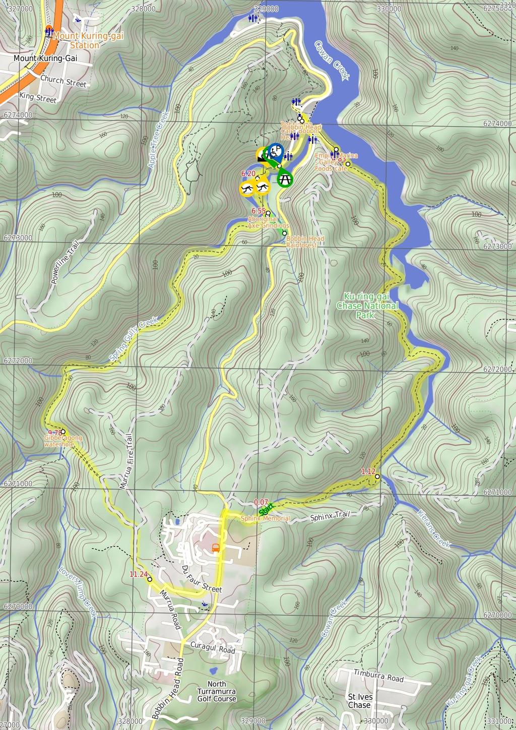
1 Bobbin Head Loop 5 hrs 12.9 km Circuit Hard track 619m This great circuit walk enjoys a variety of landscapes in Ku-ring-gai Chase National Park. The walk starts at the historic Sphinx war memorial and follows a series of popular walking tracks that loop around Bobbin Head, including historic Aboriginal engravings, temperate rainforest and a lookout. As the track passes through Bobbin Head, it provides a great opportunity to take a break and pick up a snack at the kiosk before continuing on the return leg. 4 Maps, text & images are copyright wildwalks.com Thanks to OSM, NASA and others for data used to generate some map layers. 0m Ku-ring-gai Chase National Park 166m

2 Sphinx Memorial Private Shirley spent one and a half years carving this monument whilst a patient of the Lady Davidson Convalescent Hospital. William Shirley was in hospital, being treated after serving in WW1. Shirley died in 1929, leaving this memorial to fallen A.I.F. comrades. "To my glorious comrades of the A.I.F by the late W. Shirley No 5756 Pte. 13th Battalion Died 27th August 1928" More info. Empire Marina - Galley Foods cafe Empire Marina, in Ku-Ring-Gai Chase National Park, provides facilities and services for people on boats and on foot. The marina is home to "Galley Foods" kiosk and restaurant. The kiosk provides a variety of food priced between $4-$16, and is open from 8:30am to 5pm seven days. The restaurant requires reservations, and is open for lunch Thurs-Mon, breakfast on the weekend, and in dinner on Fridays and Saturdays in summer. Phone More info. Bobbin Head Bobbin Head is a historic recreation area which is still popular today, suiting the needs of many people. At the center of the Bobbin Head area is the old "Bobbin Inn", built in the 1930s - it is now the park information center and cafe. The area is popular with picnickers, boaters, walkers, canoeists, family groups and people who like to fish. Bobbin Head is roughly divided into three sections (north, south and east). Southern Bobbin Head is a popular picnic area for families and large groups. The area is surrounded by a car park and dotted with picnic tables, electric BBQs, shelters and a large playground. There are toilets nearby, and 'The Station' is a sheltered accessible area with BBQ and tables that can be booked NPWS. The northern Bobbin Head (Orchard Park) area is a more formal picnic area. There is a large picnic shelter, surrounded by 14 smaller octagonal shelters, each of these divided into 4 walled-off compartments, ideal for small groups. The eastern side of Bobbin head is dominated by the Empire Marina and public wharf. The marina is home to a nice restaurant and public toilets. Bobbin Inn Cafe At the centre of Bobbin Head picnic area, in the old 'Bobbin Inn' building, is a cafe offering inside and outdoor dining, and a range of foods and drinks. Food includes fish and chips, wraps, focaccia, sandwiches and snack foods. Tea, coffee and cold drinks are also on offer. Opening hours are 9-4pm Mon to Fri (closed Tuesdays) & 9-5pm weekends. For more information, phone the cafe on The NPWS Bobbin Head Information Centre is open 7 days a week (closed Christmas Day) 10-4pm (closed 12-12:30pm lunch). Ramp access available via on the southwestern corner of the building. Ramp access to the information centre through the cafe. Before You walk Bushwalking is fun and a wonderful way to enjoy our natural places. Sometimes things go bad, with a bit of planning you can increase your chance of having an ejoyable and safer walk. Before setting off on your walk check 1) Weather Forecast (BOM Metropolitan District) 2) Fire Dangers (Greater Sydney Region) 3) Park Alerts (Ku-ring-gai Chase National Park) 4) Research the walk to check your party has the skills, fitness and equipment required 5) Agree to stay as a group and not leave anyone to walk solo Think before you TREK The 'Think before you TREK' program developed by NSW Police & NPWS promotes the benefits of planning ahead for your bushwalking trip by using an easy to remember acronym: T R E K Take adequate supplies of food, water, navigation and first aid equipment. Register your planned route and tell friends and family when you expect to return. Emergency beacon (PLB's) should be carried on walks with significant gaps in mobile coverage (check terrain profile). Keep to your planned route and follow the map and walking trails. Topo Maps The maps provided on wildwalks are helpful, but there are times where you may need maps covering a broader area. Maps that cover this walk include; 1: Map Series:91304S HORNSBY 1: Map Series:CMA Ku-ring-gai Chase National Park Tourist Map 1: Map Series:9130 SYDNEY Grade This walk has been graded using the AS The overall grade of the walk is dertermined by the highest classification along the whole track. 4 Length Time Quality of track Grade 4/6 Hard track 12.9 km Circuit 5 hrs Rough track, where fallen trees and other obstacles are likely (4/6) Signs Directional signs along the way (3/6) Experience Required Weather Infrastructure Some bushwalking experience recommended (3/6) Storms may impact on navigation and safety (3/6) Limited facilities, not all cliffs are fenced (3/6)
3 Are you ready to have fun? Please ensure you and your group are well prepared and equipped for all possible hazards and delays. Check park closures, weather information and Fire Danger Rating before setting out. Optional side trips and alternate routes noted are not included in this walks overall grade, length or time estimate. Please allow extra time for resting and exploring areas of interest. The authors, staff and owners of wildwalks take care in preparing this information but will not accept responsibility for any inconvenience, loss or injury you may experience. Please take care, have fun - Happy Walking. Getting there You can get to Sphinx Memorial (gps: , ) by car or bus. Car: A park entry fee is required for driving into the park. This is a circuit, so you will finish back at the start. Find up to date and more information inlcuding; travel directions, weather, park closures and walker feedback at 0 Sphinx Memorial Private Shirley spent one and a half years carving this monument whilst a patient of the Lady Davidson Convalescent Hospital. William Shirley was in hospital, being treated after serving in WW1. Shirley died in 1929, leaving this memorial to fallen A.I.F. comrades. "To my glorious comrades of the A.I.F by the late W. Shirley No 5756 Pte. 13th Battalion Died 27th August 1928" More info. 0 Sphinx Memorial (60 m 1 mins) From the 'Sphinx Memorial', this walk follows the asphalt footpath, behind the picnic tables gently downhill for about 50m to a T- intersection with the 'Sphinx Fire Trail' Int of Sphinx Memorial Track and Sphinx service tr (10 m ) Turn right: From the intersection, this walk follows the 'Sphinx Fire Trail' sign gently downhill along the wide trail, keeping the valley to your left for just over 10m to an intersection marked with a 'Sphinx Walking Track' sign (on your left) Int of Sphinx walking Track and management trail (1.1 km 25 mins) Veer left: From the intersection, this walk follows the 'Sphinx Walking Track' sign fairly steeply down the series of timber steps. This walk follows the rocky track and timber steps for 300m to flatten out and pass between two tall eucalyptus, then just shy of 150m later this walk comes to a shallow sandstone overhang (on your right). The mostly flat track continues along the side of the valley for about 30m to then head down a series of and carved stone and timber steps for 50m to cross a usually small creek on a sandstone rock platform. From here the track leads gently downhill along the side of the valley among the grass trees for almost 200m to cross a smaller often dry creek on a sandstone rock platform. Here the track gently undulates along the side of the hill crossing a few pleasant rock platforms for 130m to pass under the high tension power lines. Now the track begins to zig-zags quite steeply in places, for almost 250m, down a series of timber and stone steps to a T-intersection in a flat ferny forest. Here there is a 'Sphinx Track - Nth. Turramurra' sign pointing back up the rocky track Int of Sphinx walking and Warrimoo Tracks (3.7 km 1 hr 32 mins) Turn left: From the intersection this walk follows the 'Bobbin Head' arrow on the 'Warrimoo Track' sign along the clear track that leads through the mostly flat ferny section, keeping Cowan Creek some distance to your right. After about 100m the track leaves the ferns and passes under a set of high tension power lines where the track undulates along the side of the hill close to Cowan Creek crossing a few small gullies for about 900m to then pass along a long natural sandstone wall. About 150m after this wall the track leads just below a notable sandstone overhang (up to your left) where the track then starts to head downhill for just over 100m to a fairly open grassy salt marsh. The walk stays just to the left of the salt marsh then leads along the edge of a section of mangroves for 100m where the track bends left and leads along side the creek for another 100m to then cross a creek at a wide rocky gully. This is a pleasant cool spot with the usually small creek flowing over the sandstone rock platform with naturally carved holes. For the next 200m the track undulates gently along the foreshore through the casuarina forest to come to a tall overhang that is on a rock platform right on the edge of Cowan Creek, a pleasant place to rest. This section of track may become covered with water at high tide. From the tall overhang the track continues along the shortening natural rock wall for about 150m to then lead along another section of mangroves for 150m. About 60m past the mangroves the track crosses a short flat timber bridge, then over the next 200m the track crosses a mossy gully and densely forested gully where the rocky track climbs over a rise, past some large smooth bark angophora's then down to another tall and long rock wall and some more pleasant water views. Just 20m past this rock wall the track bends left and leads alongside the edge of the mangroves for 200m, were again the track may be covered with water at high tides. From the end of the mangroves the rocky track climbs for about 200m before continuing along the water side through a casuarina forest as the track gently undulates over some rocky sections passing some pleasant water views for 400m to pass below another fairly large sandstone cave/overhang (up the hill to your left). Over the next 250m the track leads through a grassy section beside the creek before crossing a shallow gully over a scattering of sandstone blocks. Over the next 300m the mostly flat track leads through a tall wooded forest filled with ferns and crossing a few middens to come to an three-way intersection, just before the marina, marked with a 'Warrimoo Ave & Sphinx Memorial' sign pointing back along the track Int of Warrimoo and Bobbin Head Tracks (170 m 3 mins) Continue straight: From the intersection, this walk follows the 'Bobbin Head Picnic Area' sign along the mostly flat track following the foreshore, keeping the water and boats to your right. After about 30m this walk follows a fence and handrail behind a dry dock for 40m. Here the track narrows a bit to head between the rock face and buildings for 100m to turn right at a 'Warrimo Track' sign and a yellow painted walker (on the ground). Here the walk heads through the hallway, past the public toilets to the water front of Empire Marina, beside the 'Kiosk' (on your right). 5 Empire Marina - Galley Foods cafe Empire Marina, in Ku-Ring-Gai Chase National Park, provides facilities and services for people on boats and on foot. The marina is home to "Galley Foods" kiosk and restaurant. The kiosk provides a variety of food priced between $4-$16, and is open from 8:30am to 5pm seven days. The restaurant requires reservations, and is open for lunch Thurs-Mon, breakfast on the weekend, and in dinner on Fridays and Saturdays in summer. Phone More info. 5 Empire Marina (420 m 8 mins) Turn left: From beside the Kiosk at Empire Marina, this walk follows the concrete path keeping keeping the water just to your right. After about 20m this walk follows the 'Bobbin Head Picnic Area' sign along the elevated path past a series of information signs about the local heritage, beside the car park for 150m to leave the marina through the lockable gate. This gate is locked outside of 'park operating hours', that is 8pm to 6am during daylight savings periods, and 5.30pm to 6am at other times of the year. Here the walk passes a sign pointing back to the 'Warrimmo Track' and continues along the waterside then through the car park for another 60m to find another sign pointing back to 'Warrimoo Track', next to the 'Pay Here' station. Veer left: From the intersection, this walk follows the driveway out of the car park a short distance to the intersection with Bobbin Head Road, just beside the bridge. Here there is a toilet block (ahead and on the left), a shelter and phone both (just to your left). Turn right: From the intersection, this walk follows the footpath beside the road over the wide bridge, crossing Cowan Creek. On the far side of the bridge, this walk continues beside the road along side 'Orchard Park' to pass a side road (on the left). Just 60m later along the main road (Ku-ring-gai Chase Road) this walk comes to the end of a small set of car parks just beside the 'Bobbin Inn' building (on your left), home to cafe and 'information centre' Bobbin Head Bobbin Head is a historic recreation area which is still popular today, suiting the needs of many people. At the center of the Bobbin Head area is the old "Bobbin Inn", built in the 1930s - it is now the park information center and cafe. The area is popular with picnickers, boaters, walkers, canoeists, family groups and people who like to fish. Bobbin Head is roughly divided into three sections (north, south and east). Southern Bobbin Head is a popular picnic area for families and large groups. The area is surrounded by a car park and dotted with picnic tables, electric BBQs, shelters and a large playground. There are toilets nearby, and 'The Station' is a sheltered accessible area with BBQ and tables that can be booked NPWS. The northern Bobbin Head (Orchard Park) area is a more formal picnic area. There is a large picnic shelter, surrounded by 14 smaller octagonal shelters, each of these divided into 4 walled-off compartments, ideal for small groups. The eastern side of Bobbin head is dominated by the Empire Marina and public wharf. The marina is home to a nice restaurant and public toilets Bobbin Inn Cafe At the centre of Bobbin Head picnic area, in the old 'Bobbin Inn' building, is a cafe offering inside and outdoor dining, and a range of foods and drinks. Food includes fish and chips, wraps, focaccia, sandwiches and snack foods. Tea, coffee and cold drinks are also on offer. Opening hours are 9-4pm Mon to Fri (closed Tuesdays) & 9-5pm weekends. For more information, phone the cafe on The NPWS Bobbin Head Information Centre is open 7 days a week (closed Christmas Day) 10-4pm (closed 12-12:30pm lunch). Ramp access available via on the southwestern corner of the building. Ramp access to the information centre through the cafe Bobbin Head Kiosk (510 m 9 mins) Turn sharp left: From the back of 'Bobbin Inn' cafe, this walk heads over the grass heading gently downhill towards Cockle Creek, keeping Ku-Ring-Gai Chase Rd to your left. Soon this walk crosses the car park entrance to follow a brick paved path to the waters edge. Here the path bends right and this walk follows the foreshore path alongside Cockle Creek for almost 200m to find a set of sandstone stairs (that provide access to the creek). The walk continues past the stairs for another 50m, past the children's play ground to where the footpath becomes a compacted dirt for 100m where this walk passes the signposted 'Canoe Launch Area'. Here the now asphalt footpath continues beside the car park for another 100m to find a small constructed sandstone wall with a 'Gibberagong Track Mangrove Boardwalk' sign South End of Bobbin Head Park (280 m 5 mins) Veer left: From the far southern end of the Bobbin Head car park, this walk follows the footpath behind the 'Gibberagong Track. Mangrove Boardwalk.' sign (away from the car park and picnic tables) for about 20m to the sheltered 'Welcome to the Mangrove Boardwalk & Gibberagong Track' information sign. Here the walk continues along the patterned concrete path beside the water for just under 20m to pass a bench seat where the path bends right. After just shy of 20m the path leads past another bench seat to find a sandstone cave (with a 1.9m clearance)with a 'Rock Solid?' information sign. Here the path bends left and crosses Cockle
4 Creek on a cable-stayed foot bridge. Enjoy the great water and cliff views from the bridge. The walk now follows the follows the fenced timber boardwalk for about 25m to come to a viewing area marked with a 'Teeming with life' information sign. Continue straight: From the viewing area, this walk follows the timber boardwalk, away from the fenced area initially keeping the main view of water to your left. This section of boardwalks does not have handrails or side capping. Over the next 100m the boardwalk winds among the mangroves and saltmarsh and past the 'Natural Recycler' and 'Land Developers?' information signs to come to the end of the boardwalk, marked with a 'More? you want more?' information sign. There is a turning area for wheelchairs at the end of the boardwalk. 6.2 End of the Mangroves Boardwalk (330 m 8 mins) Continue straight: From the end of the boardwalk, this walk heads past the 'More?' sign and up the timber ramp. The rocky track then leads past a small sand stone overhang then up some steps that lead through a cleft in the rock. Here the walk leads across the top of the rock platform then follows the track uphill for just shy of 300m to the top of a rise where the is a unfenced view over the water (just of the track to your right) Then over the next 80m the sandy track heads gently downhill along the ridge, before leading up a series of stone steps where the track mostly flattens out to come to a the signposted Aboriginal 'Axe Grinding Grooves' site (on a short detour track, on your left) Aboriginal Axe Grindings This protected site clearly shows 23 oval-shaped grooves that were worn by Indigenous Australian people, making axe heads from hard rock. Using a blank axe head, the Aboriginal people would use this rock platform, with water from the nearby creek, to sharpen the stone into a useful tool. The rubbing ground the axe head to a sharp edge and left behind these tell-tale signs. More info Aboriginal Axe Grindings (20 m ) Continue straight: From the Aboriginal 'Axe Grinding Grooves' site this walk follows the track gently uphill along the ridge, for just shy of 20m to come to a T-intersection where a 'Bobbin Head 500m' sign points back downhill Optional sidetrip to Bobbin Head Rainforest (190 m 5 mins) Turn left: From the intersection, this walk follows the 'Rainforest 500m' sign gently uphill along the clear track heading south east. After about 60m the track starts to lead gently down the side of the hill among the grass tree and eucalypt forest for about 100m before leading down a series of timber steps into the more densely forest gully. Here the walk comes to a sandstone rock bed and creek in a pleasant rainforest setting. At the end of this side trip, retrace your steps back to the main walk then Continue straight Bobbin Head Rainforest A well-protected piece of rainforest is found just a short walk from the popular Bobbin Head picnic area in Ku-Ring-Gai Chase National Park. The rainforest is distinct when compared to much of the dry eucalypt forests that dominate the area. The rainforest is beside a small creek, just below Bobbin Head Road, and is a safe haven for many birds that frequent the area Int of Bobbin Head and Rainforest tracks (3.2 km 1 hr 9 mins) Turn right: From the intersection, this walk follows the 'Wahroonga 5km' sign down a few steps to a rock platform with filtered view over Cockle Creek, where the track bends left and leads more steeply downhill. The track leads down the side of the hill to come beside Cockle Creek and follow a 200m long section of mangroves with a scattering of open casuarina forest. The views over the creek now start to open up a little more to as the track leads alongside this tidal section of Cockle Creek among the mixed forest of casuarina, grass trees and tall eucalypt as the track undulates along the side of the hill for just shy of 300m before walking alongside a tall 150m long natural rock wall. About 50m past this rock wall the track leads through a notably flat and open sandy area with some bracken fern beside the creek. Now the mostly flat track continues upstream beside the creek for 300m before leading past a the rocky creeks edge again, near the upper reaches of the tidal section. Here the track climbs the side of the hill again for another 200m to cross a shallow gully with several tall palms among the mostly tall eucalypt forest, under a set of high tension power lines. Over the next 200m the track leads down the side of the hill to cross over a mostly flat rock platform beside the creek to continue upstream for another 100m to find a pleasant, fairly open forest of the sandy bank of a long pool in Cockle Creek (with a few small cascades upstream). From here the track undulates along the side of the hill, in view of the creek for just over 1km to lead under a set of power lines (a bit tricky to see through the canopy), then just over 100m later the track leads through two tall overhangs (the second larger one has a notable hole in the roof). Just over 120m later the track leads down close to the edge of the creek again then back up the side of the hill for another 120m to pass alongside an 2m high natural rock wall. About 100m past this rock wall the track passes a rock platform (on your right) with a good view over a bend in Cockle Creek. Now the walk heads gently downhill along the still clear track for just shy of 100m to cross a small side creek then just 25m later comes to a flat area beside at the northern end of the Gibberagong waterholes. This is a short distance before a section of metal fencing and just were the terrain on your left becomes much more open and flatter Gibberagong waterhole Gibberagong waterhole is an informal name for a wide section of Cockle Creek that run for over 150m north of the confluence with Lovers Jump creek. This secluded and shady spot is a great place to sit and enjoy the waterholes, cascading water and the view to the sandy banks on the other side. If you sit quietly enough you may see lyrebirds scratching through the bush by the creek Gibberagong waterhole (40 m 1 mins) Continue straight: From beside the northern end of Gibberagong waterholes, this walk follows the clear track gently uphill, keeping the creek a short distance to your right, for about 10m to passes a section of metal fencing propped up by a tree. Then just shy of later 20m this comes to an intersection with a faint track (on the left) beside the large smooth bark angophera, Marked with a very obvious 3 way NPWS sign pointing back 'To Bobbin Head' Int of Gibberagong and Murrua Link Tracks (1.5 km 35 mins) Turn left: From the intersection, this walk follows the 'To Murrua Road' sign gently uphill along the faint track, heading south east directly away from the creek. After just shy of 50m this walk steps up on to a rock platform where the still faint track starts to climbs more steeply. The track climbs steeply in two main sections for just over 300m to a point where the track mostly flattens out again. Here the clearer track continues much more gently uphill for just over 100m to a T-intersection with the wide Murra Trail. From here, this walk turns right and follows the trail through the pleasant eucalypt forest for a while, passing a few overgrown trails before continuing through a National Park gate (signposted 'Murrua Trail' to the end of Murrua Road End of Murrua Road (1.7 km 28 mins) Continue straight: From the intersection, this walk follows Murrua Road to the first intersection, turning left onto McTaggart Road. The walk then turns right onto Kirkpatrick Street, continuing past the oval to the end, where it turns right onto Du Faur Street and then left onto Bobbin Head Road. From here, the walk follows this road past the high school and all the houses, coming to the National Parks and Wildlife Service toll booth. Turn right: From the toll booth, this walk follows the 'Sphinx War Memorial' sign through the metal gates and along the road. The walk continues down the long gentle hill until coming to an intersection with an asphalt path, at the information sign on the left of the road. Veer left: From the intersection, this walk heads downhill, north-east along the footpath, until reaching the Sphinx Memorial picnic ground (the Sphinx will be just off to your right).
5
6 Powered by TCPDF ( Summary navigation sheet for the Bobbin Head Loop km From Up/Dwn Length Initial directions (Use full tracknotes and maps for more detail) 0.00 Sphinx Memorial , (GR Hornsby, ) 0.06 Int of Sphinx Memorial Track and Sphinx service trail , (GR Hornsby, ) 0.07 Int of Sphinx walking Track and management trail , (GR Hornsby, ) 1.12 Int of Sphinx walking and Warrimoo Tracks , (GR Hornsby, ) 4.83 Int of Warrimoo and Bobbin Head Tracks , (GR Hornsby, ) 5.00 Empire Marina , (GR Hornsby, ) 5.42 Bobbin Head Kiosk , (GR Hornsby, ) 5.92 South End of Bobbin Head Park , (GR Hornsby, ) 6.20 End of the Mangroves Boardwalk , (GR Hornsby, ) 6.52 Aboriginal Axe Grindings , (GR Hornsby, ) 6.55 Int of Bobbin Head and Rainforest tracks , (GR Hornsby, ) 6.55 Int of Bobbin Head and Rainforest tracks , (GR Hornsby, ) 9.75 Gibberagong waterhole , (GR Hornsby, ) 9.78 Int of Gibberagong and Murrua Link Tracks , (GR Hornsby, ) End of Murrua Road , (GR Hornsby, ) m 1 mins From the 'Sphinx Memorial', this walk follows the asphalt footpath, behind the picnic tables gently downhill for about 50m to a T-intersection with the 'Sphinx Fire Trail'. 10 m Turn right: From the intersection, this walk follows the 'Sphinx Fire Trail' sign gently downhill along the wide trail, keeping the valley to your left for just over 10m to an intersection marked with a 'Sphinx Walk km 25 mins 3.7 km 1 hr 32 mins 170 m 3 mins 420 m 8 mins 510 m 9 mins 280 m 5 mins 330 m 8 mins Veer left: From the intersection, this walk follows the 'Sphinx Walking Track' sign fairly steeply down the series of timber steps. Turn left: From the intersection this walk follows the 'Bobbin Head' arrow on the 'Warrimoo Track' sign along the clear track that leads through the mostly flat ferny section, keeping Cowan Creek some distance to yo... Continue straight: From the intersection, this walk follows the 'Bobbin Head Picnic Area' sign along the mostly flat track following the foreshore, keeping the water and boats to your right. Turn left: From beside the Kiosk at Empire Marina, this walk follows the concrete path keeping keeping the water just to your right. Turn sharp left: From the back of 'Bobbin Inn' cafe, this walk heads over the grass heading gently downhill towards Cockle Creek, keeping Ku-Ring-Gai Chase Rd to your left. Veer left: From the far southern end of the Bobbin Head car park, this walk follows the footpath behind the 'Gibberagong Track. Continue straight: From the end of the boardwalk, this walk heads past the 'More?' sign and up the timber ramp. 20 m Continue straight: From the Aboriginal 'Axe Grinding Grooves' site this walk follows the track gently uphill along the ridge, for just shy of 20m to come to a T-intersection where a 'Bobbin Head 500m' sign points ba m 5 mins 3.2 km 1 hr 9 mins 40 m 1 mins 1.5 km 35 mins 1.7 km 28 mins Optional sidetrip to Bobbin Head Rainforest. Turn left: From the intersection, this walk follows the 'Rainforest 500m' sign gently uphill along the clear track heading south east. Turn right: From the intersection, this walk follows the 'Wahroonga 5km' sign down a few steps to a rock platform with filtered view over Cockle Creek, where the track bends left and leads more steeply downhill. Continue straight: From beside the northern end of Gibberagong waterholes, this walk follows the clear track gently uphill, keeping the creek a short distance to your right, for about 10m to passes a section of meta... Turn left: From the intersection, this walk follows the 'To Murrua Road' sign gently uphill along the faint track, heading south east directly away from the creek. Continue straight: From the intersection, this walk follows Murrua Road to the first intersection, turning left onto McTaggart Road.
Sphinx, Warrimoo and Bobbin Head tracks
 Sphinx, Warrimoo and Bobbin Head tracks 4 hrs 9.6 km Circuit Moderate track 499m This great walk starts at the Sphinx Memorial and loops around via Cowan Creek, exploring diverse environments as it changes
Sphinx to Mt Kuring-gai
 Sphinx to Mt Kuring-gai 4 hrs 45 mins 1.7 km One way Hard track 673m This walk starts at the Sphinx War Memorial and follows some well maintained and popular walking tracks down to Cowan Creek. Enjoy the
Hunters Hill to Epping Road
 Hunters Hill to Epping Road 2 hrs 30 mins 5.5 km One way Moderate track 154m An enjoyable walk through lower sections of the Lane Cove National Park, this walk features plenty of mangroves next to the
Echo Point to Leura Forest via Three Sisters and Giant Stairs loop
 Echo Point to Leura Forest via Three Sisters and Giant Stairs loop 3 hrs 3.8 km Circuit Hard track 512m This walk starts from the popular Echo Point, in Katoomba, and winds down to the base of the Three
Wentworth Falls Conservation Hut Loop
 Wentworth Falls Conservation Hut Loop 3 hrs Hard track 6.7 km Circuit 4 341m This scenic walk from Wentworth Falls Station, winds along the Nature Trail to Conservation Hut, then drops into the magnificent
Carrington Park to Leura Forest and pass loop
 Carrington Park to Leura Forest and pass loop 3 hrs Hard track 4.8 km Circuit 4 674m This walk is a fantastic way to see Leura Forest. The walk descends from Carrington Park, visiting Leura Forest and
Sid Pulsford Walk. 175m. 33m. 1 hr 45 mins 4.1 km One way. Hard track 118m. Gosford LGA
 Sid Pulsford Walk 1 hr 5 mins.1 km One way Hard track 118m Sid Pulsford Walk explores the ridge top of Kincumber Mountain, from Honeman's Rock to Green Point. The walk mostly follows wide management trails.
Little Digger Track to Davidson Reserve and Lyrebird Circuit
 Little Digger Track to Davidson Reserve and Lyrebird Circuit 4 hrs 3 mins 11.5 km One way Hard track 4 47m Exploring both the eastern and western sides of Middle Harbour Creek, this walk follows the Little
Currie Rd to Davidson Park
 Currie Rd to Davidson Park 3 hrs 7.2 km One way Moderate track 28m Starting at Currie Rd in Forestville, this walk follows Middle Harbour to Davidson Park, under Roseville Bridge. There are two optional
Berowra to Mt Kuring-gai
 Berowra to Mt Kuring-gai 4 hrs 30 mins 9.4 km One way Hard track 4 551m From the ridges above Cowan Creek, this walk takes in some great lookouts (especially around Mt Kuringgai) as well as enjoying an
Hornsby Blue Gum Walk
 Hornsby Blue Gum Walk 3 hrs Hard track 6.7 km Circuit 4 374m This delightful loop is one of the prettiest and most popular walks in the Hornsby area. Going from an environment of ferns and clear bushland
Little Digger Track. 68m. 1 Hr 2.2 km One way. Moderate track 93m. Moores Creek Reserve
 Little Digger Track Hr 2.2 km One way Moderate track 93m This walk follows Moores Creek through several reserves in east Roseville and East Lindfield. The track is named after Australia's 7th Prime Minster,
Morgans Creek to Padstow
 Morgans Creek to Padstow 2 hrs 45 mins 8 km One way Moderate track 3 144m This pleasant walk starts from the Morgans Creek park, at Henry Lawsons Drive, and follows the Georges River past the Boomerang
Epping to Pennant Hills Station (via Lane Cove River)
") Epping to Pennant Hills Station (via Lane Cove River) 3 hrs 5 mins 8.4 km One way Hard track 249m This walk, from Epping to Pennant Hills Station, is a great way to see the upper Lane Cove River Valley.
Epping to Pennant Hills Station (via Lane Cove River) 3 hrs 5 mins 8.4 km One way Hard track 249m This walk, from Epping to Pennant Hills Station, is a great way to see the upper Lane Cove River Valley.
The Foreshore Walk. 24m. 1m Lake Macquarie LGA. 1 hr 15 mins 2.9 km One way. Hard track 81m
 The Foreshore Walk 1 hr 15 mins 2.9 km One way Hard track 81m This walk traverses the coastline of the Green Point reserve. By following a variety of tracks and occasionally traveling inland through eucalyptus
Wattamolla to Big Marley Beach
 Wattamolla to Big Marley Beach 4 hrs 10.4 km Circuit Moderate track 4m This walk is an excellent loop which takes in both the coast and the heathy inland of Royal National Park. Nearly the whole walk has
Popes Glen, Pulpit Rock, Govetts Leap and Braeside Walk
 Popes Glen, Pulpit Rock, Govetts Leap and Braeside Walk 8 hrs Hard track 13.6 km Circuit 4 1068m This large circuit walk, from Popes Glen to Pulpit Rock, Govetts leap and along the Braeside Track, passes
Mackerel Beach and Resolute Loop
 Mackerel Beach and Resolute Loop 3 hrs 5.4 km Circuit Hard track 384m This walk is another great walk in Ku-ring-gai Chase National Park, accessed by ferry. From the Mackerel Beach wharf, this walk uses
Katoomba Falls Circuit
 Katoomba Falls Circuit hr 5 mins.5 km Circuit Hard track 59m For those looking for a walk involving more than simple boardwalk, this trail winding through the temperate rain forest could be just the thing.
Middle Harbour Creek Loop
 Middle Harbour Creek Loop 5 hrs 45 mins 15.1 km Circuit Experienced only 5 570m This walk explores the upper reaches of Middle Harbour Creek, starting and ending at the great parklands at Davidson Park,
Mackerel Beach, West Head Loop
 Mackerel Beach, West Head Loop 5 hrs 8.6 km Circuit Hard track 422m The Mackerel Beach, West Head Loop is a walk which explores a large part of the West Head. The journey starts and finishes with a ferry
Govetts Leap Loop. 1065m. 909m Blue Mountains National Park. 4 hrs 30 mins 8.7 km Circuit. Hard track 380m
 Govetts Leap Loop 4 hrs 30 mins 8.7 km Circuit Hard track 380m This walk, from Blackheath Train Station, is a fantastic way to see some of the iconic areas of the Blue Mountains in the Blackheath area.
Campbell Drive to Snapper Point
 Campbell Drive to Snapper Point 1 hr 45 mins 4.2 km One way Experienced only 135m This walk follows the Coast Track to Frazer Beach, along the Geebung and (overgrown) Grass Tree Tracks. From the northern
The Basin Track and Mackerel Track
 The Basin Track and Mackerel Track 3 hrs 5.9 km Circuit Hard track 226m This walk is a great way to see some popular areas in Ku-ring-gai Chase National Park. The walk from West Head Rd travels to The
De Burgs Bridge to Thornleigh station
 De Burgs Bridge to Thornleigh station 3 hrs 45 mins 9.7 km One way Hard track 4 363m This walk follows a section of the Great North Walk, starting from De Burghs bridge. The walk winds north west, through
Callicoma Loop. 174m. 98m. 2 hrs. Hard track 5.1 km Circuit. 153m
 Callicoma Loop 2 hrs Hard track 5.1 km Circuit 153m This great circuit walk passes through some really nice forest around the fringe of Cherrybrook. Highlights of the walk include some beautiful rock overhangs
Epping to Eastwood Station (via Lane Cove River)
") Epping to Eastwood Station (via Lane Cove River) hrs 45 mins 10.2 km One way Moderate track 189m Epping to Eastwood, via Lane Cove River, is the longer route through the bush between the stations. This
Epping to Eastwood Station (via Lane Cove River) hrs 45 mins 10.2 km One way Moderate track 189m Epping to Eastwood, via Lane Cove River, is the longer route through the bush between the stations. This
Waterfall to Heathcote
 Waterfall to Heathcote 5 hrs Hard track 10.8 km One way 4 467m This walk explores the heart of Heathcote National Park, and is easily accessed with a train station at either end. Although relatively close
Rail to River Walk. 3 hrs. Hard track 7.5 km Circuit. 222m
 Rail to River Walk 3 hrs Hard track 7.5 km Circuit 4 222m This walk is a great one from Chatswood Station to the Lane Cove River National Park. The walk descends through the vegetated bushland which fills
Dead Horse Gap Loop track
 Dead Horse Gap Loop track 4 hrs 30 mins Hard track 9.8 km Circuit 144m 4 This walk starts with a ride up the Kosciuszko Express Chairlift. There is an opportunity to eat at Australia's highest restaurant,
Scenic World to Echo Point
 Scenic World to Echo Point 1 hr 15 mins 2.1 km One way Moderate track 192m This is one of the most popular tourist walks in the Katoomba area. The walk follows the cliffs along a well maintained and signposted
Wallarah Coastal Walk
 Wallarah Coastal Walk 3 hrs 8.3 km Return Hard track 247m This walk starts at Caves Beach and travels south along the coastline, until reaching the Pinney s Headland Lookout. There are many opportunities
Teralba to Charlestown Park track head
 Teralba to Charlestown Park track head 4 hrs 30 mins 13.3 km One way Moderate track 3 220m This section of the Great North Walk starts from the Teralba train station and winds down and around the edge
Patonga to Woy Woy. 5 hrs 45 mins 15.5 km One way. Hard track. 497m
 Patonga to Woy Woy 5 hrs 45 mins 15.5 km One way Hard track 4 497m This walk explores a variety of environments from the shore line and coastal cliffs near Patonga, to the dry, rocky and open ridge line.
Green Point Circuit Walk
 Green Point Circuit Walk 3 hrs 7.7 km Circuit Hard track 269m This walk visits all of the popular locations in Green Point Reserve, as well as some of the lesser-visited areas inland. Taking in Sea Eagle
De Burghs Bridge to Fullers Bridge
 De Burghs Bridge to Fullers Bridge 2 hrs 3 mins Hard track 6 km One way 2m 4 Following the Lane Cove River, this walk mostly follows a section of the Great North Walk and is well maintained and signposted.
Heathcote to Engadine via Audley
 Heathcote to Engadine via Audley 6 hrs 3 mins 5 km One way Hard track 4 635m Covering a large section of central Royal National Park, this walk goes through the heath and scrub along a well managed and
Rail to River and Stringybark Creek Reserve Walk
 Rail to River and Stringybark Creek Reserve Walk 4 hrs Hard track 11.2 km Circuit 4 302m This walk begins in the busy city of Chatswood and soon enters the nearby bushland around the Lane Cove River. The
Under and Over Cliff Walk
 Under and Over Cliff Walk 4 hrs 9.4 km Circuit Moderate track 576m This walk from Wentworth Falls Station is a fantastic way to see a large majority of the Wentworth Falls cliffline. The track winds under
National Pass from Wentworth Falls to Conservation Hut
 National Pass from Wentworth Falls to Conservation Hut 3 hrs Hard track 3.6 km One way 739m Starting at Wentworth Falls picnic area, this scenic and historic walk explores many waterfalls, lookouts and
Balmoral Beach to The Spit
 Balmoral Beach to The Spit 2 hrs 30 mins.3 km One way Hard track 85m This walks follows the coast from Balmoral to the Spit and across Spit Bridge. There are some alternate tracks to consider at high-tides,
Thornleigh to Hornsby
 Thornleigh to Hornsby 4 hrs Hard track 10.2 km One way 4 526m Starting at Thornleigh station you walk through suburban streets for a short while before diving into the bush at the southern end of Berowra
Upper Rumbalara circuit
 Upper Rumbalara circuit 1 hr 30 mins 3.3 km Circuit Hard track 176m A great circuit walk, covering most of the walking tracks and sights in the upper section of the Rumbalara Reserve. There is some really
Roseville to Macquarie Park
 Roseville to Macquarie Park 3 hrs 3 mins 8.8 km One way Hard track 4 29m This walk starts at Roseville station and explores the streets and alleyways of Roseville before joining the main spine of the Great
Echo Point to Leura Forest Circuit
 Echo Point to Leura Forest Circuit 3 hrs 4.8 km Circuit Hard track 588m Forming a circuit around the cliffs and then the valley floor, this is a walk more then capable of convincing a walker of the beauty
Epping to Gordon Station
 Epping to Gordon Station 4 hrs 15 mins 11.7 km One way Hard track 4 365m This walk, from Epping Station to Gordon Station, passes below the homes which sit on the hills high above the Lane Cove River.
Taronga Wharf to Chowder Bay
 Taronga Wharf to Chowder Bay 2 hrs 4.4 km One way Moderate track 246m Starting at Taronga Wharf, this walk passes many icons of Sydney, including Taronga Zoo, HMAS Sydney Mast, Chowder Bay. The walk also
Wentworth Falls Station Loop (Undercliff Walk)
") Wentworth Falls Station Loop (Undercliff Walk) 4 hrs 3 mins Hard track 8.9 km Circuit 658m 4 This walk passes some stunning waterfalls and views into the Jamison Valley, following the cliff edges around
Wentworth Falls Station Loop (Undercliff Walk) 4 hrs 3 mins Hard track 8.9 km Circuit 658m 4 This walk passes some stunning waterfalls and views into the Jamison Valley, following the cliff edges around
Federal Pass Walking Track
 Federal Pass Walking Track 5 hrs Hard track 8 km One way 4 989m This classic trail follows along the base of the cliffs from Leura to the Golden Stairs, passing many of the more popular sights of the Katoomba
Blackheath Station to Junction Rock Loop (via Grand Canyon and Popes
 Blackheath Station to Junction Rock Loop (via Grand Canyon and Popes 8 hrs 30 mins 18.2 km Circuit Hard track 4 1254m This circuit starts in Blackheath and heads down into the Grand Canyon and Rodriguez
Woolwich Wharf to Boronia Park
 Woolwich Wharf to Boronia Park 2 hrs 5.8 km One way Moderate track 175m Going through the streets of Hunters Hill, this walk is on the first segment of the Great North Walk. The majority of the walk is
Glenbrook and Euroka Circuit
 Glenbrook and Euroka Circuit 2 Days 16.6 km Circuit Experienced only 790m This two day circuit, returning to Glenbrook Station, is a scenic walk which passes many of the tourist attractions within the
Spit Bridge to Middle Head Forts
 Spit Bridge to Middle Head Forts 2 hrs 30 mins 6.3 km One way Hard track 4 181m This scenic walk takes you from the Spit Bridge, along the coast to explore the Middle Head Forts. There are a few alternate
Bouddi Coastal Walk. 5 hrs. Hard track 8.1 km One way. 364m
 Bouddi Coastal Walk 5 hrs Hard track 8.1 km One way 4 364m This is one of the longer walks in the Bouddi National Park and it is rich in scenery. The walk follows the coastline with many side trips to
Hermitage Foreshore Track
 Hermitage Foreshore Track 1 Hr 2.2 km One way Moderate track 123m The Hermitage Foreshore Walk is a wonderful way to explore Sydney Harbour from the perspective of South Head. This walk starts from Nielsen
Dubbo Gully and Ten Mile Hollow Circuit (via Clares Bridge)
") Dubbo Gully and Ten Mile Hollow Circuit (via Clares Bridge) 2 Days Hard track 24.3 km Circuit 4 1117m This two day (or ten hour) walk follows several historic roads, now closed to traffic. Starting with
Dubbo Gully and Ten Mile Hollow Circuit (via Clares Bridge) 2 Days Hard track 24.3 km Circuit 4 1117m This two day (or ten hour) walk follows several historic roads, now closed to traffic. Starting with
Gordon to Chatswood Station
 Gordon to Chatswood Station 4 hrs 30 mins 12.2 km One way Hard track 4 381m This walk is a great way to get into the bush without being far from civilisation. The walk wanders through untouched valleys
Lane Cove Tourist Park River Circuit
 Lane Cove Tourist Park River Circuit 5 hrs 12 km Circuit Hard track 383m This walk follows a large section of Lane Cove River. The walk follows the Riverside Walking track up the Lane Cove River to De
Wentworth Falls Station Loop
 Wentworth Falls Station Loop 5 hrs 3 mins 9.5 km Circuit Hard track 4 13m The Wentworth Falls Station Loop takes in most of the upper tracks around Wentworth Falls. There are many scenic views near the
North Ryde Fairyland circuit
 North Ryde Fairyland circuit 2 hrs 30 mins Hard track 6.9 km Circuit 193m 4 Starting at North Ryde train station this walk explores a stretch of the Lane Cove River, visiting the historic Fairlylands Pleasure
Wentworth Falls Loop. 893m. 665m. 6 hrs 10.2 km Circuit. Hard track 1093m. Blue Mountains National Park
 Wentworth Falls Loop 6 hrs 1.2 km Circuit Hard track 193m This is a great walk, both in size and spectacular views. The walk makes its way from Wentworth Falls train station and drops off the plateau,
Spit Bridge to Manly (Manly Scenic Walkway)
") Spit Bridge to Manly (Manly Scenic Walkway) 3 hrs 45 mins 9.1 km One way Moderate track 349m The Spit to Manly walk is a classic bushwalk on Sydney's Northern Beaches. The walk follows a well-maintained
Spit Bridge to Manly (Manly Scenic Walkway) 3 hrs 45 mins 9.1 km One way Moderate track 349m The Spit to Manly walk is a classic bushwalk on Sydney's Northern Beaches. The walk follows a well-maintained
Faulconbridge to Blaxland
 Faulconbridge to Blaxland 2 Days Experienced only 15.2 km One way 5 693m This two-day walk, or very solid one-day walk, takes you from station to station, through lush, scenic forest in the lower Blue
Scenic world to Three Sisters Loop via Furber Steps
 Scenic world to Three Sisters Loop via Furber Steps 5 hrs 5.8 km Circuit Hard track 722m This walk starts from the popular Scenic World, in Katoomba, and winds down the Furber steps into the Jamison Valley,
Gosford to Lisarow. 202m
 Gosford to Lisarow 4 hrs 3 mins Hard track 11.3 km One way 4 479m This walk is a great way to explore the ridge-top bushland between Gosford and Lisarow. Passing through Rumbalara and Katandra Reserves,
Chatswood to Epping Station
 Chatswood to Epping Station 6 hrs Hard track 16.3 km One way 4 533m This walk, from Chatswood to Epping, is a long but enjoyable walk along the Lane Cove valley. The walk mostly follows the Lane Cove River
Charlestown Park trackhead to Newcastle station
 Charlestown Park trackhead to Newcastle station 5 hrs 30 mins 12.1 km One way Hard track 4 287m This section of the Great North Walk starts from the Charleston Park track head and winds through the streets
Narrabeen Lagoon Trail (from Middle Creek)
") Narrabeen Lagoon Trail (from Middle Creek) 2 hrs 30 mins 8.6 km Circuit Very easy 1 105m The Narrabeen Lagoon Trail is a wonderful and accessible walk on the Northern Beaches of Sydney. The trail is used
Narrabeen Lagoon Trail (from Middle Creek) 2 hrs 30 mins 8.6 km Circuit Very easy 1 105m The Narrabeen Lagoon Trail is a wonderful and accessible walk on the Northern Beaches of Sydney. The trail is used
Rumbalara Explorer. 158m. 5m Rumbalara Reserve. 2 hrs 45 mins 6.1 km Circuit. Hard track 326m
 Rumbalara Explorer 2 hrs 5 mins 6.1 km Circuit Hard track 326m Pretty well the grand tour of the Rumbalara Reserve, this walk takes in much of the great scenery the reserve has to offer. The walk covers
The Coast Track. 2 Days. Hard track 27.4 km One way. 1351m
 The Coast Track 2 Days Hard track 27.4 km One way 4 1351m Heading south, this walk covers the coastline of the Royal National Park and can truly only be described as amazing. With breathtaking coastal
Cape Banks Circuit. 50m. 2m Botany Bay National Park. 3 hrs 7.3 km Circuit. Hard track 190m
 Cape Banks Circuit 3 hrs 7.3 km Circuit Hard track 19m This Cape Banks Circuit has a lot to offer and is thoroughly recommended. The walking travels over beaches, through coastal forest and across exposed
Manly to Seaforth Oval
 Manly to Seaforth Oval 5 hrs 45 mins 13.7 km One way Moderate track 3 624m This walk follows the Manly to Spit Scenic Walkway, then continues past The Spit Bridge to Seaforth Oval. The walk provides magnificent
Bouddi Ridge and Coastal Walk
 Bouddi Ridge and Coastal Walk 2 Days Hard track 27 km Circuit 4 126m This overnight walk takes in the majority of the magnificent Bouddi National Park. The walk starts from the pleasant Putty Beach camping
Taronga Zoo to Spit Bridge
 Taronga Zoo to Spit Bridge 5 hrs Hard track 1.4 km One way 4 41m This is a scenic and culturally rich walk with views over Sydney Harbour and many interesting heritage buildings along the way. The start
Six Foot Track. 1212m
 Six Foot Track 3 Days 44.8 km One way Hard track 4 2066m This classic walk takes you from Katoomba to Jenolan Caves via a historic horse route. The walk travels mainly along well-maintained service tracks
Sydney to Thornleigh via Lane Cove Tourist Park
 Sydney to Thornleigh via Lane Cove Tourist Park 2 Days 33 km One way Hard track 4 1114m This overnight walk starts from the Obelisk in Macquarie Park, Sydney, at the official start of the Great North Walk.
Light to Light Walk 2 days
 Light to Light Walk 2 days 2 Days Hard track 3.9 km One way 4 794m Over two days, this classic walk explores the coast from Boyd Tower to the Green Cape Lighthouse in the south. Hegartys Bay Camp is over
Harbour Bridge to Taronga Zoo
 Harbour Bridge to Taronga Zoo 4 hrs 9.8 km One way Moderate track 389m On this walk, you will explore much of the foreshore linking Milsons Point Station to Taronga Zoo Ferry wharf. The walk is mostly
ULTRA-TRAIL AUSTRALIA May 2018 COURSE DESCRIPTION AND COURSE NOTES
 ULTRA-TRAIL AUSTRALIA 100 19-20 May 2018 COURSE DESCRIPTION AND COURSE NOTES LEG 1 Scenic World (Start) to Narrow Neck (Checkpoint 1) Course Description: From the start, at the front entrance of Scenic
Detailed Descriptions and Maps of Woodside s Nature Trails
 Detailed Descriptions and Maps of Woodside s Nature Trails Access Mill Road Trail Park along Anderson Mill road. Signs on West Pleasant Colony and Anderson Mill road clearly point to the beginning of the
Directions for Day 1: Colwood To Metchosin
 Colwood-Metchosin Page 1 of 8 Directions for Day 1: Colwood To Metchosin Start: Royal Roads University, Birds of a Feather B&B, or at Esquimalt Lagoon Finish: Your accommodation in Metchosin Time: 4-5
Winterfold Wood. point your feet on a new path. In Brief
 point your feet on a new path Winterfold Wood Distance: 8½ km=5¼ miles Region: Surrey Author: Schwebefuss Refreshments: Windmill Inn, Peaslake after the walk moderate walking with many gradients Date written:
THE BECK STONE Backstone Beck on Ilkley Moor
 THE BECK STONE Backstone Beck on Ilkley Moor 1 Three different routes which take in the best of the lower slopes of Ilkley Moor, with bracken, heather, a tarn (a small mountain lake) and rushing streams.
Detailed maps, and portaging and camping information follow.
 Overview of Bain route. The launch site is at Davidson Lake, just before the Manitoba/Ontario border. You can do a loop if you leave a vehicle at Tulabi Lake (at the canoe route parking lot). The road
NEWLANDS CORNER AND ST MARTHAS
 NEWLANDS CORNER AND ST MARTHAS 10k CIRCULAR ROUTE 2½-3HRS GU4 8SE From Newlands Corner on the North Downs just outside Guildford, you can enjoy one of the most beautiful panoramas of quintessential English
LDWA SOUTH DOWNS MARATHON 13 th MAY 2018
 AHD ahead SDW South Downs Way BL/BR bear left/bear right TL/TR turn left/turn right X cross LEG 1 - EAST DEAN to WP1 NORTON GR 470019. Open 1030 to 1300. 9.7 miles. 1.1 From village hall TL and walk to
LDWA SOUTH DOWNS MARATHON
 AHD ahead SDW South Downs Way BL/BR bear left/bear right TL/TR turn left/turn right SP signpost/fingerpost X cross LEG 1 - EAST DEAN to WP1 NORTON GR 470019. Open 1030 to 1300. 9.6 miles. 1.1 From village
THE WELLDIGGERS ARMS, HESWORTH AND FITTLEWORTH TRAIL
 THE WELLDIGGERS ARMS, HESWORTH AND FITTLEWORTH TRAIL 5.5 miles Circular 3 hours 041017 Challenging Terrain A 300-year-old pub turned country-inn on the edge of the South Downs National Park, The Welldiggers
This walk description is from happyhiker.co.uk
 This walk description is from happyhiker.co.uk Pendle Hill Walk From Barley Starting point and OS Grid reference Ordnance Survey map Distance Traffic light rating Barley village honesty box car park OS
Access Statement for Loch of Strathbeg
 This access statement does not contain personal opinions as to our suitability for those with access needs, but aims to accurately describe the facilities and services that we offer all our guests/visitors.
8 Miles Circular 4 hours
 VISIT RYEDALE HELMSLEY AND RICCAL DALE 8 Miles Circular 4 hours 090616 Challenging Terrain An 8 mile (13km) circular walk from the market town of Helmsley in Ryedale. The route heads out across sheep pastures
Start / Finish. Version 2
 Start / Finish Version 2 Gosford (Start) to Woy Woy Head South down Etna Street, crossing Henry Parry Drive, then Mann St, Gosford, where Etna St becomes Racecourse Road. Follow this road all the way
Hammer Vale and Linchmere Common
 point your feet on a new path Hammer Vale and Linchmere Common Distance: 9 km=5½ miles or 6 km=3¾ miles easy walking with one steep section Region: Hampshire, West Sussex Author: Botafuego Refreshments:
BALCOMBE AND ARDINGLY RESERVOIR, WEST SUSSEX
 BALCOMBE AND ARDINGLY RESERVOIR, WEST SUSSEX 7 miles Circular 4 hours 080816 Challenging Terrain Hi, I'm Luke and this is my West Sussex Weekends walk It's a 7 mile loop from Balcombe rail station, taking
The North Pennines from near Langwathby
 3.6 Langwathby to Armathwaite Map panel?? Distance 12.7 miles (20.5 km) Terrain farm, woodland and riverside paths; some potentially muddy tracks; a few short sections of road Grade gently undulating Food
10 Miles Circular 5 hours
 VISIT RYEDALE PICKERING AND CAWTHORN CAMPS 10 Miles Circular 5 hours Moderate Terrain 120616 A 10 mile (16km) there and back walk from the market town of Pickering in Ryedale. The route heads north through
Navigating Briones: getting around an advanced orienteering course. Brown Course, October 2011.
 Navigating Briones: getting around an advanced orienteering course. Brown Course, October 2011. The trek to the start this year wasn t short and boy was it steep. But this should be treated as an opportunity
Chapel Point to Anderby Creek
 Coastal Country Park Walks Chapel Point to Anderby Creek A CIRCULAR WALK OF 8.5 OR 6 KM (5.3 OR 3.75 MILES) INTRODUCTION The Lincolnshire Coastal Country Park lies between Sandilands, Chapel St Leonards
Harlington - Sharpenhoe - Pulloxhill
 Harlington - Sharpenhoe - Pulloxhill ID: 3676, Distance: 8 miles, Height gain: 140 Metres, Map: Explorer 193 Luton & Stevenage, Contributor: Dennis Jeanes Duration: 3 Hours 27 Mins Features Church,Great
PRE-APPROVED WALKS. RED HANDS CAVE CIRCUIT Grade: Easy Description: A circuit walk from either the causeway or the Red Hands Cave parking area. 8km.
 Bushwalking Club Inc. PO Box 126 NSW 2777 www.springwoodbushwalker.org.au PRE-APPROVED WALKS The purpose of this list of pre-approved walks is to enable leaders to put on walks at very short notice (up