Wallarah Coastal Walk
|
|
|
- Primrose Mosley
- 5 years ago
- Views:
Transcription


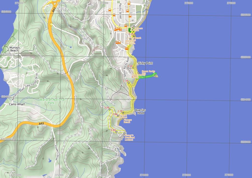
1 Wallarah Coastal Walk 3 hrs 8.3 km Return Hard track 247m This walk starts at Caves Beach and travels south along the coastline, until reaching the Pinney s Headland Lookout. There are many opportunities to stop, relax and swim if you would like. You will meander through coastal heath vegetation, which offers abundant wildflowers during springtime. There are spectacular views over the coast and the side trip to Spoon Rocks Spit offers a chance to look back at the attractive coastline. This walk takes you into a seldom visited part of Wallarah Pennisula. 4 Maps, text & images are copyright wildwalks.com Thanks to OSM, NASA and others for data used to generate some map layers. 5m Lake Macquarie LGA 44m

2 Wallarah Pennisula Wallarah Penisula, also referred to as the Swansea Pennisula, is surrounded by water and includes the Wallarah National Park. The Wallarah Pennisula stretches from Lake Macquarie in the west to the ocean in the east, from Swansea and Caves Beach in the north to Catherine Hill Bay and Lake Munmorah in the south. Within the Wallarah National Park, there are plenty of things to do, including walking, fishing, swimming and surfing. The coastal views are spectacular, and this is also a good whale watching spot. The Wallarah National Park co-operates with its park neighbours, including Stockland Wallarah Peninsula Pty Ltd, on a wide range of issues relating to the management of the Wallarah Peninsula through a joint management agreement. Stuart Chalmers Park Named after a cancer victim, Stuart Chalmers Park is a well established park close to Caves Beach. Stuart Chalmers Park has toilets, car parking, water, sheltered electric barbeques and picnic tables. The park has easy access to Caves Beach, the cafe Acquablu and the Caves Beach SLSC. Caves Beach SLSC The Swansea-Caves Beach Surf Life Saving Club, south of Newcastle, was founded in The SLSC looks after Caves Beach, which runs from this southern end of the beach, for 3m to the northern Swansea (Hams) Beach. A road runs the length of the beach, with car parking along much of it. Though Caves Beach faces the south-east, it is afforded a moderate degree of wave protection by reefs in the centre and north and Spoon Rocks to the south-east. More info. Caves Beach Lookout The Cave Beach Lookout, on the southern headland of Caves Beach, is easily accessible via wheelchair from the car park nearby. The lookout offers excellent views over the caves of Caves Beach and also to the north and south. There are is a large stone viewing platform on which to sit and enjoy the views. Spoon Rocks Beach Spoon Rocks Beach, south of Caves Beach is a sheltered sandy beach. Spoon Rocks breakwater forms the southern end of the beach and has allowed sedimentation of sand to occur and created this attractive beach. The beach is 3m long, faces north-east and is good for swimming. The Spoon Rocks Beach is worth the walk in to it. Before You walk Bushwalking is fun and a wonderful way to enjoy our natural places. Sometimes things go bad, with a bit of planning you can increase your chance of having an ejoyable and safer walk. Before setting off on your walk check 1) Weather Forecast (BOM Hunter District) 2) Fire Dangers (Greater Hunter, unknown) 3) Park Alerts () 4) Research the walk to check your party has the skills, fitness and equipment required 5) Agree to stay as a group and not leave anyone to walk solo Think before you TREK The 'Think before you TREK' program developed by NSW Police & NPWS promotes the benefits of planning ahead for your bushwalking trip by using an easy to remember acronym: T R E K Take adequate supplies of food, water, navigation and first aid equipment. Register your planned route and tell friends and family when you expect to return. Emergency beacon (PLB's) should be carried on walks with significant gaps in mobile coverage (check terrain profile). Keep to your planned route and follow the map and walking trails. Topo Maps The maps provided on wildwalks are helpful, but there are times where you may need maps covering a broader area. Maps that cover this walk include; 1:25 Map Series:92314S CATHERINE HILL BAY, 92314N SWANSEA 1:1 Map Series:9231 LAKE MACQUARIE Grade This walk has been graded using the AS The overall grade of the walk is dertermined by the highest classification along the whole track. 4 Length Time Quality of track Grade 4/6 Hard track 8.3 km Return 3 hrs Formed track, with some branches and other obstacles (3/6) Signs Minimal directional signs (4/6) Experience Required Weather Infrastructure Some bushwalking experience recommended (3/6) Weather generally has little impact on safety (1/6) Limited facilities (such as cliffs not fenced, significant creeks not bridged) (4/6)
3 Are you ready to have fun? Please ensure you and your group are well prepared and equipped for all possible hazards and delays. Check park closures, weather information and Fire Danger Rating before setting out. Optional side trips and alternate routes noted are not included in this walks overall grade, length or time estimate. Please allow extra time for resting and exploring areas of interest. The authors, staff and owners of wildwalks take care in preparing this information but will not accept responsibility for any inconvenience, loss or injury you may experience. Please take care, have fun - Happy Walking. Getting there You can get to Cafe Acquablu on Caves Beach (gps: , ) by car or bus. Car: There is free parking available. This is a return, so you will finish back at the start. Find up to date and more information inlcuding; travel directions, weather, park closures and walker feedback at Wallarah Pennisula Wallarah Penisula, also referred to as the Swansea Pennisula, is surrounded by water and includes the Wallarah National Park. The Wallarah Pennisula stretches from Lake Macquarie in the west to the ocean in the east, from Swansea and Caves Beach in the north to Catherine Hill Bay and Lake Munmorah in the south. Within the Wallarah National Park, there are plenty of things to do, including walking, fishing, swimming and surfing. The coastal views are spectacular, and this is also a good whale watching spot. The Wallarah National Park co-operates with its park neighbours, including Stockland Wallarah Peninsula Pty Ltd, on a wide range of issues relating to the management of the Wallarah Peninsula through a joint management agreement. Stuart Chalmers Park Named after a cancer victim, Stuart Chalmers Park is a well established park close to Caves Beach. Stuart Chalmers Park has toilets, car parking, water, sheltered electric barbeques and picnic tables. The park has easy access to Caves Beach, the cafe Acquablu and the Caves Beach SLSC. Caves Beach SLSC The Swansea-Caves Beach Surf Life Saving Club, south of Newcastle, was founded in The SLSC looks after Caves Beach, which runs from this southern end of the beach, for 3m to the northern Swansea (Hams) Beach. A road runs the length of the beach, with car parking along much of it. Though Caves Beach faces the south-east, it is afforded a moderate degree of wave protection by reefs in the centre and north and Spoon Rocks to the south-east. More info. Cafe Acquablu on Caves Beach (14 m 3 mins) From Cafe Acquablu, this walk leaves the concrete footpath and enters Caves Beach, turning to the right. This walk then follows the sandy beach, keeping the ocean on your left, and after about 8m, crosses a small creek and comes to the bottom of timber steps. Continue straight: From the bottom of the timber steps on Caves Beach, this walk follows the steps up, leaving the beach behind. This walk continues for about 5m up the concrete and timber steps, until coming to a four-way intersection (with uphill concrete steps directly ahead)..14 Four way intersectin (Caves Beach) (12 m 2 mins) Turn left: From the intersection, this walk follows the footpath gently uphill, while keeping the downhill concrete steps and beach on your left. This walk continues for about 6m until coming to a three-way intersection with a concrete footpath on the right. Veer left: From the intersection, this walk follows the footpath gently downhill, while keeping the ocean on your left. This walk continues for about 5m, undulating gently through coastal vegetation and crossing over a timber footbridge, until coming to the circular concrete structure of Caves Beach Lookout..25 Caves Beach Lookout The Cave Beach Lookout, on the southern headland of Caves Beach, is easily accessible via wheelchair from the car park nearby. The lookout offers excellent views over the caves of Caves Beach and also to the north and south. There are is a large stone viewing platform on which to sit and enjoy the views..25 Caves Beach Lookout (91 m 17 mins) Turn sharp right: From Caves Beach Lookout, this walk follows the gravel and grass track gently uphill, while keeping the ocean on your left. This walk continues, undulating gently through coastal vegetation for about 3m, until coming to Caves Beach Road. Turn left: From the intersection, this walk follows the track beside Caves Beach Road gently downhill, while keeping the ocean on your left. This walk continues for about 11m, to find the track gently uphill and moving away from Caves Beach Road. Then the walk continues for about 1m and passes between a metal posted fence. This walk continues for about 4m, undulating through coastal vegetation with views on the left, until passing over a timber footbridge and coming to a three-way intersection with a concrete footpath on the right Int of Coastal Walk & Seacliff track (28 m 5 mins) Veer left: From the intersection, this walk follows the bitumen track gently downhill, while keeping the concrete footpath on your right. This walk continues for about 12m through coastal vegetation with views of Spoon's Rocks on the left, to pass through metal posts and onto a sandy track. Then the walk continues for about 16m, until climbing gently up to the land end of Spoon Rocks Spit Spoon Rocks Beach Spoon Rocks Beach, south of Caves Beach is a sheltered sandy beach. Spoon Rocks breakwater forms the southern end of the beach and has allowed sedimentation of sand to occur and created this attractive beach. The beach is 3m long, faces north-east and is good for swimming. The Spoon Rocks Beach is worth the walk in to it Optional sidetrip to End of Spoon Rocks Spit (47 m 8 mins) Turn left: From the intersection, this walk follows the rocky Spoon Rocks Spit out to its end, while moving directly away from the main coastline. This walk continues to follow the rocky spit (initially keeping to the Spoon Rocks Beach side of the spit) for about 5m, until coming to the end of Spoon Rocks Spit. This track is rocky and exposed to the ocean. At the end of this side trip, retrace your steps back to the main walk then Continue straight Spoon Rocks Spit Spoon Rocks Spit is a wide breakwater extending 5m out into the ocean. This breakwater was originally designed as a coal loading facility to offload coal mined from the nearby Wallarah seam. The rocks were cut from the cliff face below the spit. Over time, the force of the ocean waves have breached the breakwater. Sedimentation from these ocean forces has established a safe and protected swimming and beach area to the north of the spit Int of Coastal Walk & Spoon Rocks Track (34 m 7 mins) Turn right: From the intersection, this walk follows the track gently uphill, while leaving Spoon Rocks Spit and the ocean on your left. This walk continues for about 4m (ignoring side tracks) through coastal vegetation and becoming moderately steep uphill, until coming to a threeway intersection with a bridged track and 'Wallarah Peninsula Coastal Walk' sign on the left Int of Coastal Walk AND Quarries Track (99 m 21 mins) Turn left: From the intersection, this walk crosses a footbridge and follows the moderately steep uphill track, while passing the 'Wallarah Peninsula Coastal Walk' sign on your left. This walk continues for about 14m, then climbs up timber steps to a viewing spot over Spoon Rocks Spit. Then the walk continues for about 2m, to a three-way intersection. This walk turns left, following the arrow marker on a timber post. Then this walk continues for about 4m, as the track undulates gently downhill with views and a metal fence on your left, to pass through a timber fenced opening. The walk then continues moderately steeply downhill, initially with a timber fence on your right for about 8m to find blank information signs at Split Rocks Headland. The walk continues gently downhill for about 3m, with a short section of timber boardwalk and views of Pinney's Beach, until coming to a timber viewing platform and Pinney's Lookout Pinneys Lookout Pinney's Lookout overlooks the northern side of Pinney's Beach on the Wallarah Peninsula. From this timber platform, the whole of Pinney's Beach can be seen, including Pinney's Headland to the south. Some of the timber on this lookout was missing when visited, so take care Pinneys Viewpoint (18 m 3 mins) Continue straight: From Pinney's Viewpoint, this walk follows the track gently downhill, while keeping Pinney's Beach on your left. This walk continues for about 7m, including one section of timber boardwalk, until coming to a T-intersection with a narrow management trail and blank sign on the right. Turn left: From the intersection, this walk follows Pinneys Trail gently downhill, while keeping the track with a blank sign on your left. This walk continues for about 1m through coastal vegetation, until crossing Pinney's Creek via a timber footbridge and coming to a three-way intersection, with Pinney's Beach on the left Pinneys Beach Pinney's Beach is a good beach for fishing, surfing and swimming. This beach is accessible on foot, via the coastal walk. This beach is not patrolled and rock platforms can be dangerous, even when the seas appear calm. Personal fishing is permitted off all the coast in Wallarah National Park, although a licence is needed. A midden (dated to about 12 years old), with about 2 stone artefacts, was discovered here in the 196s, but unfortunately 4WD vehicles have caused erosion to this site. More info Int of Coastal Walk AND Pinneys Beach (32 m 5 mins) Turn right: From the intersection, this walk follows the trail gently uphill, while leaving the bridge and creek on your right. This walk continues for about 16m, passing around a locked gate. Then this walk continues through coastal bush for about 15m, until coming to a three-way intersection, with a 'Coastal Walk' sign Int of Coastal Walk & Wallarah Walk (54 m 12 mins) Turn left: From the intersection, this walk follows the 'Coastal Walk' sign gently uphill. This walk continues moderately steeply uphill for about 4m, and comes to a three-way intersection. Then this walk tends left, following an arrow marker on a timber post, and after about 4m, comes to a three-way intersection. This walk tends left, following an arrow marker on a timber post, for about 8m, coming to a three-way intersection with the gently downhill Shark Bay trail on the right.

4 3.82 Int of Coastal Walk & Shark Bay Track (12 m 2 mins) Continue straight: From the intersection, this walk follows the trail gently downhill to the left, while keeping the gently downhill Sharks Bay trail on your right. This walk continues, undulating gently for about 11m, until coming to a three-way intersection, with a arrow marker on the left Int of Coastal Track & Southern Loop Junction (19 m 3 mins) Veer left: From the intersection, this walk turns left on the trail and follows the timber arrow marker gently downhill. This walk continues, undulating gently for about 18m, until coming to a timber fence and Pinney's Lookout on the left (just as the trail turns right) Pinney's Headland Lookout There are magnificent vistas from Pinney's Headland Lookout, particularly to the north. The headland is accessed on foot via the Wallarah Peninsula coastal walk, and the headland itself has a loop walking trail on it. At the southernmost point of this walking loop, there are unfenced rock platforms forming the ocean shoreline - take care. More info.
5
6 Powered by TCPDF ( Summary navigation sheet for the Wallarah Coastal Walk km From Up/Dwn Length Initial directions (Use full tracknotes and maps for more detail). Cafe Acquablu on Caves Beach , (GR Swansea, ) m 3 mins From Cafe Acquablu, this walk leaves the concrete footpath and enters Caves Beach, turning to the right..14 Four way intersectin (Caves Beach) , (GR Swansea, ) m 2 mins Turn left: From the intersection, this walk follows the footpath gently uphill, while keeping the downhill concrete steps and beach on your left..25 Caves Beach Lookout , (GR Swansea, ) m 17 mins Turn sharp right: From Caves Beach Lookout, this walk follows the gravel and grass track gently uphill, while keeping the ocean on your left Int of Coastal Walk & Seacliff track , (GR Swansea, ) m 5 mins Veer left: From the intersection, this walk follows the bitumen track gently downhill, while keeping the concrete footpath on your right Int of Coastal Walk & Spoon Rocks Track , (GR Swansea, ) m 8 mins Optional sidetrip to End of Spoon Rocks Spit. Turn left: From the intersection, this walk follows the rocky Spoon Rocks Spit out to its end, while moving directly away from the main coastline Int of Coastal Walk & Spoon Rocks Track , (GR Swansea, ) m 7 mins Turn right: From the intersection, this walk follows the track gently uphill, while leaving Spoon Rocks Spit and the ocean on your left Int of Coastal Walk AND Quarries Track , (GR Swansea, ) m 21 mins Turn left: From the intersection, this walk crosses a footbridge and follows the moderately steep uphill track, while passing the 'Wallarah Peninsula Coastal Walk' sign on your left Pinneys Viewpoint , (GR Catherine Hill Bay, ) m 3 mins Continue straight: From Pinney's Viewpoint, this walk follows the track gently downhill, while keeping Pinney's Beach on your left Int of Coastal Walk AND Pinneys Beach , (GR Catherine Hill Bay, ) 1 32 m 5 mins Turn right: From the intersection, this walk follows the trail gently uphill, while leaving the bridge and creek on your right Int of Coastal Walk & Wallarah Walk , (GR Catherine Hill Bay, ) m 12 mins Turn left: From the intersection, this walk follows the 'Coastal Walk' sign gently uphill Int of Coastal Walk & Shark Bay Track , (GR Catherine Hill Bay, ) m 2 mins Continue straight: From the intersection, this walk follows the trail gently downhill to the left, while keeping the gently downhill Sharks Bay trail on your right Int of Coastal Track & Southern Loop Junction , (GR Catherine Hill Bay, ) m 3 mins Veer left: From the intersection, this walk turns left on the trail and follows the timber arrow marker gently downhill.
The Foreshore Walk. 24m. 1m Lake Macquarie LGA. 1 hr 15 mins 2.9 km One way. Hard track 81m
 The Foreshore Walk 1 hr 15 mins 2.9 km One way Hard track 81m This walk traverses the coastline of the Green Point reserve. By following a variety of tracks and occasionally traveling inland through eucalyptus
Campbell Drive to Snapper Point
 Campbell Drive to Snapper Point 1 hr 45 mins 4.2 km One way Experienced only 135m This walk follows the Coast Track to Frazer Beach, along the Geebung and (overgrown) Grass Tree Tracks. From the northern
Wattamolla to Big Marley Beach
 Wattamolla to Big Marley Beach 4 hrs 10.4 km Circuit Moderate track 4m This walk is an excellent loop which takes in both the coast and the heathy inland of Royal National Park. Nearly the whole walk has
Hunters Hill to Epping Road
 Hunters Hill to Epping Road 2 hrs 30 mins 5.5 km One way Moderate track 154m An enjoyable walk through lower sections of the Lane Cove National Park, this walk features plenty of mangroves next to the
Morgans Creek to Padstow
 Morgans Creek to Padstow 2 hrs 45 mins 8 km One way Moderate track 3 144m This pleasant walk starts from the Morgans Creek park, at Henry Lawsons Drive, and follows the Georges River past the Boomerang
Green Point Circuit Walk
 Green Point Circuit Walk 3 hrs 7.7 km Circuit Hard track 269m This walk visits all of the popular locations in Green Point Reserve, as well as some of the lesser-visited areas inland. Taking in Sea Eagle
Currie Rd to Davidson Park
 Currie Rd to Davidson Park 3 hrs 7.2 km One way Moderate track 28m Starting at Currie Rd in Forestville, this walk follows Middle Harbour to Davidson Park, under Roseville Bridge. There are two optional
Wentworth Falls Conservation Hut Loop
 Wentworth Falls Conservation Hut Loop 3 hrs Hard track 6.7 km Circuit 4 341m This scenic walk from Wentworth Falls Station, winds along the Nature Trail to Conservation Hut, then drops into the magnificent
Govetts Leap Loop. 1065m. 909m Blue Mountains National Park. 4 hrs 30 mins 8.7 km Circuit. Hard track 380m
 Govetts Leap Loop 4 hrs 30 mins 8.7 km Circuit Hard track 380m This walk, from Blackheath Train Station, is a fantastic way to see some of the iconic areas of the Blue Mountains in the Blackheath area.
Popes Glen, Pulpit Rock, Govetts Leap and Braeside Walk
 Popes Glen, Pulpit Rock, Govetts Leap and Braeside Walk 8 hrs Hard track 13.6 km Circuit 4 1068m This large circuit walk, from Popes Glen to Pulpit Rock, Govetts leap and along the Braeside Track, passes
Teralba to Charlestown Park track head
 Teralba to Charlestown Park track head 4 hrs 30 mins 13.3 km One way Moderate track 3 220m This section of the Great North Walk starts from the Teralba train station and winds down and around the edge
Sid Pulsford Walk. 175m. 33m. 1 hr 45 mins 4.1 km One way. Hard track 118m. Gosford LGA
 Sid Pulsford Walk 1 hr 5 mins.1 km One way Hard track 118m Sid Pulsford Walk explores the ridge top of Kincumber Mountain, from Honeman's Rock to Green Point. The walk mostly follows wide management trails.
Echo Point to Leura Forest via Three Sisters and Giant Stairs loop
 Echo Point to Leura Forest via Three Sisters and Giant Stairs loop 3 hrs 3.8 km Circuit Hard track 512m This walk starts from the popular Echo Point, in Katoomba, and winds down to the base of the Three
Balmoral Beach to The Spit
 Balmoral Beach to The Spit 2 hrs 30 mins.3 km One way Hard track 85m This walks follows the coast from Balmoral to the Spit and across Spit Bridge. There are some alternate tracks to consider at high-tides,
Waterfall to Heathcote
 Waterfall to Heathcote 5 hrs Hard track 10.8 km One way 4 467m This walk explores the heart of Heathcote National Park, and is easily accessed with a train station at either end. Although relatively close
Hornsby Blue Gum Walk
 Hornsby Blue Gum Walk 3 hrs Hard track 6.7 km Circuit 4 374m This delightful loop is one of the prettiest and most popular walks in the Hornsby area. Going from an environment of ferns and clear bushland
Epping to Pennant Hills Station (via Lane Cove River)
") Epping to Pennant Hills Station (via Lane Cove River) 3 hrs 5 mins 8.4 km One way Hard track 249m This walk, from Epping to Pennant Hills Station, is a great way to see the upper Lane Cove River Valley.
Epping to Pennant Hills Station (via Lane Cove River) 3 hrs 5 mins 8.4 km One way Hard track 249m This walk, from Epping to Pennant Hills Station, is a great way to see the upper Lane Cove River Valley.
The Basin Track and Mackerel Track
 The Basin Track and Mackerel Track 3 hrs 5.9 km Circuit Hard track 226m This walk is a great way to see some popular areas in Ku-ring-gai Chase National Park. The walk from West Head Rd travels to The
Rail to River Walk. 3 hrs. Hard track 7.5 km Circuit. 222m
 Rail to River Walk 3 hrs Hard track 7.5 km Circuit 4 222m This walk is a great one from Chatswood Station to the Lane Cove River National Park. The walk descends through the vegetated bushland which fills
Carrington Park to Leura Forest and pass loop
 Carrington Park to Leura Forest and pass loop 3 hrs Hard track 4.8 km Circuit 4 674m This walk is a fantastic way to see Leura Forest. The walk descends from Carrington Park, visiting Leura Forest and
Mackerel Beach, West Head Loop
 Mackerel Beach, West Head Loop 5 hrs 8.6 km Circuit Hard track 422m The Mackerel Beach, West Head Loop is a walk which explores a large part of the West Head. The journey starts and finishes with a ferry
Katoomba Falls Circuit
 Katoomba Falls Circuit hr 5 mins.5 km Circuit Hard track 59m For those looking for a walk involving more than simple boardwalk, this trail winding through the temperate rain forest could be just the thing.
Little Digger Track to Davidson Reserve and Lyrebird Circuit
 Little Digger Track to Davidson Reserve and Lyrebird Circuit 4 hrs 3 mins 11.5 km One way Hard track 4 47m Exploring both the eastern and western sides of Middle Harbour Creek, this walk follows the Little
Bouddi Coastal Walk. 5 hrs. Hard track 8.1 km One way. 364m
 Bouddi Coastal Walk 5 hrs Hard track 8.1 km One way 4 364m This is one of the longer walks in the Bouddi National Park and it is rich in scenery. The walk follows the coastline with many side trips to
Little Digger Track. 68m. 1 Hr 2.2 km One way. Moderate track 93m. Moores Creek Reserve
 Little Digger Track Hr 2.2 km One way Moderate track 93m This walk follows Moores Creek through several reserves in east Roseville and East Lindfield. The track is named after Australia's 7th Prime Minster,
Heathcote to Engadine via Audley
 Heathcote to Engadine via Audley 6 hrs 3 mins 5 km One way Hard track 4 635m Covering a large section of central Royal National Park, this walk goes through the heath and scrub along a well managed and
Dead Horse Gap Loop track
 Dead Horse Gap Loop track 4 hrs 30 mins Hard track 9.8 km Circuit 144m 4 This walk starts with a ride up the Kosciuszko Express Chairlift. There is an opportunity to eat at Australia's highest restaurant,
Mackerel Beach and Resolute Loop
 Mackerel Beach and Resolute Loop 3 hrs 5.4 km Circuit Hard track 384m This walk is another great walk in Ku-ring-gai Chase National Park, accessed by ferry. From the Mackerel Beach wharf, this walk uses
Epping to Eastwood Station (via Lane Cove River)
") Epping to Eastwood Station (via Lane Cove River) hrs 45 mins 10.2 km One way Moderate track 189m Epping to Eastwood, via Lane Cove River, is the longer route through the bush between the stations. This
Epping to Eastwood Station (via Lane Cove River) hrs 45 mins 10.2 km One way Moderate track 189m Epping to Eastwood, via Lane Cove River, is the longer route through the bush between the stations. This
Callicoma Loop. 174m. 98m. 2 hrs. Hard track 5.1 km Circuit. 153m
 Callicoma Loop 2 hrs Hard track 5.1 km Circuit 153m This great circuit walk passes through some really nice forest around the fringe of Cherrybrook. Highlights of the walk include some beautiful rock overhangs
Scenic World to Echo Point
 Scenic World to Echo Point 1 hr 15 mins 2.1 km One way Moderate track 192m This is one of the most popular tourist walks in the Katoomba area. The walk follows the cliffs along a well maintained and signposted
Upper Rumbalara circuit
 Upper Rumbalara circuit 1 hr 30 mins 3.3 km Circuit Hard track 176m A great circuit walk, covering most of the walking tracks and sights in the upper section of the Rumbalara Reserve. There is some really
Spit Bridge to Middle Head Forts
 Spit Bridge to Middle Head Forts 2 hrs 30 mins 6.3 km One way Hard track 4 181m This scenic walk takes you from the Spit Bridge, along the coast to explore the Middle Head Forts. There are a few alternate
Berowra to Mt Kuring-gai
 Berowra to Mt Kuring-gai 4 hrs 30 mins 9.4 km One way Hard track 4 551m From the ridges above Cowan Creek, this walk takes in some great lookouts (especially around Mt Kuringgai) as well as enjoying an
Rail to River and Stringybark Creek Reserve Walk
 Rail to River and Stringybark Creek Reserve Walk 4 hrs Hard track 11.2 km Circuit 4 302m This walk begins in the busy city of Chatswood and soon enters the nearby bushland around the Lane Cove River. The
National Pass from Wentworth Falls to Conservation Hut
 National Pass from Wentworth Falls to Conservation Hut 3 hrs Hard track 3.6 km One way 739m Starting at Wentworth Falls picnic area, this scenic and historic walk explores many waterfalls, lookouts and
De Burgs Bridge to Thornleigh station
 De Burgs Bridge to Thornleigh station 3 hrs 45 mins 9.7 km One way Hard track 4 363m This walk follows a section of the Great North Walk, starting from De Burghs bridge. The walk winds north west, through
Middle Harbour Creek Loop
 Middle Harbour Creek Loop 5 hrs 45 mins 15.1 km Circuit Experienced only 5 570m This walk explores the upper reaches of Middle Harbour Creek, starting and ending at the great parklands at Davidson Park,
Patonga to Woy Woy. 5 hrs 45 mins 15.5 km One way. Hard track. 497m
 Patonga to Woy Woy 5 hrs 45 mins 15.5 km One way Hard track 4 497m This walk explores a variety of environments from the shore line and coastal cliffs near Patonga, to the dry, rocky and open ridge line.
Sphinx, Warrimoo and Bobbin Head tracks
 Sphinx, Warrimoo and Bobbin Head tracks 4 hrs 9.6 km Circuit Moderate track 499m This great walk starts at the Sphinx Memorial and loops around via Cowan Creek, exploring diverse environments as it changes
Under and Over Cliff Walk
 Under and Over Cliff Walk 4 hrs 9.4 km Circuit Moderate track 576m This walk from Wentworth Falls Station is a fantastic way to see a large majority of the Wentworth Falls cliffline. The track winds under
Blackheath Station to Junction Rock Loop (via Grand Canyon and Popes
 Blackheath Station to Junction Rock Loop (via Grand Canyon and Popes 8 hrs 30 mins 18.2 km Circuit Hard track 4 1254m This circuit starts in Blackheath and heads down into the Grand Canyon and Rodriguez
Woolwich Wharf to Boronia Park
 Woolwich Wharf to Boronia Park 2 hrs 5.8 km One way Moderate track 175m Going through the streets of Hunters Hill, this walk is on the first segment of the Great North Walk. The majority of the walk is
Wentworth Falls Station Loop (Undercliff Walk)
") Wentworth Falls Station Loop (Undercliff Walk) 4 hrs 3 mins Hard track 8.9 km Circuit 658m 4 This walk passes some stunning waterfalls and views into the Jamison Valley, following the cliff edges around
Wentworth Falls Station Loop (Undercliff Walk) 4 hrs 3 mins Hard track 8.9 km Circuit 658m 4 This walk passes some stunning waterfalls and views into the Jamison Valley, following the cliff edges around
Taronga Wharf to Chowder Bay
 Taronga Wharf to Chowder Bay 2 hrs 4.4 km One way Moderate track 246m Starting at Taronga Wharf, this walk passes many icons of Sydney, including Taronga Zoo, HMAS Sydney Mast, Chowder Bay. The walk also
Charlestown Park trackhead to Newcastle station
 Charlestown Park trackhead to Newcastle station 5 hrs 30 mins 12.1 km One way Hard track 4 287m This section of the Great North Walk starts from the Charleston Park track head and winds through the streets
De Burghs Bridge to Fullers Bridge
 De Burghs Bridge to Fullers Bridge 2 hrs 3 mins Hard track 6 km One way 2m 4 Following the Lane Cove River, this walk mostly follows a section of the Great North Walk and is well maintained and signposted.
Glenbrook and Euroka Circuit
 Glenbrook and Euroka Circuit 2 Days 16.6 km Circuit Experienced only 790m This two day circuit, returning to Glenbrook Station, is a scenic walk which passes many of the tourist attractions within the
Epping to Gordon Station
 Epping to Gordon Station 4 hrs 15 mins 11.7 km One way Hard track 4 365m This walk, from Epping Station to Gordon Station, passes below the homes which sit on the hills high above the Lane Cove River.
Hermitage Foreshore Track
 Hermitage Foreshore Track 1 Hr 2.2 km One way Moderate track 123m The Hermitage Foreshore Walk is a wonderful way to explore Sydney Harbour from the perspective of South Head. This walk starts from Nielsen
Dubbo Gully and Ten Mile Hollow Circuit (via Clares Bridge)
") Dubbo Gully and Ten Mile Hollow Circuit (via Clares Bridge) 2 Days Hard track 24.3 km Circuit 4 1117m This two day (or ten hour) walk follows several historic roads, now closed to traffic. Starting with
Dubbo Gully and Ten Mile Hollow Circuit (via Clares Bridge) 2 Days Hard track 24.3 km Circuit 4 1117m This two day (or ten hour) walk follows several historic roads, now closed to traffic. Starting with
Federal Pass Walking Track
 Federal Pass Walking Track 5 hrs Hard track 8 km One way 4 989m This classic trail follows along the base of the cliffs from Leura to the Golden Stairs, passing many of the more popular sights of the Katoomba
Roseville to Macquarie Park
 Roseville to Macquarie Park 3 hrs 3 mins 8.8 km One way Hard track 4 29m This walk starts at Roseville station and explores the streets and alleyways of Roseville before joining the main spine of the Great
Cape Banks Circuit. 50m. 2m Botany Bay National Park. 3 hrs 7.3 km Circuit. Hard track 190m
 Cape Banks Circuit 3 hrs 7.3 km Circuit Hard track 19m This Cape Banks Circuit has a lot to offer and is thoroughly recommended. The walking travels over beaches, through coastal forest and across exposed
Wentworth Falls Station Loop
 Wentworth Falls Station Loop 5 hrs 3 mins 9.5 km Circuit Hard track 4 13m The Wentworth Falls Station Loop takes in most of the upper tracks around Wentworth Falls. There are many scenic views near the
Thornleigh to Hornsby
 Thornleigh to Hornsby 4 hrs Hard track 10.2 km One way 4 526m Starting at Thornleigh station you walk through suburban streets for a short while before diving into the bush at the southern end of Berowra
The Coast Track. 2 Days. Hard track 27.4 km One way. 1351m
 The Coast Track 2 Days Hard track 27.4 km One way 4 1351m Heading south, this walk covers the coastline of the Royal National Park and can truly only be described as amazing. With breathtaking coastal
Rumbalara Explorer. 158m. 5m Rumbalara Reserve. 2 hrs 45 mins 6.1 km Circuit. Hard track 326m
 Rumbalara Explorer 2 hrs 5 mins 6.1 km Circuit Hard track 326m Pretty well the grand tour of the Rumbalara Reserve, this walk takes in much of the great scenery the reserve has to offer. The walk covers
Echo Point to Leura Forest Circuit
 Echo Point to Leura Forest Circuit 3 hrs 4.8 km Circuit Hard track 588m Forming a circuit around the cliffs and then the valley floor, this is a walk more then capable of convincing a walker of the beauty
Gosford to Lisarow. 202m
 Gosford to Lisarow 4 hrs 3 mins Hard track 11.3 km One way 4 479m This walk is a great way to explore the ridge-top bushland between Gosford and Lisarow. Passing through Rumbalara and Katandra Reserves,
Wentworth Falls Loop. 893m. 665m. 6 hrs 10.2 km Circuit. Hard track 1093m. Blue Mountains National Park
 Wentworth Falls Loop 6 hrs 1.2 km Circuit Hard track 193m This is a great walk, both in size and spectacular views. The walk makes its way from Wentworth Falls train station and drops off the plateau,
Bouddi Ridge and Coastal Walk
 Bouddi Ridge and Coastal Walk 2 Days Hard track 27 km Circuit 4 126m This overnight walk takes in the majority of the magnificent Bouddi National Park. The walk starts from the pleasant Putty Beach camping
Lane Cove Tourist Park River Circuit
 Lane Cove Tourist Park River Circuit 5 hrs 12 km Circuit Hard track 383m This walk follows a large section of Lane Cove River. The walk follows the Riverside Walking track up the Lane Cove River to De
Spit Bridge to Manly (Manly Scenic Walkway)
") Spit Bridge to Manly (Manly Scenic Walkway) 3 hrs 45 mins 9.1 km One way Moderate track 349m The Spit to Manly walk is a classic bushwalk on Sydney's Northern Beaches. The walk follows a well-maintained
Spit Bridge to Manly (Manly Scenic Walkway) 3 hrs 45 mins 9.1 km One way Moderate track 349m The Spit to Manly walk is a classic bushwalk on Sydney's Northern Beaches. The walk follows a well-maintained
Gordon to Chatswood Station
 Gordon to Chatswood Station 4 hrs 30 mins 12.2 km One way Hard track 4 381m This walk is a great way to get into the bush without being far from civilisation. The walk wanders through untouched valleys
Sphinx to Mt Kuring-gai
 Sphinx to Mt Kuring-gai 4 hrs 45 mins 1.7 km One way Hard track 673m This walk starts at the Sphinx War Memorial and follows some well maintained and popular walking tracks down to Cowan Creek. Enjoy the
Faulconbridge to Blaxland
 Faulconbridge to Blaxland 2 Days Experienced only 15.2 km One way 5 693m This two-day walk, or very solid one-day walk, takes you from station to station, through lush, scenic forest in the lower Blue
North Ryde Fairyland circuit
 North Ryde Fairyland circuit 2 hrs 30 mins Hard track 6.9 km Circuit 193m 4 Starting at North Ryde train station this walk explores a stretch of the Lane Cove River, visiting the historic Fairlylands Pleasure
Bobbin Head Loop. 166m. 0m Ku-ring-gai Chase National Park. 5 hrs 12.9 km Circuit. Hard track 619m
 Bobbin Head Loop 5 hrs 12.9 km Circuit Hard track 619m This great circuit walk enjoys a variety of landscapes in Ku-ring-gai Chase National Park. The walk starts at the historic Sphinx war memorial and
Manly to Seaforth Oval
 Manly to Seaforth Oval 5 hrs 45 mins 13.7 km One way Moderate track 3 624m This walk follows the Manly to Spit Scenic Walkway, then continues past The Spit Bridge to Seaforth Oval. The walk provides magnificent
Scenic world to Three Sisters Loop via Furber Steps
 Scenic world to Three Sisters Loop via Furber Steps 5 hrs 5.8 km Circuit Hard track 722m This walk starts from the popular Scenic World, in Katoomba, and winds down the Furber steps into the Jamison Valley,
Narrabeen Lagoon Trail (from Middle Creek)
") Narrabeen Lagoon Trail (from Middle Creek) 2 hrs 30 mins 8.6 km Circuit Very easy 1 105m The Narrabeen Lagoon Trail is a wonderful and accessible walk on the Northern Beaches of Sydney. The trail is used
Narrabeen Lagoon Trail (from Middle Creek) 2 hrs 30 mins 8.6 km Circuit Very easy 1 105m The Narrabeen Lagoon Trail is a wonderful and accessible walk on the Northern Beaches of Sydney. The trail is used
Taronga Zoo to Spit Bridge
 Taronga Zoo to Spit Bridge 5 hrs Hard track 1.4 km One way 4 41m This is a scenic and culturally rich walk with views over Sydney Harbour and many interesting heritage buildings along the way. The start
Light to Light Walk 2 days
 Light to Light Walk 2 days 2 Days Hard track 3.9 km One way 4 794m Over two days, this classic walk explores the coast from Boyd Tower to the Green Cape Lighthouse in the south. Hegartys Bay Camp is over
Chatswood to Epping Station
 Chatswood to Epping Station 6 hrs Hard track 16.3 km One way 4 533m This walk, from Chatswood to Epping, is a long but enjoyable walk along the Lane Cove valley. The walk mostly follows the Lane Cove River
Six Foot Track. 1212m
 Six Foot Track 3 Days 44.8 km One way Hard track 4 2066m This classic walk takes you from Katoomba to Jenolan Caves via a historic horse route. The walk travels mainly along well-maintained service tracks
Sydney to Thornleigh via Lane Cove Tourist Park
 Sydney to Thornleigh via Lane Cove Tourist Park 2 Days 33 km One way Hard track 4 1114m This overnight walk starts from the Obelisk in Macquarie Park, Sydney, at the official start of the Great North Walk.
Where an active. community lives...
 Murrays Beach on Lake Macquarie is the natural choice for coastal living. Nestled in the relaxed open space of Lake Macquarie and Wallarah National Park this active lakeside community enjoys all the benefits
RILLINGTON TO MALTON by Tania Dickinson
 RILLINGTON TO MALTON by Tania Dickinson This walk takes you from the Vale of Pickering up on to the Wold scarp, before dropping down again through the pretty village of Settrington and joining the Centenary
THE WELLDIGGERS ARMS, HESWORTH AND FITTLEWORTH TRAIL
 THE WELLDIGGERS ARMS, HESWORTH AND FITTLEWORTH TRAIL 5.5 miles Circular 3 hours 041017 Challenging Terrain A 300-year-old pub turned country-inn on the edge of the South Downs National Park, The Welldiggers
10 Miles Circular 5 hours
 VISIT RYEDALE PICKERING AND CAWTHORN CAMPS 10 Miles Circular 5 hours Moderate Terrain 120616 A 10 mile (16km) there and back walk from the market town of Pickering in Ryedale. The route heads north through
Calaveras Big Trees State Park--South Grove Loop
 Copyright 1999 by Jeff Robinson. You are free to use and reproduce this description for personal, not-for-profit, and not-forbusiness use. Any reproduction other than for personal use, including businesses,
Beautiful Walks from the Blue Ball Inn
 Walk No. 7 COAST AND VALLEY WALK Countisbury, Glenthorne, County Gate, Brendon, Rockford and Wilsham 10 MILES APPROX. Walking time 5 hours approx. (not including breaks)> OS Sheet 64/74 Lynton and Lynmouth.
Rhossili - Tears Point - Mewslade Bay - Talgarth's Well - Rhossili - ID: 148. Walk description:
 Walk description: A glorious walk combining thrilling cliffs with beautiful wild beaches and a bird's-eye view of the Gower peninsula from Rhossili Down. The adventurous can walk out to the Worm's Head
Impacts of breakwaters and training walls
 Across the eastern seaboard of Australia, breakwaters and training walls have instigated fundamental perturbations to coastal and estuary processes. This has induced long-term changes to foreshore alignments,
Coasts. 1. Coastal Processes. 1.1 Coastal erosion. 1.2 Sediment transport. Coastal Processes and Landforms. i. Hydraulic action
 Coasts Coastal Processes and Landforms 1. Coastal Processes 1.1 Coastal erosion i. Hydraulic action When waves strike against a rock surface, the waves trap air in the rock joints. This air is compressed
Welsh Newton and Woodland
 Welsh Newton and Woodland This is a 8.2km miles (approx) walk which will take about 2.5 hours at a relaxed and leisurely pace. There are a few hills but no steep inclines. Start at Llangrove bus stop and
8 Miles Circular 4 hours
 VISIT RYEDALE HELMSLEY AND RICCAL DALE 8 Miles Circular 4 hours 090616 Challenging Terrain An 8 mile (13km) circular walk from the market town of Helmsley in Ryedale. The route heads out across sheep pastures
Outdoor property Access Statement Northumberland Coast
 Outdoor property Access Statement Northumberland Coast 7a The Square, Low Newton-by-the-Sea, Alnwick, Northumberland NE66 3EL T: 01665 576874 E: northumberlandcoast@nationaltrust.org.uk Introduction The
The Mendip Way. Route Directions and Maps Wells to Frome
 The Mendip Way Route Directions and Maps Wells to Frome Website: www.mendiphillsaonb.org.uk Email: mendip@mendiphillsaonb.org.uk Facebook & Twitter: @MendipHillsAONB Phone: 01761462338 1 Wells to Shepton
Directions for Day 1: Colwood To Metchosin
 Colwood-Metchosin Page 1 of 8 Directions for Day 1: Colwood To Metchosin Start: Royal Roads University, Birds of a Feather B&B, or at Esquimalt Lagoon Finish: Your accommodation in Metchosin Time: 4-5
Walk 7: Watchet to washford
 Walk 7: Watchet to washford Length: Moderate - 7.5 miles / 12 km Good For: Theme: History Duration: 2-3 hours depending on speed of walking Notes: This is a moderate to difficult walk in places, with steps,
NEWLANDS CORNER AND ST MARTHAS
 NEWLANDS CORNER AND ST MARTHAS 10k CIRCULAR ROUTE 2½-3HRS GU4 8SE From Newlands Corner on the North Downs just outside Guildford, you can enjoy one of the most beautiful panoramas of quintessential English
Harbour Bridge to Taronga Zoo
 Harbour Bridge to Taronga Zoo 4 hrs 9.8 km One way Moderate track 389m On this walk, you will explore much of the foreshore linking Milsons Point Station to Taronga Zoo Ferry wharf. The walk is mostly
Label the diagram below with long fetch and short fetch:
 Coastal Processes Coasts are shaped by the sea and the action of waves. The processes that take place are erosion, transportation and deposition. The power of waves is one of the most significant forces
THE BECK STONE Backstone Beck on Ilkley Moor
 THE BECK STONE Backstone Beck on Ilkley Moor 1 Three different routes which take in the best of the lower slopes of Ilkley Moor, with bracken, heather, a tarn (a small mountain lake) and rushing streams.
SELF GUIDED TOURING ROUTE
 SELF GUIDED TOURING ROUTE Things to see and places to go on the loop from Orbost to Marlo, Cape Conran, Cabbage Tree and back to Orbost (or onwards to Cann River) V6 April 2017 This guide should be read
ULTRA-TRAIL AUSTRALIA May 2018 COURSE DESCRIPTION AND COURSE NOTES
 ULTRA-TRAIL AUSTRALIA 100 19-20 May 2018 COURSE DESCRIPTION AND COURSE NOTES LEG 1 Scenic World (Start) to Narrow Neck (Checkpoint 1) Course Description: From the start, at the front entrance of Scenic
ST. AGNES. you cannot put a time limit on beauty.
 ST. AGNES CIRCULAR WALKS AROUND There are many enjoyable and picturesque walks around St. Agnes most are signposted and are featured on the St. Agnes Mini-guide map. Because most of our footpaths are in
Approximate distance: 5.5 miles For this walk we ve included OS grid references should you wish to use them. Start. End
 Approximate distance: 5.5 miles For this walk we ve included OS grid references should you wish to use them. End 4 1 Start 3 2 N W E S Reproduced by permission of Ordnance Survey on behalf of HMSO. Crown