CHAPTER 7 BICYCLING, WALKING, & TRAILS: DESIGN GUIDELINES
|
|
|
- Gladys Lawson
- 6 years ago
- Views:
Transcription
1 CHAPTER 7 BICYCLING, WALKING, & TRAILS: DESIGN GUIDELINES The purpose of this chapter is to note and summarize preferred design guidelines for bicycle and pedestrian infrastructure and facilities in the SMTC area. Included in this chapter are generally accepted and representative implementation techniques for bicycle and pedestrian facilities in both New York State in particular, and the United States in general. This chapter is intended as a place for municipalities to start when trying to determine which bicycle and/or pedestrian facilities should be considered within their jurisdiction. The first section of this chapter provides information on the most commonly utilized design guideline resources in New York State. Section 7.2 examines general design guidelines for pedestrian facilities (including broad information on the Americans with Disabilities Act), bicyclist facilities, greenways and trails, innovative treatments, traffic calming, and school zones. Section 7.3 describes additional resources that are useful in providing innovative solutions for a variety of bicycle and pedestrian related situations that may affect some local communities. 7.1 Existing Design Guideline Manuals In New York State, several useful resources already exist for the design of bicycle, pedestrian and trail facilities. The New York State Department of Transportation (NYSDOT) and other agencies have published guidelines that can facilitate local efforts to implement better roads, shared use paths and other facilities for non-motorized travel. However, these resources are not always readily available to citizens and local officials. This document describes the most commonly used signs, pavement markings and design guidelines used in New York State. The communities in the SMTC region can use the tools provided in these guidelines to implement local pedestrian, bicycle and trail improvements. These guidelines are based primarily on the following reference sources: NYSDOT Highway Design Manual, Manual on Uniform Traffic Control Devices (MUTCD), America Association of State Highway and Transportation Officials (AASHTO) Guide for the Development of Bicycle Facilities, and the AASHTO Guide for the Development of Pedestrian Facilities (pending publication). These documents contain the vast majority of the design guidelines necessary for providing safe, accessible, well-designed facilities for pedestrians and bicyclists. In general, the New York State guidelines take precedence over national guidelines, while the national documents tend to include additional content on topics not specifically addressed in the New York State manuals. The SMTC library has each of these documents, which local municipalities may use while at the SMTC. Each document is briefly described on the following pages. 132
2 7.1.1 NYSDOT Highway Design Manual (Chapter 18 Facilities for Pedestrians and Bicyclists) Chapter 18, Facilities for Pedestrians and Bicyclists, within the NYSDOT Highway Design Manual is the primary source of bicycle and pedestrian design guidance for New York State. This chapter sets forth policy, procedures and guidelines for on and off-road facilities. It includes, on its first page (p. 18-1) the following text: Despite the importance of walking and bicycling, many existing streets and highways do not adequately provide for these modes of travel. Therefore, the scoping and Design Approval Documents for projects that are used by pedestrians and bicyclists should identify their needs, the objectives for meeting those needs, the design criteria, and all feasible alternatives. Designers are responsible for assuring project designs provide for safe, convenient and cost effective pedestrian and bicycle travel consistent with the objectives and design criteria developed during project scoping or preliminary design. Source: NYSDOT Highway Design Manual, Chapter 18 - Facilities for Pedestrians and Bicyclists, Revision 29, December 17, 1996, pg The most recent version of Chapter 18 is Revision 29, dated December 17, Chapter 18 of the NYSDOT Highway Design Manual is available on-line at: Manual on Uniform Traffic Control Devices (MUTCD) The Manual on Uniform Traffic Control Devices (MUTCD) establishes guidelines and warrants for signage, signals and pavement markings. There is a Federal MUTCD, and New York State has its own manual (NYS MUTCD) with unique features specific to applications within the state. Examples include a hierarchy of local, regional, state and national bicycle route signage, shared roadway bike signs, and yield to pedestrians devices and signage. According to the Cornell Local Roads Program, The NYS MUTCD is found in Volume 17B of the New York Codes, Rules and Regulations. Every municipality should have a copy. Anyone who uses or occupies a highway or road for purposes other than travel and who may affect traffic is required to comply with it. It is in compliance with the federal manual, but differs in some important ways. Failure to comply with it greatly increases the legal liability of municipalities in the event of an accident. Source: Cornell Local Roads Program The NYS MUTCD is not available on-line, but can be purchased from West Group ( or or NYS MUTCD (Volume 17B of NYCRR)). 133

3 The 2003 Federal MUTCD, which applies to conditions and devices not specifically included in the NYS MUTCD is available on-line at The Federal MUTCD is available on-line, and includes Chapter 9: Traffic Controls for Bicycle Facilities NYSDOT Highway Design Manual Chapter 25 - Traffic Calming In addition to Chapter 18, the NYSDOT Highway Design Manual contains a chapter on traffic calming. This chapter includes a wide range of facility design guidelines for balancing the needs of pedestrians, bicyclists and motorists. The introduction to the chapter contains the following description on page 25-1: A <NYSDOT> Department task force developed a policy statement and guidance on traffic calming to assist Regions through the process. Section 25.2 contains the policy statement, policy scope, and the definition and background of traffic calming. Section 25.3 contains general guidance and requirements, including general considerations. Section 25.4 provides some examples of objectives that could be achieved by traffic calming. Section 25.5 lists example test questions to help determine if traffic calming is viable. Section 25.6 explains the applicability of traffic calming techniques, and describes the speed categories established specifically for traffic calming measures. Section 25.7 outlines the importance of community involvement and the process that should be followed. Section 25.8 covers project monitoring and its importance in evaluating the effectiveness of the project. Source: The most recent version of Chapter 25 is Revision 36, dated February 5, Chapter 25 of the NYSDOT Highway Design Manual is available on-line at: 134
4 7.1.4 AASHTO Guides for Bicycle and Pedestrian Facilities The American Association of State Highway and Transportation Officials (AASHTO) published a versatile and useful bicycle facility design guide, as well as a companion guide for pedestrian facilities. AASHTO Guide for the Development of Bicycle Facilities The most recent version of this bicycle guide is the 3 rd Edition, dated The guide is described by AASHTO as follows: The guide is designed to provide information on the development of facilities to enhance and encourage safe bicycle travel. The majority of bicycling will take place on ordinary roads with no dedicated space for bicyclists. Bicyclists can be expected to ride on almost all roadways as well as separated shared use paths and even sidewalks, where permitted to meet special conditions. This guide provides information to help accommodate bicycle traffic in most riding environments. It is not intended to set forth strict standards, but, rather, to present sound guidelines that will be valuable in attaining good design sensitive to the needs of both bicyclists and other highway users. Source: NID=B727279D15B5225A862569AC006005E8 AASHTO Guide for the Planning, Design and Operation of Pedestrian Facilities The pedestrian guide was published in late 2004 and is described by AASHTO as follows: The purpose of this guide is to provide guidance on the planning, design, and operation of pedestrian facilities along streets and highways. Specifically, the guide focuses on identifying effective measures for accommodating pedestrians on public rights-of-way. Appropriate methods for accommodating pedestrians, which vary among roadway and facility types, are described in this guide. The primary audiences for this manual are planners, roadway designers, and transportation engineers, whether at the state or local level, the majority of whom make decisions on a daily basis that affect pedestrians. This guide also recognizes the profound effect that land use planning and site design have on pedestrian mobility and addresses these topics as well. Source: NID=A2D8FAA3CCED1E0F85256F0A006E35C9 The AASHTO Guide for the Development of Bicycle Facilities (AASHTO Document #BFG-3) and the AASHTO Guide for the Planning, Design and Operation of Pedestrian Facilities (AASHTO Document #GPF-1) are not available online, but can be purchased from the AASHTO bookstore at: 135


5 7.2 General Design Guidelines The pedestrian, bicycle and trail facility examples noted within this chapter are the minimum standards that a community or municipality should work towards achieving when installing facilities. However, there will always be exceptions and innovative solutions to certain issues such as difficult terrain or lack of right-of-way. For example, a 4-foot wide sidewalk may have to be installed in lieu of a more desirable 5-foot wide sidewalk due to a lack of space, but having a 4-foot sidewalk is most likely better than having none at all. Local conditions in the SMTC region often include rain and snow, low visibility conditions, urban, suburban and rural locations, steep topography and high traffic arterial streets. Consistent application of signage, pavement markings and design guidelines can make these conditions safer for pedestrians, bicyclists and motorists. Paved shoulders (top left photo below) provide a simple improvement for pedestrians and bicyclists under many of these conditions. The photos above illustrate the varying weather conditions that pedestrians and bicyclists endure in New York State (Photos: J. Olson). 136

6 7.2.1 Pedestrian Facilities Pedestrian facilities include sidewalks, crossings, signals, Americans with Disabilities Act (ADA) compliance, signage, pavement markings and streetscape amenities such as trees, benches and lighting. The Highway Design Manual and MUTCD cover many of these issues, with an emphasis on pedestrian safety features. Sidewalks In many cases, sidewalks are the primary facility for pedestrians. Unfortunately, they are often treated as an option in many urban and suburban communities. NYSDOT s Chapter 18 provides the following Guidelines for Installing Sidewalks in Developed Areas. Note that these are general, minimum guidelines for providing pedestrian facilities, and are often exceeded to enhance the built environment. Sidewalks are generally 5 feet wide, which is based on the width required for two people to walk side-by-side. While some guidelines allow for narrower sidewalks under some conditions, the illustration from Chapter 18 of the NYS Highway Design Manual on the following page shows the preferred relationship between the sidewalk, street, and buffer zones. Please note that when designing or installing sidewalks that the sidewalks must be consistent with ADA specifications. The Americans with Disabilities Act (ADA) section of this chapter notes resources for ADA- 137
7 compliant design. In addition, design guidelines are available from the United States Department of Justice at Sidewalk with Offset from Street Diagram modified from Figure of the NYS Highway Design Manual 138

8 Pedestrian Crossings Safe, attractive and accessible crossings are essential for creating walkable communities. However, good crossings require careful coordination of a variety of factors, including grades, utilities, signals, pavement markings, ADA compliance, drainage, landscape design, sight distances and signage. The following pedestrian sections illustrate the relevant portions of current State and National Guidelines. The US MUTCD illustrates crosswalk marking types and the placement of pedestrian push buttons at curb ramps, as shown below. 139
; yield markings (US MUTCD, graphic below), the standard pedestrian crossing sign and arrow (top left graphic on the next")
 height 450 mm (18 in) (a) Minimum Dimensions base 600 mm (24 in) height 900 mm (36 in) (b) Maximum Dimensions Notes: Triangle height is equal to 1.")
9 Pedestrian Signs and Signals Each pedestrian crossing can consist of unique characteristics based on features found in the Highway Design Manual and the MUTCD. Examples include actuated signals (US MUTCD, graphic to the right); yield markings (US MUTCD, graphic below), the standard pedestrian crossing sign and arrow (top left graphic on the next page), and countdown timers (Buffalo photo by J. Olson, top right on the next page). base 300 mm (12 in) height 450 mm (18 in) (a) Minimum Dimensions base 600 mm (24 in) height 900 mm (36 in) (b) Maximum Dimensions Notes: Triangle height is equal to 1.5 times the base dimension. Yield lines may be smaller than suggested when installed on much narrower, slow-speed facilities such as shared-use paths. 140

, and the standard pedestrian crossing sign and arrow (top left")

10 Each pedestrian crossing can include unique features based on features found in the Highway Design Manual and the MUTCD. Examples include actuated signals and yield markings (shown on the previous page), and the standard pedestrian crossing sign and arrow (top left graphic) and countdown timers (Buffalo photo by J. Olson, top right). Note that pedestrian, bicycle and school zone crossings in strong fluorescent yellow-green provide enhanced visibility. 141

.")

11 Yield to Pedestrians Signs One of the most innovative features found in the New York State MUTCD is the Yield to Pedestrians signs and devices. These can be placed at intersections and mid-block crossings under conditions specified in the NYS MUTCD. These signs support the new Yield to Pedestrians section of the NYS Vehicle and traffic law, and have been shown to be an effective way to encourage motorists to yield the right of way to pedestrians in crosswalks (see signs R9-7 and R9-8 at the bottom of this page). With the passage of a new pedestrian law, as of January 19, 2003, motorists must yield the right of way to a pedestrian who is walking in any part of a crosswalk that is in the same roadway as the motorist. The previous law indicated that motorists had to yield the right of way only when the pedestrian is on the same half of the roadway as the motorist. All of the old signs ( Yield to Pedestrian in Your Half of Crosswalk see photo, bottom left) need to be replaced with new signs ( Yield to Pedestrian in Crosswalk see photo, bottom right) reflecting the new law. Old Pedestrian Law New Pedestrian Law The signs to the right (R9-7 and R9-8 can be placed at intersections and midblock crossings under conditions specified in the NYS MUTCD. 142

12 Figure 3B-15 from the US MUTCD (below), shows how the Yield to Pedestrian devices noted on the previous page can be combined with the new sharks tooth triangular markings to provide safe mid-block pedestrian crossings. 143
13 The Americans with Disabilities Act (ADA) The design of public infrastructure is required to comply with the Americans with Disabilities Act (ADA) of The ADA is civil rights legislation, not a just a design guideline or transportation agency regulation. NYSDOT s Highway Design Manual Chapter 18 addresses ADA related issues, and there is a continually evolving base of information on this topic. Basic concepts included in ADA compliant design include slope, cross slope, signal timing and placement, crossing distances, visibility and auditory information to allow universal access to rights of way for people of all ages and abilities. An excellent resource for ADA-compliant design is Designing Sidewalks and Trails for Access, published by the United States Department of Transportation (USDOT). This document describes the ADA compliance requirements as follows: Under the ADA, services and facilities must be accessible to be nondiscriminatory, and the requirements for new construction and alterations are much more stringent than those for existing facilities. Sidewalks, and trails associated with covered services are subject to the requirements of the ADA Newly constructed and altered sidewalks and trails should be accessible and useable by people with disabilities. In addition, covered entities are required for developing transition plans and implementing accessibility improvements, where needed, to existing facilities. High priority should be given to the accessibility of sidewalks and trails during planning and site development. Source: Designing Sidewalks and Trails for Access, Best Practices Guide, U.S. Department of Transportation, Publication No. FHWA-EP The most common ADA improvements are the provision of accessible curb ramps and pedestrian crossings. Excellent guidance on this topic is available from the Pedestrian and Bicycle Information Center, including the following: Curb ramps (wheelchair ramps) provide access between the sidewalk and roadway for people using wheelchairs, strollers, walkers, crutches, handcarts, bicycles, and also for pedestrians with mobility impairments who have trouble stepping up and down high curbs. Curb ramps must be installed at all intersections and midblock locations where pedestrian crossings exist, as mandated by federal legislation (1973 Rehabilitation Act). Wheelchair ramps must have a slope of no more than 1:12 (must not exceed 25.4 mm/0.3 m (1 in/ft) or a maximum grade of 8.33 percent), with a maximum side slope of 1:10, and must be designed in accordance with the ADA guidelines. Source: 144


14 Streetscape Amenities There are numerous factors that make a street a great place to walk. Safety features are regulated by the MUTCD and the Highway Design Manual. However, there is another level of design that goes beyond these basic elements and creates a great public place. The placement and design of benches, street trees, lighting, public art, informational signage, architecture, and other factors all are part of good streetscape design. The following photos illustrate examples of the practice of streetscape design: The Rochester ArtWalk (top left photo: J. Booth) shows how custom pavement patterns can create a great place; The famous Walker Evans photo (bottom left) of Saratoga Springs in 1931 shows how street trees, angled parking and architecture can define a Main Street; and the photo taken in Seattle (photo on right: J. Olson) illustrates a high level of detail with bronze street names inset into the curb ramps, and piano key crosswalk markings designed to reduce maintenance while improving visibility note how the gap in the marking pattern is aligned with the space where motorists and bicyclists drive through the pedestrian crossing. 145


 to create a logical system of")
15 7.2.2 Bicyclist Facilities Facilities for bicyclists include paved shoulders, signed bike route systems, bike lanes, bicycle parking, signals, signage and crossings. Chapter 18 of the NYSDOT Highway Design Manual, the MUTCD and the AASHTO Guide provide guidelines for providing safe facilities. The core elements of these documents are highlighted in the following sections. Bicycle Route Signage For many years, bicycle routes consisted only of generic green signs which said Bike Route. These signs often provided very little information, and as a result, New York State has included a hierarchal system of bike facility signage that can be used to identify Local, Regional, State and National bicycle routes. These signs can be supplemented by panels that identify distance and destinations, street crossings, transit connections, and/or other information. 5 Bike Route 5, Onondaga County The New York State hierarchy of bicycle route signs includes local (M6-2 small green circle), regional (M6-3 green pentagon), state (M6-4 green oval) and national (M6-5 black inverted shield) route markers. These symbols can be applied in combination with supplemental panels (US MUTCD, right) to create a logical system of routes developed for bicyclists, just as a motorist has signs for local, county, state and interstate highways. Note that the state bike route sign (M6-4) shown above is utilized along State Bike Route 5 (Route 31 in Onondaga County). 146

, or as pavement markings along bicycle routes (bottom left, Bronx NY, photo: J.")

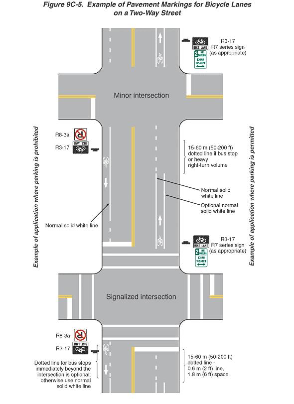
16 On Street Bikeways On-street bicycle facilities include a range of shared roadways, paved shoulders, signed routes and bike lanes. The existing design guidelines in New York State allow communities and regions to implement the appropriate features to meet local conditions. Examples of these treatments are illustrated below. The NYS MUTCD is adopting the Share the Road signs as shown in the federal manual (top left). The bicycle symbols can be used in dedicated bike lanes (as shown in the US MUTCD, right), or as pavement markings along bicycle routes (bottom left, Bronx NY, photo: J. Olson) to indicate correct lane position and direction of travel for both motorists and bicyclists. Note that while NY State and USDOT Guidelines provide good information on typical features, excellent sources are also available on which design to choose for a specific roadway based on local conditions. Fortunately, the Pedestrian and Bicycle Information Clearinghouse provides both a Facility Selection Guide and a Bike Lane Design Guide. These documents are available on line at 147
.")
.")
17 Bicycle Lanes and Signals The US MUTCD now includes a standard symbol for marking the spot where a bicyclist should stand to activate a traffic signal sensor (US MUTCD figure 9C-7, top right Boulder, CO, photo: J. Olson). At Herald Square in New York City, Dutch style bicycle signals are provided in the bicycle lanes (bottom right photo: J. Olson). The US MUTCD includes detailed examples of bike lane markings and signage (top left and next page). 148
18 149

19 Typical Width of Bicycle Facilities As noted previously, facilities for bicyclists can include a range of on-road facilities, such as shared roadways, paved shoulders, bike routes and bike lanes, as well as off-road facilities. Shared roadways and paved shoulders that are not marked for bicycling are also referred to as Class III facilities. Marked bike lanes and bike routes are also known as Class II facilities, and off-road facilities are also referred to as Class I facilities. On-Street Facilities When designing on-street bicycle facilities, it is typically suggested that the width of the facility be no less than 4 feet. According to the ITE Transportation Planning Handbook, A few extra feet of paved roadway shoulder can greatly benefit bicycle travel as little as three feet of smoothly paved shoulder to the right of the edge line can enable the bicyclist to move out of the travel lane, given that this area does not include rumble strips, which make the shoulder impassable for bicyclists. Paved shoulders of four to six feet in width are preferred. 105 There are several additional benefits to paved shoulders, such as added safety and easier maintenance. For a larger listing of benefits, see Reasons for Highway Shoulders and Benefits of Urban Bike Lanes to Other Road Users as prepared by Michael Ronkin (located at the end of the Recommendations Appendix). Bike lane widths should also be a minimum of 4 feet, according to the AASHTO Guide for the Development of Bicycle Facilities. 106 The City of Syracuse created its first bicycle lanes along both sides of Comstock Avenue between Colvin Street and Stratford Street in the City of Syracuse in Fall 2001 (see photo to the right) The 4-foot wide bike lanes are designated through a series of pavement markings stating Bike Only at various increments along the lanes. In addition, steel posted signs indicating Bike Lane Starts and Bike Lane Ends exist at both intersections in both directions. See section 3.2 for more details on the Comstock Avenue bike lane. For more information on on-street bicycle facilities, please go to the Design and Engineering page of the Pedestrian and Bicycling Information Center ( and click on On-Street Facilities. 105 John D. Edwards (ed.), ITE Transportation Planning Handbook, Institute of Transportation Engineers, Washington, D.C., 2d edition, 1999, p AASHTO Task Force on Geometric Design, Guide for the Development of Bicycle Facilities, American Association of State Highway and Transportation Officials, Washington, D.C., 1999, p
20 Off-Road Facilities When designing off-road facilities (also referred to as shared use paths, trails, bike paths, or Class I facilities) 10 feet or 3 meters is the recommended width for a two-way shared use path on a separate right of way. 107 Although off-road facilities are typically considered to be the most safe for bicyclists and pedestrians (particularly for children and family use), shared use paths are an addition, and complimentary, to the roadway network: they are not a substitute for providing access to streets and highways. Even the most extensive trail network cannot provide access to all the origins and destinations in a community, and trail users have to be able to get to and from the trail on the regular street network. 108 The AASHTO Guide for the Development of Bicycle Facilities specifically notes that, "shared use paths should not be used to preclude on-road bicycle facilities but rather to supplement a system of on-road bike lanes, wide outside lanes, paved shoulders and bike routes." 109 There are several other critical factors concerning trail design, which can be found at (go to the Design and Engineering page and click on Shared Use Paths). 107 Pedestrian and Bicycle Information Center, Shared Use Paths (Trails): Design Details, 12/15/04, < 108 Pedestrian and Bicycle Information Center, Shared Use Paths (Trails): Introduction, 12/15/04, < 109 AASHTO Task Force on Geometric Design, Guide for the Development of Bicycle Facilities, American Association of State Highway and Transportation Officials, Washington, D.C., 1999, p

21 Bicycle Regulatory Signs Just as there are regulations for motorists, there are regulations for bicyclists and appropriate signage to indicate legal roadway behavior. The following section from Part 9 of the US MUTCD illustrates the range of signage which can be applied to encourage bicyclists and motorists to ride in the proper direction, obey traffic controls and share roads and trails with other users. 152

.")
 and enable the user to lock the frame and wheels of the bike with a cable or U-shaped lock.")
22 Bicycle Parking and Amenities Travel by bicycle is similar in many ways to driving a car you need safe routes to travel on, secure parking at the end of your trip, and amenities to make your trip enjoyable. Like streetscape design, these features are generally not detailed in the Highway Design Manual, MUTCD or AASHTO Guide. Fortunately, there are excellent resources available, and they can be used with creativity to provide excellent solutions. One of the best resources for bicycle parking guidelines is available on-line from the Association of Pedestrian and Bicycle Professionals (APBP). The Pedestrian and Bicycle Information Center describes the basics of bicycle parking as follows: Bicycle parking needs to be visible, accessible, easy to use, convenient, and plentiful. Racks need to support the whole bike (not just one wheel) and enable the user to lock the frame and wheels of the bike with a cable or U-shaped lock. Parking should preferably be covered, well lit, and in plain view without being in the way of pedestrians or motor vehicles. The APBP bicycle parking guidelines are available online at: Bicycle parking can be easily customized to provide functional, context sensitive solutions. These examples show how local Syracuse icons can be easily integrated into standard bike racks (APBP Bicycle Parking Guide cover, left; Graphics, right: J. Olson). 153
, and others (see the Existing Conditions portions of this document for more detail).")

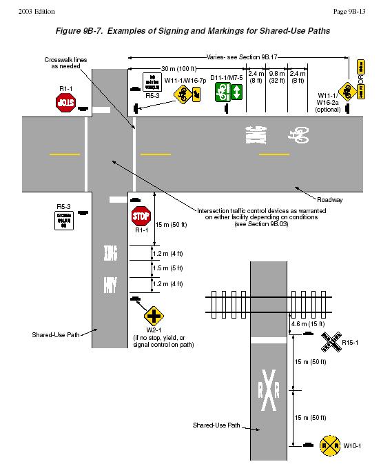
23 7.2.3 Greenways and Trails The SMTC region s developing greenway and trail system includes the Onondaga Lake Trail, the Onondaga Creekwalk, the Erie Canalway Trail, Bear Trap Creek trail (along a portion of I- 81), and others (see the Existing Conditions portions of this document for more detail). Basic guidance for trail width, surfaces, geometric design, safety signage and pavement markings is included in the MUTCD, the AASHTO Guide, and the Highway Design Manual. Creativity and context-sensitive design can be applied to features such as historical interpretation, mile markers, gateways, overlooks, rest stops, benches and other amenities. Valuable resources for these features are available online from Parks and Trails New York at The MUTCD, AASHTO and NYSDOT guidelines can provide trail geometry (top left graphic) and safety signage (graphic, next page). Local conditions can be expressed in the design of trail features and amenities that make each trail a unique experience. Local history and art can be integrated into greenways and trails, as shown along the Erie Canal Trail (bottom left photo: J. Olson.). 154
24 155

 1.")
; Paved shoulders are a good solution for pedestrians and bicyclists in rural and suburban areas (top right graphic: J.")
25 7.2.4 Innovative Treatments There are a number of ways in which design guidelines can be combined with engineering judgment that provide innovative solutions based on existing design guidelines. The guidelines provided by the MUTCD and Highway Design manual are not intended to show every possible condition, and in many cases can be used with flexibility. The following examples show how guidelines can be used as the basis of innovative treatments for pedestrians and bicyclists. BEFORE: 4.8 m (16 ) AFTER: 4.8 m (16 ) 1.8 m (5 ) 1.8 m (5 ) 3.3 m (11 ) 3.3 m (11 ) 1.8 m (5 ) Suburban Section with Paved Shoulders (a potential alternative to sidewalks) The bicycle box advanced stop marking allows cyclists to queue in front of motorists at intersections (bottom left - Cambridge, England, photo: J. Olson); Paved shoulders are a good solution for pedestrians and bicyclists in rural and suburban areas (top right graphic: J. Olson); Adopt a Highway programs can be used for bicycle routes, as shown along Bike Route 17 near Binghamton, NY (top left photo: L. Rossi) and Dutch Stairways can be provided to accommodate bicyclists and pedestrians (bottom right graphic: Oregon DOT Bicycle and Pedestrian Plan). 156


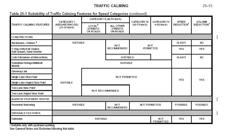
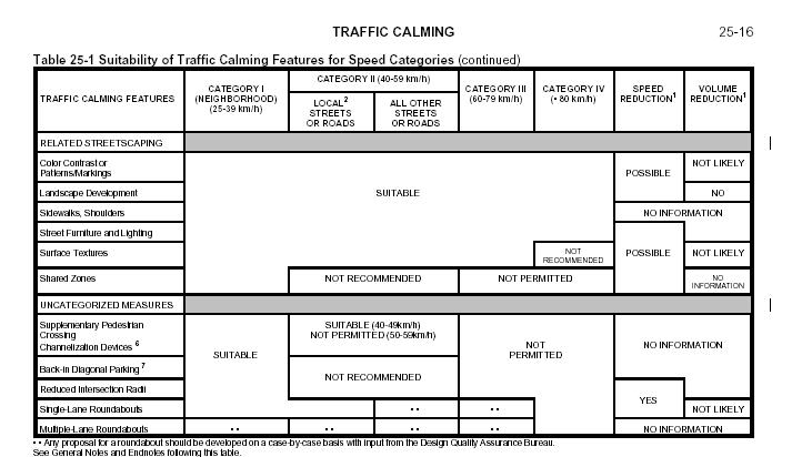
26 7.2.5 Traffic Calming Traffic calming provides street designs that balance the needs of pedestrians, bicyclists and motorists. The MUTCD and NYS Highway Design Manuals have both been updated recently to include a variety of traffic calming features including speed humps, raised crossings, roundabouts, curb neckdowns and other devices. The NYSDOT Highway Design Manual includes a new Chapter 25: Traffic Calming, which provides guidelines on selecting traffic calming features for use on state and local roads. The facility selection tables are provided on the following page. Examples of traffic calming features that are included in the manuals are shown below. Speed tables (top left) and Roundabouts (bottom left) are illustrated in the US MUTCD; curb neckdowns for both intersection and midblock conditions (right) are detailed in NYSDOT Chapter
27 158


.")

28 7.2.6 School Zones Children are dependent on walking and bicycling as their only independent means of transportation. There is a growing movement to create Safe Routes to Schools so that the areas around our schools are safe places to walk and bicycle (see Action Item P6 in Appendix A for more details on the Safe Route to Schools program). Bicycle, pedestrian and traffic calming improvements are part of the solution. The MUTCD Part 7: Traffic Controls for School Areas, provides a wide range of school zone safety signs and pavement markings, as illustrated below. 159
29 7.3 Additional Resources The primary documents referred to in this document are the basic guidelines for developing bicycle and pedestrian improvements in the SMTC region. There are a growing number of innovative design guidelines that go beyond the basic information included in State and Federal manuals. In many cases, these following documents and resources are useful in providing innovative solutions for local communities. NYBC The New York Bicycling Coalition (NYBC) provides an online guide called Improving Bicycling & Pedestrian Safety in New York State. This resource provides case studies, photo files and tools for creating bicycle-friendly communities. The NYBC also offers several pedestrian related planning tools. Website: PTNY Parks & Trails New York (PTNY) is a great resource for developing Greenways and Trails. Their website includes an online guide for local communities, as well as a variety of tools for getting greenways on the ground in New York State. Website: Pedestrian and Bicycle Information Center Design and Engineering Designers and engineers have a diverse array of design elements and ever-developing technologies at their disposal. Use this section of the web site as a source for information on the design and engineering tools that promote bikeability. Excellent bicycle lane and bicycle parking design guidelines are available from this source. Design and Engineering This site provides engineering treatments for pedestrians as they relate to pedestrian facility design, roadway design, intersection design, traffic calming, traffic management and signals and signs. The Oregon Bicycle and Pedestrian Plan This document is the planning and design manual for pedestrian and bicycle transportation in Oregon. It is published by the Oregon Bicycle and Pedestrian Program and was adopted by the Oregon Transportation Commission on June 14, The standards and designs shown in the plan are ODOT standards used on State Highway projects. These standards meet or exceed national standards as outlined in AASHTO (American Association of State Highway Transportation Officials) documents, the ADAAG (Americans with Disabilities Act Accessibility Guidelines) and other documents. These standards are recommended but not required for use by local jurisdictions in Oregon. Website: 160
INDOT Complete Streets Guideline & Policy
 INDOT Complete Streets Guideline & Policy INTRODUCTION The Complete Streets guidelines build upon multiple efforts and promote a multimodal transportation system that is integrated and sustains land use
APPENDIX A: Complete Streets Checklist DRAFT NOVEMBER 2016
 APPENDIX A: Complete Streets Checklist DRAFT NOVEMBER 2016 Complete Streets Checklist MetroPlan Orlando s Complete Streets Checklist is an internal planning tool for staff to further implementation of
Off-road Trails. Guidance
 Off-road Trails Off-road trails are shared use paths located on an independent alignment that provide two-way travel for people walking, bicycling, and other non-motorized users. Trails specifically along
REGIONAL BICYCLE AND PEDESTRIAN DESIGN GUIDELINES
 REGIONAL BICYCLE AND PEDESTRIAN DESIGN GUIDELINES November 16, 2011 Deb Humphreys North Central Texas Council of Governments Bicycle and Pedestrian Advisory Committee Snapshot of the Guide 1. Introduction
General Design Factors
 Chapter 3: 3-1.0 Introduction General Design Factors Mn/DOT s goals include encouraging and accommodating safe bicycling. From a design perspective, these goals are achieved by first having an understanding
Appendix C. Bicycle Route Signage
 Appendix C Bicycle Route Signage This page intentionally left blank. APPENDIX C - BICYCLE ROUTE AND WAYFINDING SIGNAGE Bicycle route signs are wayfinding signs that guide bicyclists along preferred, designated
Proposed. City of Grand Junction Complete Streets Policy. Exhibit 10
 Proposed City of Grand Junction Complete Streets Policy Exhibit 10 1 City of Grand Junction Complete Streets Policy Vision: The Complete Streets Vision is to develop a safe, efficient, and reliable travel
What Is a Complete Street?
 Session 5 Charleen Zimmer, AICP, Zan Associates May 5-7, 2010 What Is a Complete Street? May 2010 5-1 Not a Complete Street More of a Complete Street May 2010 5-2 Benefits of Complete Streets Safety for
Connecting cyclists to work. Syracuse Metropolitan Transportation Council
 Connecting cyclists to work Syracuse Metropolitan Transportation Council Overview Prepared at request: NYS Department of Transportation (NYSDOT) Project Achievements Target group Purpose Process Recommendations
ACTIVE TRANSPORTATION
 ACTIVE TRANSPORTATION Mobility 2040 Supported Goals Improve the availability of transportation options for people and goods. Support travel efficiency measures and system enhancements targeted at congestion
Gordon Proctor Director Policy on Accommodating Bicycle and Pedestrian Travel on ODOT Owned or Maintained Facilities
 Approved: Policy: 20-004(P) Responsible Office: Planning Gordon Proctor Director Policy on Accommodating Bicycle and Pedestrian Travel on ODOT Owned or Maintained Facilities I. POLICY STATEMENT: This policy
NJDOT Complete Streets Checklist
 Background The New Jersey Department of Transportation s Complete Streets Policy promotes a comprehensive, integrated, connected multi-modal network by providing connections to bicycling and walking trip
CURBSIDE ACTIVITY DESIGN
 5 CURBSIDE ACTIVITY DESIGN This chapter provides design guidance for separated bike lanes adjacent to curbside activities including parking, loading and bus stops. Typical configurations are presented
Agenda. Overview PRINCE GEORGE S PLAZA METRO AREA PEDESTRIAN PLAN
 PRINCE GEORGE S PLAZA METRO AREA PEDESTRIAN PLAN May 28, 2008 Agenda Welcome and introductions Project overview and issue identification Planning context and strengths Design challenges and initial recommendations
City of Albert Lea Policy and Procedure Manual 4.10 ALBERT LEA CROSSWALK POLICY
 4.10 ALBERT LEA CROSSWALK POLICY PURPOSE: Pedestrian crosswalks are an integral part of our transportation infrastructure. To be effective and promote safety, marked crosswalks must be installed after
TOWN OF PORTLAND, CONNECTICUT COMPLETE STREETS POLICY
 TOWN OF PORTLAND, CONNECTICUT COMPLETE STREETS POLICY I. VISION, GOALS & PRINCIPLES VISION To improve the streets of Portland making them safer and more accessible for all users including pedestrians,
Appendix 3 Roadway and Bike/Ped Design Standards
 Appendix 3 Roadway and Bike/Ped Design Standards OTO Transportation Plan 2040 4/20/2017 Page A3-1 Adopted Standards The adopted OTO Design Standards and Major Thoroughfare Plan are contained herein.
Hennepin County Pedestrian Plan Public Comment Report
 Hennepin County Pedestrian Plan Public Comment Report On May 31, 2013, the draft Hennepin County Pedestrian Plan was released for a 45-day public comment period ending July 15, 2013. The county received
OBJECTIVE: Improve safety by designing all bicycle facilities to the latest AASHTO bicycle guidelines and 2009 MUTCD Standards.
 DESIGN AND APPLICATION OF GUIDELINES AND STANDARDS The Citizen Advisory and Technical Advisory Committees identified improving safety by providing consistent bicycle facilities throughout the region as
2018 AASHTO BIKE GUIDE
 2018 AASHTO BIKE GUIDE Your presenter Rob Burchfield, PE NW Regional Engineering Director 35 years of experience in traffic engineering and bicycle facility design Toole Design Group Toole Design Group
10.0 CURB EXTENSIONS GUIDELINE
 10.0 CURB EXTENSIONS GUIDELINE Road Engineering Design Guidelines Version 1.0 March 2017 City of Toronto, Transportation Services City of Toronto Page 0 Background In early 2014, Transportation Services
CITY OF SARATOGA SPRINGS PEDESTRIAN CROSSING TOOLBOX
 CITY OF SARATOGA SPRINGS PEDESTRIAN CROSSING TOOLBOX This toolbox is to be used to guide pedestrian crossing improvements within the City of Saratoga Springs. Details for each crossing type are provided.
Omaha s Complete Streets Policy
 Omaha s Complete Streets Policy (Adopted August 2015) VISION To create great places and enhance our quality of life, the City of Omaha will provide safe, accessible streets for all users. Complete Streets
900 BICYCLE FACILITIES Traffic Engineering Manual
 TABLE OF CONTENTS Part 9 - BICYCLE FACILITIES 900 GENERAL... 9-3 900-1 General Background... 9-3 900-2 Designated Bicycle Routes... 9-3 901 SIGNINGS... 9-4 902 MARKINGS... 9-4 902-1 General... 9-4 902-2
Appendix T CCMP TRAIL TRAFFIC & TRANSPORTATION DESIGN STANDARD
 Appendix T CCMP 3.3.4 TRAIL TRAFFIC & TRANSPORTATION DESIGN STANDARD 3.3.4 Trail Traffic and Transportation Design Multi-use trails have certain design standards, which vary depending on the agency that
Steps to Conducting a Complete Streets Assessment
 Steps to Conducting a Complete Streets Assessment Familiarize yourself with Complete Streets Read through the Complete Streets Assessment Guidelines. This will give you an idea of what Complete Streets
900 BICYCLE FACILITIES Traffic Engineering Manual
 TABLE OF CONTENTS Part 9 - BICYCLE FACILITIES 900 GENERAL... 9-3 900-1 General Background... 9-3 900-2 Designated Bicycle Routes... 9-3 901 SIGNING... 9-4 901-1 General... 9-4 901-2 Bicycle 3-Foot Clearance
Active Transportation Facility Glossary
 Active Transportation Facility Glossary This document defines different active transportation facilities and suggests appropriate corridor types. Click on a facility type to jump to its definition. Bike
Cycle Track Design Best Practices Cycle Track Sections
 Design Best Practices Sections It is along street segments where the separation and protection methods of cycle tracks offer more comfort than conventional bicycle lanes, and are more attractive to a wide
Who is Toole Design Group?
 2018 AASHTO Bike Guide Status Update NCHRP 15 60 Amalia Leighton Cody, PE, AICP & Kenneth Loen, PE Washington APWA October 4, 2018 Who is Toole Design Group? TDG is a full service engineering, planning
A. Pedestrian Facility Design
 A. Pedestrian Facility Design Photo by Dan Burden Photo by Cara Seiderman Walkways are the portion of the public right-of-way that provide a separated area for people traveling on foot.walkways that are
Chapter 3 DESIGN SPECIFICATIONS
 Brampton PathWays Planning and Design Guidelines 27 Chapter 3 DESIGN SPECIFICATIONS 3.1 CLASS 1 MULTI-USE PATH Off-road multi-use trails are the backbone of the Brampton PathWays Network. They are typically
AMATS Complete Streets Policy
 AMATS Complete Streets Policy Table of Contents: Section 1. Definition of Complete Streets Section 2. Principles of Complete Streets Section 3. Complete Streets Policy Section 4. Consistency Section 5.
CHAPTER 1 STANDARD PRACTICES
 CHAPTER 1 STANDARD PRACTICES OBJECTIVES 1) Functions and Limitations 2) Standardization of Application 3) Materials 4) Colors 5) Widths and Patterns of Longitudinal Pavement Marking Lines 6) General Principles
Document 2 - City of Ottawa Pedestrian Crossover (PXO) Program
 Program") 40 Document 2 - City of Ottawa Pedestrian Crossover (PXO) Program OVERVIEW The City of Ottawa Pedestrian Crossover (PXO) Program provides the basis for PXO implementation in Ottawa. The program s processes
40 Document 2 - City of Ottawa Pedestrian Crossover (PXO) Program OVERVIEW The City of Ottawa Pedestrian Crossover (PXO) Program provides the basis for PXO implementation in Ottawa. The program s processes
CHAPTER 16 PEDESTRIAN FACILITIES DESIGN AND TECHNICAL CRITERIA TABLE OF CONTENTS
 CHAPTER 16 PEDESTRIAN FACILITIES DESIGN AND TECHNICAL CRITERIA TABLE OF CONTENTS Section Title Page 16.1 General... 16-1 16.1.1 AASHTO Reference... 16-1 16.1.2 ADA Requirements... 16-1 16.2 Sidewalks...
The 2009 Manual on Uniform Traffic Control Devices (MUTCD) (Brief) Highlights for Arizona Practitioners. Arizona Department of Transportation
 (Brief) Highlights for Arizona Practitioners. Arizona Department of Transportation") The 2009 Manual on Uniform Traffic Control Devices (MUTCD) (Brief) Highlights for Arizona Practitioners Arizona Department of Transportation New 2009 MUTCD 9 Parts (down from 10 in 2003) 816 pages (up
The 2009 Manual on Uniform Traffic Control Devices (MUTCD) (Brief) Highlights for Arizona Practitioners Arizona Department of Transportation New 2009 MUTCD 9 Parts (down from 10 in 2003) 816 pages (up
TRAFFIC CONTROLS FOR BICYCLE FACILITIES
 PART IX. TRAFFIC CONTROLS FOR BICYCLE FACILITIES A. GENERAL 9A-1 Requirements for Bicyclist Traffic Control Devices Traffic control devices, whether they are intended for motorists or bicyclists, must
PEDESTRIAN ACCOMMODATIONS DPS 201 AT ROUNDABOUTS
 PEDESTRIAN ACCOMMODATIONS DPS 201 AT ROUNDABOUTS WHY THEY WORK FOR PEDESTRIANS IF DESIGNED CORRECTLY Separated sidewalks direct peds to crosswalks Splitter island Slow speed exit Truck apron Crosswalk
Living Streets Policy
 Living Streets Policy Introduction Living streets balance the needs of motorists, bicyclists, pedestrians and transit riders in ways that promote safety and convenience, enhance community identity, create
Chapter 4 TOOLBOX AND SAMPLE BIKE BOULEVARD LAYOUT
 Chapter 4 TOOLBOX AND SAMPLE BIKE BOULEVARD LAYOUT OVERVIEW This chapter describes a cohesive set of strategies to create a bicycle boulevard, namely to make streets safer and more efficient for bicycle
ADA & Public Rights of Way
 ADA & Public Rights of Way Overview of Current and Up-coming Requirements FDOT Design Training Expo 2012 Orlando, FL Dean Perkins, RA - ADA Coordinator Florida Department of Transportation Office of Design,
The 2012 AASHTO Bike Guide: An Overview
 The 2012 AASHTO Bike Guide: An Overview Presentation by: Jennifer Toole, AICP, ASLA Peter Lagerwey August 10, 2012 {Enter Module Name on Master Slide} WEBINAR #1: OVERVIEW OF 2012 AASHTO BIKE GUIDE Today
o n - m o t o r i z e d transportation is an overlooked element that can greatly enhance the overall quality of life for the community s residents.
 N o n - m o t o r i z e d transportation is an overlooked element that can greatly enhance the overall quality of life for the community s residents. 84 Transportation CHAPTER 11 INTRODUCTION Transportation
Broad Street Bicycle Boulevard Design Guidelines
 Broad Street Bicycle Boulevard Design Guidelines Building from the strategies introduced in the 2013 Bicycle Transportation Plan and community input received thus far, City Transportation Staff have identified
Evolving Roadway Design Policies for Walking and Bicycling
 Evolving Roadway Design Policies for Walking and Bicycling The 2016 Michigan Transportation Planning Conference Kalamazoo, MI July 13, 2016 Title 23 of the Code of Federal Regulations Title 23 was originally
PEDESTRIAN SAFETY IMPROVEMENT EVALUATION GUIDELINE FOR UNCONTROLLED CROSSINGS
 PEDESTRIAN SAFETY IMPROVEMENT EVALUATION GUIDELINE FOR UNCONTROLLED CROSSINGS Traffic Safety Engineering Division Updated: April 2018 EXECUTIVE SUMMARY NDOT Traffic Safety Engineering Division developed
Off-Road Facilities Part 1: Shared Use Path Design
 Off-Road Facilities Part 1: Shared Use Path Design Presentation by: Eric Mongelli, P.E. Tom Huber October 9, 2012 FOLLOW THE CONVERSATION ON TWITTER Toole Design Group is live tweeting this webinar @tooledesign
Zlatko Krstulich, P.Eng. City of O9awa
 Zlatko Krstulich, P.Eng. City of O9awa 1. Introduction to the Ontario Traffic Manual Series 2. What is OTM Book 18: Bicycle Facilities? 3. Study / Committee Team Members 4. Brief overview of the content
Appendix D. City of Fort Collins Bicycle Wayfinding System Guidance. Appendix D: Bicycle Wayfinding System Guidance Final Draft 11/20/2014 1
 Appendix D City of Fort Collins Bicycle Wayfinding System Guidance Appendix D: Bicycle Wayfinding System Guidance Final Draft 11/20/2014 1 1 -- Introduction A network of signed bicycle routes will contribute
2018 AASHTO BIKE GUIDE
 2018 AASHTO BIKE GUIDE Your presenters Jessica Fields, PE Denver Office Director Sagar Onta, PE, PTOE Denver Engineering Director 35 years of combined experience street design, transportation planning,
2.0 LANE WIDTHS GUIDELINE
 2.0 LANE WIDTHS GUIDELINE Road Engineering Design Guidelines Version 2.0.1 May 2018 City of Toronto, Transportation Services City of Toronto Page 0 Background In early 2014, Transportation Services initiated
INDEX. Geometric Design Guide for Canadian Roads INDEX
 Acceleration lane, see Lanes, Acceleration Access, 8.1 Access Management and Functional Classification 8.2 Access Management by Design Classification 8.3 Access Configuration 8.4 Building Set-Back Guidelines
MnDOT Implementation of Complete Streets Policy. January 2014
 MnDOT Implementation of Complete Streets Policy January 2014 1 Prepared by Minnesota Department of Transportation 395 John Ireland Boulevard Saint Paul, Minnesota 55155-1899 Phone: 651-296-3000 Toll-Free:
MAG Town of Cave Creek Bike Study Task 6 Executive Summary and Regional Significance Report
 Page 1 MAG Town of Cave Creek Bike Study Task 6 Executive Summary and Regional Significance Report August 1, 2012 MAG Project #481 Page 2 Task 6 Executive Summary and Regional Significance Report Introduction
PRINCE GEORGE S PLAZA METRO AREA PEDESTRIAN PLAN
 PRINCE GEORGE S PLAZA METRO AREA PEDESTRIAN PLAN May 28, 2008 Agenda Welcome and introductions Project overview and issue identification Planning context and strengths Design challenges and initial recommendations
On Road Bikeways Part 1: Bicycle Lane Design
 On Road Bikeways Part 1: Bicycle Lane Design Presentation by: Nick Jackson Bill Schultheiss, P.E. September 04, 2012 FOLLOW THE CONVERSATION ON TWITTER Toole Design Group is live tweeting this webinar
PART 9. TRAFFIC CONTROLS FOR BICYCLE FACILITIES TABLE OF CONTENTS
 2006 Edition Page TC9-1 PART 9. TRAFFIC CONTROLS FOR BICYCLE FACILITIES TABLE OF CONTENTS SECTIONS CHAPTER 9A. Section 9A.01 Section 9A.02 Section 9A.03 Section 9A.04 Section 9A.05 Section 9A.06 Section
Bicyclist Signing Guidelines
 Bicyclist Signing Guidelines April, 2009 1 Introduction This paper describes the Montana Department of Transportation s (MDT) current practices related to bicyclist safety and signing issues and presents
Complete Streets for Louisiana
 Complete Streets for Louisiana Louisiana Transportation Conference 2011 Ellen W. Soll, AICP Planner Burk-Kleinpeter, Inc esoll@bkiusa.com 504.486.5901 x143 What is a Complete Street? What are Complete
Task 4 Wayfinding Elements, Placement and Technical Guidance 4.1 Wayfinding Elements
 1836 Blake Street Denver, CO 80202 720.524.7831 ww.altaplanning.com MEMO 3 Task 4 Wayfinding Elements, Placement and Technical Guidance 4.1 Wayfinding Elements Based on field reconnaissance, best practices
Morristown, NJ Complete Streets Policy
 Morristown, NJ Complete Streets Policy Introduction A Complete Street is defined as a means to provide safe access for all users by designing and operating a comprehensive, integrated, connected multi-modal
DISTRIBUTION: Electronic Recipients List TRANSMITTAL LETTER NO. (17-01) MINNESOTA DEPARTMENT OF TRANSPORTATION. MANUAL: Road Design English Manual
 MINNESOTA DEPARTMENT OF TRANSPORTATION. MANUAL: Road Design English Manual") DISTRIBUTION: Electronic Recipients List MINNESOTA DEPARTMENT OF TRANSPORTATION DEVELOPED BY: Design Standards Unit ISSUED BY: Office of Project Management and Technical Support TRANSMITTAL LETTER NO.
DISTRIBUTION: Electronic Recipients List MINNESOTA DEPARTMENT OF TRANSPORTATION DEVELOPED BY: Design Standards Unit ISSUED BY: Office of Project Management and Technical Support TRANSMITTAL LETTER NO.
Complete Streets Successes, Opportunities, and Challenges
 Complete Streets Successes, Opportunities, and Challenges Juliet Walker, Transportation Planner, City of Portsmouth Rob Houseman, Director of Planning and Development, Town of Wolfeboro Chris Parker, Director
Small Town & Rural Multimodal Networks
 Small Town & Rural Multimodal Networks Fred Young, PLA Andrea Clinkscales, AICP, PMP Alta Planning + Design Funding Partners Project Team Existing Design Guidance AASHTO Flexibility Guide 2004 AASHTO Bike
Chapter 5: Crossing the Street
 Chapter 5: Crossing the Street Whether walking or bicycling, a student s journey to school will more than likely require crossing one or more streets. Per the Safe Routes to School Guide, maintained by
MUTCD Part 6: Temporary Traffic Control
 MUTCD Part 6: Temporary Traffic Control OMUTCD English units are preferred. OHIO MANUAL OF UNIFORM TRAFFIC CONTROL DEVICES TABLE OF CONTENTS PREFACE INTRODUCTION TABLE OF CONTENTS PART 1. GENERAL Chapter
MINNEAPOLIS PARK & RECREATION BOARD DRAFT TRAIL DESIGN STANDARDS FOR: SIGNS AND PAVEMENT MARKINGS
 MINNEAPOLIS PARK & RECREATION BOARD DRAFT TRAIL DESIGN STANDARDS FOR: SIGNS AND PAVEMENT MARKINGS October 14, 2014 CHANGE LOG Additions and changes to this document should be summarized on this page and
Roadway Classification Design Standards and Policies. Pueblo, Colorado November, 2004
 Roadway Classification Design Standards and Policies Pueblo, Colorado November, 2004 Table of Contents Page Chapter 1. General Provisions 1.1 Jurisdiction 3 1.2 Purpose and Intent 3 1.3 Modification 3
South Carolina Department of Transportation. Engineering Directive
 South Carolina Department of Transportation Engineering Directive Directive Number: ED-22 Effective: December 16, 2009 Subject: References: Purpose: This Directive Applies to: Considerations for Bicycle
March 2008 FINAL DRAFT. Supplemental Bikeway Design Guidelines
 March 2008 FINAL DRAFT Supplemental Bikeway Design Guidelines Prepared for: Marin County Department of Public Works Marin County Unincorporated Area Bicycle and Pedestrian Master Plan Prepared by: Alta
APPROVE A RESOLUTION ADOPTING A COMPLETE STREETS POLICY
 STAFF REPORT MEETING DATE: September 13, 2016 TO: FROM: City Council Bob Brown, Community Development Director Russ Thompson, Public Works Director Patrick Filipelli, Management Analyst 922 Machin Avenue
Table of Contents Introduction. 2 Purpose of the Plan...2 The Benefits of Walking and Bicycling...3 Vision and Goals of the Plan...
 BICYCLE AND This plan was created through a grant from the Healthy Communities Program with the cooperation of the City of Cynthiana, Cynthiana Main Street, Cynthiana-Harrison County-Berry Joint Planning
Coquitlam Cross-town Bike Route Improving Bicycle Facilities in a Mature Suburban Environment
 Coquitlam Cross-town Bike Route Improving Bicycle Facilities in a Mature Suburban Environment Sarah Rocchi, Vice-President, Projects, Opus International Consultants (Main Presenter) Catherine Mohoruk,
PURPOSE AND POLICY GUIDANCE
 1 PURPOSE AND POLICY GUIDANCE The VTA Bicycle Technical Guidelines (BTG) present standards and guidance for planning, designing, operating, retrofitting and maintaining roadways and bikeways. They are
Section 9A.07 Meaning of Standard, Guidance, Option, and Support
 2012 Edition Page 895 PART 9. TRAFFIC CONTROLS FOR BICYCLE FACILITIES CHAPTER 9A. GENERAL Section 9A.01 Requirements for Bicyclist Traffic Control Devices 01 General information and definitions concerning
Bowman-Melton Associates, Inc. june 2011
 2011 dallas bike plan ADDENDUM Bowman-Melton Associates, Inc. Complete Streets Initiative Design and policy guidance june 2011 2 2011 Dallas Bike Plan Complete Streets Initiative Design and Policy Guidance
Appendix C. TRAFFIC CALMING PROGRAM TOOLBOX
 Appendix C. TRAFFIC CALMING PROGRAM TOOLBOX PHASE I...2 Do Not Enter Sign...3 One-Way Sign...4 Turn Prohibition...5 Pavement Markings...6 Speed Monitoring Trailer...7 Neighborhood Speed Watch...8 Police
Pedestrian Crossing Guidelines 2016
 Pedestrian Crossing Guidelines 2016 Engineering Services 1.0 Introduction and Background The City of Kingston s first Pedestrian Crossing Guidelines were approved by Council in 2008 in order to provide
City of Saline. Complete Streets Ordinance
 City of Saline Complete Streets Ordinance September 13 and 20, 2010 CARLISLE/WORTMAN ASSOCIATES What Are Complete Streets? Complete streets are designed to serve everyonemotorists as well as pedestrians
Section 3A.04 Colors. Section 3B.10 Approach Markings for Obstructions
 Section 3A.04 Colors Markings shall be yellow, white, red, or blue, or purple. The colors for markings shall conform to the standard highway colors. Black in conjunction with one of the above colors shall
Watertown Complete Streets Prioritization Plan. Public Meeting #1 December 14, 2017
 Watertown Complete Streets Prioritization Plan Public Meeting #1 December 14, 2017 Goals for Public Meeting Overview of MassDOT Complete Streets Funding Program Educate the community on Complete Streets
Chapter 2: Standards for Access, Non-Motorized, and Transit
 Standards for Access, Non-Motorized, and Transit Chapter 2: Standards for Access, Non-Motorized, and Transit The Washtenaw County Access Management Plan was developed based on the analysis of existing
What's in the 2012 California MUTCD for Pedestrians, Bicyclists, and School Areas?
 What's in the 2012 California MUTCD for Pedestrians, Bicyclists, and School Areas? CA MUTCD 2012 edits by John Ciccarelli Member, California Traffic Control Devices Committee Member, NCUTCD Bicycle Technical
Figure 3B-1. Examples of Two-Lane, Two-Way Marking Applications
 Figure 3B-1. Examples of Two-Lane, Two-Way Marking Applications A - Typical two-lane, two-way marking with passing permitted in both directions B - Typical two-lane, two-way marking with no-passing zones
Accommodating Pedestrians in the Work Zone
 Accommodating Pedestrians in the Work Zone Guidance for Section C Plan Preparers Some impacts cannot be avoided and those impacts apply to residents, businesses, motorists, and pedestrians alike. However,
MEMORANDUM. Date: 9/13/2016. Citywide Crosswalk Policy
 MEMORANDUM Date: 9/13/2016 Re: Citywide Crosswalk Policy Foreword Through the s Circulation Element and Complete Streets Policy, it is the City s goal to promote walking trips and provide safe facilities
Bike Planning: A New Day
 Bike Planning: A New Day Josh Sikich, AICP, LEED AP Chicago Office Director Alta Planning + Design 312-265-0628 joshuasikich@altaplanning.com cities of all sizes are changing Illinois Bike Summit October
ROUNDABOUTS/TRAFFIC CIRCLES
 GENERAL 1. Description This standard identifies minimum requirements that shall be met for Roundabouts and Neighborhood Traffic Circles in the design and construction of elements for Arlington County Horizontal
Roadway Design Manual
 Roadway Design Manual Manual Notice Archive by Texas Department of Transportation (512) 302-2453 all rights reserved Manual Notice 2009-1 From: Manual: Mark A. Marek, P.E Roadway Design Manual Effective
Non-Motorized Transportation 7-1
 Non-Motorized Transportation 7-1 Transportation facilities no longer mean just accommodating a vehicle powered by a combustion engine. Pedestrian and non-motorized facilities are important modes of travel
CITY OF BLOOMINGTON COMPLETE STREETS POLICY
 CITY OF BLOOMINGTON COMPLETE STREETS POLICY POLICY OBJECTIVE: The City of Bloomington will enhance safety, mobility, accessibility and convenience for transportation network users of all ages and abilities,
Multimodal Through Corridors and Placemaking Corridors
 68 Multimodal Through Corridors and Placemaking Corridors Corridors have different functions in a region. Some corridors are used to get smoothly and rapidly through a region or to get quickly to major
2012 by the American Association of State Highway and Transportation Officials. All rights reserved. Duplication is a violation of applicable law.
 Table of Contents Chapter 1: Introduction... 1-1 1.1 Design Imperative... 1-1 1.2 Purpose... 1-1 1.3 Scope... 1-2 1.4 Definitions... 1-2 Chapter 2: Bicycle Planning... 2-1 2.1 Background... 2-1 2.2 Why
 COMPLETE STREETS CHECKLIST City of Philadelphia The City of Philadelphia's Complete Streets policies are designed ensure that city streets are safe, comfortable and convenient for people of all ages and
UNCONTROLLED PEDESTRIAN CROSSING GUIDELINES
 City and County of Denver UNCONTROLLED PEDESTRIAN CROSSING GUIDELINES Prepared for: Prepared by: Adopted September 2016 This page is intentionally left blank. Contents for Denver Uncontrolled Pedestrian
Vision: Traditional hamlet with an attractive business/pedestrian friendly main street connected to adjacent walkable neighborhoods
 N D. Focus Area II Vision: Traditional hamlet with an attractive business/pedestrian friendly main street connected to adjacent walkable neighborhoods Transit Road Focus Area II is located in the Hamlet
Executive Summary Route 30 Corridor Master Plan
 Route Corridor Master Plan Project Overview The Route Corridor Master Plan is a coordinated multimodal transportation and land use plan for the entire stretch of Route through East Whiteland Township,
BIKE PLAN CONTENTS GATEWAY
 CONTENTS Acknowledgments...vii Great Rivers Greenway District Board of Directors... vii Great Rivers Greenway District Staff... vii Project Consultants... vii Committees... viii Citizens Advisory Committee
MANUAL ON UNIFORM TRAFFIC CONTROL DEVICES INTRODUCTION
 2011 Edition Page I-1 MANUAL ON UNIFORM TRAFFIC CONTROL DEVICES INTRODUCTION 01 Traffic control devices shall be defined as all signs, signals, markings, and other devices used to regulate, warn, or guide