Off-Road Facilities Part 1: Shared Use Path Design
|
|
|
- Hugo Hall
- 6 years ago
- Views:
Transcription

1 Off-Road Facilities Part 1: Shared Use Path Design Presentation by: Eric Mongelli, P.E. Tom Huber October 9, 2012

2 FOLLOW THE CONVERSATION ON TWITTER Toole Design Group is live tweeting this #AASHTO #BikeGuide
3 WEBINAR #5: OFF- ROAD FACILITIES PART 1: SHARED USE PATH DESIGN Today s Webinar Significant Expansion on Shared Use Path Design Basics Users, Purpose, Location Sidepaths Widths and Clearance Design Speed Alignment Slopes & Gradients Stopping Sight Distance Other Design Considerations
4 FUTURE WEBINARS August 10: Overview August 22: Planning Chapter September 4: On-Road Bikeways Part I Bike Lanes (including Intersections) September 18: On-Road Bikeways Part II Shared lanes Bicycle boulevards & signing Signals October 9: Shared Use Paths General design principles Pathway geometry October 23: Shared Use Paths Intersection Design Mid-block crossings November 6: Bikeway Maintenance and Operation
5 DISCOUNT FOR WEBINAR PARTICIPANTS AASHTO_Promo_Flyer.pdf Link will be ed to webinar attendees
6 SOME BACKGROUND What is AASHTO? Mission: provides technical services to support states in their efforts to efficiently and safely move people and goods Some history Last Guide 1999, largely written in Survey to update Guide Standards vs. guidance (Shall vs. should or may) Relationship between AASHTO Guide and the MUTCD Innovation vs. accepted practice
 2010 Highway Capacity Manual")
7 RELATIONSHIP TO OTHER MANUALS 2009 MUTCD FHWA 2011 AASHTO Green Book Public Right-of-Way Accessibility Guidelines (PROWAG) 2010 Highway Capacity Manual

8 AASHTO VS. NACTO GUIDE: EITHER/OR? AASHTO covers paths + onroad bikeways AASHTO covers design comprehensively AASHTO covers many but not all innovations NACTO is a source of information for solutions that are currently experimental

9 DESIGN GUIDANCE OF GREEN BOOK Share use path design generally follows principals of the Green Book Design speeds Horizontal & vertical curves Cross slopes Sight distances
10 ENGINEERING JUDGMENT The treatments described reflect typical situations; local conditions may vary and engineering judgment should be applied.

11 CHAPTER 5 DESIGN OF SHARED USE PATHS MAJOR CONTENT CHANGES New stand-alone chapter fills missing gaps in the old Guide New/Revised/Expanded Guidance on: Accessibility Sidepaths Widths, Shoulders and Safety Rails Design Speed Horizontal Alignment Speed Control Stopping Sight Distance Path/Roadway Intersections (discussed in next webinar)

12 INTRO TO SHARED USE PATHS Bikeways physically separated from motorized traffic Typically designed for two-way travel Supplement a network of on-road bike facilities

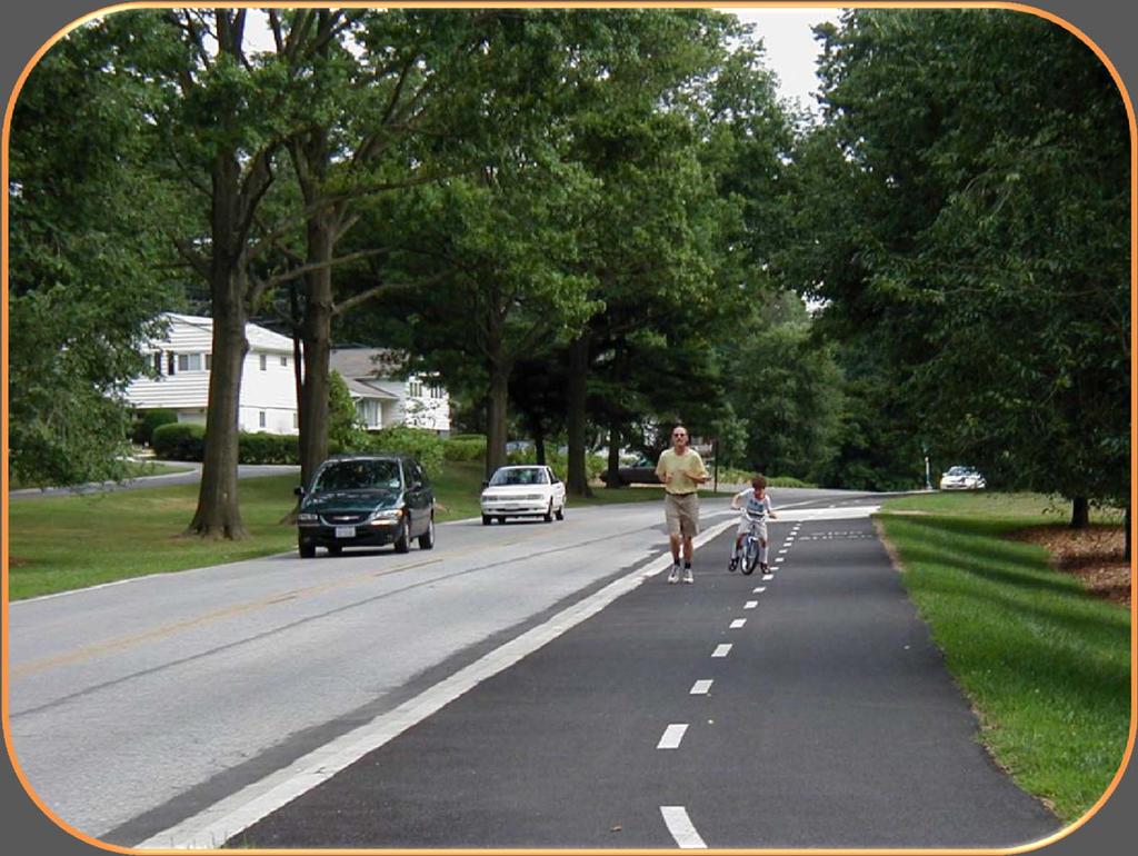
13 SHARED USE PATH USERS Bicyclists Upright adults, children Kick scooter users Recumbent & tandem users All others Bicyclists pulling trailers/bikes Pedestrians Walkers Runners Wheelchair users People with strollers People walking dogs Inline/roller skaters

14 USERS Motorized vehicles not recommended Can accommodate horses with an adjacent bridle trail

15 SHARED USE PATH LOCATIONS Abandoned or active railroad Rivers Lake and ocean fronts Canals Utility rights-of-way College campuses Roadway corridors called sidepaths

16 SHARED USE PATH LOCATIONS Lakes and Ocean Fronts Along Canals


17 SHARED USE PATH LOCATIONS Utility rights-of-way Rivers

18 SHARED USE PATH LOCATIONS College campuses Roadway corridors called sidepaths

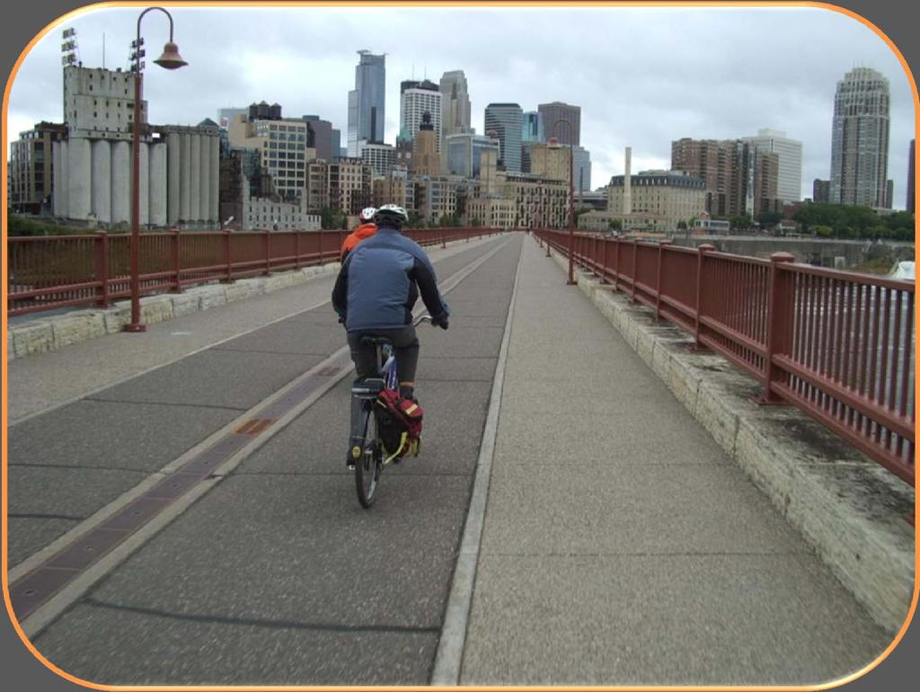
19 SHARED USE PATH PURPOSES Off-street residential connection or school access Commuting route Recreational route
 Independent rights-of-way: Advance Notice of Proposed Rulemaking (ANPRM) on Accessibility Guidelines for Shared Use")
20 ACCESSIBILITY REQUIREMENTS Must meet accessibility requirements of the Americans with Disabilities Act Public right-of-way: Public Rights-of-Way Accessibility Guidelines (PROWAG) Independent rights-of-way: Advance Notice of Proposed Rulemaking (ANPRM) on Accessibility Guidelines for Shared Use Paths

21 SHARED USE PATH BASICS Primary design user: adult bicyclist Guide instructs for adjustments if another user type is primary Paths frequently used by children: Children s design speed are accommodated in the guide Use engineering judgment to modify other values

22 SEPARATION OF DIRECTIONS Provides space for directional travel Solid where passing is not permitted Broken where passing is permitted Along entire length of trail or only where operational challenges exist

23 SEPARATION OF USERS Bi-directional walking lane for pedestrians with directional lanes of travel for cyclists At least 5 feet for pedestrians At least 10 feet for bicyclists

24 SEPARATION OF USERS In areas with extremely heavy pathway volumes

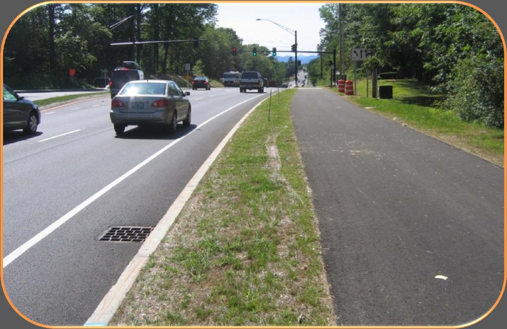
25 SEPARATION OF USERS Be aware that if pedestrians outnumber bicyclists, they are less likely to follow the rules.
26 SEPARATION OF USERS

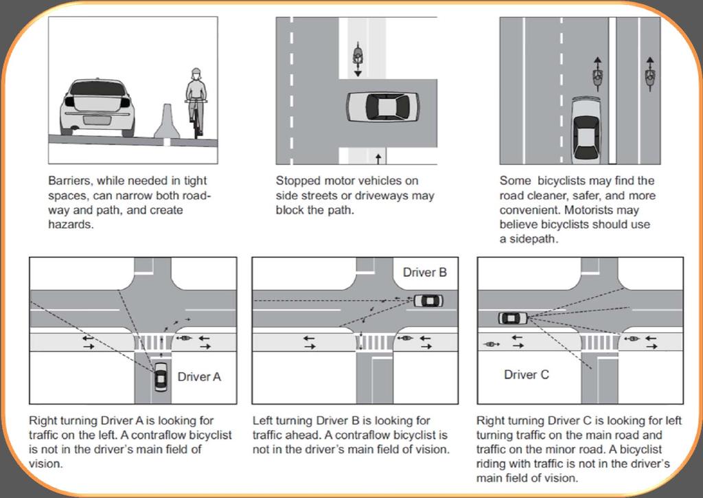
27 SIDEPATHS New term in guide Sidepath = shared-use path that runs along a roadway Supplements, does not substitute on-road bicycle facilities Provides separation from motor vehicles, Guide has extended guidance on potential conflicts
28 ONE-WAY SIDEPATHS May be possible to place one-way paths on both sides of a roadway Provides planning and design considerations GET the best picture of Cambridge s MIT cycletrack from Nick
29 SIDEPATHS
30 SIDEPATHS
31 SIDEPATHS

32 SIDEPATHS If along a high-speed highway, a sidepath should have 5 feet or more separation or a barrier

33 SHARED USE PATH DESIGN BASICS Widths and Clearance Design Speed Horizontal Alignment Cross Slope Vertical Alignment Stopping Sight Distance Other Considerations (Surface, Bridges & Underpasses, Drainage, Lighting)

34 WIDTH AND CLEARANCE 10 feet = minimum width 11 feet is needed for passing 10- to 14-foot width is typical Wider path accommodates higher volumes or more varied user groups Guide sets forth specific scenarios where a wider path may be warranted 8 feet is acceptable in rare circumstances

35 SHOULDERS Graded should 3-5 feet recommended with maximum 1:6 cross slope Minimum 2-foot clearance or 1-foot clearance to smooth features Recommended 5-foot separation to roadways, use barrier or rail if less than 5 feet
36 SHOULDERS Provide 5-foot separation to trailside hazards or slopes of 1:3 or steeper Provide barrier or safety rail if separation is less than 5 feet
37 SHOULDERS Provide 5-foot separation to trailside hazards or slopes of 1:3 or steeper Provide barrier or safety rail if separation is less than 5 feet
38 SHOULDERS Provide 5-foot separation to trailside hazards or slopes of 1:3 or steeper Provide barrier or safety rail if separation is less than 5 feet

39 DESIGN SPEED Old guide: minimum 20 mph design speed New guide: 18 mph generally sufficient Additional guidance on selecting design speed Higher in hilly terrain, up to 30 mph


40 HORIZONTAL ALIGNMENT: LEAN ANGLE Maximum lean angle = 20 degrees Min. Curve 60 feet at 18 mph


41 HORIZONTAL ALIGNMENT: SUPERELEVATION Recommended for unpaved paths or bike only paths with tighter curves
42 CROSS SLOPE PROWAG & ANPRM on Shared Use Paths require maximum cross slopes of 2% 1% recommended Superelevation typically not needed, so cross slopes can follow terrain Transition Rate 1% in 5 feet
43 SPEED CONTROL ON PATHS Introduces concept of using geometry (curvature) and traffic control to reduce user speed Depends on site specifics

44 GRADE Between 0.5 & 5%, no steeper than adjacent roadway New guide removes specific grade restrictions, refers to shared-use path provisions in ANPRM for paths. To mitigate excessive grades, consider: Higher design speeds 4 to 6 ft additional width Exceed min clearances, recovery areas, railings Hill warning sign for bikes, other signage Switchbacks with extra width Resting intervals w/ flatter grades


45 STOPPING SIGHT DISTANCE Based on wet conditions New 0.16 braking coefficient of friction 2.5 seconds reaction time
46 VERTICAL CURVE LENGTH Consider other users Recumbent cyclists sit lower and travel faster, if many are expected, crests should be longer

47 HORIZONTAL SIGHT DISTANCE

48 UNPAVED PATHS May be appropriate for rural or recreational paths Typically crushed stone, stabilized earth, limestone screenings However Some users cannot traverse Drainage issues Difficult to plow

49 PATH SURFACE Asphalt Typically lower construction cost Concrete Typically longer service life Maintain a smooth surface Consider subsurface drainage
 Bridge railings 42 inches (48 inches in some cases) Vertical clearance 10")
50 BRIDGES AND UNDERPASSES Maintain at least minimum path and shoulder widths, typically 14 feet (10-foot path & two 2-foot shoulders) Bridge railings 42 inches (48 inches in some cases) Vertical clearance 10 feet
51 DRAINAGE Minimum recommended slope of 1% Cross slope with terrain if possible If needed, ditches and culverts should not present a hazard Consider low-impact development techniques

52 LIGHTING Where nighttime use is permitted Pedestrian scale fixtures Consider 0.5 to 2 foot candles Higher illumination at crossings

53 THANK YOU! Contact information: Questions? Eric Mongelli, P.E. Toole Design Group Tom Huber Toole Design Group
54 FUTURE WEBINARS August 10: Overview August 22: Planning Chapter September 4: On-Road Bikeways Part I Bike Lanes (including Intersections) September 18: On-Road Bikeways Part II Shared lanes Bicycle boulevards & signing Signals October 9: Shared Use Paths General design principles Pathway geometry October 23: Shared Use Paths Intersection Design Mid-block crossings November 6: Bikeway Maintenance and Operation
55 WEBINAR 6: ROAD/PATHWAY INTERSECTIONS Midblock & side path crossings Intersection control treatments Assignment of right-of-way Other crossing considerations Transition zone Traffic calming at intersections Approach markings and signs Webinar Date: October 23 Presenters: Eric Mongelli, PE & William Schultheiss, PE
On Road Bikeways Part 1: Bicycle Lane Design
 On Road Bikeways Part 1: Bicycle Lane Design Presentation by: Nick Jackson Bill Schultheiss, P.E. September 04, 2012 FOLLOW THE CONVERSATION ON TWITTER Toole Design Group is live tweeting this webinar
The 2012 AASHTO Bike Guide: An Overview
 The 2012 AASHTO Bike Guide: An Overview Presentation by: Jennifer Toole, AICP, ASLA Peter Lagerwey August 10, 2012 {Enter Module Name on Master Slide} WEBINAR #1: OVERVIEW OF 2012 AASHTO BIKE GUIDE Today
Off-road Trails. Guidance
 Off-road Trails Off-road trails are shared use paths located on an independent alignment that provide two-way travel for people walking, bicycling, and other non-motorized users. Trails specifically along
General Design Factors
 Chapter 3: 3-1.0 Introduction General Design Factors Mn/DOT s goals include encouraging and accommodating safe bicycling. From a design perspective, these goals are achieved by first having an understanding
Shared Use Path Design
 12B-2 Design Manual Chapter 12 - Sidewalks and Bicycle Facilities 12B - Bicycle Facilities Shared Use Path Design A. Accessible Shared Use Path Design 1. General: Applicable portions from the following
Toole Design Group is live tweeting this webinar
 On Road Bikeways Part I1: Non-Bike Lane Design Presentation by: Bill Schultheiss, P.E. Tina Fink, P.E. September18, 2012 FOLLOW THE CONVERSATION ON TWITTER Toole Design Group is live tweeting this webinar
Chapter 5 Shared-Use Paths
 Chapter 5: 5-1.0 Introduction Shared-Use Paths This chapter provides guidelines for design of bicycle transportation facilities that are separated from the roadway. In most cases, a path separated from
700 Multi-Modal Considerations
 700 Multi-Modal Considerations Table of Contents 701 Railroads... 7-1 701.1 Background... 7-1 701.2 Crossing At-Grade... 7-1 701.2.1 General... 7-1 701.2.2 Railroad Parallel to Highway... 7-1 701.3 Lateral
Memorandum. Exhibit 60 SSDP To: Jenny Bailey, Senior Planner. From: Bill Schultheiss, P.E. (WA. P.E. #46108) Date: June 20, 2017
 Date: June 20, 2017") Memorandum To: Jenny Bailey, Senior Planner From: Bill Schultheiss, P.E. (WA. P.E. #46108) Date: June 20, 2017 Re: East Lake Sammamish Trail, Segment 2B Review King County has asked Toole Design Group
Memorandum To: Jenny Bailey, Senior Planner From: Bill Schultheiss, P.E. (WA. P.E. #46108) Date: June 20, 2017 Re: East Lake Sammamish Trail, Segment 2B Review King County has asked Toole Design Group
City of Roseville Section 13 Design Standards. _Bikeways January 2016 SECTION 13 BIKEWAYS
 SECTION 13 BIKEWAYS 13-1 GENERAL The City of Roseville bikeway standards are designed to insure that transportation and recreational bikeways are constructed in a manner that would provide a safe and comfortable
Appendix T CCMP TRAIL TRAFFIC & TRANSPORTATION DESIGN STANDARD
 Appendix T CCMP 3.3.4 TRAIL TRAFFIC & TRANSPORTATION DESIGN STANDARD 3.3.4 Trail Traffic and Transportation Design Multi-use trails have certain design standards, which vary depending on the agency that
Planning Guidance in the 2012 AASHTO Bike Guide
 Planning Guidance in the 2012 AASHTO Bike Guide Presentation by: RJ Eldridge Peter Lagerwey August 22, 2012 WEBINAR 2: PLANNING GUIDANCE IN THE 2012 AASHTO BIKE GUIDE Today s Webinar Significant Updates
Small Town & Rural Multimodal Networks
 Small Town & Rural Multimodal Networks Fred Young, PLA Andrea Clinkscales, AICP, PMP Alta Planning + Design Funding Partners Project Team Existing Design Guidance AASHTO Flexibility Guide 2004 AASHTO Bike
2012 by the American Association of State Highway and Transportation Officials. All rights reserved. Duplication is a violation of applicable law.
 Table of Contents Chapter 1: Introduction... 1-1 1.1 Design Imperative... 1-1 1.2 Purpose... 1-1 1.3 Scope... 1-2 1.4 Definitions... 1-2 Chapter 2: Bicycle Planning... 2-1 2.1 Background... 2-1 2.2 Why
2018 AASHTO BIKE GUIDE
 2018 AASHTO BIKE GUIDE Your presenters Jessica Fields, PE Denver Office Director Sagar Onta, PE, PTOE Denver Engineering Director 35 years of combined experience street design, transportation planning,
Appendix 3 Roadway and Bike/Ped Design Standards
 Appendix 3 Roadway and Bike/Ped Design Standards OTO Transportation Plan 2040 4/20/2017 Page A3-1 Adopted Standards The adopted OTO Design Standards and Major Thoroughfare Plan are contained herein.
INDEX. Geometric Design Guide for Canadian Roads INDEX
 Acceleration lane, see Lanes, Acceleration Access, 8.1 Access Management and Functional Classification 8.2 Access Management by Design Classification 8.3 Access Configuration 8.4 Building Set-Back Guidelines
Construction Specifications Manual
 Isle of Wight County Pedestrian and Bicycle Master Plan Construction Specifications Manual Adopted August 20, 2009 Introduction The Isle of Wight County Pedestrian and Bicycle Facilities Master Plan was
Who is Toole Design Group?
 2018 AASHTO Bike Guide Status Update NCHRP 15 60 Amalia Leighton Cody, PE, AICP & Kenneth Loen, PE Washington APWA October 4, 2018 Who is Toole Design Group? TDG is a full service engineering, planning
Chapter 3 DESIGN SPECIFICATIONS
 Brampton PathWays Planning and Design Guidelines 27 Chapter 3 DESIGN SPECIFICATIONS 3.1 CLASS 1 MULTI-USE PATH Off-road multi-use trails are the backbone of the Brampton PathWays Network. They are typically
Geometric Design Tables
 Design Manual Chapter 5 - Roadway Design 5C - Geometric Design Criteria 5C-1 Geometric Design Tables A. General The following sections present two sets of design criteria tables - Preferred Roadway Elements
3-13 UFC - GENERAL PROVISIONS AND GEOMETRIC DESIGN FOR ROADS, STREETS, WALKS, AND OPEN
 maintenance, and erosion. Stability is required to maintain the integrity of the pavement structure, and a slope stability analysis should be conducted for cuts and fills greater than 15 feet. For lower
2018 AASHTO BIKE GUIDE
 2018 AASHTO BIKE GUIDE Your presenter Rob Burchfield, PE NW Regional Engineering Director 35 years of experience in traffic engineering and bicycle facility design Toole Design Group Toole Design Group
Alberta Infrastructure HIGHWAY GEOMETRIC DESIGN GUIDE AUGUST 1999
 Alberta Infrastructure HIGHWAY GEOMETRIC DESIGN GUIDE AUGUST 1999,1'(; A ACCELERATION Data on acceleration from stop D-29 Effects of grade D-35 Intersections D-97, D-99 Lanes D-97, F-5, F-7, F-15, F-21,
Driveway Design Criteria
 Design Manual Chapter 5 - Roadway Design 5L - Access Management 5L-4 Driveway Design Criteria A. General For efficient and safe operations, access drives and minor public street intersections can be improved
4. TRAIL DESIGN GUIDELINES
 Trail Design Guidelines 4. TRAIL DESIGN GUIDELINES This chapter provides specific design guidelines for the Humboldt Bay Trail that are consistent with the guidelines currently observed in California and
Route 47 (North Main Street) Reconstruction
 Reconstruction") TOWN OF SUNDERLAND Route 47 (North Main Street) Reconstruction Presented by Lou Rabito, P.E. Presented to Town of Sunderland June 11, 2018 Project Overview MassDOT Project No. 607245 Resurfacing and Related
TOWN OF SUNDERLAND Route 47 (North Main Street) Reconstruction Presented by Lou Rabito, P.E. Presented to Town of Sunderland June 11, 2018 Project Overview MassDOT Project No. 607245 Resurfacing and Related
October 2004 REVISIONS (2) SUPERELEVATION DEVELOPMENT 11.3(2)
 SUPERELEVATION DEVELOPMENT 11.3(2)") October 2004 REVISIONS (2) Chapter 11 HORIZONTAL ALIGNMENT SUPERELEVATION DEVELOPMENT 11.3(2) Chapter 12 VERTICAL ALIGNMENT VERTICAL CURVES PASSING SIGHT DISTANCE 12.5(2) VERTICAL CURVES STOPPING SIGHT
October 2004 REVISIONS (2) Chapter 11 HORIZONTAL ALIGNMENT SUPERELEVATION DEVELOPMENT 11.3(2) Chapter 12 VERTICAL ALIGNMENT VERTICAL CURVES PASSING SIGHT DISTANCE 12.5(2) VERTICAL CURVES STOPPING SIGHT
FHWA Bikeway Selection Guide
 FHWA Bikeway Selection Guide Tamara Redmon Federal Highway Administration Bill Schultheiss Toole Design Lauren Blackburn VHB March 26, 2019 PBIC Webinar pedbikeinfo.org @pedbikeinfo Housekeeping Problems
CHAPTER 1 STANDARD PRACTICES
 CHAPTER 1 STANDARD PRACTICES OBJECTIVES 1) Functions and Limitations 2) Standardization of Application 3) Materials 4) Colors 5) Widths and Patterns of Longitudinal Pavement Marking Lines 6) General Principles
Chapter 4 On-Road Bikeways
 Chapter 4: 4-1.0 Introduction On-Road Bikeways This chapter provides guidelines to help select and design safe on-road bikeways. On-road bikeways include bicycle lanes, shared lanes, shoulders, and wide
American Railway Engineering and Maintenance of Way Association Letter Ballot. Draft
 American Railway Engineering and Maintenance of Way Association Letter Ballot 1. Committee and Subcommittee: Committee 5 Track Subcommittee 9 Road Crossings 2. Letter Ballot Number: 05-17-16 3. Assignment:
Connecting cyclists to work. Syracuse Metropolitan Transportation Council
 Connecting cyclists to work Syracuse Metropolitan Transportation Council Overview Prepared at request: NYS Department of Transportation (NYSDOT) Project Achievements Target group Purpose Process Recommendations
City of Oxnard Bicycle & Pedestrian Facilities Master Plan Appendices
 City of Oxnard Bicycle & Pedestrian Facilities Master Plan Appendices Approved by the City of Oxnard City Council February 2011 Prepared for: City of Oxnard Prepared by: Alta Planning + Design City of
WYDOT DESIGN GUIDES. Guide for. Non-NHS State Highways
 WYDOT DESIGN GUIDES Guide for Non-NHS State Highways 2014 GUIDE FOR Non-NATIONAL HIGHWAY SYSTEM (Non-NHS) STATE HIGHWAYS PRESERVATION REHABILITATION RECONSTRUCTION INTRODUCTION This Guide is directed to
APPENDIX B(1) SUBDIVISION STREET DESIGN GUIDE. SECTION B(1) 1 INTRODUCTION Introduction... B(1)-1
 SUBDIVISION STREET DESIGN GUIDE. SECTION B(1) 1 INTRODUCTION Introduction... B(1)-1") APPENDIX B(1) SUBDIVISION STREET DESIGN GUIDE SECTION B(1) 1 INTRODUCTION Introduction... B(1)-1 SECTION B(1) 2 DESIGN REQUIREMENTS Projected Traffic / Operational / Capacity Analysis... B(1)-2 Functional
APPENDIX B(1) SUBDIVISION STREET DESIGN GUIDE SECTION B(1) 1 INTRODUCTION Introduction... B(1)-1 SECTION B(1) 2 DESIGN REQUIREMENTS Projected Traffic / Operational / Capacity Analysis... B(1)-2 Functional
Gordon Proctor Director Policy on Accommodating Bicycle and Pedestrian Travel on ODOT Owned or Maintained Facilities
 Approved: Policy: 20-004(P) Responsible Office: Planning Gordon Proctor Director Policy on Accommodating Bicycle and Pedestrian Travel on ODOT Owned or Maintained Facilities I. POLICY STATEMENT: This policy
MAG Town of Cave Creek Bike Study Task 6 Executive Summary and Regional Significance Report
 Page 1 MAG Town of Cave Creek Bike Study Task 6 Executive Summary and Regional Significance Report August 1, 2012 MAG Project #481 Page 2 Task 6 Executive Summary and Regional Significance Report Introduction
RURAL HIGHWAY SHOULDERS THAT ACCOMMODATE BICYCLE AND PEDESTRIAN USE (TxDOT Project ) June 7, Presented by: Karen Dixon, Ph.D., P.E.
 June 7, Presented by: Karen Dixon, Ph.D., P.E.") RURAL HIGHWAY SHOULDERS THAT ACCOMMODATE BICYCLE AND PEDESTRIAN USE (TxDOT Project 0-6840) June 7, 2016 Presented by: Karen Dixon, Ph.D., P.E., TTI Team: Kay Fitzpatrick, Raul Avelar, & Subasish Das Project
RURAL HIGHWAY SHOULDERS THAT ACCOMMODATE BICYCLE AND PEDESTRIAN USE (TxDOT Project 0-6840) June 7, 2016 Presented by: Karen Dixon, Ph.D., P.E., TTI Team: Kay Fitzpatrick, Raul Avelar, & Subasish Das Project
What Is a Complete Street?
 Session 5 Charleen Zimmer, AICP, Zan Associates May 5-7, 2010 What Is a Complete Street? May 2010 5-1 Not a Complete Street More of a Complete Street May 2010 5-2 Benefits of Complete Streets Safety for
Designing with the Railroad
 Designing with the Railroad 23 CFR 646.214 (b)(2) requires that crossings be evaluated when they are within limits or near terminus of Federally Funded project. Some rough numbers for planning: Active
DISTRIBUTION: Electronic Recipients List TRANSMITTAL LETTER NO. (17-01) MINNESOTA DEPARTMENT OF TRANSPORTATION. MANUAL: Road Design English Manual
 MINNESOTA DEPARTMENT OF TRANSPORTATION. MANUAL: Road Design English Manual") DISTRIBUTION: Electronic Recipients List MINNESOTA DEPARTMENT OF TRANSPORTATION DEVELOPED BY: Design Standards Unit ISSUED BY: Office of Project Management and Technical Support TRANSMITTAL LETTER NO.
DISTRIBUTION: Electronic Recipients List MINNESOTA DEPARTMENT OF TRANSPORTATION DEVELOPED BY: Design Standards Unit ISSUED BY: Office of Project Management and Technical Support TRANSMITTAL LETTER NO.
APPENDIX A: Complete Streets Checklist DRAFT NOVEMBER 2016
 APPENDIX A: Complete Streets Checklist DRAFT NOVEMBER 2016 Complete Streets Checklist MetroPlan Orlando s Complete Streets Checklist is an internal planning tool for staff to further implementation of
Appendix A: Facility Design Guidelines
 Appendix A: Facility Design Guidelines CONNECTING OUR COMMUNITY TABLE OF CONTENTS Chapter One: Introduction and Background, p. A-1 National Guidelines, p. A-2 Local Guidelines, p. A-3 Chapter Two: User
ATTACHMENT NO. 11. RRLRT No. 2. Railroad / Light Rail Transit Technical Committee TECHNICAL COMMITTEE: Busway Grade Crossings STATUS/DATE OF ACTION
 ATTACHMENT NO. 11 RRLRT No. 2 TECHNICAL COMMITTEE: TOPIC: Railroad / Light Rail Transit Technical Committee Busway Grade Crossings STATUS/DATE OF ACTION RRLRT TC Draft: 06/23/2011 RRLRT TC Approval: 06/27/2014
NJDOT Complete Streets Checklist
 Background The New Jersey Department of Transportation s Complete Streets Policy promotes a comprehensive, integrated, connected multi-modal network by providing connections to bicycling and walking trip
Complete Streets Policy DAVID CRONIN, P.E., CITY ENGINEER
 Complete Streets Policy DAVID CRONIN, P.E., CITY ENGINEER Complete Streets City Commission adopted a Complete Streets policy in 2012 Complete Streets are road networks that are designed for all users:
WYDOT DESIGN GUIDES. Guide for. NHS Arterial (Non-Interstate)
") WYDOT DESIGN GUIDES Guide for NHS Arterial (Non-Interstate) 2014 GUIDE FOR NATIONAL HIGHWAY SYSTEM (NHS) HIGHWAYS (NHS ARTERIALS, Non-Interstate) PRESERVATION REHABILITATION RECONSTRUCTION INTRODUCTION
WYDOT DESIGN GUIDES Guide for NHS Arterial (Non-Interstate) 2014 GUIDE FOR NATIONAL HIGHWAY SYSTEM (NHS) HIGHWAYS (NHS ARTERIALS, Non-Interstate) PRESERVATION REHABILITATION RECONSTRUCTION INTRODUCTION
PBIC Webinar. How to Create a Bicycle Safety Action Plan: Planning for Safety [IMAGE] Oct. 2, 2014, 2 pm
![PBIC Webinar. How to Create a Bicycle Safety Action Plan: Planning for Safety [IMAGE] Oct. 2, 2014, 2 pm](/thumbs/86/93953441.jpg "PBIC Webinar. How to Create a Bicycle Safety Action Plan: Planning for Safety [IMAGE] Oct. 2, 2014, 2 pm") PBIC Webinar How to Create a Bicycle Safety Action Plan: Planning for Safety [IMAGE] Bill Schultheiss, Vice President, Toole Design Peter Lagerwey, Regional Director, Toole Design Oct. 2, 2014, 2 pm Today
PBIC Webinar How to Create a Bicycle Safety Action Plan: Planning for Safety [IMAGE] Bill Schultheiss, Vice President, Toole Design Peter Lagerwey, Regional Director, Toole Design Oct. 2, 2014, 2 pm Today
Multimodal Through Corridors and Placemaking Corridors
 68 Multimodal Through Corridors and Placemaking Corridors Corridors have different functions in a region. Some corridors are used to get smoothly and rapidly through a region or to get quickly to major
REGIONAL BICYCLE AND PEDESTRIAN DESIGN GUIDELINES
 REGIONAL BICYCLE AND PEDESTRIAN DESIGN GUIDELINES November 16, 2011 Deb Humphreys North Central Texas Council of Governments Bicycle and Pedestrian Advisory Committee Snapshot of the Guide 1. Introduction
Accommodating Pedestrians in the Work Zone
 Accommodating Pedestrians in the Work Zone Guidance for Section C Plan Preparers Some impacts cannot be avoided and those impacts apply to residents, businesses, motorists, and pedestrians alike. However,
South Carolina Department of Transportation. Engineering Directive
 South Carolina Department of Transportation Engineering Directive Directive Number: ED-22 Effective: December 16, 2009 Subject: References: Purpose: This Directive Applies to: Considerations for Bicycle
This page intentionally left blank.
 Appendix F. Design Guidelines County of Los Angeles Bicycle Master Plan This page intentionally left blank. F-2 Alta Planning + Design F Design Guidelines The County of Los Angeles works to implement on-and
Multimodal Design Guidance. October 23, 2018 ITE Fall Meeting
 Multimodal Design Guidance October 23, 2018 ITE Fall Meeting Introductions Jessica Wilson TDOT Multimodal Division Office of Multimodal Planning Program Supervisor Jessica.L.Wilson@tn.gov Ali Hangul TDOT
Roadway Design Manual
 Roadway Design Manual Revised December 2013 2013 by Texas Department of Transportation (512) 302-2453 all rights reserved Manual Notice 2013-1 From: Manual: Mark A. Marek, P.E Roadway Design Manual Effective
Appendix B HDM CH 1000 BIKEWAY PLAN & DESIGN
 Appendix B HDM CH 1000 BIKEWAY PLAN & DESIGN HIGHWAY DESIGN MANUAL 1000-1 CHAPTER 1000 BIKEWAY PLANNING AND DESIGN Topic 1001 - General Criteria Index 1001.1 - Introduction The needs of non-motorized transportation
CITY OF SARATOGA SPRINGS PEDESTRIAN CROSSING TOOLBOX
 CITY OF SARATOGA SPRINGS PEDESTRIAN CROSSING TOOLBOX This toolbox is to be used to guide pedestrian crossing improvements within the City of Saratoga Springs. Details for each crossing type are provided.
Figure 1: Graphical definitions of superelevation in terms for a two lane roadway.
 Iowa Department of Transportation Office of Design Superelevation 2A-2 Design Manual Chapter 2 Alignments Originally Issued: 12-31-97 Revised: 12-10-10 Superelevation is the banking of the roadway along
2014 FHWA Aging Road User Handbook. Recommendations to Accommodate Aging Pedestrians. Lifesaver National Conference. What is the Handbook?
 2014 FHWA Aging Road User Handbook Recommendations to Accommodate Aging Pedestrians Lifesaver National Conference March 17, 2015 Revised June 2014 1 What is the Handbook? 1998 1st Edition 2001 2nd Edition
This Chapter sets forth the minimum design, technical criteria and specifications to be used in the preparation of all roadway plans.
 4.1 GENERAL This Chapter sets forth the minimum design, technical criteria and specifications to be used in the preparation of all roadway plans. These Roadway Standards are for new construction and modification
ADA on Construction. Guidance for Section C Plan Preparers
 ADA on Construction Guidance for Section C Plan Preparers Some impacts cannot be avoided and those impacts apply to residents, businesses, motorists, and pedestrians alike. However, good planning can minimize
Shared Use Facili es. Mul -Use Trails. Chapter 3 Design Elements BICYCLE/PEDESTRIAN MULTI USE TRAILS
 Shared Use Facili es "Shared Use" or "Mul -Use" facili es are those where bicyclists share a facility with pedestrians and other non-motorized modes of travel such as equestrians, cross country skiers,
Chapter Twenty-eight SIGHT DISTANCE BUREAU OF LOCAL ROADS AND STREETS MANUAL
 Chapter Twenty-eight SIGHT DISTANCE BUREAU OF LOCAL ROADS AND STREETS MANUAL Jan 2006 SIGHT DISTANCE 28(i) Chapter Twenty-eight SIGHT DISTANCE Table of Contents Section Page 28-1 STOPPING SIGHT DISTANCE
Section 9A.07 Meaning of Standard, Guidance, Option, and Support
 2012 Edition Page 895 PART 9. TRAFFIC CONTROLS FOR BICYCLE FACILITIES CHAPTER 9A. GENERAL Section 9A.01 Requirements for Bicyclist Traffic Control Devices 01 General information and definitions concerning
CHAPTER 16 PEDESTRIAN FACILITIES DESIGN AND TECHNICAL CRITERIA TABLE OF CONTENTS
 CHAPTER 16 PEDESTRIAN FACILITIES DESIGN AND TECHNICAL CRITERIA TABLE OF CONTENTS Section Title Page 16.1 General... 16-1 16.1.1 AASHTO Reference... 16-1 16.1.2 ADA Requirements... 16-1 16.2 Sidewalks...
THE FUTURE OF THE TxDOT ROADWAY DESIGN MANUAL
 THE FUTURE OF THE TXDOT ROADWAY DESIGN MANUAL Kenneth Mora, P.E. (Design Division) 10/10/2017 Table of contents 1 2 Reduction in FHWA design controlling criteria Innovative Intersection Guidance 3-7 8-42
Roadway Design Manual
 Roadway Design Manual Manual Notice Archive by Texas Department of Transportation (512) 302-2453 all rights reserved Manual Notice 2009-1 From: Manual: Mark A. Marek, P.E Roadway Design Manual Effective
ROUNDABOUTS/TRAFFIC CIRCLES
 GENERAL 1. Description This standard identifies minimum requirements that shall be met for Roundabouts and Neighborhood Traffic Circles in the design and construction of elements for Arlington County Horizontal
GDOT Cross Section Elements. Course ID: GDOT PDH Credits
 GDOT Cross Section Elements Course ID: GDOT-01 2 PDH Credits Civil Engineer Educators LLC 1026 Timberwolf Lane Juneau, AK 99801 Email: support@civilpdh.com Chapter 6 Contents 6. CROSS SECTION ELEMENTS
Page 1B-6 Added the following definition; AUXILIARY LANE See LANE
 IMPERIAL ROAD DESIGN MANUAL REVISIONS January, 2013 CHAPTER 1B Page 1B-6 Added the following definition; AUXILIARY LANE See LANE Page 1B-8 Added the following definition; Engineer The Engineer representing
OBJECTIVE: Improve safety by designing all bicycle facilities to the latest AASHTO bicycle guidelines and 2009 MUTCD Standards.
 DESIGN AND APPLICATION OF GUIDELINES AND STANDARDS The Citizen Advisory and Technical Advisory Committees identified improving safety by providing consistent bicycle facilities throughout the region as
How Might Connected Vehicles and Autonomous Vehicles Influence Geometric Design? October 10, 2017
 How Might Connected Vehicles and Autonomous Vehicles Influence Geometric Design? October 10, 2017 Overview Design Vehicle Design Driver Potential Geometric Impacts of Autonomous Vehicles Connected Vehicles
Chapter 3 - Local Urban Road System CHAPTER 3 LOCAL URBAN ROAD SYSTEM
 CHAPTER 3 LOCAL URBAN ROAD SYSTEM 3.0 INTRODUCTION As in Chapter 2 for the local rural road system, the local urban road system also utilizes the concepts of land use context, functional classification
Clear Zone Conflicts in AASHTO Publications
 Clear Zone Conflicts in AASHTO Publications Dick Albin Washington State Department of Transportation Presented at the AASHTO Sub Committee on Design Meeting June 2007 Burlington, Vermont Clear Zone is
INDOT Complete Streets Guideline & Policy
 INDOT Complete Streets Guideline & Policy INTRODUCTION The Complete Streets guidelines build upon multiple efforts and promote a multimodal transportation system that is integrated and sustains land use
FEDERAL HIGHWAY ADMINISTRATION APPLICATION
 FEDERAL HIGHWAY ADMINISTRATION APPLICATION REQUEST FOR PERMISSION TO EXPERIMENT WITH A BICYCLE BOX INTERSECTION TREATMENT Submitted by: City of Columbus Department of Public Service Date: June 26, 2009
GEOMETRIC DESIGN STANDARDS FOR NEW RESIDENTIAL SUBDIVISION STREETS TABLE 1A CG-6 CURB AND GUTTER SECTION
 TABLE 1A CG-6 CURB AND GUTTER SECTION HORIZONTAL AND VERTICAL CONTROLS CURB AND GUTTER ROADWAYS MAXIMUM 3:1 CUT OR FILL SLOPE CURVE DATA MIN. SIGHT DISTANCE PROJECTED TRAFFIC VOLUME (ADT) MIN. DESIGN SPEED
Zlatko Krstulich, P.Eng. City of O9awa
 Zlatko Krstulich, P.Eng. City of O9awa 1. Introduction to the Ontario Traffic Manual Series 2. What is OTM Book 18: Bicycle Facilities? 3. Study / Committee Team Members 4. Brief overview of the content
ACTIVE TRANSPORTATION
 ACTIVE TRANSPORTATION Mobility 2040 Supported Goals Improve the availability of transportation options for people and goods. Support travel efficiency measures and system enhancements targeted at congestion
Bicycle Plan. Technical Design Handbook
 2010 Bicycle Plan Technical Design Handbook 0 Technical Design Handbook, 2010 Bicycle Plan Introduction This Technical Design Handbook is intended to assist the City in the selection and design of bicycle
Overview. Illinois Bike Summit IDOT Complete Streets Policy Presentation. What is a Complete Street? And why build them? And why build them?
 Overview Illinois Bike Summit IDOT Complete Streets Policy Presentation Aren Kriks, P.E. District One Bicycle Coordinator and Bureau of Programming Project Engineer History of Complete Streets IDOT Policy
The City of Sault Ste. Marie Cycling Master Plan
 4.0 DESIGN GUIDELINES - Development This section provides direction to those who will be constructing trails in the future. The contents are technical, providing facility types and locations, construction
TRAFFIC SIGNAL WARRANT STUDY
 TRAFFIC SIGNAL WARRANT STUDY 5 th STREET & ENCHANTED PINES DRIVE JANUARY 2013 TRAFFIC OPERATIONS ENGINEERING SERVICES/PUBLIC WORKS DEPARTMENT TABLE OF CONTENTS INTERSECTION LOCATION MAP ii INTRODUCTION
PROCEDURE FOR ACCOMMODATING PEDESTRIANS IN WORK ZONES FOR CONSTRUCTION AND MAINTENANCE
 PROCEDURE FOR ACCOMMODATING PEDESTRIANS IN WORK ZONES FOR CONSTRUCTION AND MAINTENANCE A.1 STANDARD Measures shall be taken to accommodate pedestrian traffic through and/or around Work Zones for Construction
Field Design, Construction and inspection of ADA compliant Curb ramps. Mike Anderson City of Lee s Summit Construction Manager (816)
") Field Design, Construction and inspection of ADA compliant Curb ramps Mike Anderson City of Lee s Summit Construction Manager (816)969-1800 Today s Agenda Definitions & Acronyms Access Board vs. PROWAAC
Field Design, Construction and inspection of ADA compliant Curb ramps Mike Anderson City of Lee s Summit Construction Manager (816)969-1800 Today s Agenda Definitions & Acronyms Access Board vs. PROWAAC
PART 9. TRAFFIC CONTROLS FOR BICYCLE FACILITIES TABLE OF CONTENTS
 2006 Edition Page TC9-1 PART 9. TRAFFIC CONTROLS FOR BICYCLE FACILITIES TABLE OF CONTENTS SECTIONS CHAPTER 9A. Section 9A.01 Section 9A.02 Section 9A.03 Section 9A.04 Section 9A.05 Section 9A.06 Section
ADDENDUM NUMBER ONE (1) For
 For") ADDENDUM NUMBER ONE (1) For OCCOQUAN REGIONAL PARK MULTIPURPOSE TRAIL Recreation Trails Program (RTP) Federal Highway Administration (FHWA) CFDA Number: 20.219 State Project Number: VRT-301 In Lorton,
ADDENDUM NUMBER ONE (1) For OCCOQUAN REGIONAL PARK MULTIPURPOSE TRAIL Recreation Trails Program (RTP) Federal Highway Administration (FHWA) CFDA Number: 20.219 State Project Number: VRT-301 In Lorton,
(This page left intentionally blank)
") (This page left intentionally blank) 2011 Edition- Revision 2 Page 813 CHAPTER 9A. GENERAL Section 9A.01 Requirements for Bicyclist Traffic Control Devices 01 General information and definitions concerning
(This page left intentionally blank) 2011 Edition- Revision 2 Page 813 CHAPTER 9A. GENERAL Section 9A.01 Requirements for Bicyclist Traffic Control Devices 01 General information and definitions concerning
Bicycle Paths Chapter 4
 Bicycle Paths Bicycle Paths Bicycle paths consist of multiple use paths or trails, separated from motorized vehicular traffic, on which bicycle travel is anticipated and permitted. Bicycle paths may be
Paul Huston, P.E., Design-Build Coordinator Chuck Gonderinger, HDR Engineering. Minnesota Department of Transportation (the Department)
") To: From: Paul Huston, P.E., Design-Build Coordinator Chuck Gonderinger, HDR Engineering Date: March 20, 2001 Subject: Roadway Geometric Design Criteria Project: TH 14/218 Design-Build Project, SP 7408-29,
To: From: Paul Huston, P.E., Design-Build Coordinator Chuck Gonderinger, HDR Engineering Date: March 20, 2001 Subject: Roadway Geometric Design Criteria Project: TH 14/218 Design-Build Project, SP 7408-29,
MUTCD Part 6D: Pedestrian and Worker Safety
 MUTCD Part 6D: Pedestrian and Worker Safety Section 6D.01 Pedestrian and Worker Safety The needs and control of all road users (motorists, bicyclists, and pedestrians) within the highway, including persons
MASTER BICYCLE AND PEDESTRIAN PLAN
 WELCOME! PLEASE FEEL FREE TO REVIEW THE EXHIBITS THE PRESENTATION WILL BEGIN AT 6:00 PM VILLAGE OF NORTHBROOK MASTER BICYCLE AND PEDESTRIAN PLAN DRAFT EXISTING CONDITIONS REPORT AND PUBLIC MEETING WELCOME!
Task 4 Wayfinding Elements, Placement and Technical Guidance 4.1 Wayfinding Elements
 1836 Blake Street Denver, CO 80202 720.524.7831 ww.altaplanning.com MEMO 3 Task 4 Wayfinding Elements, Placement and Technical Guidance 4.1 Wayfinding Elements Based on field reconnaissance, best practices
Guidance for Installation of Pedestrian Crosswalks on Michigan State Trunkline Highways
 Guidance for Installation of Pedestrian Crosswalks on Michigan State Trunkline Highways Michigan Department of Transportation July 7, 2014 Engineering Manual Preamble This manual provides guidance to administrative,
On-Street Bicycle Facilities
 On-Street Bicycle Facilities A. General 12B-3 Design Manual Chapter 12 - Sidewalks and Bicycle Facilities 12B - Bicycle Facilities Cyclists have similar access and mobility needs as other transportation
Access Management Standards
 Access Management Standards Section 1: Application of Access Standards This chapter describes the Department's access management standards for access connections on the county roadway system. The standards
TOWN OF PORTLAND, CONNECTICUT COMPLETE STREETS POLICY
 TOWN OF PORTLAND, CONNECTICUT COMPLETE STREETS POLICY I. VISION, GOALS & PRINCIPLES VISION To improve the streets of Portland making them safer and more accessible for all users including pedestrians,
CHAPTER 2G. PREFERENTIAL AND MANAGED LANE SIGNS
 2011 Edition - Revision 2 Page 275 Section 2G.01 Scope CHAPTER 2G. PREFERENTIAL AND MANAGED LANE SIGNS 01 Preferential lanes are lanes designated for special traffic uses such as high-occupancy vehicles
Review of Guidelines for Cycleway Safety Fencing
 Review of Guidelines for Cycleway 1.0 PURPOSE 1.1 This document is meant to provide a review of available reference documents for determining appropriate fencing requirements for cycleway paths and shared