DEVELOPMENT OF ROAD INFRASTRUCTURE SAFETY FACILITY STANDARDS FOR THE ASIAN HIGHWAY NETWORK
|
|
|
- Stuart Floyd
- 6 years ago
- Views:
Transcription


1 DEVELOPMENT OF ROAD INFRASTRUCTURE SAFETY FACILITY STANDARDS FOR THE ASIAN HIGHWAY NETWORK Bangkok APRIL 2017
2 The views expressed in this publication are those of the authors and do not necessarily reflect the views of the United Nations Secretariat. The opinions, figures and estimates set forth in this publication are the responsibility of the authors, and should not necessarily be considered as reflecting the views or carrying the endorsement of the United Nations. The designations employed and the presentation of the material in this publication do not imply the expression of any opinion whatsoever on the part of the Secretariat of the United Nations concerning the legal status of any country, territory, city or area, or of its authorities, or concerning the delimitation of its frontiers or boundaries. Mention of firm names and commercial products does not imply the endorsement of the United Nations. This publication is issued without formal editing. 2
3 Table of Contents Executive Summary Introduction Status of Road Safety in the Asian Highway member countries Current design standards for the Asian Highway Network Asian Highway Classification and Design Standards Asian Highway Database Study Approach and Structure Participating Countries Star Ratings for Road Safety Star Rating System Key Road Attributes Studied by irap Analysis Star Ratings of Road Infrastructure Safety Facilities Safer Roads Investment Plans: an Example from Indonesia Design Standards on Road Infrastructure Citations by road user Citations by road attribute Discussion on quantitative analysis The Safe System Approach Additional Design Standards Reviewed from International Sources Selected Road Infrastructure Safety Facilities for the Asian Highway Pre-selection of Road Facilities Survey in the Asian Highway Member Countries Perceived effectiveness of road infrastructure safety facilities (RIFs) Discussions and Conclusions on the Survey Star Rating Testing for the Asian Highway Design Standards irap Star Ratings Analysis approach for the Star Rating Existing Asian Highway Network Design Standards and Star Ratings Scenarios considered Results of the Star Rating Testing
4 8.6 Results by road user type Discussion and Conclusion on the Star Rating Testing Considerations and Scope of the Design Standards Considerations for the development of the design standards Scope of the Design Standards Structure of the Design Standards Evaluation of the Selected Road Infrastructure Safety facilities Other Road Infrastructure Safety Facilities Conclusions and Recommendation Appendix A: Road Design Standards and Guides Cited (Literature Review) Appendix B: Inputs from the National Experts of the Participating Countries Appendix C: Standards/Guidelines/Manuals Cited in the Survey Replies
5 Executive Summary Road safety is a sustainable development issue that needs greater attention as road traffic fatalities and injuries place a significant burden on national economies. The Asia-Pacific region accounted for 58% of the global road traffic deaths in Between 2010 and 2013, while 16 Asian Highway member countries were successful in reducing road fatalities, others failed to do so. The seventh Goal of the updated Regional Road Safety Goals and Targets for Asia and the Pacific, emphasizes on developing the Asian Highway network as a model of road safety. Studies show a strong correlation between infrastructure design and road safety and road engineering and design can influence the severity of the crashes. In this regard, the Annex II to the Intergovernmental Agreement on the Asian Highway Network which entered in to force on 4 July 2005 includes design standards for the Asian Highway Network. However, the design standard does not provide adequate guidance on the road infrastructure safety facilities. As one of the initiatives to address the road safety problem on the Asian Highway Network, the ESCAP secretariat, in association with the Korea Expressway Corporation conducted a study on the development of technical standards on road infrastructure safety facilities for the Asian Highway Network. A detailed literature review on existing standards for infrastructure element design and specification to address road safety in the Asian Highway member countries and other international sources was conducted. A list of 36 road infrastructure safety facilities was prepared. Detailed information on road infrastructure safety practices was collected from five participating countries. A survey was conducted to assess the prevalence, types and design standards of road safety facilities in the Asian Highway member countries in end The international road assessment programme (irap) methodology was used to illustrate how relative risk levels would change if road infrastructure safety facilities were added to the existing Asian Highway standard.the results concluded that there is potential to promote the use of a broader range of road infrastructure safety facilities for the Asian Highway Network. The study suggested that the Intergovernmental Agreement on the Asian Highway Network provides an adequate institutional platform for providing guidance to member countries in a number of areas and could further be used for promoting a coordinated approach to the development and adoption of standards of road infrastructure safety facilities. The study emphasizes on providing guidance to the Asian Highway member countries through a dedicated new annex to the Intergovernmental Agreement on the Asian Highway Network. In this regard, proposed mandatory minimum design standards of road infrastructure safety facilities for the Asian Highway Network which could serve as 5
6 a draft Annex IV to the Intergovernmental Agreement on the Asian Highway Network; and comprehensive design guidelines of road infrastructure safety facilities which could serve as a recommended practice for the Asian Highway Network have been developed. The study recommended the Asian Highway member countries to consider adopting and practicing technical design standards of road infrastructure safety facilities towards improving road safety on the Asian Highway Network. 6
7 1. Introduction The concept of an Asian Highway network was revived in 1992 under the framework of the Asian Land Transport Infrastructure Development (ALTID) project adopted at the 48 th Commission session, following which a number of studies were implemented over the period to bring the Asian Highway network to over 140,000 kilometres. Subsequently, the network was formalized through an Intergovernmental Agreement on the Asian Highway Network which entered into force in July Road crashes are a major challenge towards sustainable development of the Asian Highway Network as road traffic injuries place a serious burden on national economies. In 2013, the average road traffic fatality rate for the Asian Highway member countries was lower than the global average and that of the ESCAP region. In the third Ministerial Conference on Transport held in Moscow from 5 to 9 December 2016, the Transport Ministers of the ESCAP member countries adopted the updated Regional Road Safety Goals and Targets for Asia and the Pacific, The overall objective is 50 per cent reduction in fatalities and serious injuries on the roads of Asia and the Pacific over the period The seventh of the eight Goals is to develop the Asian Highway network as a model of road safety. The Pillar 2 of the Global Plan for the Decade of Action for Road Safety focuses on raising the inherent safety and protective quality of road networks for the benefits of all road users. This is intended to be achieved through the implementation of various road infrastructure agreements under the UN framework, road infrastructure assessment and improved safety-conscious planning, design, construction and operation of roads 2. In this regard, six activities are included under Pillar 2. Those include promoting safe operation, maintenance and improvement of existing road infrastructure by road authorities and the developing safe new infrastructure that meets the mobility and access needs of all users and encouraging research and development in safer roads and mobility. The roadway and roadside design elements have an effect on crash risk as those have close relationship with how road users including drivers and pedestrians perceive the road environment. The roadway elements provide guidance to the road users in their decision making process. In particular, the geometry of the road influences the crash rates as well as the severity of the crash. According to the Highway Safety Manual (HSM) of the American Association for State Highway and 1 E/ESCAP/MCT(3)/11 2 Global Plan for the Decade of Action for Road Safety Available at: 7
8 Transportation Officials (AASHTO) 3, the combination of roadway factor and human factor results in thirty three per cent of all road crashes. However, these proportions may vary depending on the environment. A study on Mumbai-Pune expressway road accidents 4 showed that human factors alone (57%) had the highest influence on the occurrence of the crashes, followed by the combination of human and infrastructure factors (22.5%). Studies show a strong correlation between infrastructure design and road safety and road engineering and design can influence the severity of the crashes. The design standards chosen for the construction of new roads should ensure that they meet the highest existing safety standards available in the field. In many countries, the installation of barriers to separate opposing directions of traffic and/or different types of vehicles, the application of access control principles, better geometric design of roads to increase the sight distance in curves and the improvement of road shoulders are examples of infrastructure-related measures that have contributed to a reduction in road accidents and fatalities wherever they have been applied. International experiences show that interventions in terms of road infrastructure to improve the driving environment can pay for themselves and the related financial investment can be recovered within a reasonable period of time 5. The Asian Highway Network consists of eight core routes that substantially cross more than one subregion and a number of other routes within subregions or member countries. Among the former are Asian Highway routes AH1 and AH6 which cross the Korean Peninsula and travel all the way to Europe at the border with Bulgaria and Belarus, respectively. While these core routes offer an interesting promise for enhanced inter- as well as intra-regional connectivity, the sections that constitute them do not fall into the same class of Asian Highway classification and design standards stipulated in Annex II to the Intergovernmental Agreement on the Asian Highway Network in the countries that they traverse. Beside these technical differences, transport operation along the routes is also made difficult by the absence of a common institutional framework to regulate movements across borders. In the light of the continuing growth of intra-regional trade, there is now concern that these technical and institutional problems could in the short- to medium-term create bottlenecks along these core routes. While harmonization of road construction standards is important, attention 3 AASHTO, Highway Safety Manual. 1 st Edn. Washington, DC. 4 Available at: 5 Ishtiaque Ahmed, Road infrastructure and road safety, Transport and Communications Bulletin for Asia and the Pacific: Designing Safer Roads, No. 83 (2013). Available from 8
9 should also be given to above-the-ground installations, in particular those linked to road safety such as speed reduction devices, roadside safety features etc. Easing drivers vehicle operation and increased safety require a predictability of events along roads and during road trips. Given that increased connectivity will gradually lead to enhanced cross-border road movements, it is highly desirable that this predictability of events be uniform along the road infrastructure of the Asian Highway member countries and that standards be established to that effect. However, the Asian Highway classification and design standards as stipulated in annex II to the Intergovernmental Agreement on the Asian Highway network 6 does not provide adequate guidance on the road infrastructure safety facilities that might be considered in addressing road safety on the Asian Highway routes. For example, no information on any proper type of guard fence is provided while it is indicated in a note that the recommended width of the median can be reduced with the proper type of guard fence. The above indicates that it would be beneficial for road safety along the Asian Highway routes, if certain standards of the road infrastructure safety facilities could be maintained along the routes. In this regard, to address the road safety problem along the Asian Highway Network and as a follow on to the previous successful collaborations between ESCAP and the Korea Expressway Corporation (KEC), the ESCAP secretariat, conducted a study during on the development of technical standards on road infrastructure safety facilities for the Asian Highway Network. The study has been a part of the initiative to achieve inclusive and sustainable development through regional cooperation and integration in transport in the Asia-Pacific region and an activity towards implementation of the Regional Action Programme for Sustainable Transport Connectivity in Asia and the Pacific, phase I ( ). 6 United Nations, Treaty Series, vol. 2323, No
10 2. Status of Road Safety in the Asian Highway member countries The Asia-Pacific region accounted for 58 per cent of the global road traffic deaths in Since 2010, there had been a mixed progress in tackling road safety among ESCAP member countries 7. Road traffic fatalities reduced from 777,000 in 2010 to 733,000 in 2013 representing a reduction of 5.6 per cent. This achievement was prominent in the low income economies with a per cent reduction. Lower middle income economies and upper middle income economies were able to reduce the numbers by 5.49 and 5.11 per cents respectively. The number of road fatalities reduced in the SAARC (-8.37%), ECO (-8.05%) and ASEAN (-0.07%) sub regions during the above period. However, in the least developed countries, the trend was opposite, representing a per cent increase. Among the ESCAP subregions, the South and South-West Asia were able to achieve a reduction of road fatalities by 8.24 per cent. On the contrary, in the North and Central Asia subregion, road fatalities increased by 5.35 per cent during the above period. The average road traffic fatality rate (fatalities per 100,000 inhabitants) for the Asian Highway member countries in 2013 (16.95) was lower than the global average (17.4) and the ESCAP region average (18.99). Between 2010 and 2013, while 16 Asian Highway member countries were successful in reducing road fatalities, others (14 countries) failed to do so. Total number of fatalities in 30 of the Asian Highway member countries 8 reduced from 771,271 in 2010 to 729,418 in 2013, representing a 5.43 per cent reduction. Georgia (-24.96%), Singapore (-23.94%) Afghanistan (-23.76%), Turkey (-23.65%), Lao People s Democratic Republic (-23.30%) and Azerbaijan (-21.55%) were able to reduce their national road fatalities by more than 20 per cent. However, indicating an opposite situation, road fatalities in Myanmar (50.61%), Sri Lanka (29.33%), Tajikistan (24.04%), Bangladesh (23.29%), Philippines (22.12%) and Mongolia (21.59%) increased by more than 20 per cent between 2010 and Figure 1 shows the WHO-estimated number of road traffic fatalities and the fatality rates per 100,000 inhabitants in the Asian Highway member countries. 7 E/ESCAP/MCT(3)/9 8 Data from the Democratic People s Republic of Korea and Turkmenistan for the year 2010 were not available. 10
11 Fatality rate per ipopulation Road traffic fatalities Figure 1: Estimated road traffic fatalities and fatality rates in the Asian Highway member countries, Road traffic fatalities Fatality rate per population Source: World Health Organization, Global Status Report on Road Safety 2015 (Geneva, 2015).
12 Road deaths in countries tend to be concentrated on a relatively small percentage of roads. In India for example, national highways which include AH Network roads - represent just 3% of all roads by length yet experienced 33% of the nation s road deaths in Many sections of the AH Network have alarmingly high rates of trauma. By comparison, it is not unusual that death rates on such roads are around ten times higher than the United Kingdom s highest risk roads. Furthermore, in each of these cases, there is evidence that reported crash numbers underestimate the true number of deaths on the roads, and so the true numbers could be higher. It is likely that road safety on the AH Network will become ever more challenging. The world s road systems will continue to rapidly expand, with India, for example, aiming to invest more than $30 billion a year building 66,000 kilometres of new roads at a rate 30 kilometres per day 9. The World Bank reports that nearly one billion people in rural areas around the world still lack access to allweather roads. 10 In an increasingly urbanized world, everybody on every trip will at some stage use a road, either as a pedestrian, bicyclist or with a vehicle. But the pressures on road networks are increasing be it economic and population growth, urbanisation, technology, or changes in how people transport themselves on roads and the lives of people are at stake. More people riding bikes or driving cars, an ageing population, even expanding the road system can all bring about an increase in road crashes. In Australia, for example, while overall road fatalities are progressively decreasing, the number of cyclist fatalities and injuries has increased significantly 11. In recognition of both the enormous public health problem that road crashes cause and the potential for large-scale action, the United Nations Sustainable Development Goals set the challenge of halving the number of global deaths and injuries from road traffic crashes by Planning Commission (Government of India): Twelfth Five Year Plan ( ) Faster, More Inclusive and Sustainable Growth BITRE. Australian cycling safety: casualties, crash types and participation levels URL:

13 3. Current design standards for the Asian Highway Network 3.1 Asian Highway Classification and Design Standards Design standards for the AH Network are set out in Annex II on Asian Highway Classification and Design Standards to the Intergovernmental Agreement on the Asian Highway Network (referred to herein as the AH Standard) 13 was adopted on 18 November 2003 by an intergovernmental meeting held in Bangkok, was open for signature in April 2004 in Shanghai and entered into force on 4 July The Annex II to the Agreement provides the minimum standards and guidelines for the construction, improvement and maintenance of Asian Highway routes. In those guidelines, Asian Highway routes are grouped into four classes: primary; class I; class II; and class III, which is specified as the minimum desirable standard. The Standard is summarised in the following table. Table 1: Asian Highway Standards summary 3.2 Asian Highway Database The Asian Highway Database includes data on the road attributes specified in the AH Standard. The database also contains provision for additional data, such as numbers of major intersections, traffic volumes and fatalities, although not all countries provide this information. The database is managed by the ESCAP Secretariat and is updated at regular intervals. The Asian Highway network currently comprises about 129,902 km of roads passing through 32 member countries excluding potential Asian Highway routes in China. Table 2 provides a summary of the current AH Network by road class. Multi-lane highways i.e. primary roads and Class I roads make up more than 33% of the network. 13 United Nations, Treaty Series, vol. 2323, No , annex II. 13
14 Furthermore, high standard roads comprising the above and Class II roads account for more than 70% of the network. Table 2: Road Class Composition in the AH Network* Primary Class I Class II Class III Below Total Class III Mileage 15,649 28,055 47,592 27,311 10, ,902 (km) Mileage % 12.16% 21.80% 36.98% 21.22% 7.84% 100% * Potential AH Routes excluded According to the latest updates in 2016, two-thirds of the AH Network is made up Class I, Class II and below Class III roads. Notably: China, India, Iran, Kazakhstan and the Russian Federation account for about half of the AH network. China accounts for more than half of all Primary class roads. India, Islamic Republic of Iran and Thailand account for more than half of all Class I roads. India, Islamic Republic of Iran, Kazakhstan and Russian Federation account for more than half of all Class II AH roads (the Russian Federation alone accounts for almost one quarter of all Class II roads). Kazakhstan, Lao People s Democratic Republic, Pakistan and Turkmenistan account for more than half of all Class III AH roads (Kazakhstan accounts for almost one quarter of all Class III roads). At present, roads of Class III or lower standards account for about 30% of the network. As the AH network is ever undergoing improvements. It is expected that the percentage of these low standard roads will decrease steadily. Some roads in the AH network traversing mountains have very tight alignment and narrow cross-sections over sheer drops e.g. AH4 China-Pakistan Highway (Karakoram Highway) and AH42 China-Nepal Highway (Friendship Highway). Major transformations were underway for the former and upgrading is being planned for the latter. Nevertheless, a proportion of roads will remain to be Class III or lower standard in the foreseeable future due to economic and technical difficulties for upgrading. 14

 Climbing")
 Interchange between Two Class II Roads (AH1 and")
15 Figure 2. Diversity of AH Network Road Types and Design Class I Road (AH1) with Footpaths and Lighting approaching a Major Bridge Crossing in Bangladesh (Google Street View 2016) Climbing Lane on a Class II Road (AH12) in Thailand (Google Street View ) Interchange between Two Class II Roads (AH1 and AH75) in the Islamic Republic of Iran (Google Earth ) 15
 in Kyrgyzstan (Google Street View")
 in the Philippines (Google Street View")

16 Class II Road traversing Mountainous Terrains (AH61) in Kyrgyzstan (Google Street View ) Skewed Intersection on a Class II Road (AH26) in the Philippines (Google Street View ) Turning Lane on a Class I road (AH6) in the Russian Federation (Google Street View ) 16

 in Turkey (Google")
17 Primary Road (AH14) through Mountainous Terrains in China At-grade Intersection between Two Class II Roads (AH1 and AH84) in Turkey (Google Earth ) 17
18 4. Study Approach and Structure The objective of the study was to provide guidelines and recommendations to the Asian Highway member countries through the followings: a) Identify road infrastructure safety facilities (RIFs) for the Asian Highway Network. b) Develop minimum design standards for the selected road infrastructure safety facilities (RIFs) for the Asian Highway Network. c) Provide guidance to the Asian Highway member countries through development of a dedicated new annex (Annex IV) to the Intergovernmental Agreement on the Asian Highway Network on road infrastructure safety facilities. d) Develop detailed design guidelines for the selected road infrastructure safety facilities (RIFs) for the Asian Highway network. To meet the above objectives of the study the following steps were followed: a) Conduct literature review on existing standards for road safety infrastructure element design and specification to address road safety in the Asian Highway member countries and international sources. b) Organize a regional seminar to map out the activities. This workshop was organized in conjunction with the World Road Congress 2015 (Seoul, November 2015). c) Collect detailed information from five participating member countries about their current practices and experiences on road infrastructure safety facilities and their existing standards. d) Pre-select specific elements of the road infrastructure facilities to be considered for the development of regional standards for road safety on the Asian Highway. e) Identify data requirements and design survey questionnaires for the information (basic data and detailed data) to be collected from the Asian Highway member countries. f) Conduct a survey in the Asian Highway member countries. Analyse the survey results to find out the current practices and experiences in the member countries on the road infrastructure safety facilities. g) Conduct star rating scenario testing for the pre-selected road infrastructure safety facilities (RIFs) using the international road assessment programme (irap) methodology. 18
19 Flow chart of Activities Detailed Literature Review Collection of Data from the Participating Countries Pre-selection of Road Infrastructure Safety Facilities Joint Seminar Seoul, November 2015 Survey in the Asian Highway member countries Star Rating Scenario Testing of Road Infrastructure Safety Facilities Short-Listing of Road Infrastructure Safety Facilities Detailed Review and Analyses of Existing Design Standards Expert Group Meeting Bangkok, October 2016 Development of Design Standards for the selected Road Infrastructure Safety Facilities Development of Detailed Design Guidelines for the selected Road Infrastructure Safety Facilities Development of a draft Annex on Road Infrastructure Safety Facilities h) Identify a short-list of road infrastructure safety facilities (RIFs) for detailed studies. i) Organize an Expert Group Meeting to discuss the preliminary findings of the study in October 2016 in Bangkok. j) Develop design standards for the short-listed road infrastructure safety facilities. This would provide general description of the standards which could be adopted by the Asian Highway member countries as minimum design standards. 19
20 k) Develop detailed design guidelines for the short-listed road infrastructure safety facilities (RIFs), which would serve as a design manual and/ guidelines to the Asian Highway member countries. l) Provide guidance to the Asian Highway member countries through development of a dedicated new annex (Annex IV) to the Intergovernmental Agreement on the Asian Highway Network on road infrastructure safety facilities. Participating Countries The selected participating countries are located along Asian Highway routes AH1 and AH6. The selected five countries were: a) Bangladesh b) China c) India d) Republic of Korea and e) Thailand. The above five countries selected have different income levels 14 and socio-economic conditions 15,16. The Republic of Korea is a High Income Country with 12 fatalities per 100,000 populations. China and Thailand are two Upper Middle Income Countries with 18.8 and 36.2 fatalities per 100,000 populations, respectively. India is a Lower Middle Income Country with 16.6 fatalities per 100,000 populations and Bangladesh represents the Low Income Countries with 13.6 fatalities per 100,000 populations, respectively. China and the Republic of Korea represent countries that have reasonably high proportion of access controlled and high speed limit roads in comparison to other countries of the region because of their economies. India and Thailand have a high motor-cycle population and thus accidents involving two and three wheelers are very high (34% and 73% of the road fatalities, respectively). Bangladesh has a very high volume of pedestrians and thus accidents involving pedestrians comprise of 32% of the road fatalities. It is believed that consideration of countries with different income levels and socio-economic conditions will allow addressing diverse road safety situations. 14 List of Country and Lending Groups 15 Global Status Report on Road Safety, World Health Organization 2013 and 16 Internet Source: 20
21 5. Star Ratings for Road Safety 5.1 Star Rating System Star Ratings are an objective measure of the likelihood of a crash occurring and its severity on a proactive basis. They draw on road safety inspection data and extensive real-world relationships between road attributes (road features) and crash rates. Research shows that a person s risk of death or serious injury is highest on a one star road and lowest on a five star road 17. In the Note prepared for the seventieth session of the General Assembly on improving global road safety, the Secretary General of the United Nations recommended to improve infrastructure, including by targeting the highest volume 10 per cent of existing roads and set appropriate road infrastructure star rating targets for all relevant road users and adopting minimum three-star standards and road safety audits for all new road constructions 18. By systematically inspecting a road s infrastructure attributes, it is possible to develop an understanding of the level of risk that is built in to road networks. This provides a basis for targeting high-risk sections of road for improvement before people are killed or seriously injured. Inspections are especially useful when crash data is unavailable or unreliable. These data also provide insights into ways that the AH Standards could be enhanced for safety. The international road assessment programme (irap) road safety inspections have now been conducted, or are being conducted, on more than 500,000 km of roads in 62 countries. In the context of this project, the irap assessment results not only provide an indication of the relative level of risk on the AH Network, but also an indication of the types of road safety attributes that could be considered for inclusion in an updated AH Standard. irap results for a sample of 6,725 km carriageway-km of AH Network roads in 7 countries have been compiled for this report, as follows: Bangladesh (588 carriageway-km) India (119 carriageway-km) Indonesia (836 carriageway-km) Malaysia (1458 carriageway-km) Nepal (354 carriageway-km) Philippines (725 carriageway-km) Vietnam (2645 carriageway-km) Approximately 42 billion vehicle-kilometres are travelled on the above roads each year. 17 Vaccines for Roads, Third Edition published by irap. 18 General Assembly Note A/70/386, page 19 para (g). 21
22 5.2 Key Road Attributes Studied by irap Analysis irap inspections involve surveys to collect digital, panoramic images or videos of roads and GPS location information. These data are then used to record (or code ) 50 types of road attributes that are known to influence the likelihood of a crash and its severity. The road attributes, which are recorded for each 100 metre segment of road, include those that are known to effect risk for vehicle occupants, motorcyclists, pedestrians and bicyclists. Table 3 provides a summary of the attributes that are recorded in irap projects (the complete list of road attributes is available at 22
23 Table 3: Road attributes recorded by irap Road attribute Bicycle facilities Vehicle occupants Road user Motorcyclists Pedestrians Bicyclists Delineation Intersection road volume level Intersection type a Lane width Median type b Minor access point density Number of lanes Passing demand Paved shoulder width Pedestrian crossing facilities c Quality of crossing d Quality of curve d Quality of intersection d Radius of curvature Pavement condition Roadside design/obstacles e Shoulder rumble strips Side friction/roadside activities Sidewalk provision Speed f a Intersection types includes 3-leg, 4-leg, roundabout, grade separation, railway, median crossing, provision of turning lanes and signalisation. Presence of channelization is also recorded. b Median type includes centre lines (no median), centre line rumble strips, two-way left-turn lanes, and various width of raised, depressed, or flush medians with and without barriers. c Pedestrian facilities include unsignalised and signalised crossings, median refuges and grade separation. d The quality of crossing, curve, and intersection includes consideration of pavement markings, advance signing, advisory speed limits, and sight distance. e Roadside design/obstacles includes non-frangible objects such as trees and poles, drains, embankments, cuts, cliffs and the distance of objects from the side of the road. f Speed is based on operating speed. 23

24 The inspection data provides a rich source of information that gives insight road safety risk on the sample of AH Network roads. Key road attribute combinations for the sample of roads are summarised below in Figure 3. It is common for roads that carry significant pedestrian and bicycle flows to have no footpaths and bicycle paths. Dedicated motorcycle lanes in countries like Vietnam, where the majority of vehicles are motorcycles, are uncommon. Roadside hazards are common, intersections often lack basic safety elements and roads that carry relatively high-speed traffic often do not have any median separation. Figure 3: Selected road attributes for a sample of 6,725 km of Asian Highways in 7 countries 5.3 Star Ratings of Road Infrastructure Safety Facilities irap Star Ratings are an objective measure of the likelihood of a crash occurring and its severity. They draw on road safety inspection data and the extensive real-world relationships between road attributes and crash rates. Research shows that a person s risk of death or serious injury is highest on a one-star road and lowest on a five-star road. The results for the sample of AH Network roads show that: 51% of the roads are rated 3-stars or better for vehicle occupants 43% of the roads are rated 3-stars or better for motorcyclists 16% of the roads are rated 3-stars or better for pedestrians 18% of the roads are rated 3-stars or better for bicyclists. 24


25 Figure 4: Star Ratings for a sample of 6,725km of Asian Highways in 7 countries 24% 19% 16% 12% 22% 31% 20% 31% 54% 52% 18% 27% 30% 30% Vehicle occupants Motorcyclists Pedestrians Bicyclists The following images were taken from the sample of AH Network roads. Figure 5: Examples from Bangladesh 25
26 26
27 5.4 Safer Roads Investment Plans: an Example from Indonesia The road attributes and Star Rating results for the sample of AH Network roads suggest that there is significant room for improvement across all road user types, but particularly for pedestrians and bicyclists. Standard irap assessments include an economic analysis of more than 90 proven road improvement options, to generate Safer Road Investment Plans (SRIP). The following is an example of one such SRIP, for sample of AH Network roads in Indonesia. Table 4: irap Safer Roads Investment Plan for a sample of AH Network roads in Indonesia Countermeasure Type Length / Sites KSI Saved Economic Benefit (Rp m) Cost (Rp m) Cost per KSI saved (Rp 000) BCR Roadside Safety - Hazard Removal 880 km 25,290 11,391, ,770 28, Shoulder widening 300 km 8,020 3,613, ,530 26, Delineation 380 km 5,420 2,439,410 14, Motorcycle Lanes 150 km 5,190 2,338,440 69,170 13, Bicycle Facilities 360 km 4,290 1,932, ,550 37, Road Surface Upgrade 110 km 4,250 1,916,060 74,270 10, Duplication 50 km 3,600 1,619, , ,417 3 Pedestrian Crossing 2940 sites 2,970 1,338, ,340 95,422 4 Intersection - grade separation 8 sites 2,310 1,041, , ,140 3 Roadside Safety - Barriers 50 km 1, ,790 43,560 24, Lane widening 70 km 1, ,900 61,500 24, Pedestrian Footpath 180 km , , ,917 2 Intersection - signalise 80 sites ,690 35,280 38, Additional lane 40 km ,320 72,640 98,453 5 Intersection - delineation 140 sites ,620 16,980 10, Intersection - right turn lanes (signalised) 60 sites ,000 29,820 57,100 5 Central Hatching 40 km ,490 1,350 3, Regulate roadside commercial activity 40 km ,420 3,600 11, Parking improvements 20 km ,840 11,550 57,536 5 Rumble strip / flexi-post 10 km , , Railway Crossing 3 sites 90 40,100 2,730 30, Intersection - right turn lanes (unsignalised) 50 sites 60 26,010 10, ,864 3 Median Barrier 1 km 50 22,470 1,100 13, Total 68,890 31,030,070 2,978,230 43, Notes: - KSI = killed and seriously injured, - Numbers might not add due to rounding - Countermeasures that span across both northbound and southbound carriageways (such as grade separated intersections and pedestrian overpasses) are reported as 2 sites in this table, with costs and benefits spread between the two. Note: USD 1 = IDR 8,541 (18 May 2011). 27
28 6. Design Standards on Road Infrastructure A literature review on existing standards for infrastructure element design and specification to address road safety in the Asian Highway member countries and other international sources was conducted. The review included a quantitative element to gauge the breadth of information provided in the documents, and a qualitative elements to develop an appreciation of the level of detail provided. The documents reviewed can be grouped into two broad categories: a) Standards, which specify design requirements b) Guides, which provide more generalised information and advice A complete list of the documents cited is provided in Appendix A. Of these, 119 documents from the following countries and organizations were reviewed for the following analyses. It is worth mentioning here that design guidelines of other member countries were also reviewed at a later stage, but the information is not included in the following analyses. 9 ESCAP member countries with an AH Network: Afghanistan Bangladesh Bhutan China India Indonesia Nepal Philippines Singapore 4 ESCAP member countries without an AH Network: Australia United Kingdom of Great Britain and Northern Ireland France United States of America 1 ESCAP Associate Member: Hong Kong, China 3 international organizations: United Nations ESCAP (AH Standard- Annex II) Asian Development Bank (ADB) PIARC (World Road Association) 28
29 6.1 Citations by road user There is a mix of road users present on the AH Network. As such, it is important to consider the extent to which different road users are addressed in the design standards and guides. To examine this, the documents were checked for citations of four key road user groups: vehicle occupants, motorcyclists, pedestrians and bicyclists. The analysis showed that across the 119 documents reviewed, all made reference to vehicle occupants, most made reference to motorcyclists, and significantly fewer referenced pedestrians and bicyclists (see Figure 6). For example, of the documents from ESCAP members with an AH Network, all the documents reference vehicle occupants; 94% reference motorcyclists; 47% reference pedestrians; and 38% reference bicyclists. This finding is potentially of significance, given that in many of the AH Network countries, vulnerable road users especially pedestrians account for a significant percentage of road deaths. The AH Standard makes reference to vehicle occupants, pedestrians and bicyclists, but no reference to motorcyclists is made. Figure 6: Road user citations in standards and guides reviewed ESCAP members with AH network 38% 47% 100% 94% ESCAP members without AH network 50% 50% 92% 100% ESCAP associate members 40% 50% 70% 100% International organizations 82% 82% 82% 100% Addresses vehicle occupants Addresses motorcyclists Addresses pedestrians Addresses bicyclists 6.2 Citations by road attribute The extent to which the standards and guides reference various road attributes also is important, as this helps to provide an indication of which road attributes are commonly addressed and a measure of the comprehensiveness of documentation provided. The documents were reviewed for citations of 37 types of road attributes that are known to influence road safety risk. 29
30 The analysis, summarised in Figure 7, showed that across the 115 documents reviewed, nearly all the 37 road attributes were cited at least once. The exception was school zone crossing supervisor, which was not cited. The most common road attribute is sight distance, which is cited in 57 documents. By contrast, the AH Standard cites just eight of the road attributes: speed limits, lane widths, number of lanes, curvature, grade, median type, paved shoulder and sidewalk. This analysis showed that standards and guides in use by ESCAP member countries and associate member countries cover a significantly broader number of road attributes, suggesting there is scope to include a larger range of road attributes in the AH standards. Figure7: Number of standards and guides by road attribute cited Sight distance Speed limits Lane width Number of lanes Roadside severity - object Intersection type Intersection quality Curvature Delineation Intersecting road volume Intersection channelisation Grade Roadside severity - distance Median type Paved shoulder Quality of curve Facilities for bicycles Pedestrian crossing facilities Property access points Pedestrian crossing quality Operating speed Speed management / traffic calming Street lighting Road condition Land use Pedestrian fencing Sidewalk Skid resistance / grip Facilities for motorised two wheelers Vehicle parking Roadworks Differential speed limits School zone warning Service road Shoulder rumble strips Centreline rumble strips School zone crossing supervisor AH Standard All standards and guides reviewed Number of standards and guides 30
31 Among the countries and organizations where the sample standards and guides were sourced, the broadest coverage of the road attributes was provided by United Kingdom of Great Britain and Northern Ireland; Australia; China; PIARC; United States of America and France (see Figure 8). Standards and guides from these countries/organizations therefore are potentially useful sources of information for any updates to the AH Standards. A detailed list of references cited is provided in Appendix A. Figure 8: Number of standards and guides in selected countries/organizations by road attributes Sight distance Speed limits Lane width Number of lanes Roadside severity - object Intersection type Intersection quality Curvature Delineation Intersecting road volume Intersection channelisation Grade Roadside severity - distance Median type Paved shoulder Quality of curve Facilities for bicycles Pedestrian crossing facilities Property access points Pedestrian crossing quality Operating speed Speed management / traffic calming Street lighting Road condition Land use Pedestrian fencing Sidewalk Skid resistance / grip Facilities for motorised two wheelers Vehicle parking Roadworks Differential speed limits School zone warning Service road Shoulder rumble strips Centreline rumble strips School zone crossing supervisor USA France PIARC China Australia United Kingdom of Great Britain and Northern Ireland Number of standards and guides 31
32 6.3 Discussion on quantitative analysis The previous quantitative analyses shows that compared to the sample of standards and guides reviewed, the AH Standard covers a very limited number of road attributes. Among the documents reviewed, the range of detail provided is large as is the degree to which contemporary thinking in road safety is captured. The AH Standard is among the most limited documents reviewed in terms of detail and contemporary thinking for safety. In relation to road safety generally, for example, the AH Standard includes only one very general reference, simply saying: While developing the Asian Highway network, Parties shall give full consideration to issues of safety (Article 10 of Section II, Annex II) As another example, although the AH Standard cites pedestrians, sidewalks and bicyclists, this is only in an extremely limited form, and is in the context of impeding traffic flows rather than improving safety: Pedestrians, bicycles and animal-drawn carts should be separated from through traffic by the provision, where practical, of frontage roads and/or sidewalks for the sections where smooth traffic is impeded by the existence of such local roads (Article 3 of Section II, Annex II). Given that the AH Standard provides minimum standards for a limited number of road attributes, countries are hence required to refer to other designs standards for specifications on other attributes. For example, since the AH Standard does not include roadside safety specifications, countries must draw on other sources for information on issues such as roadside clear zones, slopes and safety barriers. However, the quality of information provided in some other standards and guides is, by international best practice standards, poor. For example, despite the International Road Federation (IRF) recommending that road authorities in all countries immediately prohibit new installations of Fishtail or Spoon terminals, these hazardous design safety barrier ends are still included in design standards in numerous countries and continue to be installed on upgraded and new roads. This type of problem is often compounded by the fact that new, smoother pavements invariably lead to higher speeds that significantly increase risk unless ameliorated with safety countermeasures. On the other hand, there are numerous standards and guides among the sample reviewed that provide comprehensive road safety information. The countries and organizations identified earlier (United Kingdom of Great Britain and Northern Ireland; Australia; China; PIARC; and France) as having broad coverage of road safety attributes also often have detailed, contemporary information 32
33 on safety issues. Furthermore, design documentation for specific projects conducted in the region may also provide valuable information for particular road attributes. For example, Malaysia and Viet Nam now have numerous examples of motorcycle lanes which could be drawn on for the development of the AH Standard. 6.4 The Safe System Approach In addition to information on specific road infrastructure facilities, many of the standards and guides promote principles that are consistent with the Safe System approach to road safety. For example, Austroads Guide to Road Design Part 4: Intersections and Crossings General states: Adopting a safe system approach to road safety recognises that humans, as road users, are fallible and will continue to make mistakes, and that the community should not penalise people with death or serious injury when they do make mistakes. In a safe system, therefore, roads (and vehicles) should be designed to reduce the incidence and severity of crashes when they occur. The safe system approach requires, in part (Australian Transport Council 2006): Designing, constructing and maintaining a road system (roads, vehicles and operating requirements) so that forces on the human body generated in crashes are generally less than those resulting in fatal or debilitating injury. Improving roads and roadsides to reduce the risk of crashes and minimise harm: measures for higher speed roads including dividing traffic, designing forgiving roadsides, and providing clear driver guidance. In areas with large numbers of vulnerable road users or substantial collision risk, speed management supplemented by road and roadside treatments is a key strategy for limiting crashes. Managing speeds, taking into account the risks on different parts of the road system. Safer road user behaviour, safer speeds, safer roads and safer vehicles are the four key elements that make a safe system. In relation to speed the Australian Transport Council (2006) reported that the chances of surviving a crash decrease markedly above certain speeds, depending on the type of crash i.e.: pedestrian struck by vehicle: 20 to 30 km/h motorcyclist struck by vehicle (or falling off): 20 to 30 km/h side impact vehicle striking a pole or tree: 30 to 40 km/h side impact vehicle to vehicle crash: 50 km/h head-on vehicle to vehicle (equal mass) crash: 70 km/h 33
34 In New Zealand, practical steps have been taken to give effect to similar guiding principles through a Safety Management Systems (SMS) approach. Road designers should be aware of, and through the design process actively support, the philosophy and road safety objectives covered in the Austroads Guide to Road Safety (Austroads ). Countries leading in road safety have put these principles into practice with outstanding results. In Sweden, the home of Vision Zero, the Road Administration defined a safe road transport system as one where: the driver uses a seat belt, does not exceed the speed limits, and is sober; the vehicle has a five star rating by Euro NCAP (European New Car Assessment Programme); and the road has a four star rating by EuroRAP. Research showed this combination to be a stunning success: just two to three percent of road deaths occurred when these conditions were met, despite them coinciding with 30% of traffic flow. 19 Sustainable Safety is widely credited as underpinning the Netherlands excellent performance in road safety. Among countries with a population greater than one million people, the Netherlands is often among the top three performers. In 2014, the national death rate was 3.4 deaths per 100,000 population. 20 Sustainable Safety focuses on three design principles for roads: functionality, homogeneity and predictability, and requires the definition of minimum safety levels for all roads. 21 The Netherlands was the first country to set a national Star Rating target for its roads, committing to achieve a minimum three star rating for national roads by Although the specific approach to creating a safe system might vary from country to country, the principles are universal. The moral imperative for taking this approach is compelling. So too is the economic imperative; the economic savings from targeted safety upgrades typically exceed the cost of their construction and maintenance Stigson, H., Krafft, M. and C. Tingvall Use of fatal real-life crashes to analyze a safe road transport system model, including the road user, the vehicle, and the road, Traffic Injury Prevention, 9: SWOV SWOV Fact sheet: Road fatalities in the Netherlands. The Hague, the Netherlands. SWOV. URL: 21 Wegman, F., Dijkstra, A., Schermers, G and P. van Vliet Sustainable Safety in the Netherlands: the vision, the implementation and the safety effects. Leidschendam. SWOV. URL: 22 McMahon, K. and S. Dahdah The True Cost of Road Crashes: Valuing life and the cost of a serious injury. Hampshire, UK. irap. URL: 34
35 6.5 Additional Design Standards Reviewed from International Sources A diverse source of references was reviewed: International Organizations UNESCAP Asian Highway (AH) Network UNECE Trans-European Transport Network (TET-N) International Road Assessment Programme (irap) World Road Federation (PIARC) United Nations Road Safety Collaboration World Bank Global Road Safety Facility (GRSF) International Road Federation (IRF) Asian Development Bank (ADB) Federation of European Motorcyclists Association (FEMA) Comparison Countries and Regions Australia France Germany Hong Kong, China Qatar Netherlands Norway Sweden United Kingdom United States The references cover some of the latest publication releases e.g. the Road Safety Manual of the World Road Federation (PIARC) released in Among the comparison countries or regions, emphasis is given to countries with good safety performance and standards or practices: Best performing countries (fatalities per 100,000 population): UK, Sweden, the Netherlands, Norway Sustainable Safety concept: the Netherlands Self-explaining Roads concept: the Netherlands Vision Zero concept: Sweden, Norway Traffic Calming and Bicycles: the Netherlands Forgiving Roadside concept: United States About the Trans-European Road Network (TERN) The TERN project is coordinated through the United Nations Economic Commission for Europe (UNECE). TERN consists of a well-developed network of high quality trunk roads. The related Trans- European Motorway (TEM) project is an ongoing initiative to construct 12,000km of TERN 35
36 motorways across the eastern part of Europe and bordering countries. Both TERN and TEM overlap with the AH Network in several countries, notably Turkey, Russian Federation, Armenia, Azerbaijan and Georgia. Important documents including design standards from the TERN and TEM projects were reviewed. Besides serving as a model for the AH Network, it is essential to take into account TERN and TEM standards for overlapping TERN/TEM and AH routes. The Convention on Road Signs and Signals Vienna (8 November 1968) This convention, also known as the Vienna Convention, lays down a system of road signs, signals and symbols and road markings for signifying a certain rule or conveying certain information to roadusers. The system is extensively used by both countries joining and not joining the convention. There are 14 parties to the Convention which are member countries of the AH Network (October 2016): Following the opening for signature of the Vienna Convention, the United Nations Economic Commission for Europe (UNECE), considering that it was necessary to achieve greater uniformity in the rules governing road signs and signals in Europe, asked the UNECE Group of Experts on Road Traffic Safety to prepare a draft Agreement supplementing the Vienna Convention. This is known as The European Agreement supplementing the 1968 Convention on Road Signs and Signals with its additional protocol. Among the AH Network member countries, this agreement was only signed by Georgia and the Russian Federation. The Vienna Convention is relevant since road signs, signals, symbols and road markings are themselves crucial to road safety. They are also integral components of many road safety infrastructure facilities. It may be noted that the Vienna Convention is not sufficient by itself to function as a design standard or guideline, and it is up to individual countries and organizations to develop design standards and guidelines on the basis of the convention. 36

 cited in")

37 7. Selected Road Infrastructure Safety Facilities for the Asian Highway 7.1 Pre-selection of Road Facilities There are good evidences that addition of road infrastructure safety facilities would prevent deaths and serious injuries and would be economically viable. The review of existing design standards showed that there is a large range of road safety attributes (road infrastructure safety facilities) cited in road design standards and guides in use among Asian Highway member countries, many of which are not included in the current Annex II to the Intergovernmental Agreement on the Asian Highway Network. Based on this information available through the review of literature, the following road infrastructure facilities (RIF) were pre-selected for consideration in the study. A. Delineation A-1. Line marking A-2. Chevron markers A-3. Raised reflectorized pavement markers A-4. Flexible delineator posts 37


38 A-5. Coloured lanes B. Roadsides and medians B-1. Roadside barrier B-2. Median barrier B-3. Buffer to protect head light from opposite direction B-4. Central hatching / wide centreline 38


 C-2.")
39 B-5. Crash cushion with channelization B-6. Safety barrier end treatment B-7. Clear zones C. Pavement C-1. Enhanced skid resistance (anti-skid pavement) C-2. Centerline / edgeline rumble strips 39


")

40 D. Pedestrians D-1. Pedestrian crossing D-2. Sidewalk (footpath) D-3. Pedestrian fences D-4. Pedestrian refuge island 40

 E-2.")


41 Intersection E-1. Protected turn lane (pocket lane for turning) E-2. Intersection channelization E-3. Roundabout E. Speed control and regulation F-1. Speed hump F-2. Visual traffic calming 41


42 F-3. Automatic speed cameras F-4. Variable speed limits F. Bicycle and motorcycles G-1. Bicycle lane G-2. Exclusive motorcycle lane G-3. Non-exclusive motorcycle lane G-4. Motorcycle-friendly safety barriers 42


43 G. Other facilities H-1. Reflection mirror H-2. Lighting H-3. Variable message sign H-4. Roadside parking H-5. Emergency escape ramp H-6. Emergency telephones H-7. Sight distance 43
44 7.2 Survey in the Asian Highway Member Countries A survey was conducted by the ESCAP secretariat in the Asian Highway member countries to assess the prevalence, types and design standards of road safety facilities in the Asian Highway. The survey was sent by the ESCAP secretariat to all 32 Asian Highway member countries in December 2015, and responses were received from 17 member countries. The purpose of the questionnaire was to develop an understanding of: the extent to which the 36 road infrastructure safety facilities (RIFs) identified in the previous section are present on the Asian Highway network perception about the effectiveness of the road infrastructure safety facilities if present on the Asian Highway Network. the extent to which design standards, guidelines or manuals exist for the road infrastructure safety facilities are present in the member countries the reasons that some road infrastructure safety facilities are not present on the Asian Highway network. The results of the survey are presented in this section. Highways included in the response Questionnaire participants were asked to specify which AHs their answers applied to. Table 5 lists the responses. Table 5: Highways included in the questionnaire responses Country Bangladesh China DPR Korea Georgia India Highways AH1, AH2, AH41 Not specified AH1 Pyongyang-Kaesong Completed, Sinuiju-Pyongyang under designing and AH6 Pyongyang-Wonsan Completed, Wonjong-Sonbong-Chongjin- Wonsan-Kosong design completed under construction E60, E117 AH1, AH2, AH42, AH43, AH45, AH46, AH47, AH48 I. R. of Iran AH1, AH2, AH70, AH71, AH72, AH75, AH78, AH8, AH81, AH82 Nepal Republic of Korea AH2, AH42 Asian Highway route no 1 (KYONGBU Expressway (No. 1), GUMA Expressway (No. 45), National Highway (NH-No. 1) 44
45 Sri Lanka AH 43 Thailand Turkey Viet Nam Tajikistan Cambodia Pakistan Philippines Russian Federation AH1, AH2, AH3, AH12, AH13, AH15, AH16, AH18, AH121, AH123 AH1-5, AH84 (motorway), AH1, AH5, AH84, AH85, AH87 Not specified AH67 Not specified Not specified Not specified Not specified Presence of road infrastructure safety facilities (RIFs) on the Asian Highway Network Questionnaire participants were asked to identify which of the 36 RIFs are present on the AH network in their country. Key findings are: all 36 RIFs are used in at least one country China, the Russian Federation and Viet Nam use the largest number of the RIFs, with 33, 32 and 32 of the 36 RIFs, respectively Nepal uses 3 of the 36 RIFs, which is the fewest by a large margin. The countries with the next fewest numbers are Democratic People s Republic of Korea, Pakistan and Bangladesh, with 12, 14 and 14, respectively Nepal, Democratic People s Republic of Korea, Bangladesh, Pakistan, I. R. of Iran and Sri Lanka use less than half of the 36 RIFs the most commonly used RIFs are: pedestrian crossings, line marking, sight distance, chevron markers, sidewalk and roadside barriers used in 17, 17, 16, 16, 15 and 15 countries, respectively. the least commonly used RIFs are: exclusive motorcycle lane, non-exclusive motorcycle lane and visual traffic calming, present in 1, 1, and 3 countries, respectively. 45
46 Figure 9: Number of road infrastructure safety facilities (RIFs) present (%) China Viet Nam Russian Federation Turkey Tajikistan Republic of Korea Philipines Thailand Georgia India Sri Lanka Islamic Republic of Iran Cambodia Pakistan Bangladesh DPR Korea Nepal 0% 10% 20% 30% 40% 50% 60% 70% 80% 90% 100% No. of RIFs present (%) 46
47 Bangladesh Cambodia China DPR Korea Georgia India I. R. of Iran Nepal Pakistan Philippines Republic of Korea Russian Federation Sri Lanka Tajikistan Thailand Turkey Viet Nam Table 6: Presence of road infrastructure safety facilities (RIFs) per country (X = present) Road infrastructure facility A-1. Line marking X X X X X X X X X X X X X X X X X A-2. Chevron mark X X X X X X X X X X X X X X X X A-3. Raised pavement mark A-4. Flexible delineation posts X X X X X X X X X X X X X X X X X X X X X X X X A-5. Colored lanes X X X X X X X B-1. Roadside barrier X X X X X X X X X X X X X X X B-2. Median barrier X X X X X X X X X X X X X X B-3. Slide to protect head light from opposite direction B-4. Central hatching (painted median) B-5. Crash cushion with channelization B-6. Safety barrier end treatment X X X X X X X X X X X X X X X X X X X X X X X X X X X X X X X X X X X X X X X X X X B-7. Clear zones X X X X X X X C-1. Skid resistance (Anti-skid pavement) C-2. Centerline / edge line rumble strip D-1. Pedestrian crossings X X X X X X X X X X X X X X X X X X X X X X X X X X X X X X X X X X D-2. Sidewalk (footpath) X X X X X X X X X X X X X X X D-3. Pedestrian fences X X X X X X X X X X X D-4. Pedestrian refuge island X X X X X X X X X X X E-1. Protected turn lane X X X X X X X X X X X X X X 47
48 Bangladesh Cambodia China DPR Korea Georgia India I. R. of Iran Nepal Pakistan Philippines Republic of Korea Russian Federation Sri Lanka Tajikistan Thailand Turkey Viet Nam Road infrastructure facility (pocket lane for turning) E-2. Intersection channelization X X X X X X X X X X X X E-3. Roundabout X X X X X X X X X X X X F-1. Speed hump X X X X X X X X X X F-2. Visual traffic calming F-3. Automatic regulation camera X X X X X X X X X X X F-4. Variable speed limit X X X X X X X X X X G-1. Bicycle lane X X X X G-2. Exclusive motorcycle lane G-3. Non-exclusive motorcycle lane G-4. Motorcycle-friendly safety barriers X X X X X H-1. Reflection mirror X X X X X X X H-2. Lighting X X X X X X X X X X X X X X X H-3. Variable message sign X X X X X X X X X X X H-4. Roadside parking X X X X X X X X X X H-5. Emergency escape ramp H-6. Emergency telephones X X X X X X X X X X X X X X X X X X X X X X H-7. Sight distance X X X X X X X X X X X X X X X X 48
49 Figure 10: Number of countries in which road infrastructure safety facilities (RIFs) are present (%) D-1. Pedestrian crossings A-1. Line marking H-7. Sight distance A-2. Chevron mark H-2. Lighting D-2. Sidewalk (footpath) B-1. Roadside barrier E-1. Protected turn lane (pocket lane for turning) B-2. Median barrier A-3. Raised pavement mark H-6. Emergency telephones E-3. Roundabout E-2. Intersection channelization B-6. Safety barrier end treatment H-3. Variable message sign D-4. Pedestrian refuge island D-3. Pedestrian fences B-4. Central hatching (painted median) A-4. Flexible delineation posts H-5. Emergency escape ramp H-4. Roadside parking F-4. Variable speed limit F-1. Speed hump B-5. Crash cushion with channelization C-2. Centerline / edgeline rumble strip B-3. Slide to protect head light from opposite direction F-3. Automatic regulation camera C-1. Skid resistance (Anti-skid pavement) H-1. Reflection mirror B-7. Clearzones A-5. Colored lanes G-1. Bicycle lane G-3. Non-exclusive motorcycle lane F-2. Visual traffic calming G-4. Motorcycle-friendly safety barriers G-2. Exclusive motorcycle lane 0% 10% 20% 30% 40% 50% 60% 70% 80% 90% 100% Number of countries (%) 49
50 7.3 Perceived effectiveness of road infrastructure safety facilities (RIFs) In the survey questionnaire, participants were asked to estimate the effectiveness of the RIFs present on the AH network in their countries, using simple categories of: very effective, effective, not effective and not known. The results are summarized in Figure The key findings are: there is a correlation between the extent to which RIFs are present in a country and perceptions about their effectiveness. The RIFs more commonly present (pedestrian crossing, line marking, sight distance, chevron markers, sidewalk) are considered to be very effective or effective there is a small number of RIFs that, in a limited number of cases, were considered to be not effective: raised pavement mark, safety barrier end treatment, central hatching and coloured lanes in a small number of cases the RIFs effectiveness was not known. 23 Responses from the Philippines included numerical estimates of effectiveness. These were adjusted to match the questionnaire answer options. 50
51 Figure 11: Perceived effectiveness of RIFs that are present on the AH network * H-7. Sight distance H-6. Emergency telephones H-5. Emergency escape ramp H-4. Roadside parking H-3. Variable message sign H-2. Lighting H-1. Reflection mirror G-4. Motorcycle-friendly safety barriers G-3. Non-exclusive motorcycle lane G-2. Exclusive motorcycle lane G-1. Bicycle lane F-4. Variable speed limit F-3. Automatic regulation camera F-2. Visual traffic calming F-1. Speed hump E-3. Roundabout E-2. Intersection channelization E-1. Protected turn lane (pocket lane for turning) D-4. Pedestrian refuge island D-3. Pedestrian fences D-2. Sidewalk (footpath) D-1. Pedestrian crossings C-2. Centerline / edgeline rumble strip C-1. Skid resistance (Anti-skid pavement) B-7. Clearzones B-6. Safety barrier end treatment B-5. Crash cushion with channelization B-4. Central hatching (painted median) B-3. Slide to protect head light from opposite B-2. Median barrier B-1. Roadside barrier A-5. Colored lanes A-4. Flexible delineation posts A-3. Raised pavement mark A-2. Chevron mark A-1. Line marking Sum of Very effective Sum of Effective Sum of Not effective Sum of Not known Number of countries * Samples where a response was provided. 51
52 Why certain road infrastructure safety facilities (RIFs) are not used Questionnaire participants were asked if the facility is not present; are there any specific reasons that it has not been used? The results are summarised in Figure 12. A lack of planning and/or design was cited in about a quarter (25%) of the cases, while a lack of budget was cited in 12% of cases, while the perception that the RIF is not cost effective was cited in 7% of cases. Other reasons were cited in a third (33%) of cases and no reason was provided in the remaining cases. Figure12: Reasons RIFs are not present (number of countries, %) 25% 12% 23% 33% 7% Sum of Lack of budget Sum of Not cost effective Sum of Uknown Sum of Lack of planning and/or design Sum of Other Reasons that were provided in the other category are summarised in Table 7. Table 7: Other reasons that an RIF is not present Road infrastructure facility C-2. Centerline / edge line rumble strip F-2. Visual traffic calming F-3. Automatic regulation camera F-4. Variable speed limit G-1. Bicycle lane G-2. Exclusive Other reason Sometimes, it cause some argues relating to noise problem Most of highways in route no.1 is consists of primary class. Visual traffic calming have been used in class 2,3 roadway Sometimes, it cause speed deviation among the passing vehicles. And most of cars in Korea include automatic camera alarming system. Therefore, it causes sickness More extensive case-studies should be conducted in advance There is relatively low volume of bicycle traffic, so it doesn't seem like urgent problem in Korea rather than other countries such as Vietnam, China. There is relatively low volume of motorcycle traffic, so it doesn't seem 52
53 Road infrastructure facility motorcycle lane G-3. Non-exclusive motorcycle lane G-4. Motorcycle-friendly safety barriers H-4. Roadside parking C-2. Centerline / edge line rumble strip F-2. Visual traffic calming F-3. Automatic regulation camera F-4. Variable speed limit G-1. Bicycle lane G-2. Exclusive motorcycle lane G-3. Non-exclusive motorcycle lane G-4. Motorcycle-friendly safety barriers H-4. Roadside parking C-2. Centerline / edge line rumble strip F-2. Visual traffic calming F-3. Automatic Other reason like urgent problem in Korea rather than other countries such as Vietnam, Thailand. There is relatively low volume of motorcycle traffic, so it doesn't seem like urgent problem in Korea rather than other countries such as Vietnam, Thailand. There is relatively low volume of motorcycle traffic, so it doesn't seem like urgent problem in Korea rather than other countries such as Vietnam, Thailand. Most of highways on route no.1 are primary class. So roadside parking is prohibited. Sometimes, it cause some argues relating to noise problem Most of highways in route no.1 is consists of primary class. Visual traffic calming have been used in class 2,3 roadway Sometimes, it cause speed deviation among the passing vehicles. And most of cars in Korea include automatic camera alarming system. Therefore, it causes sickness More extensive case-studies should be conducted in advance There is relatively low volume of bicycle traffic, so it doesn't seem like urgent problem in Korea rather than other countries such as Vietnam, china. There is relatively low volume of motorcycle traffic, so it doesn't seem like urgent problem in Korea rather than other countries such as Vietnam, Thailand. There is relatively low volume of motorcycle traffic, so it doesn't seem like urgent problem in Korea rather than other countries such as Vietnam, Thailand. There is relatively low volume of motorcycle traffic, so it doesn't seem like urgent problem in Korea rather than other countries such as Vietnam, Thailand. Most of highways in route no.1 is consists of primary class. So roadside parking is prohibited. Sometimes, it cause some argues relating to noise problem Most of highways in route no.1 is consists of primary class. Visual traffic calming have been used in class 2,3 roadway Sometimes, it cause speed deviation among the passing vehicles. And 53
54 Road infrastructure facility regulation camera F-4. Variable speed limit G-1. Bicycle lane G-2. Exclusive motorcycle lane G-3. Non-exclusive motorcycle lane G-4. Motorcycle-friendly safety barriers H-4. Roadside parking A-4. Flexible delineation posts B-3. Slide to protect head light from opposite direction Other reason most of cars in Korea include automatic camera alarming system. Therefore, it causes sickness More extensive case-studies should be conducted in advance There is relatively low volume of bicycle traffic, so it doesn't seem like urgent problem in Korea rather than other countries such as Vietnam, china. There is relatively low volume of motorcycle traffic, so it doesn't seem like urgent problem in Korea rather than other countries such as Vietnam, Thailand. There is relatively low volume of motorcycle traffic, so it doesn't seem like urgent problem in Korea rather than other countries such as Vietnam, Thailand. There is relatively low volume of motorcycle traffic, so it doesn't seem like urgent problem in Korea rather than other countries such as Vietnam, Thailand. Most of highways in route no.1 is consists of primary class. So roadside parking is prohibited. There is another kind There is another kind The results are summarised by RIF in Figure
55 Figure13: Reasons an RIF is not present H-7. Sight distance H-6. Emergency telephones H-5. Emergency escape ramp H-4. Roadside parking H-3. Variable message sign H-2. Lighting H-1. Reflection mirror G-4. Motorcycle-friendly safety barriers G-3. Non-exclusive motorcycle lane G-2. Exclusive motorcycle lane G-1. Bicycle lane F-4. Variable speed limit F-3. Automatic regulation camera F-2. Visual traffic calming F-1. Speed hump E-3. Roundabout E-2. Intersection channelization E-1. Protected turn lane (pocket lane D-4. Pedestrian refuge island D-3. Pedestrian fences D-2. Sidewalk (footpath) D-1. Pedestrian crossings C-2. Centerline / edgeline rumble strip C-1. Skid resistance (Anti-skid B-7. Clearzones B-6. Safety barrier end treatment B-5. Crash cushion with channelization B-4. Central hatching (painted median) B-3. Slide to protect head light from B-2. Median barrier B-1. Roadside barrier A-5. Colored lanes A-4. Flexible delineation posts A-3. Raised pavement mark A-2. Chevron mark A-1. Line marking Sum of Lack of budget Sum of Lack of planning and/or design Sum of Not cost effective Sum of Other Sum of Uknown Number of countries (%) 55
56 Standards for RIF those are present on the Asian highway Network Participants were asked whether there are standards, guidelines or manuals that relate to the use of the RIFs present on the AH network and in case there is, participants were asked to name them. The results show that at least one standard, guideline or manual is available for each RIF present on the AH network. In most of the cases standards, guidelines or manuals are available for: line marking chevron mark pedestrian crossings roadside barrier median barrier sidewalk (footpath) raised pavement mark emergency escape ramp. The countries that cited the largest number of standards, guidelines or manuals are: Thailand, Republic of Korea and Turkey. The countries that cited the fewest number of standards, guidelines or manuals are: Islamic Republic of Iran, the Philippines and Nepal. Annex C lists all standards, guidelines and/or manuals cites by RIF and country. 7.4 Discussions and Conclusions on the Survey The questionnaire results received from 17 countries show that all the 36 RIFs are used in at least one country. It is unsurprising that the RIFs most commonly present on the AHs are also those that are perceived to be most effective. These include: pedestrian crossing, line marking, sight distance, chevron markers, side walk and roadside safety barriers. The countries that use the largest number of the RIFs are China, the Russian Federation and Viet Nam. The results suggest that there is potential to promote the use of a broader range of RIF on the AH network; just 10 of the countries use more than half of the 36 RIFs. For example, centreline and edge line rumble strips are present on AHs in just over half of the sample countries, even though empirical evidence shows that this type of treatment can be very effective on higher-speed roads. Perhaps surprisingly, RIFs that are specific to motorcycle safety, such as exclusive motorcycle lane, nonexclusive motorcycle lane and motorcycle-friendly safety barriers are among the least used RIFs on the AH network, despite many countries in the ESCAP region having relatively high motorcycle volumes. 56
57 The results also suggest that a rapid take up of internationally well-used RIFs in particular countries may be needed. For example, Nepal reported using just three of the 36 RIFs, even though the roads in that country are very often steep with sharp bends and are known to be high-risk. Notably though, Nepal did report that a large number of the RIFs are now being included in road designs. The questionnaire identifies a number of reasons that particular RIFs are not used, including lack of planning and/or design (23%), lack of budget (12%), not cost effective (7%) and other reasons (33%). Other reasons include issues relating to the vehicle mix in a country (for example, there are relatively few motorcyclists in Korea) and possible side effects, such as noise caused by rumble strips. Apart from developing a regional standard that supports design and implementation of a broader range of RIFs, these questionnaire results suggest that case studies to support the use of each RIF and training on use of each RIF may be helpful in removing perceived barriers to their use. This training could also address assist in ensuring that RIFs which are reportedly commonly present on the AH network are installed according to best practice and identifying ways in which to address localised challenges. For example, the result show that pedestrian crossings are widely perceived to be effective, yet in practice there is an extensive problem with drivers failing to yield for pedestrians on crossings and therefore failing to comply with the law. Issues of cost effectiveness and availability of funding are also key barriers to the use of some RIFs, and therefore need to be addressed. The questionnaire responses also provide an extensive list of standards, guidelines and/or manuals that related to the use of the RIFs, and therefore provides a useful resource for the development of road safety facility infrastructure standards for the ESCAP region. Overall, the results of the questionnaire, when taken into account along with empirical evidence and best practice, are useful in the development of road safety facility infrastructure standards. 57
58 8. Star Rating Testing for the Asian Highway Design Standards The irap methodology was used to illustrate how relative risk levels for vehicle occupants, motorcyclists, pedestrians and bicyclists would change if RIFs were added to the standard. As part of the context it is mentionable that the Note 24 by the Secretary-General of the United Nations prepared for the seventieth session of the General Assembly on improving global road safety included a recommendation to improve infrastructure, including by targeting the highest volume 10 per cent of existing roads and set appropriate road infrastructure star rating targets for all relevant road users and adopting minimum three-star standards and road safety audits for all new road constructions. One of the goals of this study was therefore to test whether the RIFs identified could be used to improve the AH safety rating to at least three-stars - for all road users. 8.1 irap Star Ratings irap Star Ratings are based on road infrastructure features and the degree to which they impact the likelihood and severity of road crashes. The focus is on the features which influence the most common and severe types of crash on roads for motor vehicles, motorcyclists, pedestrians and bicyclists. They provide a simple and objective measure of the relative level of risk associated with road infrastructure for an individual road user. 5-star (green) roads have the lowest level of risk, while 1-star (black) roads are the highest level of risk. The Star Ratings are based on Star Rating Scores (SRS). The irap models are used to calculate an SRS at 100 metre intervals for each of the road user types, based on relative risk factors for each of the road attributes. The scores are developed by combining relative risk factors using a multiplicative model. A doubling of the SRS represents a doubling of the risk of death and serious injury. More information on the risk factors used within the model can be found at 24 General Assembly Note A/70/386, page 19 para (g). 58
59 8.2 Analysis approach for the Star Rating Scenario testing was conducted for each of the highway and terrain classifications specified in Annex II Asian Highway Classification and Design Standards of the Intergovernmental Agreement on the Asian Highway Network (referred to herein as the AH Standard). 25 Separate testing was conducted for vehicle occupants, motorcyclists, pedestrians and bicyclists. Road attributes were included in a synthesised dataset and analysed using the irap software ViDA. Each scenario was modelled for a 3km length of road comprised of 30 x 100 metre segments. Road attributes for each 100 metre segment were recorded in a single row of an Excel file. Road attributes appearing at intermittent intervals on the network (such as intersections) were inserted in the dataset at the appropriate frequency. Adding attributes to the baseline scenario in the synthesised data-set enabled the individual influence of the different road characteristics on the Star Ratings to be assessed in a systematic manner. Different scenarios were progressively compiled for the four highway classifications and, within each highway classification; the influence of the RIFs within the four terrains was assessed. Using the Star Rating Scores (SRS), it was then straightforward to illustrate general patterns in matrices of the influence of the RIFs on the Star Rating. This process can be repeated using the publicly-available irap Star Rating Demonstrator, which is available at Specifications on irap road attribute coding are detailed in Star Ratings and Investment Plans: Coding Manual. 26 Star Rating Bands irap Star Ratings are determined by assigning Star Rating Scores (SRS) to the bands as shown in the table below. Separate bands are used for motorised road users (vehicle occupants and motorcyclists), bicyclists and pedestrians because their scores are calculated using different equations. That is, motorised road user scores are based on head-on, run-off road and intersection crashes; pedestrian scores are based on walking along and across the road crashes; and bicyclist scores are based on riding along the road and intersections crashes. More information about the Star Rating bands is available in: irap Methodology Fact Sheet #7: Star Rating bands Available at: 26 Available for download at: 27 Available for download at: 59
60 Table 8: Star Rating bands and colours Star Rating Star Rating Score Vehicle occupants and motorcyclists Bicyclists Pedestrians Total Along Crossing 5 0 to < to < 5 0 to < 5 0 to < to < to < 5 5 to < 10 5 to < to < to < to < to < to < 40 1 to < to < to < to < to < to < to < Existing Asian Highway Network Design Standards and Star Ratings The existing AH design standard, which sets minimum requirements for a limited number of road attributes, is summarised in Table 10. The standard includes four highway classifications (Primary, Class I, Class II and Class III) and, for each highway class, four terrain classifications (Level, Rolling, Mountainous and Steep). Baseline Assumptions In order to produce star ratings for the existing AH design standards, a number of assumptions were made about the existing AH design standards. For the purposes of the modelling, key assumptions include that: Traffic volumes increase by 2,500 vehicles per day (vpd) per lane for each class: o Class III roads were assumed to carry 2,500 vpd per lane (or a total of 5,000 vpd for two lanes) o Class II roads were assumed to carry 5,000 vpd per lane (or a total of 10,000 vpd for two lanes) o Class I roads were assumed to carry 7,500 vpd per lane (or a total of 30,000 vpd for four lanes) o Primary roads were assumed to carry 10,000 vpd per lane (or a total of 40,000 vpd for four lanes). 60


, and the number of locations that")
61 Operating speeds are equal to the design speeds (this topic is discussed further in the discussion and conclusion section of the report). Roadsides hazards are present and Mountainous and Steep roads have short sections where cliffs present. Curves become more frequent and tighter (smaller radius) moving from Level terrain to Steep terrain. All intersections on the Primary highways are grade separated, while intersections are fourleg unsignalised on the other highway classes. Intersections become increasingly frequent moving from Primary to Class III roads. Pedestrians, bicyclists and motorcyclists are present on all highway classes (this topic is discussed further in the discussion and conclusion section of the report), and the number of locations that pedestrians cross the highway increase moving from Primary to Class III roads. 8.4 Scenarios considered A series of scenarios were established by adding RIFs to the baseline existing AH standard, as described below. The RIFs were selected from an original list of 36 options identified in Chapter 7. Scenarios Adequate delineation is provided on all highway and terrain classes, through the application of line marking, chevron markers, raised reflectorized pavement markers and flexible delineator posts. Road Infrastructure Attributes A-1. Line marking A-2. Chevron markers A-3. Raised reflectorized pavement markers A-4. Flexible delineator posts Shoulder rumble strips are provided on all Primary class highways, all higher speed Class I highways (100km/h and 80km/h) and on curves on other Class I, II and III highways. C-2. Centerline / edge line rumble strips 61
. H-7.")
 and on curves on other Class I, II and III highways, through the use of clear zones and")

 Class II highways, and rumble strips (audio tactile lines) are")

62 Sight distances at intersections and pedestrian crossings are made adequate (that is, there would be no obstructions). H-7. Sight distance Roadside hazards are managed, especially on Primary class highways, higher speed Class I highways (100km/h and 80km/h) and on curves on other Class I, II and III highways, through the use of clear zones and safety barriers. B-1. Roadside barrier B-7. Clear zones B-6. Safety barrier end treatment Median safety barriers are provided on all Primary class highways, all higher speed Class I highways (100km/h and 80km/h), other Class I roads have a 1-5m wide median island, wide centerline treatment is provided on higher speed (80km/h) Class II highways, and rumble strips (audio tactile lines) are provided on curves of other highways. Street lighting is provided at intersections, at pedestrian crossings and where bicyclists are present on all highway classes. B-2. Median barrier H-2. Lighting B-5. Crash cushion with channelization Protected turn lanes are provided at at-grade intersections (note that it is assumed that Primary highways have grade-separated intersections). E-2. Protected turn lanes 62
. E-2.")

, and paved")
 D-2.")


63 Islands are provided at at-grade intersections to channelize turning vehicles (note that it is assumed that Primary highways have gradeseparated intersections). E-2. Intersection channelization A separate scenario was tested whereby roundabouts are provided at at-grade intersections. E-3. Roundabout Where pedestrians are present, sidewalks with a physical barrier are provided on all Primary class highways, all higher speed Class I highways (100km/h and 80km/h), and paved sidewalks are provided on all other classes of highway. D-2. Paved sidewalk (with barrier) D-2. Paved sidewalk Where pedestrians are present, grade separated crossings are provided on Primary highways, signalized crossings are provided on Class I highways and marked crossings with refuge islands are provided on Class II and Class III highways. D-1a. Grade separated D-1b. Marked crossing D-4. Pedestrian refuge island Where bicyclists are present, off-road bicycle paths are provided on Primary highways and high speed (100km/h) Class I highways and marked on-road lanes are provided G-1a. Off-road bicycle lane G-1b. On-road bicycle lane 63
.")


64 on other Class I and Class II highways (noting that Class III roads have paved shoulders). Where motorcycle volumes are high, exclusive lanes are provided on Primary Highways and non-exclusive lanes are provided on other classes of highway. G-2. Exclusive motorcycle lane G-3. Non exclusive motorcycle lane Visual traffic calming is provided at curves and intersections on Primary highways and high speed (100km/h) Class I highways, visual traffic calming and/or speed humps are provided on other classes of highway at curves, intersections and pedestrian crossings. F-1. Speed bump F-2. Visual traffic calming 64
65 Table 10: Summary of existing Asian Highway network design standards Highway classification PRIMARY CLASS I CLASS II CLASS III Terrain classification L R M S L R M S L R M S L R M S Design speed (km/h) Right of way (m) Lane (m) (3.25) Shoulder (m) Median strip (m) None Min. radii of horizontal curve (m) 520 (1000) 350 (600) 210 (350) 115 (160) 350 (600) 210 (350) 80 (110) (2.0) 0.75 (1.5) Pavement slope (%) Shoulder slope (%) 3-6 Type of pavement Asphalt/cement concrete Max. superelevation (%) 10 Dbl. bituminous treatment Max. vertical grade (%) Structure loading (minimum) HS20-44 L = level, R = rolling, M = mountainous, S = steep. 65
66 Table11: Summary of baseline assumptions Highway classification PRIMARY CLASS I CLASS II CLASS III Terrain classification L R M S L R M S L R M S L R M S AADT (vehicles per day) Operating speed = design speed (km/h) No. lanes Lane width (m) Shoulder - unpaved (m) Roadsides Trees / poles or other rigid objects 1-5m from edge, cliffs on M (100m per km) and S (200m per km) roads Curves Range from 1000m to desirable minimum radii Curve frequency (per km) Median (m) None Intersections Grade separated 4-leg unsignalised Intersection frequency (per km) Pedestrians Present Pedestrians crossing demand points (per km) Pedestrian facilities None Bicyclists Present Bicyclist facilities None Motorcyclists Present Motorcyclist facilities None L = level, R = rolling, M = mountainous, S = steep. 66
67 Table12: Summary of additional road infrastructure facilities Highway classification PRIMARY CLASS I CLASS II CLASS III Terrain classification L R M S L R M S L R M S L R M S Delineation Good line marking (A-1), raised reflectorized pavement markers (A-3) and flexible delineator posts (A-4), and chevron markers on curves (A-2) Paved shoulder (m) Rumble strips Shoulder rumble strips (C-2) Shoulder rumble strips at curves (C-2) Sight distance Roadsides Median treatment Lighting Intersection protected turn lanes Intersection channelization Clear zone (5-10m) (B-7) or safety barrier (B-1) with safe end treatment (B-6) Median safety barrier (B-2) with safe end treatment (B-5, B-6) Adequate sight distance (H-7) Island 1-5m wide Clear zone (5-10m) (B-7) or safety barrier (B-1) with safe end treatment (B-6) at curves Wide CL (B- 4) Centreline (rumble strips at curves) (C- 2) Street lighting (H-2) at intersections, at pedestrian crossings and where bicyclists are present N/A N/A Protected turning pockets at intersections (E-1) Islands at intersections to channelize turning vehicles (E-2) Roundabout N/A Roundabouts (E-3) Pedestrian sidewalk Sidewalk (D-2) with physical barrier where pedestrians are present Paved sidewalk (D-2) where pedestrians are present Pedestrian crossings Grade separated (D-1) Signalised (D-1) Marked crossing (D-1) with refuge island (D-4) Bicycle lanes Motorcycle lanes Traffic calming Off-road path (G-1a) where bicyclists are present Exclusive lanes (G-2) where motorcycle volumes are high Visual traffic calming (F-2) at curves and intersections Marked on road lanes (G-1b) where bicyclists are present Shoulder Non-exclusive motorcycle lanes (G-3) where motorcycle volumes are high Visual traffic calming (F-2) and/or speed humps (F-1) at curves, intersections and pedestrian crossings 67

68 Road Infrastructure Facilities (RIFs) Not Included in the Analysis Earlier it was stated that the RIFs used in this study were selected from a list of 36 previously identified RIFs. Some of the RIFs in that list were not included in this study. Although these RIFs may have some safety benefit if used on the AH network, they we excluded from this study either because they are not included in the irap model or are not easily modelled in this type of study. Generally speaking, RIFs are included in the irap model when there is strong empirical evidence that they have an effect on risk of death and serious injury and when that effect is bigger than 10 per cent. The RIFs not included in this study are: coloured lanes (A-5), slide to protect head light from opposite direction (B-3), skid resistance (C-1), variable speed limit (F-4), reflection mirror (H-1), variable message sign (H- 3), roadside parking (H4), emergency escape ramp (H-5) and emergency telephones (H-6). 8.5 Results of the Star Rating Testing The following images provide an illustrated example of the Star Rating testing, for a Class II highway in Level terrain. The images illustrate the RIFs as they are applied to the highway and the effect that they have on the Star Rating Scores. Figure 14: Illustrated example of addition of RIFs to a Class II highway 68
69 69
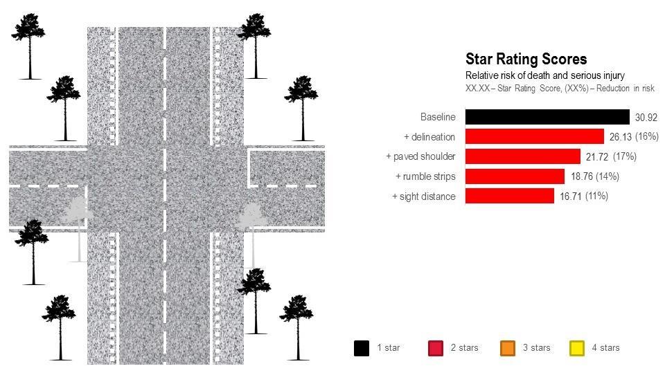
70 70
DEVELOPMENT OF ROAD INFRASTRUCTURE SAFETY FACILITY STANDARDS FOR THE ASIAN HIGHWAY NETWORK
 DEVELOPMENT OF ROAD INFRASTRUCTURE SAFETY FACILITY STANDARDS FOR THE ASIAN HIGHWAY NETWORK Bangkok DECEMBER 2017 The views expressed in this publication are those of the authors and do not necessarily
Setting Regional and National Road Safety Targets
 10 th Meeting of the United Nations Road Safety Collaboration 3-4 June 2009, Bangkok Setting Regional and National Road Safety Targets Commemorating 60 years in Thailand 1949-2009 Lives at stake people
Interim Report on the Development of Road Safety Infrastructure Facility Design Standard for the Asian Highway Network
 Development of Road Infrastructure Safety Facility Standards Expert Group Meeting on Asian Highway United Nations Economic and Social Commission for Asia and the Pacific 3-4 October 2016 Interim Report
irap irap The world road safety problem irap Background irap Aims A Safe Road System Vaccines for Roads 1. irap Background 2. irap Malaysia Results
 irap irap 1. irap Background 2. irap Malaysia Results Rob McInerney, CEO irap Asia Pacific 3. irap Worldwide 4. The challenge The world road safety problem A Safe Road System Road 1.2 million killed every
Road safety design standards and the Asian Highway Network. irap Asia Pacific Workshop Greg Smith 2016/05/26
 Road safety design standards and the Asian Highway Network irap Asia Pacific Workshop Greg Smith (greg.smith@irap.org) 2016/05/26 AH Standard Summary While developing the Asian Highway network, Parties
Road Safety in Asia and the Pacific and The Updated Regional Road Safety Goals and Targets for Asia and the Pacific
 Regional EST Policy Dialogue and Training Workshop for South Asia and South-East Asia 10-12 October 2017, Pathumthani, Thailand Road Safety in Asia and the Pacific and The Updated Regional Road Safety
Road safety status in ESCAP region and Regional road safety goals, targets, and indicators for the Decade of Action,
 United Nations Road Safety Collaboration Meeting Geneva, 5-6 October 2010 Road safety status in ESCAP region and Regional road safety goals, targets, and indicators for the Decade of Action, 2011-2020
BUILDING CHINARAP. Zhang Tiejun Research Institute of Highway (RIOH) Beijing, China
 Beijing, China") BUILDING CHINARAP Zhang Tiejun Research Institute of Highway (RIOH) Beijing, China E-mail: tj.zhang@rioh.cn Greg Smith International Road Assessment Programme (irap) Beijing, China E-mail: greg.smith@irap.org
BUILDING CHINARAP Zhang Tiejun Research Institute of Highway (RIOH) Beijing, China E-mail: tj.zhang@rioh.cn Greg Smith International Road Assessment Programme (irap) Beijing, China E-mail: greg.smith@irap.org
RECENT PROGRESS IN ROAD SAFETY IN THE ESCAP REGION
 RECENT PROGRESS IN ROAD SAFETY IN THE ESCAP REGION A.S.M. Abdul Quium and Thanattaporn Rasamit 1 ABSTRACT Road safety in developing countries of the ESCAP region is a development issue of serious concern,
ROAD SAFETY PERFORMANCE REVIEW Capacity Building Workshop for Uganda. irap METHODOLOGY Racheal M. N. Nganwa AfricaRAP Lead 1 & 2 March 2018
 ROAD SAFETY PERFORMANCE REVIEW Capacity Building Workshop for Uganda irap METHODOLOGY Racheal M. N. Nganwa AfricaRAP Lead 1 & 2 March 2018 About irap: Registered charity Vision: a world free of high risk
Economics of Road Safety What does it imply under the 2030 Agenda for Sustainable Development?
 Presentation issued without formal editing FOR PARTICIPANTS ONLY 14 March 2017 ENGLISH ONLY UNITED NATIONS CENTRE FOR REGIONAL DEVELOPMENT In collaboration with Ministry of Public Works and Transport,
Star Ratings for the Strategic Road Network. Richard Leonard - Highways England
 Star Ratings for the Strategic Road Network Richard Leonard - Highways England Strategic Direction for Road User Safety 2 Delivery Plan Star Rating - Commitments We will ensure that by the end of 2020
Road Safety Data Availability in Asia
 Road Safety Data Availability in Asia Dongwoo Ha Chief, Transport Infrastructure Section Transport Division United Nations Economic and Social Commission for Asia and the Pacific (UNESCAP) hadw@un.org
THE IRAP ROAD SAFETY TOOLKIT A WEBSITE-BASED APPROACH TO ADDRESSING ROAD SAFETY PROBLEMS
 THE IRAP ROAD SAFETY TOOLKIT A WEBSITE-BASED APPROACH TO ADDRESSING ROAD SAFETY PROBLEMS Blair TURNER Principal Research Scientist, Safe Systems Division ARRB Group Ltd 500 Burwood Highway, Vermont South,
MDB Road Safety Initiative: A Development Priority
 MDB Road Safety Initiative: A Development Priority Every six seconds, someone is killed or maimed on the world s roads. Over 90 percent of these injuries occur in low- and middle-income countries. The
Development of the Technical Standard on the Road Safety Facility For the Asian Highway Networks
 Development of the Technical Standard on the Road Safety Facility For the Asian Highway Networks 2016. 10. 03 UNESCAP 1. Introduction 2. Concept 3. Technical standard (initial version) 4. Amendment UNESCAP
ROAD SAFETY DEMONSTRATION
 Shaanxi Mountain Road Safety Demonstration Project (RRP PRC 46042) ROAD SAFETY DEMONSTRATION A. Introduction 1. The Shaanxi Mountain Road Safety Demonstration Project (the project) is located in two prefecture-level
Star Rating Roads For Safety
 Star Rating Roads For Safety The EuroRAP Methodology Consultation version 16 September 2009 ` EuroRAP505.04 Star Rating Roads For Safety: The EuroRAP Methodology Page 2 About EuroRAP The European Road
Road safety status in the WHO South-East Asia Region, 2013
 Road safety status in the WHO South-East Asia Region, 2013 2013 (1) (2) (3) Key facts at a glance Road traffic crashes accounted for 334 815 deaths in the South-East Asia Region during 2010, with the rate
Austroads National Risk Assessment Model (ANRAM) Chris Jurewicz, ARRB
 Chris Jurewicz, ARRB") Austroads National Risk Assessment Model (ANRAM) Chris Jurewicz, ARRB Overview Context What is ANRAM? How it is used? Severe crash risk estimation ANRAM Toolkit Next steps 2 Context Diminishing blackspots
Austroads National Risk Assessment Model (ANRAM) Chris Jurewicz, ARRB Overview Context What is ANRAM? How it is used? Severe crash risk estimation ANRAM Toolkit Next steps 2 Context Diminishing blackspots
Road safety. REGIONAL COMMITTEE Provisional Agenda item 8.5. SEA/RC70/11 Malé, Maldives 6 10 September July Seventieth Session
 REGIONAL COMMITTEE Provisional Agenda item 8.5 Seventieth Session SEA/RC70/11 Malé, Maldives 6 10 September 2017 21 July 2017 Road safety Road traffic injuries constitute a major public health burden with
CONCLUSIONS AND RECOMMENDATIONS
 CHAPTER 5: CONCLUSIONS AND RECOMMENDATIONS 5.1 General This chapter presents the conclusions and main recommendations flowing from the analysis of level crossing systems and safety performance in several
Discover the Safe System Approach
 Discover the Safe System Approach Aim Take you on a journey of discovery Inform, engage, enthuse and share with you the Safe System approach to saving death and injury on our roads Change to less graphic
The Safe System Approach
 There are very few areas of public discussion and sentiment which generate as much consensus as road safety. Everyone wants safer roads for all users, and road safety is a key priority for governments,
Road Safety Vademecum
 Road Safety Vademecum Road safety trends, statistics and challenges in the EU 2010-2013 March, 2014 European Commission DG for Mobility and Transport Unit C.4 Road Safety Contents Summary of findings...
The burden of road crashes on the health system in Asia Pacific
 The burden of road crashes on the health system in Asia Pacific Professor Peter F.M. Choong Sir Hugh Devine Professor of Surgery, University of Melbourne Department of Surgery Director of Orthopaedics,
INDEX. Geometric Design Guide for Canadian Roads INDEX
 Acceleration lane, see Lanes, Acceleration Access, 8.1 Access Management and Functional Classification 8.2 Access Management by Design Classification 8.3 Access Configuration 8.4 Building Set-Back Guidelines
Risk and Safety Assessment on Road Infrastructure. Olivera Djordjevic
 Risk and Safety Assessment on Road Infrastructure Olivera Djordjevic This presentation: How we score what we score Informed Investments Decisions: Safer Roads Investments Plans How it matters best case
ROAD SAFETY RISK MAPPING USING STRUCTURED DATA
 ROAD SAFETY RISK MAPPING USING STRUCTURED DATA DR. P K SIKDAR Jigesh N. Bhavsar* Advisor, IRF (India Ch.) and President, ICT Pvt. Ltd., A-8 Green Park, New Delhi, India 110016 Tel: +91-11-40863224; Email:
EGYPT: a national decade of action for road safety
 EGYPT: a national decade of action for road safety 2011 2020 Egypt EGYPT Population: 75 497 913 Income group: Middle Gross national income per capita: $1 580 INSTITUTIONAL FRAMEWORK Lead agency Funded
Post impact trajectory of vehicles at rural intersections
 Post impact trajectory of vehicles at rural intersections Doecke SD., Woolley JE. and Mackenzie JR. Centre for Automotive Safety Research Abstract This report describes the path of vehicles after a collision
URBAN KIWIRAP IDENTIFYING ROAD SAFETY RISK ON NEW ZEALAND S URBAN ROADS
 URBAN KIWIRAP IDENTIFYING ROAD SAFETY RISK ON NEW ZEALAND S URBAN ROADS C. BRODIE & F. TATE & R. MINNEMA New Zealand Transport Agency, New Zealand colin.brodie@nzta.govt.nz, fergus.tate@nzta.govt.nz, ron.minnema@nzta.govt.nz
Road Safety Annual Report 2016 OECD/ITF Chapter 26. Morocco
 Road Safety Annual Report 2016 OECD/ITF 2016 Chapter 26 Morocco This chapter presents 2014 road safety data for Morocco along with provisional data from 2015. It looks at trends in traffic and road safety
Economic and Social Council
 United Nations ESCAP/74/9 * Economic and Social Council Distr.: General 7 March 2018 Original: English Economic and Social Commission for Asia and the Pacific Seventy-fourth session Bangkok, 11 16 May
A Road Safety Decade - The Case for Action
 A Road Safety Decade - The Case for Action Presentation by Dmitry Sambuk International Coordinator, Make Roads Campaign, FIA Foundation Monday 12 May 2009, Minsk, Republic of Belarus World Report on Road
Road design and Safety philosophy, 1 st Draft
 Head Office SWEDEN www.vv.se Textphone: +46 243-750 90 Roger Johansson International Secretariat roger.johansson@vv.se Direct: +46 243 75880 Mobile: +46 70 6327373 Date: 2006-08-17 Reference: Road design
Trade in North-East Asia: State of Play
 Trade in North-East Asia: State of Play Andrea Goldstein ESCAP Sub-regional Office for North-East Asia Incheon, ROK Outline North-East Asia economies are open by global and Asian standards Trade growth
Introduction. 2
 Introduction In 2010, the United Nations General Assembly adopted Resolution 64/255 proclaiming 2011 2020 to be a Decade of Action for Road Safety. 1 In order to establish a baseline for the road safety
road safety issues 2001 road toll for Gisborne district July 2002 Road user casualties Estimated social cost of crashes*
 GISBORNE DISTRICT road safety issues July 22 The Land Transport Safety Authority (LTSA) has prepared this Road Safety Issues Report. It is based on reported crash data and trends for the 1997 21 period.
2003 road trauma for. Wairoa District. Road casualties Estimated social cost of crashes* Major road safety issues WAIROA DISTRICT JULY 2004
 WAIROA DISTRICT JULY 24 T he Land Transport Safety Authority (LTSA) has prepared this road safety issues report. It is based on reported crash data and trends for the 1999 23 period. The intent of the
Bicycle - Motor Vehicle Collisions on Controlled Access Highways in Arizona
 Bicycle - Motor Vehicle Collisions on Controlled Access Highways in Arizona Analysis from January 1, 1991 to June 30, 2002 Richard C. Moeur, PE Traffic Design Manager, Northern Region Michelle N. Bina
Chapter 5 DATA COLLECTION FOR TRANSPORTATION SAFETY STUDIES
 Chapter 5 DATA COLLECTION FOR TRANSPORTATION SAFETY STUDIES 5.1 PURPOSE (1) The purpose of the Traffic Safety Studies chapter is to provide guidance on the data collection requirements for conducting a
1 Monash University Accident Research Centre, Monash University, Victoria, RACV, 550 Princes Highway Noble Park, Victoria, 3174.
 Roadside Environment Safety: a statistical analysis of collisions with fixed roadside objects in Victoria Amanda Delaney 1, Stuart Newstead 1, Bruce Corben 1, Jim Langford 1 and Peter Daly 2 1 Monash University
Safe Speed programme ATTACHMENT 1. Randhir Karma, Group Manager Network Management and Safety
 Safe Speed programme ATTACHMENT 1 Randhir Karma, Group Manager Network Management and Safety 1 Why Safe Speeds? AT s strategic context National guidance AT has embraced Vision Zero principles and recognises
THE DEVELOPMENT OF MALAYSIAN HIGHWAY RAIL LEVEL CROSSING SAFETY SYSTEMS: A PROPOSED RESEARCH FRAMEWORK. Siti Zaharah Ishak
 THE DEVELOPMENT OF MALAYSIAN HIGHWAY RAIL LEVEL CROSSING SAFETY SYSTEMS: A PROPOSED RESEARCH FRAMEWORK Siti Zaharah Ishak Transport System Centre, School of Natural & Built Environments, University Of
Road safety in the Eastern Mediterranean Region
 Road safety in the Eastern Mediterranean Region Facts from the Global Status Report on Road Safety 2013 Road safety in the Eastern Mediterranean Region Introduction In 2004, the World Health Organization
REDUCING ACCIDENTS MEANS SAVING LIVES.
 REDUCING ACCIDENTS MEANS SAVING LIVES. "Almost 3500 people lose their lives on the world's roads every single day. It's a shocking figure. We can raise road safety standards significantly, and save lots
SECTION 1. The current state of global road safety
 SECTION 1 The current state of global road safety The number of road traffic deaths each year has not increased but remains unacceptably high at 1.24 million per year. Many countries have successfully
OVERVIEW OF CURRENT ROAD SAFETY SITUATION IN MALAYSIA
 OVERVIEW OF CURRENT ROAD SAFETY SITUATION IN MALAYSIA Mohamad Nizam Mustafa Highway Planning Unit Road Safety Section Ministry of Works Jalan Sultan Salahuddin 50580 Kuala Lumpur, Malaysia ABSTRACT Road
APPENDIX C. Systems Performance Report C-1
 APPENDIX C Systems Performance Report C-1 System Performance Report & Requirements According to the FAST Act, a long range transportation plan needs to include a system performance report and subsequent
June Presentation Title. Peter Daly RACV. Presenter s Name
 June 17 2008 Presentation Title Peter Daly RACV Presenter s Name Overview What AusRAP is and isn t What it is trying to achieve How it works Key results Future directions What is AusRAP? Sister program
BROADBAND CONNECTIVITY IN SOUTH EAST ASIA
 BROADBAND CONNECTIVITY IN SOUTH EAST ASIA ICT and Development Section ICT and Disaster Risk Reduction Division Asia-Pacific Information Superhighway Steering Group Meeting & 7 th Meeting of the Working
saving lives SWARCO The Better Way. Every Day.
 Reducing Accidents means saving lives SWARCO The Better Way. Every Day. Shutterstock REDUCING ACCIDENTS MEANS SAVING LIVES Almost 3500 people lose their lives on the world's roads every single day. It's
irap Star Rating and Investment Plan Coding Manual
 irap Star Rating and Investment Plan Coding Manual Drive on the right edition - August 2014 Setting the standards for the road coding process RAP-SR-2.2 PRINT WARNING printed copies of this document or
Institute of Transportation Engineers Safety Action Plan
 I Institute of Transportation Engineers Safety Action Plan 1. Introduction 2. Intersection Crashes 3. Keep Vehicles on the Road 4. Minimize Consequences When Vehicles Leave the Road 5. School Crossing
Economic and Social Council
 UNITED NATIONS E Economic and Social Council Distr. GENERAL 20 December 2006 ENGLISH Original: ENGLISH and FRENCH ECONOMIC COMMISSION FOR EUROPE INLAND TRANSPORT COMMITTEE Working Party on Road Traffic
Analyses and statistics on the frequency and the incidence of traffic accidents within Dolj County
 UNIVERSITY OF PITESTI SCIENTIFIC BULLETIN Faculty of Mechanics and Technology AUTOMOTIVE series, year XXIV, no. 28 Analyses and statistics on the frequency and the incidence of traffic accidents within
Guide to Road Design Part 3: Geometric Design Session I 18 October 2016
 Guide to Road Design Part 3: Geometric Design Session I 18 October 2016 Today s moderator Angela Racz Online Training Coordinator Knowledge Transfer - ARRB Group P: +61 3 9881 1694 E: training@arrb.com.au
Acknowledgements. Mr. David Nicol 3/23/2012. Daniel Camacho, P.E. Highway Engineer Federal Highway Administration Puerto Rico Division
 Daniel Camacho, P.E. Highway Engineer Federal Highway Administration Puerto Rico Division Acknowledgements Mr. David Nicol Director, FHWA Office of Safety FHWA Office of Safety http://safety.fhwa.dot.gov/provencountermeasures/
1.3.4 CHARACTERISTICS OF CLASSIFICATIONS
 Geometric Design Guide for Canadian Roads 1.3.4 CHARACTERISTICS OF CLASSIFICATIONS The principal characteristics of each of the six groups of road classifications are described by the following figure
Transport and Communications Bulletin for Asia and the Pacific
 Transport and Communications Bulletin for Asia and the Pacific No. 83 Designing Safer Roads ECONOMIC AND SOCIAL COMMISSION FOR ASIA AND THE PACIFIC ESCAP is the regional development arm of the United Nations
ESCAP revised road safety questionnaire template for data collection
 ESCAP revised road safety questionnaire template for data collection UN General Assembly resolution 64/255 of 2 March 2010 Para 17: WHO and the UN regional commissions to coordinate regular monitoring,
Cycling and risk. Cycle facilities and risk management
 Cycling and risk Cycle facilities and risk management Failure to recognize possibilities is the most dangerous and common mistake one can make. Mae Jemison, astronaut 6/11/2010 York Regional Council Cycling
Introduction Methodology Study area and data collection Results and recommendation Conclusion References
 Introduction Methodology Study area and data collection Results and recommendation Conclusion References It is formal procedure for assessing accident potential and safety performance in the provision
RURAL HIGHWAY SHOULDERS THAT ACCOMMODATE BICYCLE AND PEDESTRIAN USE (TxDOT Project ) June 7, Presented by: Karen Dixon, Ph.D., P.E.
 June 7, Presented by: Karen Dixon, Ph.D., P.E.") RURAL HIGHWAY SHOULDERS THAT ACCOMMODATE BICYCLE AND PEDESTRIAN USE (TxDOT Project 0-6840) June 7, 2016 Presented by: Karen Dixon, Ph.D., P.E., TTI Team: Kay Fitzpatrick, Raul Avelar, & Subasish Das Project
RURAL HIGHWAY SHOULDERS THAT ACCOMMODATE BICYCLE AND PEDESTRIAN USE (TxDOT Project 0-6840) June 7, 2016 Presented by: Karen Dixon, Ph.D., P.E., TTI Team: Kay Fitzpatrick, Raul Avelar, & Subasish Das Project
ENGINEERING DESIGN STANDARDS TO ENSURE ROAD SAFETY: EXPERIENCES FROM INDIA
 ENGINEERING DESIGN STANDARDS TO ENSURE ROAD SAFETY: EXPERIENCES FROM INDIA Atul Kumar 1 ABSTRACT The primary goal of designing roads with adequate standards is to achieve a safer transport facility for
Pedestrian Crosswalk Audit
 1200, Scotia Place, Tower 1 10060 Jasper Avenue Edmonton, Alberta T5J 3R8 edmonton.ca/auditor Pedestrian Crosswalk Audit June 19, 2017 The conducted this project in accordance with the International Standards
Safe System approach A beckoning perspective for children
 Plenary Session 1 Safe System approach A beckoning perspective for children Fred Wegman Emeritus Professor, Traffic Safety at Delft University of Technology, the Netherlands Traditional approach: for example
EXECUTIVE SUMMARY March 2013
 EXECUTIVE SUMMARY March 2013 An Application of Safe System Approach to Intersections in the Capital Region Progress Report Introduction The Capital Region Intersection Partnership (CRISP) was founded in
usrap: An Innovation in Data-Driven Safety Analysis
 Est. Dec. 2014 usrap: An Innovation in Data-Driven Safety Analysis Presented by: Bruce Hamilton, Roadway Safety Foundation Doug Harwood, MRIGlobal Webinar Logistics Duration is 11:00 AM - 12:30 PM Mountain
Title. Authors. Safety Benefits of Highway Infrastructure Investments (May 2017)
") Title Safety Benefits of Highway Infrastructure Investments (May 2017) Authors Douglas W. Harwood 1, Jessica M. Hutton 1, Zachary N. Hans 2, Reginald R. Souleyrette 3, Michael A. Fields 3 1MRIGlobal 2Iowa
Title Safety Benefits of Highway Infrastructure Investments (May 2017) Authors Douglas W. Harwood 1, Jessica M. Hutton 1, Zachary N. Hans 2, Reginald R. Souleyrette 3, Michael A. Fields 3 1MRIGlobal 2Iowa
Cycle traffic and the Strategic Road Network. Sandra Brown, Team Leader, Safer Roads- Design
 Cycle traffic and the Strategic Road Network Sandra Brown, Team Leader, Safer Roads- Design Highways England A Government owned Strategic Highways Company Department for Transport Road Investment Strategy
Review of Guidelines for Cycleway Safety Fencing
 Review of Guidelines for Cycleway 1.0 PURPOSE 1.1 This document is meant to provide a review of available reference documents for determining appropriate fencing requirements for cycleway paths and shared
Road Safety Infrastructure Facility Standards Indian Context
 Road Safety Infrastructure Facility Standards Indian Context Tony Mathew Road Safety Professional Advisor, IRF Tony.maths@gmail.com Contents AH & NH network in India Key Infrastructure Issues affecting
Proven Safety Countermeasures. FHWA Office of Safety January 12, :00 p.m. to 2:00 p.m. Eastern Time
 Proven Safety Countermeasures FHWA Office of Safety January 12, 2012 1:00 p.m. to 2:00 p.m. Eastern Time Introduction and Background While States should still be considering the application of all of the
Capacity of transport infrastructure networks
 Most infrastructure extension work is concentrated on roads. The total length of the motorway network has increased dramatically during the past two decades (about 3 % per year). Construction of the high-speed
Reduction of Speed Limit at Approaches to Railway Level Crossings in WA. Main Roads WA. Presenter - Brian Kidd
 Australasian College of Road Safety Conference A Safe System: Making it Happen! Melbourne 1-2 September 2011 Reduction of Speed Limit at Approaches to Railway Level Crossings in WA Radalj T 1, Kidd B 1
Speed Limits in the Hoddle Grid
 Speed Limits in the Hoddle Grid Recent History of speed limits March 2013 Docs # 7738485 1 Introduction Muncipalities have power to Erect speed limit signs BUT Municipalities DO NOT have the power to approve
Lincolnshire JSNA: Road Traffic Accidents
 Road Traffic Accidents What do we know? Summary A higher proportion of road traffic collisions in Lincolnshire result in death compared to other areas. This may be due to the types of road in the County
People killed and injured per million hours spent travelling, Motorcyclist Cyclist Driver Car / van passenger
 Cyclists CRASH FACTSHEET 27 CRASH STATISTICS FOR THE YEAR ENDED 31 DEC 26 Prepared by Strategy and Sustainability, Ministry of Transport Cyclists have a number of risk factors that do not affect car drivers.
Findings on the Effectiveness of Intersection Treatments included in the Victorian Statewide Accident Black Spot Program
 Findings on the Effectiveness of Intersection Treatments included in the Victorian Statewide Accident Black Spot Program Nimmi Candappa, Jim Scully, Stuart Newstead and Bruce Corben, Monash University
1 VicRoads Access Management Policies May 2006 Ver VicRoads Access Management Policies May 2006 Version 1.02
 1 VicRoads Access Management Policies May 2006 Ver 1.02 VicRoads Access Management Policies May 2006 Version 1.02 2 VicRoads Access Management Policies May 2006 Ver 1.02 FOREWORD FOR ACCESS MANAGEMENT
APPENDIX A: Complete Streets Checklist DRAFT NOVEMBER 2016
 APPENDIX A: Complete Streets Checklist DRAFT NOVEMBER 2016 Complete Streets Checklist MetroPlan Orlando s Complete Streets Checklist is an internal planning tool for staff to further implementation of
Policy Statement. Objective. Context. References and Supporting Documentation
 Policy Statement Subject Placement of Distribution Poles Along Roads With Speed Limits Not Exceeding 70km/h Approved by Robert Rogerson Signature & Date Distribution Standards and Policy Manager Authorised
High-risk rural roads guide
 Interim draft for use April 2011 NZ Transport Agency Foreword - High-risk rural roads guide Crashes on rural roads are a serious issue in New Zealand. The social and economic costs are high. The Government
CHECKLIST 2: PRELIMINARY DESIGN STAGE AUDIT
 CHECKLIST 2: PRELIMINARY DESIGN STAGE AUDIT 2.1 General topics 2.1.1 Changes since previous audit Do the conditions for which the scheme was originally designed still apply? (for example, no changes to
Pedestrian Safety in Cities
 Pedestrian Safety in Cities Priorities for India Geetam Tiwari MoUD Chair Professor, Coordinator, TRIPP Indian Institute of Technology Delhi, India URBAN MOBILITY INDIA 2013 IIT Delhi 2013 RTI in Urban
Economic and Social Council
 United Nations ESCAP/CTR/2018/7 * Economic and Social Council Distr.: General 6 September 2018 Original: English Economic and Social Commission for Asia and the Pacific Committee on Transport Fifth session
Road Safety Assessments. Lt. Bob McCurdy Williamson County Sheriff s s Office Marion, IL.
 Road Safety Assessments Lt. Bob McCurdy Williamson County Sheriff s s Office Marion, IL. Why Are We Here? 2005 US Traffic Fatalities = 43,443 1429 4329 1361 1616 1534 3504 1729 3543 Illinois Annual Fatallities
Road Safety Audit Evaluation of Typical Two Lane Divided Highway in Nigeria
 Vol. 1, No. 3, pp: 55-64, 2017 Published by Noble Academic Publisher URL: http://napublisher.org/?ic=journals&id=2 Open Access Road Safety Audit Evaluation of Typical Two Lane Divided Highway in Nigeria
Relative safety of alternative intersection designs
 Urban Transport XII: Urban Transport and the Environment in the 21st Century 379 Relative safety of alternative intersection designs L. C. Wadhwa 1 & M. Thomson 2 1 James Cook University Townsville Queensland
Lessons Learned from the Minnesota County Road Safety Plans. Richard Storm CH2M HILL
 Lessons Learned from the Minnesota County Road Safety Plans Richard Storm CH2M HILL May 21, 2014 Overview of the MN CRSP: Why Prepare Safety Plans for Local Systems? MAP-21: Requires states to address
6. BREENS/GARDINERS/HAREWOOD INTERSECTION - SAFETY IMPROVEMENT PROJECT
 6. BREENS/GARDINERS/HAREWOOD INTERSECTION - SAFETY IMPROVEMENT PROJECT General Manager responsible: Officer responsible: Author: Jane Parfitt General Manager City Environment DDI 941 8656 Michael Aitken
Local road mountable roundabouts are there safety benefits?
 Local road mountable roundabouts are there safety benefits? Nimmi Monash University Accident Research Centre Abstract Roundabouts are internationally accepted as being highly effective in improving safety
CHAPTER 1 STANDARD PRACTICES
 CHAPTER 1 STANDARD PRACTICES OBJECTIVES 1) Functions and Limitations 2) Standardization of Application 3) Materials 4) Colors 5) Widths and Patterns of Longitudinal Pavement Marking Lines 6) General Principles
Manifesto for a safe, efficient and sustainable transport in NZ
 8 January 2018 Manifesto for a safe, efficient and sustainable transport in NZ Movement is an alliance of organisations working to achieve a safe, efficient and sustainable transport system that provides
Toward Zero Deaths. Regional SHSP Road Show Meeting. Virginia Strategic Highway Safety Plan. presented by
 Toward Zero Deaths Regional SHSP Road Show Meeting presented by Virginia Strategic Highway Safety Plan December 1, 2016 1 Welcome & Introductions Purpose of the Meeting Objectives & Key Outcomes Agenda»
REGIONAL BICYCLE AND PEDESTRIAN DESIGN GUIDELINES
 REGIONAL BICYCLE AND PEDESTRIAN DESIGN GUIDELINES November 16, 2011 Deb Humphreys North Central Texas Council of Governments Bicycle and Pedestrian Advisory Committee Snapshot of the Guide 1. Introduction
Crash Patterns in Western Australia. Kidd B., Main Roads Western Australia Willett P., Traffic Research Services
 Crash Patterns in Western Australia Kidd B., Main Roads Western Australia Willett P., Traffic Research Services Abstract Examination of crash patterns is one way of identifying key factors on which focus
Walking and Cycling Action Plan Summary. A Catalyst for Change The Regional Transport Strategy for the west of Scotland
 Walking and Cycling Action Plan Summary A Catalyst for Change The Regional Transport Strategy for the west of Scotland 2007-2021 Strathclyde Partnership for Transport Contents Purpose...2 Issues, Constraints