2008 City of Seattle COMMUTE TRIP REDUCTION (CTR) BASIC PLAN
|
|
|
- Debra Norman
- 6 years ago
- Views:
Transcription

 and to facilitate the review and certification of the Plan by the Puget Sound Regional Council (PSRC)(RCW 7094l526 (6)(7) and State CTR Board.")
1 2008 City of Seattle COMMUTE TRIP REDUCTION (CTR) BASIC PLAN Agency: City of Seattle A note on the format of the 2008 CTR Basic Plan and GTEC Program: The City of Seattle used this template, developed and recommended by WSDOT, in order to assure reviewers for the funding agency that the City s CTR Basic Plan met the requirements of the State CTR Board and reflected the tenets of the Revised Code of Washington (RCW ) and Washington Administrative Code (WAC 46863) and to facilitate the review and certification of the Plan by the Puget Sound Regional Council (PSRC)(RCW 7094l526 (6)(7) and State CTR Board. Attachment A
2 TABLE OF CONTENTS I Introduction 3 II Assessment of the Land and Transportation Context 4 III Baseline, Goals and Targets 15 IV Planned Local Services and Strategies for Achieving the Goals 15 and Targets V Requirements for Major Employers 19 VI Documentation of Consultation and Public Outreach 21 VII Sustainable Financial Plan 23 VIII CTR Basic Plan Implementation, Structure, and Schedule 27 IX Growth and Transportation Efficiency Center (GTEC) 29 A. Executive Summary 30 B. Background 33 C. Goal Setting and Performance Measurements 37 D. Program Strategies 38 E. Sustainable Financial Plan 44 F: Organization and Implementation Structure 45 G. Public Outreach 48 H. Relationship to CTR Basic Plan 50 APPENDIX 51, 2
3 I Introduction 2008 COMMUTE TRIP REDUCTION BASIC PLAN In 2006, the Washington State Legislature passed the Commute Trip Reduction (CTR) Efficiency Act which requires local governments in those counties experiencing the greatest automobilerelated air pollution and traffic congestion to integrate into their long range, comprehensive and strategic plans their current and future plan to reduce trips in single occupant vehicles. The City of Seattle has prepared its CTR Basic Plan in accordance with RCW , WAC 46863, and the guidelines provided by the Washington State Legislature through the State CTR Board. The City of Seattle s CTR Basic Plan is a collection of goals and policies which, when combined with major facility and service improvements, will contribute to reducing drive alone trips and vehicle miles traveled over the next four years. The City will build upon the success of the existing CTR Plan (SMC 25.02) by continuing to work in partnership and coordination with employers, agencies and organizations that share its goals. The City adopted its first CTR plan in 1992 and updated it in 1998 and 2005, as goals and targets changed. In developing the 2008 CTR Basic Plan the City was mindful of the fact that over 250 major employers located throughout the City have been contributing to this effort for many years. The City of Seattle s 2008 CTR Basic Plan supports the City s vision, the goals of its Comprehensive Plan, and policies for the region developed by the Puget Sound Regional Council (PSRC), and expressed in Vision Note references in support of Vision 2020 are designated RT. Agency: City of Seattle Department: Seattle Department of Transportation Contact Person: Kathleen S. Anderson, Sr. Transportation Planner Administrator, Trip Reduction Programs Address 1: P.O. Box City: Seattle State: WA Zip Code: Phone #: Fax #: Address: kathy.anderson@seattle.gov A note on the format of the CTR Basic Plan and GTEC Program: In order to ensure reviewers that Seattle s CTR Basic Plan met the requirements of the Revised Code of Washington (RCW ) and Washington Administrative Code (WAC 46863) and to facilitate the review and certification of the plan by the Puget Sound Regional Council (PSRC)(RCW 7094l526 (6)(7) and State CTR Board, the City of Seattle used the template developed and recommended by WSDOT., 3
4 II. Assessment of the land use and transportation context Consistent with Vision 2020, RT8.17 and.20, this section describes Seattle s existing and planned land use and transportation context which will enable the City to meet its goals for reducing drive alone trips and vehicle miles traveled. General Statement: Seattle is a fully built city with a mature transportation system where land use and transportation are fundamentally related and are mutually supportive. Consistent with Vision 2020, the urban village strategy described in the City of Seattle s Comprehensive Plan (Comp Plan) recognizes the importance of multimodal concurrency and the land usetransportation relationship by focusing redevelopment in concentrated rather than linear patterns, directing transportation investments to link pedestrianoriented activity centers, and providing more opportunities for walking and bicycling within the centers. Over the last ten years, thirtyeight urban villages developed Neighborhood Plans to help support such development. These urban villages will also be priority areas for the City s investments in new capital facilities. While the existing CTR Plan is not called out separately in Seattle s Comprehensive Plan, the Comp Plan fully supports and has integrated TDM and CTR elements throughout its Land Use and Transportation elements. STATEREQUIRED INFORMATION A. Location of CTR work sites Most of the CTRaffected work sites are located in Seattle s designated Urban Centers, which appear on map #1, on page 3 of the Appendix to this document. The following table displays the number of CTR affected sites located in each urban center: B. Barriers to TDM Urban Center CTR Affected Worksites 1 Downtown (includes International District and Pioneer Square) Duwamish MIC 27 3 BallardInterbay Manufacturing and Industrial Center (MIC) 22 4 South Lake Union 21 5 First HillCapitol Hill 18 6 Northgate 7 7 Uptown 6 8 University Community 4 9 Not in an Urban Center 16 Total 254 General: The City of Seattle s Comprehensive and Transportation Strategic Plans integrated TDM policies with respect to land use, transportation facilities and services, and parking that will have the greatest effect on trip reduction. Although there are few policy or program barriers to the City s existing CTR Plan, there has been a gap in its funding. The number of CTRaffected work sites has grown from 220 in 1992 to 253 in 2007, while state funding to meet the state s requirements has remained at a constant level. The state has not increased funding for basic CTR Services to accommodate either normal inflation or growth in the number of affected sites that a jurisdiction must serve. There is a limited amount of local funding to coordinate CTR with other TDM programs (WAC (1)(b)), to implement Transportation Management Programs (TMPs), to engage managers and tenants of densely populated buildings, or to coordinate requirements of the State Environmental Policy Act (SEPA) with the City s CTR plans. TMPs are similar to CTR programs in that they are TDM programs that the City can require developers, property owners, and building managers to implement. Active implementation of a TMP extends incentives, products and services that can help reduce drive alone commutes to employees of small organizations that are not affected by the CTR Law and who otherwise would not have access to them. Lack of sufficient resources to support the development,, 4
5 implementation and coordination of TMP and CTR requirements undermines the intent of both the State Environmental Policy Act and the Washington Clean Air (CTR) Act. Data indicates that employees who do not receive trip reduction benefits or the same level of support for commute alternatives as those who work for CTRaffected organizations are 50% less likely to exercise nonsov commute options. Inability to coordinate TMP and CTR requirements results in duplication of effort and confusion for employers, reduces the City s capacity to extend TDM to employees of small organizations, can mean inconsistent or inadequate commute data, and diminishes transportation planning efforts. A major policy barrier is the federal tax benefit given by the Internal Revenue Service (IRS) to employers who provide parking for employees. This could be offset by a similar benefit to employers who provide mass transit benefits or removal of the parking benefit altogether. C. TDM Barriers by urban center. The City of Seattle asked CTRaffected employers in each urban center to describe any barriers to TDM that they perceive. Following is a summary of their responses: a. The Downtown Urban Center (DUC): Employers said that walking to and from the waterfront to major transit routes on First, Second, Third, and Fourth Avenues or from the ferry to worksites in the Central Business District (CBD) can be strenuous due to the significant grades, especially for those with mobility challenges. There are no north bound bike lanes, and bicycle access from the south requires riding in traffic, which can be challenging and intimidating for nonexpert riders. There is only one bike lane on a major arterial in the DUC, located on southbound Second Avenue, which can sometimes be obstructed by business loading that extends beyond the designated loading zones. In addition, cyclists are prohibited from loading bikes on buses within the Ride Free Zone, daily 7am to 6pm. These comments echo those received from the City during public forums held to address Center City Access. The City s response has been to develop a plan that will overcome gaps between existing systems and address intermodal connections and improve travel to and from key multimodal hubs and make them attractive destinations, including King Street Station, the ferry terminal, and the Westlake Hub. The City has identified both simple improvements that can be completed within a few years and longterm improvements that will be needed when major transportation projects are complete. For example, the City s 2007 Bicycle Master Plan and upcoming Pedestrian Master Plan will address many of these issues. Seattle s major transportation projects in the Downtown Urban Center are mapped on page 19 of the Appendix. b. First HillCapitol Hill Urban Center: Employers recognize that topography is the major barrier to pedestrians and cyclists who want to travel to the area from other parts of the city. They perceive the area as the most densely populated in the city, a neighborhood where transit service is frequent; pedestrian amenities abound and offstreet parking is relatively scarce and expensive. c. Northgate Urban Center: Many areas of this urban center do not have sidewalks that link work sites to transit stops, commercial centers and/or residential neighborhoods. Pedestrian amenities are limited, and the area is not bicyclefriendly. I5 divides this urban center and is a barrier between the transit center located immediately east of the freeway and major work sites located north and west of it. While there is frequent Metro Transit service for the general area and the Northgate transit center, there is no Community Transit Service between this urban center and Snohomish County. Only one transit route serves the Northgate transit center and east King County. Free parking abounds for retail use, and major employers like North Seattle Community College and Northwest Hospital provide large amounts of parking in order to prevent overflow of employee and student parking into surrounding neighborhoods. d. South Lake Union Urban Center: Employers in the neighborhood said that bus service to South Lake Union is limited, with few stops and shelters. They perceive few direct routes to the area and that express bus service is oriented to the University of Washington or Downtown; access by public transit typically requires at least one transfer, making transit commutes long and indirect. Major arterials are difficult to cross and pose major obstacles to pedestrians. Because traffic volumes are high, the street pavement often requires maintenance. Street damage and maintenance work often pose a hazard to bicyclists. Comments from the general public who attended public outreach forums which the City held in March 2007, asked the City to build the streetcar, make Westlake and Ninth Avenues twoway, increase and improve transit, including added connections to the regional transportation system, narrow Valley Street and make Mercer Street twoway, connect, 5
6 South Lake Union to surrounding neighborhoods and downtown Seattle, and to make South Lake Union more pedestrianfriendly. Since that time the new Seattle Streetcar began serving the area with 15minute headways; King County Metro is adding service to routes 70 and 8 in partnership with local employers; and Westlake has been converted to twoway, with Ninth Avenue to follow soon. e. University Community Urban Center: Major employers said there are few barriers to TDM in the area. The University is a major transit hub that is served by a number of local and express Metro and Community Transit routes. Employers said that offstreet parking is scarce and costly, and that pedestrian and cycling amenities abound. The University Area Transportation Study Update that was published in June 2007 cited more specific problem areas and inadequacies, such as: Lack of clear and complete designated pedestrian crossing on Roosevelt Way NE/11th Avenue NE at the Campus Parkway/Upper NE 40th Street intersection area. Lack of continuous bicycle lanes on Eastlake Avenue to Campus Parkway; lack of continuous pedestrian facility in this area. Bicycle/vehicle conflicts at the north and south ends of University Bridge: it is difficult for southbound bicyclists on Eastlake Avenue to make left turns at the Eastlake Avenue East and Harvard Avenue East intersection. Inadequate pedestrian facilities and unregulated parking on City properties and streets in the commercial area underneath the University Bridge. Lack of connection from Burke Gilman Trail to 40th Street/Campus Parkway in the area west of University Bridge. f. Uptown Urban Center: While a number of Metro Transit routes serve this area, coaches are often full, and most have standing room only during peak hours. Express bus service is generally oriented toward the Central Business District, passing by twelve major worksites located along Elliott Avenue and another 18 located on lower Queen Anne, where pedestrian amenities are plentiful. Cycling amenities are not ideal. While there are north and southbound bike lanes located on Dexter Avenue (east Queen Anne Hill) that connect the DUC with South Lake Union and the Fremont neighborhood, SR 99 is a barrier between Dexter and this urban center. Eastand westbound cycling is hampered by heavy traffic on Denny Way and Mercer Street, where there were no designated bikeways until the City provide the new bike lane on Roy Street. g. BallardInterbay MIC: The BallardInterbay MIC is large, with employers widely dispersed throughout. Small businesses are interspersed among larger businesses along the Ballard waterfront and Elliott Avenue West. Sidewalks and pedestrian access, which normally connect businesses together, are inconsistent, except in downtown Ballard. Transit service is infrequent along the Ballard waterfront, where larger employers are located, but improves with the approach to Market Street, where service to small businesses in Ballard s retail core is better. Express transit service, especially during peak hours, provides a good BallardDowntown connection, but skips most of the twelve major employers located along Elliott Avenue West. Some bus stops are close together; others are more widely dispersed. While there are sidewalks and a pedestrian overpass that serve the Amgen campus along Elliott Avenue West, pedestrian access along the Ballard waterfront is poor and there are few amenities to encourage pedestrian activity there. Elliott Avenue West is a major, sixlane, northsouth arterial with sidewalks along both sides, but opportunities for pedestrians to cross are limited. Bicyclists are better served by the Burke Gilman trail located along the Ballard waterfront, providing connections to the Elliott Bay Trail and worksites along the way. Load and unload zones provide easy dropoff access for van and carpoolers h. Duwamish MIC: The SODODuwamish area is large, and worksites are widely dispersed, with some worksites located in fairly remote areas beyond the boundaries of the MIC. Approximately 40,000 workers and 2,500 employers populate the area, which includes a total of 50 CTRaffected worksites, half of which are within the official boundaries of the MIC. A portion of the MIC is located in southwest Seattle, where the TDM programs of major employers continue to be challenged by the topography mainly steep hills and narrow roadways that limit transit service, pedestrian access and bicycle use. First Avenue South is the major northsouth arterial that provides transit service in this area. Eastwest transit routes are minimal, with South Spokane Street the major eastwest arterial. Pedestrian access is seriously limited, especially in the, 6
7 Duwamish area, and overall, there are few amenities to encourage pedestrian activity. Sidewalks are available to only about half of the worksites, and there are few sidewalks or pathways for eastwest pedestrian travel. There is inadequate street lighting, and there are no passenger shelters for transit riders. Narrow roadways prohibit transit service in most of the Duwamish, and where it exists the service varies widely. Employees at tech companies often work late and do not have transit options because service does not operate past peak hours. Service frequency south of South Spokane Street is longer than 30 minutes, and the distance a commuter has to walk to a bus stop can be uncomfortable, particularly in the winter time. The mix of freight and pedestrian traffic must be accommodated safely. Employees in the area have expressed concerns with personal safety due to inadequate street lighting and vagrant activity. Some worksites are located near residential neighborhoods, and others are located on narrow streets, which limit transit service. Distance between worksites and competition among employers limits rideshare arrangements. The large numbers of employees who speak English as a second language can make rideshare matching at different worksites a challenge. Workers who perform their jobs in the field away from the worksite or whose shifts end at odd times find it difficult to rideshare. D. Existing and planned land use conditions: The map on Page 4 of the Appendix displays the City of Seattle s existing and future land use conditions. The plan is described in detail in the City of Seattle Comprehensive Plan, a Plan for Managing Growth E. Existing and planned transportation facilities that support RT are displayed on the various maps that appear as exhibits in the Appendix; its Table of Contents provides a comprehensive list. 1. Street Network: The map on page 5 of the Appendix displays Seattle s street network and connections to ferries and to state and regional (highway) facilities. 2. Bikeways: The map on page 6 of the Appendix displays bike trails, designated lanes, and common bicycle routes. 3. Pedestrian facilities: The map on page 7 of the Appendix displays the City s sidewalk system. 4. Existing transit services and facilities: The map on page 9 of the Appendix displays Seattle s local transit service in relation to CTR and TMPaffected sites, including service to the City s urban and manufacturing centers. 5. Transit service: the tables on pages 1013 of the Appendix, are from King County Metro s SixYear Plan, and present Seattle s transit service in detail. Community Transit of Snohomish County also provides service into Seattle s urban centers. The map on page 14 of the Appendix, displays Community Transit service. The map on page 15 of the Appendix displays Community Transit Service to Seattle, Sound Transit bus and commuter train service. F. Existing parking conditions: Free parking and poor management of curb space can be barriers to TDM because free parking draws people from transit and other transportation alternatives. While there is significant unrestricted, free parking in the public rightsofway in most residential neighborhoods, most urban villages have some level of onstreet time restrictions, and paid, timelimited parking exist throughout Seattle s Center City and in several additional urban village areas. There are over 55,000 offstreet parking spaces in the downtown area, mostly in private parking facilities that sell them primarily as allday or monthly commuter parking. G. Policies Adopted and Actions Taken to Eliminate Barriers. Consistent with RT8.13, in 2004 the City conducted the TenYear Update of its Comprehensive Plan. Transportation Strategic Plan was updated in Both plans include policies that incorporate and support CTR. Consistent with WAC (1), Seattle adopted the following TDM policies into its Comprehensive and Transportation Strategic Plans in order to eliminate or mitigate the barriers described in I.B.15, above. These policies already have contributed to the reduction of commute trips, and will continue to do so as the City implements them in more neighborhoods. 1. Land Use: Comp Plan and TSP strategies that support RT8.17 include: a. Set offstreet parking requirements to reduce reliance on automobiles, promote economic development, and reduce housing costs. b. Encourage the use of alternatives to single occupant vehicles and the use of smaller, more energy, 7
8 efficient automobiles through the City s regulation of parking, including the amount of parking required, design of parking, location of parking, and access to parking. 2. Transportation Facilities and Services: Consistent with RT8.2,.4, and.18, the City s Comp Plan and TSP strategies include: a. Provide programs and services to promote transit, bicycling, walking, and carpooling to help reduce car use and SOV trips. b. Create a transitoriented transportation system that builds strong neighborhoods and supports economic development. c. Provide, support, and promote programs and strategies aimed at reducing the number of car trips and miles driven (for work and nonwork purposes) to increase the efficiency of the transportation system. Integrate pedestrian and bicycle facilities, services, and programs into City and regional transportation and transit systems. d. Encourage transit providers, the Washington State Ferry System, and others to provide safe and convenient pedestrian and bicycle access to and onto transit systems, covered and secure bicycle storage at stations, and especially for persons with disabilities and special needs. e. Provide and maintain a direct and comprehensive bicycle network connecting urban centers, urban villages and other key locations. f. Provide continuous bicycle facilities and work to eliminate system gaps. Consistent with RT 8.1, 8.4 and 8.8, the Seattle City Council adopted Ordinance stating guiding principles and practices so that transportation improvements are planned, designed and constructed to encourage walking, bicycling and transit use while promoting safe operations for all users. The ordinance also committed additional tax revenues to be generated from the newly adopted commercial parking tax, the business transportation tax, and the voterapproved property tax levy lid to fund: 1. Improved maintenance and rehabilitation of the City's existing transportation network, including its bridges, arterial roadways, signals and signs, sidewalks and stairways, bicycle trails, and street trees; 2. Enhancements that improve safety and enhance the opportunities for alternative transportation methods, including transit ridership, biking and walking; and a specific set of system enhancements including: upgrades to the Spokane Street Viaduct, construction of a new overpass on S. Lander Street, implementation of the Mercer Corridor Project, and the restoration and rehabilitation of the King Street Station. 3. Transit: Comp Plan and TSP strategies that are consistent with RT8.14 include: a. Work with transit providers to provide transit service that is fast and frequent. b. Pursue a citywide intermediate capacity transit system that connects urban centers, urban villages and manufacturing industrial centers. c. Pursue a citywide local transit system that connects homes and businesses with neighborhood transit facilities. d. Work with transit providers to design and operate transit facilities and services to make connections within the transit system and other modes safe and convenient. e. Integrate transit stops, stations, and hubs into existing communities and business districts to make it easy for people to ride transit and reach local businesses. f. Minimize negative environmental and economic impacts of transit service and facilities on surrounding areas. 4. Parking: Onstreet curb space is part of the public street system, and as such it is a public good that is available for all people to use. The Seattle Department of Transportation regulates the use of on street parking and curb space to address multiple and often competing needs. The goals of effective curb space management are to aid the efficient movement of people and goods, support the vitality of business districts, and create livable neighborhoods. Seattle s priorities for curb space use in business or commercial areas, including blocks with mixeduse buildings containing residential units, are, in order: transit use (bus stops and layover), passenger and commercial vehicle loading, shortterm customer parking (time limit signs and paid parking typically for one or two hours), parking for shared vehicles, and vehicular capacity. Strategies to achieve these goals include: a. Manage the onstreet parking supply to achieve vitality of urban centers and villages, auto trip reduction, and improved air quality., 8
9 b. Use paid onstreet parking to encourage parking turnover, customer access, and efficient allocation of parking among diverse users c. Consider installing longerterm paid onstreet parking along edges of commercial districts or in office and institutional zones to regulate curb space where shortterm p1arking demand is low. H. Review of Comprehensive Plan Policies. The Transportation Element begins on page 3.3 of the Comprehensive Plan with specific references to the Transportation Strategic Plan (TSP) and includes statements of policies and goals that incorporate and support the existing CTR Plan and RT To reduce car use, both the Comp Plan and TSP state that the City will employ land use policies and parking strategies that encourage increased use of transit, walking, biking, and carpooling. The plans also acknowledge that to be effective, the City must provide transportation alternatives and educate people about transportation choices and how these kinds of tools enable the City to manage or control the need to travel by car. Consistent with RT8.12, the plans state that transportation alternatives to driving alone need to address cost, convenience, and travel time. The plans also recognize that transportation needs and travel choices will change over time as alternatives to car travel become more viable. Both the Comp Plan and TSP have integrated the objectives of trip reduction by adopting TDM goals and policies. Page 34 of the Appendix provides a summary of TDM policies that appear in the Comprehensive Plan. I. Planning Coordination: The City of Seattle consulted with the following agencies when developing its CTR Basic Plan: Agency King County Metro CTR Services Community Transit King County CTR Coordinating Committee KC Metro Transit Sound Transit Puget Sound Regional Council Issues Scopes of work, employer services, administration, measurement, reporting, enforcement Transit service from Snohomish County to urban centers Interjurisdictional coordination Transit service and facilities Transit service and facilities Seattle s CTR Basic Plan and its regional impact J. Broad Assessment of Jurisdiction s Existing and Planned Land use, Transportation and Transit Conditions 1. Land Use: The City of Seattle s existing and planned land use conditions are displayed on the map on page 4 of the Appendix, and are described in detail in the City of Seattle Comprehensive Plan, a Plan for Managing Growth Transportation Facilities: Consistent with RT8.15, the City of Seattle developed its initial 1998 Transportation Strategic Plan (TSP) based upon information gathered at more than 40 community events, including meetings of District Councils, the Seattle Bicycle and Pedestrian Boards, and the Freight Mobility Committee. The City updates the TSP regularly, every two years, and made its most recent major revision in The TSP emphasizes mobility as a paramount issue for the City s economy, environment and the people who live in Seattle. Following the Comp Plan s 10Year Update that occurred in 2004, the most recently amended TSP specifies strategies, projects and programs that implement the broader citywide goals and policies for transportation in Seattle. Chapter 2 of the TSP describes Seattle s existing and planned transportation system, which contains a network of local, regional and state facilities that support an array of commute modes including transit, vanpooling, carpooling, bicycling and walking. Map #3 on Page 5 of the Appendix, displays Seattle s street network and connections to ferries and to state and interstate highway facilities; map #4 on Page 6 of the Appendix, displays bike trails, designated bicycle lanes, and common bicycle routes; and map #5 on Page 7 of the Appendix displays the City s sidewalk system., 9
10 3. Bicycle and pedestrian facilities. Pages 16 and 17 of the Appendix, maps #9 and #10, display walking and cycling patterns in Seattle from journey to work data provided by the US Census. Map #11 on page 18 of the Appendix displays the City s sidewalk inventory. Consistent with RT8.21 and 22, Seattle uses this information to help determine and prioritize improvements in pedestrian and cycling conditions. 4. Bicycle Master Plan (BMP): The Seattle Bicycle Master Plan is a set of actions to be completed within ten years that will make Seattle the best community for bicycling in the United States. Consistent with RT8.22, the City s increasing support for bicycling will make its transportation system more environmentally, economically, and sustainable. The Plan provides the framework for creating a Bicycle Facility Network and developing the facilities and programs that will make bicycling a viable choice for a wide variety of trips. Improving the convenience and safety of bicycling in the City will provide costeffective, healthy, and convenient transportation for residents who bicycle. It will also increase social interaction on streets, offer alternatives to driving on congested roadways, and reduce pollution public benefits that will make Seattle an even better place to live. a. Goals and Objectives of the BMP: The City of Seattle created a Bicycle Master Plan to achieve two goals: Goal 1. Increase use of bicycling in Seattle for all trip purposes. Triple the amount of bicycling in Seattle between 2007 and Goal 2. Improve safety of bicyclists throughout Seattle. Reduce the rate of bicycle crashes by one third between 2007 and To achieve these goals the City has identified four principal objectives to be supported by specific actions and performance measures that will enable the City to monitor progress over time. Objective 1. Develop a safe, connected, and attractive network of bicycle facilities throughout the City Objective 2. Provide supporting facilities to make bicycle transportation more convenient Objective 3. Identify partners to provide bicycle education, enforcement, and encouragement programs. Objective 4. Secure funding and implement bicycle improvements b. Characteristics of the Bicycle Network The Bicycle Master Plan recommends a 450mile network of bicycle facilities that will put more than 95 percent of Seattle s residents within onequarter mile of a bicycle facility, provide access across the waterways, freeways, and rail corridors that are currently barriers to bicycling, and create hundreds of miles of new bike lanes, bike routes, trails, and transit connections that will serve new and experienced riders. A Citywide Signed Bicycle Route System will connect all Urban Villages in Seattle A completed Urban Trails and Bikeways System that includes multiuse trails and streets with bicycle lanes that together form an interconnecting system. Shared lane pavement markings to indicate the proper direction of bicycle travel, encourage bicyclists to ride away from parked car doors, and to increase drivers expectations to see bicyclists on roadways Climbing lanes on hills to provide designated space for bicyclists on uphill slopes and encourage bicyclists to move away from parked car doors and share motor vehicle lanes on downhill slopes New bicycle safety treatments, such as warning signs, pavement markings, and traffic controls Bicycle and pedestrian bridges to make critical connections across barriers Exploration of new bicycle detection technologies at signalized intersections Bicycle boulevards A comprehensive bicycle route signage and wayfinding sign system: The plan will address the need for regional and local connectivity by recommending routes that would benefit from the addition of wayfinding signage. The plan will include recommendations for signed bike routes on, 10
11 City streets, sign design and spot sign placement such as streets leading to trails, bridges or popular destinations. c. ShortTerm Implementation (2007 to 2009). The BMP recommends the installation of 133 miles of new bicycle facilities within the next three years. While facility recommendations during this period may vary because many are tied closely to repaving projects, the City will focus immediately on key onstreet bicycle facilities, including 55 roadway crossing improvements, 106 miles of signed bicycle routes, 8 miles of new bicycle boulevards, 53 miles of shared lane pavement markings, and 37 miles of bicycle lanes and climbing lanes on arterial roadways. The City also will construct a key bicycle and pedestrian bridge (the Thomas Street Overpass) and add an additional two miles to the Urban Trails and Bikeways System. Partnerships for bicycle and pedestrian safety education, enforcement, and encouragement and bicycle transit access improvements will also be developed in this shortterm period. d. Plan Outcomes: Outcomes of implementing the BMP over the next ten years include: Bicycle facilities on 62 percent (295 miles) of Seattle s arterial streets A 230mile system of signed bicycle routes, connecting all parts of Seattle A signed route within ¼ mile of 72 percent of Seattle s schools 50 percent more (19 additional miles of new) multiuse trails A bicycle facility within ¼ mile of 95 percent of Seattle residents The complete text of the Bicycle Master Plan is available at 5. Pedestrian Master Plan: Consistent with RT8.21 and 22 and the City of Seattle s Comprehensive and Transportation Strategic Plans, the City began the planning process for its Pedestrian Master Plan in By the end of 2007, SDOT expects to have finalized the City s plans to: Build accessible sidewalk curb ramps. Install and maintain school crossing signs. Maintain, improve and install marked crosswalks. Install and maintain pedestrian crossing signs. Construct curb bulbs and crossing islands at pedestrian crossing locations. Rehabilitate and install sidewalks. Provide school walking route maps for Seattle's 60 public elementary schools. Address other pedestrian safety concerns. More information about the Pedestrian Master Plan is available on the internet at 6. Transit signal priority equipment: Consistent with RT8.8, by 2004 the City of Seattle was operating transit signal priority systems along segments of two major corridors: Rainier Avenue South and Aurora Avenue (SR 99) North. The system reduced bus delay on Rainier Avenue by 34 percent and improved travel time on Aurora by 22 percent. By 2006 the City provided Transit signal priority equipment at five intersections on Rainier Avenue South, 11 intersections on Aurora Avenue, five intersections on First Avenue South, and three intersections in the South Central Business District. Future plans include ten intersections along Lake City Way, one on Phinney Avenue North, two intersections on Jefferson Street, and two on South Jackson Street at Boren Avenue and at 12th Avenue South. 7. Transportation demand management programs. Consistent with RT8.11 and as required by what was the newly adopted State CTR Law, in 1992 the City adopted into the Seattle Municipal Code (SMC 25.02) a Commute Trip Reduction Plan that requires large employers to develop programs and provide incentives that discourage drive alone commutes. In 1998, the City developed Seattle s Transportation Strategic Plan (TSP), which provides a 20year functional workplan to accomplish the City s Comprehensive Plan goals. Among the strategies the TSP identifies to promote the use of alternative modes are public education efforts,, 11
12 proximate commuting, teleworking, parking cashout, bicycling, public transportation investment, and strengthening Transportation Management Program requirements for developers and property owners. Examples include: Vanpool Parking at the Fauntleroy Ferry Terminal Carpool Parking in the Downtown Urban Center Seattle in Motion One Less Car Program 8. Transit: Consistent with RT8.1, Planned and Potential High and Intermediate Capacity Transit Network and Seattle s Future Transit Network appear on page 18 of the Appendix as map #12, Seattle s Future Transit Network. Note: A rapid service connection replaced the Monorail Green Line using the same alignment. The change will need to be reflected in the City's adopted Seattle Transit Connections map consistent with work occurring on the West Seattle to Downtown and Ballard to Downtown bus rapid transit projects. The Seattle Transit Plan (including Seattle Transit Connections map) is likely to have its first major update when the TSP is updated in a. Regional Transit Service: The City of Seattle is served by Community Transit of Snohomish County, King County Metro Transit, Sound Transit and the Washington State Ferries System. These agencies provide an array of public transportation facilities and services, including local and express bus, commuter rail, vanpool programs, park and ride lots, and ferry service. Two light rail lines will serve Seattle in the first phase of regional Link Light Rail rapid transit service under the Sound Transit Sound Move tenyear plan. The City and Sound Transit expect the first phase of the Central Link, running from Seattle s Central Business District to SeaTac Airport, to be in operation in Maps that display these services and links appear on pages 14 and 15 of the Appendix. b. Local Transit Service: King County Metro Transit (Metro) provides Seattle s local and express transit service. Map #6, which displays Metro transit service in Seattle, appears on Page 8 of the Appendix. Metro provides Seattle with 1.89 million service (platform) hours and more than 60 million rides each year. Metro also operates the George Benson Waterfront Streetcar (currently being served by buses while the maintenance barn is rebuilt), the Seattle Streetcar s South Lake Union line, West Seattle Water Taxi and vanpool programs that serve Seattle and the region. Fixed transit routes and services. Pages A15 through A24, of King County Metro s SixYear Transit Development Plan for 2002 to 2007, contain the inventory of fixed transit routes and services in Seattle. Frequency and span of service. The inventory of spans, frequencies and planned changes in service appears on pages 9 13 of the Appendix. Transit facilities include transit centers, park and ride lots, bus stops, and passenger shelters. These are described in detail in King County Metro s SixYear Plan. Ridesharing services. King County Metro provides ridematch and support services to the region. In its SixYear Transit Development Plan for 2002 to 2007 (Revised November 2004) King County Metro describes its relationship to other plans and its intent to design and provide efficient service to major destinations and along corridors through an integrated network of service provided by Community Transit, Metro, Sound Transit, and the Washington State Ferries System. The Plan is available at c. Planned Transit Services and Facilities: Consistent with the Metropolitan Transportation Plan, Destination 2030, adopted by the Puget Sound Regional Council, the Six Year Plan proposes focusing transit services and facilities in urban areas and describes a multidestination service concept for connecting residential areas to core routes, transit hubs and activity centers. It also describes Sound Transit s limited stop, highspeed service between urban centers, peakperiod service via commuter rail and how access to service can be improved by improvements to walkways, bicycle storage and parkandride capacity. See map #12, Seattle s Future Transit Network, on page 18 of the Appendix., 12
13 In order to support this network, King County Metro s Six Year Capital Improvement Program (200207) for transit services and facilities includes regular bus stop improvements at locations throughout the system, a systematic approach to improving bus stops and facilities along core route corridors, and ongoing improvements to support service changes. Bus stop improvements are designed to help provide transit customers with comfortable, safe trips and to address the needs of transit vehicle operations. Locations are selected based upon community needs, operational requirements, ridership patterns, available budget, and service patterns. Bus stop improvements include a mix of the following components that improve the physical location where passengers wait, and affect stop location or related coach needs. Pedestrian and bicycle access upgrades to meet or exceed ADA standards, particularly where local jurisdictions make sidewalk improvements. Access is improved by constructing curb ramps, providing paved waiting areas, and improving sidewalk and pathway connections. Pedestrian safety issues and provision of bike racks is coordinated with local jurisdictions programs. Shelters and benches New passenger shelters, benches, new or upgraded translucent roofs to improve security. Lighting: New, improved or redirected lighting. Signage and customer information. Curb lane transit improvements. Bus stop spacing. Minor parkandride lot modifications. Other improvements: Detailed bus schedule information, art, community information, litter receptacles, special benches or other resting and seating structures, railings, and the use of buildings or awnings for weather protection. In addition to improving bus stop comfort and safety, the program establishes bus staging and layover facilities critical to service reliability and expansion. The complete text of King County s Six Year Plan is available at 9. Parking: The City of Seattle strives to balance the diverse and competing needs for parking, both on and offstreet, among employers, businesses, customers, and residents. Generally, the City works to discourage free, longterm commuter parking, especially in downtown Seattle, other Urban Centers and Urban Villages. Innovative parking regulations for offstreet development: In 2006, the City of Seattle passed Ordinance to update the Commercial Code. The Ordinance modified the City s offstreet parking regulations for commercial development outside of downtown Seattle in several critical ways: 1) Reduced minimum parking requirements to better match local parking demand; 2) Eliminated minimum parking requirements in the commercial zones in Seattle s Urban Centers and Light Rail Station Areas; 3) Encouraged shared shortterm parking in neighborhood business districts; 4) Established a maximum surface parking limit of one acre to reduce new impervious surfaces; 5) Revised bicycle parking requirements so that the number of parking spaces doesn t decrease when the number of required car spaces is reduced or eliminated; and, 6) Allowed carshare vehicle parking spaces to replace 3 normal spaces in new development. In 2006, the City also passed Ordinance to update the Downtown zoning code. This ordinance expanded the existing maximum parking requirement to all nonresidential uses at a maximum of one parking space per 1,000 square feet. Ordinance also requires developers to provide bicycle parking as well as shower and locker facilities, depending on the size of the new development. Onstreet parking management policies and priorities: Curb space management refers to regulating and prioritizing the use of the onstreet public rightofway for parking, loading, and other similar purposes. SDOT regulates the use of onstreet parking and other curb space to address what are often diverse and competing needs, and to aid the efficient movement of people and goods, support the vitality of business districts, and create livable neighborhoods. SDOT prioritizes the uses for curb space in business or commercial areas, including blocks with mixeduse buildings containing residential units, for transit use (travel lanes, bus stops and spaces for bus layover), passenger and commercial vehicle loading, shortterm customer parking, parking for shared vehicles, and vehicular capacity., 13
14 In residential areas the priorities for curb space use are: transit use (travel lanes, bus stops and spaces for bus layover), passenger and commercial vehicle loading, parking for local residents and for shared vehicles, and vehicle capacity., 14
15 III. Baseline Targets (RCW (4) (a) A. CityWide Goals and Targets: Consistent with RT8.13, in 2005 Seattle s Comp Plan and TSP established nondrive alone targets for each of Seattle s urban centers and an overall target for the City as a whole that is more aggressive than the CTR goals and which it hopes to achieve through the land use strategies and transportation programs that are outlined in its Plan: Urban Center 2000* 2010 Goal 2020 Goal Downtown 56% 62% 70% First Hill/Capitol Hill 31% 37% 50% Uptown/Queen Anne 33% 37% 50% South Lake Union 30% 37% 50% University District 56% 62% 70% Northgate 26% 30% 40% Seattle 39% 42% 45% * 2000 mode choice numbers are from the U.S. Census for the year 2000 journey to work data by place of employment. In 2007 the City of Seattle recalculated SOV and VMT targets for 2010 using new goals (10% reduction for SOV and 13% reduction for VMT) that were established by the State. Area of Jurisdiction 2005 SOV Rate 2010 SOV Target 2005 VMT 2010Target VMT Downtown Urban Center* 26.63% 23.97% 4.79 miles 4.16 miles Capital HillFirst Hill UC 41.64% 37.48% 7.07 miles 6.15 miles Duwamish MIC 61.54% 55.39% miles miles InterbayBallard MIC 59.67% 53.71% 9.25 miles 8.05 miles Northgate UC 71.87% 64.69% miles 9.60 miles South Lake Union UC 58.79% 52.91% 8.75 miles 7.62 miles University Community UC 46.12% 41.51% 7.55 miles 6.57 miles Uptown UC 57.73% 51.96% 9.06 miles 7.88 miles All Centers Overall 53.00% 47.70% 8.65 miles 7.52 miles Outlying Sites 44.45% 40.01% 7.36 miles 6.40 miles Seattle Overall 48.73% 43.85% 8.02 miles 6.98 miles *Note: The overall goal in the Downtown Urban Center will be revised to reflect the more ambitious goals and targets for the City s designated GTEC for B. Consistent with its RT8.13, the Comprehensive Plan and the 2006 Commute Trip Reduction Efficiency Act (RCW (4) (a) the City established new goals and targets for reducing single occupancy vehicle (SOV) rates and vehicle miles traveled (VMT) for each CTRaffected employer. See page 3943 of the Appendix. The targets displayed in the tables assume a 10% reduction from baseline in the drive alone (SOV) rate and a 13% reduction from baseline in vehicle miles traveled (VMT). Consistent with state guidelines, the City may adjust the goals and targets of individual worksites in order to achieve the overall goal established for the City overall or a given urban center. IV. Planned Local Services and Strategies for Achieving the Goals and Targets: Consistent with RT8.5 and RT8.1113, Seattle proposes to implement the following elements as part of its Commute Trip Reduction plan in partnership and coordination with other City departments and local and regional agencies. Listed below are the following planned local services and strategies for achieving trip reduction goals and targets by 2011 A. Policies, Plans and Regulations. In 2006 Seattle adopted an Employee Hours Tax to help fund major transportation maintenance and related projects, with deductions given to employers for employees who do not commute in single occupant vehicles. The City expects this policy, which took effect in 2007, to be an incentive that contributes to the use of public transportation and other alternatives to SOV commutes., 15
16 In 2006 Seattle also adopted a tax on commercial parking, although at the level currently taxed this is not expected to dramatically shift SOV commuters. In 2006 the City Council adopted Resolution relating to the Bridging the Gap transportation funding package restating the City s intention as described in the Transportation Strategic Plan and the Seattle Comprehensive Plan to encourage walking, bicycling and transit use as safe, convenient and widely available alternative modes of transportation. Section 3 of the resolution states the intent of the Mayor and City Council to work with the Seattle Department of Transportation to support the principles to provide appropriate accommodation for pedestrians, bicyclists, transit riders, and disabled persons and to incorporate these principles into the Department's Transportation Strategic Plan, Seattle Transit Plan, Pedestrian Master Plan, Bicycle Master Plan, and other SDOT plans, manuals, rules, regulations and programs as appropriate. When the City updates the Transportation Strategic Plan it will include the CTR Plan and explicit targets and goals for reducing drive alone trips and vehicles miles traveled. Community Parking Program: In 2008 SDOT will start working on the Community Parking Program a new program to work in 35 neighborhoods over the next seven years to study onstreet parking needs and implement a wide variety of improvements. Good parking management makes sure there are parking spaces available for short visits to local businesses, as well as for residents living in the area. It encourages people who need longer parking times to take the bus, bicycle or walk. Moving more people with fewer cars minimizes competition for onstreet parking, decreases congestion and reduces greenhouse gases in the air. To ensure the unique characteristics of each neighborhood are considered, the community is included in designing and conducting a parking study, generating a list of recommendations and implementing improvements. Once SDOT shares the final implementation plan with the community, changes to improve onstreet parking are made. Examples of regulations that may be changed or added include: Parking timelimit signs Commercial and passenger load zone adjustments, additions, removals Pay station installation Residential Parking Zone implementation Other creative parking solutions designed for neighborhoods In addition, the City will continue to incorporate trip reduction goals into its policies and plans at established amendment schedules. The proposed changes and their scheduled adoption dates follow. 1. Comprehensive plan policies related to TDM appear in the Appendix. Annual amendments to the Comprehensive Plan may be made in the fall of each year. No additional changes were proposed for Land use regulations related to TDM appear in the Appendix. Annual amendments to the Comprehensive Plan may be made in the fall of each year. No additional changes were proposed for Zoning code regulations related to TDM appear in the Appendix. Annual amendments to the Comprehensive Plan may be made in the fall of each year. No additional changes were proposed for Street design standards: Seattle is very progressive in its design standards. While the City s standards currently meet or exceed State requirements, the City plans to modify its standards and policies in the future within the context of the City's Complete Streets Initiative. This will make Seattle streets more accessible for all users and increase the transportation choices available. The Bicycle and Pedestrian Master Plans outline in detail the changes that Seattle will incorporate into its standards for work performed in the public rightofway., 16
17 5. Concurrency regulations. Section of the Seattle Municipal Code states the requirements to meet transportation concurrency level of service standards and states that the traffic forecasted to be generated by a proposed use or development will not cause the transportation concurrency level of service to exceed LOS standards. In addition, the urban village strategy described in the Seattle s Comprehensive Plan recognizes the importance of multimodal concurrency and the land usetransportation relationship by focusing redevelopment in concentrated rather than linear patterns, directing transportation investments to link pedestrianoriented activity centers, and providing more opportunities for walking and bicycling within the centers. This is consistent with and supportive of PSRC policy RT8.1 and 8.9. B. Services and Facilities While King County Metro provides Park and Ride facilities, transit, vanpool and ridematch services for the City, Seattle s Transportation Capital Improvement Plan for includes 30 projects and programs, totaling more than $237 million, that will reduce automobile dependence, drive alone trips and vehicle miles traveled. The largest projects appear in the table below, along with their implementation schedules. Again, note major investments in multimodal facilities that support PSRC policies RT8.1 & 2. TRANSIT FACILITIES Downtown Transit Tunnel Closure Mitigation $ 5.2million Completed 2007 Lake City Way N.E. Multimodal Project $13.2 million Sound Transit Construction Services $13.2 million South Lake Union Streetcar $45.0 million Completed 2007 University Way Multimodal improvements $ 7.5 million Completed 2007 Transit Corridor Improvements $22.5 million Aurora HCT & Pedestrian Improvements $19.7 million BICYCLE & SIDEWALK FACILITIES Bicycle Master Plan Implementation $18.3 million Ongoing program Bike Spot Safety Improvements $ 2.7 million Ongoing program Burke Gilman Trail Extension $18.4 million Chief Sealth Trail $ 3.5 million Completed 2007 Duwamish Bikeway $ 1.8 million Interurban Trail North $ 1.4 million Lake Union Ship Canal Trail $ 8.2 million $ Mountains to Sound Greenway Trail $ 5.3 million Completed Neighborhood Bike & Pedestrian Improvements $ 5.0 million New Sidewalk Program $ 2.2 million PedestrianBike Improvement Program $.5 million Ongoing West Lake Union Trail $ 5.1 million Completed Sidewalk Safety Repair $13.0 million Stairway Repair $ 2.8 million OTHER PROJECTS & PROGRAMS Duwamish Intelligent Transportation System $ 5.0 million Intelligent Transportation System Improvements $ 5.3 million Pedestrian Lighting $ 1.5 million TransLake Washington Project $.8 million Bike Trail Major Maintenance $ 1.2 million Annual Additional Transit Service $1.5 million Pedestrian Countdown Signals $.4 million Center City Access $ 5.6 million , 17
18 C. Marketing and Incentives Consistent with RT8.11, the City s CTR Plan requires employers to promote their programs regularly. CTR Services staff work directly with local employer networking groups to market incentives that reduce drive alone trips and vehicle miles traveled. Examples of the incentives promoted include: Transit pass discounts Home Free Guarantee (a subscription program) Parking cashout programs Preferential parking Flexible work schedules Compressed work weeks Telework and proximate commute options that allow working from home or alternative worksite D. Special Programs for Mitigating Construction Numerous construction projects have an impact on the City s transportation system each year. The major public works projects for 2006 and 2007 are displayed on Map #14, Page 20 of the Appendix. Seattle anticipates significant impacts on access, capacity and mobility from major projects like the Mercer Street revisions, Alaskan Way Viaduct replacement, Sound Transit s Light Link Rail, and SR 520 Bridge. City engineers and planners continuously engage in efforts that mitigate the impacts of these projects. The efforts include taking advantage of existing networks of CTRaffected employers as a useful tool for communication and providing employees with alternatives that contribute to mitigation efforts. Strategies for mitigating the impacts of construction vary with the unique conditions of the development and its location. To reduce the impacts of construction activities on mobility, the City restricts access to construction sites during peak commute hours and requires contractors to manage curb space and traffic according to plans that have been preapproved by the City s traffic engineers. The City of Seattle publishes a Traffic Control Manual for InStreet Work, a guide for establishing safe work zones that consistently and clearly convey to motorists, pedestrians and cyclists that work is being performed in the roadway. A copy of this manual is available at For large private developments that will have major impacts on traffic, the City requires proponents to assess and mitigate traffic impacts. Since 1985, the City has required proponents to develop and implement Transportation Management Programs (TMP) to reduce drivealone commutes by tenants. TMP requirements remain in place for the life of the building. Mitigation requirements must be met before, during and after construction. The City requires developers to produce traffic and parking studies that include estimates of the number of peak hour and daily trips that will occur during and after construction. The developer must estimate changes in levels of service (LOS) for affected intersections and meet the City s requirements for concurrency, adjusted for growth. The proponent must address transportation alternatives for private, singleoccupant vehicles, the availability and proximity of a variety of transit routes between the location and other areas of the City and region, and the scarcity and cost of parking that will make it likely that there would be fewer or more vehicle trips. A TMP template can be found on pages 2122 of the Appendix. For large, complex public works projects that require the taking of major portions of public rights of way, the City imposes conditions and standards for mitigating the project s impacts. For example, the proposal to construct and operate the light rail transit system requires proponents to analyze and assess long and shortterm effects on transit service, ridership, accessibility, roadways and land use. The analysis must consider the financial feasibility and costeffectiveness of alternatives. Once the impacts of the proposal are known, the City, project proponent(s) and appropriate stakeholders determine appropriate conditions and mitigations of impacts and how to provide them so as not to preclude the facility or render it impracticable. Seattle provided $5.2 million in to mitigate the construction impacts associated with the closure of the Downtown Transit Tunnel., 18
19 Center City Parking Program: In response to the expected largescale changes to onstreet parking in the downtown area, SDOT launched the Center City Parking Program in Major construction related to the Alaskan Way Viaduct and other transportation projects is expected to remove or restrict a significant number of the 5,000 paid onstreet parking spaces in the downtown area. Onstreet parking would be removed or restricted as a way to increase road capacity for transit, bicycles, freight, and necessary car trips. To address these anticipated changes to our critical supply of shortterm parking, SDOT is developing strategies for converting existing longterm onstreet parking spaces to shortterm use; moving commuters out of their cars to free up parking spaces, and identifying underutilized parking. Multiple strategies are needed to solve the problem because the demand for parking varies depending on nearby land uses and no one solution is the answer. The desired result is to provide easytoaccess parking with transparent pricing that keeps the Center City moving and contributes to a sustainable transportation system. The timeline is to be complete by 2012 when construction along the waterfront is expected to begin to replace the Alaskan Way Viaduct and seawall. V. Requirements for Major Employers (RCW (4) (b)(c)(d) Consistent with RCW , the City of Seattle existing CTR Plan is codified as SMC and establishes basic requirements for employers affected by the CTR Law. The City developed its 2008 CTR Basic Plan and Section IX, GTEC Program, in consultation with King County Metro, its local transit agency, representatives from local jurisdiction members of the King County CTR Coordinating Committee, including King County Metro and the Puget Sound Regional Council. The 2008 CTR Basic Plan remains consistent with RCW , requirements for CTRAffected employers: A. Designate Employee Transportation Coordinator (R) Each affected employer is required to designate a transportation coordinator to administer its CTR program and act as liaison to the City. An affected employer with multiple worksites may have one (1) transportation coordinator for all sites. The coordinator's name, location and telephone number must be displayed prominently at each affected work site; B. Regular Distribution of Information to Employees (R) Each affected employer must provide a complete description of its CTR program to employees at least twice a year and to each new employee when he or she begins his or her employment. Each employer's program description and report must report the information to be regularly distributed and the method and frequency of distribution. In addition the City encourages employers to provide employees with transit system maps and schedules, vanpool rider alerts, weekly traffic alerts, bike maps, and other HOV promotional information. C. Implement a CTR Program (R) 1. An employer's initial CTR program must include at least two (2) of the following TDM elements: Bicycle parking facilities and/or lockers, changing areas, and showers for employees who walk or bicycle to work, Commuter ridematching services to facilitate employee ridesharing for commute trips, Subsidies for transit fares, Employer vans or support for thirdparty vans for vanpooling, Subsidies for carpool and vanpool participation, Use of the employer's vehicles for carpool and/or vanpool commute trips, Alternative work schedules, a compressed work weeks and flexible schedules Preferential parking for highoccupancy vehicles, Reduced parking charges for vanpool vehicles, Cooperation with other employers and transportation providers to provide additional regular or express service to the work site (e.g., a custom bus service arranged specifically to transport employees to work),, 19
20 Special loading and unloading facilities for transit, carpool and/or vanpool users, No Park incentives, such as cash payments to employees who give up parking privileges. Institute or increase parking charges for SOVs, Telework options, Shuttle services between the worksite and parkandride lots, transit centers, or principal transit street, Attend at least four meetings of a local TMO, TMA or employer network group, Other measures that facilitate the use of nonsov commute modes. 2. The program also must include: a description of all program measures offered by the employer, the names of persons responsible for implementing the CTR program and evidence of commitment to provide appropriate resources to carry out the CTR program, a schedule of implementation, a general description of the worksite, including operational conditions which may affect an employee's choice of commute mode, a general description of the availability of transportation to the worksite, the total number of employees and affected employees at the worksite, and a list of the records to be maintained by the employer in implementing the program. Employers will maintain all records listed in their CTR program for twentyfour (24) months. D. Report Progress (R) Each employer is required to produce a report that includes a program description and submit it to the local jurisdiction for review and approval on a regular basis. Submittal: 1. An affected employer shall submit a CTR report on a date assigned by the City after reviewing the employer's initial CTR program. 2. At least thirty (30) days prior to the reporting date an employer may request a thirty (30) day extension to complete its report. This extension shall not change the normal reporting date for subsequent years. Content: The report shall include a review of employee commuting and of progress and good faith efforts toward meeting the SOV reduction goals. The report shall include: A description of each CTR program measure that was undertaken during the year; The number of employees participating in each of the CTR program measures; An evaluation of the effectiveness of the CTR program (summary report of survey results); and a description of proposed revisions to the CTR program that the employer intends to implement in order to achieve CTR goals; A description of the method and frequency by which the information required by the approved CTR program was distributed; A statement of the employer's method of measuring its VMT per employee, using either the average zonal trip length or the employer's average trip length from a survey. E. Measurement and Evaluation. Every two years each employer must conduct a survey of employees as described in the Washington State Commute Trip Reduction Task Force Guidelines and in conformance with SMC and achieve a seventypercent (70%) response rate in order to evaluate the worksite s progress toward meeting its CTR goals. Data on employees commuting behavior: 1. The employer must provide survey data or equivalent information. Employee surveys of commuting behavior will be the primary source of data about an employer's CTR program performance. Washington State Department of, 20
21 Transportation goal measurement questionnaires shall be used to measure affected employers progress towards goal attainment, unless the City approves equivalent information which is provided by the employer. 2. Instead of surveying all affected employees at a worksite, an employer may conduct a survey based on a sample of its affected employees if there are at least one hundred (100) affected employees at its worksite. The employer must demonstrate to the City that the sampling method is in accordance with generally accepted methods before the sampling is undertaken. 3. A minimum response rate of seventy percent (70%) of all affected employees in the population or seventy percent (70%) of the sample is required. When a seventy percent (70%) response rate is not achieved, an employer shall either: a. Provide supporting information, approved by the City, to document mode choice of affected employees. This information may include transit pass sales, records of rideshare subsidies, parking lot counts (where affected employees' actual commute trip behavior is measured between six a.m. (6:00 a.m.) and nine a.m. (9:00 a.m.)) when access and egress points are completely monitored; or b. Designate all nonresponses below seventy percent (70%) of the affected employee population or sample as SOV trips; or c. Use a combination of options (a) and (b). VI. Documentation of Consultation and Public Outreach (WAC (2)(ix) In 1991 The City of Seattle subjected its original CTR Plan to the public process it normally conducts for adopting city ordinances and amending its municipal code. Incorporating CTR & TDM into Seattle s Comprehensive Plan: (WAC ): In 2004 Seattle engaged in a public process to produce the Ten Year Update of its Comprehensive Plan that includes specific elements that are most likely to reduce drive alone commutes. (See the Comprehensive Plan Policies that appear in the Appendix, pages 3640.) Following are key dates of forums and hearings that the City held for that purpose. Community Forum, Fall 2004 Council member Peter Steinbrueck and the City Neighborhood Council (CNC) Neighborhood Planning Committee hosted a community forum on the Comp Plan and the 10Year update on Nov. 20, Council Public Hearing in Fall 2004 The City Council s Urban Development and Planning Committee held a public hearing in September to take public comments on the legislation and other potential amendments. Four Public Meetings Held in Spring 2004 Citizens were invited to four public meetings in April and May 2004 at Seattle City Hall to review the proposed amendments to the Comprehensive Plan and submit comments. Neighborhood Plan Steward Workshop Held in November 2003 A public workshop to discuss what the Comp Plan update process would mean to neighborhoods and Neighborhood Plan stewards was held on November 15, The workshop was cosponsored by the City of Seattle, the Seattle Planning Commission and the City Neighborhood Council/Neighborhood Planning Committee and was attended by City Council members, City Planning staff, and over 50 citizens KickOff Workshop Held in October 2003 A public workshop to kick off the 10year Comp Plan update was held October 14, Outcome of public workshops for CTR & TDM: One outcome of the public workshops was an issue paper that the Ten Year Update of the Comprehensive Plan addressed by incorporating and supporting CTR and TDM into the Comprehensive Plan. The paper, Seattle s Comprehensive Plan Update ISSUE PAPER #6: Mode Split Targets for Urban Centers, appears in the on page 30 of the Appendix, and the TDM policies that the paper generated in the Comprehensive Plan appear in Section II of this CTR Plan., 21
22 In 2008, the City will exercise the same process to amend its CTR Plan pursuant to the CTR Efficiency Act adopted by the Washington State Legislature in The City plans to adopt an ordinance, amending Chapter of the Seattle Municipal Code, in the first quarter of 2008 and to continue to engage stakeholders in its development. Beginning in 2006 the City invited the participation, review and comment from its 254 CTRaffected employers in the preparation of its Preliminary Draft of the 2007 Commute Trip Reduction Plan. Page 27 of the Appendix displays notices and other documentation of this consultation and public outreach. Additional Outreach and Coordination: 1. Interjurisdictional Coordination: Seattle had an opportunity to review and make comments on the Preliminary Drafts of the CTR Plans, including GTEC Programs proposed by the cities of Bellevue, Kirkland, Redmond, Shoreline, and Tukwila. The City coordinated the development and review of its own plan with representatives of jurisdictions and agencies that participate in the King County CTR Coordinating Committee: Auburn, Bothell, Burien, Federal Way, Issaquah, Kent, King County Metro, Puget Sound Regional Council, Renton, Shoreline, and SeaTac. 2. The City of Seattle engaged staff from several departments to address various issues related to the development of this plan. These include: Department Contact Issues: Planning & Development Tom Hauger, Kristian Kofoed, John Shaw, Mark Troxel Land use policies, Comprehensive Plan coordination, GMA, SEPA, TMP and CTR coordination Finance & Budget Stephen Barham Budget impacts, ordinance review Law Brent Lloyd, Sandy Watson Ordinance development Legislative Ernie Dornfield, Martha Lester, Plan and legislation coordination Transportation Transportation Committee Dorinda Costa, Michael Estey, Jon Layzer, Christine Patterson, Susan Sanchez, Kristen Simpson, MaryCatherine Snyder, Eric Tweit, Cristina VanValkenberg, Steve Viney, and Wayne Wentz Overall CTR Plan & GTEC Program Development, construction mitigation, concurrency, parking policies, capital and operating budget data, and management issues 3. WSDOT staff who participated in the development of this plan included Keith Cotton, Robin Hartsell, Brian Lagerberg, and Cathy Silns. They provided oversight for consistency with the State CTR Efficiency Act and W.A.C., state funding, CTR Board and legislative intent, and administrative guidelines. 4. Staff from the Puget Sound Regional Council, Lindy Johnson and Robin Mayhew, reviewed the plan and recommended that the state approve and fund the program. 5. In 2006 Seattle informed CTRaffected employers of the changes in the state CTR Law and discussed in more detail at quarterly meetings of CTREmployer Networking Group. In 2007 the City made its Preliminary Draft CTR Plan available and attended meetings with employers to discuss the effect of the CTR Efficiency Act. City staff also met with employers to discuss the City s new Employee Hours Tax and the tax deductions they could take for HOV use. 6. The Downtown Seattle Association participated in the development and review of the CTR Plan, especially Section IX, the GTEC Program. 7. King County Metro, Community Transit, Sound Transit and the Washington State Ferry Service staff provided information about local and regional transportation services and future planning. 8. In the development of the GTEC Program, Section IX, the City engaged the same participants named above, and also solicited input from tenants and the managers of denselypopulated properties located in the urban centers that will be the target market for the program. 9. Pages 2732 of the Appendix provide exhibits of the public outreach efforts for the plan., 22
23 VII. A Sustainable Financial Plan. (WAC (2)(g) Following is a description of the revenues from public and private sources that the City expects to have available, as well as the expected costs, to implement a CTR Plan and achieve its goals and targets. As employment and population grow, the City of Seattle expects the cost of implementing a CTR Plan will continue to rise and that the City will incur additional costs to implement the Plan. Anticipating that, the City will try new ways to implement CTR and related efforts, including any efficiency that the City might realize through operating one or more Growth and Transportation Efficiency Center (GTEC) programs. The City absorbed $60,000 in unanticipated planning costs in 2006 and 2007 and will rely upon WSDOT to provide funds for operating the CTR Basic Plan for By changing the way it works with CTRaffected employers located in the GTEC (See Section IX), the City hopes to realize savings in its basic program in the future. A. Funding Sources 1. CTR Basic Program Funding: WSDOT Basic Funding: $320,040 = $1,260 per site WSDOT Performance Funding: $ = 756 per site WSDOT Total Funding: $512,064 = 2,016 per site Estimated cost of Basic Services:$558,800 = $2,200 per site Gap in basic funding $ 46,736 = $184 per site* *Note: If the state does not provide performancebased funds, or find other sources of funding basic services, the Gap in basic funding will grow to $192,024 or $760 per site. 2. GTEC Program Funding WSDOT $300,000 per year Local Direct Funding Match $300,000 per year 3. Local capital investments in facilities that will support and complement a CTR plan appear on page 17. Local operating programs that will support and complement a CTR plan appear below: $625,000, Intelligent Transportation Systems Plan Implementation $100, Trans Lake Washington Project $6.5 million, Center City Access Strategy $200,000 provided by the City of Seattle for TMP development, implementation and enforcement, $300,000 provided by the City of Seattle, King County and Downtown Seattle Association for TDM $200,000 provided by the City of Seattle to operate a carpool parking program $ 27,000 provided by the City for its One Less Car program $ 69,000 provided by the City for its In Motion program, 23
24 July 1, 2007 December 31, 2007 CTR Basic Plan & GTEC Program Estimated Revenue Sources of Funds Use of Funding Responsible Agency Estimated Amount WSDOT Implement CTR Basic Plan City of Seattle/KCM CTR Svc $ 250,000 City/DTA/KC Metro GTEC Planning DUC City/DTA/KC M $ 150,000 TOTAL $350,000 January 1, 2008 December 31, 2008 Sources of Funds Use of Funding Responsible Agency Estimated Amount WSDOT Implement CTR Basic Plan City of Seattle/KCM CTR Svc $ 500,000 WSDOT CTR GTEC Implementation City of Seattle $ 300,000 DTA (City, KCM, DSA) CTRGTEC Implementation City of Seattle $ 300,000 TOTAL $1,100,000 January 1, 2009 December 31, 2009 Sources of Funds Use of Funding Responsible Agency Estimated Amount WSDOT Implement CTR Basic Plan City of Seattle/KCM CTR Svc $ 500,000 WSDOT CTR GTEC Implementation WSDOT $ 300,000 DTA (City, KCM, DSA) CTRGTEC Implementation City of Seattle $ 300,000 TOTAL $1,100,000 B. CTR Basic Plan and GTEC Program Costs 1. Administration. Plan administration includes meeting the state s basic requirements such as identifying and notifying affected employers, establishing baseline drivealone data, measuring progress and evaluating potential for improvement, reviewing employer programs and reports, providing training workshops, assistance, materials and tools that help develop, sustain and promote TDM programs. It also includes coordinating trip reduction management with neighboring jurisdictions, property managers, transit service providers, and sustaining organizations or agencies, meeting the state s reporting requirements and a cooperative approach to enforcement. 2. Facilities. Facilities include a wellmaintained transportation infrastructure and capital projects that help reduce the number of drive alone trips. Examples include high occupancy vehicle lanes, bicycle lanes, sidewalks, transit signal priority improvements, park and ride facilities and bus shelters. These support TDM and are not part of the operating costs of the CTR Plan or GTEC Program. They are funded by a variety of sources and are listed in VII.A.3, above. 3. Services that support transit and ridesharing include mass transit services, assistance with the formation of vanpools, car sharing and ride matching services provided by transit agencies. The City s Transportation Operating Fund (TOF) supports the development and implementation of Transportation Management Programs (TMPs) imposed on large land development projects during an environmental review process required by the State Environmental Policy Act (SEPA) in order to mitigate their impact on air quality, parking and traffic congestion. Seattle provides a number of services, including a carpool parking program, that directly support employers trip reduction efforts. To implement its CTR Plans the City of Seattle has contracted with King County s CTR Services Section to help major employers meet their basic CTR requirements. Staff meets regularly with representatives from neighboring jurisdictions who are members of the King County CTR Coordinating Committee to discuss common issues and determine best practices for managing them. Representatives from the regional transportation planning organization and WSDOT also attend these quarterly meetings. The cost of providing Transit Service in Seattle is provided and funded by a number of agencies and sources. It is not a part of the operating budget for the CTR Basic Plan or GTEC Program and, therefore, is not included in this financial plan., 24
25 Readers may refer to the Appendix to this document; pages 814, to view a complete description and mapped displays of current and planned transit services in Seattle. 4. Marketing. Marketing includes activities that promote and increase awareness of commute options. Activities include the workshops and training, the development and distribution of transit and ridesharing information, promotional campaigns, web sites that promote commute options programs, and outreach to employers. CTR Basic Plan and GTEC Estimated Revenue Summary Program Appropriation Funding Source CTR Basic Plan $512,000 State of Washington (WSDOT) GTEC Support $300,000 State of Washington (WSDOT) Total State Funding $812,000 Ongoing TDM Support Programs $516,000 City of Seattle TOF, KCM GTEC Program Operation $100,000 City of Seattle TOF GTEC Program Incentives $200,000 King County Metro GTEC Program Operation $100,000 King County Metro GTEC Program Operation $100,000 Downtown Seattle Association Total Local Funding $1,016,000 Grand Total Revenue $1,828,000, 25
26 CTR Basic Plan and GTEC Program Estimated Expenditure Summary Product, Service or Strategy Annual Cost Estimate Service Provider Funding Source CTR Basic Plan Meet state requirements; direct services to $450,000 KC Metro CTRS WSDOT affected employers Administer Basic CTR Program 62,000 City Admin WSDOT Subtotal Basic CTR Basic Plan $512,000 Supporting & Complementary Programs Carpool Parking Program 200,000 City of Seattle Seattle TOF One Less Car 27,000 City of Seattle Seattle TOF Seattle In Motion 69,000 City of Seattle Seattle TOF Ridematch Services (car & vanpool) 100,000 KC Metro KCMetro TMP Development & Administration 120,000 City of Seattle Seattle TOF Subtotal TDM Supporting Programs $516,000 GTEC Program* Administer Program to meet state requirements $ 75,000 City of Seattle WSDOT Direct Services to Participants 165,000 Contracting Partners WSDOT Measurement 50,000 Contracting Partners WSDOT Workshops and training 10,000 Contracting Partners WSDOT GTEC Program Management 300,000 Contracting Partners DTA Incentives 200,000 Contracting Partners KC Metro Subtotal GTEC Program* Costs $800,000 CTR Basic Plan & GTEC Program Total Cost $1,828,000 *The program budget for the GTEC appears in greater detail in Section IX, page Incentives Incentives include transit pass discount programs, subsidies for vanpool participation, and other contributions that employers can choose to encourage their employees to participate in commute options programs. 6. Training The City provides training workshops to teach transportation coordinators how to meet their basic CTR program requirements, including how to conduct surveys or alternative performance measures. Because the turnover rate among transportation coordinators is over 50%, Seattle concentrates most of its training efforts on these basic topics. Staff conducts training on effective program implementation and promotion through employer networking groups or as requested at individual worksites. C. Based on the revenue and expenditure assumptions (4. above), Seattle would not have a gap in funding for 2008., 26
27 VIII CTR Basic Plan Implementation Structure & Schedule A. The City of Seattle will continue to be responsible for developing and implementing its local CTR Basic Plan (SMC 25.02) and ensuring that it is consistent with the City s comprehensive plan, investments in new and improved transportation services and facilities, and with RCW and WAC Seattle will establish goals and targets for affected employers and ensure that they comply with the CTR Law. B. Seattle will continue to contract with King County Metro CTR Services to provide the following services for CTRaffected employers: Notify newly affected employers Provide ETC training and materials Monitor employers compliance with basic requirements for good faith effort Perform review of employer programs Manage and coordinate survey processes Collaborate to resolve compliance issues Analyze survey results and make recommendations for program enhancements Maintain data, documents and records Assist employers with program development and promotion Produce quarterly and regular progress reports C. Consistent with RT8.5, listed below are the organizations that would participate in the implementation of Seattle s CTR Basic Plan and their respective roles and responsibilities. 1. WSDOT: WSDOT is responsible for establishing the rules and guidelines for administering local CTR plans and distributing State grant funds for this purpose. 2. County: The City of Seattle contracts with King County Metro CTR Services to implement its CTR Basic Plan. Tasks include program review, ETC training, and direct marketing and incentive services to employers. See C. below. 3. Local Jurisdiction: The City of Seattle is responsible for developing a CTR plan that is consistent with its Comprehensive Plan, Transportation Strategic Plan, Land Use Code, State law, and corresponding rules and guidelines. The City is responsible for the general administration, implementation and enforcement of CTR plans. The City establishes goals and targets for affected employers and is responsible for ensuring that affected employers comply with the CTR law. For Plan implementation the City contracts with King County Metro CTR Services staff to provide direct services to CTRaffected employers. Under the direction of the City of Seattle s Administrator, CTR Services Staff identify affected employers, notify employers of their obligations under the law, and provide training to employers in how to develop, promote and implement CTR programs and how to measure performance. CTR Services staff review programs, measurements and reports; assess achievement and make recommendations pursuant to the City s CTR Basic Plan. 4. Contracting Partners: The staff of other departments, public agencies, or privatepublic partnerships with whom the City establishes working agreements to provide program services. 5. Transit Agencies are responsible for providing transit service and facilities, vanpool programs, as well as ridematching and ridesharing services. 6. The City of Seattle is responsible for conducting employer outreach activities, promoting drive alone options, educating employers and their employees about drive alone options, and administering special programs; e.g., transit discount programs, ETC training, program promotion, employer association, guaranteed ride home, etc. that will help affected employers make progress toward meeting their goals. The, 27
28 City may accomplish this by way of a contract with King County Metro s CTR Services Staff. 7. Employers are responsible for demonstrating a good faith effort by complying with the requirements of the State CTR Law and the City s CTR ordinance as provided in SMC Employers must designate an employee transportation coordinator, develop a CTR Program that they promote to employees at least twice each year, provide incentives and related promotional materials to employees, conduct biennial measures of their employees commuting behavior, report progress to the local jurisdiction, and implement new TDM measures that will help them achieve the goals and targets established by the City. 8. The City of Seattle administers its CTR plans and a CTR program for its own employees. The City contracts with its local transit agency, King County Metro CTR Services, to provide training, program review, and marketing incentives to all CTRaffected employers. 9. CTR Implementation Schedule Program Strategy or Service Agency Responsible Scheduled Date for Implementation Policies and Regulations City of Seattle Transit Services and Facilities King County Metro Sound Transit Transportation Infrastructure Improvements City of Seattle Center City Parking Management and other City of Seattle Parking Policies and Programs Marketing and Incentive Programs King County Metro Adopt CTR Ordinance City of Seattle 2008 Implement CTR Basic Plan & GTEC Program City of Seattle 2008, 28
29 IX Growth and Transportation Efficiency Center The City of Seattle requested and the State granted the designation of one or more GTECs and associated funding from WDOT in the amount of $300,000 in order to develop a TDM program for employers located in its Downtown Urban Center. In order to meet the requirements of the Puget Sound Regional Council (PSRC) and the Washington State Department of Transportation, Seattle will coordinate the development of its program with the PSRC. Following is Seattle s Proposed GTEC Program, which the City incorporated as Section IX of its CTR Basic Plan following public review and input, certification by PSRC, and approval by the State CTR Board. The City of Seattle proposes to designate its Downtown Urban Center (DUC) as a GTEC. A map that displays the area appears on page 31 of the Appendix. Introduction: The State of Washington has asked local jurisdictions to consider designating Growth and Transportation Efficiency Centers (GTEC) and to focus new CTR resources provided by the state in areas where jurisdictions also are making major investments in transportation infrastructure, capital projects, transit service, policies, especially land use policies, and programs that support the movement of the greatest number of people in the fewest number of vehicles. The City of Seattle has seven urban centers where it is making such major investments and meeting the criteria for a GTEC designation. Seattle s initial GTEC program would build upon its CTR Basic Plan to implement WAC (b) and address the gap described in Section IB of the CTR Basic Plan and Section IIE of this document. The City would take advantage of existing and planned institutional arrangements, organizations, services, and facilities to create a GTEC program that treats the designated area as a single CTRaffected worksite. A benefit that the City hopes to realize from this approach is that expenditures associated with sustaining TDM programs in the future may be only marginal additions to the total cost of providing basic CTR services in areas where the greatest density or growth is projected. By adding to the investment it already has made in transportation infrastructure, facilities and CTR Basic Plan for major employers, Seattle s GTEC program will have the advantage of economies of scalea more efficient way to achieve greater participation per dollar than may be possible for other jurisdictions. Seattle would exercise the TDM policies adopted in its Comprehensive Plan and Land Use Code and also offer TDM incentives, programs, products and services to commuters into the GTEC who otherwise might not receive them. Seattle would build its GTEC Program on new partnerships and existing networking groups of experienced, wellinformed CTRaffected employers who are guided by experienced staff who have a vested interest and longterm commitment to achieving the City s drivealone (SOV) targets. (WAC ) (WAC (2)(x) Areas in Seattle that now meet the state s criteria for funding a GTEC program are the City s urban centers and manufacturing and industrial centers: Downtown Urban Center, First HillCapitol Hill, Northgate, South Lake Union, Uptown, University, the BallardInterbay Manufacturing & Industrial Center, and the Duwamish Manufacturing & Industrial Center. These centers will realize the greatest growth in population and employment and are where plans and funding are already in place for increased transportation services, facilities and amenities for pedestrian and bicycle traffic. A note on the format of the CTR Basic Plan and GTEC Program: The City of Seattle is using the format template developed and recommended by WSDOT to ensure that its CTR Basic Plan meets the requirements of the Revised Code of Washington (RCW ) and Washington Administrative Code (WAC 46863) and to facilitate the review and certification of its CTR Basic Plan by the Puget Sound Regional Council (PSRC)(RCW 7094l526 (6)(7) and State CTR Board, 29
30 A. EXECUTIVE SUMMARY WAC 46863(2)(b)(i)(AD) 1. Vision of the GTEC program and how it relates to the CTR Basic Plan: The Downtown Urban Center (DUC) not only is densely populated with jobs, its residential population is projected to grow significantly in the next 1015 years. Adding to the effects of growth are the impacts that planned transportation construction projects will have on the interstate highways, state routes and local facilities that serve commuters who travel to, from and through the center. With these factors converging on one of the nation s most vibrant urban centers, the City of Seattle, King County and the local business community, through the Downtown Seattle Association, formed the Downtown Transportation Alliance (DTA), a partnership whose goal is to address community and economic vibrancy through mobility. The DTA established a significant goal to increase the use of nonsingle occupancy vehicle modes by six percentage points by This is greater than the SOV reduction goals established for the 133 traditional CTR worksites located in the center that represent only one third of the commuting population. The City of Seattle s proposed GTEC Program in its Downtown Urban Center would integrate its CTR Basic Plan with the DTA s Strategic Actions, which are: Fund/provide transportation services to meet emerging demands; Manage transportation resources, including parking supply and price; Maximize existing transportation investments; and Enhance user s awareness and experience for pedestrians, bicyclists, and transit users, as well as other transportation system users. Comparison of Trip Reduction Targets CTR Worksites v. GTEC Areawide NonSOV (45%) 69,750 Trips NonSOV (73%) 40,150 Trips Target (2.7%) 1,485 Trips SOV (24%) 13,365 Trips Target (2.7%) 4,185 Trips 155,000 GTEC Affected Commuters Travel Mode Data Sources: CTR Population 2005/06 WSDOT CTR Worksite Surveys Area Population 2005 UMG Survey As a catalyst for change, the DTA views the provision of service through the GTEC structure as one of the significant vehicles for achieving its overarching goal to support economic vibrancy through improved mobility SOV (52%) 81,065 Trips 55,000 Traditionally "Affected" Commuters at 133 Worksites 2. GTEC program goals and targets: The City recognizes that the market within the DUC has some of the best and most mature trip reduction programs, which have resulted in a drive alone rate of only 27% for CTRaffected employers. Building on these results, the DTA has established a macrolevel goal of a six percentage point shift from drive alone to nonsov travel by 2015 for the entire Seattle City Center (an area greater than the DUC). If the GTEC program is successful, Seattle would reduce the total number of drive alone trips by 4,200. That is 2,700 more trips reduced than would be achieved through the CTR Basic Plan s 10% reduction goal. The City would extend trip reduction efforts to the entire population of the GTEC, prioritizing the implementation of programs and services based on the highest trip reduction potentials. For some buildings, the City may leverage its regulatory authority under SEPA to engage managers of buildings with Transportation Management Plan (TMP) and their tenant populations in improving services and programs. The City would expand GTEC program efforts to other densely populated buildings and populations located in other urban centers as funding permits., 30
31 3. GTEC target population: The current CTR program reaches 55,000 commuters, or about one third of the DUC s 155,000 commuters. While the market within the DUC has some of the best and most mature trip reduction programs, which have achieved a drive alone rate of 27% for CTRaffected employers, the City of Seattle and its partners in the Downtown Transportation Alliance see an opportunity to reach a bigger market. a. The commuters, employers and commercial properties within the GTEC consist of the following market segments: Individual commuters Employers not currently affected by CTR and not in primary target buildings Employers currently affected by CTR Employers in major office towers. (Note: Fifty percent of all employees in the DUC work in the DUC s 75 largest buildings. This is a huge market and relatively few employers in these buildings have trip reduction programs.) b. This geographic area meets the criteria developed by the Puget Sound Regional Council for a GTEC: It is a designated urban center. Significant traffic volumes, capacity and/or delays have major affects on the region. Parking is scarce and costly. The City is making concurrent major investments in transportation networks, facilities and services. There are concurrent pedestrian and bicycle facilities, amenities and services. Land use conditions support TDM. Private organizations share the City s objective to achieve TDM goals and targets and provide TDM services to entities within the GTEC. Potential exists for making major reductions in SOV and VMT. 4. Proposed GTEC program: The City of Seattle s GTEC program is a major plan to market and deliver mobility programs, products, incentives and services that support the goals of the City and the downtown community. The GTEC will support mobility and access throughout the DUC and the major investments in public transportation facilities and services being made in the Downtown Urban Center over the same period of time (200811). To accomplish this, Seattle would engage an individual or organization a single point of contact whose task would be to establish access to new market(s). King County Metro s CTR Services and Market Development staff would continue to develop programs, products, and incentives and provide direct services that support these new markets. 5. Implementation a. Outreach: will consist of a multipronged approach and specific activities that provide: Resources for and directly to the commuter. Resources for all employers, but targeted toward those with the greatest potential for trip reduction. Resources for all properties, but targeted toward those with the greatest potential for trip reduction. b. Leverage: Using existing relationships and regulations to engage participants provides an opportunity to gain maximum efficiency in achieving trip reduction goals. Using these existing resources as the starting point enables a faster and more productive program from day one. (Examples include using current policies that support land use (TMP buildings) and transportation (CTRaffected employers within specified office properties) to demonstrate new outreach and service delivery initiatives.) c. Delivery: While the City of Seattle is the lead agency for establishing the vision and delivery parameters, it will continue to rely upon King County Metro to deliver programs and services, develop, 31
32 mobility solutions, conduct outreach, and increase awareness. Initially, affected CTR worksites will continue to maintain program report and survey functions, but these functions may shift to support measurement of the overall GTEC, subject to a collaborative planning process with WSDOT staff. d. Customer Contact: The programs and services will rely on frequent customer contact. Commuters have to see the program regularly to begin to rely on its services. Employers and property representatives must have regular contacts, service providers who maintain a very high level of professionalism and customer service. e. Measurement: The City intends to measure goal achievement in the GTEC by treating it as a single site, using a measurement tool and methodology that is approved by the state. f. Expand the Circle: As resources permit, the City would extend these products and services to property managers, and tenants and to other populations in the City s other urban centers that fit the criteria. g. Key funding and service partnerships: The source of funding for the operation of a GTEC would be provided by the State of Washington. The City of Seattle, King County Metro and the Downtown Seattle Association will provide up to $300,000 in local funding per year to support the program. The City and its partners will consider sustaining the operation of a GTEC program in future years if state funding for the initial program is adequate and the program is successful. 6. Benefits: Consistent with RT 8.8, eliminating 2700 more SOV trips would: a. Improve mobility and access to businesses and public facilities through the Center City during the construction of major projects and facilities, such as: Alaskan Way Viaduct and Seawall Replacement Sound Transit Light Link Rail system Multimodal hubs and transportation centers Colman Ferry Dock Revisions SR 520 Replacement I90 and I5 changes and improvements Other local transportation improvements. b. Reduce the demand for long term parking, thereby increasing the availability of the existing parking inventory for short term use. c. Offset the effects of population and employment growth on transportation infrastructure d. Improve air quality and reduce greenhouse gas emissions. e. Improve regional traffic. (Because Seattle s Center City is one of the region s most congested areas, reductions in congestion and traffic delay into and through the Downtown Urban Center would have impacts on traffic delay on roadways throughout the region.) f. Improve efficiency in the delivery of TDM products and services., 32
33 B. BACKGROUND INFORMATION WAC (2)(b)(ii)(AC) 1. Sources of Information Information Central Puget Sound Regional Growth Centers 2002 The Transportation Strategic Plan (TSP) Update City of Seattle Comprehensive Plan, A Plan for Managing Growth SixYear Transit Development Plan Parking, Your Guide to Parking Management Bridging the Gap City of Seattle Capital Investments Date Published 2002, PSRC 2005, SDOT 2004, City of Seattle, Dept. of Planning & Development 2004, King County Metro 2001, City of Seattle 2006, City of Seattle 2. Background Information a. Description of the geographic boundaries of the GTEC. Initially, the City of Seattle would designate a GTEC in its Downtown Urban Center. The Downtown Urban Center (DUC) consists of 952 acres of land that is bounded on the west by Elliott Bay, on the north by Denny Way, on the east by Interstate 5 and South Main Street and on the south by South Royal Brougham Way. The Downtown Urban Center includes Belltown, the ChinatownInternational District, the Commercial Core, Denny Triangle and the Pioneer Square Historic District. Seattle chose this as its first GTEC because: Employment density in the DUC is the greatest in the state. Reducing SOV and VMT in the DUC will make the greatest contribution toward reducing traffic volumes and delay on streets and highways. Citizen support for mass transit: Seattle and the region are making capital investments in mass transit infrastructure, transit service, and facilities that support bicycle and pedestrian access. Both the City of Seattle s Bridging the Gap and King County Metro s Transit Now funding initiatives gained voter approval in Both initiatives received substantial support from the DSA and individual downtown businesses. Policies of Support: Seattle s Comprehensive and Transportation Strategic Plans include land use, parking, and transportation policies that reduce the need to drive alone. Ordinance , Seattle's Complete Streets policy states guiding principles and practices so that transportation improvements are planned, designed and constructed to encourage walking, bicycling and transit use while promoting safe operations for all users. Local Organizational Support: The City of Seattle, King County Metro and the Downtown Seattle Association have formed the Downtown Transportation Alliance, which is committed to supporting this effort. CTRAffected Employers (112) participate in networking groups in order to share transportation information and promote trip reduction in the DUC. Local Funding: Up to $100,000 from King County Metro, $100,000 from the City of Seattle, and $100,000 from the Downtown Transportation Alliance, a total of $300,000 per year in direct funds. (Additional resources appear in Section E, Sustainable Financial Plan.) Expanding the CTR Basic Plan & GTEC Program: The City would focus its efforts on densely populated, highrise buildings, extending the programs and services it now provides to major employers to smaller employers. b. Documentation that the urban centers and proposed GTEC are located within the jurisdiction s urban growth area can be found in The City of Seattle Comprehensive Plan, a Plan for Managing Growth , 33
34 3. Land Use and Transportation Context (WAC (iii) in the Downtown Urban Center (DUC): Population: In 2004 the population of the DUC was 15,700 households, or 16 households per acre. In 2002 there were 165 jobs per acre, a total employee population of 156,960. a. Existing land use conditions: Seattle s Downtown Urban Center (DUC) is divided among the following primary land use functions: Office, retail, mixeduse commercial, mixeduse residential and harborfront. The DUC is fully built with a mature transportation system, where land use and transportation are fundamentally related and mutually supportive. The City of Seattle s Comprehensive Plan (Comp Plan) recognizes the land usetransportation relationship by focusing redevelopment in concentrated rather than linear patterns, directing transportation investments to link pedestrianoriented activity centers, and providing more opportunities for walking and bicycling. b. Existing transportation network. The DUC is served by Interstate Highways No. 5 and 90, State Highways 99, 509, 519, 520, and 522, the Washington State Ferry Terminal at the Colman Dock in the Central Business District, and the King Street Train Station. The DUC is served by Community Transit of Snohomish County, King County Metro Transit, Pierce Transit (Sound Transit operated) and Sound Transit, Amtrak, Greyhound and the Washington State Ferry System. These agencies provide an array of public transportation facilities and services, including local and express buses, commuter rail, streetcar routes, vanpool programs, park and ride lots, intercity bus and ferry service. Maps that display these services and links may be found in the Appendix, pages 8, 13 and 14. c. Economic development Plan. DUC: Seattle s Comprehensive Plan outlines a general economic development plan for the DUC with the goal of maintaining downtown Seattle as the most important of the region s urban centers a compactly developed area supporting a diversity of uses meeting the employment, residential, shopping, culture, service and entertainment needs of the broadest range of the region s population. 4. Projected Future Conditions and Characteristics that will contribute to reduced use of private vehicles in the GTEC. (WAC (iii)(b) a. Population and employment growth to the year The following tables display growth targets for the DUC to 2024: Downtown Urban Center HH Number HH Density Overall Employment Jobs Per Acre DUC Existing (2004) 15, HH/Acre 156, DUC Growth Target 10, HH/Acre 29, DUC Total Projected (2024) 25, HH/Acre 175, Traffic in Seattle is forecast to increase from 76 million VMT per day in 1998 to 106 million VMT in 2020, a 39% increase. To analyze the transportation effects of the Comp Plan s goals and policies, Seattle diverged from the traditional microlevel focus on intersection Level of Service (LOS) analysis in order to recognize the broader geographic impacts of development and travel patterns and to reflect the ability and behavior of motorists to select routes based upon a wide variety of factors. This yielded a forecast of Volume/Capacity (v/c) ratios that are below 1.0 standard LOS in the DUC. (Refer to page TA21 A27 of the Comp Plan for a complete discussion.), 34
35 Mode split/share: The 2000 Census reported the following commute mode splits in four of Seattle s urban centers: MODE Downtown South Lake Union First Hill/ Capitol Hill SOV 44% 70% 54% 66% Car or Vanpool 14% 14% 15% 13% Mass Transit 36% 10% 20% 14% Bike 1% 2% 1% 2% Walk 4% 3% 7% 4% Telework 0% 1% 2% 0% Other 1% 1% 0% 1% Uptown Seattle s investment in mass transit infrastructure, increased frequency of transit service, and improved facilities and amenities for bicyclists and pedestrians will significantly reduce reliance upon private vehicles and increase the use of alternative modes. Parking: Nationwide studies show that the price of parking is the most significant variable when making the decision to drive or use alternative transportation modes. A scarce supply of parking accompanied by a relatively high price is more likely to generate increased use of mass transit. People perceive parking as a scarce and costly commodity in downtown Seattle; however, the demand for parking is highly inelastic for commuters. Parking is expected to become more scarce and costly as employment and population grow and the cost of building parking versus other land uses increases. These circumstances will contribute greatly to shifts away from the use of private vehicles, making the DUC a viable target for promoting alternative commute modes. b. Forecasts of traffic delay. PSRC provided the City with the most recent forecast of traffic delay hours for 2010 for Interstate 5 and SR99. The boundaries for the forecast are: I5 from the Interstate 90 interchange to the SR 520 interchange; and SR 99 from Spokane Street to Mercer Street. HOURS OF DELAY 2010 Times of Day A.M. M.D. P.M. EV NI All Day Interstate 5 HOV NB SB GP NB SB SR99 HOV NB SB GP NB SB Totals by Time Period 1, , , , ,703.2 c. Plans, policies and capital projects. The City has committed $214 million in capital projects and programs that reduce the need to drive alone. (See page 23.) These include: A light rail line that will serve the Seattle Downtown Urban Center in the first phase of regional Link light rail rapid transit service under the Sound Transit Sound Move ten year plan. The first phase of Central Link, running from Downtown Seattle to the northern tip of the SeaTac urban center/seatac Airport is expected to be in operation in The City also plans to spend $1.8 million to raise the level of safety and visibility on bike trails that connect to the DUC. The City is developing a Downtown Transportation Plan., 35
36 The City is engaged with the State of Washington on a plan to replace the Alaskan Way Viaduct and Seawall. The City has made and will continue to make investments in nonmotorized transportation facilities such as installing pedestrian countdown signals along Pike and Pine Streets between First and Seventh Avenues in the DUC and implementing recommendations of the Bike Master Plan. Seattle has new transit and pedestrian improvements planned for Pike, Pine, Stewart, Olive and Howell Streets in The Alaskan Way Viaduct team is considering infrastructure and transit service investments that support transit operations in the CBD as part of a construction transportation mitigation plan that it is developing. In 2007 the City adopted an employee tax that allows employers to take deductions for their employees HOV use. e. Parking and Land Use: The City of Seattle strives to balance the diverse and competing needs for curb space uses generally, and specifically in downtown, and is working to ensure passenger and commercial loading where curb space parking is allowed. f. Center City Parking Program: To manage the loss of shortterm onstreet parking in the downtown area, particularly in the Central Waterfront, Pioneer Square and the retail core, SDOT is working with downtown stakeholders to convert a portion of existing offstreet parking from allday commuter parking to shortterm use. g. Minimum parking requirements: In 2006 Seattle passed Ordinance No , which eliminated the minimum parking requirements for nonresidential development in the downtown urban center. The Code also allows changes to the TMP to reflect current conditions and mitigate parking and traffic impacts. The ordinance established a maximum parking limit for nonresidential uses to a maximum of one parking space per 1,000 square feet. h. Bicycle Parking & Amenities: Ordinance No also changed the City s Land Use Code, to require developers to provide bicycle parking, showers and locker facilities in all new nonresidential structures over ten thousand square feet in the Downtown Core and to existing structures where more than ten thousand (10,000) square feet of nonresidential use is proposed to be added. 5. Gap Analysis. (WAC (2)(B)(iv) The CTR Basic Plan, Comprehensive Plan and Transportation Strategic Plan and the proposed GTEC Program describe Seattle s extensive investments in its transportation infrastructure, transit service improvements, cycling and pedestrian facilities, parking management, land use and transportation policies, and programs designed to reduce reliance upon automobiles for travel into and through the DUC. Summary descriptions of these investments appear on pages 5053; Seattle s parking policies and ordinances, street design standards and concurrency requirements appear on page 22; development and construction mitigation policies appear on page 24; exhibits of current transit service begin on page 8 of the Appendix; and a map of Seattle s Future Transit Network appears on page 18 of the Appendix. While these demonstrate that the City of Seattle already has made major investments in policies, programs and infrastructure that promote the use of mass transit and reduce reliance on the automobile, the City has identified a significant gap in its package of improvements, and that is the City s capacity to provide TDM support to large, densely populated buildings that house many small employers. With the advent of new and improved public transportation service into the DUC within the next two years, the timing is appropriate to make that effort now, 36
37 a. Services: A gap exists in the City s capacity to provide TDM products and services to small employers individually or in groups. With the implementation of LINK light rail in 2009, projected improvements to Metro Transit service, and higher utilization of existing transit capacity, Metro forecasts that sufficient transit capacity will be available to meet the GTEC s HOV goals through b. Policies: Although Seattle adopted transportation demand management into the land use and transportation elements of the Comprehensive Plan, the City has not included its CTR Plan as a standalone element of its Transportation Strategic Plan. There is limited local funding for CTR plans, for implementing Transportation Management Programs (TMPs), for ongoing monitoring and enforcement, or for engaging managers and tenants of TMPaffected buildings in order to coordinate their requirements with the CTR plans. c. Programs: Since 1980, the City has required owners and managers of certain properties to develop, implement and maintain transportation management programs, but does not provide significant funding to monitor their effectiveness, to coordinate these requirements with CTRaffected employers, or to assist building managers in the same way that the City provides services and products to major employers who are affected by the CTR Law. C. GOAL SETTING AND PERFORMANCE MEASUREMENTS WAC (2)(b)(v)(A) 1. Benefits: Reducing drive alone rates and vehicle miles traveled provides multiple direct and indirect benefits. These include reductions in congestion and improved mobility throughout the City and the region, and improved air quality. The GTEC program for accomplishing these targets is likely to be more efficient for CTRaffected employers and require fewer resources to serve them. The City of Seattle will offer CTR incentives, products and services at densely populated buildings and developments. This would enable the City to extend CTR to the larger population of employees of small organizations who otherwise may not have access to these resources. CTRaffected employers who occupy these buildings may take advantage of the buildingwide program to reduce their individual costs of promoting programs. If it works well, Seattle will meet its regional trip reduction goals as commuters take advantage of recent major investments in transportation infrastructure and services. 2. Proposed Goals and Targets for GTEC. A six percentage point reduction over the ten year period, ( ) would mean an average reduction of.60 percentage points per year, or a total reduction of 3.6 percentage points over the period , more ambitious goals and targets than the overall 10% reduction goal for the entire jurisdiction established by the State. Where a 10% reduction goal in SOV for the entire jurisdiction would result in an SOV target rate of 37.8%, a six percentage point reduction in the DUC would result in an overall SOV reduction goal of 21% and a target drive alone rate of 33.21%. Area DUC Base Drive Alone Rate 2005 SOV Reduction Goal Target Drive Alone Rate 2011 Base VMT 2005 VMT Reduction Goal Target VMT 2011 DUC CTR Aff. DUC TMPAff. 26% 38% 3.6% pt. 3.6% pt 22.40% 34.40% 4.73 Miles.62 miles (13.2%) 4.11 Miles DUC Non CTR TMP DUC All 43% 35.6% 3.6% pt 3.6% pt 39.40% 32.06% Entire Jurisdiction 42.0% 21.0 % 33.21% 7.06 Miles.92 miles (13%) 6.14 Miles, 37
38 3. Proposed Performance Measures WAC (2)(b)(v)(B) Target Population Proposed Performance Measure Proposed Schedule for Reporting Progress Commuters Most Recent CTR & TMP Commuter Survey or other measurement that is acceptable to WSDOT. Biennial survey and regular reports established by the state. D. PROGRAM STRATEGIES WAC (2)(b)(vi)(AC) 5. Proposed GTEC program: The City of Seattle proposes to provide CTR and TDM products and services to participants through its partnerships with King County Metro and the Downtown Seattle Association, with whom it has formed the Downtown Transportation Alliance. a. Orientation and introductions to TDM productions and services Education Marketing strategies Goals and targets Measuring Achievement b. Services available to participants: Training in the development and promotion of employer transportation programs Training in head tax deductions for HOV users; presentations to building managers for tenants PreTax training Training in how to take the HOV deduction from the Employee Hours (Head) Tax Employer networking opportunities Coordination among CTRaffected employers, nonaffected employers and worksites Transportation events Onsite Plan Your Commute trip planning sessions Rideshare online.com promotions with emphasis on carpool and vanpool formation c. Products provided to participants: Fully developed transportation web pages with links to KCMCTST transit routes and schedules, WSF ferry service timetables, commute cost calculators, ridematch on line, WSDOT Traffic Cams, real time traffic reports, area traffic alerts and delay information, bike routes and locations of facilities, vanpool formation services, and portals to other transportation services and information Templates for producing customized transportation information and materials for employees Home Free Guarantee Subscription Program, whereby employees who commute using HOV or nonmotorized modes have access to prepaid taxi service in case of an emergency Buildingwide trip reduction challenges, fashioned along the In Motion model report building wide results, provide buildingwide and/or individual incentives d. Incentives: Commuter subsidies for transit service Deductions from the City s Employee Tax Value added products and services provided to tenants and employees, 38
39 6. Implementation a. Outreach Assemble an inventory of highdensity (e.g., high rise, mixeduse) properties and contact information. This would include property owners and/or managers of buildings located within the GTEC boundaries, where large populations of small tenant businesses and nonprofits are housed. Develop contact and mailing list database ( , telephone, other contact media) from this inventory. Develop a similar list from the City s Department of Finance database of business licenses and employee numbers per employer. Purchase mailing lists of businesses operating in the GTEC and merge them with the inventory and mailing lists described above. Determine population and marketing potential. Sort the populations of employers for outreach and marketing purposes; e.g., CTRaffected employerstmp from nontmp affected building populations. Identify targets for outreach. Notify all targets of GTEC program: concept, idea, facilities, services, expectations and next steps. Outreach to private parking operators to provide HOV parking incentives or eliminate SOV incentives. b. Implementation: Leveraging Related TDM Requirements Inspect buildings and review existing TMPs for compliance, adequacy and effectiveness. Review buildings TMP requirements, survey results and managers efforts. Conduct baseline measurements (nonctraffected employers in TMPaffected buildings). Develop a TMP implementation subscription plan for property managers. Develop TDM marketing and promotion subscription services through King County Metro that facilitate building managers implementation and promotion of TMPs. (e.g., $10 per year per employee per building.) Market the TMP implementation subscription plan to management companies and/or managers of TMPaffected buildings: Contact property management companies and/or managers of TMPaffected buildings. Solicit subscriptions for TMP implementation. Solicit permission and support to market and provide TDMrelated services to tenants. Develop an outreach and marketing plan designed to engage the participation of small employers and property managers in the local CTRaffected employer groups. Expand the program to other densely populated buildings and entities as funding permits. Develop and market a similar subscription service for employers at nontmp affected buildings using KC Metro CTR Services or other service provider. c. Market TDM programs and services at densely populated buildings and developments. Produce and distribute centerfocused TDM and commute options promotional products. Produce and distribute model web pages for TDM and commute options access. Provide training opportunities to participants. Conduct site visits for the purpose of informing and promoting TDM. Conduct survey to measure performance since baseline. d. Expand the Circle: Extend outreach and TDM products and services to property managers, tenants and other populations in the City s urban centers that fit the criteria (in C above) as funding allows., 39
40 e. Key funding and service partnerships: The source of funding for the operation of a GTEC would be provided by the State of Washington. In addition, the Downtown Transportation Alliance will provide up to $300,000 to support this effort. 3. Proposed Target Population: (Described in Section 1.C.) 4. Policies and Regulations: Although the City of Seattle will not amend its Comprehensive Plan to include the CTR Basic Plan and GTEC Program (WAC (1)) as a stand alone plan, the Comp Plan includes the policies and regulations that are most likely to reduce drive alone trips and vehicles miles traveled. These begin on page 35 of the Appendix. Any changes to these policies and regulations would occur in 2010, when the City updates its Transportation Strategic Plan 5. Services and Facilities that support TDM and trip reduction: As part of its capital improvement program, the City provides transit facilities, HOV lanes, sidewalks, ramps, and bike lanes to facilitate pedestrian and cyclists access to transit service, thereby reducing drive alone trips and vehicle miles traveled. a. Seattle s Capital Improvement Plan for provides $237million in investments in projects that will help reduce drive alone trips and vehicle miles throughout the City, including the DUC. (See page 16.) The following ten projects will enhance the use of alternatives directly into and through the DUC: PROJECT VALUE SCHEDULE Downtown Seattle Bus Layover Facility $ 7.0 million Completed Downtown Transit Tunnel Closure Mitigation $ 5.2 million Completed Sound Transit Construction Services $13.2 million Completed South Lake Union DUC Streetcar $45.0 million Completed Westlake Multimodal Transportation Hub $.83 million Completed Intelligent Transportation System Improvements $ 5.3 million Pedestrian Lighting $ 1.5 million Trans Lake Washington Project $.8 million Completed Pedestrian Countdown Signals $.4 million Center City Access Strategy $ 5.6 million Total $78.53 million Consistent with RT8.8, the City also is working with its transit agency partners to increase and improve the following existing transit programs, services and facilities: i. High occupancy vehicle lanes. on Second, Fourth and Fifth Avenues ii. Transit services. Sound Transit s Light Link Rail Service will begin service in the fall of iii. Vanpool services and vehicles. iv. Ride matching services from King County Metro. v. Car sharing services: The City encourages employers and building managers to subscribe where it is likely to contribute to achieving the City s goals and targets. vi. Transit service and facilities provided by King County Metro, Sound Transit, Community Transit, Pierce Transit, and the Washington State Ferry System. In 2006 King County voters approved the Transit Now funding proposal to enhance transit services and facilities: Rapid Ride in key travel corridors: ShorelineDUC; West SeattleDUC, and BallardSeattle Center Stadium with: high frequency (< 10 minute), exclusive travel lanes, transit signal priority and queue jumps in key travel corridors: Improved shelter waiting areas with real time information at major stops 15minute frequency targets (all daytwo wayseven days/week) between the most densely developed activity centers. Bicycle and Pedestrian facilities: The City provides sidewalks, curbs and gutters throughout the Downtown Urban Center and has proposed expansion of facilities for bicycles and pedestrians. These as described in detail outlined in the Bicycle Master Plan and maps that are included in the, 40
41 Appendix to this document. 5. Marketing and Incentives: The jurisdiction must undertake the following tasks in order to implement marketing and incentive programs that will help reduce drive alone trips and vehicle miles traveled. a. Target outreach Assemble an inventory of contacts at highdensity (e.g., high rise, mixeduse) properties. This would include property owners and/or management companies and building managers within the GTEC boundaries, where large populations of small tenant employers (businesses and nonprofits) are housed. Determine population and marketing potential. Conduct broad promotions, DUCwide transportation events. Provide print and webbased promotional materials. Follow up with respondents Conduct buildingwide outreach and promotions at all major office properties. Maintain outreach and support to CTRaffected employers within the GTEC with possible transition to a more streamlined program in Expand program to other populations as funding allows. b. Implementation: The City would: Review existing TMPs for proposed changes that would make TMPs more effective. Review buildings TMP requirements, survey results and managers efforts. Expand to other populations as funding allows. Conduct baseline measurements (nonctraffected in TMPaffected). Develop a TMP implementation subscription plan for property managers. Develop TDM marketing and promotion subscription services through King County Metro that would facilitate building managers implementation and promotion of TMPs. (e.g., $10 per year per employee per building.) Market the TDM subscription plans to management companies and/or managers of densely populated properties: Contact property management companies and/or building managers. Continue to market transit pass sales and other TDM programs to worksites that are not CTRaffected and/or that do not have access to services via TMPs in affected buildings. Solicit subscriptions for TMP implementation. Solicit permission and support to market and provide TDMrelated services to tenants. Develop an outreach and marketing plan designed to engage the participation of small employers and property managers in the local CTRaffected employer groups. Coordinate building wide promotions coordinated with CTRaffected employers. CTRaffected employers are required to promote their programs twice each year, while TMPaffected buildings requirements vary. The City would coordinate the requirements of the two programs so that the promotions can occur at the same time and buildingwide. c. Incentives: Transit media discounts. The City would continue to promote the subsidy of transit passes by employers. Provide Shortterm Parking The City would encourage participation in the Center City Parking Program, including prioritizing providing shortterm parking over longterm daily and monthly parking. Parking cashout programs The City would continue to explain and promote the use of parking cashout programs to employers. Carpool subsidies, 41
42 The City would continue to promote temporary subsidies for carpools who may be trying ridesharing alternatives for the first time. The City would continue to promote employer subsidies for registered vanpools that are equal to the employer s support for public mass transit. Parking charges and discounts The City would continue to promote the market rate for all parking and the elimination of parking discounts, except for registered vanpools operated by local and regional public transit agencies. Preferential parking The City would continue to promote the dedication of preferential parking for registered vanpools and carpools. Flexible work schedules The City would continue to promote the use of flexible schedules by employers in order to allow employees to meet transit, carpool and vanpool schedules. The City also would continue to promote the use of compressed work weeks in order to eliminate commutes. Program to allow employees to work at home or a closer worksite The City would continue to encourage employers to consider workathome or proximate commuting and to promote their benefits in order to reduce commute trips. Individualized buildingwide marketing programs The City of Seattle and its partner, King County Metro CTR Services, would plan individual promotions and marketing programs to meet the needs of each target population. The partners would: Produce and distribute centerfocused TDM and commute options promotional products. Produce and distribute model web pages for TDM and commute options access. Provide training opportunities to participants. Conduct site visits for the purpose of informing and promoting TDM. Conduct surveys to measure baseline and improvements in performance. King County will explore providing transit pass and ridesharing incentives to employers. (See the program budget in Section 5.) King County will explore provision of incentives to individual commuters as well. 6. Schedule for Implementing Program Strategies and Services: The jurisdiction has identified the following schedule for implementing the GTEC program strategies and services. The agency responsible for implementing the strategy or service is also listed. Proposed Strategy or Service Agency Responsible Scheduled Dates for Implementation Policies and Regulations Adopt a GTEC Plan City of Seattle 2008 Revise SMC (CTR Plan) City of Seattle 2008 Update Transportation Strategic Plan City of Seattle 2010 Service Delivery Outreach to building managers Services to participants Product and incentive development Partner Contractor KC Metro CTR Services KC Metro MD January 2008 July 2010 January 2008July 2010 July 2007 January 2008 Market Incentives and programs KC Metro January 2008 December 2010 Provide services and programs KC Metro January 2008 December 2010 Develop and encourage participation City of Seattle January in the Center City Parking Program, 42
43 7. Proposed System for Measurement and Reporting: The City will use the stateprovided CTR survey instruments or other methodology approved by the state to measure and report progress of the GTEC program. Unless the City uses a different survey instrument and methodology, the University of Washington will continue to process the CTR surveys and report the results, which the City will record and report to the state. Staff will use the survey results to develop TDM programs that the jurisdiction will propose for each building. After two years the City will conduct the same survey and measure the performance over the initial (baseline) survey., 43
44 ACTIVITY E. SUSTAINABLE FINANCIAL PLAN (WAC (2)(vii) Financial information dedicated specifically for the GTEC appears below. The City of Seattle has identified sources of revenue and expenditures that would be associated with implementing a GTEC program. Expenditures include program administration, employer assistance, policy and regulation development, promotional activities, transit and ridesharing services, and implementation of supporting facilities. If anticipated funds do not become available to support the GTEC program, the City of Seattle would be unable to develop and implement this proposal. 1. Funding Sources a. WSDOT CTRGTEC Grant is the 2008 appropriation from the State to jurisdictions for the development and implementation of a GTEC program. The funding level is likely $300,000, which the City would use to operate, administer, measure and report on the success of its GTEC program. b. Local Jurisdiction Operating Funds and Capital Investment Program Funds: The City estimates the level of annual direct local funding will be $500,000. The City of Seattle, the Downtown Seattle Association (private partner), and King County Metro would provide $300,000 per year to develop and operate a GTEC program. In addition, King County will provide $200,000 for incentives. The City of Seattle has an employee tax that support reductions in SOV use. c. GTEC Five Year Sustainable Program Budget: Funding Source Year One Year Two Year Three Current Activities Base CTR Program DUC Employers WSDOT $140,000 $140,000 $140,000 $140,000 $140,000 City Direct Support Programs Carpool Parking Develop and Administer TMPs City of Seattle $200,000 $120,000 $200,000 $120,000 $200,000 $120,000 $200,000 $120,000 $200,000 $120,000 Employer Incentives KCM $200,000 $200,000 $200,000 $200,000 $200,000 Employer Outreach and Sales DSA / KCM $230,000 $230,000 $100,000 $100,000 $100,000 Subtotal $890,000 $890,000 $760,000 $760,000 $760,000 DTA Partnership (GTEC Match) City of Seattle King County Metro Downtown Seattle Association (Rent, Administration, Promotion, Measurement) City KCM DSA $100,000 $100,000 $100,000 $100,000 $100,000 $100,000 $100,000 $100,000 $100,000 Year Four $100,000 $100,000 $100,000 Year Five $100,000 $100,000 $100,000 Partnership Contribution Subtotal $300,000 $300,000 $300,000 $300,000 $300,000 WSDOT GTEC Request Administration Outreach Promotion Service Delivery WSDOT $75,000 $25,000 $100,000 $100,000 $75,000 $25,000 $100,000 $ $ 75,000 $ 25,000 $100,000 $100,000 $75,000 $25,000 $50,000 $100,000 $75,000 $25,000 $50,000 $50,000 WSDOT GTEC Request Subtotal $300,000 $300,000 $300,000 $300,000 $300,000 Total GTEC Program $600,000 $600,000 $600,000 $600,000 $600,000 Total Downtown Seattle TDM Program $1,490,000 $1,490,000 $1,360,000 $1,360,000 $1,360,000, 44
45 Following are potential sources of additional revenue to fund additional outreach, incentives, and services WSDOT TRPP Grants WSDOT OTM Regional Mobility Grants WSDOT OTM Construction Mitigation Federal STP, CMAQ or FTA Grants Private Sector Fee for Service Revenues d. Federal Funds: Seattle provided $5.2 million in to mitigate the construction impacts associated with the closure of the Downtown Transit Tunnel. e. Employer/Building Contribution Building managers at TMPaffected buildings pay $500 per biennium to participate in the survey process to capture mode split data for unaffected employers. Buildings implement TMPs or subscribe to CTRSprovided services. These funding sources include both financial and inkind contributions from employers. Beginning in 2007, employers will pay an employee tax based upon FTE or hours worked. F. ORGANIZATION & IMPLEMENTATION STRUCTURE (WAC (2)(viii) 1. Objective. The proposed organizational structure will include partners who share an overarching goal to provide a seamless experience for all customers of transportation demand management (TDM) services within the GTEC. The organizational structure for the Downtown Seattle GTEC is designed to: take advantage of expertise among the partner organizations; expand capacity to conduct outreach and promotional activities; streamline administrative and data management functions; and build and strengthen relationships with office property owners and managers. 2. Outreach. A distinguishing feature of the GTEC program is that it will need to reach employers that are not compelled to participate in programs by a regulatory (CTR) mandate. This will require an outreach strategy that is significantly different from the approach used in the base CTR program. The City of Seattle s GTEC program will depend heavily on its partners to conduct this outreach: The GTEC Partners The Downtown Transportation Alliance The City of Seattle The Downtown Seattle Association King County Metro The City has an established working relationship with the Downtown Seattle Association (DSA) and the Urban Mobility Group (UMG) because of their links to the owners and managers of office buildings in the Downtown Urban Center and to the business community at large. The Urban Mobility Group has a demonstrated track record that includes sales and delivery of transit pass products, and promotion of ridesharing and bicycling. The City of Seattle intends, subject to all applicable laws and agreements, to partner with the DSA and UMG to perform many of the tasks that will be essential to the success of the GTEC program. These include: initial outreach and primary point of contact for building owners and property managers scheduling of buildingbased activities outreach to professional organizations (e.g. Building Owners and Managers Association) data collection and management dissemination of information regarding improvements to transit service and other nonsov modes, such as bicycle commute information and support, carpool resource information, and updates on street improvements that also improve transit, 45
46 Because the outreach elements of the GTEC will leverage the efforts of partners and will expand existing organizational capacity, very little startup time will be required. The City of Seattle anticipates having outreach efforts underway within 60 days of the date when funding becomes available. 3. Promotional and Technical Support: Seattle s GTEC program will continue to depend on King County Metro to maintain relationships with major employers and to provide both technical and promotional services to all customers within the GTEC. These may include the following: building and employer site assessments (parking analysis, product availability) sitebased program planning training and workshops commute planning sessions transit pass/transit access product sales incentive program development and management Although the City of Seattle will rely on King County Metro for much of the technical support required for the GTEC program, it may also contract for specific expertise when warranted by a site s needs. Bicycle access and education programs and parking pricing and management strategies are examples of program areas where the City may seek additional expertise. Because many GTEC technical support functions will be delivered largely by an existing organization with trained staff, the City of Seattle anticipates that technical services will be available to the GTEC immediately upon funding availability. 4. Program Oversight and Administration. The Seattle Department of Transportation (SDOT) will retain program oversight and administrative functions. As the agency ultimately responsible for GTEC program delivery SDOT will perform the following tasks: develop protocols to ensure seamless delivery of services to GTEC customers review program activities to ensure client contact protocols are followed develop and manage contracts and agreements provide regular direction on program strategy and implementation ensure that SDOT s own TDM services are coordinated with the GTEC program when provided within the GTEC boundaries. coordinate with other City transportation projects and programs, including the Center City Parking Program and the Urban Mobility Plan development seek to coordinate TDM efforts of nonpartner agencies within the GTEC should any others intend to offer services within its boundaries (e.g. other transit agencies, private entities). work with the Puget Sound Regional Council to address interjurisdictional issues as necessary. Program oversight and administration activities will commence immediately upon GTEC funding availability. 5. Coordination with Other Jurisdictions. As part of its strategic plan for implementing the GTEC program, the jurisdiction plans to work in partnership with the Puget Sound Regional Council, local and regional transit agencies, and neighboring jurisdictions through the King County CTR Coordinating Committee. Following is an organization chart that reflects the various functional roles City of Seattle GTEC Functional Roles King County CTR Coordinating Committee City of Seattle Lead Agency Vision & System Needs Downtown Transportation Alliance Community Goals PSRC Regional Coordination Partner Contractor Market Access Partner Contractor Employer & Building Services Program Implementation WSDOT Compliance Legislative Liaison CTR Board Liaison 6. Comprehensive Plan Consistency. The City of Seattle s Comprehensive Plan policies and goals promote,, 46
47 complement and are consistent with the GTEC program goals. Section IX D.4.a (pages 5154) displays the elements of the Comprehensive Plan and Land Use Code that support the CTR Basic Plan and GTEC Program., 47
48 G. Public Outreach (WAC (2)(ix) 1. Background. In August 2006 the Washington State Rideshare Organization invited major employers throughout the state to attend allday forums to discuss the CTR Efficiency Act and GTEC Concept. In 2006 and early 2007, City representatives met quarterly with CTRaffected employers, soliciting information about barriers to successful TDM programs and achieving targets. These appear in detail in Section IIB, Barriers to TDM, in the CTR Basic Plan, and are summarized as follows: a. Policy barrier Tax Benefit for Providing Parking: If the IRS would remove the tax benefit to employers who provide employee parking and/or provide a similar benefit to employers who subsidize public transportation, employers would have a major incentive to provide and promote the use of public transportation regularly and frequently. b. Facility or infrastructure barriers: Poor pedestrian amenities and lack of sidewalks in many areas, poor pedestrian lighting, poor eastwest transit connections, poor connections from local to regional transit service, too few bikeways and cycling amenities, inadequate pick up and drop off facilities for car and vanpools, free parking in some areas, need for more frequent transit service so that buses are not overcrowded during commute hours. c. Coordination barriers: CTR resources and services have always focused on major employer worksites. Without resources to support the coordination of TDM efforts beyond the major employer, jurisdictions fail to reach large populations of commuters who could benefit from TDM products and services. d. GTEC Concept: The City of Seattle has considered more efficient ways to meet CTR requirements and how to stretch limited funding. Because of recent and planned major investments in transportation infrastructure and the advent of new and improved transit service, the City proposes to focus TDM efforts in more densely populated employment areas that are about to benefit from major transportation investments. (See Map #12, Appendix page 18). Building upon existing and planned facilities and services would strengthen the City s efforts to reduce reliance upon the automobile, and the City could realize economies of scale if it could have a buildingbased program that would reach more commuters than its current major employer worksite based program. e. Impact: Seattle s GTEC Program would be a newly designed marketing program directed at its Downtown Urban Center in time to promote and complement the use of new transit services and facilities and increase the incentives to use them. Its impact would be increased use of public transportation, bicycles, and high occupancy vehicles for commuting that would result in the greatest reductions in traffic congestion, air pollution, and traffic delays in the state. 2. Outreach a. Identified stakeholders: The City has identified managers of dense commercial properties and their tenants, CTRaffected employers, local and regional transit service agencies, adjacent jurisdictions, and providers of public goods and services. b. The City has provided communications materials that Inform stakeholders about the proposed GTEC program and how it is likely to affect them. In November 2006 staff provided CTRaffected employers with copies of WSDOT s brochure, Commute Trip Reduction Program, Implementing the CTR Efficiency Act and discussed the implementation process at CTR Employer Networking Group meetings. In 2007 the City will engage professional public information staff to develop and distribute appropriate materials that are tailored to the project. These may include the following: Producing and distributing information such as the GTEC Program Summary (See Appendix page 26.) Placing notices in newspapers; sending notices to stakeholders Developing project information web pages and links and providing them to stakeholders Developing subscription updates Providing speakers, 48
49 c. The City will engage employer groups to host meetings and workshops d. The City of Seattle was able to review the GTEC Programs proposed by the Cities of Bellevue, Kirkland, Redmond and Tukwila. Seattle developed its own GTEC Program in consultation with the following organizations and individuals: Agency Review CITY OF SEATTLE (1) Department of Planning and Development Contacts: Tom Hauger, Kristian Kofoed, John Shaw, Mark Troxel Issues: Incorporating TDM into Comprehensive Plan, Updates to the Land Use Code, TMP/SEPA Coordination (2) Department of Transportation Contact: Kathleen S. Anderson, Cristina Van Valkenburgh, Michael Estey, Mark Keller, Mary Catherine Snyder, Kristen Simpson Issues: GTEC boundaries, GTEC Funding, Organizational Structure of the GTEC Program, Construction Mitigation Funding; Parking policies and issues; Center City Projects (3) Budget & Finance Contact: Bill Adams, Steve Viney, Mel McDonald, Stephen Barham Issues: 2008 SDOT Budget, 2007 Employee Head Tax and Parking Tax (4) Legislative Branch Contact: Seattle City Council, Transportation Committee Issues: Ordinance State Government: WSDOT Contact Keith Cotton, Robin Hartsell, Cathy Silns, Casey Kanzler Issues: Implementing 2006 CTR Efficiency Act RTPO: Puget Sound Regional Council Contact: Lindy Johnson, Robin Mayhew Issues: 2006 Efficiency Act Implementation Neighboring Jurisdictions Contact: KC CTR Coordinating Committee (Cities of Auburn, Bellevue, Bothell, Burien, Des Moines, Federal Way, Issaquah, Kent, Kirkland, Redmond, Renton, SeaTac, Shoreline, Tukwila, and Woodinville) Issues: 2006 Efficiency Act Implementation and Coordination Employers: 133 Major, CTRaffected, Employers Contact: CTRaffected employers located in the DUC Issues: How the CTR Efficiency Act and a GTEC program option will affect implementation of their programs. Business Groups Contact: The Downtown Seattle Association CTR Employer Networking Groups; Downtown Transportation Alliance Issues: 2006 CTR Efficiency Act; GTECs and related programs; effect of GTEC and managing services to CTRaffected employers Transit Agencies Contact: Matt Hansen, David Lantry, CTR Services Staff, Market Development staff, Transit Service Planning Staff, GIS Services; Mike Bergman and Lisa Wolterink Sound Transit. Issues: Existing and planned local transit service; Sound Transit Support Reviewers can examine exhibits of the City s public outreach notices and products in the Public Outreach Section of the Appendix, beginning on page 26. Support for Seattle s GTEC Program: Pages 32 and 33 of the Appendix display copies of letters of support for the Seattle s proposed GTEC Program from King County Metro, its local transit agency, and the Downtown Seattle Association, a partner in this effort., 49
50 H: RELATIONSHIP TO LOCAL CTR BASIC PLAN Seattle s initial GTEC program would build upon its CTR Basic Plan to implement WAC (b) in order to address the gap described in Section IB and Section IIE of this document. The City would use existing and planned institutional arrangements, organizations, services, and facilities to extend trip reduction promotions and incentives to the entire population of an urban growth center. The City would use its authority in the Land Use Code, the State Environmental Policy Act to engage managers of SEPAaffected and densely populated (highrise) properties to coordinate CTR and TMP work. While SEPA requires some property managers to provide incentives that reduce trips at their buildings, the City has found that property managers make little or no effort to do this and are inconsistent in what they provide. The City and its partners would create and provide products, incentives and services and deliver them in a variety of formats to a building or groups of buildings whose tenants otherwise might not receive them. Seattle s GTEC Program would take advantage of existing workgroups that are comprised of experienced, wellinformed CTRaffected employers who are guided by welltrained, experienced staff who have a vested interest and a longterm commitment to achieving the City s drivealone (SOV) targets. (WAC ) (WAC (2)(x) The benefit of this approach is that expenditures associated with sustaining a GTEC program in the future may be only marginal additions to the total cost of providing basic CTR services in areas where the greatest density or growth is projected. By adding to the investment it already has made in transportation infrastructure and facilities, the CTR Basic Plan for major employers and GTEC program will have the advantage of economies of scalea more efficient way to achieve greater participation per dollar than may be possible through a CTR plan alone., 50
51 APPENDIX City of Seattle 2008 COMMUTE TRIP REDUCTION (CTR) BASIC PLAN, 51
52 Table of Contents Exhibit Title Exhibit # Page # 1 Map #1, CTR Sites 3 2 Map #2, Seattle s Current and Planned Land Use 4 3 Map #3, Seattle s Street Network and Connections to Regional 5 Transportation Facilities 4 Map #4, Seattle s Bicycling Facilities 6 5 Map #5, Seattle s Sidewalk System 7 6a Transmittal Letter Local Transit Service Routes 8 6b Map #6, Local Transit Service 9 7 Tables of Local Transit Service Routes Map #7, Community Transit (Snohomish County) Service to the DUC 14 9 Map #8, Community Transit and Sound Transit Service in Seattle Map #9, Percentage of Workers Commuting by Bicycle, (U.S. Census ) 11 Map #11, Percentage of Workers Commuting by Foot, (U.S. Census ) 12 Map #11, Sidewalk Inventory Map #12, Seattle s Future Transit Network Map #13, Major Public Works Projects Transportation Management Program (TMP) Requirement Template Street Design Standards AE Public Outreach Exhibits Seattle s GTEC Boundary: The Downtown Urban Center Concurrence from Sound Transit and King County Metro Summary of TDM Policies Contained in the City of Seattle s 36 Comprehensive Plan City of Seattle s Comprehensive Plan Policies that Complement TDM Trip Reduction Goals and Targets for Major Employers 41 46, 52

53 Exhibit #1Map #1 CTR Sites & Seattle Urban Centers, 53

54 , 54 Exhibit #2 Map #2: Seattle s Current and Planned Land Use

55 Exhibit #3 MAP #3: Seattle s Street Network and Connections to Regional Transportation Facilities with CTRAffected Sites and TMPAffected Buildings, 55
56 Exhibit #4, Map #4 Seattle s Bicycling Facilities with Urban Centers, 56
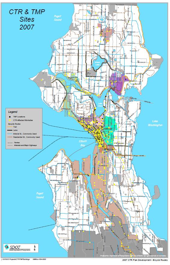
57 , 57
58 , 58

59 Exhibit #5 Map #5 Seattle s Sidewalk System with Urban Center Designations, 59

60 Exhibit #6a Local Transit Service Routes Transmittal Letter Department of Transportation Metro Transit Yesler Building, YESTR Yesler Way Seattle, WA June 19, 2007 Ms. Kathleen S. Anderson, Administrator, Commute Trip Reduction City of Seattle P.O. Box Seattle, WA RE: Basic Transit Data for CTR Planning Enclosed you will find transit data compiled by King County Metro to assist your jurisdiction in preparing your Commute Trip Reduction Plan as required under the 2006 Commute Trip Reduction (CTR) legislation. This packet includes: 1) Transit Routes (map). This map indicates all Metro and Sound Transit routes and major transit facilities located within your jurisdiction. Route numbers are indicated and the map distinguishes between peak period and all day services. 2) Active CTR Sites (map). The Active CTR Sites map locates each affected CTR site within your jurisdiction, and indicates each site s transit mode share. It also shows bus stops located near each CTR site, and indicates a onequarter mile transit access buffer along transit routes. 3) Route Frequency (map). The Route Frequency map categorizes service levels on each route as it travels to your jurisdiction The intent of this map is to help you gauge the utility of existing transit service in getting commuters to the affected worksites located in your jurisdiction. 4) Summary Route Information (Table). This table provides additional information about the transit routes serving your jurisdiction to help you assess opportunities and gaps for meeting your CTR needs. 5) Planned Transit Improvements (narrative). Two items are provided that described future transit improvements. Transit Now Ordinance describes service improvements identified for funding through revenue raised by the additional sales tax approved by voters in November Also included is Section Four of the SixYear Transit Development Plan, adopted in September 2002, which describes the overall service strategy for the King County Metro transit system. We trust this information will be useful in preparing your CTR plans in the coming months. Please call Tim Apicella at with any questions. Dave Lantry, 60
61 Supervisor King County Commute Trip Reduction Services, 61

62 Exhibit Map #6 Map of Local Transit Service Routes, 62


63 Exhibit #7 Seattle Transit Service Routes Provided by King County Metro, 63


64 Seattle Transit Service Routes Provided by King County Metro (Exhibit #7 continued), 64


65 Seattle Transit Service Routes Provided by King County Metro (Exhibit #7 continued), 65


66 Seattle Transit Service Routes Provided by King County Metro (Exhibit #7 continued), 66

67 Exhibit #8 Map # 7: COMMUNITY TRANSIT SERVICE SNOHOMISH COUNTY >SEATTLE DOWNTOWN URBAN CENTER, 67

68 Exhibit #9 MAP #8 Community Transit and Sound Transit Service, 68
69 Exhibit #10 Map #9 Percentages of Workers Commuting by Bicycle (US Census 2000), 69
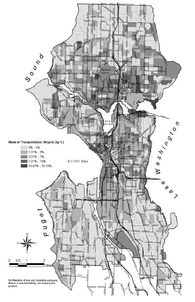
70 , 70

71 Exhibit #11 Map #10 Percentages of Workers Commuting by Foot (U.S. Census 2000), 71

72 Exhibit #12 Map #11 Sidewalk Inventory, 72

73 Exhibit #13 Map #12, Seattle s Future Transit Network, 73
74 , 74
75 Exhibit #14 Map # Major Public Works Projects, 75
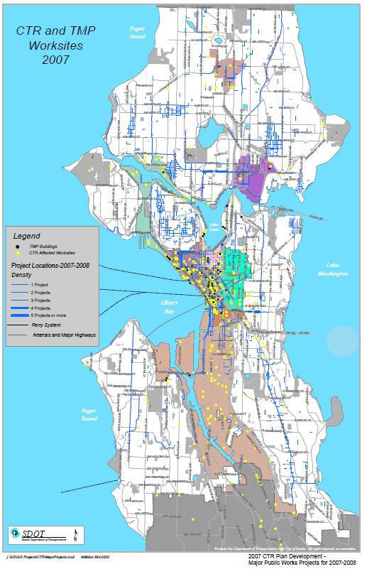
76 , 76
77 , 77
78 Exhibit #15 TRANSPORTATION MANAGEMENT PROGRAMS (TMPs) In order to meet the environmental and transportation goals of the City of Seattle as outlined in its Comprehensive Plan and related documents, Seattle Municipal Code Chapter authorizes the Department of Planning & Development (DPD) to grant, condition or deny permit applications for construction and use of public or private proposals that are subject to environmental review. When in the course of environmental review the City finds adverse traffic or parking impacts associated with either a single development or the cumulative effects of multiple projects, the City may subject a project s proponent(s) to mitigation measures by requiring the development and maintenance of a transportation management program (TMP). (See SMC Section : (B) Construction Impacts, (M) Parking, (R) Traffic and Transportation, and Section , Cumulative Effects Policy.). Map #3, Exhibit #3 on page 5, displays the TMPaffected buildings in Seattle as small black dots. TRANSPORTATION MANAGEMENT PROGRAM Project Name: Project Address Master Use Permit File No. [This program is not considered final and acceptable to the City until signed by all parties and recorded with King County Division of Records and Elections.] Part I GOALS The goals for this project shall be to achieve a percent ( %) maximum singleoccupant vehicle (SOV) commute trip rate within two years after the site s initial survey, and to achieve a percent ( %) maximum SOV commute trip rate within four years to be maintained for the life of the project. Part II TRANSPORTATION MANAGEMENT PROGRAM ELEMENTS Transportation Management Program Elements. Before the City issues a Master Use Permit or Certificate of Occupancy for this project, the applicant agrees to develop and implement an approved Transportation Management Plan (TMP) that includes the following elements unless specifically waived or designated as not applicable. 1. Building Transportation Coordinator (BTC). Before receiving a Certificate of Occupancy the applicant shall have appointed a building transportation coordinator (BTC), a permanent staff position assigned to administer the requirements of this agreement. 2. Promotion and Information. In order to ensure that employees and tenants understand TMP requirements, the applicant shall:, 78
79 a. Produce a commuter information packet (CIP), a commuter benefits brochure that contains complete information about the applicant s TMP, including transportation benefits, transportation options, HOV programs and discounts, bicycling amenities, transportation subsidies, and other elements of the TMP. b. Distribute the CIP to tenants, employees, students, other building workers and occupants and at promotional events, make copies of the CIP available in the building s Commuter Information Center. c. Redistribute the CIP and any updates to the program to tenants, employees, students, other building workers and occupants at least once each year. d. Update the CIP brochure and its contents as needed. 3. Commuter Information Center (CIC 4. Tenant Participation. The applicant shall require tenants to work with the office of the BTC for trip reduction activities and to provide information to tenants' employees. 5. Ridematch Opportunities. The applicant shall coordinate ridesharing programs among building tenants and their employees, provide ridematch services within the building or engage other ridematch facilitators to provide this service. 6. Site Improvements. The applicant shall make the following site and access improvements required by the City pursuant to the Land Use Code, Traffic Code, trip reduction laws, and similar regulations intended to mitigate traffic and environmental impacts. a. Adequate Maneuvering Space for HOVs. Height clearance and turning radii for vanpool vehicles and similar HOVs shall be sufficient to accommodate their use. b. Shower and Locker Facilities. The applicant shall provide shower and locker facilities in a location approved by the City. c. Pedestrian and Bicycle Pathways. The applicant shall provide marked and paved pedestrian and bicycle pathways that link to adjacent walkways and bikeways, lanes or trails located in the public rightofway. 7. Site Inspections. 8. Trip Reduction Networking Groups. 9. Parking Management Elements. a. Parking Fees: Fees for parking shall be at market rates but structured so that shortterm parking (e.g., parking for customers, visitors, or patients) costs less per hour than longterm parking (e.g., parking for fulltime employees). To accommodate this objective: (i) There shall be no discounted or favorable pricing for longterm parking (e.g., no early bird specials ), except for introductory rates for newlyformed carpools, registered vanpools and free parking for bicycles. (ii) The monthly parking rates shall be comparable to the monthly market rate for parking in comparably sized and located private facilities in the immediate vicinity, or shall conform to the requirements in the DPD Director s analysis and decision for the site. (iii) The rate structure shall be established so that it is more advantageous to shortterm parking; that is, it will cost less per hour than longterm SOV parking, even when such longterm parking is paid for on a monthly or annual basis. (iv) Registered vanpools may park free of charge. b. Unbundling Parking in Building Space Leases: The applicant shall not bundle the price of parking spaces into the price of building space but shall set the price for parking spaces at market value and sell them separately from the sale of building space. c. Parking Operations: Preferential parking locations for HOV and shortterm parking. d. Bicycle Parking. Provide free, covered, secure parking for bicycles Promote and Encourage Alternative Work Schedules. 11. Carsharing vehicle or program. 12. Promote and Encourage Telecommuting. 13. Guaranteed Ride Home Program. 14. Onsite Transit Pass Sales. 17. Annual Reporting., 79
80 , 80
81 Exhibit #16 Street Design Standards Seattle is very progressive in its design standards. While the City s standards currently meet or exceed State requirements, the City may modify these standards and policies in the future within the context of its Complete Streets Initiative. This will make Seattle streets even more accessible for all users and increase the transportation choices available. The Bicycle and Pedestrian Master Plans outline in detail the changes that Seattle will incorporate into the standards for work performed in the public rightofway. Travel Lanes Seattle streets are classified as arterials or nonarterials (neighborhood streets). The nonarterials are generally lower volume roadways with pavement widths varying between 20 and 40. Centerline striping is not provided on nonarterials and bicycles most commonly share the travel way with motor vehicles. Design Criteria: ROWIM3: Through traffic lane 11 feet Curb lane 12 feet Bus only lane 12 feet Wide outside lane (vehicle/bicycle) 14 feet Wash DOT: 11 feet min; varies based upon speed and road classification AASHTO: 10 feet minimum; 1112 feet preferred in urban areas4 Design Considerations: AASHTO provides flexibility in the establishment of lane width by discussing the merits of reduced lane width for interruptedflow operating conditions and constrained conditions. AASHTO also states that local practice and experience regarding lane widths should also be evaluated.5 The consideration of narrow travel lanes should also take into account truck and bus volumes. Bicycle Lanes Design Criteria: Curb or adjacent to parking: ROWIM 5 feet, min. WSDOT 5 feet, min. AASHTO 5 feet, min. No curb or parking: ROWIM 4 feet, min. WSDOT 4 feet, min. AASHTO 4 feet, min. Design Considerations: The minimum width for a bicycle lane adjacent to parking lane is 5. A bicycle lane adjacent to the edge of the road without a curb may be 4 in width. Bicycle lane stripes are recommended to be 6inchwide solid white line. In locations with onstreet parking, two stripes should be used to define a bicycle lane: one stripe on the travellane side, and one stripe on the parkinglane side of the bicycle lane. These stripes should be dashed in areas where motorists can be expected to merge across the bicycle lane. The design of bicycle lanes wider than 6 should be carefully considered as they can appear to be vehicular travel lanes to motorists. A buffered bicycle lane can encourage bicyclists to ride away from the opening doors of parked vehicles by adding pavement markings to the bike lane. This treatment could be particularly useful to delineate the dooring area where: Bicycle lanes are adjacent to 7 or 8foot parking Bicycle lanes adjacent to high turnover parking Locations of dooring complaints Buffered bicycle lanes also may be considered on steep roadways where higher bicycle speeds can be expected and where more severe dooring crashes can be expected. Buffered bicycle lanes may be accompanied by signs reminding drivers to look for bikes when opening their doors. Shared Travel Lanes, 81
82 Shared travel lanes are distinctive from travel lanes because they include shared lane markings (SLM) within the travel lane. Shared lane markings are typically applied in constrained locations where bicycle lanes are not feasible. Design Criteria: Shared travel lanes follow the same design criteria as travel lanes. A shared travel lane shall be marked by a shared lane marking (from the ROWIM, figure 418). If adjacent parking is present, the marking shall be located 12 from the curb for a 10 to 12 travel lane, and 11 from the curb for a travel lane 13 or greater. In locations where the travel lane is adjacent to curb or roadway edge, the center of the marking is placed 4 from the curb or edge. Design Considerations: It is desirable to have a shared travel lane be a wide outside lane of 12 to 14. Shared travel lanes should be considered for the following situations: On constrained roadways that are too narrow to stripe bicycle lanes To delineate space within a wide outside lane where bicyclist can be expected to ride On multilane roadways where bicyclists can be expected to travel within the outside lane and motorists should be prepared to change lanes to pass bicyclists On roadways where it is important to increase motorist awareness of bicyclists On roadways where bicyclists frequently ride the wrong way On roadways where bicyclists tend to ride too close to parked cars Center Turn Lanes Center turn lanes can be utilized to remove turning vehicles from the through travel lanes. This can improve roadway capacity and potentially allow for fewer through travel lanes. Design Criteria: AASHTO 1016 feet7 Design Considerations: The width of the center turn lane should be based upon traffic volume. Careful consideration should also be given to the determination of whether a continuous center turn lane is more advantageous than a dedicated left turn lane. For roadways with lower volume turning movements it may be more beneficial to provide medians or crossing islands and dedicated left turn pockets. AASHTO recommends the use of an 11 width for continuous twoway left turn lanes. Dedicated Turn Lanes Similar to center turn lanes, dedicated turn lanes can be utilized to remove turning vehicles from the through travel lanes to improve roadway capacity and potentially allow for fewer through travel lanes. Design Criteria: ROWIM: 12 feet Wash DOT: 11 feet min; varies based upon speed and road classification AASHTO 9 feet min. (arterial design speed less than 40 mph) Design Considerations: The width of the turn lane should be based upon traffic volume and speed. Careful consideration should also be given to the determination of the length of the turn lane as it is often necessary to drop bicycle lanes or narrow travel lanes to install a dedicated turn lane. Bicycle lanes should be dropped up to 100 prior to dedicated turn lanes or if bicycle lanes are present, they shall be located to the left of right turn lanes and to the right of left turn lanes. Parking Areas Design Criteria: ROWIM: 8 feet9 minimum 10 feet on a bus route WSDOT: 8 feet AASHTO: 7 feet minimum (nonarterial streets primarily accommodating passenger vehicles) 8 feet minimum (arterial) 1012 feet10 (for use as possible through lane) Design Considerations: The use of 7 parking adjacent to bicycle lanes or wide outside lanes in lieu of the 8 minimum may be an option where space is constrained. The addition of a bicycle lane or a wider outside lane alleviates the primary AASHTO concern of sideswiping. Research11 has, 82
83 found that parked vehicles can be held closer to the curb or edge of the roadway with the use of a 7 striped parking line. If bus bulbs are installed in the parking area for inlane bus stops on express routes, they would be infrequent. Bicycle lanes can still be provided on these streets, but would be discontinuous at the express bus stop. Appropriate warning signage and markings would be provided for bicyclists and motor vehicle operators at these locations. Some streets in Seattle have a soft surface area located adjacent to the roadway that allows parking. Soft surface areas where parking is allowed that are narrower than 7 should be widened or parking should be restricted to improve safety along a roadway. If parking is allowed, an edgeline should be installed to encourage motorists to park off from the roadway. The roadway edgeline stripe is recommended to be 4inchwide solid white line. The designer should consider the following options in locations where parked vehicles continue to encroach on the travel way: increase the edgeline (parking line) width to 6inches provide parking regulation signs notifying drivers to park off the traveled way reconstruct the shoulder with curb and gutter to define parking area Shoulders Soft surface shoulders are located adjacent to a number of roadways in Seattle. Soft shoulder areas provide an opportunity for improvements to the roadway cross section, but can create suboptimal conditions for bicyclists in certain situations. Design Criteria: ROWIM: 5 feet (non arterial12) WSDOT: 8 feet (parking allowed) AASHTO: varies Design Considerations: Shoulders that have a poorlymaintained pavement edge are not desirable for bicyclists operating close to the edge of the roadway (a common practice for bicyclists riding on roadways with narrow travel lanes). Elimination or reduction of the shoulder may be considered under the following circumstances: To provide space for an enhanced bicycle facility (wider travel lane or bicycle lane) In locations where there is excess parking capacity In locations where the shoulder is greater than 7 in width If a shoulder is designated as a bicycle lane, it must be at least 4 wide. Factors to be considered when Selecting Bicycle Facilities Many of the factors previously mentioned (e.g., capacity, traffic volume and speed, onstreet parking turnover, heavy truck volumes, etc.) are taken into consideration when determining an optimal cross section for a retrofit project. The relationship between these factors and cross section elements is a key step in the analysis process to determine an optimal cross section. Capacity, speed, volume, heavy vehicles, grades, and parking directly relate to the need for, and dimension of cross section elements. These factors are further discussed below to provide guidance to the designer to achieve increased modal balance within the constrained cross section, and provide the best possible bicycle facility. Roadway Capacity Roadway capacity is considered when examining the number and type of vehicular travel lanes. If a reduction in the number of travel lanes is desired, a traffic analysis should be performed to determine if that option is feasible. Traffic Volume and Speed Roadways with higher vehicular speed and volumes are less comfortable for cyclists, and are therefore in more need of dedicated bicycle facilities. Excess capacity can also result in higher traffic speeds. Some roads may benefit from the fewer travel lanes or conversion of travel lanes to turning lanes. Reducing traffic volume and/or speed can also allow for the installation of narrower travel lanes and turn lanes. Heavy Vehicles Heavy vehicles (trucks and buses) may require additional operating space on roadways. Additionally, frequent passing of bicyclists by heavy vehicles in a narrow cross section may create conflicts. The AASHTO Guide cites if substantial truck traffic is anticipated, additional lane width may be desirable. 13 The use of travel lanes below 11 is not recommended on streets with a high, 83
84 percentage of heavy vehicles. This guidance recommends a threshold of 10% of the ADT or greater. Road Grade Road grade has the largest affect on bicyclist operating speed. On steep ascents, bicyclists may be slowed to the speeds of pedestrians. On steep descents, bicyclists may exceed motor vehicle speeds. On constrained rightsofway the designer can accommodate a bicyclist in a narrower cross section by utilizing a climbing bicycle lane in the uphill side of the road. On downhill sections that bicyclist can be directed to share the lane with motorist. This can reduce the total width required for the roadway cross section. Careful consideration should be given to placing bicycle lanes adjacent to parking on portions of roadways with steep descents (See Bicycle Lane discussion). OnStreet Parking Demand Providing ample onstreet parking is often considered an important need by the general public, and efforts to reduce or eliminate it can be met with strong opposition. However, the reduction or elimination of parking should be considered in areas where bicyclists are constrained to riding too close to parked vehicles or where enhanced bicycle facilities are desirable. In locations where there is excess parking capacity, consideration should be given to the following options: consolidate parking to one side of road remove parking completely where there is no demand or sufficient off street capacity remove parking temporarily where there is a need for additional throughput capacity (i.e. peak hour bike lane, bus lane, and/or travel lane) OnStreet Parking Turnover High parking turnover can affect the safety of all roadway users. The bicyclist is typically the most vulnerable roadway user because they often ride adjacent to parked vehicles. When riding within the area of an opening door, the bicyclists is in danger of being struck and injured. Existing law14 requires a motorist to not open a door into moving traffic; nonetheless, the designer should consider this potential hazard in the design process. To reduce the impact of dooring the designer may consider reducing or eliminating parking, providing a buffered bicycle lane or adding dooring warning signs (See Bicycle Lane discussion). Bicycle Facility Continuity Considerations at Intersections Continuity of bicycle facilities at intersections takes into consideration the cross section elements and design factors mentioned above. Intersection treatments may vary depending on the approaching cross section. Conversely, bicycle treatments at closely spaced intersections may determine the cross section between nodes. Under ideal circumstances a standard bicycle lane would be accommodated at the approach to an intersection. However, with the frequent need for dedicated turn lanes at intersections, the roadway cross section can become constrained. The following designs offer options for accommodating bicycles in these constrained locations. Pocket Lane Pocket lanes are used when there isn t sufficient space to install a bicycle lane at the approach to an intersection. Pocket lanes provide for a continuous bicycle facility through an intersection. They can encourage motorists to drive more slowly, and maintain a consistent traveling path. The striped pocket lane encourages throughmoving bicyclists to stay to the left of right turning vehicles, and the lane enables bicyclists to bypass stopped vehicles. Pocket lanes should be a minimum of 3 in width and should not be marked as bicycle lanes (e.g., should not include the bicycle symbol pavement marking). Pocket lanes are not recommended on roadways with high speeds or high heavy vehicle volumes (10% of ADT or greater). This policy is considered experimental and it is recommended that Seattle conduct additional experimental studies before widespread implementation., 84
85 Exhibit #17 Public Outreach Exhibits 17A 17E A. Exhibit 17A: In May, 2007, the City sent the following questionnaire to the property managers of TMPaffected buildings located in the Downtown Urban Center who are most likely to be affected by and involved with the GTEC Program. TMP Building Manager Survey Questions May 23, 2007 Using the following scale, please respond to the following four questions. 1 = not at all concerned or interested 2 = somewhat concerned, but not interested enough to be engaged in solving the problem 3= major concerns, but not sure what to do or how to do it. 1. How much do you think traffic congestion concerns you and your tenants? 2. How concerned are you and your tenants about the impacts of traffic congestion five years from now? 3. Are you and your tenants concerned about the effect that major construction projects (like the rebuilding of the viaduct, the replacement of the Evergreen Point Bridge, and major construction downtown) will have on the ability of tenants and customers to access the building? 4. Have you thought what your company do to promote alternative commute options among building tenants? Please provide answers to the following questions. 1. What significant barriers do you believe your tenants face when choosing or attempting to use an alternative mode of transportation to commute to work? 2. What transit improvements do you think would reduce the number of drive alone commute trips to your site? 3. What pedestrian/bicycle facility improvements, if any, could help lessen the number of drive alone commute trips to your site? 4. What can the City of Seattle do to support your building s TMP? 5. Would you be interested in reviewing/commenting on the City s draft CTR Plan Update? B. Exhibit 17B: In May, 2007, the City sent the following questionnaire to its 254 CTRaffected Employers as a follow up to discussions of TDM barriers and related issues at quarterly CTR Employer Network Group Meetings held between August 2006 and December Questions for CEOs at all CTR Sites 1. On a scale of 1 to 5 (1 = No knowledge to 5 = Total Understanding), rate your awareness of what the CTR law requires your company to do. 2. How can we help you/your employees better understand the CTR law and regulations? 3. How does traffic congestion impact your employees and company s productivity? 4. On a scale of 1 to 5 (1 = No concern to 5 = Concerned enough to consider moving the work site), how concerned are you about the impact of traffic congestion five years from now? 5. What would motivate your employees to reduce the number of drive alone trips to work? 6. What could your organization do, that it is not already doing, to promote alternative commute options? 7. What can the City of Bellevue do to support your company s CTR program? 8. Would you be interested in reviewing/commenting on the City s draft CTR Plan Update? Questions for ETCs and Program Managers 10. What significant barriers do your employees face when choosing or attempting to use an alternative mode of transportation to commute to work? 11. What transit improvements, if any, could help lessen the number of drive alone commute trips to your site? 12. What pedestrian/bicycle facility improvements, if any, could help lessen the number of drive alone commute trips to your site? 13. What resources or support would make it easier for you to promote van/carpool options to your employees? 14. What would motivate your employees to reduce the number of drive alone trips to work? 15. What can your company do, that it is not already doing, to promote alternative commute options? 16. What can the City of Seattle do to support your company s CTR program?, 85
86 17. Would you be interested in reviewing/commenting on the City s draft CTR Plan Update?, 86
87 C. Exhibit 17C. In August 2007, the City will send the following notice: FOR IMMEDIATE RELEASE: FOR MORE INFORMATION CONTACT: Gregg Hirakawa (206) Changes in Commute Trip Reduction Law (Seattle) The 2006 Washington Legislature adopted the Commute Trip Reduction (CTR) Efficiency Act to revise the existing CTR law. For most major employers, the new law will not change their basic CTR requirements. The new law focuses CTR effort and resources on the most densely populated and congested urban areas and highway corridors, rather than on entire counties. The Act also attempts to foster planning coordination among local jurisdictions, regional transportation planning organizations, and the state. The city believes it can meet its trip reduction goals through continued implementation of CTR strategies and as commuters take increasing advantage of public investments in multimodal transportation infrastructure and services. The new law will enable jurisdictions to develop Growth and Transportation Efficiency Center (GTEC) programs to accomplish CTR goals. GTEC resources will be used to offer CTR incentives, products and services at densely populated buildings and developments. This would enable the extension of the CTR program to small organizations or businesses grouped together in large buildings, which previously may not have had access to CTR resources. CTRaffected employers occupying large buildings may also take advantage of buildingwide CTR promotion programs, thereby lowering an individual business s CTR marketing costs. SDOT will accept comments and suggestions or answer questions about its proposed CTR plan and GTEC program through June 15, Following this initial review period, SDOT will make appropriate amendments to its plans and submit final drafts to the Puget Sound Regional Council for review on July 2, For more information on the CTR program, call or (kathy.anderson@seattle.gov). A summary of the proposed GTEC Program will be available at or by contacting a King County Metro CTR Employer Representative at The Seattle Department of Transportation builds, maintains and operates Seattle's $8 billion transportation infrastructure. To further Mayor Nickels goal to get Seattle moving, the department manages short and longterm investments in streets, bridges, pavement and trees, that better connect the city with the region., 87
88 D. Exhibit 17 D is the Preliminary Draft GTEC Program Summary that the City posted on its Web Site: Introduction Preliminary Draft GTEC PROGRAM SUMMARY PROPOSAL City of Seattle In 2006 the Washington State Legislature and Department of Transportation (WSDOT) adopted a new concept, The Growth and Transportation Efficiency Center (GTEC) as part of the CTR Efficiency Act. The state's goal is to provide greater access to employment and residential centers while increasing the proportion of people not driving alone during peak periods on the state highway system. Cities like Seattle may designate one or more GTECs in order to establish CTR or transportation demand management (TDM) programs in the designated Center. The City of Seattle has decided to try this option and, consistent with state guidelines, consult with appropriate stakeholders about its development and implementation. A summary of the GTEC program for Seattle follows, and the City invites your review and comments to: kathy.anderson@seattle.gov Growth and Transportation Efficiency Center Program Proposal: Seattle s GTEC Program supports the vision of an economically vibrant community with increasing commercial and residential density, and improved mobility and air quality. The program also supports the City s integration of land use and transportation planning, and improvements in transportation service and infrastructure that meet the needs of commuters and the business community. Consistent with state guidelines, the City s GTEC Program would: A. Designate the boundaries of the GTEC and a target population; B. Develop a TDM program that is consistent with RCW and WAC C. Establish goals for reducing the proportion of singleoccupant vehicle trips that are more aggressive than the state program goal; D. Provide a sustainable financial plan that includes resources from public and private sources that are available to carry out the plan to finance needed facilities, services, and programs; and E. Propose an organizational structure for implementing the program; A. The GTEC boundary and target population for Seattle s GTEC Program is small employers who are located in densely populated (highrise) developments and buildings in the Downtown Urban Center. The City of Seattle has partnered with King County Metro and the Downtown Seattle Association to bring incentive products, programs and services to employers who have not had opportunities to learn about or access to the services and incentives that are available provided through the CTR Law or Transportation Management Programs. B. The GTEC (TDM) Program. The City of Seattle and its partners propose to reach out to managers of densely populated buildings and offer them a menu of products and services that would benefit their tenants and employees and facilitate access to their worksites at a time that coincides with the delivery of new transportation facilities and services. These would include: e. Orientation and introductions to TDM productions and services Education Marketing strategies Goals and targets Measuring Achievement f. Services that will be offered to most buildings and tenants: Training in the development and promotion of employer transportation programs., 88
89 Training in head tax deductions for HOV users; presentations to building managers for tenants Training in the development of PreTax incentives. Training in how to take the HOV deduction from the Employee Hours (Head) Tax Employer networking opportunities Coordination of transportation services among employers and worksites Transportation events Onsite Plan Your Commute trip planning sessions Rideshare on line.com promotions with emphasis on car and vanpool formation g. Products that will be available to most buildings and tenants:: Fully developed transportation web pages with links to KCMCTST transit routes and schedules, WSF ferry service timetables, calculate the cost of your commute, ridematch on line, WSDOT Traffic Cams, real time traffic reports, area traffic alerts and delay information, bike routes and locations of facilities, vanpool formation services, portals to other transportation services and information. Templates for producing customized transportation information and materials to employees Home Free Guarantee Subscription Program, whereby unaffected employees who commute using HOV or nonmotorized modes have access to prepaid taxi service in case of an emergency. Buildingwide trip reduction challenges, report building wide results, provide buildingwide and/or individual incentives h. Incentives: Smart cards for vanpool and transit service. Deductions from the City s Employee Tax. Valuable TDM services and products at little or no cost to recipients. i. Expand the Circle: Extend outreach and TDM products and services to property managers, tenants and other populations in the City s urban centers that fit the state s criteria for eligibility and enable them to meet goals for trip reduction and vehicle miles traveled. C. SOV & VMT Targets by Urban Center Area of Jurisdiction 2005 SOV Rate* 2011 SOV Target 2005 VMT* 2011Target VMT Downtown Urban 27% 24% 4.79 miles 4.16 miles Center Capital HillFirst Hill 42% 37% 7.07 miles 6.15 miles UC Duwamish MIC 62% 55% miles miles InterbayBallard MIC 60% 54% 9.25 miles 8.05 miles Northgate UC 72% 65% miles 9.60 miles South Lake Union UC 59% 53% 8.75 miles 7.62 miles University Community 46% 42% 7.55 miles 6.57 miles UC Uptown UC 58% 52% 9.06 miles 7.88 miles All Centers Overall 53% 48% 8.65 miles 7.52 miles Outlying Sites 44% 40% 7.36 miles 6.40 miles Seattle Overall 49% 44% 8.02 miles 6.98 miles *SOV = Single occupant vehicle; VMT = Vehicle miles traveled, 89
90 D. Two Year Sustainable Financial Plan Direct Support Amount of Support Period of Support State of Washington GTEC Funds $300, Downtown Transportation Alliance $300, InKind and Indirect Support Downtown Carpool Parking Program $ 300, One Less Car Incentive 26, In Motion Incentive 70, Transportation capital investments in TDM $220,000, E. Organizational structure for implementing the program The City of Seattle will administer the GTEC Program and be responsible for its overall management through the Traffic Division of the Seattle Department of Transportation (SDOT). The Urban Mobility Group of the Downtown Transportation Alliance will perform initial contact and outreach to participating building managers by way of a contract for the performance of this work. King County Metro CTR Services Staff will provide direct support, programs and incentives to participants, reporting directly to SDOT by way of an interagency agreement for the performance of this work. F. Review Period: The City will accept comments and recommendations through June 15, To request the complete text of the City of Seattle s DRAFT GTEC Program, please contact Kathleen Anderson at or kathy.anderson@seattle.gov G. Calendar of Milestones January 1 June 30, 2007 Informal review and comment period for preliminary draft June 1 June 30 Prepare Preliminary Draft GTEC Program July 2, 2007 Submit Preliminary Draft to PSRC July 2 August 31, 2007 PSRC Review and Comment Period August 31 September 30, 2007 Prepare Final Draft October 1, 2007 Submit PSRCApproved Plan to State CTR Board October 1 December 30, 2007 State CTR Board Review Period January March 2008 Adopt CTR Ordinance, Revising SMC March 1 December 31, 2008 Implement CTR Plan and GTEC Program E. H. Exhibit 17 E ISSUE PAPER #6: Mode Split Targets for Urban Centers Seattle s Comprehensive Plan includes a set of mode split goals in its Transportation Element. These goals aim to increase the use of alternatives to the single occupancy vehicle by Seattle residents. Inclusion of mode split goals satisfies Countywide Growth Management Policies that local jurisdictions establish mode split goals for employment Centers. Nevertheless, there are problems with the mode split goals as currently established by the Comprehensive Plan. Specifically: The city did not meet its 2000 mode split goals. The current citywide mode split goals tell us little about mode split in urban centers and villages where future growth and transportation alternatives are concentrated. This means that their usefulness in targeting transportation investments and in managing transportation services for growth is limited. The mode split goals do not provide information on how Seattle s transportation system is used by commuters who work in Seattle but live outside the city., 90
91 The Comprehensive Plan Update provides an opportunity to evaluate not just our progress toward reaching mode split goals, but to consider how mode split goals can be used most effectively in making investment in transportation services and facilities over the life of the Comprehensive Plan. Below is a discussion providing background, considerations for revision, and a recommended approach to setting mode split goals. Background Mode split refers to the choices people make between available transportation modes. Seattle s transportation system consists of singleoccupant vehicles, car pools, and public transportation, use of bicycles or walking, and working at home. Each of these methods of travel is a.mode.. Through the urban village strategy, Comprehensive Plan policies encourage development of land use patterns and transportation systems that reduce use of singleoccupant vehicles. The mode split goals in the comprehensive Plan quantify reducing the number of people who travel to work using single occupancy vehicles and instead use alternative transportation modes. The U.S. Census Data for the year 2000 shows that, in spite of making progress, Seattle fell short of its citywide mode split goals. Seattle s Comprehensive Plan Update Issue Paper #6: Mode Split Targets for Urban Centers table below shows both the Comprehensive Plan mode split goals for 2000 and 2010 and the actual mode split for the years 1990 and MODE CHOICE ACTUAL 2000 GOAL 2010 GOAL ACTUAL Single Occupant Vehicle 59% 56% 51% 35% (SOV) Non SOV Modes Carpool 12% 11% 12% 13% Public Transportation 16% 18% 20% 27% Bicycle and other 3% 3% 5% 9% Walk 7% 7% 8% 10% Work at Home 3% 5% 4% 6% Total 100% 100% 100% 100%, 91

92 Exhibit #18: Map #14, Seattle s GTEC Boundary: The Downtown Urban Center, 92
Bicycle Master Plan Goals, Strategies, and Policies
 Bicycle Master Plan Goals, Strategies, and Policies Mobilizing 5 This chapter outlines the overarching goals, action statements, and action items Long Beach will take in order to achieve its vision of
Proposed. City of Grand Junction Complete Streets Policy. Exhibit 10
 Proposed City of Grand Junction Complete Streets Policy Exhibit 10 1 City of Grand Junction Complete Streets Policy Vision: The Complete Streets Vision is to develop a safe, efficient, and reliable travel
Chapter 2. Bellingham Bicycle Master Plan Chapter 2: Policies and Actions
 Chapter 2 Bellingham Bicycle Master Plan Chapter 2: Policies and Actions Chapter 2: Policies and Actions The Bicycle Master Plan provides a road map for making bicycling in Bellingham a viable transportation
Chapter 7. Transportation. Transportation Road Network Plan Transit Cyclists Pedestrians Multi-Use and Equestrian Trails
 Chapter 7 Transportation Transportation Road Network Plan Transit Cyclists Pedestrians Multi-Use and Equestrian Trails 7.1 TRANSPORTATION BACKGROUND The District of Maple Ridge faces a number of unique
ACTIVE TRANSPORTATION
 ACTIVE TRANSPORTATION Mobility 2040 Supported Goals Improve the availability of transportation options for people and goods. Support travel efficiency measures and system enhancements targeted at congestion
Exhibit 1 PLANNING COMMISSION AGENDA ITEM
 Exhibit 1 PLANNING COMMISSION AGENDA ITEM Project Name: Grand Junction Circulation Plan Grand Junction Complete Streets Policy Applicant: City of Grand Junction Representative: David Thornton Address:
C C C
 C-012-001 Thank you for your support for the creation of new public space and nonmotorized access between downtown and the waterfront through the Overlook Walk, the East-West Connections, and the Promenade.
Solana Beach Comprehensive Active Transportation Strategy (CATS)
") Solana Beach Comprehensive Active Transportation Strategy (CATS) 3.0 Goals & Policies The Solana Beach CATS goals and objectives outlined below were largely drawn from the Solana Beach Circulation Element
Solana Beach Comprehensive Active Transportation Strategy (CATS) 3.0 Goals & Policies The Solana Beach CATS goals and objectives outlined below were largely drawn from the Solana Beach Circulation Element
Transportation Master Plan Advisory Task Force
 Transportation Master Plan Advisory Task Force Network Alternatives & Phasing Strategy February 2016 BACKGROUND Table of Contents BACKGROUND Purpose & Introduction 2 Linking the TMP to Key Council Approved
Living Streets Policy
 Living Streets Policy Introduction Living streets balance the needs of motorists, bicyclists, pedestrians and transit riders in ways that promote safety and convenience, enhance community identity, create
Circulation in Elk Grove includes: Motor vehicles, including cars and trucks
 Circulation, as it is used in this General Plan, refers to the many ways people and goods move from place to place in Elk Grove and the region. Circulation in Elk Grove includes: Motor vehicles, including
Agenda. Overview PRINCE GEORGE S PLAZA METRO AREA PEDESTRIAN PLAN
 PRINCE GEORGE S PLAZA METRO AREA PEDESTRIAN PLAN May 28, 2008 Agenda Welcome and introductions Project overview and issue identification Planning context and strengths Design challenges and initial recommendations
Perryville TOD and Greenway Plan
 Perryville TOD and Greenway Plan Greenway Glossary Pathway: A bicycle and pedestrian path separated from motorized vehicular traffic by an open space, barrier or curb. Multi-use paths may be within the
5. Pedestrian System. Accomplishments Over the Past Five Years
 5. Pedestrian System Accomplishments Over the Past Five Years The Alamo Area Metropolitan Planning Organization (MPO) and its partner agencies recognize the importance of improving pedestrian mobility.
CITY OF COCOA BEACH 2025 COMPREHENSIVE PLAN. Section VIII Mobility Element Goals, Objectives, and Policies
 CITY OF COCOA BEACH 2025 COMPREHENSIVE PLAN Section VIII Mobility Element Goals, Objectives, and Policies Adopted August 6, 2015 by Ordinance No. 1591 VIII MOBILITY ELEMENT Table of Contents Page Number
CONNECTING PEOPLE TO PLACES
 CONNECTING PEOPLE TO PLACES 82 EAST BENCH MASTER PLAN 07 Introduction The East Bench transportation system is a collection of slow moving, treelined residential streets and major arteries that are the
CITY OF BLOOMINGTON COMPLETE STREETS POLICY
 CITY OF BLOOMINGTON COMPLETE STREETS POLICY POLICY OBJECTIVE: The City of Bloomington will enhance safety, mobility, accessibility and convenience for transportation network users of all ages and abilities,
University of Victoria Campus Cycling Plan Terms of Reference. 1.0 Project Description
 University of Victoria Campus Cycling Plan Terms of Reference 1.0 Project Description The Campus Cycling Plan, a first for the University, will provide a comprehensive and coordinated approach to support
Corpus Christi Metropolitan Transportation Plan Fiscal Year Introduction:
 Introduction: The Safe, Accountable, Flexible, Efficient Transportation Equity Act: A Legacy for Users (SAFETEA-LU) has continued the efforts started through the Intermodal Surface Transportation Efficiency
APPENDIX A: Complete Streets Checklist DRAFT NOVEMBER 2016
 APPENDIX A: Complete Streets Checklist DRAFT NOVEMBER 2016 Complete Streets Checklist MetroPlan Orlando s Complete Streets Checklist is an internal planning tool for staff to further implementation of
ACTIVE TRANSPORTATION/NONMOTORIZED TRANSPORTATION
 ACTIVE TRANSPORTATION/NONMOTORIZED TRANSPORTATION BACKGROUND Active transportation, also known as nonmotorized transportation, is increasingly recognized as an important consideration when planning and
PEDESTRIAN ACTION PLAN
 ATTACHMENT 2 CITY OF SANTA MONICA PEDESTRIAN ACTION PLAN CITY OF SANTA MONICA PEDESTRIAN ACTION PLAN This page intentionally left blank EXECUTIVE SUMMARY CHAPTER 1 EXECUTIVE SUMMARY Setting the Stage
City of Novi Non-Motorized Master Plan 2011 Executive Summary
 City of Novi Non-Motorized Master Plan 2011 Executive Summary Prepared by: February 28, 2011 Why Plan? Encouraging healthy, active lifestyles through pathway and sidewalk connectivity has been a focus
RESOLUTION NO ?? A RESOLUTION OF THE CITY OF NEPTUNE BEACH ADOPTING A COMPLETE STREETS POLICY
 RESOLUTION NO. 2018-?? A RESOLUTION OF THE CITY OF NEPTUNE BEACH ADOPTING A COMPLETE STREETS POLICY WHEREAS, safe, convenient, and accessible transportation for all users is a priority of the City of Neptune
Purpose and Need. Chapter Introduction. 2.2 Project Purpose and Need Project Purpose Project Need
 Chapter 2 Purpose and Need 2.1 Introduction The El Camino Real Bus Rapid Transit (BRT) Project (Project) would make transit and other transportation improvements along a 17.6-mile segment of the El Camino
Chapter 9: Pedestrians and Bicyclists
 Chapter 9: Pedestrians and Bicyclists Walking and bicycling are essential modes of transportation. These modes allow people to travel without contributing to congestion and air pollution, to access other
SANTA CLARA COUNTYWIDE BICYCLE PLAN August 2008
 SANTA CLARA COUNTYWIDE BICYCLE PLAN August 2008 To assist VTA and Member Agencies in the planning, development and programming of bicycle improvements in Santa Clara County. Vision Statement To establish,
How To Encourage More Efficient Transportation in Brazilian Cities
 How To Encourage More Efficient Transportation in Brazilian Cities Todd Litman Victoria Transport Policy Institute Presented Seminar on Discouraging The Use Of Cars São Paulo, Brazil 3 September 2013 Creating
Existing Transportation System
 < Open for Additional Text Transportation System Existing Transportation System This section describes vehicular transportation associated with Children s. transportation are described in a separate section
Develop a Multi-Modal Transportation Strategy (Theme 6)
") DEVELOP A MULTI-MODAL TRANSPORTATION STRATEGY (THEME 6) WHY IS THIS THEME ADDRESSED? Develop a Multi-Modal Transportation Strategy (Theme 6) Statement of Ideal Reduce resident and visitor reliance on single
DEVELOP A MULTI-MODAL TRANSPORTATION STRATEGY (THEME 6) WHY IS THIS THEME ADDRESSED? Develop a Multi-Modal Transportation Strategy (Theme 6) Statement of Ideal Reduce resident and visitor reliance on single
21.07 TRANSPORT CONNECTIVITY AND INFRASTRUCTURE
 21.07 TRANSPORT CONNECTIVITY AND INFRASTRUCTURE 21.07-1 Connectivity and Choice Transport connectivity and mode choice are critical to achieving productive, sustainable and socially just cities. Travel
REGIONAL BICYCLE AND PEDESTRIAN DESIGN GUIDELINES
 REGIONAL BICYCLE AND PEDESTRIAN DESIGN GUIDELINES November 16, 2011 Deb Humphreys North Central Texas Council of Governments Bicycle and Pedestrian Advisory Committee Snapshot of the Guide 1. Introduction
PRINCE GEORGE S PLAZA METRO AREA PEDESTRIAN PLAN
 PRINCE GEORGE S PLAZA METRO AREA PEDESTRIAN PLAN May 28, 2008 Agenda Welcome and introductions Project overview and issue identification Planning context and strengths Design challenges and initial recommendations
Non-Motorized Transportation 7-1
 Non-Motorized Transportation 7-1 Transportation facilities no longer mean just accommodating a vehicle powered by a combustion engine. Pedestrian and non-motorized facilities are important modes of travel
MCTC 2018 RTP SCS and Madera County RIFP Multi-Modal Project Eval Criteria GV13.xlsx
 MCTC 8 RTP SCS and Madera County RIFP Multi-Modal Project Eval Criteria GV.xlsx Madera County Transportation Commission Regional Transportation Plan / Sustainable Communities Strategy Multi-Modal Project
Basalt Creek Transportation Refinement Plan Recommendations
 Basalt Creek Transportation Refinement Plan Recommendations Introduction The Basalt Creek transportation planning effort analyzed future transportation conditions and evaluated alternative strategies for
DRAFT MOVING FORWARD RHODE ISLAND BICYCLE MOBILITY PLAN 2018 PREPARED FOR PREPARED BY IN ASSOCIATION WITH
 RHODE ISLAND MOVING FORWARD BICYCLE MOBILITY PLAN 2018 PREPARED FOR PREPARED BY IN ASSOCIATION WITH T AF CHAPTER 1 D R INTRODUCTION CHAPTER 3 ARTICULATES VISION Bicycling is safe, fun and practical in
Interim Transit Ridership Forecast Results Technical Memorandum
 Interim Transit Ridership 401 South Jackson Street Seattle, WA 98104-2826 September 2012 Table of Contents 1 INTRODUCTION... 1-1 1.1 Project Background... 1-1 2 RIDERSHIP FORECASTS... 2-1 2.1 System Ridership
BIKE PLAN CONTENTS GATEWAY
 CONTENTS Acknowledgments...vii Great Rivers Greenway District Board of Directors... vii Great Rivers Greenway District Staff... vii Project Consultants... vii Committees... viii Citizens Advisory Committee
Existing Transportation System
 < Please Open Page for Additional Text Transportation System Existing Transportation System This section describes vehicular transportation associated with Children s. Pedestrian and other nonmotorized
Governor s Transportation Vision Panel
 Office of Governor Kate Brown Governor s Transportation Vision Panel JLA Public Involvement Project Overview The is a yearlong effort to develop a series of recommendations for the Governor that address
May 12, 2016 Metro Potential Ballot Measure Issue Brief: Local Return
 Summary: Local return is an important revenue source for cities to maintain their local transportation infrastructure. Most cities use their local return to operate small bus systems and repave streets,
12 RECOMMENDATIONS Road Improvements. Short Term (generally the next five years)
") 12 RECOMMENDATIONS Recommendations are based on the technical analysis of existing and future road and active transportation conditions, the results of the review of existing City policies and public feedback.
12 RECOMMENDATIONS Recommendations are based on the technical analysis of existing and future road and active transportation conditions, the results of the review of existing City policies and public feedback.
CPC Parking Lot Riverside Drive. Transportation Rationale
 CPC Parking Lot Transportation Rationale Prepared By: NOVATECH Suite 200, 240 Michael Cowpland Drive Ottawa, Ontario K2M 1P6 September 2015 Novatech File: 114093 Ref: R-2015-153 Table of Contents 1.0 INTRODUCTION...
NM-POLICY 1: Improve service levels, participation, and options for non-motorized transportation modes throughout the County.
 Transportation PRINCE WILLIAM COUNTY 2008 COMPREHENSIVE PLAN NON-MOTORIZED PLAN CONTENTS Goals, Policies, and Action Strategies Table 4 (Bike Facility Classifications and Descriptions) Table 5 (Bike Facility
Active Transportation Infrastructure Investment A Business Case
 Active Transportation Infrastructure Investment A Business Case In 2016, the Real Estate Foundation awarded the Capital Regional District a $50,000 grant for Shifting Gears: Land Use Change through Active
2. Context. Existing framework. The context. The challenge. Transport Strategy
 Transport Strategy Providing quality connections Contents 1. Introduction 2. Context 3. Long-term direction 4. Three-year priorities 5. Strategy tree Wellington City Council July 2006 1. Introduction Wellington
Aurora Corridor to E Line
 Aurora Corridor to E Line Jack Whisner Transit Planner, Service Development King County Metro Transit Seattle, Washington jack.whisner@kingcounty.gov 206-477-5847 King County Metro Transit Part of general
Bicycle and Pedestrian Chapter TPP Update Overview. TAB September 20, 2017
 Bicycle and Pedestrian Chapter TPP Update Overview TAB September 20, 2017 Bicycling & Walking in the Twin Cities Where are we now? The Bike-Pedestrian system Current trends New developments Where are we
CITY OF BURIEN, WASHINGTON MEMORANDUM
 DATE: November 2, 2011 CITY OF BURIEN, WASHINGTON MEMORANDUM TO: FROM: SUBJECT: Burien Planning Commission Charles W. Chip Davis, AICP, Senior Planner Recommendation on Revised Comprehensive Plan Transportation
CITY OF SEATTLE RESOLUTION. WHEREAS, the Washington State Department of Transportation (WSDOT) led the Seattle
 led the Seattle") SDOT SR0 Design Refinements RES August, 0 Version #D 0 CITY OF SEATTLE RESOLUTION..title A RESOLUTION relating to the State Route 0, Interstate to Medina Bridge Replacement and High Occupancy Vehicle Project;
SDOT SR0 Design Refinements RES August, 0 Version #D 0 CITY OF SEATTLE RESOLUTION..title A RESOLUTION relating to the State Route 0, Interstate to Medina Bridge Replacement and High Occupancy Vehicle Project;
Bikeway action plan. Bicycle Friendly Community Workshop March 5, 2007 Rochester, MN
 Bikeway action plan Summary The was held on March 5, 2007 at the Rochester Mayo Civic Center. The workshop was hosted by Rochester-Olmsted County Planning Department in collaboration with the League of
T1-A - Service Reduction (Re-sizing)
") Key T1-A Choice A Key T1-B Choice B Key T1-C Choice C Key T1-D Choice D Key T1-E Choice E Key T1-F Choice F Key Choice G T2 T1-A - Service Reduction (Re-sizing) Description This key choice would represent
Key T1-A Choice A Key T1-B Choice B Key T1-C Choice C Key T1-D Choice D Key T1-E Choice E Key T1-F Choice F Key Choice G T2 T1-A - Service Reduction (Re-sizing) Description This key choice would represent
South King County High-Capacity Transit Corridor Study
 HIGH-CAPACITY TRANSIT CORRIDOR STUDY South King County Corridor South King County High-Capacity Transit Corridor Study Corridor Report August 2014 South King County High Capacity Transit Corridor Report
North Shore Transportation Improvement Strategy
 North Shore Transportation Improvement Strategy Preliminary, Near-term Recommendation 2016 April Transportation Improvement Strategy (TIS) Comprehensive and Analytical A multi-modal transportation strategy
TOWN OF PORTLAND, CONNECTICUT COMPLETE STREETS POLICY
 TOWN OF PORTLAND, CONNECTICUT COMPLETE STREETS POLICY I. VISION, GOALS & PRINCIPLES VISION To improve the streets of Portland making them safer and more accessible for all users including pedestrians,
APPENDIX 2 LAKESHORE ROAD TRANSPORTATION REVIEW STUDY EXECUTIVE SUMMARY
 APPENDIX 2 LAKESHORE ROAD TRANSPORTATION REVIEW STUDY EXECUTIVE SUMMARY Appendix 2 City of Mississauga Lakeshore Road FINAL REPORT Transportation Review Study December 2010 EXECUTIVE SUMMARY Study Purpose
WELCOME. City of Greater Sudbury. Transportation Demand Management Plan
 WELCOME City of Greater Sudbury Transportation Demand Management Plan Public Consultation Session St. Andrew s Place, Activity Hall 111 Larch Street Wednesday September 13, 2017 6:00 to 8:00 pm Welcome
 MEMORANDUM - CITY OF PASADENA Department Of Transportation DATE: OCTOBER 21, 2008 TO: ENVIRONMENTAL ADVISORY COMMISSION FROM: ~ FRED C. DOCK, DIRECTOR OF TRANSPORTATION SUBJECT: UPDATE ON DEPT. OF TRANSPORTATION
Chapter 5 Future Transportation
 Chapter 5 Future Transportation The Future Land Use Plan identifies the desired land use designations. The land uses desired for Crozet depend, in large part, on the success of the transportation system,
Environment and Public Works Committee Presentation
 Mixed Use Centers Complete Streets Guidelines Project Environment and Public Works Committee Presentation December 10, 2008 Project Objectives: Conduct an inter-departmental and agency process to study
Madison Urban Area and Dane County. Bicycle Transportation Plan Summary. September Introduction. Bicycle Plan Scope and Planning Process
 Bicycle Transportation Plan Summary Madison Urban Area and Dane County Introduction September 2000 Bicycling is an important mode of transportation in the Madison urban area and countywide that is available
Chapter 6 Transportation Plan
 Chapter 6 Transportation Plan Transportation Plan Introduction Chapter 6 Transportation Plan Transportation Plan Introduction This chapter describes the components of Arvada s transportation system, comprised
APPENDIX B. TDM Existing Conditions
 APPENDIX B TDM Existing Conditions SCARBOROUGH CENTRE TMP TRANSPORTATION DEMAND MANAGEMENT INTRODUCTION Scarborough Centre has grown into a mixed-use hub for population, transportation, and employment
DRAFT. Table of Contents. Background
 Douglas County Table of Contents Existing Infrastructure 86 Funding 89 Policy and Program Recommendations 90 Infrastructure Recommendations 92 Conclusion 95 Background Home to 4,500 residents and Baker
Clackamas County Comprehensive Plan
 ROADWAYS The County s road system permits the movement of goods and people between communities and regions, using any of a variety of modes of travel. Roads provide access to virtually all property. They
CURBSIDE ACTIVITY DESIGN
 5 CURBSIDE ACTIVITY DESIGN This chapter provides design guidance for separated bike lanes adjacent to curbside activities including parking, loading and bus stops. Typical configurations are presented
Executive Summary Route 30 Corridor Master Plan
 Route Corridor Master Plan Project Overview The Route Corridor Master Plan is a coordinated multimodal transportation and land use plan for the entire stretch of Route through East Whiteland Township,
SAN FRANCISCO MUNICIPAL TRANSPORTATION AGENCY
 THIS PRINT COVERS CALENDAR ITEM NO. : 10.2 DIVISION: Sustainable Streets BRIEF DESCRIPTION: SAN FRANCISCO MUNICIPAL TRANSPORTATION AGENCY Adopting Conceptual Proposal for Streetscape Improvements to Broadway,
Welcome. Background. Goals. Vision
 Welcome The formal Public Information Centre (PIC) for the Transportation Master Plan How We GO will be held in early 2017. At that time we will present the recommended transportation system for Niagara
City of Gainesville Transportation/Roadway Needs PROJECT SUMMARY
 A1 Roadway Resurfacing $23,846,000 TYPE: Preservation of existing system Roadway resurfacing A2 Signal Replacement $6,000,000 TYPE: Preservation of existing system Replace traffic signals. B1 W 6th St
TRANSPORTATION & MOBILITY
 TRANSPORTATION & MOBILITY ROADWAY SYSTEM There are approximately 40 miles of roadways in Manitou Springs. For planning purposes, roadways are typically assigned a functional classification which defines
Berkeley Strategic Transportation Plan A-76
 Berkeley Strategic Transportation Plan A-76 Appendices 1. A Team Effort 2. Where We ve Been A-11 Berkeley Strategic Transportation Plan Alameda County Transportation Plan Alameda County will be served
4 Ridership Growth Study
 Clause 4 in Report No. 15 of Committee of the Whole was adopted, without amendment, by the Council of The Regional Municipality of York at its meeting held on November 16, 2017. 4 Ridership Growth Study
Governance and Priorities Committee Report For the July 2, 2015 Meeting
 CITY OF VICTORIA For the July 2, 2015 Meeting To: Governance and Priorities Committee Date: From: Subject: Brad Dellebuur, A/Assistant Director, Transportation and Parking Services Executive Summary The
ATTACHMENT 4 - TDM Checklist. TDM Checklist Overview
 ATTACHMENT 4 - TDM Checklist TDM Checklist Overview The proposed checklist rates developments on the degree to which they are TDM and transit supportive. Points are assigned based on the level of transit
2025 Comprehensive Plan for the City of Temple Terrace Florida. Mobility Element. Adopted by City Council June 30, 2009
 2025 Comprehensive Plan for the City of Temple Terrace Florida Mobility Element Adopted by City Council June 30, 2009 Effective Date September 22, 2009 GOAL 2: To protect and promote the quality of life
Chapter VISION, MISSION, AND GOALS AND OBJECTIVES. Vision. Mission. Goals and Objectives CONNECTING COMMUNITIES ACROSS THE ST.
 VISION, MISSION, AND GOALS AND OBJECTIVES Chapter 3 The Plan s vision, mission, and goals and objectives were developed through a series of interactive exercises with the Citizens Advisory Committee (CAC)
Town of Babylon Sustainable Complete Streets Policy
 Town of Babylon Sustainable Complete Streets Policy Steve Bellone, Supervisor Adopted July 14, 2010 1 Table of Contents Vision... 3 Policy Statement... 3 Definition... 3 Road Users... 4 Network... 4 Roads...
City of Wayzata Comprehensive Plan 2030 Transportation Chapter: Appendix A
 A1. Functional Classification Table A-1 illustrates the Metropolitan Council s detailed criteria established for the functional classification of roadways within the Twin Cities Metropolitan Area. Table
Chapter 5. Complete Streets and Walkable Communities.
 Chapter 5. Complete Streets and Walkable Communities. 5.1 Description of Complete Streets. Cities throughout the world, and specifically the United States, are coming to embrace a new transportation and
WALKNBIKE DRAFT PLAN NASHVILLE, TENNESSEE EXECUTIVE SUMMARY NASHVILLE, TENNESSEE
 NASHVILLE, TENNESSEE EXECUTIVE SUMMARY Executive Summary A world-class multi-modal transportation system is essential to a vibrant city and better quality of life. -Mayor Barry The WalknBike plan aims
2018 Pedestrian and Bicycle and Safe Routes to School Application for Funding Page 1 of 31
 2018 Pedestrian and Bicycle and Safe Routes to School Application for Funding Page 1 of 31 2018 Pedestrian and Bicycle and Safe Routes to School Application for Funding Part 1: General Information Funding
City of Hamilton s Transportation Master Plan (TMP) Public Consultation 3 December 2015
 Public Consultation 3 December 2015") City of Hamilton s Transportation Master Plan (TMP) Public Consultation 3 December 2015 McPhail Transportation Planning Services Ltd. AGENDA 6:00 7:00 pm Viewing Boards / Q & A with the Team 7:00 7:50
City of Hamilton s Transportation Master Plan (TMP) Public Consultation 3 December 2015 McPhail Transportation Planning Services Ltd. AGENDA 6:00 7:00 pm Viewing Boards / Q & A with the Team 7:00 7:50
Climate Change Action Plan: Transportation Sector Discussion Paper: Cycling
 Climate Change Action Plan: Transportation Sector Discussion Paper: Cycling ontario.ca/climatechange Contents 1. Minister of Transportation s message... 3 2. Introduction... 5 3. Sector Overview and Support
ROUTES 55 / 42 / 676 BUS RAPID TRANSIT LOCALLY PREFERRED ALTERNATIVE
 ROUTES 55 / 42 / 676 BUS RAPID TRANSIT LOCALLY PREFERRED ALTERNATIVE April, 2012 1 INTRODUCTION The need for transit service improvements in the Routes 42/55/676 corridor was identified during the Southern
EXECUTIVE SUMMARY. Vision
 Vision Walking and bicycling in Salt Lake City will be safe, convenient, comfortable, and viable transportation options that connect people to places, foster recreational and economic development opportunities,
NJDOT Complete Streets Checklist
 Background The New Jersey Department of Transportation s Complete Streets Policy promotes a comprehensive, integrated, connected multi-modal network by providing connections to bicycling and walking trip
San Jose Transportation Policy
 San Jose Transportation Policy Protected Intersections in LOS Policies to Support Smart Growth Presented by: Manuel Pineda City of San Jose Department of Transportation Bay Area Map San Francisco Oakland
See Figure 38, Existing Nonmotorized Connections.
 Nonmotorized Connections Existing Nonmotorized Connections Pedestrian, vehicle and bike traffic access and movements are confined primarily to Penny Drive on campus. Due to the steep slope along the length
Town of Superior. Superior Trails Plan
 Part 1 Base Information 1. Project Title US 36 Bikeway Extension 2. Project Start/End points or Geographic Area Provide a map with submittal, as appropriate 3. Project Sponsor (entity that will construct/
North Coast Corridor:
 North Coast Corridor: Connecting People, Transportation & Environment Legislative Hearing: 11.8.10 1 North Coast Corridor Region s Lifeline A Regional Strategy Mobility, Economy & Environment North Coast
CHAPTER 7.0 IMPLEMENTATION
 CHAPTER 7.0 IMPLEMENTATION Achieving the vision of the Better Streets Plan will rely on the ability to effectively fund, build and maintain improvements, and to sustain improvements over time. CHAPTER
Bicycle and Pedestrian Connectivity Study Phase 2
 Connectivity Study Phase 2 Process PROCESS OUTCOMES Phase Prepared By STEP I Public Participation and Outreach 1. RTP Outreach activities, and development of the Bike and Ped Task Force Phase 1 2011 OCPC
Welcome! Public Open House on UBC s Transportation Plan
 1 Welcome! Public Open House on UBC s Transportation Plan Public open house hours: to When it comes to on-campus transportation, what do you think is working well and what are some opportunities for improvement?
Kelowna On the Move. Pedestrian and Bicycle Master Plan
 Kelowna On the Move Pedestrian and Bicycle Master Plan Executive Summary April 2016 Purpose of the Plan The Pedestrian and Bicycle Master Plan identifies infrastructure, planning, and policy requirements
Standing Committee on Policy and Strategic Priorities. Mount Pleasant Industrial Area Parking Strategy and Access Improvements
 POLICY REPORT Report Date: April 23, 2018 Contact: Lon LaClaire Contact No.: 604.873.7722 RTS No.: 9944 VanRIMS No.: 08-2000-20 Meeting Date: May 16, 2018 TO: FROM: SUBJECT: Standing Committee on Policy
A Matter of Fairness: ROCOG s Environmental Justice Protocol. What is Mobility Limitation?
 No Person Left Behind What is Mobility Limitation? What is the Access Limitation? Environmental Justice population should be provided adequate mobility & access to meet their needs; Identify acceptable
Employment 8,881 17,975 9,094. Households 18,990 31,936 12,946
 This section describes the future transportation environment of the UW Tacoma campus and surrounding area. A description of the future conditions on campus in terms of the street system, traffic and intersection
Moving Cambridge. City of Cambridge Transportation Master Plan Public Consultation Centre. March 7, :00 8:00 PM.
 City of Cambridge Transportation Master Plan Public Consultation Centre March 7, 2018 5:00 8:00 PM Region of Waterloo City of Cambridge Transportation Master Plan Public Consultation Centre March 7, 2018