Wanaka Community Board 16 November Report for Agenda Item: 1. Temporary Road Closure - Challenge Wanaka Triathlon Event 2017
|
|
|
- Jesse Randall
- 6 years ago
- Views:
Transcription
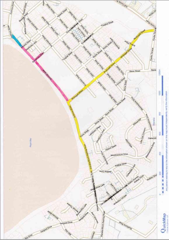
1 Wanaka Community Board 16 November 2016 Department: Property & Infrastructure Report for Agenda Item: 1 Temporary Road Closure - Challenge Wanaka Triathlon Event 2017 Purpose 1 The purpose of this report is to consider an application for temporary road closures associated with the 2017 Challenge Wanaka Triathlon event scheduled for Thursday 16 February to Sunday 19 February Executive Summary 2 Challenge Wanaka have applied to Council for a set of temporary road closures for their annual event scheduled to take place in February The event has a high number of competitors, spectators and associated infrastructure. The road closure areas are used to facilitate the construction of this infrastructure and to manage the safety of athletes and spectators by restricting access to vehicular traffic. 3 Challenge Wanaka undertake a schedule of notifications for affected businesses and residents prior to the road closures taking place and advertise widely. They will be required to obtain a number of other Council approvals prior to the event taking place and an approved Traffic Management Plan must be in place before the event occurs. 4 The event has been run successfully in the past and no formal complaints or concerns have been raised in association with the 2017 event. The recommendation is for approval of the temporary road closure application subject to conditions as per previous years. Recommendation That the Wanaka Community Board: 1. Note the contents of this report; 2. Approve the temporary road closure application for the Challenge Wanaka 2017 event subject to the following conditions: a. Approval of the final Traffic Management Plan by QLDC Planning and Development prior to the event taking place. b. Radio advertising two days prior and on the morning of the event. c. The event organisers arranging suitable disposal methods for recycling and rubbish/refuse.
2 d. The event organisers ensure access is available for emergency services and maintenance contractors if required; e. A reminder notice advising of the duration and dates of the closure being distributed to all residential and business properties located along the closure route at least ten working days prior to the event. A copy of this notice is to be supplied to APL Property Limited. f. Where safe and practical, vehicles delivering to businesses within the closure area, should be permitted by traffic management crew to undertake their deliveries and if applicable, they should be directed to appropriate detour routes. g. Clear signage is to be placed around the closure areas within the CBD advising the public that businesses in the affected area are still operating. h. Parks are not to be coned off except where required for traffic management. In those instances, cones are to be removed as soon as practical. i. The applicant providing APL Property Limited a copy of New Zealand Transport Agency's approval for the one way closure of Red Bridge. 3. Authorise the following schedule of temporary road closures: Infrastructure build up and breakdown Roads to be Closed: Ardmore Street from Dungarvon Street to McDougall Street Period of Closure: 0800 Thursday 16 February 2017 to 1800 Sunday 19 February 2017 Infrastructure Build Up and safe passage of athletes including Junior Challenge Roads to be Closed: Period of Closure: Dungarvon Street from Dunmore Street to Ardmore Street 1200 Friday 17 February 2017 to 0300 Sunday 19 February 2017 Roads to be Closed: Ardmore Street from Helwick Street to Dungarvon Street Period of Closure: 1200 Friday 17 February 2017 to 0300 Sunday 19 February 2017 Infrastructure Build Up and safe passage of athletes
3 Roads to be Closed: Ardmore Street from Helwick Street to Lakeside Road Period of Closure: 0300 Saturday 18 February 2017 to 0300 Sunday 19 February 2017 For Challenge Wanaka for safe passage for athletes and motorists Roads to be Closed: Single Lane closure of Mount Aspiring Road from Meadowstone Drive to Hospital Flat Period of Closure: 0615 to 1200 Saturday 18 February 2017 Roads to be Closed: Ardmore Street from McDougall Street to Meadowstone Drive Period of Closure: 0615 to 1730 Saturday 18 February 2017 Roads to be Closed: Single lane closure of McDougall Street from Faulks Terrace to Ardmore Street (traffic flow as usual out of town) Period of Closure: 0815 to 1730 Saturday 18 February 2017 Closure to allow safe transition of Cyclists at Aid Station Roads to be Closed: Kane Road between Camphill Road and St Ninians Way Period of Closure: 0815 to 1700 Saturday 18 February 2017 Prepared by: Reviewed and Authorised by: Sarah Mitchell APL Property Property Consultant 11/10/2016 David Wallace Manager Resource Management Engineering Queenstown Lakes District Council 7/11/2016 Background 5 Challenge Wanaka is an annual triathlon event held in Wanaka. Traffic Management New Zealand on behalf of the Challenge Wanaka Sports Trust have applied to temporarily close a set of roads in and around Wanaka CBD in order to set up associated infrastructure and run the event safely. A schedule of closures
4 and a map outlining the road closures to accompany it are appended in Attachment A. 6 In February 2017 Challenge Wanaka will celebrate its 11th event. Over the last decade it has grown from 200 to 2,000 participants and injected over $28 million into the local economy and organisers are again expecting another record field for next year's event. 7 Challenge Wanaka 2017 will again feature the Lake Wanaka Half with this event taking part on the same day as in previous years. Combined, the two events are expected to attract approximately 2,000 athletes and up to 10,000 spectators at the finish line and along the various sections of the course. 8 The Puzzling World Junior Triathlon will again take place in 2017 on Friday 17 February. This is aimed for local and visiting children to take part in a mini triathlon with the emphasis on fun and participation on a short safe course that finishes with a run through the same gantry that the triathlon will use the following day. 9 Race day is on Saturday 18 February 2017 and commences at 0530 when athletes are checked and body numbered. The swim leg takes part in Lake Wanaka followed by a two lap cycle leg from Wanaka Glendhu Bay Wanaka Hawea Luggate Wanaka being a fast route with many flat sections and a few hill climbs. 10 The final leg on the race the run is over two laps from Wanaka Outlet Track Albert Town Wanaka with athletes running along the lakeside and river track to a finish line in Pembroke Park welcoming the athletes into the night. 11 The Lake Wanaka Half runs concurrently with Challenge Wanaka with athletes starting the course 0810 with one lap of the swim, bike and run course. 12 The event involves the erection of infrastructure associated with the race and, with the large number of athletes, volunteers and spectators it attracts, the road closures are used to facilitate the construction of the infrastructure and manage spectator, volunteer and athlete safety. 13 The Council can close roads to vehicular traffic for events by using provisions of the Local Government Act The Wanaka Community Board is also delegated to consider applications to temporarily close roads under this legislation. Comment 14 Challenge Wanaka is a successful annual event attracting a large number of competitors and spectators. A large number of volunteers are also required for the event and maintaining the safety of the public, athletes and volunteers is imperative for this event to continue to run successfully. In order to achieve this temporary road closures are required to restrict vehicular traffic in the race areas.
5 15 There is, as expected for an event of this scale, infrastructure involved in running the event successfully and Council land is used to facilitate the erection of this infrastructure as part of the event. 16 In 2015 the event was changed from running in mid-january to being held in mid- February which moved it away from the Christmas/New Year period and out of the peak holiday season. This proved to be a success in 2015 and 2016 and the event organisers are again holding it in mid-february in The road closures applied for are generally the same as for the 2016 event however the road closures on Saturday 18 February 2017 for the following roads, to allow for the safe passage and transition of athletes, is proposed to begin 15 minutes earlier than in previous years: Single Lane closure of Mount Aspiring Road from Meadowstone Drive to Hospital Flat from 0615 to 1200 Ardmore Street from McDougall Street to Meadowstone Drive from 0615 to 1730 Single lane closure of McDougall Street from Faulks Terrace to Ardmore Street (traffic flow as usual out of town) from 0815 to 1730 Kane Road between Camphill Road and St Ninians Way from 0815 to The applicant has advised that these earlier road closures 15 minute earlier (and therefore longer) closure is required so the pro athletes and individuals can start the event earlier allowing the individual competitors an extra 15 minutes at the end of the day. 19 The road closure for the Red Bridge included on the attached schedule is on a State Highway so requires New Zealand Transport Agency's (NZTA) approval. The applicant will be dealing directly with the NZTA regarding this closure. 20 At last year's Wanaka Community Board meeting for the 2016 event comment was made that they would like to see people encouraged not to drive to town for the event. It was considered that an event of this nature provided a great opportunity to promote cycling as an alternative transport option and that additional bicycle parking should be provided for. 21 As 80% of the competitors are from out of town they need to drive and cannot cycle in the morning of the event as their bikes are racked in transition and they need to save their energy for the race. Challenge Wanaka want to encourage spectators from out of town to travel to the event as it increases the economic footprint for the town and they don't want to be discouraging this however they have advised that they can set up extra bike racks at the tent for parking of bikes and they will encourage spectators to cycle or walk to the event through their newsletter, web site, social media, radio advertising and athlete communication. 22 The applicant further advises that there will be extra trained road management staff to assist at Andersons Road roundabout and extra signage to divert buses
6 at the Caltex roundabout rather than have them go into the log cabin area and back out. 23 Council Engineers have been consulted and they comment that there are no issues with these road closures with an approved Traffic Management Plan in place. 24 A standard requirement of all temporary road closure approvals is that a traffic management plan is approved before the roads are closed. This will ensure that all traffic and pedestrian flows are managed with appropriate signage, barriers and wardens. The plan also considers how all Council car parks are to be managed during the closure times. 25 In association with the event, Challenge Wanaka undertake a schedule of notification for adjoining businesses and residents prior to the road closures taking place. They also advertise widely and will be required to obtain a number of other Council approvals. 26 The intent to close the road has been advertised in the Wanaka Sun and no concerns have been received following this notification. 27 The recommendation is for approval of the application, subject to the same conditions which have been applied in previous years. Options 28 This report identifies and assesses the following reasonably practicable options for assessing the matter as required by section 77 of the Local Government Act 2002: 29 Option 1 The Wanaka Community Board approves the application for temporary road closures associated with the event. Advantages: 30 Would be consistent with previous years road closures for the event and the event will be able to be run as proposed. 31 The road closure will enable safe set up of the event, safety for athletes and spectators during the event and safety during the dismantling of the event. 32 Alternative routes are available allowing traffic to still move freely around the surrounding area. Disadvantages: 33 Road closures affect the normal flow of traffic which can affect businesses and can inconvenience the public. 34 Option 2 The Wanaka Community Board declines the application for temporary road closures associated with the event.
7 Advantages: 35 There would be less inconvenience for the public that use the road with it remaining open to normal vehicular traffic. Disadvantages: 36 Would be inconsistent with previous road closures allowed for the event. 37 May mean the event will not be able to be run as planned or not at all. 38 It could create an unsafe environment for the set up and dismantling of the event and for the athletes, spectators and general public during the event. 39 Option 3 The Wanaka Community Board approves the temporary road closure with additional conditions to those recommended in this report. 40 There are no specific advantages or disadvantages to this option but the Wanaka Community Board may recommend additional conditions to the closure should it wish. 41 This report recommends Option 1 for addressing the matter it enables the Challenge Wanaka Triathlon Event 2017 to proceed as planned in a safe managed environment. Significance and Engagement 42 This matter is of medium significance, as determined by reference to the Council s Significance and Engagement Policy because it relates to closing a strategic asset (part of the roading network) for a short period of time. 43 The proposal for closure temporarily and on conditions to minimise the impact on traffic and pedestrian flows is in line with the Policy's recommendations. Risk 44 This matter relates to the strategic risk SR3 Management practise working within legislation, as documented in the Council s risk register. The risk is classed as moderate. This matter relates to this risk because the options highlighted require the Council to follow a regulatory process in order to notify the temporary closure of parts of the roading network. A variety of operational risks (such as meeting levels of service, regulatory compliance and the health and safety risks associated with parties using roads) are triggered when the Council considers whether or not to grant the temporary road closure. 45 The recommended option considered above mitigates the risk by Treating the risk - putting measures in place which directly impact the risk. The road closure is notified and the operational risks associated with granting the application are considered at the time a traffic management plan is agreed with the event organiser.
8 Financial Implications 46 There are no cost implications resulting from the approval of this temporary road closure application. The applicants will pay for any advertising that is required as part of the process. Council Policies, Strategies and Bylaws 47 The following Council policies, strategies and bylaws were considered: Criteria for Closing Significant Road Policy - Ardmore and McDougall Streets are listed in this policy as significant roads however routes in and out of Wanaka are not disrupted by the road closures with alternative detours available. Local Government Act 2002 Purpose Provisions 48 The recommended option: Will help meet the current and future needs of communities for goodquality local infrastructure, local public services, and performance of regulatory functions in a way that is most cost-effective for households and businesses by ensuring that the Challenge Wanaka 2017 Triathlon event can continue in the preferred format; Is consistent with the Council's plans and policies; and Would not alter significantly the intended level of service provision for any significant activity undertaken by or on behalf of the Council, or transfer the ownership or control of a strategic asset to or from the Council. Consultation: Community Views and Preferences 49 The temporary road closures have been advertised in The Wanaka Sun inviting comment and will be advertised again before the closures take place. This is a statutory requirement of the Local Government Act No issues or concerns have arisen from this notification. 50 Council Engineers have been consulted in the preparation of this report and they concur with the recommendations and conditions proposed. 51 A standard condition of any temporary road closure application is that the applicant provide an affected party notification to any businesses and residences within the road closure area prior to closing the road. The applicant has provided a letter to affected homeowners and businesses that will provide notification of the closure for the event to all affected parties. 52 We have publicly notified the intent to close the road, advised Emergency Services, NZ Police, Ritchies Connectabus, InterCity, Council contractors and Council staff who would have an interest in the road closures and followed the statutory administrative requirements of the Local Government Act 1974.
9 Legal Considerations and Statutory Responsibilities 53 Temporary road closures are controlled by Section 11(e) of the Local Government Act As authority for approval of these road closures is delegated to the Wanaka Community Board and considering Section 10 (2) of the Local Government Act 2002 the advice recommends a decision that is efficient, effective and appropriate to present and anticipated future circumstances. Attachments A Schedule and map of road closures
10 Challenge Wanaka 2017 Road Closure Road Closure Date and Time Purpose Alternative Route Ardmore Street from Dungarvon Street to MacDougall Street Thursday 16 February 2017 from 0800hrs to Sunday 19 February 2017 at 1800hrs Infrastructure Build up and breakdown Via Brownston Street Dungarvon Street from Dunmore Street to Ardmore Street Friday 17 February 2017 from 1200hrs to Sunday 19 February 2017 at 0300hrs Infrastructure Build up and Junior Challenge Via Helwick Street or Brownston Street Ardmore Street from Helwick Street to Dungarvon Street Friday 17 February 2017 from 1200hrs to Sunday 19 February 2017 at 0300hrs Infrastructure build up and safe passage of athletes including Junior Challenge Via Brownston Street Ardmore Street from Helwick Street to Lakeside Road Saturday 18 February 2017 from 0300hrs to Sunday 19 February 2017 at 0300hrs Infrastructure build up and safe passage of athletes Via Brownston Street Single Lane closure of Mt Aspiring Road from Meadowstone Drive to Hospital Flat Saturday 18 February 2017 from 0615hrs to 1200hrs Challenge Wanaka to allow safe passage for both athletes and motorists Via Meadowstone Drive to return to Town until road opens. Access to residents and tourism operators will be permitted Ardmore Street from MacDougall Street to Meadowstone Drive Saturday 18 February 2017 from 0615hrs to 1730hrs To allow safe passage of athletes Via Faulks Terrace and Meadowstone Drive. Access to residents permitted
11 Single Lane closure of MacDougall Street from Faulks Terrace to Ardmore Street. Traffic to flow as usual out of town Saturday 18 February 2017 from 0815hrs to 1730hrs To allow safe passage of athletes travelling at high speed down the hill Via Faulks Terrace and Meadowstone Drive or Golf Course Road. Access to Motor Camp will be provided through a traffic control point on Brownston / MacDougall Streets junction Kane Road betweencamphill Road and St Ninians Way Saturday 18 February 2017 from 0815hrs to 1700hrs To allow safe transition of cyclists at Aid Station B3 Via Camphill road and St Ninians Way One way closure of Red Bridge, Closed to North Bound Traffic Saturday 18 February 2017 from 0815hrs to 1700hrs Challenge Wanaka Event, to prevent long traffic delays to northbound traffic (a detour will be quicker) Via Shortcut Road, Wanaka Luggate Highway (SH6), Lake Hawera Albert Town Road (SH6), Camphill Road, St Ninians Way and Kane Road
12
13
QLDC Council 29 October Report for Agenda Item: 3
 QLDC Council 29 October 2015 Department: Infrastructure Beach Street Pedestrianisation Purpose Report for Agenda Item: 3 1 The purpose of this report is to obtain Council approval to consult over options
ASSOCIATION OF RUNNING CLUBS EVENT PLANNING AND RISK ASSESSMENT
 ASSOCIATION OF RUNNING CLUBS EVENT PLANNING AND RISK ASSESSMENT The purpose of this document is to inform and promote best practice for organisers of ARC permitted races. Consideration of the following
Report to Cabinet. 18 May 2016
 Agenda Item 8 Report to Cabinet 18 May 2016 Subject: Presenting Cabinet Member: Proposed CCTV Enforcement of Traffic Contraventions in a Bus Lane (Key Decision Ref. No. HE030) Highways and Environment
Update June 2018 OUR 2017 PUBLIC ENGAGEMENT
 Update June 2018 Hi, Let s Get Wellington Moving (LGWM) is developing a Recommended Programme of Investment (RPI) that meets our programme objectives and supports the city s and region s growth. As part
Roads and public rights of way
 Roads and public rights of way This factsheet outlines how the effects of the Proposed Scheme on roads and public rights of way (PRoW) along the line of route would be managed. Version 1.0 Last updated:
City of Perth Cycle Plan 2029
 Bicycling Western Australia s response City of Perth Cycle Plan 2029 2012-2021 More People Cycling More Often ABOUT BICYCLING WESTERN AUSTRALIA Bicycling Western Australia is a community based, not-for-profit
Regional Bus Priority
 Regional Bus Priority Recommendation(s) That the Board: i) Notes the systematic review for bus priority measures on the proposed Frequent Transit Network (FTN). Executive summary The New Network public
PAEKĀKĀRIKI HILL ROAD / BEACH ROAD / SH1 INTERSECTION PROGRESS REPORT
 Chairperson and Committee Members ENVIRONMENT AND COMMUNITY DEVELOPMENT COMMITTEE 6 DECEMBER 2011 Meeting Status: Public Purpose of Report: For Decision PAEKĀKĀRIKI HILL ROAD / BEACH ROAD / SH1 INTERSECTION
FAQ s Walsh Road / Ferguson Road Pilot Scheme
 FAQ s Walsh Road / Ferguson Road Pilot Scheme What is happening? Traffic calming measures are being installed as a pilot. Temporary Bollards will be installed to the east of 1 Ferguson Road and a Temporary
THE PLANNING AND. Transport and the law Integrated transport planning Strategies Responsibilities of local government and road controlling authorities
 The planning and policy context Transport and the law Integrated transport planning Strategies Responsibilities of local government and road controlling authorities THE PLANNING AND POLICY CONTEXT Providing
Report to COUNCIL for decision
 17 152 Title: Section: Prepared by: Olympic Pool Business Case Community & Recreation Andrew White (Community & Recreation Manager) Meeting Date: 18 May 2017 Legal Financial Significance = Medium Report
WANAKA SWIMMING FACILITIES STATEMENT OF PROPOSAL
 WANAKA SWIMMING FACILITIES STATEMENT OF PROPOSAL 17 October 2014 Contents Executive Summary Background National Guidelines The Status Quo Issue One Timing Issue Two Location Issue Three Size Issue Four
A guide to how local communities can change local speed limits
 A guide to how local communities can change local speed limits The Council s approach to speed management Speeding continues to be one of the key road safety concerns being raised by local communities.
Summary of Proposal to Upgrade Swimming Facilities for the Wanaka Ward
 Attachment B Summary of Proposal to Upgrade Swimming Facilities for the Wanaka Ward Introduction The Queenstown Lakes District Council is proposing to build an eight lane lap pool and a learners pool costing
Commonwealth Heads of Government Meeting: London 2018
 Commonwealth Heads of Government Meeting: London 2018 Resident and Business Factsheet Location: The Royal Parks, the Commonwealth Village and the QEII Centre Impact dates: Saturday 14 to Sunday 22 April
Regional Cycle Programme Update
 Agenda Item 10 (ii) Regional Cycle Programme Update Glossary Auckland Council Auckland Transport Cycle Action Auckland New Zealand Transport Agency Regional Cycle Network (AC) (AT) (CAA) (NZTA) (RCN) Executive
Traffic Calming Policy
 Article I. Purpose and Goal. The purpose of this policy is to establish criteria and procedures the City will use to evaluate requests for, and if appropriate, implement traffic calming measures. Neighborhood
Developing a Safer Cycling Strategy for the ACT ACRS Conference August 2012
 Developing a Safer Cycling Strategy for the ACT ACRS Conference 2012 Peter Strang Canberra Manager Sarah Court Transport Consultant 10 August 2012 Presentation Outline Background Data Analysis (Stage 1)
Active Transportation Infrastructure Investment A Business Case
 Active Transportation Infrastructure Investment A Business Case In 2016, the Real Estate Foundation awarded the Capital Regional District a $50,000 grant for Shifting Gears: Land Use Change through Active
CITY OF WEST KELOWNA COUNCIL POLICY MANUAL
 CITY OF WEST KELOWNA COUNCIL POLICY MANUAL Page 1 of 7 DEPARTMENT: Engineering Services SUBJECT: Traffic Calming Policy (Revised June 6, 2017) Policy Statement: The provision of traffic calming measures
Bus and Transit Lane Review Update
 Board Meeting / 25 February 2013 Agenda Item no.8(i) Bus and Transit Lane Review Update Glossary Auckland Transport New Zealand Transport Agency Transit Two Transit Three (AT) (NZTA) (T2) (T3) Executive
West Capitol Avenue Road Rehabilitation and Safety Enhancement Project
 West Capitol Avenue Road Rehabilitation and Safety Enhancement Project Stakeholder Focus Group Meeting #2 Tuesday, August 28, 2018 7:00 8:00 a.m. West Sacramento City Hall 1110 West Capitol Avenue, West
WHANGAREI IMPROVEMENTS
 WHANGAREI IMPROVEMENTS PROJECT OVERVIEW The NZ Transport Agency (NZTA) is working with Whangarei District Council (WDC) to improve the state highway through Whangarei. In addition to the recently completed
8 PROPOSED ROUNDABOUT DUFFERIN STREET AND KING VAUGHAN ROAD INTERSECTION CITY OF VAUGHAN
 8 PROPOSED ROUNDABOUT DUFFERIN STREET AND KING VAUGHAN ROAD INTERSECTION CITY OF VAUGHAN The Transportation Services Committee recommends the adoption of the recommendation contained in the following report
Shotover Country. Proposed Private Plan Change. Transportation Assessment Report. February 2010
 Shotover Country Proposed Private Plan Change February 2010 PO Box 13 835, Armagh Christchurch 8141 P: +64 3 379 2404 www.tdg.co.nz New Zealand Shotover Country Proposed Private Plan Change Quality Assurance
CITY OF HAMILTON PLANNING AND ECONOMIC DEVELOPMENT DEPARTMENT Transportation Planning and Parking Division
 CITY OF HAMILTON PLANNING AND ECONOMIC DEVELOPMENT DEPARTMENT Transportation Planning and Parking Division TO: Chair and Members Public Works Committee COMMITTEE DATE: June 18, 2018 SUBJECT/REPORT NO:
Chapter 7. Transportation. Transportation Road Network Plan Transit Cyclists Pedestrians Multi-Use and Equestrian Trails
 Chapter 7 Transportation Transportation Road Network Plan Transit Cyclists Pedestrians Multi-Use and Equestrian Trails 7.1 TRANSPORTATION BACKGROUND The District of Maple Ridge faces a number of unique
QLDC Council 24 July Report for Agenda Item: Fergburger Proposed Shotover Street Footpath Upgrade
 127 COU 14/07/05 QLDC Council 24 July 2014 Department: Infrastructure and Assets Report for Agenda Item: 5 5. Fergburger Proposed Shotover Street Footpath Upgrade Purpose 1 To consider a request for Council
4 DISRUPTION MANAGEMENT PLAN HIGHWAY 7 RAPIDWAY CONSTRUCTION BETWEEN BAYVIEW AVENUE AND WARDEN AVENUE TOWNS OF MARKHAM AND RICHMOND HILL
 4 DISRUPTION MANAGEMENT PLAN HIGHWAY 7 RAPIDWAY CONSTRUCTION BETWEEN BAYVIEW AVENUE AND WARDEN AVENUE TOWNS OF MARKHAM AND RICHMOND HILL The Transportation Services Committee recommends the adoption of
Strategic Director for Environment. Enclosures Appendix A - Option drawings. Jamie Blake- Strategic Director for Environment
 Chipping Barnet Area Committee 9 July 2018 Title Report of Wards Status Urgent Key Cromer Road Request for 20mph Zone Strategic Director for Environment High Barnet Public No No Enclosures Appendix A -
QUEENSTOWN LAKES DISTRICT COUNCIL STATEMENT OF PROPOSAL PEDESTRIAN MALL DECLARATION Beach Street between Camp Street and Cow Lane, Queenstown August
 QUEENSTOWN LAKES DISTRICT COUNCIL STATEMENT OF PROPOSAL PEDESTRIAN MALL DECLARATION Beach Street between Camp Street and Cow Lane, Queenstown August 2016 STATEMENT OF PROPOSAL FOR THE PEDESTRIAN MALL DECLARATION:
Dockless Cycle Share
 Dockless Cycle Share Code of Practice December 2017 135 Albert Street Private Bag 92300, Auckland 1142 aucklandcouncil.govt.nz Ph 09 301 0101 1. Introduction Auckland has seen a significant increase in
Public Works and Infrastructure Committee. General Manager, Transportation Services
 STAFF REPORT ACTION REQUIRED Extending the Bay Street Bicycle Lanes Date: May 16, 2013 To: From: Public Works and Infrastructure Committee General Manager, Transportation Services Wards: Toronto Centre
Works on Local Government Controlled Roads. & Traffic Control Permit No
 Works on Local Government Controlled Roads & Traffic Control Permit No. 171219-000220 Pursuant to Local Government Act 2009 (Section 75) This permit is valid for the following purpose(s) at the locations,
HAMILTON BIKING PLAN OUR VISION: A BIKE FRIENDLY CITY
 HAMILTON BIKING PLAN 2015-2045 OUR VISION: A BIKE FRIENDLY CITY INTRODUCTION Biking as a travel option is experiencing a resurgence internationally and in New Zealand, growing as a familyfriendly and healthy
SH3 Waitara to Bell Block
 SH3 Waitara to Bell Block NZ Transport Agency August 2017 Community feedback report Copyright information This publication is copyright NZ Transport Agency. Material in it may be reproduced for personal
Cabinet Member for Highways & Streetscene. Highway Infrastructure Manager
 LONDON BOROUGH OF RICHMOND UPON THAMES DATE: AUGUST 2015 DECISION MAKER: LEAD OFFICER: SUBJECT: WARDS: Cabinet Member for Highways & Streetscene Highway Infrastructure Manager PROPOSED CYCLING IMPROVEMENTS
APPENDIX F: TECHNICAL NOTE 22 (VICARAGE ROAD JUNCTION)
") APPENDIX F: TECHNICAL NOTE 22 (VICARAGE ROAD JUNCTION) West Midlands Interchange Transport Assessment DCO Submission WEST MIDLANDS INTERCHANGE SUBJECT: Technical Note 22 Review of Vicarage Road Junction
APPENDIX F: TECHNICAL NOTE 22 (VICARAGE ROAD JUNCTION) West Midlands Interchange Transport Assessment DCO Submission WEST MIDLANDS INTERCHANGE SUBJECT: Technical Note 22 Review of Vicarage Road Junction
Commonwealth Heads of Government Meeting: London 2018
 Commonwealth Heads of Government Meeting: London 2018 Residents and businesses factsheet, City of London Impact dates: Monday 16 Wednesday 18 April 2018 CITY OF LONDON CLOSURE AREAS 1 Location overview:
9. Parking Supporting Statement
 9. Parking Supporting Statement Content 1. Setting the Scene 2. Vision 3. Parking and the Shared Priorities 4. Issues 5. Delivery Programme in the first Plan Period 2001/02 2005/06 6. Good Practice 7.
Community engagement guide May 2018
 Community engagement guide May 2018 Greater Wellington Regional Council (GWRC), Hutt City Council (HCC) and the New Zealand Transport Agency (NZTA) are working together to achieve some big improvements
Chelmsford City Growth Package
 Chelmsford City Growth Package Public Consultation Document Volume 2 West Chelmsford July - August 2017 Chelmsford City Growth Package Public Consultation Document - Volume 2 - West Chelmsford Contents
Town of Southwest Ranches Neighborhood Traffic Calming Program
 Town of Southwest Ranches The provides residents an opportunity to present a concern for traffic safety with respect to observed volume and speeds on neighborhood streets and a formal method to study and
NM-POLICY 1: Improve service levels, participation, and options for non-motorized transportation modes throughout the County.
 Transportation PRINCE WILLIAM COUNTY 2008 COMPREHENSIVE PLAN NON-MOTORIZED PLAN CONTENTS Goals, Policies, and Action Strategies Table 4 (Bike Facility Classifications and Descriptions) Table 5 (Bike Facility
Toronto and East York Community Council. Director, Transportation Services, Toronto and East York District
 No Turn on Red Regulations STAFF REPORT ACTION REQUIRED Date: June 1, 2010 To: From: Toronto and East York Community Council Director, Transportation Services, Toronto and East York District Wards: Trinity
ETMS ADVISORY BOOKLET 1 GUIDANCE NOTES FOR ROAD CLOSURES AND DIVERSIONS
 ETMS ADVISORY BOOKLET 1 GUIDANCE NOTES FOR ROAD CLOSURES AND DIVERSIONS Version 1.0 Road Closure with Diversion ROAD CLOSURE SIGNING In Advance of the Closure At the Point of Closure STANDARD DIVERSION
Cycle traffic and the Strategic Road Network. Sandra Brown, Team Leader, Safer Roads- Design
 Cycle traffic and the Strategic Road Network Sandra Brown, Team Leader, Safer Roads- Design Highways England A Government owned Strategic Highways Company Department for Transport Road Investment Strategy
Extending 200m either side of the intersection Te Mata Mangateretere/ Waimarama/ Te Mata/River Rd
 RCA consent (eg CAR/WAP) and/or RCA contract reference TRAFFIC MANAGEMENT PLAN (TMP) FULL FORM Use this form for complex activities. Refer to the NZ Transport Agency s Traffic control devices manual, part
Woodward Hill Elementary School School Safety and Operation Review
 Address: 6082-142 nd Street Surrey, BC, V3X 1C1 Site Visit: March 7, 2011 Principal Anne Mackie Report Date: November 25, 2011 Phone: (604) 594-2408 Email: Mackie_A@sd36.bc.ca The following report is one
Chapter 2. Bellingham Bicycle Master Plan Chapter 2: Policies and Actions
 Chapter 2 Bellingham Bicycle Master Plan Chapter 2: Policies and Actions Chapter 2: Policies and Actions The Bicycle Master Plan provides a road map for making bicycling in Bellingham a viable transportation
SECTION TRAFFIC REGULATIONS
 SECTION 01550 TRAFFIC REGULATIONS PART 1 - GENERAL 1.01 OBJECTIVES A. The Contractor shall provide for safe movement of vehicular, bicycle and pedestrian traffic, including persons with disabilities in
CIRCULAR NO. O-13. Recommended Practices for Manual Protection of Highway/Railway Grade Crossings
 CIRCULAR NO. O-13 Recommended Practices for Manual Protection of Highway/Railway Grade Crossings Effective: October 1, 2004 CONTENTS 1. SCOPE 2. GENERAL PRINCIPLES 3. DEFINITIONS 4. PROTECTION REQUIRED
City of Elizabeth City Neighborhood Traffic Calming Policy and Guidelines
 City of Elizabeth City Neighborhood Traffic Calming Policy and Guidelines I. Purpose: The City of Elizabeth City is committed to ensure the overall safety and livability of residential neighborhoods. One
2. Context. Existing framework. The context. The challenge. Transport Strategy
 Transport Strategy Providing quality connections Contents 1. Introduction 2. Context 3. Long-term direction 4. Three-year priorities 5. Strategy tree Wellington City Council July 2006 1. Introduction Wellington
Traffic Calming Policy
 City of Friendswood Traffic Calming Policy May 2012 Community Development Department Table of Contents Title Page Table of contents... 1 Background and History... 2 Purpose and Goals... 2 City Procedure
Southside Road. Prepared for: City of St. John s Police & Traffic Committee. Prepared by: City of St. John s Traffic Division
 Southside Road Prepared for: City of St. John s Police & Traffic Committee Prepared by: City of St. John s Traffic Division January 2007 Southside Road - Traffic Report Page 1 of 9 BACKGROUND: th At the
RESTRICTED ROADS (20 MPH SPEED LIMIT) (SCOTLAND) BILL. 1. Is reducing the speed limit to 20mph the best way of achieving the aims of the Bill?
 (SCOTLAND) BILL. 1. Is reducing the speed limit to 20mph the best way of achieving the aims of the Bill?") RURAL ECONOMY AND CONNECTIVITY COMMITTEE RESTRICTED ROADS (20 MPH SPEED LIMIT) (SCOTLAND) BILL SUBMISSION FROM CYCLE STIRLING Questions 1. Is reducing the speed limit to 20mph the best way of achieving
RURAL ECONOMY AND CONNECTIVITY COMMITTEE RESTRICTED ROADS (20 MPH SPEED LIMIT) (SCOTLAND) BILL SUBMISSION FROM CYCLE STIRLING Questions 1. Is reducing the speed limit to 20mph the best way of achieving
CAIRNGORMS NATIONAL PARK AUTHORITY FOR DECISION
 CAIRNGORMS NATIONAL PARK AUTHORITY FOR DECISION Title: Prepared by: A9 Dualling Project: Dalraddy to Slochd Murray Ferguson, Director of Planning and Rural Development and Gavin Miles, Head of Planning
Johnwoods Street Closure Summary Response
 Johnwoods Street Closure Summary Response The following provides a summary of the major questions asked at the Public Information Meeting on May 4 th, 2016 and the responses. 1. What was the Approval Process
Bicycle Master Plan Goals, Strategies, and Policies
 Bicycle Master Plan Goals, Strategies, and Policies Mobilizing 5 This chapter outlines the overarching goals, action statements, and action items Long Beach will take in order to achieve its vision of
March Maidstone Integrated Transport Strategy Boxley Parish Council Briefing Note. Context. Author: Parish Clerk 2 March 2016
 Context. Author: Parish Clerk 2 The Draft Integrated Transport Policy (DITS) sets out a vision and objectives, and identifies a detailed programme of interventions to support the Maidstone Borough Local
1 VicRoads Access Management Policies May 2006 Ver VicRoads Access Management Policies May 2006 Version 1.02
 1 VicRoads Access Management Policies May 2006 Ver 1.02 VicRoads Access Management Policies May 2006 Version 1.02 2 VicRoads Access Management Policies May 2006 Ver 1.02 FOREWORD FOR ACCESS MANAGEMENT
Cycle Lanes Dixon Street (Worksop Road to Crayne Street)
") Cycle Lanes Dixon Street (Worksop Road to Crayne Street) Purpose of the Report To seek a decision to continue the on-road cycle lanes from Worksop Road to Crayne Street along Dixon Street in conjunction
Cycle Lanes Dixon Street (Worksop Road to Crayne Street) Purpose of the Report To seek a decision to continue the on-road cycle lanes from Worksop Road to Crayne Street along Dixon Street in conjunction
Appendix A Guiding Principles for Cycling Safety in Work Zones
 Appendix A Guiding Principles for Cycling Safety in Work Zones 1. Identify Existing Cycling Facility and Requirements This step should be part of the permitting/approval processes for construction zones
Prepared By: Town of Waxhaw Traffic Calming Policy
 Policy For Resolutions for Town Meetings Prepared By: Town Manager Michael McLaurin Director Greg Mahar CPD Waxhaw N.C. Community Planning &Development Administrative Department Department: Date Approved
Improve the livability of our streets by
 Pedestrian and Traffic Calming Policy March 2018 2 of 6 Neighborhood Traffic Calming Policy The City of Aspen continually strives to protect multimodal function while maintaining a high standard of safety.
Road Safety in Radyr and Morganstown: the Community Council's response to Cardiff Council's draft scheme layout for highway improvements
 Road Safety in Radyr and Morganstown: the Community Council's response to Cardiff Council's draft scheme layout for highway improvements Introduction Radyr and Morganstown Community Council has been invited
Welsh Triathlon. National Championship and National Series Events. Tender Process for 2018 season
 Welsh Triathlon National Championship and National Series Events Tender Process for 2018 season 1 Introduction This document is intended for event organisers interested in hosting an event that form part
12 RECOMMENDATIONS Road Improvements. Short Term (generally the next five years)
") 12 RECOMMENDATIONS Recommendations are based on the technical analysis of existing and future road and active transportation conditions, the results of the review of existing City policies and public feedback.
12 RECOMMENDATIONS Recommendations are based on the technical analysis of existing and future road and active transportation conditions, the results of the review of existing City policies and public feedback.
NOTES FROM JUNIOR COUNCIL ORIENTATION SESSION HELD ON MONDAY, JANUARY 22, 2018, AT 3:30 PM IN COUNCIL CHAMBERS, CITY HALL
 CITY OF KAMLOOPS Junior Council Meeting Agenda March 12, 2018, at 3:30 pm in Council Chambers, 7 Victoria Street West, Kamloops, BC Page 1. APPROVAL OF THE AGENDA 2. MINUTES Attachment Recommendation:
Strategy for Walking & Cycling Action Plan
 Strategy for Walking & Cycling Action Plan To achieve higher levels of walking and cycling activity, the destinations which people access have to be available within suitable distances and designed to
Exhibit 1 PLANNING COMMISSION AGENDA ITEM
 Exhibit 1 PLANNING COMMISSION AGENDA ITEM Project Name: Grand Junction Circulation Plan Grand Junction Complete Streets Policy Applicant: City of Grand Junction Representative: David Thornton Address:
CAMBRIDGE SOUTH WEST PARK & RIDE
 CAMBRIDGE SOUTH WEST PARK & RIDE Have your say on: Extra Park & Ride spaces to the south west of Cambridge Bus priority measures into the city centre CREATING MORE PARK & RIDE SPACES The existing Park
CITY OF SAINT JOHN TRAFFIC CALMING POLICY
 CITY OF SAINT JOHN TRAFFIC CALMING POLICY VERSION: 1.0 April 10, 2012 Pedestrians, Cyclists and Motorists Sharing Street Spaces CONTENTS INTRODUCTION... 3 POLICY GOAL... 3 POLICY OBJECTIVES... 3 GUIDING
Speed Limit Policy Isle of Wight Council
 APPENDIX B Speed Limit Policy Isle of Wight Council 2009 Contents Section 1 Introduction 1.1 Links with the Local Transport Plan Section 2 Speed Limits on Urban Roads and Residential Areas 2.1 20mph Limits
Downey Road. Transportation Improvement Study
 Downey Road Transportation Improvement Study Workshop 2 Participant Handbook Workshop 1 May 18 and 19, 2016 Workshop 2 June 23 and 28, 2016 Prepared By: City of Guelph Paradigm Transportation Solutions
MOBILE SHOPS, STALLS AND HAWKERS. Ashburton District Council Mobile Shops, Stalls and Hawkers Bylaw 2016 Environmental Services
 1 Bylaw MOBILE SHOPS, STALLS AND HAWKERS TITLE: TEAM: RESPONSIBILITY: Ashburton District Council Mobile Shops, Stalls and Hawkers Bylaw 2016 Environmental Services Environmental Monitoring Manager DATE
RISK ASSESSMENT FORM
 RISK ASSESSMENT FORM PLEASE NOTE: Only typed versions are now accepted, please do not submit hand written documents. EVENT NAME: Jekyll & Hyde Park Duathlon EVENT DATE: 30 October 2016 No. of day memberships
CITY OF BLOOMINGTON COMPLETE STREETS POLICY
 CITY OF BLOOMINGTON COMPLETE STREETS POLICY POLICY OBJECTIVE: The City of Bloomington will enhance safety, mobility, accessibility and convenience for transportation network users of all ages and abilities,
Watford Health Campus LLP. Watford Fields Residents Association. Re: Wiggenhall Road Junction
 Watford Health Campus Partnership LLP Watford Health Campus LLP Watford Fields Residents Association C/o Jags Shah Tempsford Hall Sandy Beds SG19 2BD 27 th January 2016 Re: Wiggenhall Road Junction Dear
Aiming for Zero Road Worker Safety. Mark Pooley Highways Agency Road Worker Safety Programme Manager Monday 11 June 2012
 Aiming for Zero Road Worker Safety Mark Pooley Highways Agency Road Worker Safety Programme Manager Monday 11 June 2012 1. Road Worker Safety Strategy. RWS Strategic Target No. 1: achieve a substantial
CITY OF OTTAWA ROADWAY MODIFICATION APPROVAL UNDER DELEGATED AUTHORITY
 RMA-2015-ATM-038 CITY OF OTTAWA ROADWAY MODIFICATION APPROVAL UNDER DELEGATED AUTHORITY DATE: April 22, 2015 SUBJECT Approval of Roadway Modifications Recommended through an Area Traffic Management Study
TRAVEL PLAN: CENTRAL EUROPEAN UNIVERSITY CAMPUS REDEVELOPMENT PROJECT TRAVEL PLAN. Central European University Campus Redevelopment Project.
 TRAVEL PLAN Central European University Campus Redevelopment Project Page 1 Table of Contents Introduction... 3 Background... 7 Building Users... 7 Transportation in Community Consultation... 7 Summary
Special Event: IRONMAN Triathlon 2016
 Special Event: IRONMAN Triathlon 2016 October 21, 2015 RECOMMENDATION THAT the Vancouver Park Board approve a request from IRONMAN, organizers of the IRONMAN 5i50 Vancouver Triathlon, for the following:
Community Transportation Plan
 Community Transportation Plan Appendix A: Traffic Calming CITY OF DECATUR COMMUNITY TRANSPORTATION PLAN Appendix A: City of Decatur City-wide Residential Traffic Calming Program Process & Procedures The
Public Information Centre
 WELCOME Public Information Centre Father Tobin Road Lougheed Middle School - Library Wednesday November 7, 2012 7:00 p.m.to 9:00 p.m. Please sign in Neighbourhood Traffic Calming Guide Background The City
TRAFFIC CALMING GUIDE FOR TORONTO CITY OF TORONTO TRANSPORTATION SERVICES DIVISION
 TRAFFIC CALMING GUIDE FOR TORONTO CITY OF TORONTO TRANSPORTATION SERVICES DIVISION CITY OF TORONTO TRANSPORTATION SERVICES DIVISION 2016 TRAFFIC CALMING GUIDE FOR TORONTO TABLE OF CONTENTS Introduction
Section 9. Implementation
 Section 9. Implementation The transportation system is just one of many aspects that must be carefully planned to maintain and enhance the quality of living in Cecil County. The Cecil County Bicycle Plan
Traffic Sensitive Streets. Guidance Notes. GeoPlace Streets Team. Traffic Sensitive Streets. Guidance Note Page 1 of 7.
 Guidance Notes GeoPlace Streets Team Guidance Note Page 1 of 7 Introduction The guidance note provides information on the definition, role and value of. It will also focus on how and why Traffic Sensitive
Agenda Item # Page # RECOMMENDATION
 TO: FROM: SUBJECT: CHAIR AND MEMBERS CIVIC WORKS COMMITTEE MEETING ON FEBRUARY 2, 2016 JOHN BRAAM, P. ENG. MANAGING DIRECTOR, ENVIRONMENTAL & ENGINEERING SERVICES AND CITY ENGINEER FIELD MARSHAL WOLSELEY
The procedures to be followed in undertaking Non-Emergency work depend on the degree of traffic disruption caused by the work.
 APPENDIX G TRAFFIC CONTROL GUIDELINES FOR UTILITY WORK WITHIN ROADWAY RIGHTS- OF-WAY JUNE 2001 Scope of Guidelines These traffic control guidelines cover work performed by utility companies and/or their
WANAKA TRANSPORT - STRATEGIC CASE
 WANAKA TRANSPORT - STRATEGIC CASE PREPARED FOR QUEENSTOWN LAKES DISTRICT COUNCIL August 2018 This document has been prepared for the benefit of Queenstown Lake District Council. No liability is accepted
Local Government Road Safety Summit - 9 April 2018
 Local Government Road Safety Summit - 9 April 2018 Report on outcomes The Associate Minister of Transport, Hon Julie Anne Genter held the Local Government Road Safety Summit in Wellington on 9 April 2018.
WELCOME. Purpose of the Open House. Update you on the project. Present a draft recommended plan. Receive your input
 WELCOME Purpose of the Open House The Town of Smiths Falls has initiated the Beckwith Street Redevelopment Plan that includes the preparation of a streetscape functional design for the renewal of Beckwith
Process for managing parking on verges, footways and footpaths
 Process for managing parking on verges, footways and footpaths Author: MG/NR Highways and Transport Environment Department Date: 28 July 2015 Version: 2.0 PARKING ON VERGES, FOOTWAYS AND FOOTPATHS Introduction
Launceston's Transport Futures. Greater travel options for the people of Launceston
 Launceston's Transport Futures Greater travel options for the people of Launceston Final Draft 13 Jan 2014 1 Page Number Executive summary 3 What is Transport Futures? 4 Vision 6 Economy, access and liveability
GD 0043/18 ACTIVE TRAVEL STRATEGY
 GD 0043/18 ACTIVE TRAVEL STRATEGY 2018-2021 May 2018 Minister s Introduction There is strong evidence that regular physical activity reduces the risk of a range of health conditions. The best way to increase
PROJECT FACT SHEET May 25, 2018
 SITE CHALLENGES & PROJECT BACKGROUND In 2014, the City of Aspen identified the Castle Creek Bridge and Hallam Street corridor as a deficient link in Aspen s bicycle and pedestrian network. Safe and efficient
TRANSPORT AND MOVEMENT
 TRANSPORT AND MOVEMENT Movement Strategy Public Transport Cycling and Walking Road Network Parking Standards Transport Impact Assessments Traffic Management Policies DRAFT POOLBEG PLANNING SCHEME Movement
Response to further information request Ministry of Education Notice of Requirement (200 & 252 Park Estate Road)
") 21 Pitt Street PO Box 6345, Auckland 1141, New Zealand T: +64 9 300 9000 // F: +64 9 300 9300 E: info@beca.com // www.beca.com Auckland Council Private Bag 92300 Victoria Street West Auckland 1142 15 August
21 Pitt Street PO Box 6345, Auckland 1141, New Zealand T: +64 9 300 9000 // F: +64 9 300 9300 E: info@beca.com // www.beca.com Auckland Council Private Bag 92300 Victoria Street West Auckland 1142 15 August