Shotover Country. Proposed Private Plan Change. Transportation Assessment Report. February 2010
|
|
|
- Audra Johns
- 5 years ago
- Views:
Transcription
1 Shotover Country Proposed Private Plan Change February 2010 PO Box , Armagh Christchurch 8141 P: New Zealand
2 Shotover Country Proposed Private Plan Change Quality Assurance Statement Prepared by: Chris Rossiter Project Transportation Engineer Reviewed by: Andy Carr Senior Associate Approved for Issue by: Andy Carr Senior Associate Status: Final Date: 11 February 2010
3 Table of Contents 1. Introduction Overview Executive Summary Existing Transport Infrastructure Site Location Existing Roading Network Public Transport Pedestrian and Cycle Network Current Travel Patterns Traffic Volumes Intersection Turning Movements Public Transport Pedestrians and Cyclists Road Safety Future Changes to the Transport Networks Road Network Passenger Transport Lake Hayes Estate Plan Change Traffic Growth Levels of Service Intersections Introduction Ladies Mile / Howards Drive Ladies Mile / Lower Shotover Road Ladies Mile / Stalker Road Summary Public Transport Walking and Cycling Description of Private Plan Change Proposed Development Road Network Traffic Generation and Distribution Traffic Generation Residential Retail Community Facilities... 31
4 7.1.4 Pre-School Primary School Park and Ride Overall Traffic Generation Traffic Distribution Effects on the Transportation Network Traffic Volumes Intersection Performance Ladies Mile / Howards Drive Ladies Mile / Lower Shotover Road Ladies Mile / Stalker Road Road Safety Mitigation of Effects District Plan Rules...42
5 1 1. Introduction 1.1 Overview Ladies Mile Partnership is applying for a private plan change to the Queenstown Lakes District Council (QLDC) District Plan. The proposal would result in land located to the east of the Shotover River and south of State Highway 6 (known locally as Ladies Mile) being rezoned from Rural General to Shotover Country Special Zone. This will facilitate a mix of residential environments as well as a primary school and a small commercial precinct. This evaluates the potential transportation-related effects of the proposed rezoning on the existing and future transport networks, and includes a consideration of relevant strategic transportation strategies and policies. While this report includes an assessment of travel by private motor vehicle, it also recognises the importance of other forms of transport and consequently consideration has also been given to public transport, walking and cycling. 1.2 Executive Summary Without the proposed plan change, the intersection modelling undertaken shows that by 2021, level of service LOS F occurs for right-turning vehicles at the State Highway 6 / Howards Drive, State Highway 6 / Lower Shotover Road and State Highway 6 / Stalker Road intersections. The modelled delays are more significant in the evening peak hour than in the morning and it is considered that the delays for traffic emerging from Lower Shotover Road and potentially Howards Drive are such that in practice changes in driver behaviour will occur. Some drivers may use an alternative route, others will firstly turn left and then u-turn on the highway, and some will accept smaller gaps in the traffic streams before turning right onto the highway. The latter are likely to have consequential adverse effects upon road safety and so it is likely that prior to 2021, NZTA will have to undertake some form of improved traffic management or intersection improvement scheme most likely at Lower Shotover Road. At this stage it is considered that a roundabout is the most likely scheme. The predicted traffic generation for the proposed plan change has been based on the trip generation rates published by the New Zealand Trips and Parking Database. However, since the non-residential activities are primarily intended to serve the local community (including the Lake Hayes Estate) it is not expected that these will attract significant numbers of trips from outside the site. Similarly, the presence of the non-residential land uses will also mean that some trips made from the residential land uses will not be required to be made externally and this will potentially also affect the trip generation from Lake Hayes Estate. Scenarios have been assessed with and without a potential Park and Ride scheme. With regard to the nearby intersections on the state highway, in the morning peak hour there are very little effects at the State Highway 6 / Howards Drive, State Highway 6 / Lower Shotover Road and State Highway 6 / Stalker Road intersections with the traffic associated with the proposed plan change and with the Park and Ride operating. In the evening peak hour, at the State Highway 6 / Howards Drive intersection there are significant increases in the delays from right-turning vehicles with the Park and Ride site in place. This is due to those drivers who have used the Park and Ride facility seeking to emerge back onto the highway having switched mode from bus back to their car. Conversely, the scheme will by its nature serve to support sustainable transport and to reduce traffic volumes on the state
6 2 highway to the west of the intersection. As a result, there are beneficial effects on delays at the State Highway 6 / Lower Shotover Road and State Highway 6 / Stalker Road intersections associated with having the Park and Ride. Notwithstanding this, it is considered that the effects of the plan change at State Highway 6 / Lower Shotover Road are somewhat academic in that the extent of delays for right-turning vehicles from Lower Shotover Road with or without the Plan Change site are such that improvements to this intersection will be required before 2021 regardless of whether the plan change is approved or not. As noted previously, this is likely to be in the form of a roundabout. Since in the evening the delays for right turning vehicles at Stalker Road increase to 4.5 minutes or 5.7 minutes (with the plan change, but with or without the Park and Ride respectively), it is considered that Stalker Road could be realigned such that the roundabout would have four approaches. A preliminary assessment of a nominal roundabout layout shows that level of service LOS C or better for each turning movement would occur in 2021 (including the right-turn movements) with the plan change approved but without the Park and Ride operating. It is envisaged that there may be occasional departures from the District Plan Rules and Council s Development and Subdivision Engineering Standards (Amendments and Modifications to NZS4404:2004) in order to achieve the optimum urban design outcome. Such departures would be consistent with Council strategies, but will be discussed with Council at subdivision design stage. Accordingly, on the basis of the assessment undertaken, it is considered that there are no traffic or transportation-based reasons why this proposed Plan Change should not be approved.

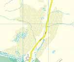
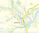
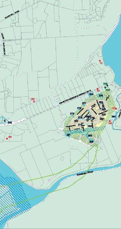
7 3 2. Existing Transport Infrastructure 2.1 Site Location Figure 1 shows the location of the plan change site, located about 9km to the east of Queenstown and to the immediate west of Lake Hayes Estate. State Highway 6 (known in this location as Ladies Mile) lies towards the north. The site is currently zoned as Rural General as shown on Figure 2. The zoning of the land surrounding the site is also shown on this Figure. Figure 3 shows the roading hierarchy in the immediate area. 2.2 Existing Roading Network The site is presently served by Stalker Road, a Local Road under the District Plan roading hierarchy indicating a role in providing for local property access. Stalker Road is approximately 6m wide and runs with a curvilinear (but approximately north-south) alignment serving several residential properties. It is sealed but does not have either a centreline or edgeline markings. Photograph 1: Stalker Road looking south At its northern extremity, Stalker Road meets State Highway 6 (Ladies Mile) at a priority controlled ( give way ) intersection. The intersection includes auxiliary turn lanes for both left and right turning vehicles from Ladies Mile. The right turn bay on the highway is 3.7m wide and 20m long with a 20m taper, and the left turn lane is 3.5m wide and 122m long with a 50m long taper. Stalker Road is flared on the immediate approach to the intersection such that one left-turning vehicle can wait alongside a right-turning vehicle.

8
9
10

11 7 Photograph 2: Ladies Mile / Stalker Road intersection looking east Ladies Mile is a main strategic link through the district, forming part of the state highway network connecting Queenstown with Kingston and Invercargill to the south and to Cromwell, Wanaka and the wider strategic network throughout the South Island. At its intersection with Stalker Road, Ladies Mile provides one 3.5m traffic lane in each direction and runs with a straight and flat eastwest alignment. The speed limit in this location is 100km/h. To the immediate west of the intersection however, the highway turns slightly northwards and descends to cross the Shotover River before rising again and linking to State Highway 6A (Frankton Road) some 2.6km to the west. At this point, State Highway 6 turns southwards and State Highway 6A forms the primary roading link into Queenstown. Some 70m east of the Ladies Mile / Stalker Road intersection, Lower Shotover Road joins Ladies Mile from the north. Lower Shotover Road is a Collector Road under the District Plan roading hierarchy, with a function of accommodating both local property access and through traffic. Generally, it runs with a north-south alignment to link to Malaghans Road (and hence to Arrowtown) 5.8km to the north and has an approximate 7m seal width. At the Ladies Mile / Lower Shotover Road intersection, auxiliary turn lanes for both left and right turning vehicles from Ladies Mile are provided. The right turn bay on the highway is 3.5m wide and 20m long with a 20m taper, and the left turn lane is 3.6m wide and 125m long with a 50m long taper. Lower Shotover Road is flared on the immediate approach to the intersection such that two left-turning vehicles can wait alongside right-turning vehicles. At the time of writing (February 2010) a minor improvement scheme was being constructed at the intersection with the left-turn lane being set back from the through traffic lane in order to provide increased segregation between the traffic streams and improve road safety.
 intersection.")

12 8 Photograph 3: Ladies Mile / Lower Shotover Road intersection looking east Some 0.8km east of Lower Shotover Road, Howards Drive joins Ladies Mile from the south at a priority ( give-way ) intersection. Howards Drive is the sole access into Lake Hayes Estate. Both left-turning and right-turning lanes are provided for vehicles turning from the highway onto Howards Drive, and Howards Drive is flared to allow for one vehicle to emerge and turn left while another emerges and turns right. Photograph 4: Ladies Mile / Howards Drive intersection looking west
13 9 Old School Road is a narrow, unsealed road that runs along the western side of the plan change site and provides a small number of properties. It passes underneath Ladies Mile adjacent to the Shotover Bridge and meets Spence Road a further 250m to the north. Spence Road provides a connection to Ladies Mile via Lower Shotover Road. 2.3 Public Transport There is presently no public transport infrastructure provided in the immediate vicinity of the site. 2.4 Pedestrian and Cycle Network There are currently no footpaths or specific provisions for cyclists on Ladies Mile or the existing section of Stalker Road.
14 10 3. Current Travel Patterns 3.1 Traffic Volumes Data has been obtained from QLDC and the New Zealand Transport Agency for the most recent traffic counts carried out in the vicinity of the site. The results are summarised in Table 1 below. Location Date Average Daily Traffic Volume Average Weekday Traffic Volume Ladies Mile (east of Lower Shotover Rd) October ,700 10,100 Howards Drive April ,900 - Lower Shotover Road July ,500 - Table 1: Traffic Volumes Table 1 shows that the pattern of traffic volumes on the network is dominated by the state highway, with more than three times more traffic than on the other roads, commensurate with its role in the roading hierarchy. The traffic volume on Howards Drive is higher than would normally be associated with a local road and is significantly higher than an ADT recorded in October 2005 of 1,700vpd. This difference is likely to reflect the growth in development of the estate over that time. However it does suggest that Howards Drive is perhaps better considered as performing the function of a Collector Road. Figure 4 shows the variation in the hourly traffic volumes over a week-long period on Ladies Mile in October The hourly profiles in each direction indicate a strong commuter travel pattern with high two-way peak hour traffic volumes in both the morning and evening peak periods. Based on this count data, the morning peak hour traffic volume between 8am and 9am was 880 vph with about 70% of all traffic being westbound. During the weekday evening peak period, 5pm to 6pm, the average two-way traffic volume was 1,100vph with 65% of vehicles being eastbound. Figure 5 shows a similar pattern for Howards Drive, albeit as a combined (two-way) flow. Nevertheless, given the wholly residential nature of Lake Hayes Estate it is of use to demonstrate the overall traffic patterns, notably that the morning peak period appears to be spread over two hours with a much shorter (one hour) evening peak period. 3.2 Intersection Turning Movements Figure 6 shows intersection turning movements at the Ladies Mile intersections with Lower Shotover Road and Howards Drive based upon surveys undertaken in It will be noted that the surveys indicated that the morning and evening peak periods differ very slightly from the peak periods indicated by the automated count on the state highway. At Howards Drive, 90% of all outbound traffic turned left towards Queenstown in the morning peak while only 70% of inbound traffic was from the west. At the Lower Shotover Road intersection, the directional split differed with only 60% of vehicles turning towards Queenstown in the morning peak. In the evening peak period, 85% of the vehicles turning into Howards Drive were from the west which is consistent with a commuter travel pattern to Queenstown. Westbound vehicles from Lake Hayes Estate still accounted for 75% of all outbound movements. As with the morning peak, there was a different directional split for the traffic movements at Lower Shotover Road with 60% of inbound movements being from the west.
15 Southbound Traffic Volume (vph) SH6 East Lower Shotover Rd (Southbound) MON TUE WED THU FRI SAT SUN Week Beginning Wed 07-Oct-09 SH6 East Lower Shotover Rd (Northbound) Northbound Traffic Volume (vph) MON TUE WED THU FRI SAT SUN Week Beginning Wed 07-Oct-09 SH6 East Lower Shotover Rd (Combined) Combined Traffic Volume (vph) MON TUE WED THU FRI SAT SUN Week Beginning Wed 07-Oct-09
16 Howards Drive (Two-Way) Two-Way TRAFFIC VOLUME (vph) MON TUE WED THU FRI SAT SUN WEEK BEGINNING MON 27-APR-09
17
18 Public Transport The Connectabus service passes by the site en route to Lake Hayes Estate and Arrowtown. The service from Arrowtown to Queenstown is hourly between 6:30am and 7pm. In the opposite direction, the service is also hourly but continues into the late evening with the last departure from Queenstown at 11:15pm. There are also several school buses which pass along Ladies Mile. 3.4 Pedestrians and Cyclists While no formal surveys have been undertaken, informal observations of pedestrians and cyclists in the area indicate low levels of activity. This is perhaps not surprisingly, given the comparative lack of destinations within a viable walking or cycling distance. 3.5 Road Safety The New Zealand Transport Agency Crash Analysis System (CAS) has been used to assess the accident history on Ladies Mile between Tucker Beach Road (1.3km west of Stalker Road) and McDowell Drive (1.1km east of Howards Drive). The search identified all reported accidents which occurred in the five year period from 2004 to 2008 inclusive and the partial record available for The search revealed that there have been 16 injury and 23 non-injury accidents during the review period. Ten of these occurred at intersections. Figure 7 shows the type and location of all accidents reported with the most common accident locations summarised below: Seven accidents were reported at the Ladies Mile / Lower Shotover Road intersection. Ten accidents occurred at the eastbound passing lane leading up to the Ladies Mile / Lower Shotover Road intersection. Eight accidents were reported on the Shotover River Bridge and a further accident occurred when a truck attempted to drive under the bridge and hit the bridge with its hydraulic tip tray extended. There were no cyclist or pedestrian accidents reported (potentially reflecting the generally minimal levels of cycle or pedestrian activity). The passing lane west of Ladies Mile / Lower Shotover Road provides an overtaking opportunity for eastbound traffic on the highway. All of the reported accidents at the passing lane involved vehicles travelling in the eastbound direction. Of these seven were reported to be a result of ice on the road, where vehicles lost control while overtaking. Similarly all of the accidents at the Ladies Mile / Lower Shotover Road intersection involved vehicles travelling in an eastbound direction. This is despite the intersection having been relocated further east approximately four to five years ago, and the consequent improvement in sight distance in this direction. A further improvement scheme is underway (as at February 2010) with the left-turn lane being set back from the through traffic lane and separated by a painted hatched area. It is understood from NZTA that the scheme is intended to provide increased segregation between the traffic streams and improve road safety. The accidents occurring on the Shotover Bridge did not have any apparent common factors. Insecure loads, objects thrown from vehicles, ice, erratic driver behaviour and rear end collisions as a result of travelling too fast at temporary speed limits were all reported as accident factors.
19
20 16 4. Future Changes to the Transport Networks 4.1 Road Network The final report of the Wakatipu Transportation Strategy, a study commissioned by QLDC, was issued in November It is considered that there are many aspects to the Strategy that will directly affect travel demands across the Frankton Flats and therefore, the travel demands at the plan change site. The most significant of these is the stated desire to effect a significant change in travel behaviour with a critical objective of the Wakatipu Transportation Strategy being the need to reduce the predicted future traffic volumes on SH6A Frankton Road to prevent bumper to bumper traffic travelling at an average speed of 20km/h by It is expected that this will be achieved through the development of more frequent public transport services and parking restraint in Queenstown along with Park-and-Ride facilities in Frankton Flats. The final report states that it is estimated that these measures could translate to approximately a 20% transfer of car trips to public transport by The Wakatipu Transportation Strategy does not identify any targets for years before 2026 but indicates that a travel demand management programme would be initiated in the short term along with implementation of a high quality bus service. Also in the short term is the initial Implementation of park and ride schemes, continuing into the medium term as facilities are expanded. The Wakatipu Transportation Strategy identified seven road infrastructure improvement projects for the Frankton Flats. Three of these projects will directly affect future residents of the plan change site travelling to or from Queenstown while another project will provide a new link to the Remarkables Park Zone (RPZ) to the south of the airport. These include the construction of a new arterial road, the Eastern Access Road from State Highway 6 west of Glenda Drive, around the east end of the runway, through the RPZ and connecting with Hawthorne Drive, as shown in Figure 8. As part of the construction of this, the State Highway 6 / Glenda Drive intersection will also be modified and Glenda Drive will be separately linked to the Eastern Access Road. The staging strategy contained within the Wakatipu Transportation Strategy indicates that these improvements will be planned for the short term. The Glenda Drive intersection improvements are highlighted as urgent for road safety and efficiency reasons and should occur before Based upon the observed growth in traffic volumes on State Highway 6 and the additional traffic anticipated from proposed developments both east and south of Frankton, the State Highway 6/6A intersection (Frankton roundabout) is envisaged by the Wakatipu Transportation Strategy to become a point of significant congestion in the near future. The strategy indicates that an intersection upgrade will be required in the medium term ( ). This is likely to be implemented in conjunction with a public transport priority project for Frankton Road that aims to reduce traffic volumes through the introduction of park and ride schemes. With the development enabled by the existing Frankton Flats Special Zone and also by the proposed Plan Change 19 (PC19) which is currently under appeal, significant growth in the traffic volumes using Grant Road is expected. The Wakatipu Transportation Strategy anticipates these developments and the construction of a roundabout at the State Highway 6 / Grant Road intersection was proposed for the short term. Since that time, the major developer in the immediate vicinity (Five Mile Holdings Limited) has gone into receivership and the status of the roundabout at present is uncertain. However, the recently announced change of ownership and proposed development of the Frankton Flats Special Zone may suggest that the roundabout could be constructed in the short to medium term.
21
22 Passenger Transport Figure 9 indicates the proposed bus routes from the Wakatipu Transportation Strategy. Most of the routes use Frankton Road and it is proposed that public transport priority measures be instigated for this road as part of travel demand management proposals designed to encourage the use of travel modes other than private motor vehicles. As part of travel demand management measures, the Strategy proposes management of parking availability, particularly in central Queenstown, as a way to discourage commuter traffic and as an incentive to use the new public transport systems. Park and Ride facilities are also proposed within the northern sector of the Frankton Flats so that motorists can interchange to buses for the journey along Frankton Road. Although the location of the park and ride sites has not been determined at this time, it is of note that their location will influence the level of reduction in traffic volumes that will be achieved on the state highway across the Frankton Flats. 4.3 Lake Hayes Estate Lake Hayes Estate has not been fully developed, and in future traffic volumes on Howards Drive will increase as a result of further residences being developed and occupied. A survey undertaken by Clark Fortune McDonald Associates in November 2009 indicated around 380 residences were constructed with a further 107 lots either vacant or with a dwelling under construction. Applying the number of residences to the April 2009 traffic value (2,900 vehicles per day) indicates a trip generation rate of 7.6 vehicle movements per residence. Given that potentially slightly fewer houses were constructed at the time of the survey, this bears a very close similarity to the design volume set out in Council s standards of 8 vehicle movements per residence per day. The data also shows that 0.61 vehicle movements per residence occurred between 7am to 8am and 0.87 vehicle movements per residence occurred between 8am to 9am. Conversely, the evening peak period occurred over a much shorter period with 0.94 vehicle movements per residence made between 5pm and 6pm. In order to ensure that the full development of Lake Hayes Estate is included within the receiving environment, these peak hour figures have been applied to the total amount of permitted development (that is, allowing for an additional 107 lots) within the future year scenarios considered within this report. These analyses are set out subsequently. 4.4 Plan Change 19 Proposed Plan Change 19 will enable mixed-use development of rural land between Queenstown Airport and State Highway 6. The proposed structure plan includes residential and retail/commercial activity areas located beside the existing Frankton Flats Special Zone with access from Grant Road. Around this new town centre, the land could be developed for light industrial purposes with the primary access route being the Eastern Access Road. One outcome of this is that the proximity of the PC19 land to the Ladies Mile site means that it will provide a source of employment opportunities that are within a practical cycling distance of the site, which may serve to diminish car-borne journeys. No reduction in vehicular trip rates has been made for this however within the following analyses.
23
24 Traffic Growth Table 2 shows the average daily traffic volumes on Ladies Mile east of Lower Shotover Road since Year Average Daily Traffic Volume , , , , ,800 Table 2: State Highway Traffic Volumes This shows that between 2004 and 2008 the annual average daily traffic volumes increased by the equivalent of 450 vehicles per day each year, or 5.6% per annum relative to the 2004 traffic survey. It will be noted however that volumes reduced between 2007 and In their formal reporting, NZTA noted that a reduction in traffic occurred over the whole of the state highway network in this period with 2008 traffic flows being similar to those of 2006, but did not offer any explanation for this. For the purposes of the analyses in this report, a design year of 2021 has been adopted and traffic growth at a rate of 450 additional vehicles per day each year on the state highway has been allowed for, being a continuation of the existing rate of traffic growth.
Harriet Fraser Traffic Engineering & Transportation Planning
 Appendix 5: Traffic Assessment 71 26 February 2015 Mr James Beban Senior Resource Consents Planner Cuttriss Consultants Ltd PO Box 30429 Lower Hutt PO Box 40170 Upper Hutt 5140 P 04 526 2979 M 027 668
Ministry of Education Flat Bush School Notice of Requirement. Integrated Transportation Assessment Report. February 2016
 Ministry of Education Flat Bush School Notice of Requirement Integrated Transportation Assessment Report February 2016 TDG Ref: 12988-2 151105 ita flat bush.docx Ministry of Education Flat Bush School
Transport Assessment. Curtis Street Plan Change
 Transport Assessment Curtis Street Plan Change Transport Assessment for Curtis Street Plan Change i Contents 1. Introduction... 1 2. Existing Conditions... 2 2.1 Location... 2 2.2 Study Area... 3 2.3
North West Non-Technical Summary of the Transport Assessment September 2011
 North West Non-Technical Summary of the Transport Assessment September 2011 Introduction This is a Non-Technical Summary of the findings of the Transport assessment work undertaken for the proposed North
Auranga B1 Proposed Plan Change, Bremner Road, Drury. Integrated Transportation Assessment Report
 Auranga B1 Proposed Plan Change, Bremner Road, Drury Integrated Transportation Assessment Report 12 May 2017 Project: Report title: Document reference: Proposed Plan Change, Bremner Road, Drury Integrated
QUEENSTOWN TOWN CENTRE TRANSPORT STRATEGY
 QUEENSTOWN TOWN CENTRE TRANSPORT STRATEGY Consultation Document April 2015 This is a summary of the Draft Strategy, which is on the Council s website at www.qldc.govt.nz The summary is designed as an introduction
Ministry of Education Notice of Requirement, North City High School. Transportation Assessment Report. July 2010
 Ministry of Education Notice of Requirement, North City High School Transportation Assessment July 2010 PO Box 1261, Level 1, 7 Hardley Street Hamilton 3240 P: +64 7 839 550 www.tdg.co.nz New Zealand 10574ta_v6.doc
PAEKĀKĀRIKI HILL ROAD / BEACH ROAD / SH1 INTERSECTION PROGRESS REPORT
 Chairperson and Committee Members ENVIRONMENT AND COMMUNITY DEVELOPMENT COMMITTEE 6 DECEMBER 2011 Meeting Status: Public Purpose of Report: For Decision PAEKĀKĀRIKI HILL ROAD / BEACH ROAD / SH1 INTERSECTION
PROPOSED RESIDENTIAL SUBDIVISION
 PROPOSED RESIDENTIAL SUBDIVISION PART OF TARNEIT ROAD & 1121 DOHERTYS ROAD, TARNEIT Prepared For: TCG (RM) Developments Pty Ltd MARCH 2014 OUR REF: 16740R#1 PROPOSED RESIDENTIAL SUBDIVISION PART OF TARNEIT
SH1 Western Belfast Bypass Transportation Assessment
 SH1 Western Belfast Bypass Transportation Assessment WBB- Transportation Assessment i This report has been prepared on behalf of the NZ Transport Agency (NZTA). No liability is accepted by this company
CITY OF OTTAWA ROADWAY MODIFICATION APPROVAL UNDER DELEGATED AUTHORITY
 RMA-2015-ATM-038 CITY OF OTTAWA ROADWAY MODIFICATION APPROVAL UNDER DELEGATED AUTHORITY DATE: April 22, 2015 SUBJECT Approval of Roadway Modifications Recommended through an Area Traffic Management Study
2. Context. Existing framework. The context. The challenge. Transport Strategy
 Transport Strategy Providing quality connections Contents 1. Introduction 2. Context 3. Long-term direction 4. Three-year priorities 5. Strategy tree Wellington City Council July 2006 1. Introduction Wellington
Kings College, Otahuhu Proposed Plan Change. Integrated Transportation Assessment Report
 Proposed Plan Change Integrated Transportation Assessment Report 23 October 2017 Project: Report title: Document reference: Kings College, Otahuhu Integrated Transportation Assessment Report J00700 Kings
Port Otago Ltd SH88 TRANSPORT REVIEW. September PO Box Christchurch Phone : New Zealand
 Port Otago Ltd SH88 TRANSPORT REVIEW September 2008 PO Box 13-835 Christchurch Phone : +64 3 379 2404 New Zealand SH88 Transport Review QUALITY ASSURANCE STATEMENT Prepared by: Andrew Metherell Principal
Appendix C. NORTH METRO STATION AREA TRAFFIC IMPACT STATEMENT 88th Avenue Station
 Appendix C NORTH METRO STATION AREA TRAFFIC IMPACT STATEMENT 88th Avenue Station Prepared for: Regional Transportation Department and URS Corporation as part of the North Metro EIS David Evans and Associates,
1.5 On this basis it is fundamental that the Transport Strategy for the site focuses on the following key criteria,
 1.0 Introduction 1.1 The Transport Assessment has been prepared on behalf of Eon and Roger Bullivant Ltd in respect of the proposed mixed use sustainable urban extension of Drakelow Park. 1.2 The methodology
City of Wayzata Comprehensive Plan 2030 Transportation Chapter: Appendix A
 A1. Functional Classification Table A-1 illustrates the Metropolitan Council s detailed criteria established for the functional classification of roadways within the Twin Cities Metropolitan Area. Table
Statement of Evidence of Judith Makinson
 In the Matter of: The Resource Management Act 1991 and In the Matter of: Podium Sports Lodge, 18 20 Peake Road Application By: Brian Perry Charitable Trust Statement of Evidence of Judith Makinson TDG
Traffic and Transport Assessment
 Traffic and Transport Assessment Section 96 Residential Subdivision, Davis Road Tarneit CG120370 Prepared for Stockland Pty Ltd 19 February 2013 Document Information Prepared for Stockland Pty Ltd Project
Chelmsford City Growth Package
 Chelmsford City Growth Package Public Consultation Document Volume 2 West Chelmsford July - August 2017 Chelmsford City Growth Package Public Consultation Document - Volume 2 - West Chelmsford Contents
GD 0043/18 ACTIVE TRAVEL STRATEGY
 GD 0043/18 ACTIVE TRAVEL STRATEGY 2018-2021 May 2018 Minister s Introduction There is strong evidence that regular physical activity reduces the risk of a range of health conditions. The best way to increase
WHANGAREI IMPROVEMENTS
 WHANGAREI IMPROVEMENTS PROJECT OVERVIEW The NZ Transport Agency (NZTA) is working with Whangarei District Council (WDC) to improve the state highway through Whangarei. In addition to the recently completed
9. Parking Supporting Statement
 9. Parking Supporting Statement Content 1. Setting the Scene 2. Vision 3. Parking and the Shared Priorities 4. Issues 5. Delivery Programme in the first Plan Period 2001/02 2005/06 6. Good Practice 7.
Corporate. Report COUNCIL DATE: May 25, 1998 NO: R1500 REGULAR COUNCIL. TO: Mayor & Council DATE: April 27, 1998
 R1500 : Traffic Safety at 25 Avenue and 128 Street Intersection Corporate NO: R1500 Report COUNCIL DATE: May 25, 1998 REGULAR COUNCIL TO: Mayor & Council DATE: April 27, 1998 FROM: General Manager, Engineering
Berwick Health and Education Precinct: Casey Amendment C207 (Part 1) Submission to Planning Panels Victoria
 Submission to Planning Panels Victoria") Berwick Health and Education Precinct: Casey Amendment C207 (Part 1) Submission to Planning Panels Victoria August 2018 CONTENTS 1 Executive summary... 1 2 Summary of the amendment... 2 3 Submission...
Berwick Health and Education Precinct: Casey Amendment C207 (Part 1) Submission to Planning Panels Victoria August 2018 CONTENTS 1 Executive summary... 1 2 Summary of the amendment... 2 3 Submission...
METHODOLOGY. Signalized Intersection Average Control Delay (sec/veh)
") Chapter 5 Traffic Analysis 5.1 SUMMARY US /West 6 th Street assumes a unique role in the Lawrence Douglas County transportation system. This principal arterial street currently conveys commuter traffic
Chapter 5 Traffic Analysis 5.1 SUMMARY US /West 6 th Street assumes a unique role in the Lawrence Douglas County transportation system. This principal arterial street currently conveys commuter traffic
APPENDIX H EXISTING TRAFFIC CONDITIONS ANALYSIS
 APPENDIX H EXISTING TRAFFIC CONDITIONS ANALYSIS MEMO : Peter Steacy, P.Eng. Date: December 3, 2014 : Ian Borsuk, P.Eng. Job No.: 3414015-000 Subject: City of Ottawa O-Train Extension Planning & EA Study
Traffic Impact Study WestBranch Residential Development Davidson, NC March 2016
 Traffic Impact Study WestBranch Residential Development Davidson, NC March 216 TRAFFIC IMPACT STUDY FOR THE WestBranch Residential Development LOCATED IN DAVIDSON, NC Prepared For: Lennar Carolinas, LLC
Douglas Land Use and Transportation Strategy (DLUTS) Summary. August 2013
 Summary. August 2013") Douglas Land Use and Transportation Strategy (DLUTS) Summary August 2013 Background Douglas is a large and popular residential suburb of approximately 30,000 persons on the periphery of Cork City along
Douglas Land Use and Transportation Strategy (DLUTS) Summary August 2013 Background Douglas is a large and popular residential suburb of approximately 30,000 persons on the periphery of Cork City along
MILTON ROAD LLF PROJECT UPDATE
 Greater Cambridge City Deal MILTON ROAD LLF PROJECT UPDATE 9 th May 2017 Project objectives Comprehensive priority for buses in both directions wherever practicable; Additional capacity for sustainable
The Safe System Approach
 There are very few areas of public discussion and sentiment which generate as much consensus as road safety. Everyone wants safer roads for all users, and road safety is a key priority for governments,
Classification Criteria
 SCHEDULE D TO RECOMMENDED OFFICIAL PLAN AMENDMENT NO. 40 SCHEDULE C-4 Road Criteria Criteria Traffic Service Objective Land Service/Access Typical Daily Traffic Volume Flow characteristics Travel Speed
TRAFFIC IMPACT ANALYSIS
 TRAFFIC IMPACT ANALYSIS FOR THE CHAMPAIGN UNIT#4 SCHOOL DISTRICT PROPOSED HIGH SCHOOL (SPALDING PARK SITE) IN THE CITY OF CHAMPAIGN Final Report Champaign Urbana Urbanized Area Transportation Study 6/24/2014
2014/2015 BIKE ROUTE PLAN 83 AVENUE PROTECTED BIKE LANE
 About the Project 2014/2015 BIKE ROUTE PLAN The City of Edmonton is planning a major bike route on the south side of Edmonton. This bike route is one part of a plan to provide citizens with transportation
URBAN QUARRY HEADQUARTERS 2717 STEVENAGE DRIVE CITY OF OTTAWA TRANSPORTATION OVERVIEW. Prepared for: Urban Quarry 4123 Belgreen Drive, Ottawa K1G 3N2
 URBAN QUARRY HEADQUARTERS 2717 STEVENAGE DRIVE CITY OF OTTAWA TRANSPORTATION OVERVIEW Prepared for: Urban Quarry 4123 Belgreen Drive, Ottawa K1G 3N2 February 27, 2014 113-584 Overview_1.doc D. J. Halpenny
1 VicRoads Access Management Policies May 2006 Ver VicRoads Access Management Policies May 2006 Version 1.02
 1 VicRoads Access Management Policies May 2006 Ver 1.02 VicRoads Access Management Policies May 2006 Version 1.02 2 VicRoads Access Management Policies May 2006 Ver 1.02 FOREWORD FOR ACCESS MANAGEMENT
DYNAMIC LANES FOR AUCKLAND
 Dynamic Lanes for Auckland MENEZES M. and INMAN R. Page 1 DYNAMIC LANES FOR AUCKLAND Authors: INMAN, Robert BA (Hons) Previously Auckland Transport Senior Traffic Engineer Now Aurecon Robert.Inman@aurecongroup.com
Response to further information request Ministry of Education Notice of Requirement (200 & 252 Park Estate Road)
") 21 Pitt Street PO Box 6345, Auckland 1141, New Zealand T: +64 9 300 9000 // F: +64 9 300 9300 E: info@beca.com // www.beca.com Auckland Council Private Bag 92300 Victoria Street West Auckland 1142 15 August
21 Pitt Street PO Box 6345, Auckland 1141, New Zealand T: +64 9 300 9000 // F: +64 9 300 9300 E: info@beca.com // www.beca.com Auckland Council Private Bag 92300 Victoria Street West Auckland 1142 15 August
TRAFFIC IMPACT STUDY And A TRAFFIC SIGNAL WARRANT ANALYSIS FOR A SENIOR LIVING AND APARTMENT DEVELOPMENT
 TRAFFIC IMPACT STUDY And A TRAFFIC SIGNAL WARRANT ANALYSIS FOR A SENIOR LIVING AND APARTMENT DEVELOPMENT DEERFIELD TOWNSHIP, WARREN COUNTY, OHIO Nantucket Circle and Montgomery Road () Prepared for: ODLE
DRAFT for a State Policy for Healthy Spaces and Places
 DRAFT for a State Policy for Healthy Spaces and Places 1 DRAFT State Policy for Healthy spaces and Places 1. Purpose To encourage the use and development of land that builds healthy communities through
A127/A130 Fairglen Interchange Improvement Schemes. Information Leaflet February 2017
 A127/A130 Fairglen Interchange Improvement Schemes Information Leaflet February 2017 1 2 Foreword By Councillor Kevin Bentley Essex is continuing to grow as a vibrant economic hub and as a fantastic place
Technical note. 1. Introduction
 Project: A428 study - Phase 2 To: Adrian Shepherd Subject: Park & Ride site locations From: Atkins Date: Jun 3, 2016 cc: Ashley Heller 1. Introduction 1.1. Purpose of Technical Note The purpose of this
Statement of Rebuttal Evidence of Anthony Thomas Penny on Behalf of Danne Mora Holdings (#1134)
") In the Matter of: The Resource Management Act 1991 and In the Matter of: and The Christchurch Proposed Replacement District Plan under the Canterbury Earthquake (Christchurch Replacement District Plan)
In the Matter of: The Resource Management Act 1991 and In the Matter of: and The Christchurch Proposed Replacement District Plan under the Canterbury Earthquake (Christchurch Replacement District Plan)
INDUSTRIAL BUILDING 3009 HAWTHORNE ROAD CITY OF OTTAWA TRANSPORTATION OVERVIEW REVISED. Prepared for: Canada Inc.
 INDUSTRIAL BUILDING 3009 HAWTHORNE ROAD CITY OF OTTAWA TRANSPORTATION OVERVIEW REVISED Prepared for: 7849648 Canada Inc. Octiober 1, 2015 114-598 Overview_2.doc D. J. Halpenny & Associates Ltd. Consulting
Nottingham Cycle City Frequently Asked Questions
 Nottingham Cycle City Frequently Asked Questions About the scheme How much money is to be spent on cycling? And where is the money from? We have 6.1 million in Growth Fund which we will be investing directly
Traffic Impact Analysis Walton Acres at Riverwood Athletic Club Clayton, NC
 Traffic Impact Analysis Walton Acres at Riverwood Athletic Club Clayton, NC 1. TABLE OF CONTENTS INTRODUCTION...1 1.1. Site Location and Study Area...1 1.2. Proposed Land Use and Site Access...2 1.3.
TRANSPORTATION ANALYSIS REPORT US Route 6 Huron, Erie County, Ohio
 TRANSPORTATION ANALYSIS REPORT US Route 6 Huron, Erie County, Ohio December 12, 2012 Prepared for: The City of Huron 417 Main Huron, OH 44839 Providing Practical Experience Technical Excellence and Client
At each type of conflict location, the risk is affected by certain parameters:
 TN001 April 2016 The separated cycleway options tool (SCOT) was developed to partially address some of the gaps identified in Stage 1 of the Cycling Network Guidance project relating to separated cycleways.
MILTON ROAD ~ MITCHAM'S CORNER PARAMICS MODEL INITIAL OPTION TESTING
 MILTON ROAD ~ MITCHAM'S CORNER PARAMICS MODEL INITIAL OPTION TESTING NOVEMBER 216 MILTON ROAD ~ MITCHAM'S CORNER PARAMICS MODEL INITIAL OPTION TESTING Cambridgeshire County Council Type of document (version)
Hewson Planning 35 Corbett Road RD2 Whangarei 082. Attachment 5. Traffic Assessment
 Hewson Planning 35 Corbett Road RD2 Whangarei 082 Attachment 5. Traffic Assessment 1 Engineering Outcomes, Limited 132 Beach Road PO Box 3048, Onerahi Whangarei New Zealand Telephone 09 436 5534 Mobile
MEDICAL/OFFICE BUILDING 1637 BANK STREET OTTAWA, ONTARIO TRANSPORTATION OVERVIEW. Prepared for:
 MEDICAL/OFFICE BUILDING 1637 BANK STREET OTTAWA, ONTARIO TRANSPORTATION OVERVIEW Prepared for: 2434984 Ontario Inc. 13-5510 Canotek Road Ottawa, Ontario K1J 9J5 June 4, 2015 115-613 Report_2.doc D. J.
EXECUTIVE SUMMARY OF CALEDON TRANSPORTATION NEEDS STUDY
 EXECUTIVE SUMMARY OF CALEDON TRANSPORTATION NEEDS STUDY The Caledon Transportation Needs Study has been undertaken as a joint project by the Town of Caledon and the Region of Peel to determine the existing
Frome Street Bicycle Route
 The Adelaide City Council invites engagement from the community about Frome Street Bicycle Route Project Summary Adelaide City Council is seeking feedback on design options to construct bicycle facilities
BELFAST RAPID TRANSIT. Ciarán de Búrca Director, Transport Projects Division Department for Regional Development
 BELFAST RAPID TRANSIT Ciarán de Búrca Director, Transport Projects Division Department for Regional Development Objectives of Belfast Rapid Transit To provide a modern, safe, efficient and high quality
HISTON ROAD Have your say on better public transport, cycling and walking journeys
 HISTON ROAD Have your say on better public transport, cycling and walking journeys Have your say: Please complete the survey inside this leaflet or online at www.greatercambridge.org.uk/histonconsultation
#!! "$% ##! &! # '#! % $ #!
 Executive Summary US Highway 16 (US 16) is the primary corridor connecting Rapid City to the Black Hills region. It serves a growing population of commercial and residential traffic, as well as seasonal
Road Conversion Study Plumas Street
 Plumas Street Phase I Submitted to The Regional Transportation Commission of Washoe County Submitted by Zong Tian, Ph.D., P.E. Saeedeh Farivar Haiyuan Li, Ph.D. Center for Advanced Transportation Education
Focused Traffic Analysis for the 200 Nellen Avenue Project
 March 13, 2017 Mr. Phil Boyle Town of Corte Madera 300 Tamalpais Drive Corte Madera, CA 94976-0159 Focused Traffic Analysis for the 200 Nellen Avenue Project Dear Mr. Boyle; W-Trans has completed a focused
Traffic Analysis and Design Report. NW Bethany Boulevard. NW Bronson Road to NW West Union Road. Washington County, Oregon
 Traffic Analysis and Design Report NW Bethany Boulevard NW Bronson Road to NW West Union Road Washington County, Oregon May 2011 Table of Contents Table of Contents Section 1 Executive Summary... 2 Section
March Maidstone Integrated Transport Strategy Boxley Parish Council Briefing Note. Context. Author: Parish Clerk 2 March 2016
 Context. Author: Parish Clerk 2 The Draft Integrated Transport Policy (DITS) sets out a vision and objectives, and identifies a detailed programme of interventions to support the Maidstone Borough Local
Developing a Birmingham Transport Space Allocation policy. David Harris Transport Policy Manager Economy Directorate Birmingham City Council
 Developing a Birmingham Transport Space Allocation policy David Harris Transport Policy Manager Economy Directorate Birmingham City Council Birmingham s Sustainable Urban Mobility Plan Birmingham Connected
City of Elizabeth City Neighborhood Traffic Calming Policy and Guidelines
 City of Elizabeth City Neighborhood Traffic Calming Policy and Guidelines I. Purpose: The City of Elizabeth City is committed to ensure the overall safety and livability of residential neighborhoods. One
Draft Strategy - important information
 Draft Strategy - important information This is a draft strategy, which will be considered by the Queenstown Lakes District Council on Thursday 26 February 2015. If the Council decides to adopt the strategy,
WEST AND SOUTH WEST RING ROAD DOWNSTREAM TRAFFIC IMPACTS
 Page 1 of 9 EXECUTIVE SUMMARY Alberta Transportation ( AT ) is preparing to construct the final sections of the Calgary Ring Road. This includes the South West Ring Road ( SWRR ) (from Lott Creek Blvd
21.07 TRANSPORT CONNECTIVITY AND INFRASTRUCTURE
 21.07 TRANSPORT CONNECTIVITY AND INFRASTRUCTURE 21.07-1 Connectivity and Choice Transport connectivity and mode choice are critical to achieving productive, sustainable and socially just cities. Travel
2014/2015 BIKE ROUTE PLAN 83 AVENUE PROTECTED BIKE LANE
 About the Project The City of Edmonton is planning a major bike route on the southside of Edmonton. The Strathcona Bike Route will connect the communities of Strathcona, Garneau and the University area,
PROVISION OF A LEFT SLIP LANE TO THE NORTHERN SECTION OF THE HAASENDAL DEVELPOMENT, KUILSRIVIER
 Date: 10 August 2016 Contact: Liezl du Plooy (tel 082 338 6466) Our ref: D122 Transport for Cape Town PO Box 19 Somerset West 7129 Attention: Mr. Bill Jones Sir PROVISION OF A LEFT SLIP LANE TO THE NORTHERN
Bus and Transit Lane Review Update
 Board Meeting / 25 February 2013 Agenda Item no.8(i) Bus and Transit Lane Review Update Glossary Auckland Transport New Zealand Transport Agency Transit Two Transit Three (AT) (NZTA) (T2) (T3) Executive
E4 Cycle Route Exeter University to Redhayes Bridge. - Recommendations from Exeter Cycling Campaign
 E4 Cycle Route Exeter University to Redhayes Bridge - Recommendations from Exeter Cycling Campaign 1.0 Introduction Exeter Cycling Campaign has prepared this report to provide recommendations for Devon
I write in response to the current consultation. I am copying this to Derrick Ashley and I will be posting this online.
 Dear John Draft Local Transport Plan 2050 I write in response to the current consultation. I am copying this to Derrick Ashley and I will be posting this online. East Herts is a largely rural area, with
Cycle Routes. Traffic Advisory Leaflet 3/95 March Introduction. Implementation. Project aims. Design
 Traffic Advisory Leaflet 3/95 March 1995 Cycle Routes Introduction The leaflet summarises the findings of the Cycle Routes Programme. This research was undertaken for the Department of Transport by the
RC25777 PROPOSED SERVICE CENTRE, 25 TE ARAHORI STREET, TURANGI REVIEW OF TRAFFIC ASSESSMENT FINAL
 19 April 2018 Louise Wood Senior Resource Consents Planner Taupō District Council Private Bag 2005 Taupō 3352 Gray Matter Ltd 2 Alfred Street PO Box 14178 Hamilton, 3252 Tel: 07 853 8997 170_02 Dear Louise
Chapter 7. Transportation. Transportation Road Network Plan Transit Cyclists Pedestrians Multi-Use and Equestrian Trails
 Chapter 7 Transportation Transportation Road Network Plan Transit Cyclists Pedestrians Multi-Use and Equestrian Trails 7.1 TRANSPORTATION BACKGROUND The District of Maple Ridge faces a number of unique
Enclosure 1. Crimson Drive Traffic Safety and Calming Review Report
 Enclosure 1 Crimson Drive Traffic Safety and Calming Review Report Prepared by: Tahir Hameed, P.Eng. Traffic Safety Engineer Planning Engineering and Safety Transportation Planning and Engineering Date:
Community engagement guide May 2018
 Community engagement guide May 2018 Greater Wellington Regional Council (GWRC), Hutt City Council (HCC) and the New Zealand Transport Agency (NZTA) are working together to achieve some big improvements
Regional Bus Priority
 Regional Bus Priority Recommendation(s) That the Board: i) Notes the systematic review for bus priority measures on the proposed Frequent Transit Network (FTN). Executive summary The New Network public
Strategy for Walking & Cycling Action Plan
 Strategy for Walking & Cycling Action Plan To achieve higher levels of walking and cycling activity, the destinations which people access have to be available within suitable distances and designed to
4.1 Introduction. 4.2 Aspects of walkable communities
 4 Community walkability Community walkability Making communities walkable Urban form Feeling secure 4.1 Introduction Walkability describes the extent to which the built environment is walking-friendly.
Appendix 5 Traffic Assessment
 Appendix 5 Traffic Assessment 44 Harrison Transportation Best Start Educare Shelly Bay Road Beachlands Transportation Assessment Report September 2017 PO Box 11 557 Palm Beach Papamoa 3151 Reference: 187
Active Transportation Infrastructure Investment A Business Case
 Active Transportation Infrastructure Investment A Business Case In 2016, the Real Estate Foundation awarded the Capital Regional District a $50,000 grant for Shifting Gears: Land Use Change through Active
8 PROPOSED ROUNDABOUT DUFFERIN STREET AND KING VAUGHAN ROAD INTERSECTION CITY OF VAUGHAN
 8 PROPOSED ROUNDABOUT DUFFERIN STREET AND KING VAUGHAN ROAD INTERSECTION CITY OF VAUGHAN The Transportation Services Committee recommends the adoption of the recommendation contained in the following report
Ormond & McKinnon Walks Response to Draft Glen Eira Community Plan
 Response to Draft Glen Eira Community Plan We would like to take this opportunity to thank Glen Eira City Council for the opportunity to comment on the Glen Eira Draft Community Plan. Below is an outline
CUERDEN TRANSPORT PROPOSALS
 1 CUERDEN TRANSPORT PROPOSALS The transport assessment, submitted with the Cuerden development planning application, looks at access to the site and the impact on the local road network in detail. This
EXECUTIVE SUMMARY Callan Park accommodates travel from a wide range of transport modes, including walking, cycling, bus and light rail.
 TRANSPORT AND ACCESS EXECUTIVE SUMMARY Callan Park accommodates travel from a wide range of transport modes, including walking, cycling, bus and light rail. Whilst there are some walking facilities within
LSC TRANSPORTATION CONSULTANTS, INC. 516 North Tejon Street Colorado Springs, CO (719) FAX (719)
 FAX (719)") LSC TRANSPORTATION CONSULTANTS, INC. 516 North Tejon Street Colorado Springs, CO 80903 (719) 633-2868 FAX (719) 633-5430 E-mail: lsc@lsccs.com May 15, 2009 Mr. Davis Farrar Western Slope Consulting, LLC
LSC TRANSPORTATION CONSULTANTS, INC. 516 North Tejon Street Colorado Springs, CO 80903 (719) 633-2868 FAX (719) 633-5430 E-mail: lsc@lsccs.com May 15, 2009 Mr. Davis Farrar Western Slope Consulting, LLC
DUNBOW ROAD FUNCTIONAL PLANNING
 DUNBOW ROAD FUNCTIONAL PLANNING Final Report August 3, 216 #31, 316 5th Avenue NE Calgary, AB T2A 6K4 Phone: 43.273.91 Fax: 43.273.344 wattconsultinggroup.com Dunbow Road Functional Planning Final Report
Transportation Impacts: Toronto York Spadina Subway Extension
 STAFF REPORT ACTION REQUIRED Transportation Impacts: Toronto York Spadina Subway Extension Date: June 6, 2011 To: From: Wards: Reference Number: North York Community Council Director, Transportation Services
Stanley Street/Shotover Street, Queenstown. Traffic Modelling Report
 Stanley Street/Shotover Street, Queenstown Traffic Modelling Report Stanley Street/Shotover Street, Queenstown Traffic Modelling Report Prepared By Chris Morahan Transportation Engineer/Traffic Modeller
A5.1 Permitted activities
 Section A5 Transportation A5.1 Permitted activities A5.1.1 Activities within roads Note: Refer to Section D for the definition of road (a) Any activity associated with the movement of traffic and the functioning
PERSONALISED TRAVEL PLANNING IN MIDLETON, COUNTY CORK
 PERSONALISED TRAVEL PLANNING IN MIDLETON, COUNTY CORK Elaine Brick Principal Transport Planner AECOM Abstract Smarter Travel funding was awarded to the Chartered Institute of Highways and Transportation
WANAKA SWIMMING FACILITIES STATEMENT OF PROPOSAL
 WANAKA SWIMMING FACILITIES STATEMENT OF PROPOSAL 17 October 2014 Contents Executive Summary Background National Guidelines The Status Quo Issue One Timing Issue Two Location Issue Three Size Issue Four
DRAFT BUENA VISTA 2020 TRANSPORTATION PLAN
 DRAFT BUENA VISTA 2020 TRANSPORTATION PLAN DEVELOPED BY THE TRANSPORTATION PLANNING DIVISION OF THE VIRGINIA DEPARTMENT OF TRANSPORTATION IN COOPERATION WITH THE U.S. DEPARTMENT OF TRANSPORTATION, FEDERAL
EUCLID AVENUE PARKING STUDY CITY OF SYRACUSE, ONONDAGA COUNTY, NEW YORK
 EUCLID AVENUE PARKING STUDY CITY OF SYRACUSE, ONONDAGA COUNTY, NEW YORK CITY OF SYRACUSE DEPARTMENT OF PUBLIC WORKS 1200 CANAL STREET EXTENSION SYRACUSE, NEW YORK 13210 DRAFT REPORT DATE: November 13,
Design Workshops Summary of all Feedback January 2017
 Histon Road Corridor Design Workshops Summary of all Feedback January 2017 CITY DEAL AND GROWTH Commitment to Growth: Government, County, City and District Emerging Local Plans: 33,000 new homes 45,000
WELCOME TO OPEN HOUSE # 1 June 14, 2017
 Langstaff Road Weston Road to Highway 7 Class Environmental Assessment Study WELCOME TO OPEN HOUSE # 1 June 14, 2017 Please sign in and join our mailing list Purpose of Open House #1 & Study Area York
High frequency bus services operating to Little Island; Creation of a new Park and Ride site and train station at North Esk;
 Cork County Council 7 th December 2018 Dear Adrian O Neill (aoneill@jbbarry.ie) The Transport and Mobility Forum, Cork (TMF) is a representative group of organisations who have a common interest in sustainable
Highway 49, Highway 351 and Highway 91 Improvements Feasibility Study Craighead County
 Highway 49, Highway 351 and Highway 91 Improvements Feasibility Study Craighead County Executive Summary March 2015 Highway 49, Highway 351 and Highway 91 Improvements Feasibility Study Craighead County
1 Introduction. COPY John Denney FROM Chris Morahan DATE 2 November 2015 FILE 6-XT177.62/305DC SUBJECT Stanley Street Network Traffic Modelling
 Opus International Consultants Ltd Christchurch Office 20 Moorhouse Avenue PO Box 1482, Christchurch Mail Centre, Christchurch 8140 New Zealand TO Reece Gibson COPY John Denney FROM Chris Morahan DATE
Capital Region Council of Governments
 March 23, 2018 Capital Region Council of Governments PROJECT CONCEPT REPORT Realignment of Swamp and Northfield Road s approaches to Route 44 (Boston Turnpike) Town of Coventry SUMMARY: The Town of Coventry
Service Business Plan
 Service Business Plan Service Name Transportation Planning Service Type Public Service Owner Name Kaylan Edgcumbe Budget Year 2019 Service Owner Title Service Description Manager of Transportation Planning