Ministry of Education Notice of Requirement, North City High School. Transportation Assessment Report. July 2010
|
|
|
- Anne Oliver
- 5 years ago
- Views:
Transcription
1 Ministry of Education Notice of Requirement, North City High School Transportation Assessment July 2010 PO Box 1261, Level 1, 7 Hardley Street Hamilton 3240 P: New Zealand 10574ta_v6.doc
2 Ministry of Education Notice of Requirement, North City High School Transportation Assessment Quality Assurance Statement Prepared by: Anna Wilkins Senior Transportation Engineer Reviewed by: Mark Apeldoorn Director Approved for Issue by: Mark Apeldoorn Director Status: Final Date: July 2010
3 Table of Contents 1. Introduction Site Location Description Rototuna Structure Plan Location in Road Hierarchy Location Strategy Existing Transportation Network Existing Road Network Existing Walking and Cycling Networks Public Transport Services Existing Traffic Volumes Road Safety Future Traffic Volumes School Concept Plan Proposed Layout Concept Proposed Student and Staff Numbers Access and Egress School Collector Road Design Interim Arrangement Traffic Generation Traffic Generation Considerations School Traffic Generation Daily Traffic Generation Hourly Traffic Generation Future Public Transport Services Traffic Distribution and Assignment Transportation Network Effects Methodology Absorption Capacity (Austroads) Ultimate Scenario School Driveway Intersections Collector-Collector Intersection, Western End Borman Road-School Collector Road Intersection Interim Scenario Transportation Network Effects Summary District Plan Assessment Policies and Objectives...35
4 11.2 Transportation Rules Summary and Conclusions...38
5 1 1. Introduction This report assesses the traffic planning implications of a proposal by the Ministry of Education to designate for a new school to be established on a site in the northern Hamilton suburb of Rototuna. It is intended that the designation will ultimately provide for a school of up to 2,500 students. At this stage the school is known as North City High School and it is proposed to operate as an area school accommodating intermediate and secondary aged students. One of the primary implications of any school proposal is its effect on the local traffic environment. In this case, it is necessary to consider both the existing and future traffic environments. This requires consideration of the implications of the Rototuna Structure Plan. In examining the traffic planning implications of the Ministry of Education school proposal, the following elements have been addressed: (i) (ii) (iii) the traffic generating potential of the proposed school at various peak hours of activity; the likely distribution of that traffic to the planned future interim and long-term road networks; the effects of the additionally generated traffic on the function of surrounding network and intersections; These and other matters are addressed in the detail of this report as follows. In summary however, it has been found that the proposed school designation can be accepted as contributing to the comprehensive and sustainable development of the Rototuna area.
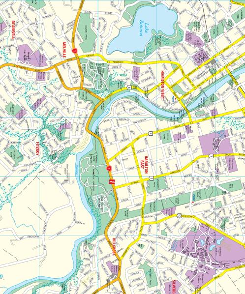
6 2 2. Site Location 2.1 Description The location of the proposed designation site is shown on Figure 1. The site is located between Horsham Downs Road and North City Road in northern Hamilton and is zoned Future Urban by the Hamilton City Council (HCC) District Plan. The site of the proposed school is currently rural. It is surrounded by rural land to the north and has the expanding residential area of Hamilton City approaching from the south. There are two existing schools located near the site, Hamilton Christian School on North City Road and Te Totara Primary School on Hector Drive. 2.2 Rototuna Structure Plan The site is within the area that is the subject of Variation 12 to the HCC District Plan and the Rototuna Structure Plan. The latest available version of the Rototuna Structure Plan is shown as Figure 2. The Rototuna Structure Plan includes a Rototuna Town Centre, residential areas, an educational precinct including the designation site and community facilities such as playing fields, a library and aquatic centre. Figure 2 shows that in the draft Structure Plan, the school site is to be served by a School Collector Road connected via a new road to North City Road. At its eastern end the School Collector Road connects at a T-intersection with Hector Drive and continues around to connect with Borman Road. The timing of the construction of the full length of the School Collector Road is dependent on other land owners and the agreements they reach with Council. The Ministry of Education has no control over these factors. The Ministry has an agreement with the relevant land owner that interim access will be available to the School site as shown on Figure 2. This interim arrangement will operate as a cul-de-sac using a section of the School Collector Road and a local road that is identified in the Structure Plan. These are both shown in Figure 2. Both the interim scenario and the long-term Structure Plan scenario are assessed in this Transportation Assessment. 2.3 Location in Road Hierarchy Figure 3 shows the location of the site in the context of the existing and planned future road hierarchy. The upper section of Figure 3 shows the road hierarchy currently set out in the District Plan. In this hierarchy the major arterial network in the Rototuna area is formed by Wairere Drive, Resolution Drive and Gordonton Road. This is supported by a minor arterial network of Thomas Road, Borman Road, Hukanui Road and Horsham Downs Road. No road network detail is included in the vicinity of the site.

7
8


9
10 6 The lower section shows the road hierarchy that was included in the draft Rototuna Structure Plan, produced by HCC in September In this hierarchy the major arterial network includes the Waikato Expressway which follows an alignment from Resolution Drive to Gordonton Road and passes along the northern boundary of the site. The structure of the arterial network remains generally the same as in the existing District Plan however Gordonton Road changes from major arterial to minor arterial status. The draft structure plan includes more detail in the vicinity of the site. Borman Road is classified as a minor arterial from Gordonton Road through to Kay Road and a network of collector roads feed off it including North City Road and Hector Drive. The school site itself is located on a proposed collector road which runs between North City Road and Hector Drive. 2.4 Location Strategy Figure 4 shows the location of existing secondary and middle schools in Hamilton. The nearest school to the proposed designation site is Hamilton Christian School. This is a co-educational private school that accommodates primary, intermediate and secondary school age students. Ministry of Education information shows that it has a roll of approximately 400 students. St Andrew s Middle School is a state school accommodating Year 7 to 10 students (Form 1 to 4). It is located approximately 4.5km from the site and has a roll of 150 students. The nearest large secondary schools are St Paul s Collegiate, a private Anglican partly coeducational secondary school with a roll of 570 students and Waikato Diocesan School for Girls, a state integrated Anglican secondary school with a roll of 640 students. These schools are both located approximately 5.5km from the site. The nearest co-educational state secondary school is Fairfield College on Bankwood Road, some 5km from the designation site. It has a roll of about 1,200 students. Figure 4 illustrates that whilst Hamilton s residential area has extended out to the north, state secondary schools are predominantly located in the central and southern areas of the city. Schools differ from most other urban activities. They are developed to meet defined demands, rather than being developed to generate new demands. New schools do not therefore generate new school traffic. Rather, new schools simply better meet the demands that already exist, or will exist as population growth occurs. This means that when considered in a strategic sense, a new school will produce a net reduction in vehicular travel by enabling an average reduction in catchment size for all schools in the vicinity. This then allows more opportunity for walk, cycle and bus trips and it reduces the average length of the school trip. A new urban school therefore, will inevitably result in benefits to the whole transportation system. What a new school will do however, is focus existing school travel to a new location. This means that when choosing a site for a new school, the following four important characteristics must be exhibited: (i) a location close to the centre of maximum demand, (as determined by existing population, forecast population and the locations of existing schools);


11
12 8 (ii) (iii) (iv) the availability of a parcel of land of sufficient size to accommodate a school; a location that is well connected to the strategic road network via arterial traffic routes to ensure an appropriately high level of vehicular and pedestrian accessibility; and a location that is well served by public transport facilities. The proposed site is within the Future Urban Zone of the District Plan and is surrounded by planned future residential growth. This combined with the existing location of schools in Hamilton and the lack of a major secondary school in the northern suburbs indicates that the designation site is located suitably at a centre of demand. Sufficient land is available and the location within a planned education precinct within the Rototuna Structure Plan maximises potential for quality pedestrian, cycle, and vehicle connections and accessibility. No public transport facilities existing at present, however these can be introduced as the area develops and the school will be designed to accommodate bus drop off and pick up on site also. Therefore, the proposed location of the designation site offers an opportunity to serve a local catchment and reduce the distance students need to travel to school. In particular, the designation may potentially reduce the need for travel on routes and bridges that are already heavily used by commuter traffic from Hamilton s northern suburbs.

13 9 3. Existing Transportation Network 3.1 Existing Road Network The site does not currently have frontage to an existing road. The nearest existing roads are North City Road, Hector Drive and Borman Road. Figure 5 is an aerial photograph of the local area showing formed roads, and existing and proposed educational facilities. North City Road is a rural road with a posted speed limit of 100km/h. It has a 7m wide sealed carriageway and sealed shoulders of varying widths. It has a short section, at its southern end near Borman Road and the access to Hamilton Christian School, which has a 50km/h posted speed limit. North City Road is shown in Photographs 1 and 2. Photograph 1 : North City Road south of Kay Road looking north. Photograph 2 : North City road, north of Borman Road looking south. The intersection of Borman Road and North City Road is controlled by Give Way signs on the North City Road approach. There are right and left turning lanes on North City Road and a right turn bay is provided on Borman Road. The carriageway of Borman Road between North City Road and Hector Drive features cycle lanes on both sides of the road, one traffic lane in each direction, a painted central median and indented parking and bus bays at various points along its length. Borman Road is shown in Photographs 3 and 4.


14 Hamilton Christian School North City High School NOR Surrounding Area 5NTS SCALE: G:\TDG\Jobs\ \ \10574\Drawings\10574-T2A FIG 5.dwg Tuesday, 20 April 2010 Resolution Drive Borman Road Horsham Downs Road Borman Road Hector Drive North City Road Designation Site Te Totara Primary


15 11 Photograph 3: Borman Road looking west towards North City Road Photograph 4: Borman Road looking east Hector Drive currently operates as a cul-de-sac that provides access to Te Totara Primary School. The intersection of Hector Drive and Borman Road is controlled by Give-Way signs on Hector Drive. At present, Borman Road terminates west of this intersection. HCC advise that Hector Drive has been specifically designed to serve the needs of Te Totara Primary School and ultimately other educational, recreational and residential land uses in the area. It features a 7.0m wide carriageway with 2.0m wide paved parking bays on the western (school) side. The footpath on the school side is 3.0m wide. This 3.0m wide path begins at a signalised pedestrian crossing on Borman Road and leads to the Te Totara entrance. The footpath on the eastern side of Hector Drive is 2.0m wide. There is a signalised pedestrian crossing on Hector Drive however as Hector Drive currently terminates with a turning head north of the Te Totara entrance, these signals are not currently active. Hector Drive is shown in Photographs 5 and 6. Photograph 5: Hector Drive, looking north towards Te Totara Photograph 6: Borman Road looking south towards Te Totara


16 Existing Walking and Cycling Networks The existing walking and cycling infrastructure that is provided in the area surrounding the site includes a mixture of on-road cycle lanes, off-road cycle and pedestrians paths immediately adjacent to road alignments, and off-road paths through parks and along waterways. On the arterial network, there is an off-road shared walking and cycle path along Wairere Drive and Resolution Drive and the series of grade-separated underpasses at major roundabouts. Walking and cycling infrastructure is also a dominant feature of the recently completed Resolution Drive/Borman Road roundabout. Some examples are shown in Photographs 7 to 10 below. Photograph 7: Off-Road path to Resolution Drive underpass Photograph 8: Borman Road Underpass Photograph 9: Off-Road path to Resolution Drive underpass Photograph 10: Standard and off-road footpath, Borman Road The roundabout construction included off-road paths, with landscaping, seating and lighting, leading to underpasses under Borman Road and Resolution Drive. These facilities are typical of those that are provided at the Wairere Drive/Hukanui Road, Wairere Drive/Resolution Drive and Wairere Drive/River Road roundabouts. Locally, the Borman Road carriageway includes footpaths and on-road cycle lanes. There are signalised pedestrian crossings on Borman Road and Hector Drive and Hector Drive features 2-3m wide footpaths. Examples of existing cycle and pedestrian facilities on Borman Road are shown in Photographs 11 and 12.


17 13 Photograph 11: Borman Road carriageway, looking towards North City Road Photograph 12: Borman Road signalised pedestrian crossing 3.3 Public Transport Services There are currently three public transport routes in the vicinity of the site. The 30 Northerner service runs from Westfield Chartwell through Huntington, Rototuna and St James passing along Resolution Drive and Farringdon Drive. This service operates Monday to Saturday approximately every 30 minutes during peak periods and hourly during off-peak. The RD Rototuna Direct Service runs half hourly during weekday peak times only from the Transport Centre in Bryce Street to Thomas Road along Heaphy Terrace, via Westfield Chartwell and Hukanui Road. The 16 Rototuna Service follows a similar route but stops more frequently and runs half hourly on weekdays and hourly at weekends.
18 14 4. Existing Traffic Volumes HCC holds limited information about traffic volumes in the vicinity of the site. The site does not currently have access to an existing road and much of the existing network around the site is not yet fully completed and connected. Therefore the focus of this assessment will instead be the planned future network and the expected traffic volumes on that network.
19 15 5. Road Safety The site does not have frontage to an existing road however a search of the road safety history of the local area has been made using the New Zealand Transport Agency (NZTA) Crash Analysis System (CAS). The search has included Borman Road from the Resolution Drive roundabout to Hector Drive, the section of North City Road from Borman Road to just beyond the access to Hamilton Christian School and the full length of Hector Drive. The search included the most recent full five year period from 2005 to 2009 inclusive and the available data from It revealed one non-injury crash that occurred on North City Road during It involved a truck hitting the rear of a northbound car that was waiting to turn right into a private access. This road safety history does not show any underlying safety issues in the wider area, however much of the surrounding network has only recently been constructed and the local road network that will serve the designation site is yet to be designed or built. In planning the concept design for the proposed school consideration has been given to how traffic demands can be accommodated in a manner that optimises the safety of the interface between the site and its frontage road. As will be explained later in this report, consideration has also been given to the form of the frontage road in providing for the peak flow demands of the proposed school in a safe and efficient manner.
20 16 6. Future Traffic Volumes To assist with this assessment, HCC has made available modelled traffic volumes from the Waikato Regional Transportation Model (WRTM). These model results reflect the latest available forecasts for traffic volumes on the network surrounding the site at the year It is understood that the land use in the model does not reflect the school proposal. The modelled daily traffic volumes are shown on Figure 6 below. Figure 6 : Modelled Daily Traffic Volumes, 2021 Figure 6 shows that the School Collector Road carries a two-way volume of 2,635 vehicles per day (vpd) at its western end and 1,089vpd at its eastern end. North City Road is modelled as carrying 3,288vpd north of Borman Road whilst Borman Road carries 2,442vpd east of North City Road and 2,752 east of the School Collector Road. The morning and evening peak hour volumes (two-hour flows) are presented on Figure 7 and Figure 8 respectively.
21 17 Figure 7 : Modelled Morning Peak Traffic Volumes (Two-Hours), 2021 Figure 8 : Modelled Morning Peak Traffic Volumes (Two-Hours), 2021
22 18 7. School Concept Plan 7.1 Proposed Layout Concept The proposed concept plan for the school is shown in Figure 9. The plan shows the indicative layout of school buildings including classrooms, a hall, a gym and an administration building as well as hard courts and playing fields. The transportation features of the concept plan include: a staff parking area. an on-site bus and light vehicle drop-off/pick-up area with one entry-only and one exit-only access, located approximately 100m apart. a student parking area with a separate access located approximately 100m from the dropoff/pick-up exit. a potential location for a pedestrian underpass near the HCC drainage reserve. a potential location for a signalised pedestrian crossing. Noise bunds are proposed on the boundary between the school and the proposed Waikato Expressway alignment. 7.2 Proposed Student and Staff Numbers The assessment of traffic effects of the designation is based on the maximum enrolments presented in Table 1. LEVEL AGE ROLL Year Year Year Year Year Year Year Total - 2,500 Table 1 : Proposed School Roll by Level and Age The proposed school will have a maximum of 2,500 students when it reaches capacity. An estimate of 150 teaching and support staff would be required when this enrolment level is achieved. The MOE advises that the school is likely to be staged and is planned to open in 2013/14 with a role of 650 students. It is then expected that capacity would be increased to 1,110 students by 2016, 1,600 students by 2018 and the full 2,500 students by 2021.
23
24 Access and Egress Three vehicle accesses are proposed to the School Collector Road. These are an entry to the on-site drop-off/pick-up area, an exit from this area and a separate two-way access to the student parking area. The staff car park is accessed from the drop-off/pick-up area however the student car park has been provided with a separate access. Staff are expected to generally arrive at the school before the peak period of drop-off activity during the morning and depart after the peak period of pick-up activity in the afternoon. The peak period of student vehicles however is expected to coincide with drop-off/pick-up activity and therefore the student car park has been provided with a separate access to ensure their vehicles are not interacting with vehicles and students in the drop-off/pick-up area. The drop-off/pick-up area is able to be designed to accommodate circulation and parking of buses and light vehicles and to facilitate movement of students boarding and alighting from these vehicles within the land area that has been set aside. 7.4 School Collector Road Design The detailed design of the School Collector Road cross-section and the on-site drop-off/pick-up area can be developed when consent is sought to build the school. It is envisaged that the School Collector Road cross-section would be similar to the existing cross-section on Borman Road, shown previously in Photographs 3 and 4. This would reinforce the character of the area as an education precinct including nearby Te Totara Primary School and Hamilton Christian School. Features that could potentially be used in the cross-section to reinforce the presence of an education precinct include: Narrow traffic lanes; On-road cycle lanes; Wide footpaths; Threshold treatments to define the start and end of a school area; Roadside parallel parking bays; and Signalised and/or unsignalised pedestrian crossing facilities including central refuge islands. Many of these features have already been used on both Borman Road and Hector Drive adjacent to Te Totara Primary School. Right turn bays within a central median are likely to be required at the entrance to the drop-off pick up area and potentially the student car parking area, once the School Collector Road is connected to Hector Drive and/or Borman Road at its eastern end. Interim arrangements are discussed in the next section. During detailed design stages of the project, consideration can be given to integration with the HCC recreation area proposed on the southern side of the School Collector Road.
25 Interim Arrangement As indicated on Figure 2, the school will be served by an interim cul-de-sac arrangement until the School Collector Road is completed and connected at both ends. It is envisaged that the section of the School Collector Road that is built for the opening of the School would be built to its final intended standard incorporating the features described above. The School Collector Road would initially terminate east of the student car park access. The section of local road that will provide interim access to the school will be designed and constructed to a standard suitable to carry the construction traffic associated with the school. Once the school is open this road would carry all the operational traffic generated by the school, up to an identified threshold in the school roll. This threshold is discussed further in Section 9 of this report. The interim connection will revert to local road status once the School Collector Road is completed and connected.
26 22 8. Traffic Generation 8.1 Traffic Generation Considerations When considering traffic that is generated by a school, it should be kept in mind that a school is different in concept to other activities that might generate traffic. This is because a school satisfies a defined demand for travel. The number or locations of schools does not affect the need for students to travel to school. In other words, creating a new school does not generate new traffic that does not already exist on the road network. Rather, new schools simply have the effect of better providing for demands that already exist, and are being satisfied in a less efficient manner by other schools elsewhere. In this regard then, the development of new schools must result in a more efficient transportation system when the system as a whole is considered. The presence of a new school that serves a local catchment inevitably results in overall reductions in both vehicular trip numbers and trip lengths. This is considered particularly relevant in Hamilton where residential growth has been occurring in the north of the city whilst secondary schools are predominantly located in central and southern Hamilton. The location of existing secondary schools and middle schools in Hamilton was shown previously on Figure 4. What a new school does do however, is concentrate school traffic movements to a point. This is one of the primary reasons that it is desirable to locate a school adjacent to one or more arterial roads, so that the school traffic is not concentrated into a residential neighbourhood; and so that there is minimal diversion of traffic away from routes that would already otherwise be used by school traffic. The traffic generating patterns of schools are dependent on a number of factors, including: the type of school; the number of driving aged students, and the extent to which parking is available for those students; the nature of the school catchment, and hence the extent to which students can walk, cycle or bus to school; the availability of bus services for the school, both in terms of regularly scheduled services that pass close to the school, and chartered school bus services; and the proximity of the school to city-bound arterial routes that enable parent drop-offs and pick-ups as part of existing home-to-work and work-to-home trips. To establish the likely traffic generation patterns of the proposed school, reference has been made to the report School Travel Behaviour in New Zealand prepared for the New Zealand Transport Agency in This report uses Ministry of Transport (MOT) Household Travel Survey (HTS) from 2003 to 2006 to formulate equations for estimating school traffic generation based on the type of school, its location, roll size and age of students. 8.2 School Traffic Generation Daily Traffic Generation The NZTA report treats intermediate (age 11-12) and secondary (age 13-17) schools separately. Intermediate schools in major urban areas generate 1.15 trip legs per student (one-way).
27 23 Therefore the 760 students will generate a total of 1,748 trip legs (two-way) over the course of a full day. For secondary schools in major urban areas, the rate is 1.12 trip legs per student (one-way) therefore the total daily generation of the 1,740 students is 3,897 trip legs (two-way). The expected traffic generation of the proposed school, split into the walking and cycling, public transport, vehicle passenger and vehicle driver modes is summarised in Table 2. MODE OF TRAVEL YEARS 7 AND 8 YEARS 9 TO 13 % of total vpd (IN+OUT) % of total vpd (IN+OUT) TOTAL (vpd (IN+OUT)) Walk/Bike 45% % 1,511 2,298 Bus 11% % Vehicle Passenger 44% % 1,551 2,320 Vehicle Driver 0% 0 8% Total 100% 1, % 3,897 5,645 Table 2 : Daily Traffic Generation, Students by Mode The table shows the student roll is expected to generate a total of 2,638vpd as either private car drivers or private car passengers. The NZTA report recommends that staff are assessed as travelling to the site in single-occupancy vehicles. Therefore for the 150 staff an allowance of 300vpd is made. The report also recommends that an allowance of 1% of total daily flow is made for service vehicles such as plumbers and tradesmen. Table 2 shows that 709 student trips are made each day by bus. As the roading network in the vicinity of the site is not yet built, there are no public transport services in the vicinity of the site. However, as the area grows, it is likely these will be added. Model split survey data from Traffic Design Group surveys at schools in Auckland showed that 40% of students who travelled by bus used public services and 60% used dedicated school buses. This proportion has been adopted for this assessment. It is however acknowledged that the split is site-specific and will depend on the student catchment and the various services that are available. The adopted proportion can be updated in subsequent assessment stages as more information becomes available. Using an average occupancy of 20 students per bus, 22 buses would be required to deliver the students to the school. These buses make two movements, one entry and one exit, for each drop-off and pick-up therefore the expected bus volume in each peak period is 22vph (IN+OUT) and the total volume over the day is 44vph (IN+OUT). The total daily traffic generation of the proposed school is summarised in Table 3.
28 24 Vehicle Type Student Passengers VPD (IN+OUT) 2,320 Student Drivers 318 Staff 300 Servicing 29 Buses 44 Total 3,011 Table 3 : Daily Traffic Flows The table shows that will the full roll of 2,500 students the school is expected to generate 3,011vpd (IN+OUT). This is expected to occur at the year The staging of the school s capacity for students and the associated traffic generation is illustrated in Figure 10. Figure 10 : Staged Traffic Generation Estimates With the opening roll of 650 students, the estimated daily traffic generation is 783vpd, increasing in three steps to the full 3,011vpd by Hourly Traffic Generation The NZTA report also provides profile information for the distribution of the daily vehicle activity during the peak hours of activity. For all types of school the morning peak hour is the hour ending 9:00am and the afternoon peak hour is the hour ending 4:00pm. For Year 7 and Year 8 schools, 48% of the daily traffic flows occur during the morning peak and 33% occur during the afternoon peak. For Year 9 to 13 schools 43% of activity occurs during the morning peak hour and 25% during the evening peak hour.
29 25 Applying these factors to the estimated daily flows above determines that the expected morning peak hour traffic generation of the proposed school is 1,339vph (IN+OUT) whilst the afternoon peak hour volume is 823vph (IN+OUT). 8.3 Future Public Transport Services Table 2 shows that when the school reaches its maximum roll of 2,500 students, some 709 bustrips are expected each day. This is equivalent to some 355 students travelling by bus, making one arrival and one departure trip. For the purpose of undertaking a capacity analysis of the site driveways a split of 60/40 between dedicated school buses and public services has been adopted. This is based on an assumption that Environment Waikato will be operating some bus services in the Rototuna area as it grows and develops and some students will use these services. The remainder would use dedicated school bus services administered by the Ministry. It is unlikely that any public transport services will be in place when the school opens and further unlikely that any would be routed onto the School Collector Road while it is in cul-de-sac form. In the longer term however, public transport services could travel along the School Collector Road. This is a matter for Environment Waikato s public transport planning team and the school is by no means reliant on such services being provided. A letter has been provided to Environment Waikato informing them of the key aspects of the school proposal including the expected roll and proportion of students using bus transport, either public or otherwise. Consultation with EW can continue as the project progresses. When consent is sought to design the school, a detailed analysis of likely bus movements to and from the site will be undertaken as part of the design of the drop-off and pick-up area.
30 26 9. Traffic Distribution and Assignment The peak hours of traffic generating activity at the school are of interest in assessing the ability of the surrounding transportation network to accommodate generated traffic. The likely distribution of traffic movements on the network will on the form of this network and how the land use around the school and in the wider Rototuna area develops. As there is uncertainty about this, the assessment of transport effects on the surrounding network has been undertaken on the basis that all movements to the school come to and from the south, and they are split equally between the east and west. Combining this estimation with the known split of inbound and outbound movements from the combination of student driver, staff and drop-off/pick-up activity gives an estimate of the traffic generated by the school on the local network. The generated movements are summarised on Figure 11. These movements have been used to undertake a high level assessment of the ability of the surrounding road network to accommodate the proposed school.
31
32 Transportation Network Effects 10.1 Methodology Typically, assessing the transportation network effects of the proposed school designation would involve adding the generated traffic movements to the existing traffic volumes on the surrounding road network and assessing its ability to accommodate the combined traffic volumes. In this case, the transportation network surrounding the site is the subject of a draft structure plan. Some traffic modelling has been undertaken using this draft network as part of other HCC projects. However care has been taken when using this modelling as the exact network form and the full extent of land use in the area are not necessarily established. For the purpose of this NOR, an assessment has been made of the ability of the most likely future transportation network to accommodate the school-generated traffic. Reference has been made to the Waikato Regional Transportation Model (WRTM) forecasts at the year However, as these flows do no necessarily include all applicable land use, reference has also been made to typical flows for roads with the same classification in Hamilton. Care is also required however to avoid the potential for double counting of the traffic generated by the school, when this is overlaid on an area model that already predicts some traffic generation for the land to be occupied by the school. This ultimate scenario represents the long-term situation where the school, Rototuna Structure Plan and the associated road network are all fully developed and implemented. An interim scenario has also been assessed where the school is accessed from a purpose-built access road that connects to North City Road. This scenario has been assessed to ensure that if for any reason the roading elements of the Rototuna Structure Plan are delayed or not in place, there is an option to access the school from the existing road network. This interim scenario includes the fully developed school. Although the school will be staged, the analysis aims to confirm that an interim roading arrangement can accommodate the demands of the fully developed school if necessary. This scenario is considered highly unlikely however because the ultimate school roll will only be reached as the area around the school, and the associated roading, is developed. Overall the purpose of both these assessments is to provide a strategic analysis that demonstrates that the school designation can be accommodated by the surrounding network. Characteristics such as school traffic distribution and assignment, background traffic volumes and detailed intersection layouts and operation can all be refined when consent is sought to build the school. This NOR assessment focuses on the following key elements of the road network. The proposed school driveways on the School Collector Road; The School Collector/Collector intersection to the west; and The School Collector/Borman Road intersection to the east Absorption Capacity (Austroads) Figure 12 shows a graph developed using the Austroads Guide to Traffic Engineering Practice, Part 5: Intersections at Grade. This graph shows practical absorption capacity, which is the
33 29 ability of a major road stream of traffic to accommodate or absorb a minor stream of traffic flow, from a side road. It is based on the residual capacity in the major road flow and the gap acceptance requirements of the minor road flow. For minor road vehicles turning left onto a twolane, two-way major road the Austroads recommended minimum gap and follow up headway are 5 seconds and 2 to 3 seconds respectively. For right turns on a two-lane, two-way major road the minimum gap and follow-up headway are 5 seconds and 3 seconds respectively. For the purpose of a simple analysis, values of 5 seconds and 3 seconds have been adopted for minimum gap and follow-up headway respectively, for all minor road vehicles. Figure 12 shows the practical absorption capacity (vehicles per hour) for increasing volumes of major road flow. Practical Absorption Capacity - Unsignalised Intersections (From Austroads Part 5) 1, Minimum Gap (t a) = 5s Follow-up Headway (t f) = 3s) C p - Practical Absorption Capacity (vph) ,000 1,200 1,400 1,600 1,800 2,000 Q p - Major Road Flow (vph) Figure 12: Practical Absorption Capacity The area above the line can be considered to represent combinations of major and minor road traffic volumes that exceed the capacity of unsignalised intersections. Combinations below the line are operating within the capacity of an unsignalised intersection Ultimate Scenario School Driveway Intersections The School Collector Road is included in the latest WRTM modelling provided by HCC. The daily and peak hour modelled volumes are presented in Table 4.
34 30 LOCATION DAILY (vpd) AM PEAK (vph) PM PEAK (vph) School Collector Road, Western End 2, School Collector Road, Middle Section 1, School Collector Road, Eastern End 1, Table 4 : Modelled School Collector Road Volumes Table 4 shows that in the middle section, adjacent to the designation site, the School Collector Road carries a maximum peak hour volume of 175vph. The school access with the highest volume is the exit-only access from the drop-off/pick-up area. The exiting volume is 576vph and 348vph during the morning and afternoon peak hours respectively. Figure 13 shows these values plotted on the absorption capacity graph. 1,000 Practical Absorption Capacity - Unsignalised Intersections (From Austroads Part 5) C p - Practical Absorption Capacity (vph) C p = 576 vph C p = 348 vph Minimum Gap (t a ) = 5s Follow-up Headway (t f ) = 3s ,000 1,200 1,400 1,600 1,800 2,000 Q p - Major Road Flow (vph) Figure 13: School Driveway Analysis The graph illustrates that at the WRTM predicted flow of 175vph on the major road (x-axis), a flow of up to 830vph could be absorbed from a minor road. Therefore if the WRTM was an accurate indication of the likely non-school traffic volume on the School Collector Road, the school driveways involving up to 576vph will operate efficiently and well within capacity. It is also of interest what the limiting major road volume would be, knowing the expected minor road volume from the school. During the morning, the exit volume from the school is 576vph. The graph illustrates that this could be absorbed into a major road volume of up to around 520vpd. The forecast major road volume is however only about 175vph. Typically, on collector roads the peak hours of activity account for around 10% of the daily traffic volume. Therefore, the school driveways would have sufficient capacity even if the opposing traffic volume increased to around 5,200vpd (520vph x 10).
35 31 By comparison, the HCC Development Manual indicates that a Collector Road carries a traffic volume of up to 3,000vpd. The latest traffic count from another collector road in a fully developed area of Rototuna/Flagstaff, Discovery Drive, indicates that it carries a daily volume of around 4,760vpd including morning and evening peak hour volumes of 500vph. Therefore the proposed school driveways can be expected to have sufficient capacity on a typical Collector Road Collector-Collector Intersection, Western End In the draft Rototuna Structure Plan the School Collector Road is shown as connecting to another Collector Road at its western end. In the WRTM, this intersection is Give-Way controlled. This Collector Road is modelled in the WRTM as having a daily volume of 2,500vpd south of the School Collector Road and 1,500vpd north of the School Collector Road. During the morning peak hour, the modelled volume that is opposing the School Collector Road traffic (including vehicles turning right into the School Collector road) is 84vph during the morning peak and 224vph during the afternoon peak. The modelled exiting flow on the School Collector Road in the WRTM is 155vph during the morning and 76vph. Figure 14 shows the before and after points for the morning and afternoon peak hours plotted on the absorption capacity graph. It is noted that the afternoon peak of the school is 3:00-4:00pm whereas the typical peak for other traffic on the network is between 4:00pm and 6:00pm. Conservatively, these peak periods have been added together, however in reality they may not coincide exactly. 1,000 Practical Absorption Capacity - Unsignalised Intersections (From Austroads Part 5) C p - Practical Absorption Capacity (vph) Major = 84 Minor = 155 Major = 467 Minor = 443 Major = 383 Minor = 330 Minimum Gap (t a) = 5s Follow-up Headway (t f) = 3s) AM (WRTM 2021) AM with School PM (WRTM 2021) PM with School 100 Major = 224 Minor = ,000 1,200 1,400 1,600 1,800 2,000 Q p - Major Road Flow (vph) Figure 14: Practical Absorption Capacity, Collector-Collector Intersection
36 32 As Figure 14 illustrates, the presence of the school adds some traffic volume to both the major and minor arms of the intersection. During both peak hours, the combinations of traffic volumes remain below the practical absorption capacity line, meaning a Give-Way controlled intersection can accommodate the expected traffic volumes. This capacity analysis does not specifically account for the fact that at this intersection, the traffic associated with the school is likely to be turning right into the School Collector Road and left out of the School Collector Road. Conservatively, these right turn movements have been added to the major road flow however in reality they do not oppose the left turn movement out. As such, this analysis is again conservative and robust for this stage of the assessment. Overall Figure 14 shows that Give-Way controlled intersection is expected to have sufficient capacity to accommodate the traffic designated by the school. Furthermore there is some spare capacity, should the traffic volume on the Collector Road increase beyond what the WRTM 2021 scenario has allowed for Borman Road-School Collector Road Intersection In the WRTM modelling Borman Road has a daily volume of 1,655vpd west of, and 2,744vpd east of, the School Collector Road. Figure 15 shows the before and after points for the morning and afternoon peak hours at this intersection, plotted on the absorption capacity graph. 1,000 Practical Absorption Capacity - Unsignalised Intersections (From Austroads Part 5) C p - Practical Absorption Capacity (vph) Major = 184 Minor = 82 Major = 567 Minor = 370 Major = 386 Minor = 281 Minimum Gap (t a) = 5s Follow-up Headway (t f) = 3s) AM (WRTM 2021) AM with School PM (WRTM 2021) PM with School 100 Major = 227 Minor = ,000 1,200 1,400 1,600 1,800 2,000 Q p - Major Road Flow (vph) Figure 15: Practical Absorption Capacity, School Collector-Borman Road Intersection Figure 15 shows that the traffic volumes expected to be generated by the school can be accommodated by a Give-Way controlled intersection. The maximum minor road volume occurs during the morning peak when some 364vph is exiting the School Collector Road. The modelled major road flow is 567vph at this point, which lies under the capacity line.
37 33 The graph shows that the major road flow could increase to up to around 950vph before capacity of the intersection is reached. Peak hour volumes of this level are generally similar to what occurs on Thomas Road, which is a nearby example of a minor arterial that has fully developed surrounding land use including a major shopping centre Interim Scenario Initially it is proposed that the school site will be served by a cul-de-sac arrangement using a section of local road and a section of the School Collector Road. This was illustrated on Figure 2. There are currently many unknowns surrounding the timing of development of land and roading in the area covered by the Rototuna Structure Plan. There is also some uncertainty about the rate at which the school roll will grow and this is dependent on factors such as residential development in the surrounding area and the popularity of the new school relative to others in the area. An assessment has therefore been made to determine when the interim school access arrangement would have to be upgraded to the full School Collector Road, with connections at both ends. The main limiting factor in identifying this threshold is considered to be the ability of the intersections of the local road/north City Road and North City Road/Borman Road to accommodate the peak hour turning movements associated with the school. The threshold that has been identified is a volume of 1,980vpd which correlates to a roll of 1,650 students. By comparison, the HCC Development Manual suggests that local roads carry 800-1,000vpd and collector roads carry 1,000 to 3,000vpd. The draft New Zealand Standard for Land Development and Subdivision Engineering (NZS 4404) recommends that local roads can carry up to 2,000vpd. The proposed interim local road connection will be designed to carry construction traffic and therefore will be of a higher standard than a typical local road. A maximum volume of 1,980vpd sits within the various recommended ranges for local and collector roads and is considered to be an appropriate upper limit for the interim arrangement. If other residential development occurs along the local road connection the threshold number of students at the school would decrease. Appendix 1 contains a table with various combinations of students and households which in total equate to the threshold of 1,980vpd. It is also noted that when the local road connection ceases to be used as a route to the school, some physical measures may be required to deter traffic from using it. These measures could include traffic calming along the road or threshold treatments at either end Transportation Network Effects Summary The analysis demonstrates that the traffic generated by the school can be accommodated on the planned future road network in the area. The form of this network and the likely traffic volumes on it are the subject of ongoing work by HCC through projects such as the Rototuna Structure Plan. An assessment has been made using the best available information and this assessment shows that the year 2021, with the fully developed school, priority-controlled intersections are able to
38 34 provide sufficient capacity for the school driveways and the intersections at either end of the proposed School Collector Road. More information will emerge as the North City High School project moves towards design and construction and more detailed assessment of intersection performance can be undertaken. Any required mitigation can be incorporated at design and resource consent stages, and the assessments clearly show there is ample capacity within the network to accommodate the design demands likely to arise. Experience and observations large secondary schools in Hamilton suggest that whilst there can be some congestion effects associated with before and after-school peaks, these are generally of short duration and can be minimised through good design of drop off and pick up areas in particular. In this case, both the on-site provisions and the local road network can be designed specifically to be consistent with an education precinct. Therefore it is expected that the generated traffic volumes will be able to be accommodated on the transportation network as it develops. Further supporting this is the existing distribution of high schools in Hamilton and the lack of a secondary school serving the northern suburbs. North City High School has the potential to significantly reduce the distance students are required to travel to school. With these reduced distances come enhanced opportunities for walking and cycling trips and in a transportation network sense, less demand for travel on already heavily used routes from northern Hamilton into the central city for example. There are therefore net positive effects to be derived elsewhere on the network.
39 District Plan Assessment 11.1 Policies and Objectives The proposed designation would be zoned Community Facilities by the District Plan. Section 5.3 of the District Plan addresses Community Facilities. They are described as an essential component in the urban environment and contribute significantly to the community s quality of life. The principal issues regarding community facilities in Hamilton are: The scale and intensity of community facilities can impact on neighbourhood character and amenity values; The operation of community facilities can generate a range of negative effects that impact on the neighbourhood amenity values; Community facilities and their siting in relation to the transport network can have adverse traffic effects; Community facilities are needed in new growth areas but there are constraints on accommodating them. These objectives and an assessment of the proposed designation against each policy are presented below. Objective Community Facilities To facilitate the provision of a range of community services and facilities throughout the city, in a manner which minimises adverse environmental effects. Policies a) Ensure that the scale, form and nature of those community services and facilities operating throughout residential areas is compatible with local amenity values and that adverse impacts on neighbours are avoided. The proposed school is being planned as part of the Rototuna Structure Plan. The Structure Planning process gives the opportunity for HCC to plan land use and transportation networks around the school to maintain local amenity values and minimise adverse effects on neighbours. The school designation site is bordered to the north by the proposed Waikato Expressway alignment. Noise and visual effects mitigation measures will be developed as part of the school s planning and design to ensure the designation does not create adverse effects for the Expressway project and vice versa. Other neighbouring and nearby land uses include schools, recreational fields and residential housing. The development of a school in a future urban area allows vehicle, pedestrian and cycle connections to be designed and purpose-built to minimise any adverse transportation effects and maintain amenity values. b) Enable the development and operation of a range of community facilities on sites in residential areas including new growth areas where impacts on neighbourhood amenity values and on traffic safety and efficiency can be avoided or mitigated. As described above, the proposed school designation is in an identified growth area where the surrounding transportation network can be specifically designed to accommodate generated traffic while maintaining amenity, safety and efficiency.
Ministry of Education Flat Bush School Notice of Requirement. Integrated Transportation Assessment Report. February 2016
 Ministry of Education Flat Bush School Notice of Requirement Integrated Transportation Assessment Report February 2016 TDG Ref: 12988-2 151105 ita flat bush.docx Ministry of Education Flat Bush School
Transport Assessment. Curtis Street Plan Change
 Transport Assessment Curtis Street Plan Change Transport Assessment for Curtis Street Plan Change i Contents 1. Introduction... 1 2. Existing Conditions... 2 2.1 Location... 2 2.2 Study Area... 3 2.3
EXECUTIVE SUMMARY Callan Park accommodates travel from a wide range of transport modes, including walking, cycling, bus and light rail.
 TRANSPORT AND ACCESS EXECUTIVE SUMMARY Callan Park accommodates travel from a wide range of transport modes, including walking, cycling, bus and light rail. Whilst there are some walking facilities within
1 VicRoads Access Management Policies May 2006 Ver VicRoads Access Management Policies May 2006 Version 1.02
 1 VicRoads Access Management Policies May 2006 Ver 1.02 VicRoads Access Management Policies May 2006 Version 1.02 2 VicRoads Access Management Policies May 2006 Ver 1.02 FOREWORD FOR ACCESS MANAGEMENT
Harriet Fraser Traffic Engineering & Transportation Planning
 Appendix 5: Traffic Assessment 71 26 February 2015 Mr James Beban Senior Resource Consents Planner Cuttriss Consultants Ltd PO Box 30429 Lower Hutt PO Box 40170 Upper Hutt 5140 P 04 526 2979 M 027 668
PROPOSED RESIDENTIAL SUBDIVISION
 PROPOSED RESIDENTIAL SUBDIVISION PART OF TARNEIT ROAD & 1121 DOHERTYS ROAD, TARNEIT Prepared For: TCG (RM) Developments Pty Ltd MARCH 2014 OUR REF: 16740R#1 PROPOSED RESIDENTIAL SUBDIVISION PART OF TARNEIT
Recommended Roadway Plan Section 2 - Land Development and Roadway Access
 Recommended Roadway Plan Section 2 - Land Development and Roadway Access SECTION 2 Land Development and Roadway Access 2.1 Land Use and Access Management The Federal Highway Administration (FHWA) defines
Shotover Country. Proposed Private Plan Change. Transportation Assessment Report. February 2010
 Shotover Country Proposed Private Plan Change February 2010 PO Box 13 835, Armagh Christchurch 8141 P: +64 3 379 2404 www.tdg.co.nz New Zealand Shotover Country Proposed Private Plan Change Quality Assurance
1.5 On this basis it is fundamental that the Transport Strategy for the site focuses on the following key criteria,
 1.0 Introduction 1.1 The Transport Assessment has been prepared on behalf of Eon and Roger Bullivant Ltd in respect of the proposed mixed use sustainable urban extension of Drakelow Park. 1.2 The methodology
Traffic Impact Study. Westlake Elementary School Westlake, Ohio. TMS Engineers, Inc. June 5, 2017
 TMS Engineers, Inc. Traffic Impact Study Westlake Elementary School Westlake, Ohio June 5, 2017 Prepared for: Westlake City Schools - Board of Education 27200 Hilliard Boulevard Westlake, OH 44145 TRAFFIC
A5.1 Permitted activities
 Section A5 Transportation A5.1 Permitted activities A5.1.1 Activities within roads Note: Refer to Section D for the definition of road (a) Any activity associated with the movement of traffic and the functioning
Kings College, Otahuhu Proposed Plan Change. Integrated Transportation Assessment Report
 Proposed Plan Change Integrated Transportation Assessment Report 23 October 2017 Project: Report title: Document reference: Kings College, Otahuhu Integrated Transportation Assessment Report J00700 Kings
Corporate. Report COUNCIL DATE: June 26, 2006 NO: C012 COUNCIL-IN-COMMITTEE. TO: Mayor & Council DATE: June 22, 2006
 Corporate NO: C012 Report COUNCIL DATE: June 26, 2006 COUNCIL-IN-COMMITTEE TO: Mayor & Council DATE: June 22, 2006 FROM: General Manager, Engineering FILE: 0410-20(MoT/Gate) SUBJECT: Surrey Response on
Response to further information request Ministry of Education Notice of Requirement (200 & 252 Park Estate Road)
") 21 Pitt Street PO Box 6345, Auckland 1141, New Zealand T: +64 9 300 9000 // F: +64 9 300 9300 E: info@beca.com // www.beca.com Auckland Council Private Bag 92300 Victoria Street West Auckland 1142 15 August
21 Pitt Street PO Box 6345, Auckland 1141, New Zealand T: +64 9 300 9000 // F: +64 9 300 9300 E: info@beca.com // www.beca.com Auckland Council Private Bag 92300 Victoria Street West Auckland 1142 15 August
Classification Criteria
 SCHEDULE D TO RECOMMENDED OFFICIAL PLAN AMENDMENT NO. 40 SCHEDULE C-4 Road Criteria Criteria Traffic Service Objective Land Service/Access Typical Daily Traffic Volume Flow characteristics Travel Speed
North West Non-Technical Summary of the Transport Assessment September 2011
 North West Non-Technical Summary of the Transport Assessment September 2011 Introduction This is a Non-Technical Summary of the findings of the Transport assessment work undertaken for the proposed North
Statement of Evidence of Judith Makinson
 In the Matter of: The Resource Management Act 1991 and In the Matter of: Podium Sports Lodge, 18 20 Peake Road Application By: Brian Perry Charitable Trust Statement of Evidence of Judith Makinson TDG
City of Wayzata Comprehensive Plan 2030 Transportation Chapter: Appendix A
 A1. Functional Classification Table A-1 illustrates the Metropolitan Council s detailed criteria established for the functional classification of roadways within the Twin Cities Metropolitan Area. Table
6. BREENS/GARDINERS/HAREWOOD INTERSECTION - SAFETY IMPROVEMENT PROJECT
 6. BREENS/GARDINERS/HAREWOOD INTERSECTION - SAFETY IMPROVEMENT PROJECT General Manager responsible: Officer responsible: Author: Jane Parfitt General Manager City Environment DDI 941 8656 Michael Aitken
PAEKĀKĀRIKI HILL ROAD / BEACH ROAD / SH1 INTERSECTION PROGRESS REPORT
 Chairperson and Committee Members ENVIRONMENT AND COMMUNITY DEVELOPMENT COMMITTEE 6 DECEMBER 2011 Meeting Status: Public Purpose of Report: For Decision PAEKĀKĀRIKI HILL ROAD / BEACH ROAD / SH1 INTERSECTION
Woodward Hill Elementary School School Safety and Operation Review
 Address: 6082-142 nd Street Surrey, BC, V3X 1C1 Site Visit: March 7, 2011 Principal Anne Mackie Report Date: November 25, 2011 Phone: (604) 594-2408 Email: Mackie_A@sd36.bc.ca The following report is one
CHAPTER 7 ACCESS MANAGEMENT. Background. Principles of Access Management. Hennepin County Transportation Systems Plan (HC-TSP)
") CHAPTER 7 ACCESS MANAGEMENT Background Principles of Access Management Hennepin County Transportation Systems Plan (HC-TSP) Chapter 7 Access Management 7.1 Background Access management has become an important
CHAPTER 7 ACCESS MANAGEMENT Background Principles of Access Management Hennepin County Transportation Systems Plan (HC-TSP) Chapter 7 Access Management 7.1 Background Access management has become an important
March Maidstone Integrated Transport Strategy Boxley Parish Council Briefing Note. Context. Author: Parish Clerk 2 March 2016
 Context. Author: Parish Clerk 2 The Draft Integrated Transport Policy (DITS) sets out a vision and objectives, and identifies a detailed programme of interventions to support the Maidstone Borough Local
APPENDIX H EXISTING TRAFFIC CONDITIONS ANALYSIS
 APPENDIX H EXISTING TRAFFIC CONDITIONS ANALYSIS MEMO : Peter Steacy, P.Eng. Date: December 3, 2014 : Ian Borsuk, P.Eng. Job No.: 3414015-000 Subject: City of Ottawa O-Train Extension Planning & EA Study
Appendix 5 Traffic Assessment
 Appendix 5 Traffic Assessment 44 Harrison Transportation Best Start Educare Shelly Bay Road Beachlands Transportation Assessment Report September 2017 PO Box 11 557 Palm Beach Papamoa 3151 Reference: 187
Appendix A. Road Classification Review of Outstanding Issues and Proposed Classifications (All Wards) Staff Report Road Classification System
 Staff Report Road Classification System") Appendix A Road Classification Review of Outstanding Issues and Proposed Classifications (All Wards) Staff Report 2000 A.1 of A.10 A.2 of A.10 STAFF REPORT January 26, 2000 To: From: Works Committee Barry
Appendix A Road Classification Review of Outstanding Issues and Proposed Classifications (All Wards) Staff Report 2000 A.1 of A.10 A.2 of A.10 STAFF REPORT January 26, 2000 To: From: Works Committee Barry
ENHANCED PARKWAY STUDY: PHASE 2 CONTINUOUS FLOW INTERSECTIONS. Final Report
 Preparedby: ENHANCED PARKWAY STUDY: PHASE 2 CONTINUOUS FLOW INTERSECTIONS Final Report Prepared for Maricopa County Department of Transportation Prepared by TABLE OF CONTENTS Page EXECUTIVE SUMMARY ES-1
2. Context. Existing framework. The context. The challenge. Transport Strategy
 Transport Strategy Providing quality connections Contents 1. Introduction 2. Context 3. Long-term direction 4. Three-year priorities 5. Strategy tree Wellington City Council July 2006 1. Introduction Wellington
HAMILTON BIKING PLAN OUR VISION: A BIKE FRIENDLY CITY
 HAMILTON BIKING PLAN 2015-2045 OUR VISION: A BIKE FRIENDLY CITY INTRODUCTION Biking as a travel option is experiencing a resurgence internationally and in New Zealand, growing as a familyfriendly and healthy
Hewson Planning 35 Corbett Road RD2 Whangarei 082. Attachment 5. Traffic Assessment
 Hewson Planning 35 Corbett Road RD2 Whangarei 082 Attachment 5. Traffic Assessment 1 Engineering Outcomes, Limited 132 Beach Road PO Box 3048, Onerahi Whangarei New Zealand Telephone 09 436 5534 Mobile
Traffic and Transport Assessment
 Traffic and Transport Assessment Section 96 Residential Subdivision, Davis Road Tarneit CG120370 Prepared for Stockland Pty Ltd 19 February 2013 Document Information Prepared for Stockland Pty Ltd Project
MILTON ROAD LLF PROJECT UPDATE
 Greater Cambridge City Deal MILTON ROAD LLF PROJECT UPDATE 9 th May 2017 Project objectives Comprehensive priority for buses in both directions wherever practicable; Additional capacity for sustainable
5.0 Roadway System Plan
 Southwest Boise Transportation Study Page 16 5.0 Roadway System Plan The Roadway System Plan outlines roadway improvements in the Initial Study Area. It forecasts future deficiencies on the arterial system,
1.3.4 CHARACTERISTICS OF CLASSIFICATIONS
 Geometric Design Guide for Canadian Roads 1.3.4 CHARACTERISTICS OF CLASSIFICATIONS The principal characteristics of each of the six groups of road classifications are described by the following figure
A partnership of Christchurch City Council, New Zealand Transport Agency and Environment Canterbury Keeping Christchurch Moving
 A partnership of Christchurch City Council, New Zealand Transport Agency and Environment Canterbury Keeping Christchurch Moving DRAFT: Transport Efficiency and Impact Guide April 2018 GUIDELINE DEVELOPMENT
Chapter 4 Route Window C3 Hyde Park and Park Lane shafts. Transport for London
 Chapter 4 Route Window C3 Hyde Park and Park Lane shafts Transport for London HYDE PARK AND PARK LANE SHAFTS 4 Route Window C3 Hyde Park and Park Lane shafts Introduction 4.1 In this route window, which
Clackamas County Comprehensive Plan
 ROADWAYS The County s road system permits the movement of goods and people between communities and regions, using any of a variety of modes of travel. Roads provide access to virtually all property. They
At each type of conflict location, the risk is affected by certain parameters:
 TN001 April 2016 The separated cycleway options tool (SCOT) was developed to partially address some of the gaps identified in Stage 1 of the Cycling Network Guidance project relating to separated cycleways.
Douglas Land Use and Transportation Strategy (DLUTS) Summary. August 2013
 Summary. August 2013") Douglas Land Use and Transportation Strategy (DLUTS) Summary August 2013 Background Douglas is a large and popular residential suburb of approximately 30,000 persons on the periphery of Cork City along
Douglas Land Use and Transportation Strategy (DLUTS) Summary August 2013 Background Douglas is a large and popular residential suburb of approximately 30,000 persons on the periphery of Cork City along
City of Homewood Transportation Plan
 City of Homewood Transportation Plan Prepared for: City of Homewood, Alabama Prepared by: Skipper Consulting, Inc. May 2007 TABLE OF CONTENTS INTRODUCTION... 1 BACKGROUND INFORMATION... 1 EXISTING TRANSPORTATION
Section 2 Strategic Alignment. Contents
 Section 2 Strategic Alignment Contents 2 Strategic Alignment... 2 2.1 General... 2 2.2 SmartGrowth Strategy and Implementation Plan... 2 2.3 Walking and Cycling Strategy... 3 2.4 Built Environment Strategy...
Truck Climbing Lane Traffic Justification Report
 ROUTE 7 (HARRY BYRD HIGHWAY) WESTBOUND FROM WEST MARKET STREET TO ROUTE 9 (CHARLES TOWN PIKE) Truck Climbing Lane Traffic Justification Report Project No. 6007-053-133, P 101 Ι UPC No. 58599 Prepared by:
Auranga B1 Proposed Plan Change, Bremner Road, Drury. Integrated Transportation Assessment Report
 Auranga B1 Proposed Plan Change, Bremner Road, Drury Integrated Transportation Assessment Report 12 May 2017 Project: Report title: Document reference: Proposed Plan Change, Bremner Road, Drury Integrated
TRANSPORTATION NEEDS ASSESSMENT
 TRANSPORTATION NEEDS ASSESSMENT A travel demand analysis was carried out to determine the operational issues and the potential benefit that adding traffic capacity would have on the road network. All the
List of Attachments. Location Map... Site Plan... City of Lake Elsinore Circulation Element... City of Lake Elsinore Roadway Cross-Sections...
 List of Attachments Exhibits Location Map... Site Plan... City of Lake Elsinore Circulation Element... City of Lake Elsinore Roadway Cross-Sections... Existing Lane Geometry and Traffic Controls... Existing
SECTION 1 - TRAFFIC PLANNING
 SECTION 1 - TRAFFIC PLANNING 1.1 TRAFFIC OPERATIONS 1.1.1 Roadway Functional Classification The Multnomah County Comprehensive Framework Plan s Policy 34: Trafficways and the Functional Classification
Access Management Regulations and Standards
 Access Management Regulations and Standards January 2014 Efficient highway operation Reasonable property access Concept of Access Management The way to manage access to land development while preserving
TRAFFIC IMPACT ANALYSIS
 TRAFFIC IMPACT ANALYSIS FOR THE CHAMPAIGN UNIT#4 SCHOOL DISTRICT PROPOSED HIGH SCHOOL (SPALDING PARK SITE) IN THE CITY OF CHAMPAIGN Final Report Champaign Urbana Urbanized Area Transportation Study 6/24/2014
Port Otago Ltd SH88 TRANSPORT REVIEW. September PO Box Christchurch Phone : New Zealand
 Port Otago Ltd SH88 TRANSPORT REVIEW September 2008 PO Box 13-835 Christchurch Phone : +64 3 379 2404 New Zealand SH88 Transport Review QUALITY ASSURANCE STATEMENT Prepared by: Andrew Metherell Principal
Active Transportation Infrastructure Investment A Business Case
 Active Transportation Infrastructure Investment A Business Case In 2016, the Real Estate Foundation awarded the Capital Regional District a $50,000 grant for Shifting Gears: Land Use Change through Active
Technical note. 1. Introduction
 Project: A428 study - Phase 2 To: Adrian Shepherd Subject: Park & Ride site locations From: Atkins Date: Jun 3, 2016 cc: Ashley Heller 1. Introduction 1.1. Purpose of Technical Note The purpose of this
BETHEL ROAD AND SEDGWICK ROAD CORRIDOR STUDY
 DRAFT PLAN City Council Meeting August 14, 2017 STUDY AREA Sedgwick Corridor State Route 160, principal arterial with Class 3 access management designation, commuter and freight route, connection to SR
Devonport City Cycling Network Strategy
 Devonport City Cycling Network Strategy 2010-2013 Devonport City Cycling Network Strategy Introduction In February 2010 a draft master plan for cycleways was presented to the community. The feedback received
Chapter 4 Traffic Analysis
 Chapter 4 Traffic Analysis PURPOSE The traffic analysis component of the K-68 Corridor Management Plan incorporates information on the existing transportation network, such as traffic volumes and intersection
Minta Farm Berwick S96A Transport Impact Assessment
 Minta Farm Berwick S96A Transport Impact Assessment 170310TIA001I-F 4 October 2017 onemilegrid ABN: 79 168 115 679 (03) 9939 8250 1/59 Keele Street COLLINGWOOD, VIC 3066 www.onemilegrid.com.au DOCUMENT
Bus and Transit Lane Review Update
 Board Meeting / 25 February 2013 Agenda Item no.8(i) Bus and Transit Lane Review Update Glossary Auckland Transport New Zealand Transport Agency Transit Two Transit Three (AT) (NZTA) (T2) (T3) Executive
Barwon Heads Road, Armstrong Creek Traffic Impact Assessment Prepared for: Newland Developers Pty Ltd
 892 990 Barwon Heads Road, Armstrong Creek Traffic Impact Assessment Prepared for: Newland Developers Pty Ltd JULY 2015 TABLE OF CONTENTS 1 INTRODUCTION... 1 1.1 BACKGROUND... 1 1.2 SCOPE... 1 1.3 AIM
DRAFT. DRAFT Transport. Chapter 7 - Transport
 Transport Contents 7.1 Objectives and policies 7.1.1 Objective 1 Integrated transport system 7.1.2 Objective 2 Adverse effects from the transport network 7.2 Rules All zones outside the Central City 7.2.1
Transportation Impact Study for Abington Terrace
 Transportation Impact Study for Abington Terrace Abington Township, Montgomery County, PA Sandy A. Koza, P.E., PTOE PA PE License Number PE059911 Prepared by McMahon Associates, Inc. 425 Commerce Drive,
GD 0043/18 ACTIVE TRAVEL STRATEGY
 GD 0043/18 ACTIVE TRAVEL STRATEGY 2018-2021 May 2018 Minister s Introduction There is strong evidence that regular physical activity reduces the risk of a range of health conditions. The best way to increase
DUNBOW ROAD FUNCTIONAL PLANNING
 DUNBOW ROAD FUNCTIONAL PLANNING Final Report August 3, 216 #31, 316 5th Avenue NE Calgary, AB T2A 6K4 Phone: 43.273.91 Fax: 43.273.344 wattconsultinggroup.com Dunbow Road Functional Planning Final Report
DYNAMIC LANES FOR AUCKLAND
 Dynamic Lanes for Auckland MENEZES M. and INMAN R. Page 1 DYNAMIC LANES FOR AUCKLAND Authors: INMAN, Robert BA (Hons) Previously Auckland Transport Senior Traffic Engineer Now Aurecon Robert.Inman@aurecongroup.com
Latter-day Saints (LDS) project team for approximately four years. My early work on
 project team for approximately four years. My early work on") IN THE MATTER OF the Resource Management Act 1991 AND IN THE MATTER OF an application by the Church of Jesus Christ of Latter-day Saints Trust Board for the Temple View Project CDP1 and removal of DOM
IN THE MATTER OF the Resource Management Act 1991 AND IN THE MATTER OF an application by the Church of Jesus Christ of Latter-day Saints Trust Board for the Temple View Project CDP1 and removal of DOM
INDUSTRIAL BUILDING 3009 HAWTHORNE ROAD CITY OF OTTAWA TRANSPORTATION OVERVIEW REVISED. Prepared for: Canada Inc.
 INDUSTRIAL BUILDING 3009 HAWTHORNE ROAD CITY OF OTTAWA TRANSPORTATION OVERVIEW REVISED Prepared for: 7849648 Canada Inc. Octiober 1, 2015 114-598 Overview_2.doc D. J. Halpenny & Associates Ltd. Consulting
9 Leeming Drive Redevelopment Ottawa, ON Transportation Brief. Prepared By: Stantec Consulting Ltd.
 9 Leeming Drive Redevelopment Ottawa, ON Transportation Brief Prepared By: Stantec Consulting Ltd. TIA GUIDELINES CHECKLIST Report Context Municipal Address Comment: Section 1.1 Location relative to major
TRANSPORTATION ANALYSIS REPORT US Route 6 Huron, Erie County, Ohio
 TRANSPORTATION ANALYSIS REPORT US Route 6 Huron, Erie County, Ohio December 12, 2012 Prepared for: The City of Huron 417 Main Huron, OH 44839 Providing Practical Experience Technical Excellence and Client
Roundabouts along Rural Arterials in South Africa
 Krogscheepers & Watters 0 0 Word count: 00 text + figures = 0 equivalent words including Title and Abstract. Roundabouts along Rural Arterials in South Africa Prepared for: rd Annual Meeting of Transportation
E4 Cycle Route Exeter University to Redhayes Bridge. - Recommendations from Exeter Cycling Campaign
 E4 Cycle Route Exeter University to Redhayes Bridge - Recommendations from Exeter Cycling Campaign 1.0 Introduction Exeter Cycling Campaign has prepared this report to provide recommendations for Devon
Chapter 5 Future Transportation
 Chapter 5 Future Transportation The Future Land Use Plan identifies the desired land use designations. The land uses desired for Crozet depend, in large part, on the success of the transportation system,
4.0 TRAFFIC IMPACT STUDIES
 SECTION 4 4.0 TRAFFIC IMPACT STUDIES 4.1 TRAFFIC IMPACT STUDY REQUIREMENTS The City has established Traffic Impact Study (TIS) requirements for the purpose of ensuring that both the quantitative and qualitative
Mathematics of Planet Earth Managing Traffic Flow On Urban Road Networks
 Mathematics of Planet Earth Managing Traffic Flow On Urban Road Networks Adrian George Manager Network Improvements Anthony Fitts Manager Signal Design Melbourne s transport demands are growing 5m people
Amendments to Essex Highway Maintenance Strategy Maintenance Policy and Standards April 2008
 Amendments to Essex Highway Maintenance Strategy Maintenance Policy and Standards April 2008 The following amendments to the wording of the maintenance strategy apply following the revised maintenance
METHODOLOGY. Signalized Intersection Average Control Delay (sec/veh)
") Chapter 5 Traffic Analysis 5.1 SUMMARY US /West 6 th Street assumes a unique role in the Lawrence Douglas County transportation system. This principal arterial street currently conveys commuter traffic
Chapter 5 Traffic Analysis 5.1 SUMMARY US /West 6 th Street assumes a unique role in the Lawrence Douglas County transportation system. This principal arterial street currently conveys commuter traffic
4.1 Introduction. 4.2 Aspects of walkable communities
 4 Community walkability Community walkability Making communities walkable Urban form Feeling secure 4.1 Introduction Walkability describes the extent to which the built environment is walking-friendly.
DON MILLS-EGLINTON Mobility Hub Profile
 Mobility Hub Profile Dundas Don Mills-Eglinton West-Bloor Anchor Hub Gateway Hub N MOBILITY HUBS: Places of connectivity between regional and rapid transit services, where different modes of transportation
APPENDIX G: INTERSECTION NEEDS AT OKEECHOBEE BOULEVARD
 APPENDIX G: INTERSECTION NEEDS AT OKEECHOBEE BOULEVARD INTERSECTION NEEDS AT SR 7 and OKEECHOBEE BOULEVARD SR 7 Extension Project Development and Environment (PD&E) Study From Okeechobee Boulevard (SR
Proposed Residential & Retail Development at Geelong Rd Portarlington
 Batman Invest Traffic Impact Assessment Proposed Residential & Retail Development at 30-32 Geelong Rd Portarlington Batman Invest Traffic & Parking Impact Assessment for Proposed Residential & Retail Development
POLICY: TRAFFIC CALMING
 2006 MAY REFERENCE: COUNCIL APPROVED BY COUNCIL MAY 23, 2006 CITY OPERATIONS - NO. 608 POLICY: TRAFFIC CALMING A. All requests for traffic calming within the City shall be considered in accordance with
Report. Typical Sections. City of Middleton, WI
 Report Typical Sections City of Middleton, WI December 2006 Report for City of Middleton, Wisconsin Typical Sections repared by: Traffic Associates LLC and STRAND ASSOCIATES, INC. 910 West Wingra Drive
1 This technical note considers the issues associated with the use of tidal flow bus lanes on key public transport corridors in Cambridge.
 TECHNICAL NOTE: TIDAL FLOW BUS LANE OPTION ASSESSMENT Purpose 1 This technical note considers the issues associated with the use of tidal flow bus lanes on key public transport corridors in Cambridge.
To: The results of these surveys have been analysed and are summarised within this Technical Note.
 Technical Note Project: Histon Road / Milton Road, Cambridge Parking Surveys To: Andy Harrison Subject: Survey Report v1.6 From: Jonathan Barlow Date: 18 th February 2016 cc: Richard Jones / Dave Boddy
NEIGHBORHOOD TRAFFIC CALMING POLICY
 NEIGHBORHOOD TRAFFIC CALMING POLICY I. PURPOSE The City of Kent continually strives to strengthen and protect its neighborhoods by improving the quality of life in residential areas. Traffic conditions
RAA Submission to: The City of Adelaide Draft Integrated Movement Strategy Moving Adelaide
 RAA Submission to: The City of Adelaide Draft Integrated Movement Strategy 2012-22 Moving Adelaide May 2012 RAA Submission to the City of Adelaide Draft Integrated Movement Strategy 2012-22 Moving Adelaide
TRAFFIC CALMING GUIDE FOR TORONTO CITY OF TORONTO TRANSPORTATION SERVICES DIVISION
 TRAFFIC CALMING GUIDE FOR TORONTO CITY OF TORONTO TRANSPORTATION SERVICES DIVISION CITY OF TORONTO TRANSPORTATION SERVICES DIVISION 2016 TRAFFIC CALMING GUIDE FOR TORONTO TABLE OF CONTENTS Introduction
Roadway Classification Design Standards and Policies. Pueblo, Colorado November, 2004
 Roadway Classification Design Standards and Policies Pueblo, Colorado November, 2004 Table of Contents Page Chapter 1. General Provisions 1.1 Jurisdiction 3 1.2 Purpose and Intent 3 1.3 Modification 3
APPENDIX F SUPPLEMENTAL TRAFFIC DATA
 APPENDIX F SUPPLEMENTAL TRAFFIC DATA Environmental and Planning Consultants 440 Park Avenue South 7th Floor New York, NY 10016 tel: 212 696-0670 fax: 212 213-3191 www.akrf.com Draft Memorandum To: Michael
TRANSPORT AND MOVEMENT
 TRANSPORT AND MOVEMENT Movement Strategy Public Transport Cycling and Walking Road Network Parking Standards Transport Impact Assessments Traffic Management Policies DRAFT POOLBEG PLANNING SCHEME Movement
Corporation of the Town of Oakville. December 16, 2013
 Corporation of the Town of Oakville Transportation Impact Analysis and Parking Study for Proposed Secondary School, Oakville Draft Final Report Submitted by: HDR Corporation 100 York Boulevard, Suite 300
14. PROPOSED PEDESTRIAN CROSSING IMPROVEMENTS IN MOORHOUSE AVENUE
 165 14. PROPOSED PEDESTRIAN CROSSING IMPROVEMENTS IN MOORHOUSE AVENUE General Manager responsible: General Manager City Environment, DDI 941-8528 Officer responsible: Transport and Greenspace Unit Manager
ONE SIZE DOESN T FIT ALL RECONCILING OVERLAPPING TRANSPORT NETWORKS IN A CONSTRAINED URBAN ENVIRONMENT
 One Size Doesn t Fit All S Corbett, C Chenery Page 1 ONE SIZE DOESN T FIT ALL RECONCILING OVERLAPPING TRANSPORT NETWORKS IN A CONSTRAINED URBAN ENVIRONMENT Authors/Presenters: Sam Corbett, Principal Transport
County of Greenville South Carolina. Traffic Calming Program Neighborhood Traffic Education Program and Speed Hump Program
 County of Greenville South Carolina Traffic Calming Program Neighborhood Traffic Education Program and Speed Hump Program (rev) August 2008 I. PURPOSE The potential negative impacts from vehicular traffic
Frome Street Bicycle Route
 The Adelaide City Council invites engagement from the community about Frome Street Bicycle Route Project Summary Adelaide City Council is seeking feedback on design options to construct bicycle facilities
Transit boulevard: A new road type for Sydney s Growth Centres
 Transit boulevard: A new road type for Sydney s Growth Centres Cleaver, M. A., de Roos, M. P., NSW Centre for Road Safety, Roads and Traffic Authority, NSW Collins, G., Network Services, Roads and Traffic
Henderson Avenue Mixed-Use Development
 Zoning Case: Z145-3 Traffic Impact Analysis Henderson Avenue Mixed-Use Development Dallas, TX October 26 th, 216 Kimley-Horn and Associates, Inc. Dallas, Texas Project #644827 Registered Firm F-928 Traffic
Services Department A September 18, 2006 Region of Durham Recommended Arterial Corridor All Wards Guidelines Study
 Report To: From: Subject: Development Services Committee Commissioner, Development Item: Date of Report: DS-06-55 September 13, 2006 File: Date of Meeting: Services Department A-2261-0002 September 18,
21.07 TRANSPORT CONNECTIVITY AND INFRASTRUCTURE
 21.07 TRANSPORT CONNECTIVITY AND INFRASTRUCTURE 21.07-1 Connectivity and Choice Transport connectivity and mode choice are critical to achieving productive, sustainable and socially just cities. Travel
INTRODUCTION THOROUGHFARE SYSTEM CLASSIFICATIONS
 INTRODUCTION The thoroughfare plan will assist public officials in the development of a specialized system for efficient and safe movement of vehicular traffic while minimizing potential conflicts with
City of Elizabeth City Neighborhood Traffic Calming Policy and Guidelines
 City of Elizabeth City Neighborhood Traffic Calming Policy and Guidelines I. Purpose: The City of Elizabeth City is committed to ensure the overall safety and livability of residential neighborhoods. One
Manukau City Council Plan Change 20 - Flatbush Stage 2. Integrated Transport Assessment (ITA)
") Manukau City Council Plan Change 20 - Flatbush Stage 2 Integrated Transport Assessment (ITA) October 2010 Flatbush Stage 2 Integrated Transport Assessment 51/28971/01/Flatbush ITA_V01.doc Contents 1. Introduction
Manukau City Council Plan Change 20 - Flatbush Stage 2 Integrated Transport Assessment (ITA) October 2010 Flatbush Stage 2 Integrated Transport Assessment 51/28971/01/Flatbush ITA_V01.doc Contents 1. Introduction
Public Information Centre
 WELCOME Public Information Centre Father Tobin Road Lougheed Middle School - Library Wednesday November 7, 2012 7:00 p.m.to 9:00 p.m. Please sign in Neighbourhood Traffic Calming Guide Background The City