Barwon Heads Road, Armstrong Creek Traffic Impact Assessment Prepared for: Newland Developers Pty Ltd
|
|
|
- Edith Patterson
- 6 years ago
- Views:
Transcription

1 Barwon Heads Road, Armstrong Creek Traffic Impact Assessment Prepared for: Newland Developers Pty Ltd JULY 2015
2 TABLE OF CONTENTS 1 INTRODUCTION BACKGROUND SCOPE AIM OF THIS REPORT REFERENCES DEVELOPMENT PROPOSAL SITE LOCATION SITE PLAN EXISTING CONDITIONS ASSESSMENT GREATER GEELONG PLANNING SCHEME LAND USE ROAD NETWORK TRAFFIC DATA PUBLIC TRANSPORT NETWORK WALKING AND CYCLING FACILITIES TRAFFIC IMPACT ASSESSMENT TRIP GENERATION TRIP DISTRIBUTION TRIP ASSIGNMENT MIDBLOCK ASSESSMENT INTERSECTION ASSESSMENT INTERSECTION DEVELOPMENT ROAD NETWORK REVIEW CHARLEMONT ROAD MAIN ACCESS ROAD LOCAL ROAD NETWORK BARWON HEADS ROAD INTEGRATED TRANSPORT REVIEW ACCESSIBILITY TO BUS SERVICES CONNECTIVITY TO WALKING AND CYCLING NETWORK CONCLUSION APPENDIX A CONCEPT SITE PLAN APPENDIX B ARMSTRONG CREEK URBAN GROWTH PLAN APPENDIX C SIDRA MOVEMENT AND PHASING SUMMARIES APPENDIX D INTERNAL ROAD CROSS SECTIONS APPENDIX D EXTERNAL ROAD CROSS SECTIONS (BARWON HEADS ROAD) SMEC Australia Page i
3 1 Introduction 1.1 Background SMEC Australia Pty Ltd has been engaged by Newland Developers Pty Ltd to prepare a Traffic Impact Assessment (TIA) Report for the Clancy (Rainbow Rider) and Keirl properties in Armstrong Creek. The site is located at Barwon Heads Road, Armstrong Creek south-east of Warralily Estate and is proposed for the development of 600 residential lots. The purpose of this report is to support the planning application to rezone the land for residential development, as an extension of the Armstrong Creek Urban Growth Area. 1.2 Scope This TIA report investigates all proposed access arrangements to the site and assesses the traffic and safety implications of its development on the existing surrounding area and transport network. The report also considers the internal road network and road cross sections within the site based on the Armstrong Creek East Precinct Structure Plan (PSP). Trip generation rates have been obtained from the Armstrong Creek East PSP. Midblock and intersection assessments have been undertaken on Barwon Heads Road and the local road providing access to the site, to determine the capability of the existing road network to cater for the expected traffic generation of the site. 1.3 Aim of this Report The aim of this report is to assess what impact the traffic generated from the proposed development will have on the existing road network. The report will also review the potential impact of local road connections to the adjoining Armstrong Waters/ Warralily Estate road network to identify any mitigation measures that may be required. 1.4 References The following references were used to assist in the preparation of this report: + Austroads Guide to Traffic Management, Part 12: Traffic Impacts of Development; + Austroads Guide to Traffic Management, Part 3: Traffic Studies and Analysis; + Austroads Guide to Road Design, Part 4A: Unsignalised and Signalised Intersections; + Traffic Engineering and Management, K W Ogden and S Y Taylor, 1996; + Department of Transport Guidelines for Land Use and Development: Public Transport, 2008; + Armstrong Creek East Precinct Structure Plan, May 2010; and + Armstrong Creek Eastern Precinct Traffic Impact Assessment, 14 October SMEC Australia Page 1

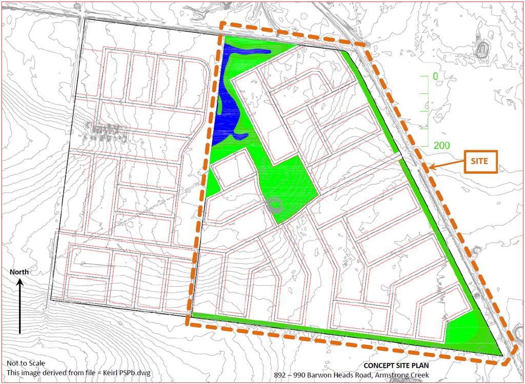
4 2 Development Proposal 2.1 Site Location The proposed development site is located at Barwon Heads Road in Armstrong Creek, refer to Figure 1. The site is bounded by Barwon Heads Road to the east, vacant land to the south and the Armstrong Creek Urban Growth Area to the north and west. The site is located approximately 10km south of the Geelong town centre. In relation to Melbourne, the site is located approximately 70km south-west of the CBD. N Development Site Figure 1: Locality plan (source: Site Plan The residential development of the 52 hectare site is proposed to provide 600 lots. A copy of the concept site plan is provided in Appendix A. Features of the development proposal include: + Primary vehicular access point on Barwon Heads Road; + Secondary vehicular access to the site provided via a local road connection to the adjacent development within the Armstrong Creek Urban Growth Area (i.e. Armstrong Waters); and + Extension of the wetlands and open space areas adjacent to the north-west boundary of the site. SMEC Australia Page 2
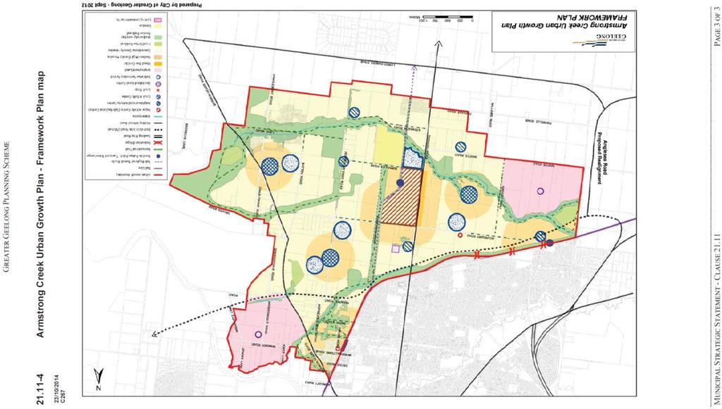
5 3 Existing Conditions Assessment 3.1 Greater Geelong Planning Scheme Clause 21 of the Greater Geelong Planning Scheme defines the objectives, strategies and actions of the Municipal Strategic Statement (MSS) for guiding land use and development in Greater Geelong. Clause identifies the proposed development site as forming part of the rural break between the Armstrong Creek Urban Growth Area and the Surf Coast Shire. Refer to Appendix B for a copy of the Armstrong Creek Urban Growth Plan Armstrong Creek East Precinct Structure Plan The Armstrong Creek Urban Growth Area is the primary growth area for Greater Geelong. It is expected to ultimately accommodate approximately 54,000 residents in 22,000 dwellings and provide 22,000 jobs. A Precinct Structure Plan (PSP) has been developed for the Armstrong Creek Eastern Precinct to achieve the vision for urban development in the area set out in the Greater Geelong Planning Scheme. The PSP sets objectives and provides for their implementation in relation to eight key elements: + Image and character; + Subdivision and housing; + Community facilities; + Public open space, natural systems and biodiversity; + Employment and activity centres; + Transport and movement; + Utilities and energy; and + Drainage and floodplain management Transport and Movement The Armstrong Creek East PSP identifies key road, public transport and walking and cycling infrastructure requirements to provide a permeable transport network suitable to cater for the expected future traffic demand. With regard to the proposed development site, the following transport network requirements have been considered: + Barwon Heads Road is expected to be duplicated at some stage in the future, subject to traffic growth and consideration by VicRoads. + Warralily Boulevard is shown as a Level 2 Connector with dedicated on-road cycle lanes. A secondary bus route is also recommended along Warralily Boulevard between Barwon Heads Road and Surf Coast Highway. + Charlemont Road is shown as a Level 1 Connector. The section to the south of Warralily Boulevard is shown as a potential secondary bus route to Lower Duneed Road, and the section to the north of Warralily Boulevard (renamed as Carter Road) has a 3.0m wide shared path on one side of the road to cater for cyclists. + Walking and cycling links are to be provided within the wetlands and open space areas to the north and west of the site. SMEC Australia Page 3
 to the south and east; + Urban Growth Zone (UGZ2) to the north and west (Armstrong Creek Urban Growth Area); and + Road Zone (RDZ1) for")
6 3.2 Land Use The proposed development site is located in a Farming Zone (FZ), refer to Figure 2. A Floodway Overlay (FO) and Land Subject to Inundation Overlay (LSIO) also apply to the site. Key land uses surrounding the site include: + Farming Zone (FZ) to the south and east; + Urban Growth Zone (UGZ2) to the north and west (Armstrong Creek Urban Growth Area); and + Road Zone (RDZ1) for Barwon Heads Road to the east. Development Site N Figure 2: Land use plan (source: Road Network Barwon Heads Road Barwon Heads Road is an arterial road under the management and control of VicRoads. It provides a main road connection between Geelong and Barwon Heads/ Ocean Grove with access to Warralily Estate provided via a signalised intersection. Access to local roads and properties is also permitted via unsignalised intersections. Barwon Heads Road is a two-lane, single carriageway road which runs in a mainly north-south direction between the Princes Highway in Geelong and Lower Duneed Road in Connewarre. Its orientation then changes to an east-west direction to Barwon Heads and Ocean Grove. The posted speed limit on Barwon Heads Road varies along its length as the road travels through urban and rural areas. Adjacent to the site the posted speed limit is 100km/h, which decreases to 80km/h on both approaches to the Warralily Boulevard signalised intersection to the north of the site. SMEC Australia Page 4


7 The alignment of Barwon Heads Road in the vicinity of the site is flat with some gentle horizontal curves. On both approaches to the proposed site access point, the road alignment is straight and flat providing adequate sight distance to the new intersection. Refer Photo 1 and Photo 2. Photo 1: Barwon Heads Road, looking north Photo 2: Barwon Heads Road, looking south SMEC Australia Page 5

8 3.3.2 Warralily Boulevard Warralily Boulevard is the main road through Warralily Estate, providing a connection between Barwon Heads Road to the east and Surf Coast Highway to the west of the estate. An urban default speed limit of 50km/h applies to the road. Warralily Boulevard is a residential collector road which runs in a mainly east-west direction to the north of the site. The carriageway is 10.4m wide within a 24.4m wide road reserve. Indented onstreet parking is provided adjacent to residential properties on both sides of the road. The alignment of Warralily Boulevard is flat with gentle horizontal curves. Channelised right turn lanes are provided at its intersections with Charlemont Road and Carter Road; refer to Photo 3 and Photo 4 respectively. Photo 3: Warralily Boulevard, west approach to Charlemont Road SMEC Australia Page 6

9 3.3.3 Charlemont Road Photo 4: Warralily Boulevard, east approach to Carter Road Charlemont Road is a local road which runs in a mainly north-south direction to the west of the site. Its alignment comprises some gentle horizontal curves on the approaches to its intersection with Warralily Boulevard. An urban default speed limit of 50km/h applies to the road. The section to the south of Warralily Boulevard comprises a sealed carriageway approximately 7.3m wide within a 20.0m wide road reserve, refer to Photo 5. On-street parking is permitted on both sides of the road. It is noted that this cross section is to be provided along the length of Charlemont Road within the estate. Refer to Appendix D. To the north of Warralily Boulevard, Charlemont Road has been renamed as Carter Road and will ultimately provide access to the Armstrong Creek town centre. The carriageway is 7.0m wide within a 27.5m wide road reserve and on-street parking is permitted on both sides of the road. refer to Photo 6 and Appendix D. Carter Road (previously Charlemont Road) connecting Warralily Boulevard and The Neighbourhood Activity Center is referred to in an earlier document, Armstrong Creek Eastern Precinct Report Warralily Stage 1 to 11 by Cardno Grogan Richards and dated 3 May SMEC Australia Page 7


10 Photo 5: Charlemont Road, looking north Photo 6: Carter Road, looking north SMEC Australia Page 8
11 3.4 Traffic Data Casualty Accident Statistics VicRoads Crashstats database indicates that two casualty crashes have been recorded along Barwon Heads Road in the vicinity of the site, in the five-year period between January 2009 and December One crash involved a car travelling north-west on Barwon Heads Road leaving the carriageway to the right and hitting a tree (DCA 173). The other crash involved a utility vehicle travelling south-east on Barwon Heads Road hitting a horse on the carriageway (DCA 167). Both crashes occurred south of Lake Road during night-time conditions and resulted in serious injury to the vehicle occupants. It is noted that these crashes occurred prior to the development of Warralily Estate within the Armstrong Creek Urban Growth Area Traffic Volumes The Armstrong Creek Eastern Precinct Traffic Impact Assessment report indicates the following future traffic volumes on the road network in the vicinity of the site: + Barwon Heads Road, south of Warralily Boulevard 4,200 vehicles per day + Warralily Boulevard, east of Charlemont Road 6,000 vehicles per day + Charlemont Road 3,700 vehicles per day Adopting a conservative approach, it is considered appropriate to assess the impact of the proposed development based on the volume of traffic expected to use these roads following full development of the precinct. 3.5 Public Transport Network Rail The closest train station to the proposed development site is Marshall Station, which is located 5.0km north-west of the site via Marshalltown Road. VLine train services operate daily via Marshall Station between Melbourne and Geelong, and between Geelong and Warrnambool. There are 400 car parking spaces provided at the station as well as bicycle storage facilities Bus Routes There is currently one bus route operating along Barwon Heads Road adjacent to the site. Route 80 runs between Geelong Station and Ocean Grove via Marshall Station and Barwon Heads, refer to Figure 3. The closest bus stop is located at the Barwon Heads Road/ Warralily Boulevard intersection, which is approximately 400m from the northern boundary of the site. SMEC Australia Page 9

12 Development Site Figure 3: Bus Route 80 (source: Walking and Cycling Facilities On-road bicycle lanes are provided on Barwon Heads Road at its intersection with Warralily Boulevard, and along Warralily Boulevard through the estate. Cyclists are permitted to continue along Barwon Heads Road with sealed shoulders provided on both sides of the carriageway. Along the south side of Warralily Boulevard there is a shared path network provided through the wetlands and open space areas, which continues under the bridge between Charlemont Road and Carter Road. Connections to the off-road shared path facilities in the wetlands area are also provided on both sides of Warralily Boulevard. Footpaths are provided on both sides of Warralily Boulevard and Charlemont Road. Carter Road has a widened road reserve to maintain the trees within the verge and provide a 3.0m wide shared path on the west side of the road. A footpath is also provided on the east side of Carter Road. SMEC Australia Page 10
13 4 Traffic Impact Assessment 4.1 Trip Generation The Armstrong Creek Eastern Precinct Traffic Impact Assessment report indicates that a trip generation rate of 8 vehicle movements per residential lot per day has been adopted for the precinct. As the proposed development site is considered an extension of the Armstrong Creek Urban Growth Area, the same rate will be adopted for the residential dwellings within this site. Based on a 600 lot residential development, the proposed development site is expected to generate 4,800 vehicle trips per day. Assuming that 10% of daily vehicle trips are made in the peak hour; 480 vehicle trips would be expected to occur in the peak hour. 4.2 Trip Distribution Generally, about 25% of trips generated by a new subdivision are internal trips made within the site. These internal trips include local shopping, school, recreation and local social visits. The remaining 75% of trips generated by the site are external trips made to/ from the site Internal Trips For the proposed development site, it is expected that approximately 1,200 vehicle trips per day or 120 vehicle trips in the peak hour will be internal trips. Given the provision of local shopping, school and recreation facilities within Warralily Estate, these internal trips are expected to use the local road connection to the adjacent residential area (i.e. Armstrong Waters) and Charlemont Road to enter/ exit the site External Trips The remaining 3,600 vehicle trips per day or 360 vehicle trips in the peak hour generated by the proposed development site are expected to be external trips. The majority of external vehicle trips generated by residential lots in the peak hour are home-to-work trips. Therefore, the distribution of traffic to/ from the site has been determined based on the location of the site in relation to the location of external employment areas. It is therefore assumed that residents would use Barwon Heads Road to enter/ exit the site as follows: + 90% of residents travel north towards Geelong and Melbourne; and + 10% of residents travel south towards Torquay, Barwon Heads and Ocean Grove. Figure 4 shows the distribution of generated traffic volumes from the site to the surrounding road network. SMEC Australia Page 11
14 90% 75% 10% 25% Figure 4: Distribution of site traffic The directional distribution of traffic accessing the site is based on the assumption that 80% exit and 20% enter the site during the AM peak, and 40% exit and 60% enter the site during the PM peak (source: Traffic Engineering and Management, K W Ogden and S Y Taylor, 1996, Section 8.1) Impact on Existing Traffic Movements The proposed local road connection to the adjacent development (i.e. Armstrong Waters) would provide some residents of this development with an additional access point to Barwon Heads Road. As a result, it is expected that the new access point would re-distribute some traffic from Charlemont Road to the new access road. This is considered particularly relevant for the southern portion of the Armstrong Waters development area in the vicinity of the local road providing access to the site as it would provide a shorter route to Barwon Heads Road with less traffic expected in comparison to Warralily Boulevard (i.e. 6,000 vehicles per day from Section 3.4.2). The number of trips that this new local road connection is expected to have an impact on is estimated at 1,200 vehicle trips per day (based on the daily external trip generation of the 200 residential lots within the southern portion of the Armstrong Waters development area). Therefore the total number of trips expected to use the new access point on Barwon Heads Road is 4,800 vehicles per day, and the total number of trips expected to use the local access road is approximately 2,400 vehicles per day. Within Armstrong Waters, the nett effect on Charlemont Road would be zero as the number of trips diverted away from Charlemont Road is expected to be similar to the number of trips expected to use it to/ from the proposed development site. The local road providing access to the site however is expected to get busier with the addition of the internal trips generated by the proposed development site. Therefore the volume of traffic expected on this local access road is approximately 2,800 SMEC Australia Page 12

15 vehicles per day (based on the total daily trip generation of the 200 residential lots within the southern portion of the Armstrong Waters development area). 4.3 Trip Assignment From the trip generation and distribution assumptions outlined above, traffic accessing the proposed development site can be assigned to Barwon Heads Road and the local road providing a secondary access point to the site Barwon Heads Road Table 1 summarises the predicted peak hour traffic movements on the primary access road following full development of the site. Table 1: Peak hour private vehicle movements accessing the site Access Road Total Peak Hour Vehicle Trips AM Peak 80% Exit 20% Enter Total Peak Hour Vehicle Trips PM Peak Barwon Heads Road: North Barwon Heads Road: South Total % Exit 60% Enter The assignment of traffic during the AM and PM peak hours accessing the site via Barwon Heads Road is presented in Figure AM Peak Figure 5: Assignment of traffic to Barwon Heads Road PM Peak SMEC Australia Page 13

16 4.3.2 Local Access Road The predicted peak hour traffic movements on the local road providing access to the site, is presented in Figure 6. It is noted that the traffic volumes expected to move from the Barwon Heads Road development westward to connect with Charlemont Road is slightly under a balance figure of vehicle trip exchanged between the two developments. The outcome of this slight imbalance is that a slight reduction in the peak hour operation of Charlemont Road can be expected Figure 6: Assignment of traffic to local access road 4.4 Midblock Assessment Existing Road Capacity The one-way midblock capacity of a traffic lane on an undivided road with interrupted traffic flow is 900 vehicles per hour (source: Austroads Guide to Traffic Management, Part 3: Traffic Studies and Analysis, Section 5.2). This can be increased to 1,200 to 1,400 vehicles per hour when the following conditions are implemented: + Adequate flaring at major upstream intersections; + Uninterrupted flow from a wider carriageway upstream of an intersection approach and flowing at capacity; + Control or absence of crossing or entering traffic at minor intersections by major road priority controls; + Control or absence of parking; + Control or absence of right turns by banning turning at difficult intersections; SMEC Australia Page 14
17 + High volume flows of traffic from upstream intersections during more than one phase of a signal cycle; and + Good co-ordination of traffic signals along the route Barwon Heads Road Based on the proposed operating conditions of Barwon Heads Road in the Armstrong Creek East PSP, a one-way midblock capacity of 1,200 vehicles per hour has been adopted for this assessment. The Armstrong Creek Eastern Precinct Traffic Impact Assessment report indicates a peak one-way traffic flow on Barwon Heads Road adjacent to the site of 310 vehicles per hour in the AM peak travelling north towards Geelong and Melbourne. Therefore, Barwon Heads Road is expected to operate at approximately 26% of its theoretical capacity during the peak hour Local Access Road A one-way midblock capacity of 900 vehicles per hour has been adopted for the local road providing access to the site. Based on the total daily trip generation of 200 residential lots within the adjacent development, it is estimated that approximately 1,600 vehicles per day would use this local access road. Assuming that 10% of vehicle trips occur in the peak hour, the peak traffic volume on this road equates to 160 vehicles per hour. Adopting a worst case scenario whereby this traffic volume represents a one-way traffic flow, the local access road within Armstrong Waters is expected to operate at approximately 18% of its theoretical capacity during the peak hour Post Full Development Assessment Barwon Heads Road Following the development of the site, an additional 480 vehicle trips in the peak hour are expected along Barwon Heads Road. Assuming that 90% of traffic exiting the site in the AM peak would travel in a northbound direction along Barwon Heads Road, the development would contribute an extra 346 vehicles in the AM peak hour. Therefore at full development of the site, the number of one-way vehicle trips in the peak hour along Barwon Heads Road to the north of the site would equate to 656 vehicles per hour. Barwon Heads Road would therefore operate at approximately 55% of its capacity during the AM peak hour. As a result, the traffic generated by the site would not have an adverse impact on the operating conditions of Barwon Heads Road when the development is fully constructed Local Access Road Following the development of the site, an additional 120 vehicle trips in the peak hour are expected along the local road providing access to the site. Adopting a worst case scenario whereby this traffic volume represents a one-way traffic flow, the peak traffic volume on this local road would equate to 280 vehicles per hour. The local access road within Armstrong Waters would therefore operate at approximately 31% of its capacity during the peak hour. As a result, the traffic generated by the site would not have an adverse impact on the operating conditions of the local road providing access to the site when the development is fully constructed. SMEC Australia Page 15
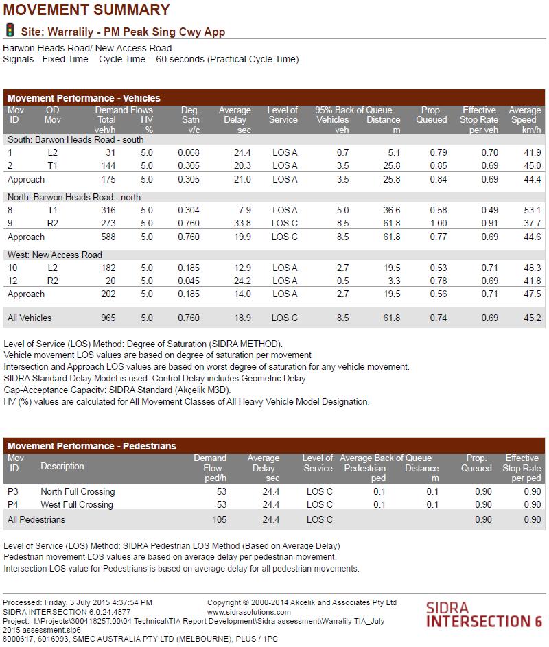
18 4.5 Intersection Assessment SIDRA Analysis SIDRA Intersection 6.0 was used to assess the performance of the Barwon Heads Road/ New Access Road intersection under full development conditions. SIDRA is a key tool used for this type of assessment as it helps identify the Level of Service and Degree of Saturation of the intersection. Level of Service (LOS) is defined as a qualitative measure for ranking operating conditions, based on factors such as speed, travel time, freedom to manoeuvre, interruptions, comfort and convenience 1. There are six levels of service, from A to F, with LOS A representing the best operating condition and LOS F the worst, ibid. LOS C or better is generally accepted as an appropriate level of operation. The Degree of Saturation (DOS) is defined as the ratio of the arrival flow (demand) to the capacity of the approach during the same period 1. The degree of saturation of an intersection approach ranges from close to zero for very low traffic flows and up to one for saturated flow or capacity, ibid. For signalised intersections, the practical DOS is around Table 2 sets out the DOS ranges that SIDRA uses when assessing the LOS. As can be seen, the lower the degree of saturation the better the level of service. Table 2: LOS definition Level of Service Degree of Saturation A < = 0.60 B C D E F > Austroads Guide to Traffic Management, Part 3: Traffic Studies and Analysis SMEC Australia Page 16

19 4.5.2 Post Full Development Assessment Single Carriageway The main vehicular access point to the site is proposed on Barwon Heads Road via a new signalised T-intersection with all movements permitted. A performance assessment of the New Access Road intersection with Barwon Heads Road as a single carriageway has been undertaken for the AM and PM peak periods at full development. It is expected that Barwon Heads Road will remain a single carriageway until complete build out is achieved for the Armstrong Creek development area. Development input to the traffic volumes experienced on Barwon Heads Road have been incorporated into the intersection analysis. The volumes on Barwon Heads Road have been taken from the Armstrong Creek Eastern Precinct Traffic Impact Assessment report by Cardno dated 14 Oct 2009Cardno Report. Refer to the extract image, Figure 7 below. ( WARRALILY BLVD ) Figure 7: Barwon Heads Rd / Horseshoe Bend Rd at Full Build Out The property at Barwon Heads Road, Armstrong Creek has not been considered in the earlier Armstrong Creek Eastern Precinct Structure Planning or Traffic Impact Assessment reports produced to inform the PSP development process, therefore the traffic volumes to be considered at the property are additional to those full build out volumes displayed in Figure 7 at the Barwon Heads Road / Warralily Boulevard intersection. Two way (full build out) volumes in the AM and PM peaks have been extracted from the turning movements shown in Figure 7, these two way full build out volumes have then been considered in addition to the volumes generated by the proposed development. The north south two volumes extracted from Figure 7 indicate a 70 / 30 peak hour split The author has adopted this volume split as a conservative approach to this assessment. The SMEC Australia Page 17
20 expected and reasonably considered volume split could be more in the region of a 90/10 volume split. The two way peak volumes extracted from Figure 7 are shown in Table 2a below. PEAK PERIOD NORTHBOUND SOUTHBOUND AM (hr) PM (hr) Table 2a: Two peak hour volumes across the frontage of Barwon Heads Road Below is a diagram of the Barwon Heads Road / New Access Road intersection, with Barwon Heads Road as a single carriageway. Refer to Figure 8 for the proposed intersection layout (based on the existing Barwon Heads Road/ Warralily Boulevard intersection). Figure 8: Proposed Barwon Heads Road/ New Access Road intersection- single carriageway A summary of the queue length, average delay, degree of saturation and level of service of each intersection approach is provided in Table 3. Refer to Appendix C for the full results of SIDRA analysis. SMEC Australia Page 18
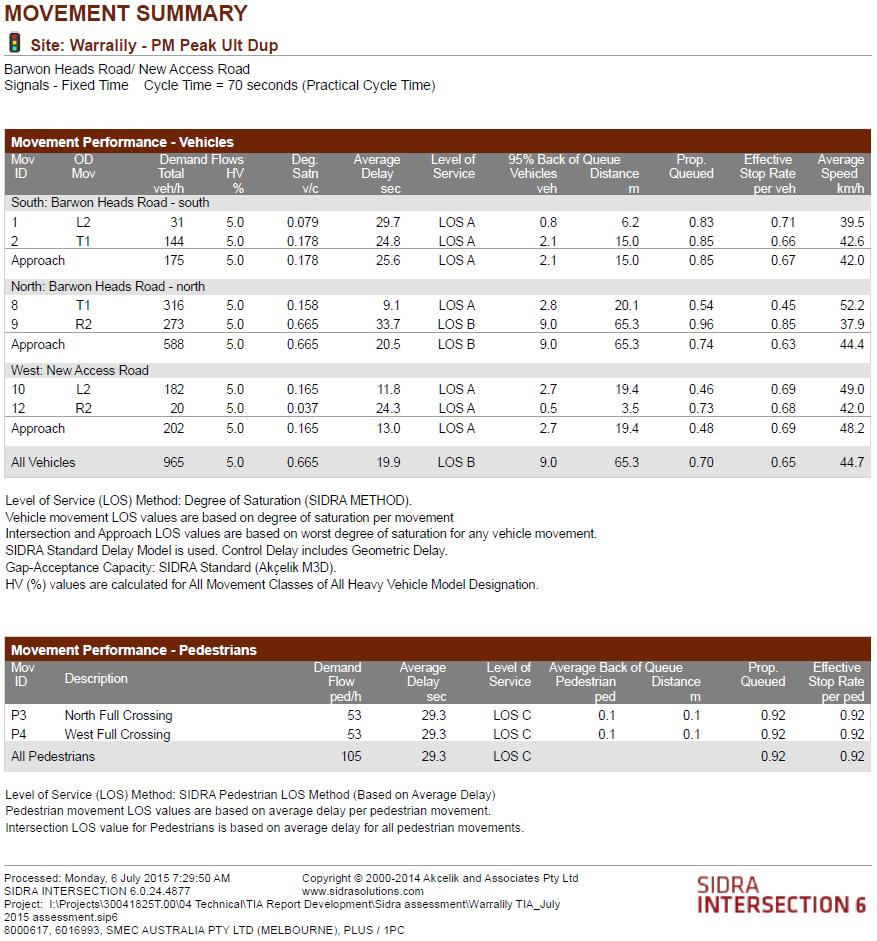
21 Table 3: Summary of results at Barwon Heads Road (Single Carriageway) / New Access Road intersection AM Peak Approach Barwon Heads Road South approach Barwon Heads Road North approach New Access Road 95 th %ile Queue (m) Average Delay (sec) Degree of Saturation Level of Service A A A PM Peak 95 th %ile Queue (m) Average Delay (sec) Degree of Saturation Level of Service A C A The results show that traffic generated by the proposed development site would create short queues, short delays and a low degree of saturation for each intersection approach during the AM and PM peak hours. They also show that, in general, the intersection would operate at LOS A with a LOS C expected on Barwon Heads Road north approach during the PM peak. Therefore the volume of traffic generated by the site would not have an adverse impact on Barwon Heads Road as a two way two lane single carriageway Post Full Development Assessment Dual Carriageway Similar in operation to the Barwon Heads Road single carriageway, the ultimate dual carriageway configuration of Barwon Heads was tested using the ultimate build out volumes offered in the Armstrong Creek Eastern Precinct Traffic Impact Assessment report by Cardno dated 14 Oct Refer to the extract image, Figure 7. The Barwon Heads Road duplicated carriageway and intersection layout assessed is shown as Figure 9. SMEC Australia Page 19
22 Figure 9: Proposed new Barwon Heads Road / New Access Road dual carriageway A summary of the queue length, average delay, degree of saturation and level of service of each intersection approach is provided in Table 4. Refer to Appendix C for the full results of SIDRA analysis. SMEC Australia Page 20
23 Table 4: Summary of results at Barwon Heads Road (Dual Carriageway) / New Access Road intersection AM Peak Approach Barwon Heads Road South approach Barwon Heads Road North approach New Access Road 95 th %ile Queue (m) Average Delay (sec) Degree of Saturation Level of Service A A A PM Peak 95 th %ile Queue (m) Average Delay (sec) Degree of Saturation Level of Service A B A The results shown in Table 4 indicate that traffic generated by the proposed development site would create short queues, short delays and a low degree of saturation for each intersection approach during the AM and PM peak hours. They also show that, in general, the intersection would generally operate at LOS A with a LOS B expected on Barwon Heads Road north approach during the PM peak. Therefore the volume of traffic generated by the site would not have an adverse impact on Barwon Heads Road as a two way two lane duplicated carriageway. 4.6 Intersection Development The proposed signalised intersection at the development access road will provide road operation, road safety and amenity benefits to future residents and road users, The benefits to the area resulting from the development include: + The establishment of a threshold to the development and will also provide a threshold to Armstrong Creek on Barwon Heads Road, establishing a visible demarcation between the rural and urban environs; + A signalised intersection at this location will slow and regulate Barwon Heads Road traffic flows and operating speeds at a location midway between Warralily Boulevard and Lower Duneed Road; + Lane discipline offered at the signalised intersection will reinforce the bicycle and pedestrian friendly operation of the roadway and provide safe bicycle access to and from the development; + The interim and ultimate signalised intersection layout is designed to fit the road reserve and land set aside by the PAO across the Barwon Heads Road frontage. The PAO is located at the west edge of the Barwon Heads Road. SMEC Australia Page 21

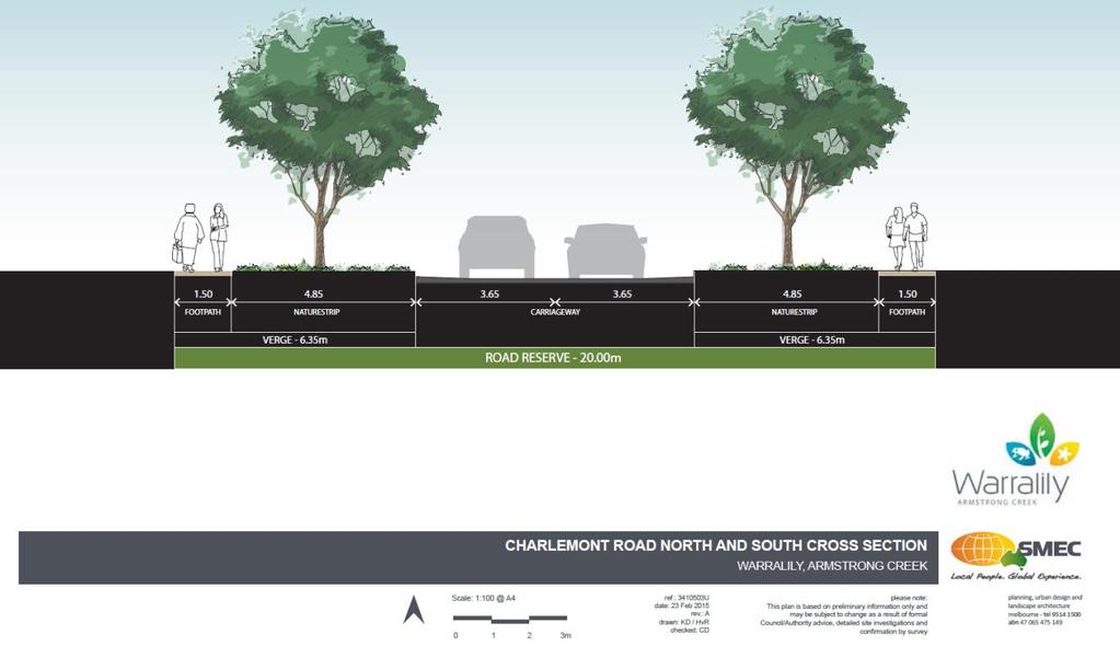
24 5 Road Network Review 5.1 Charlemont Road The Armstrong Creek East PSP sets out the road hierarchy and cross section configuration for each main road within the precinct, including Charlemont Road. Given that the impact of the proposed development site on Charlemont Road is not expected to be significant, the current 20.0m cross section for Charlemont Road would be sufficient. Refer to Appendix D for a copy of the nominated cross section. 5.2 Main Access Road The Armstrong Creek East PSP has also been used to determine the proposed cross section for the main access road into the site from Barwon Heads Road. As can be seen in Figure 10 the concept layout of the site provides a dominant Connector Road leading into the proposed development parcel that reduces roadway functionality to a Key Local Access Street meeting the connectivity needs of those lots located in the southern portion of the site and the adjacent Armstrong Waters development area. The intention of the Key local Access Street is to facilitate a focussed connection to those areas deep within both development parcels whilst ensuring the road function and width remain in balance with the residential nature of this area. Signalised Intersection Connector Road Key Local Access Street Figure 10: Connector Road and Key Local Streets Based on the expected traffic volume of 4,800 vehicles per day and the function of the main access road as a connector street, it is proposed that a 21.6m wide cross section (based on Figure M and Figure N from the PSP) be provided with the following features: SMEC Australia Page 22
25 + 3.5m wide traffic lanes, one in each direction; + 2.3m wide on-street parking lanes; and + 1.5m wide footpath on both sides of the road. A copy of the nominated cross section is provided in Appendix D 5.3 Local Road Network Clause of the Greater Geelong Planning Scheme sets out the design requirements for the local road network within the municipality. The Armstrong Creek East PSP specifies the local road cross section configurations within the precinct based on these design requirements. A summary of the PSP equivalent cross sections, indicative traffic volumes and road reservation widths for each local road type in the Planning Scheme is provided in Table 4. Table 4: Classification of local roads Clause Classification PSP Equivalent Road Cross Section Indicative Vehicles Per Day Road Reserve Width (m) Access Lane Access Lane (Figure U) Up to Access Place Access Place (Figure V) 300 to 1, Access Street Level 1 Access Street Level 2 Typical Local Access Street Beside Public Open Space (Figure S) Typical Local Access Street (Figure R) 1,000 to 2, ,000 to 3, Based on the expected traffic volume of 2,400 vehicles per day using the local road connection to the adjacent development, it is proposed that a typical local access street cross section with a 16.0m wide road reserve be adopted. Refer to Appendix D for a copy of the nominated cross section. It is also proposed that this cross section be extended to Charlemont Road along the local road providing access to the site through the Armstrong Waters development. 5.4 Barwon Heads Road Barwon Heads Road as an interim condition is to operate as a two way two lane single carriageway until full build out of the Armstrong Creek Precinct. Ultimately Barwon Heads Road will be constructed as a two way four lane dual carriageway roadway, the timing of the implementation of the ultimate cross section will be determined by others. SMEC has developed a Barwon Heads Road cross section to address issues of stormwater management and using the guidance offered in VicRoads drawing No , shown in Appendix E as Figure 11. The SMEC developed cross section is shown in Appendix E as Figures 12 SMEC Australia Page 23
26 6 Integrated Transport Review 6.1 Accessibility to Bus Services The majority of the proposed development site is located within the 400m walkable catchment of the existing bus route on Barwon Heads Road, as per the Department of Transport Guidelines for Land Use and Development: Public Transport, It is noted however that an additional bus stop should be provided on Barwon Heads Road at the proposed signalised T-intersection with the New Access Road (similar to the existing Barwon Heads Road/ Warralily Boulevard intersection) to improve accessibility to this service. 6.2 Connectivity to Walking and Cycling Network In keeping with the Armstrong Creek East PSP, shared path facilities should be considered in the wetlands and open space areas of the proposed development site with connections to the adjoining Warralily and Armstrong Waters shared path network. The main access road into the site is proposed to have a footpath on both sides of the road. Footpaths are also proposed on both sides of the local road connection to the adjacent development, and one or both sides of the typical local access street and access place road cross sections to be provided within the site. Connectivity between these facilities and the shared path network should be provided to create an integrated active transport network and encourage walking and cycling in the area. SMEC Australia Page 24
27 7 Conclusion In summary, this traffic impact assessment has identified the following: + The proposed development site is expected to generate 4,800 vehicle trips per day or 480 vehicle trips in the peak hour. + It is expected that 25% of trips (i.e. 1,200 vehicle trips per day) will be internal trips and use the local road connection to the adjacent residential area and Charlemont Road to enter/ exit the site. The remaining 75% of trips (i.e. 3,600 vehicle trips per day) will be external trips made to/ from the site via Barwon Heads Road. + Within Armstrong Waters, the nett effect on Charlemont Road is expected be zero; however the local road providing access to the site is expected to get busier with the addition of the internal trips generated by the site. The volume of traffic expected on this local access road is 2,800 vehicles per day. + The proposed local road connection to the adjacent development (i.e. Armstrong Waters) would provide some residents of this development with an additional access point to Barwon Heads Road. As a result, it is expected that the new access point would re-distribute some traffic from Charlemont Road to the new access road. + The number of trips that this new local road connection is expected to have an impact on is 1,200 vehicle trips per day. Therefore the total number of trips expected to use the new access point on Barwon Heads Road is 4,800 vehicles per day, and the total number of trips expected to use the local access road is 2,400 vehicles per day. + The results of SIDRA analysis show that, in general, the proposed Barwon Heads Road/ New Access Road signalised T-intersection at would operate at LOS A with a LOS C expected on Barwon Heads Road north approach during the PM peak. + Traffic generated by the site would not have an adverse impact on the operating conditions of Barwon Heads Road and the local road providing access to the site when the development is fully constructed. + The current 20.0m cross section for Charlemont Road is expected to be sufficient. + A 21.6m wide cross section is proposed for the main access road into the site. + A typical local access street cross section with a 16.0m wide road reserve is proposed for the local road connection to the adjacent development. It is expected that this cross section would be extended to Charlemont Road through the Armstrong Waters development. + The majority of the site is located within the 400m walkable catchment of the existing bus route on Barwon Heads Road; however an additional bus stop should be provided on Barwon Heads Road to improve accessibility to this service. + Shared path facilities should be considered in the wetlands and open space areas of the site with connections to the adjoining Warralily and Armstrong Waters shared path network. Connectivity with the proposed walking and cycling facilities within the road cross sections should also be provided to create an integrated active transport network and encourage walking and cycling in the area. Based on the findings of this report, SMEC is of the opinion that the proposed rezoning of the site at Barwon Heads Road in Armstrong Creek for residential development will not have an adverse impact on the operation of the road network adjacent to the site. SMEC Australia Page 25
28 Rev No. Date Prepared by Reviewed by Approved by A 16/02/15 C. Emmitt M. De Marco P. Ridgeway B 02/04/15 C. Emmitt M. De Marco P. Ridgeway C 19/05/15 P. Ridgeway M. De Marco P. Ridgeway D 06/07/15 P. Ridgeway M. De Marco E 08/07/15 P. Ridgeway M. De Marco Our Reference: T Contact for further information: Phill Ridgeway Senior Associate Transport Engineer SMEC Australia Pty Ltd (03) phill.ridgeway@smec.com Snowy Mountains Engineering Corporation (SMEC Australia Pty Ltd) The information within this document produced by SMEC Australia is solely for the use of the Client identified on the cover sheet for the purpose for which it has been prepared. SMEC Australia undertakes no duty to or accepts any responsibility to any third party who may rely upon this document. All rights reserved. No section or element of this document may be removed from this document, reproduced, electronically stored or transmitted in any form without the written permission of SMEC Australia.
29 Page intentionally left blank
30 Appendix A Concept Site Plan
31
32 Appendix B Armstrong Creek Urban Growth Plan
33
34 Appendix C SIDRA Movement and Phasing Summaries

35 Barwon Heads Road Single (Interim) Carriageway Treatment Intersection with New Access Road
36

37 Barwon Heads Road Duplicated (Ultimate) Carriageway Treatment Intersection with New Access Road
38
39
40 Appendix D Internal Road Cross Sections
41
42
43
44 Note: Charlemont Road between Warralily Boulevard and The Neighborhood Activity Center now renamed Carter Road. Refer to Armstrong Creek Eastern Precinct Report Warralily Stage 1 to 11 by Cardno Grogan Richards and dated 3 May 2011
45 Appendix D External Road Cross Sections (Barwon Heads Road)
46 Figure 11: VicRoads Developed Barwon Heads Road Cross Sections
47 Figure 12: SMEC Developed Barwon Heads Road Cross Sections
48 Page left intentionally blank
PROPOSED RESIDENTIAL SUBDIVISION
 PROPOSED RESIDENTIAL SUBDIVISION PART OF TARNEIT ROAD & 1121 DOHERTYS ROAD, TARNEIT Prepared For: TCG (RM) Developments Pty Ltd MARCH 2014 OUR REF: 16740R#1 PROPOSED RESIDENTIAL SUBDIVISION PART OF TARNEIT
Traffic and Transport Assessment
 Traffic and Transport Assessment Section 96 Residential Subdivision, Davis Road Tarneit CG120370 Prepared for Stockland Pty Ltd 19 February 2013 Document Information Prepared for Stockland Pty Ltd Project
PLAN 20 PUBLIC TRANSPORT NETWORK
 KEY Bus Route / 400m Coverage Existing Recommended Secondary Potential Secondary Indicative Stop Locations Principle Standard Sub-regional Transit Corridor Reservation PLAN 0 PUBLIC TRANSPORT NETWORK Date:
BROMPTON LODGE, CRANBOURNE PRECINCT STRUCTURE PLAN TRAFFIC ENGINEERING ASSESSMENT WOLFDENE PTY LTD PREPARED FOR
 BROMPTON LODGE, CRANBOURNE PRECINCT STRUCTURE PLAN TRAFFIC ENGINEERING ASSESSMENT PREPARED FOR WOLFDENE PTY LTD TRAFFIC ENGINEERING ASSESSMENT PRECINCT STRUCTURE PLAN AT BROMPTON LODGE, CRANBOURNE Document
Minta Farm Berwick S96A Transport Impact Assessment
 Minta Farm Berwick S96A Transport Impact Assessment 170310TIA001I-F 4 October 2017 onemilegrid ABN: 79 168 115 679 (03) 9939 8250 1/59 Keele Street COLLINGWOOD, VIC 3066 www.onemilegrid.com.au DOCUMENT
1 VicRoads Access Management Policies May 2006 Ver VicRoads Access Management Policies May 2006 Version 1.02
 1 VicRoads Access Management Policies May 2006 Ver 1.02 VicRoads Access Management Policies May 2006 Version 1.02 2 VicRoads Access Management Policies May 2006 Ver 1.02 FOREWORD FOR ACCESS MANAGEMENT
Ministry of Education Flat Bush School Notice of Requirement. Integrated Transportation Assessment Report. February 2016
 Ministry of Education Flat Bush School Notice of Requirement Integrated Transportation Assessment Report February 2016 TDG Ref: 12988-2 151105 ita flat bush.docx Ministry of Education Flat Bush School
Berwick Health and Education Precinct: Casey Amendment C207 (Part 1) Submission to Planning Panels Victoria
 Submission to Planning Panels Victoria") Berwick Health and Education Precinct: Casey Amendment C207 (Part 1) Submission to Planning Panels Victoria August 2018 CONTENTS 1 Executive summary... 1 2 Summary of the amendment... 2 3 Submission...
Berwick Health and Education Precinct: Casey Amendment C207 (Part 1) Submission to Planning Panels Victoria August 2018 CONTENTS 1 Executive summary... 1 2 Summary of the amendment... 2 3 Submission...
STATEMENT TO PLANNING PANELS VICTORIA BY WILLIAM DE WAARD, TRAFFIC ENGINEER
 Amendment C228 to the Casey Planning Scheme Traffic Engineering Assessment Planning Panels Victoria Panel Hearing Date: Monday 16 th April, 2018 Report Date: 5 th April, 2018 Prepared for the Applicant:
Welcome. If you have any questions or comments on the project, please contact:
 Welcome This drop-in public open house is intended to provide information about the Bay Street bike lanes project. This project proposes a dedicated cycling facility along Bay Street between Aberdeen Avenue
Proposed Residential & Retail Development at Geelong Rd Portarlington
 Batman Invest Traffic Impact Assessment Proposed Residential & Retail Development at 30-32 Geelong Rd Portarlington Batman Invest Traffic & Parking Impact Assessment for Proposed Residential & Retail Development
Traffic Engineering Assessment. Additional Traffic Modelling at Minta Farm PSP 11. Prepared for Victorian Planning Authority
 Additional Traffic Modelling at Minta Farm PSP 11 Prepared for Victorian Planning Authority Traffic Engineering Assessment Additional Traffic Modelling at Minta Farm PSP 11 Document Control Issue No. Type
INDUSTRIAL BUILDING 3009 HAWTHORNE ROAD CITY OF OTTAWA TRANSPORTATION OVERVIEW REVISED. Prepared for: Canada Inc.
 INDUSTRIAL BUILDING 3009 HAWTHORNE ROAD CITY OF OTTAWA TRANSPORTATION OVERVIEW REVISED Prepared for: 7849648 Canada Inc. Octiober 1, 2015 114-598 Overview_2.doc D. J. Halpenny & Associates Ltd. Consulting
HENDERSON DEVELOPMENT 213, 217, 221, 221 ½, 223 HENDERSON AVENUE and 65 TEMPLETON STREET OTTAWA, ONTARIO TRANSPORTATION OVERVIEW.
 HENDERSON DEVELOPMENT 213, 217, 221, 221 ½, 223 HENDERSON AVENUE and 65 TEMPLETON STREET OTTAWA, ONTARIO TRANSPORTATION OVERVIEW Prepared for: 2294170 Ontario Inc. February 2, 2017 117-652 Report_1.doc
Classification Criteria
 SCHEDULE D TO RECOMMENDED OFFICIAL PLAN AMENDMENT NO. 40 SCHEDULE C-4 Road Criteria Criteria Traffic Service Objective Land Service/Access Typical Daily Traffic Volume Flow characteristics Travel Speed
Acland Street, St Kilda
 Acland Street, St Kilda Traffic Redistribution Client: Yarra Trams Project No. 122531 Draft_4 Report 16/09/13 Suite 1, 1 st Floor 132 Upper Heidelberg Road Ivanhoe Vic 3079 PO Box 417 Ivanhoe Vic 3079
Sixth Line Development - Transit Facilities Plan
 Memorandum Date: November 13, 2012 To: From: c.c. Subject: Rob Freeman (Freeman Planning) Kevin Phillips Sixth Line Development - Transit Facilities Plan 33016631 This memo was prepared to review the transit
Response to further information request Ministry of Education Notice of Requirement (200 & 252 Park Estate Road)
") 21 Pitt Street PO Box 6345, Auckland 1141, New Zealand T: +64 9 300 9000 // F: +64 9 300 9300 E: info@beca.com // www.beca.com Auckland Council Private Bag 92300 Victoria Street West Auckland 1142 15 August
21 Pitt Street PO Box 6345, Auckland 1141, New Zealand T: +64 9 300 9000 // F: +64 9 300 9300 E: info@beca.com // www.beca.com Auckland Council Private Bag 92300 Victoria Street West Auckland 1142 15 August
Harriet Fraser Traffic Engineering & Transportation Planning
 Appendix 5: Traffic Assessment 71 26 February 2015 Mr James Beban Senior Resource Consents Planner Cuttriss Consultants Ltd PO Box 30429 Lower Hutt PO Box 40170 Upper Hutt 5140 P 04 526 2979 M 027 668
Ministry of Education Notice of Requirement, North City High School. Transportation Assessment Report. July 2010
 Ministry of Education Notice of Requirement, North City High School Transportation Assessment July 2010 PO Box 1261, Level 1, 7 Hardley Street Hamilton 3240 P: +64 7 839 550 www.tdg.co.nz New Zealand 10574ta_v6.doc
Appendix A Maunsell Traffic Report
 Appendix A Maunsell Traffic Report Mooroopna West Growth Corridor Structure Plan T:\300 232 04 Mooroopna West ODP\3.0 Deliverables\July 2009 Reports\Structure Plan\Mooroopna West Growth Corridor Structure
At each type of conflict location, the risk is affected by certain parameters:
 TN001 April 2016 The separated cycleway options tool (SCOT) was developed to partially address some of the gaps identified in Stage 1 of the Cycling Network Guidance project relating to separated cycleways.
MEDICAL/OFFICE BUILDING 1637 BANK STREET OTTAWA, ONTARIO TRANSPORTATION OVERVIEW. Prepared for:
 MEDICAL/OFFICE BUILDING 1637 BANK STREET OTTAWA, ONTARIO TRANSPORTATION OVERVIEW Prepared for: 2434984 Ontario Inc. 13-5510 Canotek Road Ottawa, Ontario K1J 9J5 June 4, 2015 115-613 Report_2.doc D. J.
DUNBOW ROAD FUNCTIONAL PLANNING
 DUNBOW ROAD FUNCTIONAL PLANNING Final Report August 3, 216 #31, 316 5th Avenue NE Calgary, AB T2A 6K4 Phone: 43.273.91 Fax: 43.273.344 wattconsultinggroup.com Dunbow Road Functional Planning Final Report
MEETING FACILITY 2901 GIBFORD DRIVE CITY OF OTTAWA TRANSPORTATION BRIEF. Prepared for: Holiday Inn Express 2881 Gibford Drive Ottawa, ON K1V 2L9
 MEETING FACILITY 2901 GIBFORD DRIVE CITY OF OTTAWA TRANSPORTATION BRIEF Prepared for: Holiday Inn Express 2881 Gibford Drive Ottawa, ON K1V 2L9 December 18, 2012 112-566 Brief_1.doc D. J. Halpenny & Associates
EXECUTIVE SUMMARY Callan Park accommodates travel from a wide range of transport modes, including walking, cycling, bus and light rail.
 TRANSPORT AND ACCESS EXECUTIVE SUMMARY Callan Park accommodates travel from a wide range of transport modes, including walking, cycling, bus and light rail. Whilst there are some walking facilities within
Minta Farm Precinct Structure Plan
 Minta Farm Precinct Structure Plan Concept Road Design Report Client: Victorian Planning Authority Project No. 161910 Final Report 05/10/17 1 st Floor 132 Upper Heidelberg Road Ivanhoe Vic 3079 PO Box
Pakenham East PSP 1210
 Pakenham East PSP 1210 Victorian Planning Authority Traffic and Transport: Expert Witness Statement Final C May 28, 2018 Pakenham East PSP 1210 Project No: Document Title: Document No.: Revision: IS245200
St Germain Special Activity Precinct 1425 Pound Road & 2100 Thompsons Road Clyde North Transport Impact Assessment
 St Germain Special Activity Precinct 1425 Pound Road & 2100 Thompsons Road Clyde North Transport Impact Assessment St Germain Special Activity Precinct 1425 Pound Road & 2100 Thompsons Road, Clyde North
HANNA STREET, NOBLE PARK PROPOSED RESIDENTIAL REZONING TRAFFIC ENGINEERING ASSESSMENT YARRAMAN PARK DEVELOPMENTS PREPARED FOR JUNE, 2012
 48-146 HANNA STREET, NOBLE PARK PROPOSED RESIDENTIAL REZONING TRAFFIC ENGINEERING ASSESSMENT PREPARED FOR YARRAMAN PARK DEVELOPMENTS JUNE, 2012 14034R#1 TRAFFIC ENGINEERING ASSESSMENT PROPOSED RESIDENTIAL
13M /09/13. St Germain Special Activity Precinct 1425 Pound Road & 2100 Thompsons Road Clyde North Transport Impact Assessment.
 St Germain Special Activity Precinct 1425 Pound Road & 2100 Thompsons Road Clyde North Transport Impact Assessment d r a f t TIA/RSAMA VIC (130603 v7.2)) St Germain Special Activity Precinct 1425 Pound
APPENDIX 2 LAKESHORE ROAD TRANSPORTATION REVIEW STUDY EXECUTIVE SUMMARY
 APPENDIX 2 LAKESHORE ROAD TRANSPORTATION REVIEW STUDY EXECUTIVE SUMMARY Appendix 2 City of Mississauga Lakeshore Road FINAL REPORT Transportation Review Study December 2010 EXECUTIVE SUMMARY Study Purpose
Growth Areas Authority 31 May Wyndham North Traffic Modelling and SIDRA Analysis
 Growth Areas Authority 31 May 213 Wyndham North Traffic Modelling and SIDRA Analysis AECOM Wyndham North Traffic Modelling and SIDRA Analysis Wyndham North Traffic Modelling and SIDRA Analysis Prepared
Transit boulevard: A new road type for Sydney s Growth Centres
 Transit boulevard: A new road type for Sydney s Growth Centres Cleaver, M. A., de Roos, M. P., NSW Centre for Road Safety, Roads and Traffic Authority, NSW Collins, G., Network Services, Roads and Traffic
Traffic Modelling Report
 CG150713 Prepared for Metropolitan Planning Authority 28 September 2015 Document Information Prepared for Metropolitan Planning Authority Project Name File Reference CG150713REP001F01.docx Job Reference
Daleston Masterplan Traffic & Transport Assessment
 ` Daleston Masterplan Job Number: CG111723 Daleston Masterplan Cardno Victoria Pty Ltd ABN 47 106 610 913 150 Oxford Street, Collingwood Victoria 3066 Australia Telephone: 03 8415 7777 Facsimile: 03 8415
Traffic Modelling and Intersection Analysis
 City of Whittlesea 4-Sep-4 Traffic Modelling and Intersection Analysis Wollert Precinct Structure Plan \\aumelfp\projects\698\6. Draft Docs\6. Reports\4-9-4 Final Report.docx Revision 4-Sep-4 Prepared
Access Management Regulations and Standards for Minor Arterials, Collectors, Local Streets
 Access Management Regulations and Standards for Minor Arterials, Collectors, Local Streets September 2009 Paul Grasewicz Access Management Administrator Concept of Access Management The way to manage access
9 Leeming Drive Redevelopment Ottawa, ON Transportation Brief. Prepared By: Stantec Consulting Ltd.
 9 Leeming Drive Redevelopment Ottawa, ON Transportation Brief Prepared By: Stantec Consulting Ltd. TIA GUIDELINES CHECKLIST Report Context Municipal Address Comment: Section 1.1 Location relative to major
Services Department A September 18, 2006 Region of Durham Recommended Arterial Corridor All Wards Guidelines Study
 Report To: From: Subject: Development Services Committee Commissioner, Development Item: Date of Report: DS-06-55 September 13, 2006 File: Date of Meeting: Services Department A-2261-0002 September 18,
TRAFFIC IMPACT STUDY CRITERIA
 Chapter 6 - TRAFFIC IMPACT STUDY CRITERIA 6.1 GENERAL PROVISIONS 6.1.1. Purpose: The purpose of this document is to outline a standard format for preparing a traffic impact study in the City of Steamboat
OFFICE/RETAIL DEVELOPMENT 1625 BANK STREET OTTAWA, ONTARIO TRANSPORTATION BRIEF. Prepared for: Canada Inc.
 OFFICE/RETAIL DEVELOPMENT 1625 BANK STREET OTTAWA, ONTARIO TRANSPORTATION BRIEF Prepared for: 9402209 Canada Inc. December 15, 2015 115-625 Report_2.doc D. J. Halpenny & Associates Ltd. Consulting Transportation
CHECKLIST 2: PRELIMINARY DESIGN STAGE AUDIT
 CHECKLIST 2: PRELIMINARY DESIGN STAGE AUDIT 2.1 General topics 2.1.1 Changes since previous audit Do the conditions for which the scheme was originally designed still apply? (for example, no changes to
Speed Limits in the Hoddle Grid
 Speed Limits in the Hoddle Grid Recent History of speed limits March 2013 Docs # 7738485 1 Introduction Muncipalities have power to Erect speed limit signs BUT Municipalities DO NOT have the power to approve
GLEN EIRA CITY COUNCIL. MURRUMBEENA Transforming our neighbourhood together our concepts based on your ideas
 GLEN EIRA CITY COUNCIL MURRUMBEENA Transforming our neighbourhood together our concepts based on your ideas 1 WHAT HAVE WE HEARD? WHAT NOW? Stage one Tell us what you love about your shopping strip November
TRANSPORTATION NEEDS ASSESSMENT
 TRANSPORTATION NEEDS ASSESSMENT A travel demand analysis was carried out to determine the operational issues and the potential benefit that adding traffic capacity would have on the road network. All the
DESIGN CODE. Enterprise West Harlow London Road North Design Code 21
 DESIGN CODE Enterprise West Essex @ Harlow London Road North Design Code 21 4 MAXIMUM BUILDING HEIGHTS 4.1 Table 4A sets out maximum building height standards for each character area within the LDO boundary.
OTTAWA TRAIN YARDS PHASE 3 DEVELOPMENT CITY OF OTTAWA TRANSPORTATION IMPACT STUDY. Prepared for:
 OTTAWA TRAIN YARDS PHASE 3 DEVELOPMENT CITY OF OTTAWA TRANSPORTATION IMPACT STUDY Prepared for: The Ottawa Train Yards Inc. 223 Colonnade Road South, Suite 212 Nepean, Ontario K2E 7K3 January 17, 2012
TRANSPORT AND MOVEMENT
 TRANSPORT AND MOVEMENT Movement Strategy Public Transport Cycling and Walking Road Network Parking Standards Transport Impact Assessments Traffic Management Policies DRAFT POOLBEG PLANNING SCHEME Movement
THIS PAGE LEFT BLANK INTENTIONALLY
 GA SR 25 Spur at Canal Road Transportation Impact Analysis PREPARED FOR GLYNN COUNTY, GEORGIA 1725 Reynolds Street, Suite 300 Brunswick, Georgia 31520 PREPARED BY 217 Arrowhead Boulevard Suite 26 Jonesboro,
QUICKIE C STORE AND GAS BAR 1780 HERON ROAD OTTAWA, ONTARIO TRANSPORTATION BRIEF. Prepared for:
 QUICKIE C STORE AND GAS BAR 1780 HERON ROAD OTTAWA, ONTARIO TRANSPORTATION BRIEF Prepared for: Quickie Convenience Stores Larny Holdings Ltd. c/o PBC Group April 15, 2015 115-615 Report_1.doc D. J. Halpenny
FAIRFIELD INN & SUITES HOTEL 135 THAD JOHNSON PRIVATE OTTAWA TRANSPORTATION BRIEF. Prepared for:
 FAIRFIELD INN & SUITES HOTEL 135 THAD JOHNSON PRIVATE OTTAWA TRANSPORTATION BRIEF Prepared for: Bona Building & Management Co. Ltd. Place Vanier, 333 North River Road Vanier, Ontario K1L 8B9 August 12,
Shotover Country. Proposed Private Plan Change. Transportation Assessment Report. February 2010
 Shotover Country Proposed Private Plan Change February 2010 PO Box 13 835, Armagh Christchurch 8141 P: +64 3 379 2404 www.tdg.co.nz New Zealand Shotover Country Proposed Private Plan Change Quality Assurance
NEW YORK CENTRAL PARK SUBDIVISION BLAIS STREET/ST-PIERRE STREET EMBRUN, ONTARIO TRAFFIC IMPACT STUDY. Prepared for:
 NEW YORK CENTRAL PARK SUBDIVISION BLAIS STREET/ST-PIERRE STREET EMBRUN, ONTARIO TRAFFIC IMPACT STUDY Prepared for: Solidex Holdings Limited & Investissement Maurice Lemieux Investments Attn: Mr. Anthony
1.5 On this basis it is fundamental that the Transport Strategy for the site focuses on the following key criteria,
 1.0 Introduction 1.1 The Transport Assessment has been prepared on behalf of Eon and Roger Bullivant Ltd in respect of the proposed mixed use sustainable urban extension of Drakelow Park. 1.2 The methodology
CITY OF OTTAWA ROADWAY MODIFICATION APPROVAL UNDER DELEGATED AUTHORITY
 RMA-2015-ATM-038 CITY OF OTTAWA ROADWAY MODIFICATION APPROVAL UNDER DELEGATED AUTHORITY DATE: April 22, 2015 SUBJECT Approval of Roadway Modifications Recommended through an Area Traffic Management Study
10 SHERFORD Town Code
 Key Fixes (Ref: Masterplan Book, section 4a. Land Use Budget and Key Fixes ) The Town Plan designs and allocates buildings, streets and spaces as accurately as possible in the understandable absence of
Appendix A. Road Classification Review of Outstanding Issues and Proposed Classifications (All Wards) Staff Report Road Classification System
 Staff Report Road Classification System") Appendix A Road Classification Review of Outstanding Issues and Proposed Classifications (All Wards) Staff Report 2000 A.1 of A.10 A.2 of A.10 STAFF REPORT January 26, 2000 To: From: Works Committee Barry
Appendix A Road Classification Review of Outstanding Issues and Proposed Classifications (All Wards) Staff Report 2000 A.1 of A.10 A.2 of A.10 STAFF REPORT January 26, 2000 To: From: Works Committee Barry
Middleton Beach Activity Centre
 Middleton Beach Activity Centre CW926600 Prepared for Landcorp 24 November 2015 24 November 2015 Cardno i Contact Information Cardno (WA) Pty Ltd Trading as Cardno ABN 77 009 119 000 11 Harvest Terrace,
March Maidstone Integrated Transport Strategy Boxley Parish Council Briefing Note. Context. Author: Parish Clerk 2 March 2016
 Context. Author: Parish Clerk 2 The Draft Integrated Transport Policy (DITS) sets out a vision and objectives, and identifies a detailed programme of interventions to support the Maidstone Borough Local
Transport Assessment. Curtis Street Plan Change
 Transport Assessment Curtis Street Plan Change Transport Assessment for Curtis Street Plan Change i Contents 1. Introduction... 1 2. Existing Conditions... 2 2.1 Location... 2 2.2 Study Area... 3 2.3
TRAFFIC STUDY GUIDELINES Clarksville Street Department
 TRAFFIC STUDY GUIDELINES Clarksville Street Department 9/1/2009 Introduction Traffic studies are used to help the city determine potential impacts to the operation of the surrounding roadway network. Two
5858 N COLLEGE, LLC N College Avenue Traffic Impact Study
 5858 N COLLEGE, LLC nue Traffic Impact Study August 22, 2016 Contents Traffic Impact Study Page Preparer Qualifications... 1 Introduction... 2 Existing Roadway Conditions... 5 Existing Traffic Conditions...
Welcome to the Open House
 Leslie Street Between 19 th Avenue and Stouffville Road Addendum to Class Environmental Assessment Study Welcome to the Open House Please sign in at the front desk. March 28, 2017 Richmond Green Sports
Figure 1: East West Connector Alignment Alternatives Concept Drawing
 Page 2 of 9 Figure 1: East West Connector Alignment Alternatives Concept Drawing The Montebello Drive extension will run north south and connect Wilsonville Road to the Boones Ferry Road to Brown Road
Appendix 5B Accessway standards and guidelines Appendix 5B Accessway standards and guidelines
 Appendix 5B standards and guidelines Appendix 5B standards and guidelines 204 Appendix 5B standards and guidelines Introduction This Appendix sets out Transit s safety standards for accessways onto state
NORTHSIDE TRANSPORTATION PLAN LIVINGSTON, MONTANA. Prepared for CITY OF LIVINGSTON. Prepared by
 NORTHSIDE TRANSPORTATION PLAN LIVINGSTON, MONTANA Prepared for CITY OF LIVINGSTON Prepared by MARVIN & ASSOCIATES 1 North Transtech Way Billings, MT 591 August 14, 18 P.T.O.E. # 59 NORTHSIDE LIVINGSTON
APPENDIX G: INTERSECTION NEEDS AT OKEECHOBEE BOULEVARD
 APPENDIX G: INTERSECTION NEEDS AT OKEECHOBEE BOULEVARD INTERSECTION NEEDS AT SR 7 and OKEECHOBEE BOULEVARD SR 7 Extension Project Development and Environment (PD&E) Study From Okeechobee Boulevard (SR
BLUE SEA VILLAGE MER BLEUE 2159 MER BLEUE ROAD OTTAWA, ONTARIO TRANSPORTATION IMPACT ASSESSMENT. Prepared for: Ontario Limited.
 BLUE SEA VILLAGE MER BLEUE 2159 MER BLEUE ROAD OTTAWA, ONTARIO TRANSPORTATION IMPACT ASSESSMENT Prepared for: 2534189 Ontario Limited April 6, 2018 117-668 TIA Report_2.doc D. J. Halpenny & Associates
City of Wayzata Comprehensive Plan 2030 Transportation Chapter: Appendix A
 A1. Functional Classification Table A-1 illustrates the Metropolitan Council s detailed criteria established for the functional classification of roadways within the Twin Cities Metropolitan Area. Table
Auranga B1 Proposed Plan Change, Bremner Road, Drury. Integrated Transportation Assessment Report
 Auranga B1 Proposed Plan Change, Bremner Road, Drury Integrated Transportation Assessment Report 12 May 2017 Project: Report title: Document reference: Proposed Plan Change, Bremner Road, Drury Integrated
Liveable Neighbourhoods Design Code and Policy
 CNU London Transportation Summit, November 2007 The West Australian Liveable Neighbourhoods Design Code and Policy Incorporating a New Urbanist Street Design Manual for New Communities Wendy Morris Ecologically
List of Attachments. Location Map... Site Plan... City of Lake Elsinore Circulation Element... City of Lake Elsinore Roadway Cross-Sections...
 List of Attachments Exhibits Location Map... Site Plan... City of Lake Elsinore Circulation Element... City of Lake Elsinore Roadway Cross-Sections... Existing Lane Geometry and Traffic Controls... Existing
Precinct 15 Blackshaws Road Altona North Development / Structure Plan Transport Assessment
 Precinct 15 Blackshaws Road Altona North Development / Structure Plan Transport Assessment 14M1544000 23/03/15 Precinct 15 Blackshaws Road, Altona North Development / Structure Plan Transport Assessment
Frome Street Bicycle Route
 The Adelaide City Council invites engagement from the community about Frome Street Bicycle Route Project Summary Adelaide City Council is seeking feedback on design options to construct bicycle facilities
MILTON ROAD LLF PROJECT UPDATE
 Greater Cambridge City Deal MILTON ROAD LLF PROJECT UPDATE 9 th May 2017 Project objectives Comprehensive priority for buses in both directions wherever practicable; Additional capacity for sustainable
Traffic Impact Study. Roderick Place Columbia Pike Thompson s Station, TN. Transportation Group, LLC Traffic Engineering and Planning
 F i s c h b a c h Transportation Group, LLC Traffic Engineering and Planning Traffic Impact Study Roderick Place Columbia Pike Thompson s Station, TN Prepared March 2016 Ms. Gillian L. Fischbach, P.E.,
TABLE OF CONTENTS TABLE OF CONTENTS... I APPENDICES... III LIST OF EXHIBITS... V LIST OF TABLES... VII LIST OF ABBREVIATED TERMS...
 TABLE OF CONTENTS TABLE OF CONTENTS... I APPENDICES... III LIST OF EXHIBITS... V LIST OF TABLES... VII LIST OF ABBREVIATED TERMS... IX 1 INTRODUCTION... 1 1.1 Project Overview... 1 1.2 Analysis Scenarios...
D.13 Transportation and Traffic
 This section addresses transportation and traffic issues and impacts related to the Proposed Project. Section D.13.1 provides a description of the affected environment for the Proposed Project. Applicable
4. ENVIRONMENTAL IMPACT ANALYSIS 9. TRANSPORTATION AND TRAFFIC
 4. ENVIRONMENTAL IMPACT ANALYSIS 9. TRANSPORTATION AND TRAFFIC 4.9.1 INTRODUCTION The following section addresses the Proposed Project s impact on transportation and traffic based on the Traffic Study
3.9 - Transportation and Traffic
 Transportation and Traffic 3.9 - Transportation and Traffic This section describes the potential transportation and traffic effects of project implementation on the project site and its surrounding area.
SCHEME DESIGN AND ENGINEERING
 THE NORTH SOMERSET COUNCIL (SOUTH BRISTOL LINK CLASSIFIED ROAD) SIDE ROADS ORDER 2013 THE NORTH SOMERSET COUNCIL (SOUTH BRISTOL LINK) COMPULSORY PURCHASE ORDER 2013 THE NORTH SOMERSET COUNCIL (SOUTH BRISTOL
2.0 LANE WIDTHS GUIDELINE
 2.0 LANE WIDTHS GUIDELINE Road Engineering Design Guidelines Version 2.0.1 May 2018 City of Toronto, Transportation Services City of Toronto Page 0 Background In early 2014, Transportation Services initiated
URBAN QUARRY HEADQUARTERS 2717 STEVENAGE DRIVE CITY OF OTTAWA TRANSPORTATION OVERVIEW. Prepared for: Urban Quarry 4123 Belgreen Drive, Ottawa K1G 3N2
 URBAN QUARRY HEADQUARTERS 2717 STEVENAGE DRIVE CITY OF OTTAWA TRANSPORTATION OVERVIEW Prepared for: Urban Quarry 4123 Belgreen Drive, Ottawa K1G 3N2 February 27, 2014 113-584 Overview_1.doc D. J. Halpenny
COMMERCIAL DEVELOPMENT 2015 ROBERTSON ROAD OTTAWA, ONTARIO TRANSPORTATION BRIEF. Prepared for:
 COMMERCIAL DEVELOPMENT 2015 ROBERTSON ROAD OTTAWA, ONTARIO TRANSPORTATION BRIEF Prepared for: First Bay Properties Inc. 311 Richmond Road, Suite 203 Ottawa, ON K1Z 6X3 August 8, 2017 117-663 Brief_1.doc
Prepared For: Shieldbay Developments Inc. c/o Matson, McConnell Ltd. 2430A Bloor Street West Toronto, Ontario M6S 1P9.
 Prepared For: Shieldbay Developments Inc. c/o Matson, McConnell Ltd. 2430A Bloor Street West Toronto, Ontario M6S 1P9 Prepared By: URS Canada Inc. 4 th Floor, 30 Leek Crescent Richmond Hill, Ontario L4B
HILTON GARDEN INN HOTEL HOTEL EXPANSION 2400 ALERT ROAD, OTTAWA TRANSPORTATION BRIEF. Prepared for:
 HILTON GARDEN INN HOTEL HOTEL EXPANSION 2400 ALERT ROAD, OTTAWA TRANSPORTATION BRIEF Prepared for: Bona Building & Management Co. Ltd. Place Vanier, 333 North River Road Vanier, Ontario K1L 8B9 October
Appendix C. NORTH METRO STATION AREA TRAFFIC IMPACT STATEMENT 88th Avenue Station
 Appendix C NORTH METRO STATION AREA TRAFFIC IMPACT STATEMENT 88th Avenue Station Prepared for: Regional Transportation Department and URS Corporation as part of the North Metro EIS David Evans and Associates,
1609 E. FRANKLIN STREET HOTEL TRAFFIC IMPACT STUDY EXECUTIVE SUMMARY
 1609 E. FRANKLIN STREET HOTEL TRAFFIC IMPACT STUDY EXECUTIVE SUMMARY Prepared for: The Town of Chapel Hill Public Works Department Traffic Engineering Division Prepared by: HNTB North Carolina, PC 343
Magnolia Place. Traffic Impact Analysis. Prepared for: City of San Mateo. Prepared by: Hexagon Transportation Consultants, Inc.
 Magnolia Place Traffic Impact Analysis Prepared for: City of San Mateo Prepared by: Hexagon Transportation Consultants, Inc. Updated January 4, 2010 Table of Contents 1. Introduction...1 2. Existing Conditions...6
Chapter 5 Future Transportation
 Chapter 5 Future Transportation The Future Land Use Plan identifies the desired land use designations. The land uses desired for Crozet depend, in large part, on the success of the transportation system,
A CHANGING CITY. of Edmonton, it is essential that it reflects the long-term vision of the City.
 A CHANGING CITY By the year 2040, Edmonton will be home to more than 1 million people. To accommodate growth and support a healthy and compact city, we need a new approach to development/redevelopment
Recommended Roadway Plan Section 2 - Land Development and Roadway Access
 Recommended Roadway Plan Section 2 - Land Development and Roadway Access SECTION 2 Land Development and Roadway Access 2.1 Land Use and Access Management The Federal Highway Administration (FHWA) defines
21.07 TRANSPORT CONNECTIVITY AND INFRASTRUCTURE
 21.07 TRANSPORT CONNECTIVITY AND INFRASTRUCTURE 21.07-1 Connectivity and Choice Transport connectivity and mode choice are critical to achieving productive, sustainable and socially just cities. Travel
ENHANCED PARKWAY STUDY: PHASE 2 CONTINUOUS FLOW INTERSECTIONS. Final Report
 Preparedby: ENHANCED PARKWAY STUDY: PHASE 2 CONTINUOUS FLOW INTERSECTIONS Final Report Prepared for Maricopa County Department of Transportation Prepared by TABLE OF CONTENTS Page EXECUTIVE SUMMARY ES-1
3 TRAFFIC CONTROL SIGNAL TIMING AND SYNCHRONIZATION
 Report No. 8 of the Transportation Services Committee Regional Council Meeting of October 20, 2011 3 TRAFFIC CONTROL SIGNAL TIMING AND SYNCHRONIZATION The Transportation Services Committee recommends:
South Albion-Bolton Community Plan North Hill Supermarket Transportation Study Part B: Evaluation of Alternatives
 Community Plan North Hill Supermarket Transportation Study Part B: Evaluation of Alternatives Prepared for: The Town of Caledon August 9 Transportation Solutions Ltd. 43 Forest Road Cambridge, ON N1S 3B4
North West Non-Technical Summary of the Transport Assessment September 2011
 North West Non-Technical Summary of the Transport Assessment September 2011 Introduction This is a Non-Technical Summary of the findings of the Transport assessment work undertaken for the proposed North
This page intentionally left blank.
 This page intentionally left blank. COMMUNITY Coweta Community Overview Coweta Coweta, a residential community located in Wagoner County, is a suburb of Tulsa situated southeast of the metropolitan area
CLOSED. The draft concept design has been broken down into 5 categories for the purpose of this survey:
 Old Strathcona s neighbourhood renewal process is now at the draft concept design phase. Over the last several months, the city has been gathering local knowledge and resident input that has been used