HANNA STREET, NOBLE PARK PROPOSED RESIDENTIAL REZONING TRAFFIC ENGINEERING ASSESSMENT YARRAMAN PARK DEVELOPMENTS PREPARED FOR JUNE, 2012
|
|
|
- Valentine Melton
- 5 years ago
- Views:
Transcription
1 HANNA STREET, NOBLE PARK PROPOSED RESIDENTIAL REZONING TRAFFIC ENGINEERING ASSESSMENT PREPARED FOR YARRAMAN PARK DEVELOPMENTS JUNE, R#1
2 TRAFFIC ENGINEERING ASSESSMENT PROPOSED RESIDENTIAL REZONING AT HANNA STREET, NOBLE PARK Study Team Charmaine Dunstan B.E. (Civil) Hons., Masters of Traffic, M.I.E.Aust., M.V.P.E.L.A. Leigh Furness B.Sc./B.E. (Civil) Hons., M.V.P.E.L.A. Our Reference: 14034R#1 COPYRIGHT: The ideas and material contained in this document are the property of Traffix Group (Traffix Group Pty Ltd ABN , Traffix Survey Pty Ltd ABN , Traffix Design Pty Ltd ABN ). Use or copying of this document in whole or in part without the written permission of Traffix Group constitutes an infringement of copyright. LIMITATION: This report has been prepared on behalf of and for the exclusive use of Traffix Group s client, and is subject to and issued in connection with the provisions of the agreement between Traffix Group and its client. Traffix Group accepts no liability or responsibility whatsoever for or in respect of any use of or reliance upon this report by any third party R#1 Page 2
3 EXECUTIVE SUMMARY This report presents a traffic impact assessment of the proposed rezoning of Hanna Street, Noble Park from Industrial 1 Zone (IN1Z) to Residential 1 Zone (R1Z). For the purposes of this report, a development yield of approximately 250 dwellings has been assumed. The majority of dwellings are expected to be attached townhouse style dwellings, with a small number of apartments. The future development of this site is expected to include a network of internal access roads, with vehicle access via Hanna Street. As a result, all development traffic will access the site via the signalised intersection of Hanna Street with Chandler Road, Douglas Street and Railway Parade. The report assesses the traffic impacts of the above development scenario. This report concludes that the new development traffic can be suitably accommodated within the nearby road network with the following key findings: Minimal impacts are expected on existing traffic using Chandler Road, Douglas Street or Railway Parade. Minor changes would be warranted to the signal phasing to provide additional opportunities for right turning traffic to exit the site. It is recommended that the Hanna Street approach to the Chandler Road intersection be modified to provide formal, separate right and through/left traffic lanes. The proposed development traffic will not exceed the environmental capacity of Hanna Street. Our surveys observed that the procedure known as 'express-stopper' selection is not in use at the Chandler Road level crossing adjacent to Yarraman Railway Station. Our investigations indicate that the proper implementation of stopper selection would improve the operation of this level crossing and signalised intersection as an additional seconds would be gained when the level crossing is closed for citybound trains, which would have the benefit of reduced delays to road traffic (including road-based public transport services) and pedestrians using the level crossing R#1 Page 3
4 TABLE OF CONTENTS EXECUTIVE SUMMARY... 3 TABLE OF CONTENTS... 4 LIST OF FIGURES... 5 LIST OF TABLES... 5 LIST OF APPENDICES INTRODUCTION PROPOSAL EXISTING CONDITIONS DEVELOPMENT SITE ROAD NETWORK EXISTING TRAFFIC CONDITIONS Analysis of Existing Traffic Conditions Level Crossing Performance Road Safety Review PUBLIC TRANSPORT FACILITIES AND ALTERNATIVE TRANSPORT MODES TRAFFIC IMPACTS TRAFFIC GENERATION RATES TRAFFIC DISTRIBUTION MODEL TRAFFIC IMPACTS POTENTIAL MITIGATING TREATMENTS EFFECTS OF RAILWAY LEVEL CROSSING DAILY TRAFFIC IMPACTS SUMMARY OF TRAFFIC IMPACTS ASSESSMENT OF PARKING DEMANDS STATUTORY PARKING RATES SUSTAINABLE TRANSPORT CONSIDERATIONS Cycling Walkability REVIEW OF ABS DATA Resident Car Ownership Visitor Parking Demands PUBLIC TRANSPORT ACCESSIBILITY CONCLUSIONS R#1 Page 4
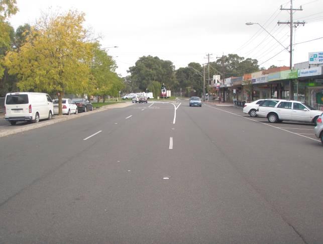
5 LIST OF FIGURES Figure 1: Locality Plan... 8 Figure 2: Subject Site... 9 Figure 3: Planning Scheme Zoning Map Figure 4: Aerial Photograph Figure 5: Chandler Road View South Figure 6: Chandler Road View North from Railway Figure 7: Hanna Street View East Figure 8: Chandler Road View North Figure 9: Chandler Road View South from Eden Court Figure 10: Hanna Street View West Figure 11: Hanna Street View East from Chandler Road Figure 12: Douglas Street View East Figure 13: Railway Parade View East Figure 14: Douglas Street View West from Chandler Road Figure 15: Douglas Street View West Figure 16: Railway Parade View West Figure 17: Existing Peak Hour Traffic Conditions Figure 18: Sidra Intersection Layout Figure 19: Public Transport Map Figure 20: Expected Development Traffic Distribution - Outbound Figure 21: Expected Development Traffic Distribution - Inbound Figure 22: Predicted Development Traffic Volumes (to be added) Figure 23: Predicted Existing Warehouse Volumes (to be deducted) Figure 24: Predicted Post-Development Traffic Volumes on Road Network LIST OF TABLES Table 1: EXISTING CONDITIONS - Analysis of Intersection Performance, Chandler Rd/Hanna St/Douglas Pde Table 2: Operating Characteristics of Chandler Road Level Crossing Table 3: Casualty Crash History Table 4: Estimated Traffic Generation for Residential Zone Table 5: Estimated Traffic Generation for Industrial Zone Table 6: POST-DEVELOPMENT - Change in Intersection Performance AM Peak Hour Table 7: POST-DEVELOPMENT - Change in Intersection Performance PM Peak Hour Table 8: POST DEVELOPMENT - Change in Intersection Performance with Modified Signal Phasing AM Peak Hour.. 32 Table 9: ABS car ownership statistics (2006 Census) R#1 Page 5
6 LIST OF APPENDICES APPENDIX A: EXISTING CONDITIONS SIDRA PHASING SUMMARY APPENDIX B: EXISTING TRAFFIC CONDITIONS - SIDRA RESULTS APPENDIX C: IMPACT OF DEVELOPMENT TRAFFIC - SIDRA RESULTS APPENDIX D: SIDRA RESULTS OF MINOR CHANGES TO GREEN TIME ALLOCATION (AM PERIOD) 14034R#1 Page 6
7 1. INTRODUCTION Traffix Group has been engaged by Yarraman Park Developments to prepare a traffic impact assessment report the proposed rezoning Hanna Street, Noble Park from an Industrial 1 Zone (IN1Z) to a Residential 1 Zone (R1Z). 2. PROPOSAL The proposal is to rezone the subject land at Hanna Street, Noble Park, from an Industrial 1 Zone to a Residential 1 Zone. Whilst there is no development proposal before Council for this land, the proposed rezoning can be expected to accommodate a development yield of approximately 250 dwellings. The majority of dwellings are expected to be attached townhouse style dwellings and a smaller number of apartments. A mixture of one two and three bedroom dwellings is expected. Vehicle access to the site will be provided solely to Hanna Street. 3. EXISTING CONDITIONS 3.1. Development Site The development site is located at the south-eastern end of Hanna Street, opposite Yarraman Railway Station. A locality plan and photograph of the site are presented at Figure 1 and Figure 2, respectively. The site is made up of a number of properties along Hanna Street. The combined site is irregular in shape and has a total area of approximately 4.3ha and a frontage to Hanna Street of approximately 350m. The current uses of the site are listed below: & Hanna Street is occupied primarily by two large warehouse buildings tenanted by AstralPool, a supplier of pool equipment and accessories , 130 & 146 Hanna Street are currently vacant. 134 Hanna Street provides a cycle path through the site between Hanna Street and Mile Creek at the site s southern boundary. Access to the site is provided via a number of single and double width crossovers along the site s Hanna Street frontage. The subject site is located within an Industrial 1 Zone under the Planning Scheme as presented at Figure 3. Land use within the immediate vicinity of the subject site is primarily residential, although there are some industrial uses located south of the site across Mile Creek. A small group of shops is located on Railway Parade which provide a variety of local services, including a milkbar, bakeries, hairdressers, butchers, a fruit and veg shop, takeaway food shops, a dentist, a laundrette and a variety of other small businesses. Other major land uses in the surrounding area are outlined as follows: EastLink Tollway and Eastlink Trail, located adjacent to the site s eastern boundary, Yarraman Railway Station, located opposite the site in Hanna Street, Chandler Road Medical Centre/Pharmacy, located close to the corner of Hanna Street and Chandler Road, 14034R#1 Page 7
 is located approximately 2.5km walking distance south-east of the site.")
8 Greaves Reserve, located on the eastern side of EastLink, and Noble Park Secondary College, located approximately 800m north-west of the site, The Noble Park Activity Centre is located walking distance 1.3km north-west of the site. The Dandenong Central Activities District (CAD) is located approximately 2.5km walking distance south-east of the site. Subject Site Figure 1: Locality Plan Reproduced with Permission of Melways Publishing Pty Ltd 14034R#1 Page 8

9 Subject Site Figure 2: Subject Site Source: Google Earth 14034R#1 Page 9


10 Subject Site Figure 3: Planning Scheme Zoning Map Source: Planning Scheme Maps Road Network Hanna Street is a local road aligned in a north-west to south-east direction between Chandler Road in the north-west and a dead end at EastLink in the south-east, adjacent to the subject site. Hanna Street has a carriageway width of approximately 10.35m, which provides for a through traffic lane in each direction with kerbside parking on both sides of the road. On-street parking along Hanna Street is unrestricted. Indented, 90 parking is available adjacent to Yarraman Railway Station, opposite the existing warehouse uses on the site. Footpaths are provided on both sides of Hanna Street. The default 50km/h urban speed limit applies to Hanna Street R#1 Page 10
11 Chandler Road is a VicRoads Arterial Road, declared under the Road Management Act 2004 and is located within a Category 1 Road Zone under the Planning Scheme. Chandler Road is aligned in a north-south direction between Princes Highway in the north and Church Road in the south Traffic volume data obtained from VicRoads indicates that Chandler Road carries approximately 15-16,400vpd. In the vicinity of the subject site, Chandler Road has a carriageway width of approximately 12.6m, which provides for two traffic lanes in each direction. Parking in the kerbside lane is generally unrestricted. A speed limit of 60km/h applies to Chandler Road. Douglas Street is a Council Arterial Road and Road Zone Category 2 under the Planning Scheme. Douglas Street is aligned in a north-west to south-east direction between Heatherton Road in the north and Chandler Road in the south. Douglas Street typically provides a single traffic lane in each direction. Near its intersection with Chandler Road, Douglas Street provides two eastbound and one westbound traffic lanes. A speed limit of 60km/h applies to Douglas Street. Railway Parade is a Council Arterial Road and Road Zone Category 2 under the Planning Scheme. Railway Parade is aligned in the north-west to south-east direction between Chandler Road in the north and George Street in the south, where it continues as Foster Street. Railway Parade typically provides a single traffic lane in each direction. Indented, angled parking is provided along the frontages of the commercial buildings of the local shopping centre. A 60km/h speed limit applies to Railway Parade. All of the above streets form a large signalised intersection, divided by the Dandenong railway line. Right turn movements from Chandler Road in Douglas Street are prohibited for southbound traffic on Chandler Road. The signal phasing allows traffic from Railway Parade to continue through to Douglas Parade via a staggered through movement. An aerial photograph of the intersection between Chandler Road, Railway Parade, Douglas Street and Hanna Street is provided at Figure 4 Photographs of the surrounding road network are provided at Figure 5 and Figure R#1 Page 11

12 Figure 4: Aerial Photograph Source: Google Earth 14034R#1 Page 12


13 Figure 5: Chandler Road View South Figure 6: Chandler Road View North from Railway Figure 7: Hanna Street View East Figure 8: Chandler Road View North Figure 9: Chandler Road View South from Eden Court Figure 10: Hanna Street View West 14034R#1 Page 13


14 Figure 11: Hanna Street View East from Chandler Road Figure 12: Douglas Street View East Figure 13: Railway Parade View East Figure 14: Douglas Street View West from Chandler Road Figure 15: Douglas Street View West Figure 16: Railway Parade View West 14034R#1 Page 14
15 3.3. Existing Traffic Conditions Traffix Group has undertaken turning movement counts at the intersections of: Chandler Road, Hanna Street and Douglas Street, and Chandler Road and Railway Parade. The counts were undertaken between 7am-9am and 4pm-6pm on Thursday 29 th March, The peak hour traffic volumes recorded during the surveys are presented in Figure 17 below. The peak hours were identified as 8am-9am for the AM peak hour and 4:45pm-5:45pm for the PM peak hour. LEGEND Traffic Volumes AM Peak Hour 8am-9am (PM Peak Hour 4:45pm- 5:45pm) Road Traffic Xing Closures CHANDLER ROAD 400 (438) 25 (53) 88 (119) 387 (558) North 140 (212) 424 (479) 134 (174) RAILWAY PARADE 12 (16) 378 (531) 104 (170) 13 (11) 65 (111) 95 (151) 414 (485) 27 (20) CHANDLER ROAD HANNA STREET DOUGLAS STREET 30 (41) 27 (14) 6 (15) 111 (103) 74 (74) 448 (416) 8 (2) Figure 17: Existing Peak Hour Traffic Conditions Based on the rule of thumb that 10% of the daily traffic volumes occur during the peak hour, the estimated daily traffic volumes for the surveyed local roads are: Hanna Street 1,000-1,100vpd Douglas Street 3,800-5,300vpd Railway Parade 3,900-5,600vpd 14034R#1 Page 15

16 Traffix Group has sourced SCATS traffic data from VicRoads that indicates Chandler Road carries approximately 16,400 vehicles per weekday Analysis of Existing Traffic Conditions Sidra Intersection 5.1 has been used to model the performance of the intersection between Chandler Road, Hanna Street and Douglas Street. The assessment of the intersection s performance was made on the basis of the traffic volumes presented in Figure 17. The following intersection layout has been adopted, as presented in Figure 18. The layout adopts two, 2.5m wide traffic lanes for the Hanna Street approach to the intersection, although only one lane is currently linemarked. In practice, it was observed that drivers regularly formed two queues at Hanna Street. This is likely a result of the majority of vehicles using Hanna Street being associated with local employees or residents, who are familiar with the operation and layout intersection (given that Hanna Street is not a through road). Railway Level Crossing Figure 18: Sidra Intersection Layout In order to accurately model the intersection, SCATS and IDM data for the survey day on the 29 th March, 2012 has been sourced from VicRoads. This assessment allows for: The phases times used in the analysis are based on the actual phase time proportions that ran during the survey times between 7am-9am and 4pm-6pm on Thursday 29 th March, By 14034R#1 Page 16
17 specifying the phase times that ran on the survey day, the effects of the railway level crossing closures can be accurately included in the model. The phase diagrams are attached at Appendix A of this report. The results obtained from Sidra correlated well with the queue lengths and delays observed during the survey. The peak hour traffic volumes and the percentage of heavy vehicles for each movement were sourced from the turning movement surveys (refer to Figure 17). The intersection capacity analysis allows estimation of key operating parameters such as intersection degree of saturation (DoS), average delay and 95 th percentile queue lengths, which are described below: Degree Of Saturation (DoS) measure of intersection performance expressed as a ratio of demand/capacity. A DOS greater than 0.95 is generally regarded as unsatisfactory for a signalised intersection, see shown in the table below. Level of Service Intersection Degree of Saturation Unsignalised Intersection Signalised Intersection A Excellent <= 0.60 <= 0.60 B Very Good C Good D Acceptable E Poor F Very Poor >= 1.0 >= th Percentile Queue Length (m) one car represents a 7m queue Average delay - no. of seconds delayed The Sidra assessment results are set out in the table below for the for the AM and PM peak periods. The AM peak period is the critical period due to the higher number of movements seeking to exit the site in this period. Appendix B provides the Sidra output summary for this analysis. Based on the analysis below, all legs of the Chandler Road/Hanna Street/Douglas Street intersection operate at LOS A, except for southern approach of Chandler Road, which operates at LOS B during the AM peak hour. The average queue lengths and delays correspond well to our on-site observations. The length of the queues for all approaches to the intersection is heavily influenced by the duration of any railway level crossing closure, which is dependent on the number of trains and whether trains are express or stopping R#1 Page 17
18 Table 1: EXISTING CONDITIONS - Analysis of Intersection Performance, Chandler Rd/Hanna St/Douglas Pde Intersection Approach Movement Demand (veh/h) Degree of Sat. LOS 95th %-ile Queue (veh) Average Delay (sec) AM Peak Hour Chandler Road: North Chandler Road: South Left-Turn A Through A Right A Left-Turn A 1 9 Through B Right B Hanna Street Left-Turn A 1 27 Through A 1 19 Right A 3 88 Douglas Street Left-Turn A 8 77 PM Peak Hour Chandler Road: North Chandler Road: South Through A 3 21 Right A 3 27 Left-Turn A Through A Right A Left-Turn A 1 10 Through A Right A Hanna Street Left-Turn A 1 32 Through A 1 24 Right A 3 86 Douglas Street Left-Turn A Through A 6 27 Right A Level Crossing Performance Observations were also made of the operating characteristics of the Chandler Road level crossing over the course of the traffic surveys. A total of 38 trains were recorded during the 2 hour AM survey period and 36 during the 2 hour PM survey period R#1 Page 18
19 A total of 17 passing trains were recorded in the AM peak hour (8am-9am), which related to 12 closures. A total of 19 passing trains were observed in the PM peak hour (4:45pm-5:45pm), which related to 16 closures. The surveys also recorded the following information: The total number of trains through the level crossing, The duration the railway crossing closure (i.e. lights flashing/gates down), and The duration that a red signal was displayed to traffic on Chandler Road before and after a train passed through the level crossing. A summary of the operating characteristics of the level crossing is provided in the table below. It should be noted that the traffic signals at the level crossing include a clearance phase to allow traffic on Chandler Road to clear the level crossing before the boom gates are lowered. This phase reduces the green time available to through traffic on Chandler Road (compared to just the level crossing closure time). Table 2: Operating Characteristics of Chandler Road Level Crossing AM Peak PM Peak Characteristic Duration of Level Crossing Closure Duration Red Signal* is displayed in Chandler Road Duration of Level Crossing Closure Duration Red Signal* is displayed in Chandler Road Minimum 0:00:40 0:00:56 0:00:36 0:00:40 Maximum 0:06:42 ** 0:07:06** 0:02:30*** 0:03:13*** Average 0:01:24 0:02:16 0:01:03 0:01:37 Total (over 2 hours) Total (over Peak Hour) *Note: During a level crossing closure event only ** Relates to 5 passing trains in single closure. *** Relates to 2 passing trains in single closure. 0:34:58 0:58:52 0:29:22 0:43:51 0:14:16 0:22:41 0:15:00 0:24:56 Our surveys observed that the procedure known as 'express-stopper' selection is not in use at the Chandler Road level crossing adjacent to Yarraman Railway Station. For the signalling of levels crossings with an adjacent station, a differentiation is made to cater for stopping and express trains as a means of reducing the road closure time and associated delays to road-based traffic. This process is generally referred to as stopper selection, which delays the signal activation for stopper trains when a train will be stopped at a station on approach to a level crossing and reduces the overall level crossing closure time. Stopper selection only applies for trains stopping on the station side of the level crossing, which would be citybound trains at Yarraman Station. As the system default is to classify all trains as express trains, the signalperson is required to identify a stopper train by selecting the signal manually. The implications of not correctly identifying stopper trains are longer level crossing closure times as longer warning times occur in advance of a train traversing the level crossing (usually an additional seconds per closure depending on the dwell time at the station). The use of stopper selection has been the subject of much debate by road and rail authorities. The reasons put forward as to why train operators do not implement stopper selection relates to train driver preference to face fewer red signals, which in turn leads to reduced late running of trains and reduced driver stress (noting that drivers are fined if they run a red signal, which can also be a significant union 14034R#1 Page 19
20 issue). The reasons in favour for properly implementing stopper selection are reduced delays to road traffic (including road-based public transport services) and pedestrians seeking to use the level crossing. Our investigations indicate that the proper implementation of stopper selection would improve the operation of this level crossing and signalised intersection as an additional seconds would be gained when the level crossing is closed for citybound trains Road Safety Review A review of road casualty crash statistics for the past 5 years of available data (1 st January, 2006 to 31 st December, 2010) 1 has been undertaken for the nearby area. The crash investigation area included the length of Hanna Street and the Chandler Road/Hanna Street/Douglas Street/Railway Parade intersection. The review indicates that there have been 12 casualty crashes reported at the intersection of Chandler Road/Hanna Street/Douglas Street/Railway Parade, which includes a range of locations and crash types. A summary of the reported casualty crashes is provided in Table 3. The reported casualty crashes indicate a significant number of right turn crashes involving vehicles turning right into Douglas Street that fail to give way to northbound traffic on Chandler Road. Right turn movements have been recently prohibited for southbound traffic on Chandler Road into Douglas Street, which would have been implemented to address this issue. A fully controlled right turn remains permitted for traffic from Railway Parade to continue through to Douglas Street. The recorded crashes involving movements to/from Hanna Street do no exhibit any particular road safety pattern and we are satisfied that this aspect of the intersection does not have an existing road safely issue. Table 3: Casualty Crash History Location Date Time Severity Chandler Rd & Douglas St Chandler Rd & Hanna St Mon 19/11/07 Fri 13/08/10 Sat 29/07/06 Tue 25/11/08 Mon 16/07/07 S 13/12/08 Sun 02/04/06 Type (DCA code) 13:20 OI :00 OI :30 SI :25 SI :59 OI :00 OI :00 SI 121 Type of Accident Cross Traffic. Car travelling south on Chandler Road collides with eastbound cyclist Right Through. Car turning right into Douglas Street collides with northbound vehicle on Chandler Road Right Through. Car turning right into Douglas Street collides with northbound vehicle on Chandler Road Right Through. Car turning right into Douglas Street collides with northbound vehicle on Chandler Road Right Through. Car turning right into Douglas Street collides with northbound vehicle on Chandler Road Right Through. Car turning right into Douglas Street collides with northbound vehicle on Chandler Road Right Through. Car turning right into Hanna Street collides with southbound vehicle on Chandler Road 1 Casualty crash data is contained in the VicRoads Crashstats Internet Database and includes all reported casualty crashes (i.e. injury crashes), which are classified into Fatal Injury, Serious Injury and Other Injury (i.e. minor injury) crashes. Property damage only or noninjury crashes are not included in the database 14034R#1 Page 20
21 Location Date Time Severity Chandler Rd & Railway Pde Thu 09/07/09 Fri 24/10/08 Fri 21/12/07 Fri 02/10/09 Wed 05/03/08 Type (DCA code) 11:45 OI :00 SI :00 SI :00 SI 173 (M) 15:35 SI 174 (M) Type of Accident Left of Carriageway. Car turning left into Hanna Street fails to make turn and collides with pole Left Near Collision. Car exit Hanna St collides with southbound vehicle on Chandler Road which ran red light Right off Carriageway. Car exiting Hanna Street collides with traffic signals Right off Carriageway. Motorcyclist exiting Hanna Street falls off bike into kerb. Out of Control on Carriageway. Motorcyclist travelling north on Chandler Road loses control trying to avoid a car changing lanes suddenly LEGEND: OI: Other Injury SI: Serious Injury F: Fatality (B): Bicyclist (M): Motorcyclist (P): Pedestrian (C): Bus/Coach (RT): Rigid Truck (ST): Semi-trailer 3.4. Public Transport Facilities and Alternative Transport Modes The site is well served by local public transport services with train and bus services located in close proximity to the site. The public transport network surrounding the site is presented in Figure 19. The available public transport services in the immediate area are detailed as follows: Yarraman Station is located opposite the subject site in Hanna Street. Yarraman Station is located on the Pakenham and Cranbourne Lines and provides a convenient connection to the CBD. Bus Route 812 operates along Railway Parade within 50m of the subject site and provides a service between Dandenong and Brighton via Parkmore Shopping Centre. Bus Route 813 operates along Railway Parade within 50m of the subject site and provides a service between Dandenong and Waverley Gardens Shopping Centre via Parkmore Shopping Centre. Bus Route 815 operates along Railway Parade within 50m of the subject site and provides a service between Dandenong and Noble Park via Parkmore Shopping Centre R#1 Page 21

22 Subject Site Figure 19: Public Transport Map Source: Metlink, R#1 Page 22
23 4. TRAFFIC IMPACTS The following presents an assessment of the predicted traffic impact of the proposed rezoning from an Industrial to Residential zone. Whilst there is no development proposal before Council for this land, the proposed rezoning can be expected to accommodate a development yield of approximately 250 dwellings. The assessment assumes that a mixture of one, two and three bedroom dwellings would be provided. At this stage, the majority of dwellings are expected to be townhouse style dwellings or similar with a smaller number of apartments. The above level of development on the site has been adopted for planning purposes only, in order to assess the likely traffic impacts of the rezoning. The ultimate number and type of dwellings to be provided on the site would be determined at a later date as part of a separate town planning process Traffic Generation Rates Given the level of public transport accessibility and likely mix of 1, 2 and 3 bedroom dwellings within the subject land, the proposed dwellings are expected to generate in the order of 4 to 8 vehicle trip ends per dwelling per day, with trip ends per dwelling in each of the peak hours. 2,3 In the absence of more detailed information on the dwelling mix, target market for each building and carparking provision levels, the adoption of the follow rates is appropriate for this stage of the planning process: 6 vehicle trip ends per dwelling, per day, and 0.6 vehicle trip ends per dwelling per peak hour. There may be cases where lesser rates are appropriate, such as where a particular development is targeted as an affordable housing development (which may include low rates of car parking provision and/or small household sizes e.g. studio apartments), or a particular demographic that may have low car ownership (e.g. older persons, student accommodation) or is provided as a social housing development. A summary of the predicted traffic generation for uses within the subject land is presented at Table 4. Table 4: Estimated Traffic Generation for Residential Zone Land-Use No. Peak Hour Traffic Generation Daily Traffic Generation Rate Veh/hour Rate Veh/day Dwellings per dwelling per dwelling per day 1,500 This compares to the expected traffic generated by a typical industrial use of the land, adopting the typical rates set out in the RTA Guide to Traffic Generating Developments. The RTA Guide specifies: A warehouse use as generating: Daily vehicle trips 4 per 100m 2 GFA, and Morning vehicle trips 0.5 per 100m 2 GFA. 2 Residential traffic generation rates for flats or units is typically in the range of 3 to 5 vehicle trip ends per dwelling per day. Residential traffic generation rates for dwellings in middle suburbs is typically in the range of 5 to 8 vehicle trip ends per dwelling per day (Traffic Engineering & Management, K.W. Ogden and S.Y. Taylor-2003, pp ). 3 The RTA Guide to Traffic Generating Developments (Version 2.2, October, 2002) recommends a rate of 4 to 5 vehicle trip ends per dwelling per day, with a peak hour volume of 0.4 to 0.5 vehicle trip ends per dwelling for smaller units and flats with up to 2 bedrooms, and 5 to 6.5 vehicle trip ends per dwelling per day, with a peak hour volume of 0.5 to 0.65 vehicle trip ends per dwelling for larger units and town houses with 3 or more bedrooms R#1 Page 23
24 A factory use as generating: Daily vehicle trips 5 per 100m 2 GFA, and Morning vehicle trips 1 per 100m 2 GFA. The table below assess the potential industrial traffic generation for the 4.3ha site, assuming 60% building area is achieved on the site (i.e. 26,000m 2 of GFA). Table 5: Estimated Traffic Generation for Industrial Zone Land-Use Size Peak Hour Traffic Generation Daily Traffic Generation Rate Veh/hour Rate Veh/day Warehouse 0.5 per 100m per 100m 2 1,040 26,000m 2 Factory 1 per 100m per 100m 2 1,300 An industrial use of the land would be expected to include a mix of warehouse and factory uses, which would generate a level of traffic within the range detailed in this table. Accordingly, this level of traffic is not dissimilar to a residential use of the land, albeit a residential use would generate a much lower proportion of commercial traffic Traffic Distribution Model The site will have sole access to Hanna Street and consequently, all of the development traffic will access the site through the intersection of Hanna Street with Chandler Road and Douglas Street. The traffic distribution model considers the layout of the surrounding road network (location and direction of arterial roads and freeways) and the likely destinations for vehicles arriving and departing from the subject land (Dandenong CAD and the industrial areas to the south-east such as Springvale, Clayton, etc.). The following assumptions have been adopted for the traffic distribution model for the subject land: Development traffic departing the site through the Chandler Road/Hanna Street/Douglas Street/Railway Parade intersection is expected to be split between the north-south-east-west on a basis. It is acknowledged that a proportion of traffic will ultimately head east from the site, and this traffic will be split between the traffic departing to the north and south along Chandler Road. Development traffic arriving at the Chandler Road/Hanna Street/Douglas Street/Railway Parade intersection is expected to be split between the north-south-east-west on a basis. As above, some additional traffic that arrives from the east of the site will approach the intersection from the north or south along Chandler Road. The proportion of traffic travelling to and from the north takes into account the high level of arterial and freeway road access available to the north (i.e. Princes Highway, Eastlink and the Monash Freeway are all available to the north of the site). Based on our previous experience with similar residential uses, the distribution of peak hour traffic is expected to be split: o 20% inbound and 80% outbound in the AM Peak, and o 70% inbound and 30% outbound in the PM peak. The predicted traffic distribution for the AM and PM peak hours is provided in Figure 20 and Figure 21, respectively. Figure 22 outlines the peak hour traffic volumes generated by the development R#1 Page 24
25 The existing traffic volumes recorded for this intersection include traffic generated by the existing industrial use of the land. Part of the subject land is occupied by Astralpool (a pool supplies and accessories warehouse), which will be removed following the rezoning. This business occupies two existing warehouse buildings on the site, which have a combined floor area of approximately 9,500m 2. An assessment has been made of the existing traffic generation using the RTA Guide to Traffic Generating Developments, which specifies a warehouse use as generating: Daily vehicle trips 4 per 100m 2 GFA, and Morning vehicle trips 0.5 per 100m 2 GFA. Our enquiries with Astralpool indicate that staff typically arrive early and depart before that traditional AM and PM peak hours, respectively due to the shift nature of their work. The business employs approximately 200 staff who work shifts over a 24 hour period (with approximately 100 staff working the day shift). Accordingly, a peak hour generation of half the rate specified in the RTA Guide has been adopted in this assessment (i.e vehicle trips per 100m 2 GFA). These rates equate to a daily traffic generation rate of 380 vehicles per day and 24 vehicle trips per peak hour (which is consistent with the observations in the surveys for this use). The evening traffic generation rate has been assumed to be the same as the morning traffic generation rate. For the purposes of this analysis, we have assumed that the warehouse traffic is distributed 80/20 between arrivals and departures in the AM peak hour and 20/80 in the PM peak hour. This traffic needs to be subtracted from the existing traffic volumes to produce the base case, which each movement reduced proportionally based on its existing volumes. This existing warehouse traffic distribution is shown in Figure 23. Figure 24 shows the expected peak hour post-development traffic volumes for the nearby road network. This figure has been based on the existing peak hour traffic volumes presented at Figure 17, with the addition of the development traffic (presented at Figure 22) and a reduction in traffic as a result of removing the existing warehouse use (Figure 23) R#1 Page 25
26 SUBJECT SITE SUBJECT SITE Legend Traffic Destination North East South West Legend Traffic Destination North East South West Reproduced with Permission of Melways Publishing Pty Ltd Figure 20: Expected Development Traffic Distribution - Outbound Reproduced with Permission of Melways Publishing Pty Ltd Figure 21: Expected Development Traffic Distribution - Inbound 14034R#1 Page 26
27 Hanna Street, Noble Park Legend Inbound Outbound Traffic Volumes AM Peak Hour (PM Peak Hour) CHANDLER ROAD 14 (47) North Legend Inbound Outbound Traffic Volumes AM Peak Hour (PM Peak Hour) CHANDLER ROAD 11 (3) North 3 (10) 0 (0) 54 (20) 0 (0) RAILWAY PARADE 2 (11) 0 (0) RAILWAY PARADE 9 (32) 17 (57) 5 (2) 11 (3) CHANDLER ROAD HANNA STREET DOUGLAS STREET 2 (11) 2 (4) 1 (4) 19 (5) 5 (19) 3 (0) CHANDLER ROAD HANNA STREET DOUGLAS STREET 54 (20) 36 (14) 30 (11) 30 (105) 120 (45) 4 (16) Figure 22: Predicted Development Traffic Volumes (to be added) Figure 23: Predicted Existing Warehouse Volumes (to be deducted) 14034R#1 Page 27
28 LEGEND Traffic Volumes AM Peak Hour 8am-9am (PM Peak Hour 4:45pm- 5:45pm) Road Traffic Crossing Closures CHANDLER ROAD 403 (482) 25 (53) 88 (119) 390 (568) North 143 (222) 476 (488) 134 (174) RAILWAY PARADE 12 (16) 382 (561) 104 (170) 17 (41) 65 (111) 95 (151) 414 (485) 33 (74) CHANDLER ROAD HANNA STREET DOUGLAS STREET 82 (50) 61 (24) 35 (22) 237 (229) 74 (74) 448 (416) 9 (18) Figure 24: Predicted Post-Development Traffic Volumes on Road Network 4.3. Traffic Impacts Sidra 5.1 has been used to model the effects of the development traffic on the intersection of Chandler Road/Hanna Street/Douglas Street. For the initial assessment: Development traffic was added to the model. No changes were made to the configuration of the intersection or the signal phasing at this stage. The percentage of commercial vehicles to/from Hanna Street has been reduced to 3%. The surveys undertaken by Traffix Group recorded a significantly higher percentage of commercial vehicles (based on significantly lower total traffic volumes). The reduction is appropriate as following the rezoning, there will no longer be any industrial uses within Hanna Street and commercial traffic to the dwellings will relate to service vehicles only. The Sidra assessment results are set out in Table 6 and Table 7 for the for the AM and PM peak periods, respectively. Appendix C provides the detailed Sidra output for this analysis R#1 Page 28
29 Table 6: POST-DEVELOPMENT - Change in Intersection Performance AM Peak Hour Intersection Approach Movement Expected Intersection Conditions Change in Intersection Performance from Existing Conditions Demand (veh/h) Degree of Sat. LOS 95th %-ile Queue (veh) Average Delay (sec) Demand (veh/h) Degree of Sat. LOS 95th %-ile Queue (veh) Chandler Road: North Left A Through A Right A Chandler Road: South Left A Through B Right B Hanna Street Left A Through A Right E A to E 5 27 Douglas Street Left A Through A Right A Average Delay (sec) 14034R#1 Page 29
30 Hanna Street, Noble Park Table 7: POST-DEVELOPMENT - Change in Intersection Performance PM Peak Hour Intersection Approach Movement Expected Intersection Conditions Change in Intersection Performance from Existing Conditions Demand (veh/h) Degree of Sat. LOS 95th %-ile Queue (veh) Average Delay (sec) Demand (veh/h) Degree of Sat. LOS 95th %-ile Queue (veh) Chandler Road: North Left A Through A Right A Chandler Road: South Left A Through C A to C 6 7 Right C A to C Hanna Street Left A Through A Right B A to B 1 3 Douglas Street Left A Through A Right A Average Delay (sec) 14034R#1 Page 30
31 Based on the analysis above, the following key traffic impacts would occur as a result of the proposed rezoning: AM Peak Hour No significant changes are expected for the operating conditions for all approaches to the intersection, except for Hanna Street. The right turn movement from Hanna Street is the critical movement with a DOS of (LOS E), an average delay of 115 seconds and a 95 th percentile queue of 8 vehicles. All other approaches to the intersection are expected to experience only minor additional delays or queues. PM Peak Hour During the PM peak hour, the most affected movements are: o Right turn movements from Hanna, although with lower delays than expected during the AM peak hour with a DOS of (LOS B), an average delay of 89 seconds and a 95 th percentile queue of f vehicles. o Through and right turn movements on the southern approach of Chandler Road with the DOS increasing by and the LOS decreasing from A to C. This is primarily due to the increase in right turn movements into Hanna Street. Other than right turn movements from Hanna Street during the AM peak, we are satisfied that the proposed traffic impacts of the development are acceptable in both the AM and PM peak hour, given that none of the intersection movements (other than Hanna Street) will operate with a LOS of higher than C and a DOS of greater than (i.e. representing good operating conditions). The one exception to the above is for the delays imposed on traffic turning right from Hanna Street during the AM peak hour. As noted above, the Sidra assessment indicates a DOS of (LOS E), an average delay of 115 seconds and a 95 th percentile queue of 8 vehicles. A DOS of E is regarded as poor and would warrant a review of the signal timings Potential Mitigating Treatments The potential impacts of the development traffic could be mitigated by altering the signal green time allocated to Hanna Street. It can be reasonably expected that the signal phase times would be slightly adjusted in order to accommodate any significant increase in traffic accessing Hanna Street as a result of the rezoning of this land. The same would also apply had any further industrial development of the land occurred, which would be expected to generate a similar level of traffic as a residential use (as set out previously in Table 5). Further analysis indicates that even a small increase in the green time allocated to phase C (the phase permitting right turn traffic from Hanna Street) would significantly lower the delays and queues within Hanna Street, with minimal impact on through traffic in Chandler Road. This alteration to the green time for phase C is only required in the AM peak hour when traffic leaving the development will be at its peak. The effects of increasing the green time allocated to Hanna Street from 11 seconds to 14 seconds per cycle and are provided at Table 8 with the Sidra output attached at Appendix D. This represents the difference in the post-development performance conditions for the case with and without altering the Hanna Street green time R#1 Page 31
32 Table 8: POST DEVELOPMENT - Change in Intersection Performance with Modified Signal Phasing AM Peak Hour Intersection Approach Movement Intersection Conditions with Modified Signal Phasing Change in Intersection Performance for Post-Development Case with no Alterations to Signal Phasing Demand (veh/h) Degree of Sat. LOS 95th %-ile Queue (veh) Average Delay (sec) Demand (veh/h) Degree of Sat. LOS 95th %-ile Queue (veh) Chandler Road: North Left A Through A Right A Chandler Road: South Left A Through C B to C 1 2 Right C B to C 0 4 Hanna Street Left A Through A Right C E to C Douglas Street Left A Through A Right A Average Delay (sec) 14034R#1 Page 32
33 Based on the table above, we are satisfied that minor alternations to the signal phasing during the AM peak hour would be appropriate to provide adequate access to Hanna Street. It is also recommended that the linemarking within Hanna Street on the approach to Chandler Road be adjusted to formally provide a right turn lane and a separate, shared through and left lane. As noted above, drivers were already observed forming two queues traffic within the single lane provided and this arrangement should be formalised Effects of Railway Level Crossing Traffix Group has contacted the Department of Transport to source information about future increases in rail traffic through the level crossing. The Department of Transport was unable to provide an estimate about the growth in rail traffic along this line as no detailed or reliable information is available at this time. The level crossing imposes significant delays to road traffic, as described in Section The total time a red signal was displayed to through traffic on Chandler Road (during a train crossing event) was 38% of the AM peak hour and 42% of the PM peak hour. Our surveys observed that the procedure known as 'express-stopper' selection is not in use at the Chandler Road level crossing adjacent to Yarraman Railway Station. Our investigations indicate that the proper implementation of stopper selection would improve the operation of this level crossing and signalised intersection as an additional seconds would be gained when the level crossing is closed for citybound trains. This is significant in the context that the level crossing closes 12 to 16 times for trains per peak hour. This would have the benefit of reduced delays to road traffic (including road-based public transport services) and pedestrians using the level crossing. It is recommended that Council and VicRoads pursue the use of stopper selection with train operators for this station Daily Traffic Impacts The generally accepted environmental capacity of an Access Street Level 2 such as Hanna Street is 3,000 vehicles per day as set out in Clause of the Greater Dandenong Planning Scheme. Based on the traffic counts presented at Section 3.3, Hanna Street carries approximately 1,000-1,100 vehicles per day (which includes the existing warehouse/industrial traffic). Accordingly, the impact of an additional 1,500 vehicles per day generated by the development is such that traffic volumes within Hannah Street will remain within the acceptable limits for this street. This assessment does not take into account the existing traffic generated by the existing industrial buildings on the site and as such, the actual increase in traffic volumes on Hanna Street will be less than 1,500 vehicles per day. The site has convenient access from Hanna Street to the arterial road network and has no connections to other local streets. As a result, there is unlikely to be any impact from development traffic on nearby local streets Summary of Traffic Impacts Following our detailed analysis, we are satisfied that the traffic generated by the proposed development will not have a significant impact on the intersection of Chandler Road/Hanna Street/Douglas Street. As a result of the additional development traffic, small increases delays and queues are expected at the intersection, except for right turning traffic from Hanna Street during the AM peak hour. It was found that minor changes to the signal phasing at the Hanna Street/Chandler Road intersection would significantly reduce the delays associated with this movement. As a result of these chances, all movements would continue to operate with a good level of service (LOS C). It is recommended that linemarking changes are implemented on the Hanna Street approach to the intersection in order to formalise the provision of separate right turn and through/left traffic lanes R#1 Page 33
34 The investigations have also found that significant additional delays are imposed on road traffic through the level crossing by trains stopping at Yarraman Station, where stopper selection is not used by train operators. The proposed daily traffic generation by the development within Hanna Street will not exceed the environmental capacity of Hanna Street. 5. ASSESSMENT OF PARKING DEMANDS 5.1. Statutory Parking Rates The proposed use of the subject land falls within the land-use category of dwelling under Clause 74 of the Planning Scheme. The Planning Scheme sets out the parking requirements for new developments under Clause The purpose of Clause is: To ensure that car parking is provided in accordance with the State Planning Policy Framework and Local Planning Policy Framework. To ensure the provision of an appropriate number of car parking spaces having regard to the demand likely to be generated, the activities on the land and the nature of the locality. To support sustainable transport alternatives to the motor car. To promote the efficient use of car parking spaces through the consolidation of car parking facilities. To ensure that car parking does not adversely affect the amenity of the locality. To ensure that the design and location of car parking is of a high standard, creates a safe environment for users and enables easy and efficient use. Table 1 of Clause requires car parking for dwellings to be provided at the following rates. Table 9: Statutory Carparking Requirement: Clause Use One-Bedroom Dwelling Two-Bedroom Dwelling Three or more Bedroom Dwelling Statutory Park Rate (Column A) 1 spaces per dwelling 2 spaces per dwelling Visitor 1 space per every 5 dwellings (1) *Note: Practice Note 22 (June, 2012) specifies that where a car parking calculation results in a requirement that is not a whole number, the number of spaces should be rounded down to the nearest whole number R#1 Page 34
PROPOSED RESIDENTIAL SUBDIVISION
 PROPOSED RESIDENTIAL SUBDIVISION PART OF TARNEIT ROAD & 1121 DOHERTYS ROAD, TARNEIT Prepared For: TCG (RM) Developments Pty Ltd MARCH 2014 OUR REF: 16740R#1 PROPOSED RESIDENTIAL SUBDIVISION PART OF TARNEIT
BROMPTON LODGE, CRANBOURNE PRECINCT STRUCTURE PLAN TRAFFIC ENGINEERING ASSESSMENT WOLFDENE PTY LTD PREPARED FOR
 BROMPTON LODGE, CRANBOURNE PRECINCT STRUCTURE PLAN TRAFFIC ENGINEERING ASSESSMENT PREPARED FOR WOLFDENE PTY LTD TRAFFIC ENGINEERING ASSESSMENT PRECINCT STRUCTURE PLAN AT BROMPTON LODGE, CRANBOURNE Document
Traffic and Transport Assessment
 Traffic and Transport Assessment Section 96 Residential Subdivision, Davis Road Tarneit CG120370 Prepared for Stockland Pty Ltd 19 February 2013 Document Information Prepared for Stockland Pty Ltd Project
Traffic Engineering Assessment. Additional Traffic Modelling at Minta Farm PSP 11. Prepared for Victorian Planning Authority
 Additional Traffic Modelling at Minta Farm PSP 11 Prepared for Victorian Planning Authority Traffic Engineering Assessment Additional Traffic Modelling at Minta Farm PSP 11 Document Control Issue No. Type
Acland Street, St Kilda
 Acland Street, St Kilda Traffic Redistribution Client: Yarra Trams Project No. 122531 Draft_4 Report 16/09/13 Suite 1, 1 st Floor 132 Upper Heidelberg Road Ivanhoe Vic 3079 PO Box 417 Ivanhoe Vic 3079
Barwon Heads Road, Armstrong Creek Traffic Impact Assessment Prepared for: Newland Developers Pty Ltd
 892 990 Barwon Heads Road, Armstrong Creek Traffic Impact Assessment Prepared for: Newland Developers Pty Ltd JULY 2015 TABLE OF CONTENTS 1 INTRODUCTION... 1 1.1 BACKGROUND... 1 1.2 SCOPE... 1 1.3 AIM
HENDERSON DEVELOPMENT 213, 217, 221, 221 ½, 223 HENDERSON AVENUE and 65 TEMPLETON STREET OTTAWA, ONTARIO TRANSPORTATION OVERVIEW.
 HENDERSON DEVELOPMENT 213, 217, 221, 221 ½, 223 HENDERSON AVENUE and 65 TEMPLETON STREET OTTAWA, ONTARIO TRANSPORTATION OVERVIEW Prepared for: 2294170 Ontario Inc. February 2, 2017 117-652 Report_1.doc
Harriet Fraser Traffic Engineering & Transportation Planning
 Appendix 5: Traffic Assessment 71 26 February 2015 Mr James Beban Senior Resource Consents Planner Cuttriss Consultants Ltd PO Box 30429 Lower Hutt PO Box 40170 Upper Hutt 5140 P 04 526 2979 M 027 668
STATEMENT TO PLANNING PANELS VICTORIA BY WILLIAM DE WAARD, TRAFFIC ENGINEER
 Amendment C228 to the Casey Planning Scheme Traffic Engineering Assessment Planning Panels Victoria Panel Hearing Date: Monday 16 th April, 2018 Report Date: 5 th April, 2018 Prepared for the Applicant:
Ministry of Education Flat Bush School Notice of Requirement. Integrated Transportation Assessment Report. February 2016
 Ministry of Education Flat Bush School Notice of Requirement Integrated Transportation Assessment Report February 2016 TDG Ref: 12988-2 151105 ita flat bush.docx Ministry of Education Flat Bush School
Proposed Residential & Retail Development at Geelong Rd Portarlington
 Batman Invest Traffic Impact Assessment Proposed Residential & Retail Development at 30-32 Geelong Rd Portarlington Batman Invest Traffic & Parking Impact Assessment for Proposed Residential & Retail Development
Kings College, Otahuhu Proposed Plan Change. Integrated Transportation Assessment Report
 Proposed Plan Change Integrated Transportation Assessment Report 23 October 2017 Project: Report title: Document reference: Kings College, Otahuhu Integrated Transportation Assessment Report J00700 Kings
Berwick Health and Education Precinct: Casey Amendment C207 (Part 1) Submission to Planning Panels Victoria
 Submission to Planning Panels Victoria") Berwick Health and Education Precinct: Casey Amendment C207 (Part 1) Submission to Planning Panels Victoria August 2018 CONTENTS 1 Executive summary... 1 2 Summary of the amendment... 2 3 Submission...
Berwick Health and Education Precinct: Casey Amendment C207 (Part 1) Submission to Planning Panels Victoria August 2018 CONTENTS 1 Executive summary... 1 2 Summary of the amendment... 2 3 Submission...
COMMERCIAL DEVELOPMENT 2015 ROBERTSON ROAD OTTAWA, ONTARIO TRANSPORTATION BRIEF. Prepared for:
 COMMERCIAL DEVELOPMENT 2015 ROBERTSON ROAD OTTAWA, ONTARIO TRANSPORTATION BRIEF Prepared for: First Bay Properties Inc. 311 Richmond Road, Suite 203 Ottawa, ON K1Z 6X3 August 8, 2017 117-663 Brief_1.doc
Appendix 5 Traffic Assessment
 Appendix 5 Traffic Assessment 44 Harrison Transportation Best Start Educare Shelly Bay Road Beachlands Transportation Assessment Report September 2017 PO Box 11 557 Palm Beach Papamoa 3151 Reference: 187
INDUSTRIAL BUILDING 3009 HAWTHORNE ROAD CITY OF OTTAWA TRANSPORTATION OVERVIEW REVISED. Prepared for: Canada Inc.
 INDUSTRIAL BUILDING 3009 HAWTHORNE ROAD CITY OF OTTAWA TRANSPORTATION OVERVIEW REVISED Prepared for: 7849648 Canada Inc. Octiober 1, 2015 114-598 Overview_2.doc D. J. Halpenny & Associates Ltd. Consulting
NEW YORK CENTRAL PARK SUBDIVISION BLAIS STREET/ST-PIERRE STREET EMBRUN, ONTARIO TRAFFIC IMPACT STUDY. Prepared for:
 NEW YORK CENTRAL PARK SUBDIVISION BLAIS STREET/ST-PIERRE STREET EMBRUN, ONTARIO TRAFFIC IMPACT STUDY Prepared for: Solidex Holdings Limited & Investissement Maurice Lemieux Investments Attn: Mr. Anthony
MEETING FACILITY 2901 GIBFORD DRIVE CITY OF OTTAWA TRANSPORTATION BRIEF. Prepared for: Holiday Inn Express 2881 Gibford Drive Ottawa, ON K1V 2L9
 MEETING FACILITY 2901 GIBFORD DRIVE CITY OF OTTAWA TRANSPORTATION BRIEF Prepared for: Holiday Inn Express 2881 Gibford Drive Ottawa, ON K1V 2L9 December 18, 2012 112-566 Brief_1.doc D. J. Halpenny & Associates
Henderson Avenue Mixed-Use Development
 Zoning Case: Z145-3 Traffic Impact Analysis Henderson Avenue Mixed-Use Development Dallas, TX October 26 th, 216 Kimley-Horn and Associates, Inc. Dallas, Texas Project #644827 Registered Firm F-928 Traffic
10 SHERFORD Town Code
 Key Fixes (Ref: Masterplan Book, section 4a. Land Use Budget and Key Fixes ) The Town Plan designs and allocates buildings, streets and spaces as accurately as possible in the understandable absence of
1 VicRoads Access Management Policies May 2006 Ver VicRoads Access Management Policies May 2006 Version 1.02
 1 VicRoads Access Management Policies May 2006 Ver 1.02 VicRoads Access Management Policies May 2006 Version 1.02 2 VicRoads Access Management Policies May 2006 Ver 1.02 FOREWORD FOR ACCESS MANAGEMENT
Improving Cyclist Safety at the Dundas Street West and Sterling Road Intersection
 STAFF REPORT ACTION REQUIRED Improving Cyclist Safety at the Dundas Street West and Sterling Road Intersection Date: August 17, 2012 To: From: Wards: Reference Number: Public Works and Infrastructure Committee
Statement of Evidence of Judith Makinson
 In the Matter of: The Resource Management Act 1991 and In the Matter of: Podium Sports Lodge, 18 20 Peake Road Application By: Brian Perry Charitable Trust Statement of Evidence of Judith Makinson TDG
TRAFFIC IMPACT ANALYSIS
 TRAFFIC IMPACT ANALYSIS FOR THE CHAMPAIGN UNIT#4 SCHOOL DISTRICT PROPOSED HIGH SCHOOL (SPALDING PARK SITE) IN THE CITY OF CHAMPAIGN Final Report Champaign Urbana Urbanized Area Transportation Study 6/24/2014
Traffic Impact Study. Westlake Elementary School Westlake, Ohio. TMS Engineers, Inc. June 5, 2017
 TMS Engineers, Inc. Traffic Impact Study Westlake Elementary School Westlake, Ohio June 5, 2017 Prepared for: Westlake City Schools - Board of Education 27200 Hilliard Boulevard Westlake, OH 44145 TRAFFIC
Shotover Country. Proposed Private Plan Change. Transportation Assessment Report. February 2010
 Shotover Country Proposed Private Plan Change February 2010 PO Box 13 835, Armagh Christchurch 8141 P: +64 3 379 2404 www.tdg.co.nz New Zealand Shotover Country Proposed Private Plan Change Quality Assurance
Transport Assessment. Curtis Street Plan Change
 Transport Assessment Curtis Street Plan Change Transport Assessment for Curtis Street Plan Change i Contents 1. Introduction... 1 2. Existing Conditions... 2 2.1 Location... 2 2.2 Study Area... 3 2.3
At each type of conflict location, the risk is affected by certain parameters:
 TN001 April 2016 The separated cycleway options tool (SCOT) was developed to partially address some of the gaps identified in Stage 1 of the Cycling Network Guidance project relating to separated cycleways.
9 Leeming Drive Redevelopment Ottawa, ON Transportation Brief. Prepared By: Stantec Consulting Ltd.
 9 Leeming Drive Redevelopment Ottawa, ON Transportation Brief Prepared By: Stantec Consulting Ltd. TIA GUIDELINES CHECKLIST Report Context Municipal Address Comment: Section 1.1 Location relative to major
List of Attachments. Location Map... Site Plan... City of Lake Elsinore Circulation Element... City of Lake Elsinore Roadway Cross-Sections...
 List of Attachments Exhibits Location Map... Site Plan... City of Lake Elsinore Circulation Element... City of Lake Elsinore Roadway Cross-Sections... Existing Lane Geometry and Traffic Controls... Existing
3.9 - Transportation and Traffic
 Transportation and Traffic 3.9 - Transportation and Traffic This section describes the potential transportation and traffic effects of project implementation on the project site and its surrounding area.
Transport Impact Report and Integrated Traffic Management Plan
 Transport Impact eport and Integrated Traffic Management lan Amendment to Development lan 227 rinces Highway, Dandenong repared for rinces Highway uture Developments ty Ltd June, 2017 G22322-01C Traffic
Traffic Impact Study WestBranch Residential Development Davidson, NC March 2016
 Traffic Impact Study WestBranch Residential Development Davidson, NC March 216 TRAFFIC IMPACT STUDY FOR THE WestBranch Residential Development LOCATED IN DAVIDSON, NC Prepared For: Lennar Carolinas, LLC
Traffic Circulation Study for Neighborhood Southwest of Mockingbird Lane and Airline Road, Highland Park, Texas
 ARIZONA TEXAS NEW MEXICO OKLAHOMA February 13, 2015 Mr. Meran Dadgostar P.E., R.S. Town of Highland Park 4700 Drexel Dr. Highland Park, Texas 75205 Re: Traffic Circulation Study for Neighborhood Southwest
VIVA RETIREMENT COMMUNITIES OAKVILLE TRAFFIC IMPACT STUDY
 VIVA RETIREMENT COMMUNITIES OAKVILLE TRAFFIC IMPACT STUDY VIVA RETIREMENT COMMUNITIES OAKVILLE TRAFFIC IMPACT STUDY DECEMBER 2012 READ, VOORHEES & ASSOCIATES TORONTO, ONTARIO Read, Voorhees & Associates
North West Non-Technical Summary of the Transport Assessment September 2011
 North West Non-Technical Summary of the Transport Assessment September 2011 Introduction This is a Non-Technical Summary of the findings of the Transport assessment work undertaken for the proposed North
Intersection of Massachusetts Avenue and Maple Street in Lexington Signalized Intersection and Roundabout Comparison
 Intersection of Massachusetts Avenue and Maple Street in Lexington Signalized Intersection and Roundabout Comparison Michael Wallwork, Roundabout Expert, Orange Park, Florida Tom Bertulis (MS, PE, PTOE),
Transportation Impact Study for Abington Terrace
 Transportation Impact Study for Abington Terrace Abington Township, Montgomery County, PA Sandy A. Koza, P.E., PTOE PA PE License Number PE059911 Prepared by McMahon Associates, Inc. 425 Commerce Drive,
Chapter 4 Traffic Analysis
 Chapter 4 Traffic Analysis PURPOSE The traffic analysis component of the K-68 Corridor Management Plan incorporates information on the existing transportation network, such as traffic volumes and intersection
Stanley Street/Shotover Street, Queenstown. Traffic Modelling Report
 Stanley Street/Shotover Street, Queenstown Traffic Modelling Report Stanley Street/Shotover Street, Queenstown Traffic Modelling Report Prepared By Chris Morahan Transportation Engineer/Traffic Modeller
St Germain Special Activity Precinct 1425 Pound Road & 2100 Thompsons Road Clyde North Transport Impact Assessment
 St Germain Special Activity Precinct 1425 Pound Road & 2100 Thompsons Road Clyde North Transport Impact Assessment St Germain Special Activity Precinct 1425 Pound Road & 2100 Thompsons Road, Clyde North
URBAN QUARRY HEADQUARTERS 2717 STEVENAGE DRIVE CITY OF OTTAWA TRANSPORTATION OVERVIEW. Prepared for: Urban Quarry 4123 Belgreen Drive, Ottawa K1G 3N2
 URBAN QUARRY HEADQUARTERS 2717 STEVENAGE DRIVE CITY OF OTTAWA TRANSPORTATION OVERVIEW Prepared for: Urban Quarry 4123 Belgreen Drive, Ottawa K1G 3N2 February 27, 2014 113-584 Overview_1.doc D. J. Halpenny
TRANSPORTATION ANALYSIS REPORT US Route 6 Huron, Erie County, Ohio
 TRANSPORTATION ANALYSIS REPORT US Route 6 Huron, Erie County, Ohio December 12, 2012 Prepared for: The City of Huron 417 Main Huron, OH 44839 Providing Practical Experience Technical Excellence and Client
TOWN OF CHAPEL HILL POLICY AND PROCEDURES FOR TRAFFIC CALMING MEASURES
 TOWN OF CHAPEL HILL POLICY AND PROCEDURES FOR TRAFFIC CALMING MEASURES (Adopted by the Town Council on June 30, 2004) (Revised December 6, 2010) (Revised February 8, 2016) POLICY AND PROCEDURES FOR TRAFFIC
TRAFFIC IMPACT STUDY CRITERIA
 Chapter 6 - TRAFFIC IMPACT STUDY CRITERIA 6.1 GENERAL PROVISIONS 6.1.1. Purpose: The purpose of this document is to outline a standard format for preparing a traffic impact study in the City of Steamboat
1609 E. FRANKLIN STREET HOTEL TRAFFIC IMPACT STUDY EXECUTIVE SUMMARY
 1609 E. FRANKLIN STREET HOTEL TRAFFIC IMPACT STUDY EXECUTIVE SUMMARY Prepared for: The Town of Chapel Hill Public Works Department Traffic Engineering Division Prepared by: HNTB North Carolina, PC 343
Road Conversion Study Plumas Street
 Plumas Street Phase I Submitted to The Regional Transportation Commission of Washoe County Submitted by Zong Tian, Ph.D., P.E. Saeedeh Farivar Haiyuan Li, Ph.D. Center for Advanced Transportation Education
Traffic Impact Analysis Walton Acres at Riverwood Athletic Club Clayton, NC
 Traffic Impact Analysis Walton Acres at Riverwood Athletic Club Clayton, NC 1. TABLE OF CONTENTS INTRODUCTION...1 1.1. Site Location and Study Area...1 1.2. Proposed Land Use and Site Access...2 1.3.
Existing Conditions. Date: April 16 th, Dan Holderness; Coralville City Engineer Scott Larson; Coralville Assistant City Engineer
 Date: April 16 th, 2015 To: From: Re: Dan Holderness; Coralville City Engineer Scott Larson; Coralville Assistant City Engineer Darian Nagle-Gamm, Traffic Engineering Planner Highway 6 (2 nd Street) /
4. ENVIRONMENTAL IMPACT ANALYSIS 9. TRANSPORTATION AND TRAFFIC
 4. ENVIRONMENTAL IMPACT ANALYSIS 9. TRANSPORTATION AND TRAFFIC 4.9.1 INTRODUCTION The following section addresses the Proposed Project s impact on transportation and traffic based on the Traffic Study
INDUSTRIAL BUILDING 1660 COMSTOCK ROAD CITY OF OTTAWA TRANSPORTATION OVERVIEW. Prepared for:
 INDUSTRIAL BUILDING 1660 COMSTOCK ROAD CITY OF OTTAWA TRANSPORTATION OVERVIEW Prepared for: Simluc Contractors Limited 2550 Blackwell Street, Ottawa K1B 5R1 October 18, 2013 113-584 Overview_1.doc D. J.
EXECUTIVE SUMMARY Callan Park accommodates travel from a wide range of transport modes, including walking, cycling, bus and light rail.
 TRANSPORT AND ACCESS EXECUTIVE SUMMARY Callan Park accommodates travel from a wide range of transport modes, including walking, cycling, bus and light rail. Whilst there are some walking facilities within
13M /09/13. St Germain Special Activity Precinct 1425 Pound Road & 2100 Thompsons Road Clyde North Transport Impact Assessment.
 St Germain Special Activity Precinct 1425 Pound Road & 2100 Thompsons Road Clyde North Transport Impact Assessment d r a f t TIA/RSAMA VIC (130603 v7.2)) St Germain Special Activity Precinct 1425 Pound
CITY OF OTTAWA ROADWAY MODIFICATION APPROVAL UNDER DELEGATED AUTHORITY
 RMA-2015-ATM-038 CITY OF OTTAWA ROADWAY MODIFICATION APPROVAL UNDER DELEGATED AUTHORITY DATE: April 22, 2015 SUBJECT Approval of Roadway Modifications Recommended through an Area Traffic Management Study
QUICKIE C STORE AND GAS BAR 1780 HERON ROAD OTTAWA, ONTARIO TRANSPORTATION BRIEF. Prepared for:
 QUICKIE C STORE AND GAS BAR 1780 HERON ROAD OTTAWA, ONTARIO TRANSPORTATION BRIEF Prepared for: Quickie Convenience Stores Larny Holdings Ltd. c/o PBC Group April 15, 2015 115-615 Report_1.doc D. J. Halpenny
TRAFFIC IMPACT STUDY And A TRAFFIC SIGNAL WARRANT ANALYSIS FOR A SENIOR LIVING AND APARTMENT DEVELOPMENT
 TRAFFIC IMPACT STUDY And A TRAFFIC SIGNAL WARRANT ANALYSIS FOR A SENIOR LIVING AND APARTMENT DEVELOPMENT DEERFIELD TOWNSHIP, WARREN COUNTY, OHIO Nantucket Circle and Montgomery Road () Prepared for: ODLE
OFFICE/RETAIL DEVELOPMENT 1625 BANK STREET OTTAWA, ONTARIO TRANSPORTATION BRIEF. Prepared for: Canada Inc.
 OFFICE/RETAIL DEVELOPMENT 1625 BANK STREET OTTAWA, ONTARIO TRANSPORTATION BRIEF Prepared for: 9402209 Canada Inc. December 15, 2015 115-625 Report_2.doc D. J. Halpenny & Associates Ltd. Consulting Transportation
Project Report. South Kirkwood Road Traffic Study. Meadows Place, TX October 9, 2015
 Meadows Place, TX October 9, 2015 Contents 1 Introduction... 1 2 Data Collection... 1 3 Existing Roadway Network... 2 4 Traffic Volume Development... 2 5 Warrant Analysis... 3 6 Traffic Control Alternative
Magnolia Place. Traffic Impact Analysis. Prepared for: City of San Mateo. Prepared by: Hexagon Transportation Consultants, Inc.
 Magnolia Place Traffic Impact Analysis Prepared for: City of San Mateo Prepared by: Hexagon Transportation Consultants, Inc. Updated January 4, 2010 Table of Contents 1. Introduction...1 2. Existing Conditions...6
A127/A130 Fairglen Interchange Improvement Schemes. Information Leaflet February 2017
 A127/A130 Fairglen Interchange Improvement Schemes Information Leaflet February 2017 1 2 Foreword By Councillor Kevin Bentley Essex is continuing to grow as a vibrant economic hub and as a fantastic place
MEDICAL/OFFICE BUILDING 1637 BANK STREET OTTAWA, ONTARIO TRANSPORTATION OVERVIEW. Prepared for:
 MEDICAL/OFFICE BUILDING 1637 BANK STREET OTTAWA, ONTARIO TRANSPORTATION OVERVIEW Prepared for: 2434984 Ontario Inc. 13-5510 Canotek Road Ottawa, Ontario K1J 9J5 June 4, 2015 115-613 Report_2.doc D. J.
PAEKĀKĀRIKI HILL ROAD / BEACH ROAD / SH1 INTERSECTION PROGRESS REPORT
 Chairperson and Committee Members ENVIRONMENT AND COMMUNITY DEVELOPMENT COMMITTEE 6 DECEMBER 2011 Meeting Status: Public Purpose of Report: For Decision PAEKĀKĀRIKI HILL ROAD / BEACH ROAD / SH1 INTERSECTION
HILTON GARDEN INN HOTEL HOTEL EXPANSION 2400 ALERT ROAD, OTTAWA TRANSPORTATION BRIEF. Prepared for:
 HILTON GARDEN INN HOTEL HOTEL EXPANSION 2400 ALERT ROAD, OTTAWA TRANSPORTATION BRIEF Prepared for: Bona Building & Management Co. Ltd. Place Vanier, 333 North River Road Vanier, Ontario K1L 8B9 October
TECHNICAL NOTE THROUGH KERBSIDE LANE UTILISATION AT SIGNALISED INTERSECTIONS
 TECHNICAL NOTE THROUGH KERBSIDE LANE UTILISATION AT SIGNALISED INTERSECTIONS Authors: Randhir Karma NDip: Eng (Civil) B. Tech Eng (Civil) M Eng (Hons) (Transportation) Auckland Traffic Service Group Manager
Traffic Impact Analysis Chatham County Grocery Chatham County, NC
 Chatham County Grocery Chatham County, NC TABLE OF CONTENTS 1. INTRODUCTION... 1 1.1. Location and Study Area... 1 1.2. Proposed Land Use and Access... 2 1.3. Adjacent Land Uses... 2 1.4. Existing ways...
Precinct 15 Blackshaws Road Altona North Development / Structure Plan Transport Assessment
 Precinct 15 Blackshaws Road Altona North Development / Structure Plan Transport Assessment 14M1544000 23/03/15 Precinct 15 Blackshaws Road, Altona North Development / Structure Plan Transport Assessment
Traffic Modelling Report
 CG150713 Prepared for Metropolitan Planning Authority 28 September 2015 Document Information Prepared for Metropolitan Planning Authority Project Name File Reference CG150713REP001F01.docx Job Reference
Traffic Impact Study. Roderick Place Columbia Pike Thompson s Station, TN. Transportation Group, LLC Traffic Engineering and Planning
 F i s c h b a c h Transportation Group, LLC Traffic Engineering and Planning Traffic Impact Study Roderick Place Columbia Pike Thompson s Station, TN Prepared March 2016 Ms. Gillian L. Fischbach, P.E.,
LYNNWOOD ROAD ARTERIAL STUDY The effect of intersection spacing on arterial operation
 LYNNWOOD ROAD ARTERIAL STUDY The effect of intersection spacing on arterial operation A J Joubert*, S L Burnett**, and T Ueckermann* *PWV Consortium, PO Box 1109, Sunninghill 2157 **Gautrans, Gauteng Department
Evaluation of M-99 (Broad Street) Road Diet and Intersection Operational Investigation
 Road Diet and Intersection Operational Investigation") Evaluation of M-99 (Broad Street) Road Diet and Intersection Operational Investigation City of Hillsdale, Hillsdale County, Michigan June 16, 2016 Final Report Prepared for City of Hillsdale 97 North Broad
Evaluation of M-99 (Broad Street) Road Diet and Intersection Operational Investigation City of Hillsdale, Hillsdale County, Michigan June 16, 2016 Final Report Prepared for City of Hillsdale 97 North Broad
A New Lane-Based Model for Platoon Patterns at Closely-Spaced Signalised Intersections
 Akcelik & Associates Pty Ltd PO Box 1075G, Greythorn, Vic 3104 AUSTRALIA info@sidrasolutions.com Management Systems Registered to ISO 9001 ABN 79 088 889 687 REPRINT A New Lane-Based Model for Platoon
FAIRFIELD INN & SUITES HOTEL 135 THAD JOHNSON PRIVATE OTTAWA TRANSPORTATION BRIEF. Prepared for:
 FAIRFIELD INN & SUITES HOTEL 135 THAD JOHNSON PRIVATE OTTAWA TRANSPORTATION BRIEF Prepared for: Bona Building & Management Co. Ltd. Place Vanier, 333 North River Road Vanier, Ontario K1L 8B9 August 12,
ORLEANS GARDENS SHOPPING CENTRE 1615 ORLEANS BOULEVARD CITY OF OTTAWA, ONTARIO TRANSPORTATION IMPACT STUDY. Prepared for:
 ORLEANS GARDENS SHOPPING CENTRE 1615 ORLEANS BOULEVARD CITY OF OTTAWA, ONTARIO TRANSPORTATION IMPACT STUDY Prepared for: Orleans Gardens Shopping Centre Inc. 2851 John Street, Suite 1 Markham, ON K3R 5R7
ENCOURAGING TAXI DRIVERS TO BEHAVE: GRAFTON BRIDGE TAXI AND BUS LANE TRIAL
 Encouraging Taxi Drivers to Behave Douglas-Jones, Segedin Page 1 ENCOURAGING TAXI DRIVERS TO BEHAVE: GRAFTON BRIDGE TAXI AND BUS LANE TRIAL Presenter: Rob Douglas-Jones, MEng, Traffic Operations Manager
Cycle Lanes Dixon Street (Worksop Road to Crayne Street)
") Cycle Lanes Dixon Street (Worksop Road to Crayne Street) Purpose of the Report To seek a decision to continue the on-road cycle lanes from Worksop Road to Crayne Street along Dixon Street in conjunction
Cycle Lanes Dixon Street (Worksop Road to Crayne Street) Purpose of the Report To seek a decision to continue the on-road cycle lanes from Worksop Road to Crayne Street along Dixon Street in conjunction
CITY OF OAKLAND. 27th Street Bikeway Feasibility and Design. Final Report (v3) March 23, Kimley-Horn and Associates, Inc.
 March 23, Kimley-Horn and Associates, Inc.") CITY OF OAKLAND 27th Street Bikeway Feasibility and Design Final Report (v3) March 23, 2007 PREPARED BY: Kimley-Horn and Associates, Inc. Table of Contents 1. Introduction 3 2. 27 th Street/Bay Place Corridor
CITY OF OAKLAND 27th Street Bikeway Feasibility and Design Final Report (v3) March 23, 2007 PREPARED BY: Kimley-Horn and Associates, Inc. Table of Contents 1. Introduction 3 2. 27 th Street/Bay Place Corridor
MILTON ROAD ~ MITCHAM'S CORNER PARAMICS MODEL INITIAL OPTION TESTING
 MILTON ROAD ~ MITCHAM'S CORNER PARAMICS MODEL INITIAL OPTION TESTING NOVEMBER 216 MILTON ROAD ~ MITCHAM'S CORNER PARAMICS MODEL INITIAL OPTION TESTING Cambridgeshire County Council Type of document (version)
OTTAWA TRAIN YARDS PHASE 3 DEVELOPMENT CITY OF OTTAWA TRANSPORTATION IMPACT STUDY. Prepared for:
 OTTAWA TRAIN YARDS PHASE 3 DEVELOPMENT CITY OF OTTAWA TRANSPORTATION IMPACT STUDY Prepared for: The Ottawa Train Yards Inc. 223 Colonnade Road South, Suite 212 Nepean, Ontario K2E 7K3 January 17, 2012
Ministry of Education Notice of Requirement, North City High School. Transportation Assessment Report. July 2010
 Ministry of Education Notice of Requirement, North City High School Transportation Assessment July 2010 PO Box 1261, Level 1, 7 Hardley Street Hamilton 3240 P: +64 7 839 550 www.tdg.co.nz New Zealand 10574ta_v6.doc
Christchurch City Council Assets & Network Unit Transport Technical Services & Design
 Date: 6 th May 2014 From: To: Bill Homewood Transportation Engineer TOC Subject: Main South Road / Carmen Road Optimisation Budget Category: Network Optimisation Appendices Appendix 1 - Turning Counts
May 5, 2009 File:
 MMM Group Limited Suite 600 1455 West Georgia Street Vancouver, BC V6G 2T3 t: 604-685-9381 f: 604-683-8655 www.mmm.ca May 5, 2009 File: 50-09001-007 1420 1055 West Hastings Street Vancouver, BC V6E 2E9
ORANGE COUNTY PUBLIC WORKS TRAFFIC INVESTIGATIONS
 ORANGE COUNTY PUBLIC WORKS TRAFFIC INVESTIGATIONS STAFF REPORT OF: January 6, 2019 SUPERVISORIAL DISTRICT: 5 SUBJECT: LOCATION: INVESTIGATOR: O Neill Drive at Roanoke Drive; Ladera Ranch; TB 922-E6 Clever
Corporate. Report COUNCIL DATE: May 25, 1998 NO: R1500 REGULAR COUNCIL. TO: Mayor & Council DATE: April 27, 1998
 R1500 : Traffic Safety at 25 Avenue and 128 Street Intersection Corporate NO: R1500 Report COUNCIL DATE: May 25, 1998 REGULAR COUNCIL TO: Mayor & Council DATE: April 27, 1998 FROM: General Manager, Engineering
Focused Traffic Analysis for the 200 Nellen Avenue Project
 March 13, 2017 Mr. Phil Boyle Town of Corte Madera 300 Tamalpais Drive Corte Madera, CA 94976-0159 Focused Traffic Analysis for the 200 Nellen Avenue Project Dear Mr. Boyle; W-Trans has completed a focused
DUNBOW ROAD FUNCTIONAL PLANNING
 DUNBOW ROAD FUNCTIONAL PLANNING Final Report August 3, 216 #31, 316 5th Avenue NE Calgary, AB T2A 6K4 Phone: 43.273.91 Fax: 43.273.344 wattconsultinggroup.com Dunbow Road Functional Planning Final Report
Appendix 5B Accessway standards and guidelines Appendix 5B Accessway standards and guidelines
 Appendix 5B standards and guidelines Appendix 5B standards and guidelines 204 Appendix 5B standards and guidelines Introduction This Appendix sets out Transit s safety standards for accessways onto state
South Albion-Bolton Community Plan North Hill Supermarket Transportation Study Part B: Evaluation of Alternatives
 Community Plan North Hill Supermarket Transportation Study Part B: Evaluation of Alternatives Prepared for: The Town of Caledon August 9 Transportation Solutions Ltd. 43 Forest Road Cambridge, ON N1S 3B4
Truck Climbing Lane Traffic Justification Report
 ROUTE 7 (HARRY BYRD HIGHWAY) WESTBOUND FROM WEST MARKET STREET TO ROUTE 9 (CHARLES TOWN PIKE) Truck Climbing Lane Traffic Justification Report Project No. 6007-053-133, P 101 Ι UPC No. 58599 Prepared by:
DIMARCO CANANDAIGUA PROPERTIES HOUSING PROJECT CANANDAIGUA, ONTARIO COUNTY, NEW YORK
 TRAFFIC IMPACT STUDY FOR THE DIMARCO CANANDAIGUA PROPERTIES HOUSING PROJECT CANANDAIGUA, ONTARIO COUNTY, NEW YORK MARCH 14, 2017 PREPARED FOR: 1950 Brighton Henrietta Town Line Rd Rochester, NY 14623 PREPARED
MILTON ROAD LLF PROJECT UPDATE
 Greater Cambridge City Deal MILTON ROAD LLF PROJECT UPDATE 9 th May 2017 Project objectives Comprehensive priority for buses in both directions wherever practicable; Additional capacity for sustainable
Appendix A. Road Classification Review of Outstanding Issues and Proposed Classifications (All Wards) Staff Report Road Classification System
 Staff Report Road Classification System") Appendix A Road Classification Review of Outstanding Issues and Proposed Classifications (All Wards) Staff Report 2000 A.1 of A.10 A.2 of A.10 STAFF REPORT January 26, 2000 To: From: Works Committee Barry
Appendix A Road Classification Review of Outstanding Issues and Proposed Classifications (All Wards) Staff Report 2000 A.1 of A.10 A.2 of A.10 STAFF REPORT January 26, 2000 To: From: Works Committee Barry
2. Existing Conditions
 2. Existing Conditions The existing traffic and parking conditions on the site and the surrounding area were reviewed based on the study methodology in Section 1.2. 2.1 Existing Land Use The portion of
Classification Criteria
 SCHEDULE D TO RECOMMENDED OFFICIAL PLAN AMENDMENT NO. 40 SCHEDULE C-4 Road Criteria Criteria Traffic Service Objective Land Service/Access Typical Daily Traffic Volume Flow characteristics Travel Speed
TRAFFIC ASSESSMENT River Edge Colorado
 TRAFFIC ASSESSMENT River Edge Colorado Submitted by: Fehr & Peers 621 17th Street, Ste. 231 Denver, CO 8293 (33) 296-43 December, 21 App. M-2 Traffic Assessment River Edge Colorado December 21 TABLE OF
TS 109 DURHAM ROAD QTC PHASE 4 PROJECT PROPOSAL. Page 1
 TS 109 DURHAM ROAD QTC PHASE 4 PROJECT PROPOSAL Page 1 Table of Contents 1.0 Introduction... 3 2.0 Project Overview... 3 3.0 Project Proposals... 4 3.1 Enfield Road / Durham Road Junction... 3 5 3.2 Summerfield
Public Consultation on Braintree Integrated Transport Package (ITP) HAVE YOUR. Consultation open from 24 September to 5 November 2018 SAY
 HAVE YOUR. Consultation open from 24 September to 5 November 2018 SAY") Public Consultation on Braintree Integrated Transport Package (ITP) HAVE YOUR SAY Consultation open from 24 September to 5 November 2018 Contents Introduction 3 Background 4 Springwood Drive Roundabout
Public Consultation on Braintree Integrated Transport Package (ITP) HAVE YOUR SAY Consultation open from 24 September to 5 November 2018 Contents Introduction 3 Background 4 Springwood Drive Roundabout
Brian McHugh, Buckhead Community Improvement District. SUBJECT: Wieuca Road at Phipps Boulevard Intersection Improvements Project
 MEMO TO: FROM: Brian McHugh, Buckhead Community Improvement District Jagan Kaja, AICP, WSP Parsons Brinckerhoff SUBJECT: Wieuca Road at Phipps Boulevard Intersection Improvements Project DATE: October
SIDRA INTERSECTION 6.1 UPDATE HISTORY
 Akcelik & Associates Pty Ltd PO Box 1075G, Greythorn, Vic 3104 AUSTRALIA ABN 79 088 889 687 For all technical support, sales support and general enquiries: support.sidrasolutions.com SIDRA INTERSECTION
6060 North Central Expressway Mixed-Use Site Dallas, Texas
 Volume 1 Traffic Impact Analysis 6060 North Central Expressway Mixed-Use Site Dallas, Texas April 30, 2018 Kimley-Horn and Associates, Inc. Dallas, Texas Project #063238300 Registered Firm F-928 Traffic
ENHANCED PARKWAY STUDY: PHASE 2 CONTINUOUS FLOW INTERSECTIONS. Final Report
 Preparedby: ENHANCED PARKWAY STUDY: PHASE 2 CONTINUOUS FLOW INTERSECTIONS Final Report Prepared for Maricopa County Department of Transportation Prepared by TABLE OF CONTENTS Page EXECUTIVE SUMMARY ES-1