Santa Paula Creek Watershed Planning Project: Steelhead Habitat and Population Assessment
|
|
|
- Bruno Morrison
- 5 years ago
- Views:
Transcription

1 Steelhead Habitat and Population Assessment TECHNICAL MEMORANDUM Prepared for Santa Paula Creek Fish Ladder Joint Powers Authority California Department of Fish and Game Prepared by Stillwater Sciences 2855 Telegraph Avenue, Suite 400 Berkeley, CA December 2007
2 Suggested citation: Stillwater Sciences Santa Paula Creek watershed planning project: steelhead habitat and population assessment. Prepared for California Fish and Game and the Santa Paula Creek Fish Ladder Joint Powers Authority.
3 Steelhead Habitat and Population Assessment Table of Contents 1 INTRODUCTION METHODS Dry Reach and Stream Temperature Surveys O. mykiss Presence and Absence Surveys O. mykiss Population Surveys RESULTS AND DISCUSSION Stream Temperature Surveys Dry Reaches May Maximum Daily Stream Temperatures Continuous Temperature Monitoring O. mykiss Presence and Absence Surveys O. mykiss Population Surveys Habitat measurements O. mykiss Density Surveys O. mykiss Age Class Structure CONCLUSIONS REFERENCES...21 i
4 Steelhead Habitat and Population Assessment Tables Table 2-1. Location and condition of continuous temperature monitors placed throughout the Santa Paula Creek watershed, from May to November Table 3-1. Age 1+ O. mykiss presence in pools within the Santa Paula Creek watershed, May Table 3-2. Habitat type areas (m² and percent of total) in reaches of Little Santa Paula Creek (SPC) and Sisar Creek (Lower Sisar Creek [LSC] and Upper Sisar Creek [USC]), November List of Figures Figure 2-1. Continuous stream temperature in 15-minute intervals in Sisar Creek, above the confluence with Santa Paula Creek, May The time period during which instantaneous measurements of maximum daily stream temperature were taken is highlighted. Figure 3-1. Relationship of valley-bottom width and maximum daily stream temperature in Little Santa Paula Creek, May Figure 3-2. Maximum Weekly Average Temperature (MWAT) in a) Little Santa Paula Creek and b) Sisar Creek. All MWATS occurred during weeks ending in early September (9/4, 9/5, or 9/6), Figure 3-3. Continuous stream temperature in 15-minute intervals at four locations within the Santa Paula Creek watershed, September 4-5, Figure 3-4. Boxplots for O. mykiss densities in pocket water (POW) and pool habitat types between Little Santa Paula Creek and Sisar Creek. Center line of the box is the median; upper and lower edges are upper quartile and lower quartile respectively. The range is represented by horizontal bars above and below the boxes. Sample sizes are in parentheses above the boxplots. Figure 3-5. Comparison of length frequency histograms for O. mykiss in a) Little Santa Paula Creek, b) Lower Sisar Creek, and c) Upper Sisar Creek in November 2007, and d) Devil s Gulch (Lagunitas Creek, Marin Co.) in October 2006 (Stillwater Sciences, in progress). List of Maps Map 1. Santa Paula Creek Watershed Map, May 2007 Surveys. Map 2. Santa Paula Creek Watershed Map, November 2007 Surveys. Map 3. Maximum Daily Stream Temperatures, May Map 4. Age 1+ O. mykiss Distribution, May Mainstem Santa Paula Creek. Map 5. Age 1+ O. mykiss Distribution, May Sisar Creek. Map 6. Age 1+ O. mykiss Distribution, May Little Santa Paula Creek. Map 7. O. mykiss Distribution and Maximum Daily Stream Temperatures Comparisons. ii
5 Steelhead Habitat and Population Assessment 1 INTRODUCTION Coastal populations of Oncorhynchus mykiss may be composed of both anadromous and freshwater resident life histories. Individuals expressing anadromous life histories are referred to as steelhead, while those that remain in freshwater for the duration of their life cycle are referred to as rainbow trout. In Santa Paula Creek, a tributary to the Santa Clara River, Ventura County, California, opportunities for expression of the anadromous life history are restricted by migration barriers preventing the upstream return of adult steelhead. A residual population of O. mykiss now persists in suitable stream habitat above the Harvey Diversion (Stoecker and Kelley 2005). Restoring the migratory component of O. mykiss within the watershed has been identified as a priority management goal. In support of feasibility studies concerning the restoration of migratory fish passage within Santa Paula Creek, the California Department of Fish and Game requested an assessment of the residual rainbow trout population be conducted to meet the following objectives: 1. Determine the spatial distribution of O. mykiss in Santa Paula Creek and key tributaries. 2. Determine key habitat characteristics of stream reaches occupied by O. mykiss. 3. Determine the relative abundance and age class structure of O. mykiss. This report describes the methods and results of work completed to date, consisting of a reconnaissance-level field effort conducted in May 2007 and a more detailed population assessment of O. mykiss during November Results from these field efforts provide baseline information on O. mykiss distribution, habitat, and abundance in the Santa Paula Creek watershed under conditions which do not allow anadromy. 1
6
7 Steelhead Habitat and Population Assessment 2 METHODS Stream habitat and fish surveys were conducted in May and November 2007 within the Santa Paula Creek watershed. Stream habitat surveys were conducted to identify dry stream reaches, determine maximum daily stream temperatures throughout the watershed, and continuously monitor temperature throughout the summer months. Fish surveys were conducted to determine the distribution, relative abundance, and age class structure of O. mykiss. High stream temperatures have been identified as a factor that may limit availability of summer rearing for O. mykiss in the southern end of their range (Boughton et al. 2006), and was therefore chosen as a key characteristic of summer rearing habitat to monitor within the Santa Paula Creek watershed. Surveys were conducted in three portions of the Santa Paula Creek watershed (Map 1). Each portion was selected to include potential rearing habitat for anadromous O. mykiss above Harvey Diversion Dam (RM 3.9), and therefore did not extend past natural (e.g., waterfall) migration barriers identified by previous surveys (Stoecker and Kelly 2005). Accessible portions of Santa Paula Creek extend from Harvey Diversion Dam (RM 3.9) to the natural waterfall barrier upstream (RM 9.8). Accessible portions of Sisar Creek extend from the confluence (RM 0.0) to barriers identified by Stoecker and Kelly (2005) in Sisar Creek (RM 5.9) and East Fork Sisar Creek (RM 0.5). The survey reaches are: Little Santa Paula Creek: from the confluence with Sisar Creek (RM 6.6) to the East Fork of Santa Paula Creek just upstream of the natural waterfall barrier (RM 9.8). Sisar Creek: beginning at the confluence with Santa Paula Creek (RM 0.0) upstream past the Forest Service Gate (RM 4.1). Mainstem Santa Paula Creek: downstream of the Sisar Creek confluence, near the downstream end of Steckel Park (RM 4.5) upstream to the confluence with Santa Paula Creek and Sisar Creek (RM 6.6). 2.1 Dry Reach and Stream Temperature Surveys Dry stream reaches were identified in May and November by walking the stream channel and mapping the extents of completely dry stream channel on aerial photographs (scale of 1:1,274). The field maps were then digitized in a geographic information system (GIS) and the length of dry channel was measured from using 2005 color orthophotos and 1 meter LIDAR DEM. Summer stream temperature monitoring consisted of detailed mapping of maximum daily stream temperatures at the beginning of the dry summer season and continuous temperature monitoring at selected sites throughout the watershed. On May 23, 2007, instantaneous measurements of maximum daily stream temperature were collected with a YSI 85 thermometer and mapped on aerial photographs at 1 C intervals. All instantaneous measurements were taken between 2:00pm 4:30pm, when stream temperatures were hottest and temperature fluctuation was lowest. Preliminary continuous temperature data from confirmed that maximum daily stream temperatures occurred during the afternoon hours between 2:00pm and 4:30pm (Figure 2-1). 3
8 DRAFT Steelhead Habitat and Population Assessment Temperature ( C) :00 2:00 4:00 6:00 8:00 10:00 12:00 14:00 16:00 18:00 20:00 22:00 0:00 2:00 4:00 6:00 8:00 10:00 12:00 14:00 16:00 18:00 20:00 22:00 0:00 Time Figure 2-1. Continuous stream temperature in 15-minute intervals in Sisar Creek, above the confluence with Santa Paula Creek, May The time period during which instantaneous measurements of maximum daily stream temperature were taken is highlighted. In addition to the maximum daily stream temperature measurements, continuous stream temperature monitoring was initiated during our May survey. Continuous temperature loggers were deployed at 22 locations throughout the watershed (Map 1). Sites were selected based on the results of maximum temperature mapping to capture the range of temperatures in potentially suitable summer rearing habitat. Thermographs used were Stowaway TidBits (Onset Computer Corporation, Pocasset, MA) and were set to record water temperature at 15-minute intervals. Two additional thermographs were attached to riparian vegetation to record ambient air temperature in areas adjacent to stream temperature monitoring sites. Upon retrieval in November, two thermographs were not recovered and six were no longer submerged (Table 2-1). 4
9 Steelhead Habitat and Population Assessment Table 2-1. Location and condition of continuous temperature monitors placed throughout the Santa Paula Creek watershed, from May to November Creek Thermograph ID River Mile Condition Mainstem 1A (air) 3.9 air temp Santa Paula 1B (water) 3.9 missing Creek in water missing in water dry channel bed in water Little Santa Paula Creek Sisar Creek in water in water in water in water in water in water in water in water dry channel bed dry channel bed not submerged 18 A (air) 2.2 air temp 18 B (water) 2.2 in water in water not submerged not submerged in water 2.2 O. mykiss Presence and Absence Surveys To identify the distribution of O. mykiss during May, a protocol for quickly determining presence of O. mykiss in pool habitats within study reaches was developed using a combination of visual surveys and electrofishing. Although age 0+ O. mykiss were documented during the survey, we focused our effort on age 1+ and older O. mykiss (defined as fish >75 mm at the time of the May survey) because we believed that their survival through the previous summer made their presence a more reliable indicator of reaches providing suitable summer rearing habitat. Additionally, age 0+ O. mykiss may still have been emerging during the May survey, and so their potential absence from stream reaches might not be a reliable indicator of summer habitat quality. Presence and absence surveys proceeded in a stepwise fashion. First, streamside observations were made by slowly walking upstream along the streambank and observing all pool habitat for O. mykiss. In pools where no age 1+ or older fish were observed during streamside observations, the pool was snorkeled to search for age 1+ and older fish. If age 1+ and older fish were still not observed while snorkeling, the pool was subsequently electrofished using a single pass to verify the absence of fish. An exception to this protocol occurred in mainstem Santa Paula Creek where we relied solely on electrofishing to determine fish presence because water visibility was not sufficient for streamside or underwater observations. 5
10 DRAFT Steelhead Habitat and Population Assessment The extent of stream surveyed varied by study reach. In Sisar Creek, where habitat quality and stream temperatures were relatively consistent, we focused pool habitat in areas near the upstream and downstream extent of wetted reaches to document where O. mykiss persisted in relation to stream de-watering. Presence and absence surveys in pool habitat was continuous in Little Santa Paula Creek (i.e., all pools were sampled) to verify the presence of O. mykiss within portions of the stream that exhibited high temperature variability and habitat quality over relatively short distances. All pools sampled were given unique identification numbers, and locations were documented on aerial photographs and recorded using a GPS unit. Sample pools were then digitized in GIS. In November, we revisited pool habitat within the warmest portions of Little Santa Paula Creek to determine if pools where fish were present in May still contained fish at the end of the dry season. We did not differentiate between age classes during the November survey because the sizes of some age 0+ and age 1+ fish were similar by the end of summer and we therefore did not have a practical sized-based determination of fish age to use in the field. Because the survey was inclusive of all age classes, it provides a conservative assessment of fish persistence over the summer (i.e., the absence of fish of any age class should be a more reliable indicator of unsuitable habitat than the absence of a particular age class of fish). 2.3 O. mykiss Population Surveys In November 2007, habitat and electrofishing surveys were conducted to determine O. mykiss densities and age class structure with Little Santa Paula Creek and Sisar Creek. Population surveys were conducted at three reaches within the Santa Paula Creek watershed (Map 2): Little Santa Paula Creek: Middle Little Santa Paula Creek: from RM 8.0 to RM 8.3. Sisar Creek: Lower Sisar Creek: just upstream of the Osborn road crossing (RM 2.2) to ~ 200 ft below the Koenigstein Road crossing (RM 2.4). Upper Sisar Creek: ~ 500 ft upstream of the Sisar Road crossing (RM 3.9) upstream to the confluence with a dry tributary (RM 4.0). Study reaches were chosen to represent locations within Little Santa Paula Creek and Sisar Creek that appeared to provide relatively high quality habitat. The Little Santa Paula Creek and Lower Sisar Creek reaches were chosen because of relatively cool stream temperatures and previous observations of O. mykiss during the May survey. The Upper Sisar Creek reach was selected to determine whether densities or age classes of O. mykiss differed in a portion of Sisar Creek with different channel conditions (e.g., higher channel gradient). However, we combined estimates in Sisar Creek after we determined that habitat-specific densities were similar in the two reaches. These population surveys were intended to compare densities of good habitat within the two creeks, and were not necessarily intended to provide values to extrapolate throughout the watershed. A more comprehensive population survey including a number of sites over a variety of reaches designated by differences in slope, confinement, and substrate would allow for extrapolation of densities to a watershed-wide population estimate. Reach-level habitat measurements occurred by obtaining general habitat parameters such as habitat type, average length and average width to determine habitat type frequency and area 6
11 Steelhead Habitat and Population Assessment within each reach. Habitat types were determined using definitions described by the California Department of Fish and Game (Flosi et al. 1998). Four habitat types were identified during the course of the survey: pools, pocketwater, riffles, and runs. Pocketwaters were defined as a unit with exposed boulders creating eddies and scour holes throughout the unit (Flosi et al. 1998). Pools exhibited slow velocity habitat with consistent depth and scour throughout the majority of the channel width. Riffle and runs were rare habitat types, where riffles were shallow with little surface flow with exposed substrate, whereas runs had more volume, little surface agitation and exposed substrate. In cases where sections of creek seemed to be distinct habitat types but were not as long as they were wide, they were lumped in with adjacent habitat units. Units chosen for electrofishing surveys were selected by identifying the two most dominant habitat types that existed within each reach that likely provided suitable habitat for O. mykiss. The two dominant habitat types were identified by the habitat measurements for each reach, and were determined to be pool and pocketwater habitat. Within each reach up to four units of the dominant habitat types (pools and pocketwater) were selected. These units were selected by choosing representative sample units that were spatially distributed throughout the length of each reach. Additional detailed habitat measurements were taken at each electrofished unit and included average lengths, widths, depths, maximum depth, and percent cover. All units were given a unique identification number, and locations were documented on aerial photographs and recorded using a GPS unit. Electrofishing surveys occurred in each sample unit by using a Smith-Root LR-24 backpack electrofisher. Each unit was blocked off with nets to prevent movement of fish in or out of the sampling areas. The bottoms of the block nets were sealed off with rocks, and the tops of the nets were propped above the water surface with dowels or PVC pipe. Each field technician carrying a backpack electrofisher was accompanied by one or two netters. One backpack electrofisher with two netters was sufficient for coverage of the sampling areas. The sampling crew, to the degree possible, maintained a line perpendicular to the stream channel while moving upstream to maximize capture probabilities. A multiple-pass depletion method was employed at each sample unit, starting with a minimum of three passes and continuing with additional passes if a sufficient depletion was not obtained. After each pass, all fish were processed by measuring fork length (FL) to the nearest millimeter (mm) and weight to the nearest 0.1 gram. Scales were taken from a subset of O. mykiss over 80 mm (FL) to archive for aging if desired at a later date. After processing, fish were kept in a live well in an adjacent habitat unit and were released into their original habitat once they had sufficiently recovered from the effects of handling. Densities were calculated by determining estimates of abundance for each sampled unit based on multiple-pass depletion electrofishing. A robust, jackknife estimator of abundance was applied (Pollock and Otto 1983), as proposed by Mohr and Hankin (2005) for estimation of fish abundance in small streams: r 1 ~ y J = ci + rcr, i= 1 where y~ J is the estimate of abundance for unit J, c i is the number of fish captured on the ith pass, r is the total number of passes, and c r is the number of fish captured on the final pass. These estimates of unit abundance were then divided by the respective measured habitat areas to obtain fish densities by unit. 7
12 DRAFT Steelhead Habitat and Population Assessment Density estimates are often calculated separately for each age class of O. mykiss to determine variations of abundance for each age class. These calculations were not possible for the Santa Paula Creek watershed due to the difficulty of determining age class delineations by length frequency histograms (see O. mykiss Age Class Structure). Scale samples taken during electrofishing surveys could be analyzed at a later date to determine age class specific densities. 8
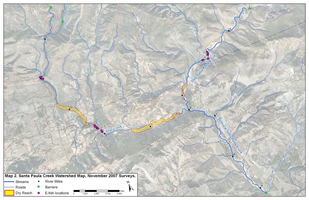
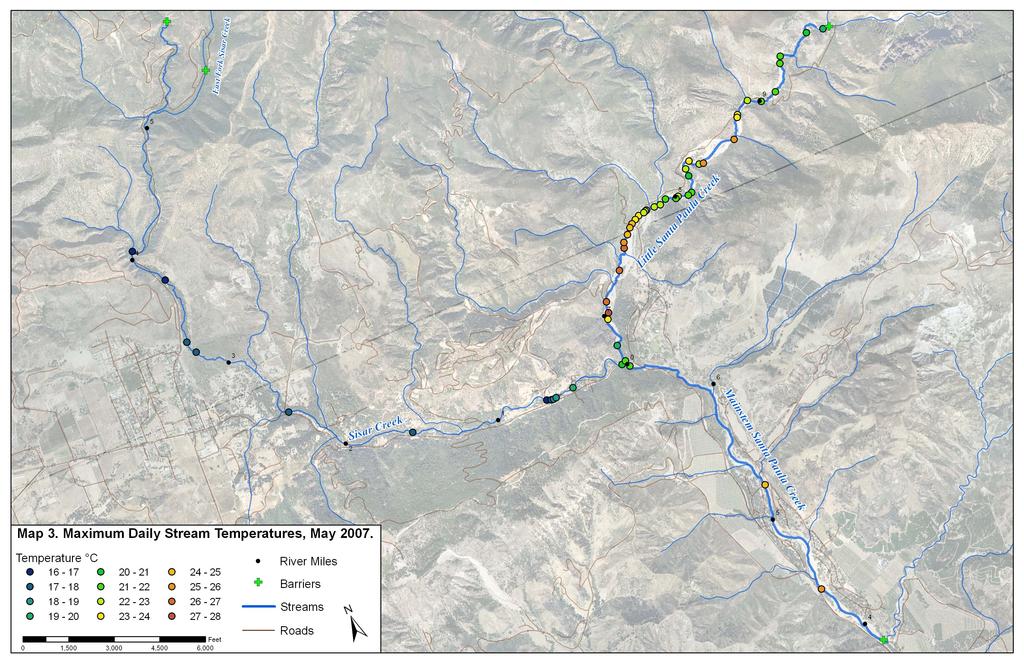
13 Steelhead Habitat and Population Assessment 3 RESULTS AND DISCUSSION 3.1 Stream Temperature Surveys The following sections provide results and discussion for stream temperature surveys conducted in May and November Dry Reaches In May 2007, all tributaries to the Little Santa Paula Creek reach were completely dry, with the exception of Sisar Creek. An additional dry reach of 0.06 miles was identified within Little Santa Paula Creek (near RM 7.1) and two dry reaches were identified within Sisar Creek (RM 0.6 to RM 1.4 and RM 2.5 to RM 3.2). Dry reaches observed in May 2007 are shown in Map 1. By the end of summer, the length of the dry reaches in Little Santa Paula and Sisar creeks increased significantly (Map 2). In Little Santa Paula Creek, the extent of the dry reach increased from a 0.06 miles in May to 0.3 miles in November, extending from RM 7.0 to RM 7.3. In Sisar Creek, the two dry reaches increased in length by 0.6 miles combined, with one reach extending from RM 0.2 to RM 1.4, and the other reach extending from RM 2.4 to RM 3.3. Cumulatively, the dry reaches in Sisar Creek reduced the available summer rearing habitat by 2.1 miles, which is equivalent to 32% of the stream length potentially accessible to anadromous O. mykiss in Sisar Creek. Recent surveys during the beginning of a wet water year, in November 2004, reported no dry reaches in either Little Santa Paula Creek or Sisar Creek (Stoecker and Kelley 2005). Although these surveys were not continuous in each creek, some of their sites were within reaches that were dry during our November 2007 surveys, indicating the extent of available habitat for O. mykiss may vary considerably from year to year May Maximum Daily Stream Temperatures Maximum daily stream temperatures in May ranged from 16 to 28 C within the study reaches. Little Santa Paula Creek had the highest maximum daily stream temperatures and the highest variability in daily temperature. Maximum daily stream temperatures in Little Santa Paula Creek ranged from 19 to 28 C. Measurements in Little Santa Paula Creek demonstrate a repeating pattern of cooling and warming of surface temperatures (Map 3). This pattern appears to correspond with variation in valley-bottom width (defined as the distance between valley walls perpendicular to the stream channel) and surface flow volume. As the valley-bottom widens, surface flow diminishes and maximum daily stream temperatures increase rapidly due to a combination of diminishing flow and direct insolation to the entire wetted channel (riparian shading is currently negligible). In areas where the valley-bottom width narrows, surface flow increases and temperatures cool abruptly, presumably due to increasing groundwater contributions to surface flow. The relationship of valley-bottom width (measured from using 2005 color orthophotos and 1 meter LIDAR DEM in GIS) and maximum daily stream temperature is illustrated in Figure
14 DRAFT Steelhead Habitat and Population Assessment Maximum Daily Stream Temperature ( C) Valley-bottom width (m) Figure 3-1. Relationship of valley-bottom width and maximum daily stream temperature in Little Santa Paula Creek, May Sisar Creek maintained cooler and less variable stream temperatures than Little Santa Paula Creek, likely due to the extensive riparian cover throughout Sisar Creek. Maximum daily stream temperatures in May were below 18.0 C (Map 3) with the exception of the lower 0.6 miles of Sisar Creek, in which temperatures reached 21 C. Within this portion of Sisar Creek stream temperature increased from 16.0 C to 19.0 C within 330 ft, likely due to a near total absence of riparian shading. Variation in valley-bottom width was less significant in Sisar Creek than in Little Santa Paula Creek, and although groundwater recharge was observed, it was less obvious from field observations how the geology and geomorphology of Sisar Creek contribute to patterns of surface flow. Dry reaches tended to be found in areas where water diversions or in-channel pumping occurred, suggesting that human water use contributes to stream drying in Sisar Creek. Mainstem Santa Paula Creek had consistently high maximum daily stream temperatures ranging from 21.6 C to 26 C (Map 3), although fewer stream measurements were taken in this reach due to the small number of O. mykiss observed (see O. mykiss presence and absence surveys below) Continuous Temperature Monitoring Temperature was monitored continuously from May through November. Stream temperatures reached maximum weekly average temperatures (MWAT) in early September. The greatest variability in MWAT occurred in Little Santa Paula Creek, ranging from 21.4 C to 25.8 C. Sisar Creek had lower and more consistent MWAT values than Little Santa Paula Creek, ranging from 20.4 C to 21.8 C (Figure 3-2). Longitudinal patterns in MWAT were similar to the repeated cooling and warming observed in maximum daily temperature in May (Figure 3-2; Map 3). Two thermographs were deployed in mainstem Santa Paula Creek but only one was retreived in November The only retrieved thermograph was immediately below the confluence and 10
15 Steelhead Habitat and Population Assessment was not representative of the reach, therefore preventing comparisons of MWAT to other creeks. The retreived thermograph was located just downstream of the confluence with Little Santa Paula Creek and resulted in an MWAT of 22.0 C, a value in-between the most downstream sites in both creeks above the confluence. Although the most downstream thermograph was not retrieved, we can infer by the close relationship of MWAT to maximum daily measurements in May, that stream temperatures warm with distance downstream from the confluence of Sisar Creek and Santa Paula Creeks. a) 26 Little Santa Paula Creek Temperature ( C) Confluence with Sisar Creek River Mile b) 26 Sisar Creek Temperature ( C) Confluence with Little Santa Paula Creek River Mile Figure 3-2. Maximum Weekly Average Temperature (MWAT) in a) Little Santa Paula Creek and b) Sisar Creek. All MWATS occurred during weeks ending in early September (9/4, 9/5, or 9/6),
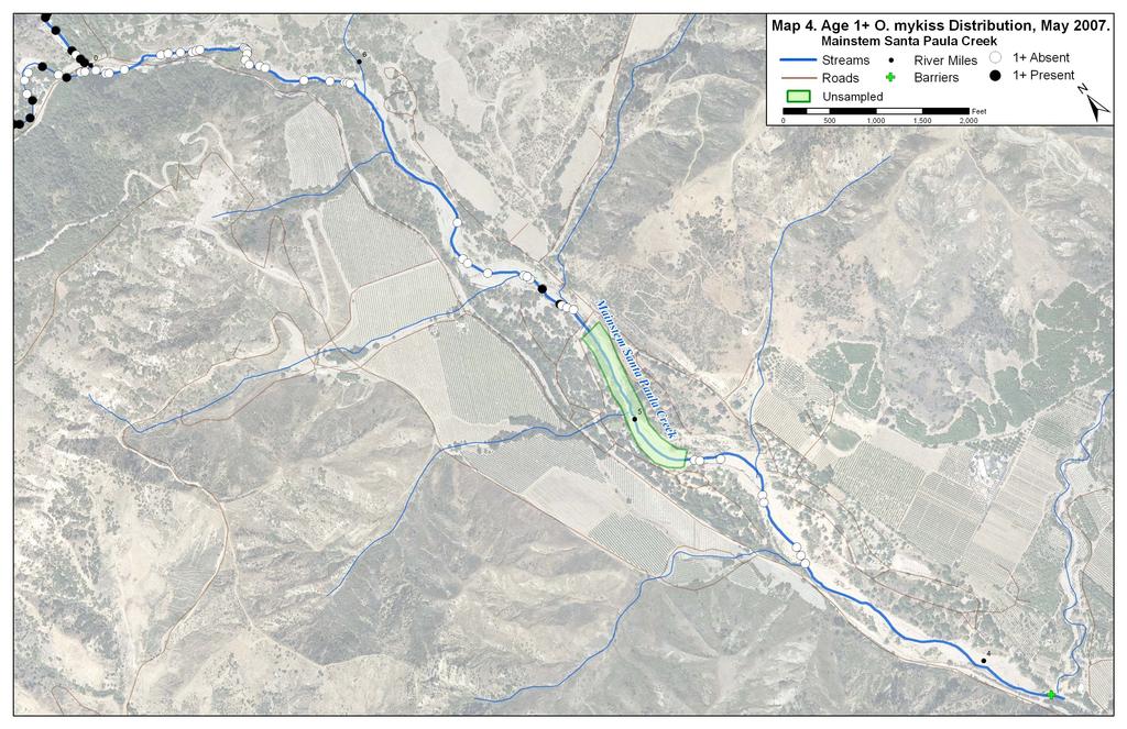
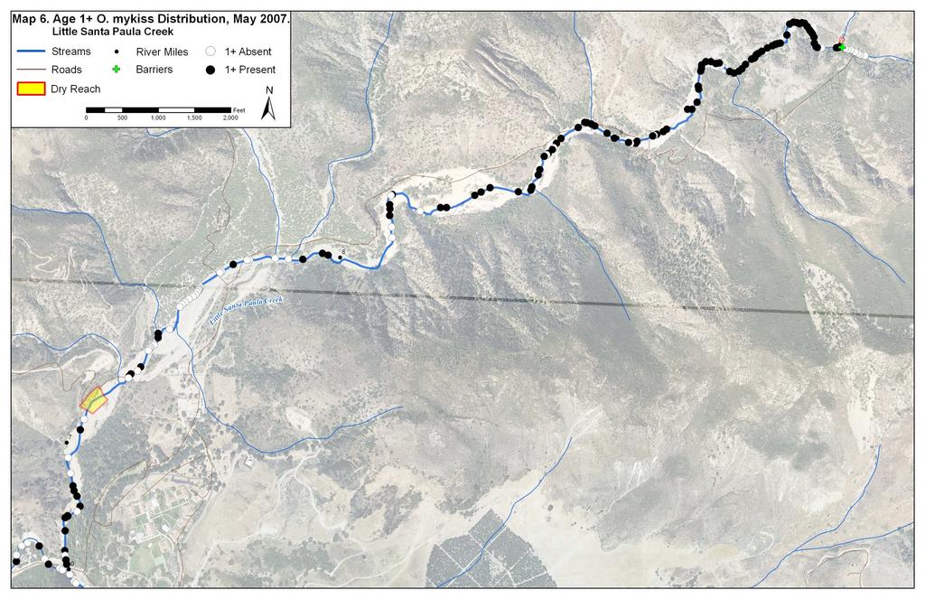
16 DRAFT Steelhead Habitat and Population Assessment Instantaneous data during the warmest week of the year indicated that sites with the highest stream temperatures also had the greatest daily fluctuation. Figure 3-3 show a daily fluctuation in stream temperature from representative hot, warm, and cool sites in Little Santa Paula Creek and a representative site in Sisar Creek. Instantaneous measurements indicate that at sites where MWAT remains below reported lethal limits for O. mykiss, instantaneous stream temperatures may exceed these limits for a significant portion of the day. Sites 6 (RM 7.4) and 7 (RM 7.6) exceeded critical thermal maximum temperatures in early September (Figure 3-3), defined as 29.6 C for the Central Valley steelhead (Myrick and Cech 2001) SPC 8; RM 8.0 SPC 7; RM 7.6 SPC 6; RM 7.4 Sisar 18; RM Temperature ( C) :00 2:00 4:00 6:00 8:00 10:00 12:00 14:00 16:00 18:00 20:00 22:00 0:00 2:00 4:00 September 2-3, :00 8:00 10:00 12:00 14:00 16:00 18:00 20:00 22:00 0:00 Figure 3-3. Continuous stream temperature in 15-minute intervals at four locations within the Santa Paula Creek watershed, September 4-5, O. mykiss Presence and Absence Surveys Potential summer rearing habitat for anadromous fish is primarily limited to Little Santa Paula Creek extending upstream 3.2 miles from the confluence with Sisar Creek to waterfall barriers, and all portions of Sisar Creek below the barriers at RM 5.9 All other tributaries to Santa Paula Creek were completely dry by May. A total of 278 pools were surveyed for O. mykiss within the Santa Paula Creek watershed. The rates of observation for age 1+ O. mykiss in May were highest in Sisar Creek (75 out of 86 pools), lower in Little Santa Paula Creek (102 out of 148 pools), and extremely low in mainstem Santa Paula Creek, where only two age 1+ O. mykiss were observed (2 out of 44 pools). A summary of pools with observed age 1+ O. mykiss is provided in Table
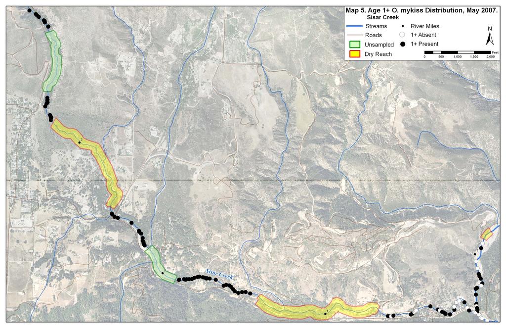
17 Steelhead Habitat and Population Assessment Table 3-1. Age 1+ O. mykiss presence in pools within the Santa Paula Creek watershed, May Reach # of Pools with Age 1+ Total Pools Surveyed % of Total Pools with Age 1+ Little Santa Paula % Sisar Creek % Mainstem Santa Paula 2 44 <1% Totals % The mainstem Santa Paula Creek, downstream of the confluence with Sisar Creek, supported age 1+ O. mykiss in only 2 out of the 44 pools surveyed in this reach (Table 3-1; Map 4), but also provided habitat for other species such as Santa Ana Sucker, Arroyo Chub, and threespine stickleback. This is consistent with observations made by Stoecker and Kelley (2005), where stream bank and direct observation surveys below the confluence of Sisar Creek and Little Santa Paula Creek resulted in zero observations of O. mykiss and the most consistent observations of non-salmonid species. This reach had the lowest pool frequency and exhibited warmer temperatures in comparison to locations throughout Little Santa Paula Creek and Sisar Creek. In addition to these habitat characteristics, natural oil and tar seeps, as well as milky sulfur seeps contribute to poor habitat quality for O. mykiss in the mainstem Santa Paula Creek. Of the three main reaches surveyed, Sisar Creek contained the highest percentage of pools containing age 1+ O. mykiss (87%; Table 3-1, Map 5). In wetted reaches between RM 0.6 and RM 4.1, almost every pool surveyed contained age 1+ O. mykiss. Riparian cover was more consistent in this section of Sisar Creek, resulting in cooler stream temperatures that provided habitat for a higher frequency of age 1+ O. mykiss than the first 0.6 mile of Sisar Creek. Our May 2007 surveys did not extend upstream of RM 4.1 to the two barriers identified by Stoecker and Kelley in 2005 (Sisar Creek at RM 5.9 and East Fork Sisar Creek RM 0.5). Within this reach, Stoecker and Kelley (2005) observed the highest densities of O. mykiss over 6, indicating good habitat quality and suggesting O. mykiss presence would likely extend to the two barriers. Our May 2007 field work did not repeat Soecker and Kelley s (2005) survey of this upper reach because our objective was to survey areas that had not already been surveyed. Fewer observations of age 1+ O. mykiss within the first 0.6 miles of Sisar Creek may be a result of lower surface flow and decreased riparian shading. Although this reach exhibited the warmest temperatures in Sisar Creek, temperatures did not exceed 21.0 C (a temperature at which O. mykiss were commonly observed in Little Santa Paula Creek) indicating other factors may be acting in concert with stream temperature to influence habitat quality for age 1+ O. mykiss within this reach (Map 3, Map 5). In Little Santa Paula Creek, age 1+ O. mykiss were observed throughout the reach for the exception of one portion, between the confluence with Sisar Creek (RM 6.6; Map 6) and La Broche Creek (RM 7.9). The relatively low rate of occurrence in this section of Little Santa Paula Creek could be related to high stream temperatures in that reach. At the time of the May survey, maximum daily stream temperatures were already at 27.8 C, approaching previously reported lethal limits for O. mykiss (29.6 C; Myrick and Cech 2001). Even though there was a low rate of occurrence in this reach, O. mykiss were present, indicating these temperatures did not exceed lethal values during May. 13
18 DRAFT Steelhead Habitat and Population Assessment During our November 2007 survey, O. mykiss were not present in the warmest location where relatively low rate of occurrence was observed in May, near thermograph Site 6 (RM 7.4; Map 7). This location consistently exceeded 30.0 C for three months, from July through August, with maximum temperatures over 33 C during the hottest day of the year (Figure 3-3; Map 7). However, O. mykiss were observed just upstream near thermograph Site 7 (RM 7.6), where temperatures exceeded 30 C for a much shorter duration (only 6 days out of the summer), but reached 31.4 C during the hottest day of the year (Figure 3-3; Map 7). These temperatures and the presence of O. mykiss are not consistent with laboratory experiments where 29.6 C is defined as the critical thermal maximum temperature for steelhead (Myrick and Cech 2001), and indicates southern steelhead may have higher critical thermal maximum temperature than northern populations. An exception to these patterns of temperature and O. mykiss presence was the observation of one age 1+ O. mykiss that was observed in an isolated pool in the middle of the dry reach (RM 7.1; Map 7). Although data on small seeps was not gathered, some observations of local pockets of cool water in warm pools was observed during the previous survey, and may explain the rare presence of age 1+ O. mykiss within the dry reach. Stream temperature data is not available within the proximity of this isolated pool, making it difficult to come to conclusions on thermal tolerances at this location. 3.3 O. mykiss Population Surveys The following sections provide results and discussion for O. mykiss habitat and population surveys conducted in May and November Habitat measurements Reach-level habitat measurements identified pool and pocketwater habitat as the most common habitat types in both Little Santa Paula Creek and Sisar Creek and were therefore chosen as the two habitat types to compare O. mykiss densities for the November 2007 population surveys. Riffles occurred infrequently, and quick single-pass electrofishing in these habitats confirmed they provided little or no habitat for O. mykiss within our surveyed reaches. Run habitat was present at only one site, and comprised a small percentage of the stream channel when it was present. Table 3-2 summarizes the area of each habitat type within each reach. Table 3-2. Habitat type areas (m² and percent of total) in reaches of Little Santa Paula Creek (SPC) and Sisar Creek (Lower Sisar Creek [LSC] and Upper Sisar Creek [USC]), November Creek Reach Pool Area Pocketwater Area Riffle Area Run Area Total Area Little Santa Paula Creek Sisar Creek m² % m² % m² % m² % m² SPC , ,788 LSC USC Detailed habitat measurements were taken at each habitat unit that was electrofished. Maximum depths in the units sampled in Little Santa Paula Creek ranged from 2.1 to 2.8 ft (0.64 to 0.85 m) deep for pools and from 1.0 to 1.8 ft (0.30 to 0.55 m) deep for pocketwater habitat. Maximum 14
19 Steelhead Habitat and Population Assessment pool depth in units sampled in Sisar Creek ranged from 2.0 to 2.5 ft (0.61 to 0.76 m) at the lower sample reach and 2.7 to 3.2 ft (0.82 to 0.98 m) at the upper sample reach. Pocketwater depth in Sisar Creek was consistent at all sites, ranging from 1.2 to 1.4 ft (0.36 to 0.43 m) deep. The amount of available cover varied little between reaches and primarily consisted of unembedded cobble/boulder complexes and some aquatic vegetation at most sampled units. One exception was a unit in Little Santa Paula Creek, that was a bedrock dominated pool with little cobble/boulder substrate for cover. This unit also resulted in the lowest O. mykiss densities out of all the sites, indicating cobble/boulder substrate may provide the majority of usable cover within the Santa Paula Creek watershed. Sample site selection was not random. We chose relatively good habitat in both Little Santa Paula Creek and Sisar Creek and these habitat measurements are not necessarily representative of habitat in other reaches potentially supporting O. mykiss. Extrapolations of our densities could lead to an overestimate of the O. mykiss population in Santa Paula Creek. A more comprehensive habitat and population survey including representative reaches would be necessary to determine the O. mykiss population throughout the watershed O. mykiss Density Surveys A total of 18 units (nine pools and nine pocketwaters) were surveyed for O. mykiss densities within Little Santa Paula Creek and Sisar Creek. Densities were similar in Little Santa Paula Creek (ranging from 0.10 fish/m² to 0.96 fish/m²) and in Sisar Creek (ranging from 0.31 fish/m² to 0.87 fish/m²). Densities were also similar between habitat types, although pool habitats resulted with the highest densities of O. mykiss in both creeks. Since age classes were difficult to distinguish (see O. mykiss Age Class Structure), O. mykiss densities were inclusive of all age classes. Figure 3-4 shows densities for both habitat types in each reach. 15
20 DRAFT Steelhead Habitat and Population Assessment Fish density (fish/m 2 ) (4) POW (4) Pool (5) POW (5) Pool Little Santa Paula Creek Reach Sisar Sisar Creek Figure 3-4. Boxplots for O. mykiss densities in pocket water (POW) and pool habitat types between Little Santa Paula Creek and Sisar Creek. Center line of the box is the median; upper and lower edges are upper quartile and lower quartile respectively. The range is represented by horizontal bars above and below the boxes. Sample sizes are in parentheses above the boxplots. Pool habitat in Little Santa Paula Creek exhibited the largest range of O. mykiss densities, ranging from 0.10 fish/m² to 0.96 fish/m². The pool with the lowest density was in the only unit that was a bedrock controlled pool and provided little cobble/boulder complexes for cover. Pocketwater habitat ranged from 0.13 fish/m² to 0.60 fish/m² and resulted in slightly lower O. mykiss densities than pool habitat, but field observations during electrofishing surveys noted sections of pocketwater that provided a combination of depth and cobble/boulder cover often provided habitat for O. mykiss. This suggests that O. mykiss use both pool and pocketwater habitat as long as cobble/boulder cover and depth are available. More detailed habitat measurements within each unit would be required to determine if there is a minimum depth requirement for O. mykiss in this reach. Sisar Creek had similar ranges for O. mykiss densities in both pool and pocketwater habitat, ranging from 0.47 fish/m² to 0.87 fish/m² and 0.31 fish/m² to 0.84 fish/m², respectively. When compared to Little Santa Paula Creek, O. mykiss densities in Sisar Creek are similar, indicating both creeks provide important habitat for juvenile rearing. O. mykiss densities observed in pool habitat in the Santa Paula Creek watershed resulted in higher densities than most tributaries in Sespe Creek, the neighboring watershed east of Santa Paula Creek (Dvorsky 2000). Although snorkel surveys were used in Sespe Creek, we have used them as a comparison to densities in Santa Paula Creek because previous studies within the region show results from electofishing and snorkel surveys are similar (Chubb, USFS, unpublished data, as cited in Dvorsky 2000). The relatively high densities in Santa Paula creek are consistent with 16
21 Steelhead Habitat and Population Assessment previous reports that suggest Santa Paula Creek has high habitat quality relative to other Santa Clara River tributaries, and has been identified as one of the greatest potential creeks for recovery of the Southern California O. mykiss DPS (Stoecker and Kelley 2005) O. mykiss Age Class Structure A total of 440 O. mykiss were captured during the electrofishing surveys. Throughout the watershed, fork lengths ranged from mm, with over 90% of all captured O. mykiss measuring between mm. Length frequency histograms can usually be used to determine length at age for O. mykiss populations, however differentiating length at age for populations in Santa Paula Creek watershed is difficult. Up to four age classes are potentially identifiable from the length frequency data. In Little Santa Paula Creek, over 62% of the O. mykiss measured ranged from mm (FL) and most likely were comprised of a combination of age 0+ and age 1+fish (Figure 3-5). Similar to Little Santa Paula Creek, a majority of O. mykiss were in a similar range of mm and also display a possible overlap of age 0+ and age 1+ fish. The exact size range of each age class is difficult to determine because of the lack of obvious modes in length frequencies. In more northern populations such as Devil s Gulch, a tributary to Lagunitas Creek (Marin County, California), length at age is better identifiable because seasonality separates growing seasons and results in a clearer separation in modes for each age class (Figure 3-5). The difficulty in distinguishing between the age 0+ and age 1+ fish length frequency graphs could indicate that sublethal effects of temperature have influenced the growth potential for O. mykiss. The length frequencies indicate age 0+ O. mykiss are large at the end of their first summer suggesting good growth opportunities, however, age 1+ fish are relatively small. Previous studies in the Napa River (Napa County, California) have found that smaller fish are able to achieve positive growth under warm conditions whereas the larger age 1+ fish have difficulty achieving bioenergetic demands in warm reaches. Without scale analyses, it is impossible to reach conclusions about age class structure and to determine whether the growth of age 1+ O. mykiss is reduced due to bioenergetic limitations in Santa Paula Creek. Another pattern apparent of the length frequency is the observation of few O. mykiss over 145 mm in both creeks. From Figure 3-5, fish above 145 mm could be potentially separated into two additional age classes, with an age 2+ class ranging from mm (FL) and an age 3+ class with lengths above 210 mm (FL). There are two possible explanations for the few observations of O. mykiss in these age classes. The first possibility is that food availability was not sufficient for larger fish (e.g., >145 mm) to meet the metabolic demands required to forage in the relatively warm reaches, and resulted in reduced survival. The second possibility is the high flows in January and February 2005 (maximum flood of record) resulted in redd scour and displacement of fry in 2005, which would have represented the age 2+ and older age classes we observed few of during our 2007 surveys. Conclusions regarding these hypotheses cannot be reached without aging from scale samples to determine growth and age class structure. Scale samples were taken from each unit during the electrofishing surveys, but the limitations of the scope of this project did not include analyses of these samples. Future studies could potentially analyze these scale samples, resulting in determination of age class specific densities and to determine difference in growth rates for each age class. 17
22 DRAFT Steelhead Habitat and Population Assessment a) 25 Santa Paula Creek b) 25 Lower Sisar Creek n= n= Fork Length (mm) 25 Upper Sisar Creek n= Number of Fish Number of Fish d) 250 Age 0+ Devil's Gulch Number of Fish Number of Fish Fork Length (mm) c) Age Fork Length (mm) Length (mm) Figure 3-5. Comparison of length frequency histograms for O. mykiss in a) Little Santa Paula Creek, b) Lower Sisar Creek, and c) Upper Sisar Creek in November 2007, and d) Devil s Gulch (Lagunitas Creek, Marin Co.) in October 2006 (Stillwater Sciences, in progress). 18
23 Steelhead Habitat and Population Assessment 4 CONCLUSIONS Potential summer rearing habitat for restored anadromous populations of O. mykiss is limited to the extent of Little Santa Paula Creek from the confluence with Sisar Creek upstream to the natural waterfall barrier at the confluence of Little Santa Paula Creek and East Fork Santa Paula Creek (RM 9.8), and in Sisar Creek from its mouth upstream to barriers on Sisar Creek (RM 5.9) and East Fork Sisar Creek (RM 0.5). These creeks provided consistent observations of age 1+ O. mykiss during our May survey, and similar densities during our November survey. This indicates both creeks provide important juvenile rearing habitat for these species and passage restoration efforts should focus on access allowing migration to upstream of their confluence. The densities observed were high compared to neighboring streams and supports previous reports suggesting Santa Paula Creek as having some of the highest potential for restoration of anadromous O. mykiss within the Santa Clara watershed. In the few locations where O. mykiss were not observed in these reaches, it was a result of either a dry channel or relatively warm stream temperatures, indicating dry reaches and temperature are the primary environmental controls on juvenile rearing habitat quality. The mainstem Santa Paula Creek appeared to provide poor habitat for O. mykiss based on the few observations of age 1+ fish during our May survey. Although temperatures were relatively warm in this reach, qualitative observations of poor visibility and water quality also likely contribute to the lack of O. mykiss. Natural oil and tar seeps, as well as milky sulfur seeps throughout the mainstem Santa Paula Creek contribute to poor habitat quality for O. mykiss. Spatial patterns of stream temperature are markedly different between Sisar Creek and Little Santa Paula Creek. In Sisar Creek, extensive riparian shading maintains relatively cool stream temperatures in the majority of the wetted reaches despite the stream losing surface flow in two locations. The effects of riparian shading are evident in the lower portion of Sisar Creek which in May heated from approximately 16.0 C to 19.0 C in just 330 ft in a reach that completely lacked riparian vegetation. In comparison to Sisar Creek, Little Santa Paula Creek had much greater variability in stream temperature. In contrast to a more typical pattern in which stream temperature gradually increases as a stream flows to lower elevations, temperature in Little Santa Paula Creek exhibits a repeated pattern of cooling and warming. This pattern is predictable, with warmer temperatures occurring in reaches with wider valley-bottom widths and diminishing surface flow, and cooler temperatures occurring in reaches with narrower valley-bottom widths where cool hyporheic flow resurfaces. Because Little Santa Paula Creek currently has virtually no riparian vegetation, water temperature heats rapidly in wider valley segments, approaching 33 C maximum daily temperature in some areas. The consequence of these temperature dynamics is that O. mykiss may be restricted from some reaches due to high stream temperatures. In Little Santa Paula Creek, we found O. mykiss in habitat with stream temperatures exceeding 29.6 C, the reported lethal limit for the Central Valley steelhead (Myrick and Cech 2001). Central Valley steelhead temperature thresholds were used for comparison because we are not aware of published temperature thresholds for southern steelhead, and the presence of O. mykiss in temperatures exceeding this published value provides evidence for higher thermal tolerances in southern populations. However, despite potential adaptation for warmer conditions, we also found that fish did not persist over the summer in the warmest reach of Little Santa Paula Creek. The results of a comparison of fish presence in May and November suggests that fish were found in pools where maximum daily stream temperature 19
24 DRAFT Steelhead Habitat and Population Assessment approached 31.5 C, but were absent in pools exceeding in 33 C, suggesting upper thermal limits for O. mykiss in Santa Paula Creek may be within this range. In addition to acute effects of temperature on fish persistence, there may be sublethal effects of high stream temperature on fish growth. Length frequency histograms may provide some evidence for sublethal effects of high stream temperatures. Although we were not able to conclusively differentiate between age 0+ and age 1+ fish from their length frequencies, the unimodal pattern in November suggests that growth of age 0+ fish was good but opportunities for age 1+ and older fish may be limited. Together, these results provide important information on habitat conditions and fish abundance in the Santa Paula Creek watershed that can be readily incorporated into an expanded study of factors limiting the O. mykiss populations. In and of themselves, the results suggest that, to the extent possible, maintenance of riparian vegetation and protection of groundwater resources would be important components of a management plan for O. mykiss in the watershed. The results also suggest several future studies that could reduce uncertainty about factors limiting the O. mykiss populations. First, we recommend that scale samples be analyzed to confirm the length-at-age for fish. This information would help test hypotheses regarding growth potential and bioenergetic limitations for fish. If high warm temperatures are preventing large fish from reaching suitable sizes for successful smolting, then bioenergetic studies including analyses of macroinvertebrate food availability could help identify reasons for limited growth. The information could also be used to develop age-class specific density information from the data already collected and could be an important tool for identifying potential recruitment bottlenecks for fish populations. Second, continuous stream temperature monitoring could be paired with additional studies to document the persistence of O. mykiss using pit tags. Individually marked fish in different thermal environments would provide more detailed empirical evidence for stream temperature thresholds for southern populations of O. mykiss. 20
25 Steelhead Habitat and Population Assessment 5 REFERENCES Boughton, D. A., P. B. Adams, E. Anderson, C. Fusaro, E. Keller, E. Kelley, L. Lentsch, J. Nielsen, K. Perry, H. Regan, J. Smith, C. Swift, L. Thompson, and F. Watson Steelhead of the southcentral/southern California coast: population characterization for recovery planning. Technical Memorandum NMFS-SWFSC-394. National Marine Fisheries Service, Southwest Fisheries Science Center, Santa Cruz, California. TM-NMFS-SWFSC-394.pdf. Dvorsky, J.R The influence of valley morphology and coarse sediment distribution on rainbow trout populations in Sespe Creek, California at the landscape scale. Master's thesis. University of California, Santa Barbara. Flosi, G., S. Downie, J. Hopelain, M. Bird, R. Coey, and B. Collins California Salmonid Stream Habitat Restoration Manual. California Department of Fish and Game, Sacramento, CA. Mohr, M. S., and D. G. Hankin Two-phase survey designs for estimation of fish abundance in small streams. NOAA Technical Memorandum NMFS-SWFSC. Myrick, C. A., and Jr. J. J. Cech Temperature effects on chinook salmon and steelhead: a review focusing on California's Central Valley populations. Prepared by Department of Fishery and Wildlife Biology, Colorado State University, Fort Collins and Department of Wildlife, Fish, and Conservation Biology, University of California, Davis for the Bay-Delta Modeling Forum. Pollock, K. H. and M. C, Otto Robust estimation of population size in closed animal populations from capture-recapture experiments. Biometrics 39: Stillwater Sciences. In progress. Lagunitas limiting factors analysis: limiting factors for coho salmon and steelhead. Prepared for Marin Resource Conservation District. Draft. Stoecker, M. and E. Kelley Santa Clara River steelhead trout: assessment and recovery opportunities. Prepared for The Nature Conservancy and The Santa Clara River Trustee Council. pp
26
27 Steelhead Habitat and Population Assessment MAPS
28
29
30
31
32
33
34
Executive Summary. Map 1. The Santa Clara River watershed with topography.
 Santa Clara River Steelhead Trout: Assessment and Recovery Opportunities December 2005 Prepared By: Matt Stoecker and Elise Kelley, Ph.D. University of California, Santa Barbara Prepared For: The Santa
Abundance of Steelhead and Coho Salmon in the Lagunitas Creek Drainage, Marin County, California
 scanned for KRIS Abundance of Steelhead and Coho Salmon in the Lagunitas Creek Drainage, Marin County, California Prepared for: Marin Municipal Water District 220 Nellen Drive Corte Madera, California
Study Update Tailrace Slough Use by Anadromous Salmonids
 Study Update Tailrace Slough Use by Anadromous Salmonids Goals and Objectives Identify what anadromous salmonids use the tailrace slough by: Life Stage (Juvenile, migrating and spawning adults) Timing
STEELHEAD SURVEYS IN OMAK CREEK
 STEELHEAD SURVEYS IN OMAK CREEK 2002 Annual Report Prepared by Chris Fisher John Arterburn Colville Confederated Tribes Fish and Wildlife Department P.O. Box 150 Nespelem, WA 99155 Prepared for Project
Study Update Fish Distribution and Species Composition
 Study Update Fish Distribution and Species Composition Goals and Study Area Gain a better understanding of fish species composition and abundance in waters associated with the Packwood Lake Hydroelectric
Final Bull Trout Genetics Monitoring Plan for the Wallowa Falls Hydroelectric Project. (FERC No. P-308) June 2017
 June 2017") Final for the Wallowa Falls Hydroelectric Project (FERC No. P-308) June 2017 Prepared by: Jeremiah Doyle PacifiCorp 825 NE Multnomah Street Portland, OR 97232 June, 2017 Page 1 of 8 Table of Contents 1.0
Final for the Wallowa Falls Hydroelectric Project (FERC No. P-308) June 2017 Prepared by: Jeremiah Doyle PacifiCorp 825 NE Multnomah Street Portland, OR 97232 June, 2017 Page 1 of 8 Table of Contents 1.0
State of San Francisco Bay 2011 Appendix O Steelhead Trout Production as an Indicator of Watershed Health
 State of San Francisco Bay 2011 Appendix O Steelhead Trout Production as an Indicator of Watershed Health Gordon Becker and Katherine Smetak, Center for Ecosystem Management and Restoration 290 Introduction
Data Report : Russian River Basin Steelhead and Coho Salmon Monitoring Program Pilot Study
 Data Report 1999-1: Russian River Basin Steelhead and Coho Salmon Monitoring Program Pilot Study Sonoma County Water Agency 215 West College Avenue Santa Rosa, California 951 Prepared by David Cook Senior
Chinook Salmon Spawning Study Russian River Fall 2005
 Chinook Salmon Spawning Study Russian River Fall 2005 Sonoma County Water Agency 2150 West College Avenue Santa Rosa, California 95401 Prepared by David Cook - Senior Environmental Specialist March 27,
Southern Oregon Coastal Cutthroat Trout
 Species Management Unit Description Southern Oregon Coastal Cutthroat Trout The Southern Oregon Coastal Cutthroat Trout SMU includes all populations of cutthroat trout inhabiting ocean tributary streams
Final Bull Trout Redd Monitoring Report for the Wallowa Falls Hydroelectric Project
 Final for the Wallowa Falls Hydroelectric Project East Fork Wallowa River barrier to upstream fish migration, photo courtesy of Kendrick Moholt (FERC No. P-308) December 18, 2017 Prepared by: Jeremiah
Redd Dewatering and Juvenile Salmonid Stranding in the Lower Feather River,
 Redd Dewatering and Juvenile Salmonid Stranding in the Lower Feather River, 2005-2006 Interim Report for NOAA Fisheries Prepared by: California Department of Water Resources Division of Environmental Services
Job 1. Title: Estimate abundance of juvenile trout and salmon.
 STUDY PERFORMANCE REPORT State: Michigan Project No.: F-53-R-13 Study No.: 461 Title: Population dynamics of juvenile rainbow trout and coho salmon in Lake Superior tributaries Period Covered: April 1,
FISHERIES BLUE MOUNTAINS ADAPTATION PARTNERSHIP
 FISHERIES A warming climate, by itself, substantially affects the hydrology of watersheds in the Blue Mountains. Among the key hydrologic changes projected under all scenarios for the 2040s and beyond
Five Counties Salmonid Conservation Program - Fish Passage Design Workshop. February 2013
 Program - Aquatic Organisms and Stream Crossings Ecological Connectivity A watershed is a network of channels that drain a common boundary. Channel characteristics formed by interaction of precipitation,
Oregon Coast Coastal Cutthroat Trout
 Oregon Coast Coastal Cutthroat Trout Species Management Unit Description The Oregon Coast Coastal Cutthroat Trout Species Management Unit (SMU) includes all populations of cutthroat trout inhabiting ocean
August 11 Snorkel SCC side channel network (SBA, SCC3) feet 707
 feet 707") Date Survey Type Habitat July 29 Snorkel (reconnaissance) Table 1. Fish use survey schedule 2004 Water temperature 1 (ºC) Estimated Mean visibility 2 discharge 3 (cfs) Mainstem (units #1 42) ND ND 814
Date Survey Type Habitat July 29 Snorkel (reconnaissance) Table 1. Fish use survey schedule 2004 Water temperature 1 (ºC) Estimated Mean visibility 2 discharge 3 (cfs) Mainstem (units #1 42) ND ND 814
2011 SUMMARY REPORT Juvenile Steelhead Densities in the San Lorenzo, Soquel, Aptos and Corralitos Watersheds, Santa Cruz County, CA
 211 SUMMARY REPORT Juvenile Steelhead Densities in the San Lorenzo, Soquel, Aptos and Corralitos Watersheds, Santa Cruz County, CA, Aquatic Biology Don Alley, Jerry Smith and Chad Steiner, Fishery Biologists
San Lorenzo Valley Water District, Watershed Management Plan, Final Version Part I: Existing Conditions Report
 LIST OF FIGURES Figure 1-1. Map of the San Lorenzo River watershed Figure 2-1. The Santa Cruz Mountains Bioregion Figure 2-2. Protected areas within the San Lorenzo River watershed Figure 2-3. Primary
The Effects of Stream Adjacent Logging on Downstream Populations of Coastal Cutthroat Trout
 The Effects of Stream Adjacent Logging on Downstream Populations of Coastal Cutthroat Trout. D. S. Bateman 1, R.E. Gresswell 2, Aaron M. Berger 3, D.P. Hockman-Wert 4 and D.W. Leer 1 1 Department of Forest
1998 Willow Creek Downstream Migrant Trap Report. Draft. Prepared By: C. A. Walker. Lower Trinity Ranger District. Six Rivers National Forest
 1998 Willow Creek Downstream Migrant Trap Report Draft Prepared By: C. A. Walker Lower Trinity Ranger District Six Rivers National Forest September 1998 Executive Summary The downstream migrant trap was
THE OREGON PLAN for. Salmon and Watersheds. Smith River Steelhead and Coho Monitoring Verification Study, Report Number: OPSW-ODFW
 THE OREGON PLAN for Salmon and Watersheds Smith River Steelhead and Coho Monitoring Verification Study, 2007 Report Number: OPSW-ODFW-2009-11 The Oregon Department of Fish and Wildlife prohibits discrimination
OREGON DEPARTMENT OF FISH AND WILDLIFE ROGUE FISH DISTRICT REPORT
 OREGON DEPARTMENT OF FISH AND WILDLIFE ROGUE FISH DISTRICT REPORT TITLE: Upper Rogue Smolt Trapping Project, 1999 STREAM: Big Butte, Little Butte, South Fork Big Butte, Slate and West Fork Evans Creeks
Minnesota Department of Natural Resources Division of Fish and Wildlife Section of Fisheries. Stream Survey Report. Luxemburg Creek.
 Minnesota F-29-R(P)-24 Area 315 Study 3 March 2016 Minnesota Department of Natural Resources Division of Fish and Wildlife Section of Fisheries Stream Survey Report Luxemburg Creek 2015 Mark Pelham Sauk
Klamath Lake Bull Trout
 Klamath Lake Bull Trout Existing Populations The Klamath Lake Bull Trout SMU is comprised of seven existing populations and four populations classified as extinct or functionally extinct (Table 189). Populations
TABLE 1. Riverscape surveys completed in the upper Chehalis River, Newaukum, and Satsop rivers.
 RIVERSCAPE SURVEYS OF IN-STREAM FISH ASSEMBLAGES AND HABITAT IN THE CHEHALIS RIVER Mara Zimmerman and John Winkowski Washington Department of Fish and Wildlife, Fish Program EXECUTIVE SUMMARY Introduction
ELECTRO-FISHING REPORT 2016 UPPER TWEED
 ELECTRO-FISHING REPORT 2016 UPPER TWEED The electro-fishing programme carried out each summer by The Tweed Foundation is part of our management plan, which details the information that is required to manage
5B. Management of invasive species in the Cosumnes and Mokelumne River Basins
 5B. Management of invasive species in the Cosumnes and Mokelumne River Basins Cosumnes River The Cosumnes River basin has a number of distinct habitat types that require different management strategies
Alberta Conservation Association 2017/18 Project Summary Report
 Alberta Conservation Association 2017/18 Project Summary Report Project Name: Abundance, Distribution, Spawning, and Thermal Habitat of Westslope Cutthroat Trout and Bull Trout in the Stimson Creek Watershed
Trip Report: Eagle Creek, Arizona
 Trip Report: Eagle Creek, Arizona 15-17 June 2009 Participants: Abraham Karam, Brian Kesner, and Mike Childs Native Fish Lab Marsh & Associates, LLC 5016 South Ash Avenue Suite 108 Tempe, Arizona 85282
Ecology of Columbia River redband trout (Oncorhynchus mykiss gairdneri) in high desert streams
 in high desert streams") Ecology of Columbia River redband trout (Oncorhynchus mykiss gairdneri) in high desert streams Dry Creek October 2012 Chris A. Walser Ph.D., Professor of Biology Department of Biology and Environmental
Ecology of Columbia River redband trout (Oncorhynchus mykiss gairdneri) in high desert streams Dry Creek October 2012 Chris A. Walser Ph.D., Professor of Biology Department of Biology and Environmental
Appendix A Recommended EPA Temperature Thresholds for use in Establishing Thermal Potential and Species Life Stage Numeric Criteria
 Appendix A Recommended EPA Temperature Thresholds for use in Establishing Thermal Potential and Species Life Stage Numeric Criteria 1. Temperature Limits Recommended to Protect Salmonid Guilds In this
Interim Guidance Fish Presence Absence
 Interim Guidance Fish Presence Absence Source: Forest Practices Act Guidance for Division 635 of the forest practices act dealing with stream classification when no fish surveys have been done (referenced
Warner Lakes Redband Trout
 Warner Lakes Redband Trout Existing Populations Warner Valley is an endorheic basin that contains a complex series of interconnected lakes, marshes, sloughs, and potholes, all of which are remnants of
Juvenile Steelhead and Stream Habitat Conditions Steelhead and Coho Salmon Life History Prepared by: DW ALLEY & Associates, Fishery Consultant
 Juvenile Steelhead and Stream Habitat Conditions Steelhead and Coho Salmon Life History Prepared by: DW ALLEY & Associates, Fishery Consultant I-1. Steelhead and Coho Salmon Ecology Migration. Adult steelhead
Catlow Valley Redband Trout
 Catlow Valley Redband Trout Existing Populations The Catlow Valley Redband Trout SMU is comprised of five populations (Table 1). Three exist in Home, Threemile, and Skull creeks, located on the east side
Jason Blackburn, Paul Hvenegaard, Dave Jackson, Tyler Johns, Chad Judd, Scott Seward and Juanna Thompson
 Alberta Conservation Association (ACA) Date: 2014-2015 Project Name: Owl River Walleye and Aquatic Habitat Assessment Fisheries Program Manager: Peter Aku Project Leader: Tyler Johns Primary ACA staff
THE CONFEDERATED TRIBES OF THE WARM SPRINGS RESERVATION OF OREGON
 THE CONFEDERATED TRIBES OF THE WARM SPRINGS RESERVATION OF OREGON To: Branch of Natural Resources P.0. Box C, Warm Springs, Oregon 97761 Phone (541) 553-2002/2003 Fax (541) 553-1994 The Independent Science
Sub-watershed Summaries
 Project Description The Salmon Drift Creek Watershed Council (SDCWC) has focused their efforts in the Salmon River estuary for the past few years. The multifaceted partnership effort is nearing completion
2012 Summary Report on the Juvenile Salmonid and Stream Habitat Monitoring Program
 2012 Summary Report on the Juvenile Salmonid and Stream Habitat Monitoring Program Prepared by: Kristen Kittleson, Fishery Resource Planner County of Santa Cruz Water Resources Program January 10, 2012
2 nd Steelhead Summit. October 27 & 28, 2016 in San Luis Obispo, CA
 + 2 nd Steelhead Summit October 27 & 28, 2016 in San Luis Obispo, CA 1 + Session Overview Sponsors: California Trout City of San Luis Obispo Sustainable Conservation California Conservation Corps Cachuma
3. The qualification raised by the ISRP is addressed in #2 above and in the work area submittal and review by the ISRP as addressed in #1.
 Please find attached a response from The Confederated Tribes of the Warm Springs Reservation of Oregon (CTWSRO) for Project # 2008-301-00, Habitat Restoration Planning, Design and Implementation within
EXHIBIT ARWA-700 TESTIMONY OF PAUL BRATOVICH
 EXHIBIT ARWA-700 TESTIMONY OF PAUL BRATOVICH 1. I am a fisheries biologist employed by the firm of HDR, Inc. I hold a Bachelor of Science degree in Fisheries from the University of Washington, located
Final Report. Summary Report of Water Temperature and Juvenile Salmonid Presence/Absence Monitoring, May-November 2006, Mattole River Watershed
 Final Report Summary Report of Water Temperature and Juvenile Salmonid Presence/Absence Monitoring, May-November 2006, Mattole River Watershed Submitted in partial fulfillment of Task Order 002, Cooperative
ACUTE TEMPERATURE TOLERANCE OF JUVENILE CHINOOK SALMON FROM THE MOKELUMNE RIVER
 ACUTE TEMPERATURE TOLERANCE OF JUVENILE CHINOOK SALMON FROM THE MOKELUMNE RIVER Charles H. Hanson, Ph.D. Hanson Environmental, Inc. SUMMARY A series of static acute tests were performed to determine the
SECTION F FISH HABITAT CONDITION AND AQUATIC SPECIES DISTRIBUTION
 SECTION F FISH HABITAT CONDITION AND AQUATIC SPECIES DISTRIBUTION INTRODUCTION The fish species currently inhabiting the Gualala River WAU are steelhead trout (Oncorhynchus mykiss), sculpin (Cottus spp.),
Project Name: Distribution of Sport Fish in the Waterton River Tailwater, 2014
 Alberta Conservation Association (ACA) Date: 2014-2015 Project Name: Distribution of Sport Fish in the Waterton River Tailwater, 2014 Fisheries Program Manager: Peter Aku Project Leader: Jason Blackburn
California Steelhead: Management, Monitoring and Recovery Efforts
 California Steelhead: Management, Monitoring and Recovery Efforts Jonathan Nelson Steelhead Restoration & Management Program Oncorhynchus mykiss irideus California Steelhead Distinct Population Segments
ASSESSMENT OF THE STATUS OF NESTUCCA RIVER WINTER STEELHEAD
 ASSESSMENT OF THE STATUS OF NESTUCCA RIVER WINTER STEELHEAD Gary Susac and Steve Jacobs Coastal Salmonid Inventory Project Oregon Department of Fish and Wildlife August 21, 2001 INTRODUCTION This report
Don Pedro Project Relicensing
 Don Pedro Project Relicensing M ODESTO I RRIGATION D ISTRICT TURLOCK I RRIGATION D ISTRICT FERC PROJECT N O. 2299 Resident Fish in Don Pedro Reservoir Don Pedro Reservoir Fish Stocking (1971-Present) CDFG
NEVADA DEPARTMENT OF WILDLIFE STATEWIDE FISHERIES MANAGEMENT
 NEVADA DEPARTMENT OF WILDLIFE STATEWIDE FISHERIES MANAGEMENT FEDERAL AID JOB PROGRESS REPORT F-20-50 2014 LAHONTAN CUTTHROAT TROUT STUDY WESTERN REGION NEVADA DEPARTMENT OF WILDLIFE, FISHERIES DIVISION
Columbia Lake Dam Removal Project
 Columbia Lake Dam Removal Project The Columbia Lake dam located 1/4 mile upstream of the Paulins Kill River's confluence with the Delaware River in Knowlton Township, Warren County has been proposed for
Final Fish Salvage & Temporary Tailrace Barrier Report for the Wallowa Falls Hydroelectric Project Tailrace. (FERC No. P-308) December 18, 2017
 December 18, 2017") Final for the Wallowa Falls Hydroelectric Project Tailrace (FERC No. P-308) December 18, 2017 Prepared by: Jeremiah Doyle PacifiCorp 825 NE Multnomah Street Portland, OR 97232 December 18, 2017 Page 1
Final for the Wallowa Falls Hydroelectric Project Tailrace (FERC No. P-308) December 18, 2017 Prepared by: Jeremiah Doyle PacifiCorp 825 NE Multnomah Street Portland, OR 97232 December 18, 2017 Page 1
Study No. 18. Mystic Lake, Montana. PPL Montana 45 Basin Creek Road Butte, Montana 59701
 Study No. 18 Evaluation of the Current Fish Population and Habitat in West Rosebud Creek Downstream from Emerald Lake Mystic Lake Hydroelectric Project FERC No. 2301 Mystic Lake, Montana PPL Montana 45
Prepared For the. Santa Cruz County Environmental Health Department Government Center, 701 Ocean Street, Room 312, Santa Cruz, CA 95060
 2009 Juvenile Steelhead Densities in the San Lorenzo, Soquel, Aptos and Corralitos Watersheds, Santa Cruz County, CA; With San Lorenzo and Soquel Trend Analysis, Aquatic Biology Don Alley, Chad Steiner
FISH PASSAGE IMPROVEMENT in California s Watersheds. Assessments & Recommendations by the Fish Passage Forum
 FISH PASSAGE IMPROVEMENT in California s Watersheds Assessments & Recommendations by the Fish Passage Forum FISH PASSAGE IMPROVEMENT in California s Watersheds The mission of the Fish Passage Forum is
Final Fish Salvage & Temporary Tailrace Barrier Report for the Wallowa Falls Hydroelectric Project Tailrace. (FERC No. P-308) December 20, 2018
 December 20, 2018") Final Fish Salvage & Temporary Tailrace Barrier Report for the Wallowa Falls Hydroelectric Project Tailrace (FERC No. P-308) December 20, 2018 Prepared by: Jeremiah Doyle PacifiCorp 825 NE Multnomah Street
Final Fish Salvage & Temporary Tailrace Barrier Report for the Wallowa Falls Hydroelectric Project Tailrace (FERC No. P-308) December 20, 2018 Prepared by: Jeremiah Doyle PacifiCorp 825 NE Multnomah Street
State of California The Resources Agency DEPARTMENT OF FISH AND GAME
 State of California The Resources Agency DEPARTMENT OF FISH AND GAME FINAL REPORT SHASTA AND SCOTT RIVER JUVENILE SALMONID OUTMIGRATION MONITORING PROJECT Prepared for the Pacific States Marine Fisheries
NEVADA DEPARTMENT OF WILDLIFE STATEWIDE FISHERIES MANAGEMENT
 NEVADA DEPARTMENT OF WILDLIFE STATEWIDE FISHERIES MANAGEMENT FEDERAL AID JOB PROGRESS REPORTS F-20-52 2016 Lake Tahoe Rainbow Trout Study WESTERN REGION NEVADA DEPARTMENT OF WILDLIFE, FISHERIES DIVISION
Yale Reservoir Kokanee (Oncorhynchus nerka) Escapement Report 2016
 Escapement Report 2016") Yale Reservoir Kokanee (Oncorhynchus nerka) Escapement Report 2016 North Fork Lewis River Hydroelectric Project Yale FERC No. 2071 Prepared by: Jeremiah Doyle, PacifiCorp April 4, 2017 1.0 INTRODUCTION
Yale Reservoir Kokanee (Oncorhynchus nerka) Escapement Report 2016 North Fork Lewis River Hydroelectric Project Yale FERC No. 2071 Prepared by: Jeremiah Doyle, PacifiCorp April 4, 2017 1.0 INTRODUCTION
Blue Creek Chinook Outmigration Monitoring Technical Memorandum
 Blue Creek Chinook Outmigration Monitoring 2012 Technical Memorandum Prepared by: Andrew Antonetti and Erika Partee Yurok Tribe Fisheries Program PO Box 1027 Klamath, California 95548 In Partnership with:
LIFE HISTORY DIVERSITY AND RESILIENCE
 LIFE HISTORY DIVERSITY AND RESILIENCE SPRING CHINOOK IN THE WILLAMETTE RIVER BASIN Kirk Schroeder Brian Cannon Luke Whitman Paul Olmsted Oregon Department of Fish and Wildlife Corvallis Research Lab Thanks
Packwood Hydroelectric Project Barrier Analysis December 12, 2006
 Packwood Hydroelectric Project Barrier Analysis December 12, 2006 Study Area Natural barriers to upstream fish passage on Lake Creek at RM 1.03 and RM 1.95 Snyder Creek culvert under the Project tailrace
index area in Pine Creek mainstem to establish redd-life
 Pine Creek Bull Trout - 2011 1. Swift Reservoir adult migration estimate 2. Half-duplex Passive Integrated Transponder (PIT) tag antenna arrays in Pine and Rush Creeks 3. Yale tailrace collection and transport
Minnesota Department of Natural Resources Division of Fish and Wildlife Section of Fisheries. Stream Survey Report. Cold Spring Creek.
 Minnesota F-29-R(P)-24 Area 315 Study 3 March 2015 Minnesota Department of Natural Resources Division of Fish and Wildlife Section of Fisheries Stream Survey Report Cold Spring Creek 2014 Mark Pelham Montrose
Susitna-Watana Hydroelectric Project (FERC No ) Salmon Escapement Study Study Plan Section 9.7
 Salmon Escapement Study Study Plan Section 9.7") (FERC No. 14241) Salmon Escapement Study Study Plan Section 9.7 Part D: Supplemental Information to June 2014 Initial Study Report Prepared for Prepared by LGL Alaska Research Associates, Inc. & Alaska
(FERC No. 14241) Salmon Escapement Study Study Plan Section 9.7 Part D: Supplemental Information to June 2014 Initial Study Report Prepared for Prepared by LGL Alaska Research Associates, Inc. & Alaska
Climate Change Adaptation and Stream Restoration. Jack Williams;
 Climate Change Adaptation and Stream Restoration Jack Williams; jwilliams@tu.org 1 Goals for this presentation Develop strategies for adapting streams to climate impacts by Thinking like a watershed Understanding
STREAM CLASSIFICATION AND MAPPING. Prepared For. MacMillan Bloedel Ltd. Menzies Bay Division BOX 6000, Campbell River V9W 5E1.
 STREAM CLASSIFICATION AND MAPPING OF STREAMS IN MENZIES AND OYSTER BAY Prepared For MacMillan Bloedel Ltd. Menzies Bay Division BOX 6000, Campbell River V9W 5E1 September 1998 a a North Island Biological
Walker Creek Salmon Monitoring Program FINAL COMPILATION REPORT
 FINAL COMPILATION REPORT Submitted to: California Department of Fish and Game Fishery Restoration Grant Program Grant No. P053414 Submitted by: Marin Municipal Water District (MMWD) 220 Nellen Avenue Corte
Little Kern Golden Trout Status:
 Little Kern Golden Trout Status: The Little Kern Golden trout (LKGT) was proposed for federal listing as Threatened under the Endangered Species Act (ESA) on September 1, 1977 by the U. S. Fish and Wildlife
Summer Steelhead Surveys North Fork Trinity River Trinity County, California
 KRIS edition Summer Steelhead Surveys North Fork Trinity River Trinity County, California 1978-1997 By Loren Everest Fishery Biologist Weaverville Ranger District Shasta-Trinity National Forests October
Big Spring Creek Habitat Enhancement and Fishery Management Plans
 Big Spring Creek Habitat Enhancement and Fishery Management Plans November 5, 2012 Big Spring Events and Activities Center Newville, PA Charlie McGarrell Regional Habitat Biologist Pennsylvania Fish and
PROJECT TO INSTALL LARGE WOOD HABITAT STRUCTURES IN THE CARMEL RIVER USING CALIFORNIA DEPARTMENT OF FISH AND GAME GRANT FUNDS
 PROJECT TO INSTALL LARGE WOOD HABITAT STRUCTURES IN THE CARMEL RIVER USING CALIFORNIA DEPARTMENT OF FISH AND GAME GRANT FUNDS The Monterey Peninsula Water Management District (MPWMD), in cooperation with
Results of the 2015 nontidal Potomac River watershed Smallmouth Bass Young of Year Survey
 Results of the 2015 nontidal Potomac River watershed Smallmouth Bass Young of Year Survey Natural reproduction of smallmouth bass in the nontidal Potomac River mainstem has been assessed annually since
FINAL REPORT. Yonkers Creek Migration Barrier Removal Project Wonderstump Road Del Norte County. Submitted By:
 FINAL REPORT Yonkers Creek Migration Barrier Removal Project Wonderstump Road Del Norte County Submitted By: Del Norte County Community Development Department Yonkers Creek Migration Barrier Removal Project
Fish Habitat Restoration and Monitoring in Southeast Washington. Andy Hill Eco Logical Research, Inc.
 Fish Habitat Restoration and Monitoring in Southeast Washington Andy Hill Eco Logical Research, Inc. Fish Habitat Restoration and Monitoring in Southeast Washington Talk overview: Restoration projects
Summary of the Pilot Assessment of Three Potential Fish Barriers on Battle Creek
 Summary of the Pilot Assessment of Three Potential Fish Barriers on Battle Creek Laurie A. Earley March 2014 U.S. Fish and Wildlife Service, Red Bluff Fish and Wildlife Office 10950 Tyler Road, Red Bluff,
Potlatch River Drainage: Salmonid Presence: Largest lower Clearwater River tributary
 X Y Potlatch River Drainage: Largest lower Clearwater River tributary Area = 1500 km 2 Mouth ~ 13 km upstream of Snake/Clearwater confluence X Y Dominated by private land Salmonid Presence: Steelhead,
Migration, Behaviour and Habitat Selection by Anadromous Brook Trout, Salvelinus fontinalis (Mitchell), in a Nova Scotia Southern Upland:
, in a Nova Scotia Southern Upland:") Migration, Behaviour and Habitat Selection by Anadromous Brook Trout, Salvelinus fontinalis (Mitchell), in a Nova Scotia Southern Upland: FFRC Year-End REPORT E.A. Halfyard Dalhousie University and the
Migration, Behaviour and Habitat Selection by Anadromous Brook Trout, Salvelinus fontinalis (Mitchell), in a Nova Scotia Southern Upland: FFRC Year-End REPORT E.A. Halfyard Dalhousie University and the
Packwood Lake Intake Screen Velocity Test Report for Energy Northwest's Packwood Lake Hydroelectric Project FERC No Lewis County, Washington
 for Energy Northwest's Packwood Lake Hydroelectric Project FERC No. 2244 Lewis County, Washington Submitted to P.O. Box 968 Richland, Washington 99352-0968 Submitted by EES Consulting 1155 North State
Minnesota Department of Natural Resources Division of Fish and Wildlife Section of Fisheries. Stream Survey Report. Three Mile Creek 2011
 Minnesota Department of Natural Resources Division of Fish and Wildlife Section of Fisheries Stream Survey Report Three Mile Creek 2011 By Joseph D. Stewig Montrose Area Fisheries Office TABLE OF CONTENTS
Rogue Winter Steelhead
 Rogue Winter Steelhead Existing Populations The Rogue Winter Steelhead SMU includes eight populations within the Klamath Mountains Province (KMP) in southwest Oregon (Table 93). None of the populations
1. Project Title Bull Trout Habitat Restoration Project Identification Assessment. 3. Identification of problem or opportunity to be addressed
 PROPOSAL FORM - Lewis River Aquatic Fund 1. Project Title Bull Trout Habitat Restoration Project Identification Assessment 2. Project Manager Adam Haspiel USFS Abi Groskopf Mount S. Helens Institute (MSHI)
Michigan Department of Natural Resources Status of the Fishery Resource Report Page 1
 Michigan Department of Natural Resources 2008-59 Status of the Fishery Resource Report Page 1 Bowens Manistee County, (T24N R16W Sec. 11, 12, 13, 14, 15, 24, and 30). Last surveyed 2008 Mark A. Tonello
SAN JUAN RIVER BASIN RECOVERY IMPLEMENTATION PROGRAM
 SAN JUAN RIVER BASIN RECOVERY IMPLEMENTATION PROGRAM DETAILED REACH STUDY 2009 DRAFT FINAL REPORT prepared by Ron Bliesner Keller-Bliesner Engineering, LLC 78 East Center Logan, Utah 84321 (435) 753-5651
Aquatic Organism Passage at Road-Stream Crossings CHUCK KEEPORTS FOREST HYDROLOGIST ALLEGHENY NATIONAL FOREST WARREN, PENNSYLVANIA
 Aquatic Organism Passage at Road-Stream Crossings CHUCK KEEPORTS FOREST HYDROLOGIST ALLEGHENY NATIONAL FOREST WARREN, PENNSYLVANIA TOPICS COVERED Aquatic Organism Passage (AOP) Benefits of AOP Crossings
 D.W. ALLEY & Associates Aquatic Biology -------------------------------------------------------------------------- 2006 Juvenile Steelhead Densities in the San Lorenzo, Soquel, Aptos and Corralitos Watersheds,
NEVADA DEPARTMENT OF WILDLIFE STATEWIDE FISHERIES MANAGEMENT
 NEVADA DEPARTMENT OF WILDLIFE STATEWIDE FISHERIES MANAGEMENT FEDERAL AID JOB PROGRESS REPORTS F-20-52 2016 REDBAND TROUT EASTERN REGION NEVADA DEPARTMENT OF WILDLIFE, FISHERIES DIVISION ANNUAL JOB PROGRESS
Trout Unlimited Comments on the Scope of Environmental Impact Statement for the Constitution Pipeline Project, Docket No. PF12-9
 October 9, 2012 Kimberly D. Bose, Secretary Federal Energy Regulatory Commission 888 First Street, NE, Room 1A Washington, DC 20426 RE: Trout Unlimited Comments on the Scope of Environmental Impact Statement
Hatchery Scientific Review Group Review and Recommendations
 Hatchery Scientific Review Group Review and Recommendations Willamette McKenzie Spring Chinook Salmon Population and Related Hatchery Programs January 31, 2009 Columbia River Hatchery Reform Project -
Lake Merwin and Swift Creek Reservoir Tributaries. Bull Trout Limiting Factors Analysis
 Lake Merwin and Swift Creek Reservoir Tributaries Bull Trout Limiting Factors Analysis Study Objectives Answer Key? s Do other tributaries to Swift Creek Reservoir and Lake Merwin not known to support
Kasaan to Goose Creek Road Project Project Description U.S. Army Corps of Engineers Permit The following table presents the mile point of the culverte
 Kasaan to Goose Creek Road Project Project Description U.S. Army Corps of Engineers Permit The following table presents the mile point of the culverted open water crossings, name of water crossing if known,
Rehabilitation of Grimes Creek, a Stream Impacted in the Past by Bucket-lined Dredge Gold Mining, Boise River Drainage, July 2008 to August 2011.
 Rehabilitation of Grimes Creek, a Stream Impacted in the Past by Bucket-lined Dredge Gold Mining, Boise River Drainage, July 2008 to August 2011. Pam Harrington TU,1020 W. Main Street Suite 440, Boise,
Columbia Lake Dam Removal Project
 Columbia Lake Dam Removal Project Major Goals of the Columbia Lake Dam Removal: Reconnect 10 miles of the Paulins Kill River to the Delaware River, restoring natural flow regime and sediment transport.
STUDY PERFORMANCE REPORT
 STUDY PERFORMANCE REPORT State: Michigan Project No.: F-80-R-7 Study No.: 230654 Title: Evaluation of brown trout and steelhead competitive interactions in Hunt Creek, Michigan. Period Covered: October
Amendment to a Biological Assessment/Evaluation completed for the Coon Creek Land Disposal completed December Grand Valley Ranger District
 Amendment to a Biological Assessment/Evaluation completed for the Coon Creek Land Disposal completed December 2007 Grand Valley Ranger District Grand Mesa, Uncompahgre, Gunnison National Forests Prepared
TROUT CREEK WATERSHED (Second Year of Snowline Data)
") Extent of Snow Cover During the 2002 Spring Freshet For the TROUT CREEK WATERSHED (Second Year of Snowline Data) (Penticton Forest District) 1.0 INTRODUCTION The extent of snow cover over a watershed basin
Extent of Snow Cover During the 2002 Spring Freshet For the TROUT CREEK WATERSHED (Second Year of Snowline Data) (Penticton Forest District) 1.0 INTRODUCTION The extent of snow cover over a watershed basin
Monitoring of Downstream Fish Passage at Cougar Dam in the South Fork McKenzie River, Oregon February 8, By Greg A.
 Monitoring of Downstream Fish Passage at Cougar Dam in the South Fork McKenzie River, Oregon 1998- February 8, 2 By Greg A. Taylor Oregon Dept. of Fish & Wildlife 315 E. Main Street Springfield, OR 97478
Ecology of stream-rearing salmon and trout Part II
 Ecology of stream-rearing salmon and trout Part II Individual Feeding territory Habitat use Growth Movement Survival Population Population Abundance Density Variation Movement Individual Relationship between
WFC 10 Wildlife Ecology & Conservation Nov. 29, Restoration Ecology: Rivers & Streams. Lisa Thompson. UC Cooperative Extension
 Restoration Ecology: Rivers and Streams WFC 10 29 Nov 2010 Restoration of ecosystems often involves creating new systems with only partial resemblance to the original ecosystems Lisa Thompson Fisheries