Final Draft. Freshwater Creek Watershed Analysis Dissenting Report: Fisheries Module April 26, Table of Contents
|
|
|
- Amanda Warner
- 5 years ago
- Views:
Transcription
1 Final Draft Freshwater Creek Watershed Analysis Dissenting Report: Fisheries Module April 26, 2001 Table of Contents By Patrick Higgins Consulting Fisheries Biologist 791 Eighth St., Suite N Arcata, CA (707) Performed on behalf of Freshwater Residents and the Humboldt Watershed Council
2 Freshwater Creek Watershed Analysis Fisheries Module Dissenting Report Introduction Table of Contents Methods Results and Discussion Freshwater Creek Salmon Population Status and Importance to Regional Recovery Conclusion References Appendix A: Rebuttal to PALCO Freshwater WA Fisheries Module Appendix B: Effects of Stock Transfers and Hatchery Operation Appendix C: Critical Questions

3
4 Contents Methods Results Fish Status Conclusion References Appendices Rebuttal of PALCO Fish Module Hatchery Effects Critical Questions Final Draft 4/26/01 Freshwater Creek Watershed Analysis Fisheries Module Dissenting Report By Patrick Higgins In July of 1999, the Pacific Lumber Company (PALCO) convened a meeting to discuss the Freshwater Creek Watershed Analysis (WA). The analysis followed Washington State Department of Natural Resources (DNR) rules. It was agreed at the meeting that the Freshwater residents could publish a dissenting report if they did not agree with the conclusions drawn by PALCO, which follows customs in Washington. Below is the dissenting report on the PALCO Freshwater WA Fisheries Module. The report is a characterization of fisheries resources and water quality in the Freshwater Basin, which contrasts significantly with the WA module. A draft of this work was submitted to Watershed Professionals Network (WPN) in July 2000 as a contribtution to the WA, but very little of its content appears there. Extensive comments on flaws of the PALCO Freshwater WA Fisheries Module methods and conclusions are included as Appendix A. Subjects covered below include fish populations, fine sediment in the stream, habitat typing results, aquatic macroinvertebrates, and water temperature. The first section explains data collection methods and interpretation. The Results and Discussion section provides analysis for both basin wide and sub-basin specific data. Information is also provided on the relative importance of Freshwater Creek Pacific salmon populations to regional recovery of species, including notes on potential effects of stock introductions from hatchery operations. Sediment data from other modules and timber harvest information from the California Department of Forestry (CDF) are used to gauge disturbance and discern potential linkages between up-slope activities and trends in stream habitat quality. Data Description and Methods of Collection and Analysis
5 Contents Methods Results Fish Status Conclusion References Appendices Rebuttal of PALCO Fish Module Hatchery Effects Critical Questions Data Description and Methods of Collection and Analysis Data used in this report were obtained from the Humboldt Fish Action Council (HFAC), the California Department of Fish and Game (CDFG), CDF and PALCO. Types of data and methods of collection and analysis are described below. This report uses a different naming convention for one area of the Freshwater Creek basin than other WA modules. The portion of Freshwater Creek above the confluence of the South Fork is called the North Fork in this report while the other modules refer to it as "upper" Freshwater Creek. Fisheries There are several types of fish data for Freshwater Creek 1): weir counts, 2) electrofishing, 3) downstream migrant trapping results and 4) redd and carcass surveys. These data do not allow precise estimation of adult salmon or trout populations, however, changes in relative abundance and community structure do give some indication of response of the fish to changing watershed and stream conditions. Freshwater Creek currently harbors viable populations of coho salmon (Oncorhynchus kisutch), chinook salmon (Oncorhynchus tshawystcha), steelhead trout (Oncorhynchus mykiss) and coastal cutthroat trout (Oncorhynchus clarkii). There is also evidence that chum salmon (Oncorhynchus keta) and summer steelhead were present in Freshwater Creek as recently as the 1940's which will be presented in the Results and Discussion section. Weir Counts: The Humboldt Fish Action Council (HFAC) has operated an egg taking station on Freshwater Creek at Three Corners since the late 1978, using a weir to capture adult brood fish. The trapping season extends from the first fall rains through early to mid-february in the next calendar year, so trapping periods are usually designated with combined years (i.e ). Coho salmon egg collection ceased in 1994 because HFAC felt that the stream was reaching carrying capacity for adult spawners. Chinook salmon eggs are still being collected in some years since 1994 with juveniles planted (Albert Dunlap, personal communication) and 22,000 fry released in 1999 (Terry Roelofs, personal communication). The HFAC adult trap record from provides a minimal index of coho and chinook returns. The counts cannot be used to calculate population trends because the amount of time and effort expended annually on trapping is unknown, high flows allow adult fish to by pass the weir, and adult salmonids may have avoided the trap during low flow years. Electrofishing Data: There are several sites within the Freshwater Creek drainage that have been sampled using electrofishing from 1993 to 1999 by the California Department of Fish and Game in cooperation with PALCO. Sample reaches included both pools and flat-water habitats and were thought to be representative of stream habitats in the tributaries (Larry Preston, personal communication). Block nets are used to keep fish within the sampling reach and three passes are made with a backpack electrofishing device. Fish collected are measured for length and weight. This allows a population estimate for each reach and calculation of standing crop biomass. Coho salmon and steelhead biomass is compared for all stations sampled for the period of record. Downstream Migrant Trapping: HFAC has operated downstream migrant traps on Freshwater Creek and some of its tributaries in several years since 1989 (Duncan-Vaughn, 1996; HFAC, 1999). The Americorp Watershed Stewardship Project, Humboldt State University and others have provided substantial support in counts. Traps have been located on the mainstem of Freshwater Creek, the South Fork Freshwater, Cloney Gulch, McCready Gulch and Little Freshwater Creek. Periods of trap operation have varied from between 42 and 94 days annually. The way of delineating steelhead size classes has changed in recent years. Formerly
6 juvenile steelhead of different lengths were categorized as young of the year (0+), yearling (1+), and two year olds (2+). The newer designation does not distinguish size or age groups but instead records whether the fish were smolting. To avoid mis-identifying young of the year steelhead and coastal cutthroat trout, very small fry of these species are now categorized as trout. This leads to some discrepancy in chart presentations below. Because of varying flow conditions and trap efficiencies, downstream migrant trapping data cannot be used to calculate juvenile populations. Some larger fish, such as older age steelhead juveniles or cutthroat trout, may avoid downstream migrant traps leading to under-estimation of some species or age classes (Dr. Terry Roelofs, personal communication). Trap efficiency varies with flows and traps must be pulled during periods of high water. Mark and recapture experiments conducted to calculate trap efficiency indicate an average of 40% recapture rate from all stations. Although older age steelhead and cutthroat may be under-represented, trap results are a consistent sampling of the fish community in various sub-basin areas between years. Other vertebrate species besides juvenile salmonids, which show up in trap results, can also be used as indicators of aquatic biodiversity. Unfortunately, these species have not been identified in recent years. Redd and Carcass Surveys: HFAC has coordinated redd and carcass counts in the Freshwater Creek basin since Surveys were conducted from 1986 through 1989 then resumed in years since Not all stream reaches or tributaries are surveyed in all years and the number of survey days may also vary annually. High flow conditions may make survey conditions difficult and sighting redds and live adult fish may be confounded by elevated turbidity in watersheds recently disturbed by logging. Variable survey effort and conditions prevent adult salmon population estimates using redd and carcass data but information on location and number of spawners in different years is useful in analysis. Fine Sediment in the Stream Bed Pacific salmon species lay their eggs in gravel nests in the streambed; therefore, high levels of fine sediment may reduce spawning success. Eggs hatch after 30 days in coastal climates but larvae or alevin remain in the redd for an additional 30 days before wriggling up through the gravel to emerge as fry. The percentage of fine sediment less than 0.85 mm is thought to have the most deleterious impact on salmon and steelhead eggs because particles of this size smother the eggs (McNeil and Ahnell, 1964; Cedarholm et al., 1981). Field studies in Washington showed that when fines less than 0.85 mm exceeded 13% inside the redd that survival of steelhead and coho salmon eggs dropped to almost zero (McHenry et al., 1996). Sand sized fine sediment (<6.4 mm) tends to form an impermeable layer in the streambed, which prevents salmonid fry emergence. Hassler (1987) characterized optimal spawning gravel for coho as having less than 20% fine sediment less than 6.4 mm. While salmon and steelhead clean fine sediment from redds, both very fine sediment and sand size particles are highly mobile and can infiltrate redds during storm events subsequent to spawning. Gravel Samples: Fine sediment may be quantified using grab or shovel samples (McNeil and Ahnell, 1964; Hames et al., 1996) or by using freeze cores (Barnard, 1992). Sediment in streams is a major limiting factor for salmonids throughout northwestern California (Higgins et al., 1992; NMFS, 1996). The U.S. Environmental Protection Agency (EPA) has recognized many northern California streams as impaired with regard to sediment and temperature (EPA, 1998). To abate water quality problems, the EPA and North Coast Regional Water Quality Control Board have begun to set thresholds for pollution of impaired water bodies in a process known as Total Maximum Daily Load (TMDL) allocations. TMDL sediment thresholds for sediment less than 0.85 mm and 6.4 mm for the Garcia River (U.S. EPA, 1998) and the Noyo River (U.S. EPA, 1999) were set at 14% and 30%, respectively. These values appear for comparison on charts in this report. The National Marine Fisheries Service (NMFS, 1996b) characterizes streams with less than 12% fine sediment less than 0.85 mm as properly functioning for Pacific salmon species. The properly functioning condition matrix (PFC) cited as a target in the PALCO Freshwater WA is 11-16% fines less than 0.85 mm, but then described as unattainable because of "natural" conditions (see Appendix A for critique). No
7 thresholds or targets are found in the WA related to sand size fine sediment (<6.4 mm). Data on fine sediment in Freshwater Creek comes from two sources, the Pacific Lumber Company and a Humboldt State University Master's Thesis (Barnard, 1992). Figure 1 shows a Freshwater Creek basin map with PALCO monitoring stations while Figure 2 shows where Barnard sampled in PALCO uses shovel samples to collect fine sediment data as part of a company wide monitoring program. Data summaries from PALCO include fine sediment less than 0.85 mm and 4.7 mm. The latter value excludes fine sediment between 4.7 and 6.4 mm, which may lead to an underestimation of sand-sized fine sediment, which may be harmful to salmonids. Barnard (1992) used a freeze core sampler both inside and outside coho salmon redds to measure fine sediment as of He measured these values in winter before emergence of fry then in spring after emergence. He presented data in his thesis on fines less than 1 mm inside and outside salmon redds at nine locations in Freshwater Creek. The outside redd values were taken within a meter of the redd and are representative of gravel conditions at the time (Bernard, personal communication). Barnard (1992) also characterized gravel permeability by measuring the amount of dissolved oxygen inside and outside redds. His work lead to greater acceptance of gravel permeability as an indicator of sediment levels in streams and suitability for salmonid spawning (Barnard and McBain, 1994). The locations where Barnard (1992) collected data are very near to PALCO monitoring stations in some cases, which allows for comparison between conditions in 1988 and those in more recent years. Freeze cores tend to capture fine sediment more efficiently than shovel or McNeil samples (Barnard, personal communication) and values presented by Barnard (1992) are less than 1 mm versus less than 0.85 mm provided by PALCO. Both these factors would tend to bias Barnard's samples toward higher fine sediment values. Barnard (1992) only sampled at locations in the active channel proximate to coho redds whereas PALCO results represent an average of several samples across a transect in the active channel. Despite the methodological differences, these samples from pre and post recent logging disturbance are comparable. V*: Another measure of sediment in streams is the volume of fine sediment in pools or V* (Lisle and Hilton, 1992). V* is actually the ratio of the volume of fine sediment in a pool compared to the volume of fine sediment and water combined. The depth of water flowing out of the pool is measured so that the residual pool volume can be calculated. This allows V* values to be standardized so that flows at the time of the survey do not bias results. Knopp (1993) measured V* and particle size distribution of stream beds in 60 northern California streams including Freshwater Creek (above the South Fork), the South Fork Freshwater and Graham Gulch in The Freshwater Creek stations were also measured in 1993 but not the Graham Gulch site. All three stations were re-measured at the same locations in 1999 as part of the PALCO Freshwater Creek WA. Since pool volume is one of the critical parameters affecting coho carrying capacity, V* is useful in terms of understanding trends in sediment flux and in changes of coho habitat quality. The Freshwater WA PFC Matrix recognizes a target of 0.20 for V*. Figure 1. Map of Pacific Lumber Company monitoring stations showing major sub-basin areas.
8 Figure 2. Location of Barnard (1992) Freshwater Creek fine sediment sampling stations in Aquatic Macroinvertebrates Aquatic insects are very abundant and inhabit every type of water body. Most species spend the majority of their lives as nymphs or larvae in the water, then a brief period as adults. Consequently, aquatic insect communities make excellent indicators of the health of aquatic ecosystems and are widely used as an index of water quality (Plafkin et al., 1989; Barbour, 1999). Aquatic insect data presented below come from PALCO and were collected as part of their company wide monitoring program. Samples were collected using a kick net and preserved in alcohol. A representative sub-sample of at least 300 organisms is then identified to species or the lowest possible taxonomic level by an aquatic entomologist (Lee, 1999). The aquatic insect indices used below are the EPT Index, the Richness Index and Percent Dominant Taxa. The EPT Index is the number of taxa (species) present in the sample from three orders which all have very low tolerance to pollution: Ephemeroptera (mayflies), Plecoptera (stoneflies) and Trichoptera (caddisflies). The latter metric proved the most useful in analysis, showing the most consistent relationships to changing habitat conditions. Richness is the total number of taxa found in a sample (Plafkin et al., 1989). The Percent Dominant Taxa Index is calculated by dividing the number animals in the most abundant taxa by the total number of organisms in the entire sample. Table 1 shows the relative values of these metrics that indicate water quality in three categories low, moderate and high impacts (Lee, 1998). Lee (1998) derived these thresholds from empirical observations of hundreds of northwestern California samples. Table 1. Stream condition indices using Richness, EPT and Percent Dominance as advanced by Lee (1998). Index Low Impact Moderate Impact High Impact Richness > or = <25 EPT > or = <15 Percent Dominance <20% 20-39% >40% Habitat Typing Since 1990, state and federal agencies in northern California have used habitat typing (Bisson et al., 1981; McCain et al., 1990; CDFG, 1998) to inventory conditions on hundreds of streams in northwestern California. Habitat typing categorizes stream habitats as 22 different types, gauge gravel quality, note cover and bank condition, and measure shade canopy and pool depth. Fish dive counts or electrofishing are often done in conjunction with these surveys to gauge how fish use various habitats. While habitat typing provides a useful inventory it is not a valid monitoring tool because categorization of habitat units may change with different crews doing the survey or with stream discharge (Poole et al., 1997). Consequently, repeated habitat typing is not a valid way to monitor change in stream habitats over time. Information from habitat typing surveys is useful, however, as a coarse stream habitat assessment tool.
9 Freshwater Creek habitat typing data collected by the Americorp Stewardship Project is available for most sub-basins. Parameters used in this report are pool frequency by length and pool depth. Habitat length is used in analysis as opposed to frequency of habitat occurrence because the length of habitat is a better quantitative index. High sediment transport can fill pools and cause spawning gravels to become embedded. Reeves et al. (1993) found streams in basins with low harvest basins had 10-47% more pools per 100 m than did streams in high harvest basins. Pool habitat surface area in undisturbed Washington coastal streams was 81% of the total stream surface area (Grette, 1985) and Alaska studies showed ranges of 39-67% pool frequency by length (Murphy et al., 1984). The Freshwater WA Fisheries Module postulates that pool frequency is low due to natural causes and that PFC Matrix targets are not realistic, which conflicts with existing evidence (see Appendix A). Water Temperature PALCO measures water temperatures at three sites in the Freshwater Creek basin with automated temperature sensing probes as part of its company-wide monitoring program. Temperature data was provided for Little Freshwater Creek, McCready Gulch and the upper North Fork Freshwater (station #36). Chinook salmon, coho salmon, steelhead trout and coastal cutthroat trout all require cold water (McCullough, 1999). Water temperature tolerance varies somewhat between species and also between life stages. Warm temperatures can reduce fecundity, decrease egg survival, retard growth of fry and smolts, reduce rearing densities, increase susceptibility to disease, decrease the ability of young salmon and trout to compete with other species for food and to avoid predation (Spence et al., 1996; McCullough, 1999). Much of the data on salmonid temperature tolerance is derived from laboratory experiments that may not reflect survival in streams. Lab experiments expose juvenile fish to varying acclimation temperatures, then raise the water temperature at different rates until 50% of the fish die. These tests have established lethal values for salmonids known as critical thermal maxima (CTM) and upper incipient lethal temperatures (UILT). It has not been established how these values relate to fish stress and mortality in nature. Fish in the wild must forage for food and avoid predation, while in laboratory environments the fish are fed and protected from predators and competition. Coho are susceptible to problems related to increased stream temperature because they usually spend a year in freshwater. They are also less tolerant of warmer water temperatures than steelhead trout (Frissell, 1992). The optimal temperature range for coho growth and survival is C, according to Brett (1952). Armour (1990) found that optimal growth rates for all salmonids occurs between degrees C, and that no salmon species continues to grow at temperatures over C. Field studies in southwest Oregon streams found that coho, cutthroat and yearling steelhead rearing densities decreased linearly as temperatures exceeded 17 degrees C. Welsh et al. (in press) and Hines and Ambrose (1998) found that coho salmon juveniles were largely absent from streams with maximum weekly average temperatures (MWAT) of greater than C. California's Forest Practice Rules recognize the need to maintain riparian trees to shade the stream and prevent elevation of water temperature. Bartholow (1989), however, found that air temperature above the stream surface was the greatest factor in increasing water temperatures. Welsh (personal communication) found that air flow and ambient air temperature over streams increased significantly in streams with early seral or mid-seral conditions versus those with late seral conditions. Water temperatures in second growth conifers or second growth mixed with grasslands had temperatures that were generally unsuitable for tailed frogs and southern torrent salamanders. This suggests that more extensive riparian buffer widths are necessary if optimal water temperatures are to be maintained for sensitive amphibian species and coho salmon in basins with high summer air temperatures. Sedimentation of streams may also contribute to elevated water temperatures. Sediment can fill pools and
10 cause the width-to-depth ratio of a stream to increase, which can facilitate heat exchange (Madej, 1984). Hagans et al. (1986) reported that sedimentation caused stream temperatures to increase as dark colored, fine sediment replaced lighter colored course gravels. They also postulated that darker sediment stored more solar radiation. Fine sediment may also block exchange between surface waters and intra-gravel flows, also contributing to warming (Poole and Berman, 2000). For this report, a maximum weekly average temperature (MWAT) was selected for analysis similar to Welsh et al. (in press). This method uses the average of daily mean temperatures over a seven day period then chooses the highest average for the year (MWAT). Results and Discussion
11 Contents Methods Results Fish Status Conclusion References Appendices Rebuttal of PALCO Fish Module Hatchery Effects Critical Questions Results and Discussion The Freshwater Creek Watershed Analysis, in combination with other on-going monitoring efforts by PALCO and HFAC, provide a wealth of data from a number of disciplines that aid understanding of linkages between up-slope activities and in-stream habitat conditions. The quantity and quality of data available for the Freshwater Creek watershed is almost unprecedented because of the level of study related to the PALCO WA and on-going studies by HFAC. The discussion of linkages below and the method of analysis is based on a weight of evidence approach recommended in the Fisheries Module of PALCO's watershed analysis methodology (PALCO, in press). Working hypotheses are offered where there appears to be linkage between activities in the watershed and changing aquatic habitat conditions or biota. Basin wide results are discussed first then sub-basins are analyzed separately. Basin Wide Some data available for use in this report, such as the adult HFAC migrant trap results, apply to the Freshwater Basin as a whole and are discussed in this section. Fine sediment and aquatic insect data are also discussed here because watershed-wide trends are evident. Trends of the latter metrics are also broken out for specific locations in sub-basin discussions in some cases. Weir Counts: The adult coho and chinook counts at the HFAC weir are shown in Figure 3. Adult chinook were not present in all years but 285 were counted in Adult coho counts have fluctuated from a low of 10 adults in 1992 to a high of 535 in Brown et al. (1994) noted that "Total escapement in the Freshwater Creek drainage was estimated at 454 adults in and 834 in The entire run apparently was native fish, but 68% of the 1987-l 988 run consisted of hatchery fish (Hull et al. 1989)." A total of 68 and 65 adult coho were counted at the HFAC weir in these years, respectively. The HFAC weir data only allows one to conclude that coho populations have been over 100 adults in all years since 1994 except in 1997 when trapping and spawner counts were confounded by high flows. The weir and carcass counts in combination do not provide data that the Freshwater Creek coho population is maintaining a level of 500 adults, which is considered a minimum target for maintenance of long term genetic diversity (Gilpin and Soule, 1990). In fact, downstream migrant trap data and other evidence suggest that population replacement may not be occurring as a result of degraded spawning conditions (see Sub Basin discussions). Low and clear stream conditions in allowed almost a complete count of adult coho and it was under 200 adult coho salmon (Dr. Terry Roelofs, personal communication). The maintenance of viable population levels for coho in Freshwater Creek and the importance of the population in this basin to coho recovery regionally is completely ignored by the Fisheries Module of the PALCO WA (see Appendix A). Gravel Samples: Barnard (1992) collected data on fine sediment in the bed of Freshwater Creek using freeze cores adjacent to coho salmon redds. He noted that his study provided a baseline for monitoring, particularly samples taken outside of redds which were "representative of un-worked gravels in potential coho spawning areas." Results of Barnard's 1988 gravel samples for particles less than 1.0 mm and 2.0 mm can be reviewed as Table 2. Barnard sampled in several locations (Figure 2) that are near PALCO monitoring sites (Figure 1), which allows for comparison between results in different periods. A chart of Barnard's results (<1 mm) appears as Figure 4 and with comparisons to 1999 PALCO data (<0.85 mm) as Figure 5. Table 2. Results of percent fine sediment measurements using freeze cores collected by Barnard (1992), including locations. LT1MM and LT2MM are particles <1.0 mm and <2.0 mm, respectively. The Location column is a key to the locations shown in Figures 4 and 9.
12 Barnard# Location Description LT1MM LT2MM 1 Graham Lower Graham Gl LittleFW Little Freshwater Cloney Lower Cloney Gl MdsMc Freshwater Below McCready Gl MFW Mainstem Freshwater below SF LSF Lower South Fork Freshwater LNF NF Freshwater Above South Fork MusGrhm Mainstem Freshwater above Graham MdsClon Mainstem Freshwater below Cloney A key to PALCO monitoring locations can be found as Table 3 with their station numbers and a reference to abbreviations used on charts in this report. Results for fine sediment (<0.85 mm) from PALCO stations in 1994, 1996, 1997 and 1999 appear as Figures Figure 6 shows a comparison between 1996 and 1999 for sediment less than 0.85 mm at PALCO monitoring stations. Table 3. PALCO monitoring stations key to locations. PALCO # Loc Abbreviation Description 15 LSF Lower South Fork Freshwater 18 LittleFW Lower Little Freshwater 19 LG Lower Graham Gulch 20 UG Upper Graham Gulch 32 MFW Mainstem Freshwater below South Fork #2 33 FW33 Mainstem Freshwater below SF (upstream of #32) 34 LNF Lower North Fork Freshwater* above South Fork 35 FW35 North Fork Freshwater* upstream of Station #34 36 UpperNF Upper North Fork Freshwater * 37 FW37 South Fork Freshwater upstream of Station #15 92 Cloney Lower Cloney Gulch 135 McCready Lower McCready Gulch 165 MidNF Middle North Fork Freshwater*
13 * North Fork referenced here is referred to as upper Freshwater in other modules Barnard (1992) found substrate conditions in Freshwater Creek outside salmon redds to be very low in fine sediment less than 1 mm (Figure 4). He found "the mean of all cores taken inside redds was 7.53% (<1.0 mm) with a standard deviation of 4.99, while the mean for all cores outside of redds was 13.11% (<1.0 mm) with a standard deviation of 8.13." Mainstem Freshwater Creek values were generally lower than tributary values and Little Freshwater having the highest fine sediment score (Barnard, 1992). The latter is not surprising given that Little Freshwater Creek lies within the more highly erodible Wildcat geologic terrain and the watershed has a long history of logging disturbance. All stations except Little Freshwater and the South Fork Freshwater Creek ranked well under the TMDL threshold set for the Garcia and Noyo rivers (EPA, 1998; EPA, 1999). The PALCO Freshwater Fisheries Module tries to make a case that fine sediment thresholds in Freshwater Creek should be set with reference to Burns (1970) but does not recognize, let alone refute data from Barnard (1992). See discussions in Appendix A. Figure 3: Adult coho and chinook salmon counted at the Freshwater Creek HFAC weir from Counting effort varies so data cannot be used for trends. Data provided by HFAC. Figure 4. Freeze core sample results of sediment less than 1 mm from Freshwater Creek collected in 1988 within one meter of coho salmon redds. Referenced against TMDL 14% threshold for sediment less than 0.85 mm (EPA, 1998). Data from Barnard (1992). Figure 5 shows a comparison of results from Barnard (1992) of fine sediment less than 1.0 mm collected in 1988 versus those collected by PALCO in 1999 of fines less than 0.85 mm. Despite the fact that Barnard supplied results at a 1.0 mm breakpoint and used freeze cores, both of which would bias samples high, fine sediment values collected by PALCO at similar locations show increases in fines on the order of two to three times higher. All sub-basins showing increased scores were intensively logged in the interim. The comparison with 1999 results is not the worst case scenario as fine sediment at PALCO Freshwater monitoring sites decreased from 1996 to 1999 (Figure 6). Figure 5. Comparison of Barnard (1992) samples of fine sediment less than 1 mm collected in 1988 versus those collected by PALCO of sediment less than 0.85 mm in 1999 at similar locations. Referenced against EPA TMDL threshold of 14%. Figure 6. Summary of fine sediment measurements (<0.85 mm) at all PALCO monitoring sites for all years and at all sites data was collected. TMDL target of 14% used as reference (EPA, 1998). When PALCO first began sampling fine sediment less than 0.85 mm as part of its company wide sampling program in 1994, fine sediment levels averaged 22% (Figure 6) up from 13.1% less than 1 mm as sampled by Barnard. The lower North Fork (site 34) and a mainstem sampling station immediately below the convergence of the North and South Fork (site 33) both exhibited values under 20% (17.9% and 15.7%, respectively) in 1994 but
14 were over the TMDL target of 14%. Curiously, the mainstem Freshwater Creek sampling station (#32) just downstream of site 33 showed fines less than 0.85 mm of 23.6%. The 1996 fine sediment (0.85 mm) values measured by PALCO (Figure 6) showed general increases over those measured in 1994 with mean fine sediment less of 26.1%. Exceptions to the trend of increasing fines in 1996 were upper Graham Gulch (site 20), the upper North Fork Freshwater and mainstem Freshwater locations (sites 32 and 33). Monitoring sites on Little Freshwater Creek and McCready Gulch were added in this year and both had extremely high fine sediment values of 39.4 % and 48.10%, respectively. It is likely that high flows in 1995 and 1996 caused sediment to be unleashed from recently logged sites that impacted stream spawning conditions. PALCO fine sediment (<0.85 mm) sampling in 1997 (Figure 6) showed similar results to 1996 except for increases at mainstem locations (stations 32 and 33) and in Graham Gulch. The average of all stations was 25.4% fines but the Little Freshwater Creek station, which has very high fine sediment levels was not sampled in The average of all stations in 1999 was 22.9% fine sediment less than 0.85 mm. Fine sediment less than 0.85 mm decreased at PALCO monitoring sites between 1996 and 1999 except for Little Freshwater Creek (Figure 6). It is likely that high flows in 1998 (an El Nino year) and 1999 flushed fine sediment from the stream bed. These years were characterized by sustained high flows, which continued into spring but few high intensity rainfall events such as January 1, Sand sized particles (<4.7 mm) were also measured by PALCO at sampling sites in Freshwater Creek. Figure 7 shows all results (<4.7 mm) from the years 1994, 1996, 1997 and Values are referenced against an EPA threshold of 30% for fine sediment less than 6.4 mm (EPA, 1998; EPA, 1999). The average fine sediment levels for all stations ranged from 36.9%, 44.3%, 46.1% to 40.6% in 1994, 1996, 1997 and 1999, respectively. As mentioned in the previous section, PALCO's choice of 4.7 mm as a break point for sand sized sediment is smaller than the 6.4 mm value recognized as harmful to salmonids and bias samples low. Figure 7. Fine sediment (<4.7 mm) at all PALCO Freshwater Creek monitoring sites for all years. Values are referenced against a TMDL target of 30% fines less than 6.4 mm. Trends in sand sized particles are similar to those of fines (0.85 mm) with many sites showing an increasing trend from 1994 through 1997 then a drop off in sand size particles (<4.7 mm) in These levels of fine sediment are well above recognized thresholds for being harmful to emergence and survival of salmonids at almost all locations in all years measured. No comparisons with work done by Barnard (1992) for sand-sized sediment are possible because he did not measure for 4.7 mm or 6.4 mm size classes. The PALCO WA Fisheries Module agrees with the assessment that fine sediment is limiting salmonid production in Freshwater Creek, however, there are no thresholds for sand-sized particles in the PFC Matrix or in the WA (see Appendix A). See sub-basin sections below for further discussion of trends at specific locations. V* Results: Knopp (1993) sampled fine sediment in pools (V*) and stream bed particle size distribution in 1992 and 1993 in Freshwater Creek in Graham Gulch, South Fork and North Fork Freshwater Creek.. V* values represent the proportion of total scoured pool volume that is occupied by fine sediments. The same reaches were re-sampled in Results from both surveys are shown in Figure 8. South Fork Freshwater Creek V* values remained fairly constant in all years with values ranging from 0.52 to The 0.52 value in 1992 likely reflects a legacy of past logging damage with pool capacity impaired even after 40 or more years of watershed rest. Figure 8. V* results from 1992, 1993 and 1999 at three locations in Freshwater Creek: the lower South Fork (SF), the lower North Fork (NF) above the convergence with the South Fork and lower Graham Gulch. Data from Knopp (1993) and the PALCO WA.
15 Graham Gulch showed an increase from 0.35 to 0.51 between 1992 and The increase in pool filling from approximately one third to a little over half reflects substantial sediment input from timber harvest activities (see Sub basin discussion of Graham Gl.) The North Fork of Freshwater Creek showed the greatest increase in V* varying from 0.19 in 1992 to 0.15 in 1993 then rising to 0.46 in Lower North Fork Freshwater Creek pools went from less than 20% filled to just less than half filled in the same period. Increases in V* are recognized by the PALCO WA Fisheries Module but the significance of this trend is not (see Appendix A). Aquatic Macroinvertebrates: PALCO collected aquatic insect data at its Freshwater Creek monitoring stations between 1994 and The EPT Index shows the clearest response to habitat change and storm events and so is the only metric considered in this report. This index is the number of species present from the three pollution intolerant orders: mayflies, stoneflies and caddisflies (Ephemeroptera, Plecoptera and Trichoptera). The EPT index for each year sampled and all locations is shown as Figures The 1994 EPT Index (Figure 9) shows values ranging from 19 to 26 that indicates stream reaches with low to moderate impacts. The trend for most stations for 1995 was downward with only two stations having more than 20 species from these orders (Figure 10). The latter stations were the upper North Fork and the South Fork Freshwater Creek. The 1996 EPT Index values (Figure 11) showed the first score in the impaired range (<15 taxa) at the lower North Fork station (#34). Six stations showed declining scores between 1995 and 1996 while the upper South Fork station (#37) and mainstem Freshwater (#32) showed modest recovery. Samples in 1997 (Figure 12) showed that four stations had dropped to fewer than 15 species, indicating increasing habitat degradation, including two lower North Fork stations (#34 & #35), McCready Gulch and the mainstem Freshwater below the South Fork (#32). The upper South Fork (#37) and upper North Fork stations both showed improving scores in The 1998 samples showed modest increases in scores at several locations but four stations had scores of 15 or 16 indicating continuing aquatic ecosystem stress (Figure 13). See sub-basin discussions for more analysis by location. Figures EPT Index for all PALCO monitoring stations in Fewer than 15 species in these taxa reflects a highly impacted system and more than 25 indicates good aquatic health (Lee, 1998). Figure Figure Figure Figure Figure Water Temperature: Only three locations are monitored for water temperature by PALCO in the Freshwater Creek Basin: McCready Gulch, Little Freshwater Creek and the upper North Fork. Figure 14 shows that the floating weekly average water temperature at the three locations measured in 1999 with a reference line of C which was the threshold over which Welsh (in press) found that coho salmon were absent in Mattole River tributaries. None of the floating weekly average temperatures exceeded C; therefore, all had temperatures suitable for supporting coho salmon. The PALCO temperature monitoring program in this basin is inadequate because mainstem reaches, particularly those lower in the watershed, would be the locations where elevated temperatures would be expected to occur and none are monitored (see Appendix A). Figure 14. The floating weekly average temperature in 1999 in Little Freshwater Creek, upper NF Freshwater and McCready Gulch did not exceed C, which is the threshold above which Welsh et al. (in press) found coho to be absent in the Mattole River.
16 Sub-Basin Synthesis The analysis below uses all data described in foregoing sections as well as timber harvest information from CDF, which shows harvests from 1986 through The intent is to show linkages between physical changes in stream habitat as a result of increased sediment loading between 1988 and McCready Gulch: A railroad was constructed next to McCready Gulch when it was first logged in the 1880's (Humboldt Times, 6/3/1884). Very little recent logging had taken place in McCready Gulch as of 1992 (Figure 15) but harvest accelerated rapidly since with over half the basin cut or scheduled for cut between 1992 and 1999 (Figure 16). Road densities also increased dramatically (Figure 17) and roads are acknowledged in the PALCO WA as a major source of sediment. The majority of harvests in this basin are clear cuts with tractor yarding and there are 21.9 miles of road McCready Gulch had the highest level of fines of any station measured by PALCO in 1996 and 1997 with 48% of the streambed composed of sediment less than 0.85 mm (Figure 6), which is extremely poor conditions for salmonid egg survival. Although fines less than 0.85 mm dropped in 1998, sand sized particles (<4.7 mm) still comprised over 50% of the stream bed (Figure 7). Although McCready Gulch falls partially within the Wildcat Formation and may have slightly elevated sediment levels naturally, the extremely high sediment levels are likely linked to timber harvest and roads. Figure 15. Timber harvests scheduled in McCready Gulch and Cloney Gulch from Yellow outline is the Eddysville Calwater boundary. Data provided by CDF. Figure 16. Timber harvests scheduled in McCready Gulch and Cloney Gulch from Yellow outline is the Eddysville Calwater boundary. Data provided by CDF. Figure 17. Roads in McCready and Cloney Gulch as mapped by CDF. Some roads may be for planned harvests and not yet constructed. Map does not show skids and temporary roads. Aquatic invertebrate samples in McCready Gulch collected in 1996, 1997 and 1998 show that the number of species of mayflies, stoneflies and caddisflies (EPT Index) has fluctuated between high and moderate impact levels (Figures 11,12,13). Only 14 taxa from these pollution intolerant Orders were present in Given that some of these species inhabit the interstitial spaces between stream cobble and gravel, and the very high level of sand and fines in McCready Gulch, it is not surprising to see scores indicating poor habitat quality. Decreased availability of aquatic insects as food resources for juvenile salmonids could negatively affect growth rate of juvenile salmonids rearing in McCready Gulch. HFAC operated a downstream migrant trap on McCready Gulch in 1996, 1997, 1999 and Figure 18 show the catch in each year. The trap in McCready Gulch captured approximately 3000 young of the year coho in both 1996 and 1997 then to only 165 in 1999 and 493 in Coho yearlings dropped from 116, to 52, to only one in 1999, although yearlings in 2000 rebounded to 68. HFAC spawner surveys found adult coho spawning in McCready Gulch in , so it is likely that high rainfall during winter created such acute erosion problems that survival of eggs, fry and yearling coho was extremely poor. Habitat typing surveys in McCready Gulch in 1997 found that 15% of pools were over three feet deep (Figure 19) which means that there is little suitable
17 habitat for coho juveniles. Pool depth may have decreased since the survey period. A second mechanism for low survival could have been the high level of fines and sand either smothering eggs or preventing emergence of fry. Fines and sand are easily mobilized with even moderate flows. Figure 18. This chart shows all downstream migrant trapping results from McCready Gulch from 1996 to 2000 and shows a substantial decrease in coho juvenile production. Data from HFAC. Figure 19. Pool depth in McCready Gulch as measured during a 1997 habitat typing survey. Data courtesy HFAC. Cloney Gulch: Like McCready Gulch, Cloney Gulch was railroad logged in the 1880s and remnants of train trestles and the railroad bed remain today. Logging in Cloney Gulch resumed in 1988 and was more advanced as of 1992 than in McCready Gulch (Figure 15). Cloney Gulch has also been logged in more than 70% of its watershed area between 1986 and 1999 (Figure 16). Most yarding was done with tractors and the majority of prescriptions were clear cut. Barnard (1992) measured fine sediment in Cloney Gulch outside coho redds and found fines less than 1.0 mm to be less only 8.8% which contrasts with 25% fines (<0.85 mm) found in 1999 by PALCO (Figure 6). PALCO also found the stream bed of Cloney Gulch to be comprised of 46% sand sized particles (<4.7 mm) in 1999 (Figure 7). The Surface Erosion WA team estimated road miles in Cloney Gulch as 34.4 miles (Figure 17), which in combination with logging is likely responsible for elevated fine sediment levels. Aquatic insect bio-monitoring in Cloney Gulch in 1998 showed an EPT score of 16 (Figure 12), which indicates a moderate to high level of ecosystem impacts. Cloney Gulch also showed a substantial decline in the number of coho downstream migrants in trap results from 1996, 1997, 1999 and 2000 (Figures 20). The number of coho young of the year fell from 7142 to 2641, 869 and 652, respectively in the four years of trapping. Steelhead production was also very low. It is likely that mechanisms similar to those described in McCready Gulch are operating to depress salmonid survival in Cloney Gulch as well. Once again pool depth is likely a factor in coho survival because only 16% of pools measured in Cloney Gulch in 1997 habitat surveys were over three feet deep (Figure 21). In Fall Gulch, a major tributary of Cloney Gulch, only one pool out of 19 measured during a habitat typing survey was over three feet deep (HFAC, unpublished data). Figure 20. Cloney Gulch downstream migrant trap results show a marked decline in coho juvenile production over the period of record. Data from HFAC. Figure 21. Pool depth in Cloney Gulch was shown to be mostly less than three feet deep, which is less than optimal for coho juvenile survival. Data from Americorp Stewards.
18 Figure 22. The chart above compares the biomass of coho salmon juveniles to steelhead juveniles in Cloney Gulch in most years since Biomass was calculated using electrofishing data provided by CDFG. The California Department of Fish and Game has electrofished a specific reach in Cloney Gulch in all years since 1993, except The biomass of coho and steelhead juveniles was relatively equal in 1993, 1994 and 1997 although overall biomass dropped in 1997 (Figure 21). Coho juvenile biomass was higher than that of steelhead in 1996 but coho were absent from samples in Samples in 1999 were dominated by steelhead. Fluctuating relationships between coho and steelhead biomass suggest that recruitment of coho is fluctuating in response to habitat instability. Little Freshwater Creek: Logging activity resumed in the Little Freshwater basin in the early 1990's (Figure 23) and by 1999 over 60% of the watershed had been logged (Figure 24). Logging methods included clear cuts, commercial thins and alternative prescriptions with a substantial amount of yarding done with tractors. The WA Surface Erosion Module experts estimated that there were 32.1 miles of road in the Little Freshwater watershed, not including skid trail and temporary roads. Figure 25 shows the road networked as mapped by CDF that may include some roads scheduled for construction as part of recent timber harvests. Because the basin lies mostly within Wildcat Terrain, a highly erodible bedrock geology, intensive land use has elevated sediment yield several times over background levels according to the PALCO WA. Figure 23. Timber harvests scheduled in Little Freshwater Creek from Yellow outline is the Camp 12 Calwater boundary. Data provided by CDF. Figure 24. Timber harvests scheduled in Little Freshwater Creek from Yellow outline is the Camp 12 Calwater boundary. Data provided by CDF. Figure 25. Little Freshwater Creek watershed and main haul roads as mapped by CDF. Bernard (1992) measured fine sediment less than 1.0 mm in the bed of Little Freshwater Creek and found they comprised 21.4% of the stream bed, the highest of any station measured (Figure 4). This compares to 45% fines (<0.85 mm) measured by PALCO in 1999 (Figure 5), which was the highest level of any Freshwater Creek station. The Little Freshwater station was the only PALCO sample that showed an increase in fines less than 0.85 mm between 1996 and 1999 (Figure 6). Sand sized particles (<4.7 mm) also increased at this station from 54% in 1996 to 59% in 1999 (Figure 7). These high fine sediment levels are likely to be negatively impacting salmonids. Spawning gravel quality in the lower reaches of Little Freshwater Creek have been heavily impacted by increased
19 sediment yield. Spawner surveys in earlier periods showed higher use of the lowest 700 meters of the stream but more recent surveys find coho spawning only in upper reaches approximately 1400 to 1750 meters upstream of the mouth (HFAC raw data). The reduced number of live coho adults seen during spawner surveys conducted since 1986 indicates that Little Freshwater Creek has supported less spawning activity in recent years (Figure 26). Figure 26. The chart above shows the number of live adult coho salmon spawners counted during HFAC surveys since The Little Freshwater Creek downstream migrant trap results showed a good diversity of salmonid and vertebrate species (Figure 27) with coho young of the year, yearlings, steelhead of several age classes, coastal cutthroat, brook and Pacific lamprey, stickleback, two sculpin species, Pacific giant salamanders and tailed frog larvae. While Little Freshwater did produce 112 yearling coho, 311 young of the year coho is a low number for the duration of trap operation and the size of the sub-basin. HFAC habitat typing surveys found that 10 of 24 pools measured greater than 3 feet deep (unpublished data). These deeper pools likely provide the rearing habitat that allows coho to grow to yearling size in Little Freshwater Creek. This tributary is substantially impaired with regard to spawning habitat quality but still maintains some rearing habitat for juvenile salmonids. Figure 27. This chart shows the downstream migrant trap results for Little Freshwater Creek in Data supplied by the Humboldt Fish Action Council. Electrofishing results from CDFG showing the comparative biomass of juvenile coho and steelhead (Figure 28). Because Little Freshwater Creek has a very mild gradient, it is likely that coho salmon juveniles were the dominant species under pre-disturbance conditions. Coho salmon did constitute greater biomass in 1993, 1996 and Steelhead made up more of the biomass in 1994 and 1998 and both species were roughly equal in The fluctuations of the coho and steelhead biomass is similar to that seen in Cloney Gulch and suggests that recruitment of coho is fluctuating in Little Freshwater Creek. Figure 28. The chart above compares the biomass of coho salmon juveniles to steelhead juveniles in Little Freshwater Creek in most years since Biomass was calculated using electrofishing data provided by CDFG. Graham Gulch: There is a large rotational slump in Graham Gulch, which is one of the few large earthflow features found in the Freshwater Creek basin. This feature may have been re-activated by past logging (Danny Hagans, personal communication). Timber harvest and road construction have further elevated sediment contributions in this basin according to the PALCO WA. Substantial areas of the Graham Gulch basin were permitted for timber harvest between 1986 and 1992 (Figure 29) and plans have continued to be approved from 1992 to 1999 (Figure 30). The majority of harvests have used tractor logging but some steeper areas were cable yarded. The Surface Erosion Module of the PALCO WA found that tractor logging was linked to increased sediment yield. There are 21.4 mile of road in Graham Gulch which makes it one of the more heavily roaded basins on a road mile per square mile basis in the Freshwater watershed (Figure 29). Figure 29. Main haul road network in Graham Gulch with timber harvests scheduled from 1990 to Data supplied by CDF.
20 Figure 30. Timber harvests scheduled in Graham Gulch from 1990 to Data provided by CDF. Sediment from the large slide in combination with management activities has substantially elevated fine sediment in the stream bed of Graham Gulch. Barnard (1992) measured fine sediment (>1.0 mm) in 1988 and found that it comprised only 7.62% of the sample. This contrasts with 20% fines (<0.85 mm) in 1999 as measured by PALCO (Figure 5). Fine sediment in this size class fluctuated from 22% in 1994, to 29% in 1996 and peaking at 34% in 1997 before dropping to 20% in 1999 (Figure 6). Sand sized particles (<4.7 mm) showed a similar fluctuation from 37% to 49% to 67% and finally 43% in 1994, 1996, 1997 and 1999, respectively (Figure 7). These levels are all well over thresholds expected to negatively impact salmonid eggs and alevin as well as being over suggested guidelines for sediment in these size classes under TMDL (EPA, 1998; EPA, 1999). Aquatic invertebrates were not collected in exactly the same years as fine sediment as no sediment samples were collected in 1995 or The aquatic insect community, however, as reflected by the EPT Index, shows a pattern of decline that would be anticipated given the sediment impacts. The EPT score dropped consistently from 20 in 1994 down to 15, a high impact score, in 1998 (Figures 9, 13). The exception to the trend is 1997, when the EPT score registered 23 (Figure 12). The V* index for fine sediment in pools in Graham Gulch showed an increase from 0.35 in 1992 to 0.51 in 1999 (Figure 8). These values roughly equate to having pools 1/3 filled with fine sediment in 1992 and 50% filled in 1999 and are well over thresholds suggested by the EPA as TMDL targets (EPA, 1998; EPA, 1999). The habitat typing inventory of Graham Gulch in 1997 confirmed that pool volume is low as only 15% of pools (5 out of 34) were greater than three feet deep (Figure 31). Some in-stream restoration projects have been installed in Graham Gulch (Figure 32) but high bedload transport has prevented them from scouring pools, which was their intended function. The Fisheries Module of the PALCO WA notes that substantial portions of Graham Gulch lack surface flow during summer. The stream side earth flow in Graham Gulch is a substantial contributor to sediment supply. Figure 31. HFAC habitat typing data showing pool depth in Graham Gulch in 1997 Figure 32. The large wood in the channel of Graham Gulch was installed to help improve sediment routing and pool formation. High bedload transport has caused significant aggradation of the stream that prevents pools from forming. Much of the coarse bedload seen in this photo is coming from the large rotational slump upstream. Salmonid production in Graham Gulch has been poor since 1995 as indicated downstream migrant trapping records and by spawner counts. The downstream migrant trap operated in Graham Gulch in 1996, 1997 and 2000 and caught only seven young of the year coho, 44 and 0, respectively and almost no coho yearlings since 1996 (Figure 33). Spawner surveys in Graham Gulch have found no adult chinook or coho, redds or carcasses since The productivity of Graham Gulch for salmonids has dropped to a very low level as a result of sediment impacts.
21 Figure 33. The chart above shows downstream migrant trapping HFAC results from Graham Gulch for 1996, 1997 and 2000 and shows very low juvenile salmonid production. South Fork Freshwater Creek: The recent cycle of logging in the South Fork Freshwater Creek basin began in 1988 and by 1992 about 20% of the basin had been permitted for harvest (Figure 34). By 1999, over 60% of the basin had been harvested (Figure 35). The South Fork basin had fewer clear cuts and more cable selection than tractor logging. The Surface Erosion Module team estimated that there were 14.7 miles of logging roads, not including temporary roads and skid trails. This is a lower density of roads than in most other Freshwater Creek sub-basins. Figure 34. The map above shows timber harvests in the SF Freshwater basin between Although harvest was light, headwater areas cut are in Wildcat geology. Data from CDF. Figure 35. Timber harvests permitted in the South Fork Freshwater Creek sub-basin from 1986 to Data from CDF. Barnard (1992) found fine sediment (<1.0 mm) in the lower South Fork Freshwater to be the second highest in the Freshwater Creek basin, behind Little Freshwater Creek (Figure 4). While Barnard measured % fines less than 1.0 mm, PALCO fine sediment values in the South Fork were 25%, 17%, 23% and 27% in 1994, 1996, 1997 and 1999, respectively (Figure 6). Sand sized particles (<4.7 mm) ranged from a high of 50% in 1994, to 45%, 42% and 46% in 1996, 1997 and 1999 (Figure 7). Knopp (1993) found that a high volume of sediment was stored in pools in 1992 and 1993 with scores of 0.52 and 0.59 in 1992 and Measurements taken in 1999 as part of the PALCO WA found V* of 0.59 as well (Figure 8). It is possible that logging in the period of 1986 to 1992 may have contributed moderately to high V* values in but it is likely that much of the sediment was from logging in the 1930s and 1940s. A 1997 habitat typing survey found that the reach of South Fork of Freshwater Creek surveyed had only 19% pools habitats by length but that (Figure 36) and only 36 % of pools were deeper than 3 feet in the reach surveyed (17 of 47). Figure 36. Habitat typing results from a 1997 South Fork Freshwater Creek habitat typing study indicated that pools constituted only 19% of habitats by length. The South Fork does not register invertebrate scores of any type (EPT, Richness or Percent Dominance) that indicate acute stress on the ecosystem, rather scores are more within moderate impact ranges. The lowest EPT value recorded was 19 and occurred in first year of monitoring (1994) with a score of 15 or less signifying a highly impacted ecosystem. The insect scores probably indicate that the South Fork Freshwater ecosystem has come somewhat into balance with high background sediment levels as indicated by high V* and fine sediment values. Also, a major log jam has trapped a very large amount of sediment just upstream of the monitoring station and may be buffering impacts (personal observation in the field).
22 Downstream migrant trap results for 1996, 1997 and 2000 in the South Fork Freshwater Creek (Figure 37) show very low salmonid production for a basin the size of the South Fork, with only a few dozen coho yearlings trapped each year and only a few hundred young of the year coho. The exception is in 2000 when over 1700 young of the year coho were captured. All years show surprisingly few steelhead and no chinook salmon juveniles. CDFG electrofishing samples were used to calculate relative biomass of steelhead and coho juveniles in the South Fork Freshwater Creek (Figure 38). Coho juveniles constituted more biomass than steelhead in many of the years surveyed (1993, 1994, 1996, 1998). Figure 39 shows a combination of all coho counts in all spawner surveys to gauge relative use in the South Fork Freshwater Creek during years surveyed. While over 100 adults were found spawning in the South Fork in , few adult coho or redds have been seen in surveys in the 1990s. Figure 37. The chart above shows downstream migrant trap results for SF Freshwater Creek for 1996, 1997 and Data from HFAC. Figure 38. The chart above shows biomass of coho and steelhead juveniles in the South Fork Freshwater Creek for 1993, 1994, 1996, 1997, 1998 and Data from CDFG. Figure 39. Total of all coho salmon redds, live fish and carcasses counted during spawner surveys. This chart is only used as an index of coho spawning use. Data provided by HFAC. North Fork : The reach of Freshwater Creek above the South Fork is referred to as the upper mainstem in other modules but is referred to here as the North Fork of Freshwater Creek. This designation was to avoid confusion when referring to main stem Freshwater reaches. The North Fork watershed had the least logging impacts of any Freshwater Creek sub-basin with 10-15% of the basin re-entered between 1986 and 1992 (Figure 40). Timber harvest filings accelerated in more recent years and approximately 40% of the watershed was permitted for timber harvest by 1999 (Figure 41). Although harvest levels are lower, road development in the North Fork sub-basin is well advanced with 52.8 miles of roads constructed (Figure 42). Figure 40. The map of the North Fork Freshwater shows timber harvests permitted between 1986 and Data from CDF. Figure 41. Timber harvests permitted in the North Fork Freshwater basin between 1986 and Data from CDF.
23 Figure 42. Main roads in the North Fork Freshwater Creek basin as of Data from CDF. Sediment contributions from increased logging activity and from erosion related to roads has substantially impacted the lower North Fork of Freshwater Creek. Barnard (1992) measured fines sediment of less than 1.0 mm as 4.35% of the stream bed outside a coho salmon redd in this reach (Figure 4). PALCO (site #34) measured fine sediment (<0.85 mm) in 1994, 1996, 1997 and 1999 at 17.9%, 20.1%, 19% and 17%, respectively (Figure 6). Sand sized particles (<4.7 mm) in the same years at the same stations show a similar pattern with levels at 27% of the stream bed in 1994 and reaching a high of 39% before receding to 29% in 1999 (Figure 7). The upper North Fork monitoring site (#36) showed a decreasing trend in sediment from 1994 to The amount of sediment in pools also increased between 1992 and 1999 in the lower North Fork Freshwater Creek. Knopp (1993) found V* values of 0.15 and 0.19 in 1992 and 1993, respectively. V* had risen to 0.46 by 1999 when pools in the same reach were revisited (Figure 8). This is a substantial loss in rearing capacity for juvenile salmonids, particularly coho. Aquatic invertebrates, as represented by the EPT Index, showed a decrease in diversity between 1994 and The station had 23 species of these intolerant insect orders in 1994 but the number of species dropped to 15 or less from 1996 to 1998 (Figure 43). The drop in invertebrate biodiversity may also represent a drop in food resources for juvenile salmonids. Biodiversity scores for aquatic invertebrates in upper the North Fork Freshwater Creek (#36) showed an increasing trend in diversity from 1994 to 1999 mirroring the drop in fine sediment measured at the same station. Figure 43. EPT Index at lower North Fork Freshwater monitoring site (PALCO #34) from 1994 to Data from PALCO. The downstream migrant trap results in the North Fork Freshwater Creek for 1989 show a diverse assemblage of salmonids and a substantial number of other vertebrate species, including tailed frog larvae (Figure 44). Data from samples collected in 1996, 1997 and 2000 are displayed as Figure 45, 46 and 47. The year 2000 results are the first that show a sample dominated by steelhead. This shows that upper Freshwater Creek s fish community structure is changing from one dominated by coho and chinook to one that is dominated by steelhead likely as a result of sediment inputs. The 1999 downstream migrant trap data for the mainstem Freshwater Creek were collected some distance downstream of the convergence of the North Fork and South Fork so cannot be compared to other samples. Figure 44. Downstream migrant trap results for lower North Fork Freshwater Creek in Data provided by HFAC. Figure 45. Downstream migrant trap results for lower North Fork Freshwater Creek in Data provided by HFAC.
24 Figure 46. Downstream migrant trap results for lower North Fork Freshwater Creek in Data provided by HFAC. Figure 47. Downstream migrant trap results from the upper mainstem (NF) Freshwater Creek in 2000 showed the first results dominated by steelhead. Data courtesy HFAC. CDFG used electrofishing to determine use of two reaches of the lower North Fork Freshwater Creek by juveniles during summer low flow periods in summer of 1998 and The standing crop biomass of coho salmon and steelhead juveniles is displayed for the lowest reach as Figure 48 and the upper reach as Figure 49. Steelhead juveniles made up more of the biomass at the lower North Fork station in 1998 but the two species were relatively even in Upper station (CDFG #2) samples from both years were dominated by steelhead juveniles. The low number of coho in 1998 may in part reflect high fine sediment levels, which could have lowered egg and alevin survival. V* results showing loss of pool volume which may also be reflected in low coho densities in the upper reach. Figure 48. Biomass of coho and steelhead juveniles in the North Fork Freshwater Creek in 1998 and 1999, just upstream of the South Fork Creek. Data provided by CDFG. Figure 49. Biomass of coho and steelhead juveniles in the North Fork Freshwater Creek in 1998 and 1999, further upstream from Station #1. Data provided by CDFG. Mainstem Freshwater (Station 32): The mainstem of Freshwater Creek just downstream of the South Fork shows a similar pattern of sediment increases and decreases in macroinvertebrate diversity to the lower North Fork station (#34) with some slight exceptions. Barnard (1992) measured fine sediment less than 1.0 mm in this reach in 1988 as 5.6%. PALCO's measurement of fine sediment (<0.85 mm) was highest at this station in 1994 (24%) then fluctuated in 1996, 1997 and 1999 to 13%, 17% and 13%, respectively (Figure 6). Sand sized particles (<4.7 mm) as measured by PALCO, however, showed a different trend with values increasing to their highest levels (36%) in 1999 in the same year when the lower North Fork Station showed a declining trend (Figure 7). The differing values between stations 32 and 34 probably indicates that sediment is moving downstream from the North Fork and causing impacts on stations down stream. The South Fork also has relatively high sediment scores and may be the source of some sediment for downstream areas. For example, the South Fork was most likely the source of high fine sediment (<0.85 mm) found at site 34 in 1994 because it was before the North Fork watershed was disturbed by recent logging. The EPT Index for the mainstem Freshwater Creek (#32) shows a pattern almost identical to the decline in these
25 species in the lower North Fork (Figures 9-13) with scores dropping below or near the impaired range of fewer than 15 taxa in 1997 and 1998 (scores of 14 and 16). The fact that the index at station 32 does not fluctuate as low as that at station 34 is probably on account of drift from the South Fork which maintained healthier scores than the lower North Fork in recent years. Freshwater Creek Salmon Population Status and Importance to Regional Recovery
26 Contents Methods Results Fish Status Conclusion References Appendices Rebuttal of PALCO Fish Module Hatchery Effects Critical Questions Freshwater Creek Salmon Population Status and Importance to Regional Recovery Coho salmon, chinook salmon and steelhead trout have now been listed as threatened under the Endangered Species Act by the NMFS in northern California. The status and trends of the coho population in the region and the importance of the Freshwater Creek population regionally are completely neglected in the PALCO WA Fisheries Module (see Appendix A). Although the Freshwater Creek basin has maintained populations of coho and chinook salmon, there are indications that both species may be at risk in the basin because of deteriorating habitat conditions. Freshwater Creek coho and chinook also are very important to regional recovery strategies because few other viable populations of these species remain. There are some indications that even more Pacific salmon species occurred in the Freshwater Creek basin in the past. Historical accounts document the occurrence of summer steelhead and chum salmon in Freshwater Creek as recently as the 1940s. Chum salmon have been trapped in several years at the Humboldt Fish Action Council weir. Chet Schwarzkopf writing in the Humboldt Times (11/14/47), documented the regular occurrence of chum salmon in Humboldt Bay tributaries and Freshwater Creek in particular: "Then comes the dog or 'chum' salmon which is found in Humboldt waters, also. They are a four or five year fish, whose weight will run up to ten pounds, and they will hit spinners and flies quite well. These fellows are often mistaken for true humpbacks, which they are not. They spawn near tidewater in the streams. We have often seen them in Freshwater Creek." Scwarzkopf's (Humboldt Times 6/22/49) accounts in the press also suggest that summer steelhead formerly occurred in Freshwater Creek: "Bud Palmrose and Ralph Ferguson caught a 20 and a 28-inch steelhead in Freshwater creek, some ways upstream from the end of the road. That isn't the first report that has come in from upper Freshwater. Seems as if quite a few big fish have holed up in there. And they're not spent fish either. They're spring run fellows that will stay in the deep pools until late fall or early winter, at which time they will spawn." The fact that chum salmon and summer steelhead existed in Freshwater Creek in the past indicates that some Pacific salmon species diversity in Freshwater Creek may have already been lost. By the 1980s and 1990s Freshwater Creek had substantially recovered from past logging damage and was noted to have one of the last seven populations of coho salmon numbering in the hundreds annually in all of northwestern California (Brown et al., 1994). HFAC collected sufficient spawner survey data in and to estimate that a total of 454 and 858 coho adults spawned in those years, respectively (Brown et al., 1994). In 1995, 535 adult coho were counted at the HFAC weir but counts there since then only confirm the coho population was over 100 in all years since 1991, except According to NMFS (1987), a minimum of 200 returning adults annually is required to prevent loss of stock fitness due to inbreeding depression and from stoichastic events. Chinook salmon populations of more than 100 cannot be confirmed in any year and returns are likely inflated by hatchery fish. Rieman et al. (1993) characterize a salmonid population as at moderate risk of extinction when:

27 "Fine sediments, stream temperatures, or the availability of suitable habitats have been altered and will not recover to pre-disturbance conditions within one generation (5 years). Survival or growth rates have been reduced from those in undisturbed habitats. The population is reduced in size but no long-term trend in abundance exists." The conditions described above fairly characterize Freshwater Creek and its coho and chinook populations and suggest that these species are at moderate risk of extinction in the basin. Historically there were many populations proximate to Freshwater Creek that probably provided a buffer to early habitat loss related to first cycle logging (Figure 50). Today, these populations are at a low ebb and natural replenishment mechanisms for coho recovery for Freshwater Creek are lacking. Figure 50. Historic coho salmon metapopulation components for central Humboldt County showing Humboldt Bay and nearby river systems. Many of these coho populations are at remnant levels or extinct. The remaining coho salmon populations in northern California that number in the hundreds are critical to conservation and restoration of the species because they represent the last significant gene resources. These populations provide a source of colonists for streams that are currently damaged as they recover in the future. The current population centers, according to Brown et al. (1994), are several hundred miles from one another (Figure 51). The distance between healthy donor stocks makes natural recovery of coho up and down the California coast unlikely. Artificial culture could be used to supplement natural replenishment mechanisms in restored watersheds. However, even hatchery based recovery necessitates having healthy donor stocks with sufficient numbers of individuals so that eggs taken would not jeopardize the population of origin. Figure 51.. This map shows the location of the last coho salmon populations that consistently numbered in the hundreds according to Brown et al. (1994). These populations are now far distant from one another which would confound natural recovery of the species. Rieman et al. (1993) noted that adjacent populations historically strayed to avoid habitat degradation and also re-colonized habitat after it recovered. This synergy between local populations is known as metapopulation function. Rieman et al. (1993) stated that: "Maintaining strong populations in the best possible habitats throughout the landscape and preserving the ecological processes characteristic of metapopulations are the best hedges against extinction." The last healthy, functioning coho salmon streams constitute refugia (Sedell et al., 1990). Spence et al. (1996) recognized that if Pacific salmon populations are to be conserved and restored, a well dispersed network of high-quality refugia must be preserved to serve as centers for population expansion. The consequences of the loss of Freshwater Creek coho and chinook gene resources on the recovery of these
28 species regionally are likely to be very grave (see more in the Conclusion).
29 Contents Methods Results Fish Status Conclusion References Appendices Rebuttal of PALCO Fish Module Hatchery Effects Critical Questions Conclusion Each of the sub-basins of Freshwater Creek is currently impaired, to varying degrees, due to sediment levels that exceed natural background levels, as indicated by Barnard (1992), and those established as TMDL targets in other northern California basins (EPA, 1998). These elevated sediment levels were not in evidence as of 1988 and increases are clearly associated with recent logging and associated roads. The sediment have degraded stream invertebrate and fish habitat by filling interstitial spaces in the stream bed and filling pools. These impacts are evident in each sub-basin and the mainstem Freshwater Creek. Impacts are also likely further downstream, in the estuary and in Humboldt Bay, although the latter areas are not considered in the Freshwater WA. Sedimentation has resulted in reduced aquatic invertebrate species diversity. Downstream migrant trapping results suggests that survival and recruitment of juvenile coho and chinook salmon is diminishing. With the decreased viability of tributary habitats, the North Fork and mainstem Freshwater have become extremely important for spawning and rearing of coho and chinook. Additional timber harvests, regardless of mitigation, will add to cumulative effects and alter the last patches of intact watershed which produce the last sources of clean water on which continuing ecosystem function relies. Aquatic resources can be protected and stream habitat recovery shortened if sources of sediment, such as roads and landings, are treated. The North Fork watershed should be given the highest priority for erosion control because if that stream reach is further degraded, the ability of the Freshwater Creek ecosystem to support a diverse assemblage of salmonid species could be lost. This hierarchy follows priorities established in FEMAT (1993) and Bradbury et al. (1996). Kauffmann et al. (1998) point out that: "The first and most critical step in ecological restoration is passive restoration, the cessation of those anthropogenic activities that are causing degradation or preventing recovery." Additional timber harvests in the Freshwater Creek basin, and particularly in the North Fork, should not go forward until water quality has returned to unimpaired levels and salmonid productivity has been restored. Restoration of water quality can be judged using McNeil or shovel samples and V* which can be referenced against established TMDL thresholds. The attempt by the PALCO WA Fisheries Module to change standards because of "naturally" high sediment is not credible. Recovery of watershed health can be expected to take from 15 to 40 years, depending on the amount of erosion control work that takes place in the Freshwater Creek basin. The benchmark for health of fisheries would be a coho salmon population that maintains an average of 500 adults over a period of five years. As the watershed recovers, turbidity should decline which will make fish population estimation easier to achieve. Loss of the Freshwater Creek coho salmon resources will make it difficult, if not impossible, to recovery the species in the northern California-southern Oregon ESU. Therefore, continued timber harvests in the Freshwater Creek basin constitute not just a take but jeopardy to the species. Conservation of chinook gene resources through protection of Freshwater Creek may also be key in regional recovery strategies.
30 Contents Methods Results Fish Status Conclusion References Appendices Rebuttal of PALCO Fish Module Hatchery Effects Critical Questions References Armour, C.L Guidance for Evaluating and Recommending Temperature Regime to Protect Fish. Biological Report 90(22). US Fish and Wildlife Service. Ft.Collins, CO. 13 pp. Barbour, M.T., J. Gerritsen, B.D. Snyder, and J.B. Stribling Rapid Bioassessment Protocols for Use in Streams and Wadeable Rivers: Periphyton, Benthic Macroinvertebrates and Fish, Second Edition. EPA 841-B U.S. Environmental Protection Agency; Office of Water; Washington, D.C Barnard, K Physical and Chemical Conditions in Coho Salmon (Oncorhynchus kisutch) Spawning Habitat in Freshwater Creek, Northern California. Masters Thesis. Humboldt State University. Arcata CA. 81 pp. without appendices. Barnard, K. and S. McBain Standpipe to Determine Permeability, Dissolved Oxygen, and Vertical Particle Size Distribution in Salmonid Spawning Gravels. As FHR Currents # 15. US Forest Service, Region 5. Eureka, CA. 12 pp. Baracco, Alan. Personal communication. California Department of Fish and Game, Anadromous Fisheries Branch, Sacramento, CA. Bisson, P., J.L. Nielsen, R.A. Palmason, and L.E. Grove A system of naming habitat types in small streams, with examples of habitat utilization by salmonids during low streamflow. p In: N.B Armantrout (ed.) Proceedings of a Symposium: Acquisition and Utilization of Aquatic Habitat Inventory Information. Western Division American Fisheries Society, Portland, OR. Bradbury, W., W. Nehlsen, T.E. Nickelson, K. Moore, R.M. Hughes, D. Heller, J. Nicholas, D. L. Bottom, W.E. Weaver and R. L. Beschta Handbook for Prioritizing Watershed Protection and Restoration to Aid Recovery of Pacific Salmon. Published by Pacific Rivers Council, Eugene, OR. 56 p. Brown, L.R., P.B. Moyle, and R.M. Yoshiyama Historical Decline and Current Status of Coho Salmon in California. North American Journal of Fisheries Management. 14(2): CA Department of Fish and Game California Salmonid Stream Habitat Restoration Manual. Third Edition. Inland Fisheries Division. California Department of Fish and Game. Sacramento, CA. 495 pp. Cederholm, C.J., L.M. Reid,and E.O. Salo Cumulative effects of logging road sediment on salmonid populations in the Clearwater River, Jefferson County, Washington. p In: Proceedings from the conference Salmon-Spawning Gravel: A Renewable Resource in the Pacific Northwest? Rep. 39. State of Washington Water Research Center, Pullman, WA. Duncan-Vaughn, J. Unpublished Downstream Migrant Trapping Report for Freshwater Creek & Tributaries. Prepared for the Humboldt Fish Action Council. September pp. + photos, excluding appendices. Dunlap, Albert. Personal communication. Staff to Humboldt Fish Action Council. Eureka, CA.
31 FEMAT [Forest Ecosystem Management Assessment Team] Forest Ecosystem Management: an ecological, economic and social assessment. Report of the Forest Ecosystem Management Assessment Team U.S. Govt. Printing Office. Hassler, T.J Species profiles: life histories and environmental requirements of coastal fishes and invertebrates (Pacific Southwest) -- coho salmon. U.S. Fish Wildl. Serv. Biol. Rep. 82 (11.70). U.S. Army Corps of Engineers, TR EL pp. Higgins, P.T., S. Dobush, and D. Fuller Factors in Northern California Threatening Stocks with Extinction. Humboldt Chapter of American Fisheries Society. Arcata, CA. 25pp. Hines, D.H. and J.M. Ambrose Evaluation of Stream Temperature Thresholds Based on Coho Salmon (Oncorhynchus kisutch) Presence and Absence in Managed Forest Lands in Coastal Mendocino County, California. Georgia Pacific Corporation, Ft. Bragg, CA. 14 p plus Appendices. Humboldt Fish Action Council Downstream migrant trapping report: 1999 field season. HFAC, Eureka, CA. 8 p. Humboldt Times, Fisherman's Luck column by Chet Schwarzkopf. 11/14/49. Humboldt Times, Fisherman's Luck column by Chet Schwarzkopf. 6/12/49. Kauffman, J.B., R.L. Beschta, N. Otting, and D. Lytjen An Ecological Perspective of Riparian and Stream Restoration in the Western United States. Fisheries 22(5): Knopp, C Testing Indices of Cold Water Fish Habitat. Final Report for Development of Techniques for Measuring Beneficial Use Protection and Inclusion into the North Coast Region's Basin Plan by Amendment of the...activities, September 18, North Coast Regional Water Quality Control Board in cooperation with California Department of Forestry. 57 pp. Lee, J Aquatic Macroinvertebrate Sampling and Analysis in Eel River Water Quality Monitoring Project (Friendrichsen, ed.). Performed by the Humboldt County Resource Conservation District, Eureka, CA for the State Water Resources Control Board. 205J Contract # Lee, J A Multimetric Analysis of Benthic Macroinvertebrate Data Collected From the Freshwater Creek Watershed (Humboldt County, California ( ). Performed under contract to the SCOPAC, Scotia, CA. 17 p. Lisle, T. and S. Hilton Fine Sediment in Pools: An index of how Sediment is Affecting a Stream Channel. As FHR Currents # 6. US Forest Service, Region 5. Eureka, CA. 7 pp. Madej, M Recent changes in channel-stored sediment Redwood Creek, California. Redwood National Park Technical Report #11, Arcata, CA. 54 p. McCain, M., D. Fuller, L. Decker and K. Overton Stream Habitat Classification and Inventory Procedures for Northern California. As FHR #1. US Forest Service, Region 5. Eureka, CA. 15 pp. McCullough, D.A A Review and Synthesis of Effects of Alterations to the Water Temperature Regime on Freshwater Life Stages of Salmonids, with Special Reference to Chinook Salmon. Prepared for the U.S. Environmental Protection Agency (EPA), Region 10, Seattle, Washington. Published as EPA
32 910-R July pp. McHenry, M.L., D.C. Morrill, and E. Currence Spawning Gravel Quality, Watershed Characteristics and Early Life History Survival of Coho Salmon and Steelhead in Five North Olympic Peninsula Watersheds. Port Angeles, WA. 59 pp. without appendices. McNeil, W. J. and W.H. Ahnell Success of Pink Spawning Relative to Size of Spawning Bed Material. U.S. Fish and Wildlife Service, Special Scientific Report Fisheries No Washington, D.C. 17 pp. National Marine Fisheries Service (NMFS). 1996a. Factors for Decline: A supplement to the Notice of Determination for West Coast Steelhead under the Endangered Species Act. NMFS Protected Species Branch (Portland, OR) and NMFS Protected Species Management Division (Long Beach, CA). 82 pp. National Marine Fisheries Service. 1996b. Coastal Salmon Conservation: Working Guidance for Comprehensive Salmon Restoration Initiatives on the Pacific Coast. US Dept. Commerce, NOAA. 4 pp. Plafkin, J.L., M.T. Barbour, K.D. Porter, S.K. Gross, and R.M. Hughes Rapid bioassessment protocols for use in streams and rivers: Benthic macroinvertebrates and fish. U.S. Environmental Protection Agency, Office of Water Regulations and Standards, Washington, D.C. EPA Poole, G.C. and C.A. Berman Pathways of Human Influence on water Temperature Dynamics in Stream Channels. Environmental Management. February p. Reeves, G.H., F.H. Everest, and J.R. Sedell Diversity of Juvenile Anadromous Salmonid Assemblages in Coastal Oregon Basins with Different Levels of Timber Harvest. Transactions of the American Fisheries Society. 122(3): Rieman, B Consideration of Extinction Risks for Salmonids. As FHR Currents # 14. US Forest Service, Region 5. Eureka, CA. 12 pp. Riesenbichler, R.R Relation between distance transferred from natal stream and recovery rate for hatchery coho salmon. North American Journal of Fisheries Management. 8: Roelofs, Terry. Personal communication. Freshwater watershed resident and Professor of Fisheries at Humboldt State University. Snyder, J.O., 1931, Salmon of the Klamath River. California Department of Fish and Game, Fisheries Bulletin No. 34, 130 p. US Environmental Protection Agency (USEPA) (Final) Garcia River Sediment Total Maximum Daily Load. Dated 16 March USEPA, Region IX. San Francisco, CA. 51 pp. US Environmental Protection Agency (USEPA) (Final) Noyo River Total Maximum Daily Load for Sediment. USEPA, Region IX. San Francisco, CA. 87 pp. Welsh, Hartwell. Personal communication. U.S. Forest Service Redwood Sciences Lab, Arcata, CA. Welsh, H.H., G.R. Hodgson, M.F. Roche, B.C. Harvey. In press. Distribution of Juvenile Coho Salmon (Oncorhynchus kisutch) in Relation to Water temperature in Tributaries of a Northern California Watershed: Determining Management Thresholds for an Impaired Cold-water Adapted Fauna. Pending
33 publication in the North American Journal of Fisheries Management. U.S.D.A. Forest Service, Redwood Sciences
34 Contents Methods Results Fish Status Conclusion References Appendices Rebuttal of PALCO Fish Module Hatchery Effects Critical Questions Appendix A: Rebuttal to Methods and Findings of PALCO Freshwater WA Fisheries Module (Note: Links to graphics below are to figures in the Dissenting Report. All references made in Appendix are in the References section of the Dissenting Report.) The Fisheries Module of the Freshwater Watershed Analysis (WA) conducted by the Pacific Lumber Company (PALCO) is fundamentally flawed and lacks credibility. It fails to ask well-focused critical questions, ignores large amounts data and fails to tie its own findings into its recommendations. Discussions of turbidity and its effects on fish are poorly researched and dismiss turbidity as a limiting factor in Freshwater Creek, when the evidence is clearly the opposite. The Fisheries WA Module makes sweeping claims about how high sediment conditions are "naturally" in Freshwater Creek. This is in the face of evidence that there is an overwhelming sediment load that has been introduced into the stream system since The PALCO WA Fish Module was to be a "fisheries assessment process is designed to identify fish species present in the watershed, summarize the status of the fish populations, identify typical habitats and habitat areas of concern, discuss habitat conditions, and summarize vulnerability of habitat within the channel geomorphic units to changes in inputs that may be the result of forest practices." Subject headers that correspond to the objectives stated above group the critique below. Fish Populations The Fisheries Module ignores critically important subject areas as reflected by the choice of critical questions: "What is the distribution and relative abundance of salmonid fish species in the Watershed Analysis Unit (WAU)? Is there any evidence of change in distribution or relative abundance from historic conditions? What are the location and nature of migration barriers? Do non-native salmonids and/or exotic species that may adversely affect native salmonids occur within the watershed?" While giving a fair description of where salmonids range and where migration barriers are located in the Freshwater basin, there is no credible attempt to address chinook and coho salmon population trends in Freshwater Creek. The PALCO WA Fisheries Module also ignores the status of coho regionally and has no discussion as to what importance the Freshwater Creek coho or chinook population may have in regional recovery strategies (link Status Section of Dissenting Report). The critical questions selected in the WA ignored all those offered in over 18 months of participation (Higgins, 2000). (See Appendix B for alternative Critical Questions). Exotic species are not a concern in Freshwater Creek and, although hatchery introductions of non-native salmonids have occurred, there are likely significant native gene resources remaining (see Hatchery discussion). The Fisheries Module ignores evidence from the historic Humboldt County press of summer steelhead and chum salmon which indicate that Freshwater Creek has already lost Pacific salmon diversity as a result of past land use management (see Stock Status). The loss of chum is likely to have been caused at least in part by diking of sloughs.
35 Changes in distribution and abundance are clear from spawner data and downstream migrant trapping data, but the Fisheries Module does not draw that conclusion. For example, Little Freshwater Creek coho spawning activity has decreased and coho no longer use the lower reaches for spawning as they did in the 1980 s and early 1990 s before logging damage. McCready Gulch downstream migrant trap results are another example, showing marked declines in juvenile coho output, a trend which is also apparent from trap results at other locations. Another indication of changing distribution is the lack of steelhead using Cloney Gulch in Dr. Roelofs (personal communication) indicated that 60 adult steelhead were radio tagged in Freshwater Creek and that none of the marked fish entered Cloney Gulch. The very low number of steelhead out-migrants in 2000 captured by the Humboldt Fish Action Council confirms that not many adult steelhead accessed Cloney Gulch. This sub basin has been more than 70% logged and sand-sized fine sediment in the streambed was 46% in Although no measurement of turbidity is available for Cloney Gulch, it is likely that avoidance by adult steelhead is related to elevated turbidity. The upper mainstem Freshwater Creek, referred to as the North Fork in the dissenting report, also shows a pattern of change in fish community structure that is consistent with sediment impacts. While all early downstream migrant trap years are dominated by coho and chinook salmon (1989, 1996, 1997), the most recent years trap results show steelhead to be predominant (2000). This is consistent with the findings of Reeves et al. (1992) in Oregon coastal streams, where species diversity diminished as timber harvest exceeded 25% of a sub basin. Although the North Fork watershed has some intact areas capable of producing high quality water, the basin has experienced considerable timber harvest since Habitat Much of the useful information on fish habitat conditions collected in the field was unfortunately homogenized into discussions couched in jargon that is often quite muddled (i.e. WAU = Watershed Analysis Unit). The Critical Questions asked of habitat were: What are the existing habitat conditions in the WAU? Where are the areas of degraded fish habitat in the WAU? What are the potential limiting habitat factors for each life phase and each salmonid species in the WAU? Where are the existing or potential spawning, rearing, and holding habitat areas in the WAU for each species? Habitat discussions in the PALCO WA Fisheries Module discounted the utility of habitat typing (McCain et al., 1990) in analysis of Freshwater Creek. The module gave the following explanation for not using habitat typing data collected in 1996 and 1997 in Freshwater tributaries: "Some of the reasons for the relative weakness of utilizing habitat typing as a trend monitoring tool stem from the variability of habitat calls by different observers, lack of precision and repeatability of the ocular estimates, and transferability of the method. Therefore, if one were to monitor instream habitat conditions it is far better to use quantitative measurement techniques such as V*, surveyed cross sections and long profiles, bulk sediment samples, LWD surveys, and residual pool depths rather than subjective ocular estimates."

36 While habitat typing is not a good monitoring tool because of its variability related to observer error, it is a very good inventory tool. By ignoring the data generated by HFAC funded Americorp Stewards habitat-typing surveys, the fisheries module misses a key link between pool depth and salmonid production. Brown et al. (1994), in a study characterizing coho populations in all of northern California, state that: "Optimal habitat for juvenile coho seems to be deep pools (>1 m) containing logs, root wads, or boulders." Those streams shown by habitat typing to have pools over three feet deep are also the same ones that produce coho salmon and especially 1+ coho salmon. Interesting comparisons are Little Freshwater Creek (pool depth, fish), Cloney Gulch (pool depth, fish) and Graham Gulch (pool depth, fish). As pool depths drop below three feet or approximately one meter, coho juvenile production drops. When the pools in Graham Gulch went from approximately 35% filled with fine sediment in 1992 to 50% filled in 1999, it dropped below critical pool depth levels to produce coho. The chart in the Fisheries Module shows the V* results as Figure 3-14 and captured below with its caption: Figure 3-14 from the PALCO WA: "V* results from 1992, 1993, and 1999 at three locations in Freshwater Creek: the lower South Fork (SF), Upper Freshwater (UF) above the convergence with the South Fork, and Graham Gulch (GG). Data from Knopp (1993) and PALCO. The PFC target is V* <0.2." Note: Threshold in red is added per the PFC target. The figure above and caption show a classic case where the Fisheries Module pays lip service to data collected but completely avoids related conclusions. The target for the Properly Function Condition (PFC) Matrix has been exceeded and in fact the trend is in the opposite direction than what is desired in Graham Gulch. Aggradation in Graham Gulch has become so severe that the stream runs underground
37 (photo) during summer. This is recognized in the module: "Lowest utilization by juvenile salmonids appears to be in Graham Gulch (GG), where a significant portion of the upper channel reaches have intermittent flow." Similarly, upper mainstem or North Fork Freshwater went from conforming to standards (<0.20) to more than twice over standards (0.46). In the same sequence, it also went from coho and chinook dominated (1989 trap), as indicated by downstream migrant trap results, to steelhead dominated (2000 trap). The PALCO WA Fisheries Module makes several categorical statements about "natural" pool frequency and depth that fly in the face of the habitat typing and V* evidence: "Although contained in the PFC Matrix, pool depth (>3 feet deep) was not considered by the SRT as an appropriate habitat diagnostic tool for Freshwater Creek. In addition the PFC Matrix, which is a draft "Work in Progress," contains a target (pools >3 feet deep) that is not applicable for Freshwater due to shallow alluvium over bedrock. The SRT was consulted, and a modified set of Habitat Condition Indices were developed that rated critical habitat parameters." The module contradicts contradicts itself when it states that: "There is evidence of fine sediment accumulating in and shallowing pool habitats. This indicates that salmonid abundance may be limited by sediment inputs that reduce successful spawning through emergence of fry and rearing habitat quality. There has been a significant decrease in the number of pools greater than two feet deep from 1994 to 1999." If government scientists on the Signatory Review Team (SRT), which includes California Department of Fish and Game, California Department of Forestry, National Marine Fisheries Service and U.S. Fish and Wildlife Service, have agreed to the concept that three feet deep pools are not achievable in Freshwater Creek, then they are doing so without scientific basis and without proper review. My own personal experience from extensive fieldwork in Freshwater Creek in 1988 was that three-foot deep pools were common. Extensive logging since 1988, followed by storm events in caused major loss of pool habitat. The PALCO WA Fisheries Module is dishonest in attempting to characterize shallow pool depth as a natural condition in Freshwater Creek. Water Quality (Sediment and Temperature) One of the fundamental flaws in the PALCO Freshwater WA process is the lack of a specific water quality module and the direct participation of water quality agencies such as the North Coast Regional Water Quality Control Board and U.S. Environmental Protection Agency. The Fisheries Module deals with water quality but only superficially and skips major areas of concern, such as widespread use of pesticides and herbicides. Once again critical questions asked in the module are a choke point on truly exploring water quality, particularly as it relates to fish health and survival: "Do recorded water temperatures approach or exceed stressful levels for any salmonid species or life stage? What information is available on the spatial and temporal distribution of turbidity and/or total suspended solids in the watershed? How are salmonids in the watershed likely to respond to increasing levels of turbidity/total suspended solids (TSS)?"
. Discussions below will address fine sediment in gravels, turbidity and why the assumptions advanced are unsupported and fallacious.")
38 Freshwater Creek is one of the few PALCO streams that is not over water temperature thresholds for coho salmon, but the critical questions avoid the question of fine sediment in stream gravels, which show an alarming trend when compared to Barnard (1992). Discussions below will address fine sediment in gravels, turbidity and why the assumptions advanced are unsupported and fallacious. Fine Sediment in Stream Gravels: The PALCO Freshwater WA Fisheries Module states repeatedly and categorically that sediment is negatively impacting salmonids: "Substrate conditions are generally poor to fair throughout the watershed. Substrate conditions represent the primary limiting factor for salmonid production in Freshwater Creek, by affecting spawning and rearing habitat quality. The Substrate Condition Evaluation (Table 3-5) indicates that the presence of sand and fine sediment and relatively high embeddedness levels reduces the quantity and quality of spawning habitat in many reaches throughout the WAU." This is another case where the data is presented but the conclusions are avoided. Figure 3-13 from the PALCO WA Fisheries Module is shown below with caption. Figure 3-14 from PALCO WA: "Percentage of substrate composition less than 0.85 mm from PALCO shovel samples collected during late summer or early fall The PFC target is 11-16%." Note: red threshold of 14% fines added per EPA (1998). The PALCO WA Fisheries Module provides the following discussion of fine sediment: "The most recent shovel sampling data found that 11 to 47% of the substrate sampled was composed of fines <0.85 mm, and 25 to 59% of the substrate sampled was composed of fines <4.7 mm. In general, the highest values were associated with streams flowing through Wildcat Formation geology. The majority of recorded values for <0.85 mm exceed 11-16% targets in the PFC matrix." Discussions
39 provide no useful summary. In fact average fine sediment (<0.85 mm) went from 13.1% as measured by Barnard to 22% as measured by PALCO in 1994, 26% in 1997, and 23% in 1999, respectively. Barnard s (1992) results when compared to PALCO post-logging samples (chart) show a two to three fold increase. While the module acknowledges that the PFC target for fine sediment is exceeded, it ignores the consequences. Studies in Washington have shown that, if fines <0.85 mm intrude into steelhead and coho salmon redds at greater than 13%, survival of eggs and alevin is almost nil (McHenry et al., 1996). Turbidity: Although the PALCO WA Fisheries Module presents real turbidity data, it then runs it through an impacts model that muddles results. In fact, the data itself clearly shows that turbidity has risen to an injurious level. The module makes the following statements with regard to the effects of turbidity on salmonids: "The lowest observable effect concentration for suspended sediment reported in the literature is 20 mg/l, which interfered with home stream preference in Chinook (Sigler 1988); however, numerous other researchers have reported no effects at concentrations over 10 times higher. The variability in the sensitivity of fish to turbidity and suspended sediment highlights the local adaptation of some stocks to naturally turbid waters. Whether salmonids from the Freshwater Creek basin are more tolerant of suspended sediments and/or turbidity because of the relatively erosive geology and naturally high turbidity levels within the basin is not known." It is curious that the Fisheries Module cites Sigler (1988) without also referencing Sigler et al. (1984), which states that "as little as 25 NTUs of turbidity caused a reduction in fish growth. The slower growth, presumably from a reduced ability to feed, could be related to a mechanism more complex than inability to see prey (such as insufficient light)." The module does include a graph of turbidity but with no reference (3-2). This same graph is shown below with a 25 NTU threshold reflecting problems for fish growth. The graph shows clearly that turbidities were chronically at harmful levels throughout 1999.
, and shows that growth of salmonids would have been restricted for most of January through mid-april")
40 Figure 3-2 from PALCO WA Fisheries Module. The chart above has been modified by the addition of the 25 NTU threshold, after Sigler (1984), and shows that growth of salmonids would have been restricted for most of January through mid-april (Note: red threshold line added at 25 ntu per Sigler et al. (1984)). Assumptions: The water quality section in the PALCO WA Fisheries Module also states some assumptions: "The ability of a waterbody to support all life stages of salmonid fishes is predicated upon water quality parameters that are within the nominal ranges tolerated by each life stage of salmonids within that waterbody. Water quality conditions can exhibit high natural variability between and within a watershed on the basis of local geomorphic characteristics, climate, and precipitation. Fish native to specific watersheds have evolved to tolerate the natural water quality conditions of the watershed prior to European settlement." The PALCO Freshwater WA Fisheries Module continually attempts to build a case that high fine
41 sediment conditions are "natural": "The poorest ratings tended to correspond with the unconsolidated geology and are generally utilized to a lesser degree by spawning salmonids. The fine-grained nature and general absence of gravels in soils derived from the unconsolidated geologic formations (e.g., Wildcat) may partially explain this observation. The dominance of sand and fines in the substrate, typical of Wildcat geologies, has created poor spawning conditions and adversely affected rearing habitat. The fine sediment load is due to natural contributions from the unconsolidated geology and management activities. In fact, fine sediment levels within the Freshwater Creek watershed after 40 years of rest from logging in 1988 were generally less than 10% at most locations and an average of 13.1% at all locations (Barnard, 1992). Although Barnard (1992) appears in the references section of the module, there is no discussion of baseline sediment data collected by him in 1988 in Freshwater Creek. Instead the Fisheries Module pursues a weak line of argument that Burns (1970) showed fines in "un-logged" regional streams was actually 16-23%. The module suggests this range as a target for Freshwater Creek. The assertion that Burns (1970) studied undisturbed, "control" streams is false. Many streams he sampled had a long history of management (i.e. Little NF Noyo, Caspar Creek). Regional data surrogates are inappropriate given the fact that fine sediment data prior to recent logging is available for the watershed under study. In fact, fine sediment (<0.85 mm) levels of less than 10% are attainable in most of the watershed, and at least the EPA (1998) TMDL threshold of 14% should be applied. The whole argument that weakly consolidated bedrock geology automatically yields sediment rich streams ignores the way nature works. When the entire Freshwater watershed was covered with old growth redwood trees, three to 20 feet in diameter with a thick carpet of moss and ferns underneath, it wouldn t matter if the underlying bedrock was weakly consolidated, such as Wildcat sandstones. The claim that Freshwater salmon and steelhead would be co-evolved to tolerate high sediment levels is based on the unfounded assumption that sediment levels would be naturally high. Large floods, possibly in combination with large earthquakes, would have caused episodic disturbances with high sediment yield. Fish could have strayed to nearby watersheds (i.e. Ryan Creek) and re-colonized as sediment levels dropped (see Metapopulation discussions). The problem with weak bedrock geology is that it makes the landscape very susceptible to disturbance from logging and other activities. Once exposed exposed in road cuts or clear cuts, the weakly consolidated sandstones bleed chronically into streams when intense rainfall, which is typical of the North Coast, occurs. It is likely that the results of Knopp (1992) and Barnard (1992) reflect legacy impacts from the first wave of logging. Barnard (1992) found higher values of fine sediment < 0.85 mm in the South Fork (16%) and Little Freshwater Creek (21%) and Knopp (1992) found pools in the South Fork 50% filled with sediment. It is clear, however, that the new wave of logging caused significant increases in sediment as reflected in PALCO's monitoring samples. Fine sediment comparisons between Barnard (1992) and PALCO data show increases in fine sediment on the order of % at all stations. Recommendations The recommendations in the PALCO Freshwater WA Fisheries Module are to continue to monitor, to
42 add large wood to streams through experimental riparian zone logging, and to reduce erosion related to the existing road network. Monitoring: It is ironic that the Fisheries Module would put such an emphasis on monitoring since the conclusions of the report ignore existing monitoring data. To continue logging and monitoring will only serve to chronicle the demise of one of the last viable coho salmon populations in all of northwestern California and also the loss of a valuable short run fall chinook stock. Monitoring should indeed continue as recommended but monitoring results should be used in a different way. PALCO should only be allowed to log again after realistic thresholds for fines sediment are met in all basins. This would provide an incentive for PALCO to implement erosion control projects to help speed recovery and, thus, access to timber in the future. Adding Large Wood to Streams: Increasing large woody debris recruitment would help Freshwater Creek store and meter sediment, which is currently over-supplied. The Fisheries Module implies that any such program would have to be accompanied by commercial logging, which would be ill advised. It actually likely that such logging would further deplete long term natural recruitment of wood which would be a bad trade off. Erosions Control: The PALCO WA Fisheries Module states that "continuation of the PALCO road erosion control program should reduce the deposition of fines sediment into streams," and ascribes sediment problems in streams to "the skid and haul road system in the waterhed." In fact, this recommendation ignores the fact that PALCO will be building new roads in the watershed associated with additional timber harvests at the same time erosion control measures are being carried out. It also ignores the surface erosion that would accompany timber harvest and sediment from landslides in clear-cut areas, although the latter are lesser contributors. In fact the only avenue to allow prudent and speedy recovery in Freshwater Creek is to allow revegetation through watershed rest similar to recommendations of Kauffmann et al. (1998). (see Dissenting Report Conclusion) References in Dissenting Report
43 Contents Methods Results Fish Status Conclusion References Appendices Rebuttal of PALCO Fish Module Hatchery Effects Critical Questions Appendix B: Effects of Stock Transfers and Hatchery Operation Freshwater Creek has a history of stock introductions as part of State and local hatchery operations. Despite salmon and steelhead being imported, it is unlikely that fitness of local populations has been compromised. Recent hatchery supplementation by HFAC does increase adult salmon returns and may be masking declines of naturally spawning populations. Salmon and steelhead were occasionally planted in Humboldt Bay tributaries, including Freshwater Creek, from 1900 to These fish usually came from hatcheries in the Eel River basin. Some non-native stocks of coho salmon were also imported in the early periods of Humboldt Fish Action Council (HFAC) enhancement efforts. Oregon and Washington hatcheries as well as the Noyo River, Klamath River and Trinity River hatcheries in California supplied eggs for the project (Brown et al., 1994). More recently, the HFAC egg taking station has collected eggs from chinook and coho salmon captured at their Freshwater Creek weir and transferred them to Mad River Hatchery where they were hatched and reared through the fry stage. Fry have been returned to the Freshwater drainage, where they were reared to yearling size in ponds, then released. Stock transfers can decrease the viability of local salmon stocks because of introduction of non-selective genetic and behavioral traits. However, in order to cause loss of local population fitness, stocks must be imported for several years in a row so that non-native fish interbreed with most of the wild population for a complete life cycle. This pattern of planting has not occurred but rather introductions have been sporadic. In addition, stocks transferred over long distances have a very low return rate because they lack the ability to find the stream to which they have been transplanted (Snyder, 1931; Riesenbichler,1988). Barracco (personal communication) found that, despite numerous introductions of non-native coho salmon at the Trinity Hatchery, coho broodstock there still represented native gene resources because of low returns of imported stocks. Similarly, hatchery operations in Freshwater Creek are not likely to have compromised population fitness because stocks transferred from far distant areas probably had a very low return rate. Plants of coho salmon by HFAC in Freshwater Creek ceased in 1995 but chinook salmon supplementation has continued. The HFAC hatchery program for Freshwater Creek may be inflating adult chinook salmon and coho salmon adult returns in some years since Hull et al. (1989) as cited in Brown et al. (1994) estimated that although 854 adult coho spawned in Freshwater Creek in but that 68% of those were of hatchery origin. Coho have a three year life history and adult returns could have been affected through Chinook may spawn from two years old (jacks) to five years old. Therefore, adult returns will reflect recent planting through The returning hatchery fish make it more difficult to discern coho and chinook salmon declines as a result of changing habitat conditions in the Freshwater Creek basin.
44 Contents Methods Results Fish Status Conclusion References Appendices Rebuttal of PALCO Fish Module Hatchery Effects Critical Questions Appendix C: Critical Questions WA module chair persons solicited critical questions about watershed processes and functions from all participating parties. None of the suggestions offered for Fisheries (Higgins, 1999) during WA formulations were retained in the WA, but the following were offered. The lack of focus of the critical questions in the PALCO WA is one of its greatest shortcomings (see Appendix A). What is the importance of the Freshwater Creek coho salmon population to the northern California/southern Oregon ESU metapopulation? Is the number of coho salmon population within Freshwater Creek declining or is it maintaining a population greater than 200 needed to maintain genetic viability? Can species diversity of the salmonid community in Freshwater Creek be maintained with timber harvest disturbance in more than 25% of the watershed in a short period? Are water temperatures in any portion of Freshwater Creek approaching stressful for coho salmon? Do high fine sediment levels in Freshwater Creek cause a decline in the diversity of aquatic insects in the stream and, therefore, reduce the food base for salmonids? What are the recent trends for fine sediment in Freshwater Creek? Are fine sediment levels exceeding those required for salmonid egg and larvae survival? Are high turbidity levels currently limiting salmonid survival in Freshwater Creek or do they have the potential to reach levels of impairment under proposed watershed management? Are herbicides and diesel fuel being applied in the Freshwater watershed negatively impacting salmonid survival?

45
46

47

48

49

50

51
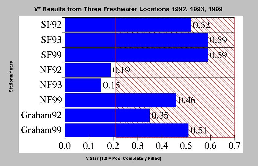
52
53
54
55
56
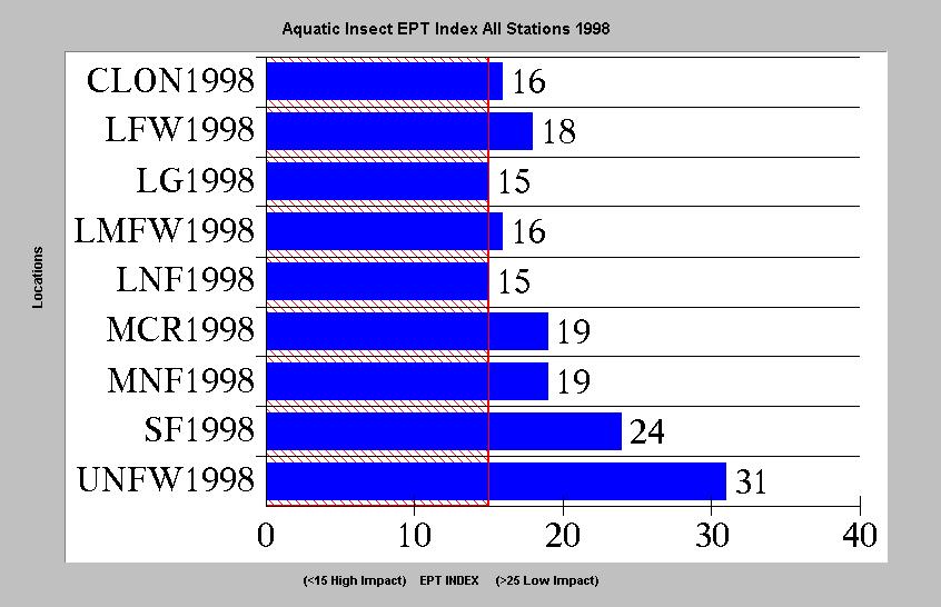
57

58

59

60

61

62

63
64
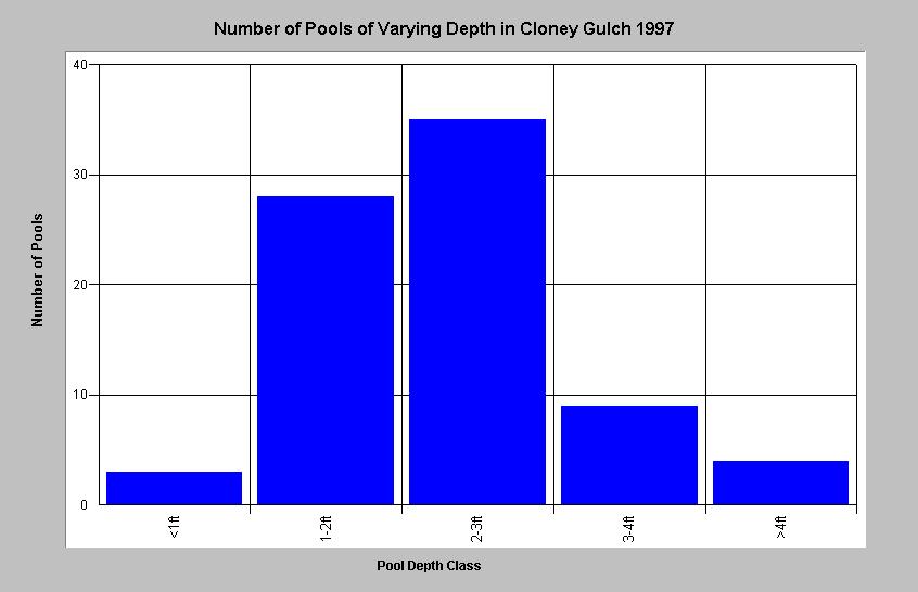
65

66

67

68

69

70

71
72

73

74
75

76

77

78

79

80
81
82

83

84
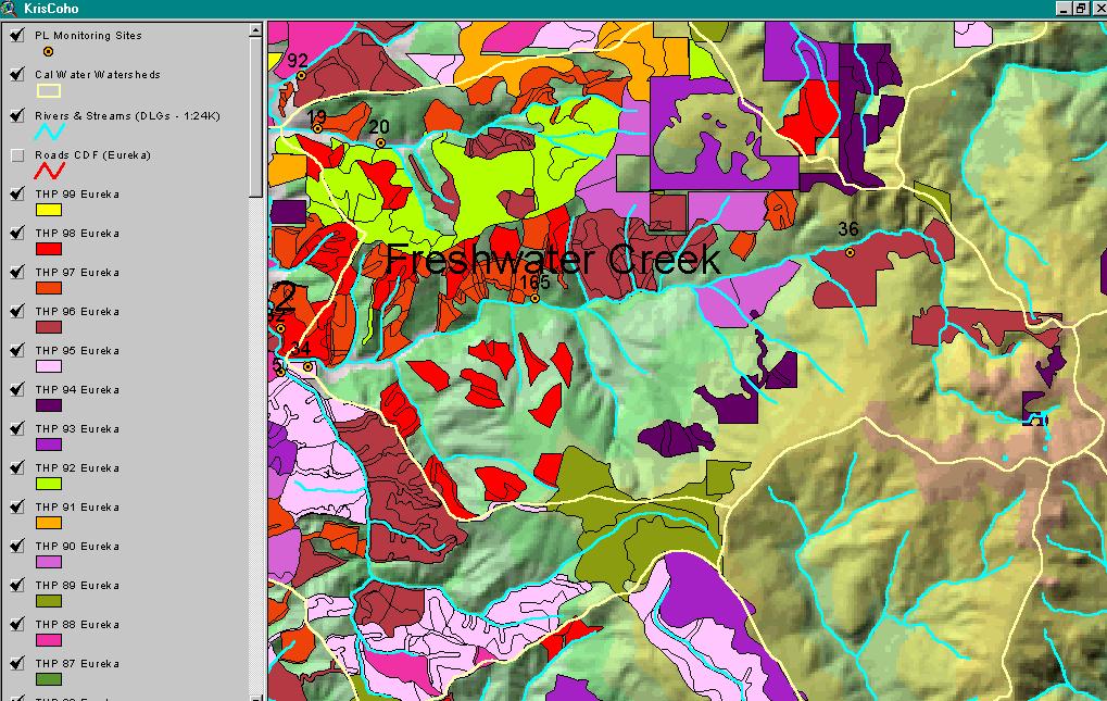
85
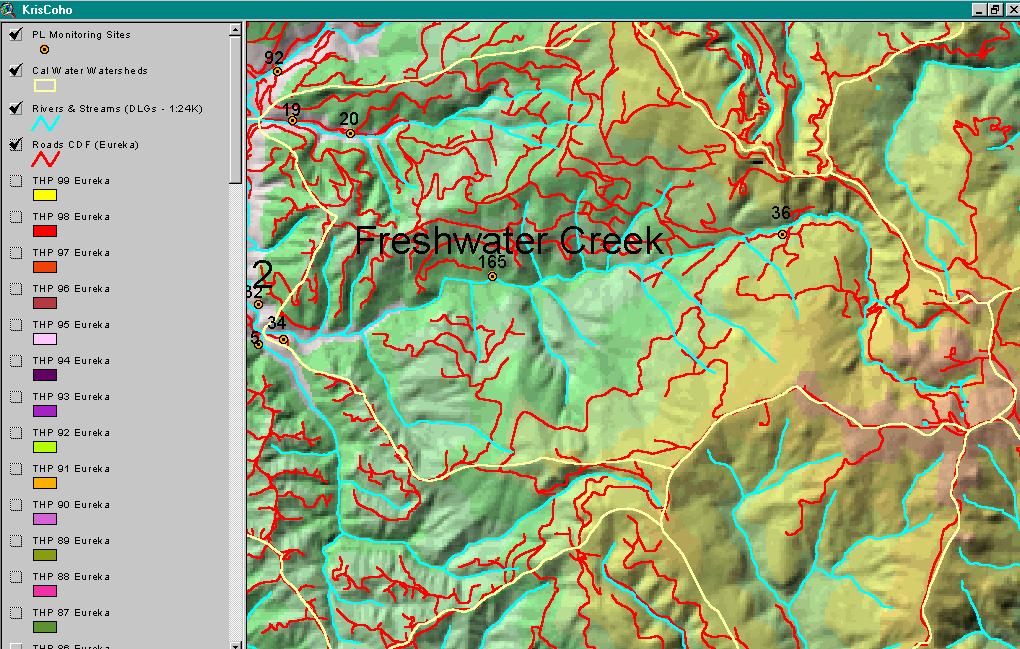
86

87

88
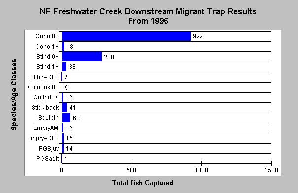
89

90

91
92

93
94

95
FISHERIES BLUE MOUNTAINS ADAPTATION PARTNERSHIP
 FISHERIES A warming climate, by itself, substantially affects the hydrology of watersheds in the Blue Mountains. Among the key hydrologic changes projected under all scenarios for the 2040s and beyond
Abundance of Steelhead and Coho Salmon in the Lagunitas Creek Drainage, Marin County, California
 scanned for KRIS Abundance of Steelhead and Coho Salmon in the Lagunitas Creek Drainage, Marin County, California Prepared for: Marin Municipal Water District 220 Nellen Drive Corte Madera, California
STEELHEAD SURVEYS IN OMAK CREEK
 STEELHEAD SURVEYS IN OMAK CREEK 2002 Annual Report Prepared by Chris Fisher John Arterburn Colville Confederated Tribes Fish and Wildlife Department P.O. Box 150 Nespelem, WA 99155 Prepared for Project
CHAPTER 4 DESIRED OUTCOMES: VISION, GOALS, AND OBJECTIVES
 CHAPTER 4 DESIRED OUTCOMES: VISION, GOALS, AND OBJECTIVES Vision One of the first steps in developing this Plan was articulating a vision - a clear statement of what the Plan strives to achieve and what
Appendix A Recommended EPA Temperature Thresholds for use in Establishing Thermal Potential and Species Life Stage Numeric Criteria
 Appendix A Recommended EPA Temperature Thresholds for use in Establishing Thermal Potential and Species Life Stage Numeric Criteria 1. Temperature Limits Recommended to Protect Salmonid Guilds In this
Juvenile Steelhead and Stream Habitat Conditions Steelhead and Coho Salmon Life History Prepared by: DW ALLEY & Associates, Fishery Consultant
 Juvenile Steelhead and Stream Habitat Conditions Steelhead and Coho Salmon Life History Prepared by: DW ALLEY & Associates, Fishery Consultant I-1. Steelhead and Coho Salmon Ecology Migration. Adult steelhead
1998 Willow Creek Downstream Migrant Trap Report. Draft. Prepared By: C. A. Walker. Lower Trinity Ranger District. Six Rivers National Forest
 1998 Willow Creek Downstream Migrant Trap Report Draft Prepared By: C. A. Walker Lower Trinity Ranger District Six Rivers National Forest September 1998 Executive Summary The downstream migrant trap was
Data Report : Russian River Basin Steelhead and Coho Salmon Monitoring Program Pilot Study
 Data Report 1999-1: Russian River Basin Steelhead and Coho Salmon Monitoring Program Pilot Study Sonoma County Water Agency 215 West College Avenue Santa Rosa, California 951 Prepared by David Cook Senior
WFC 50 California s Wild Vertebrates Jan. 11, Inland Waters (Lakes and Streams) Lisa Thompson
 Lisa Thompson") Inland Waters: Lakes and Streams WFC 50 11 January 2011 Lisa Thompson Fisheries Extension Specialist Wildlife, Fish, & Conservation Biology Department University of California, Davis Take home messages
Inland Waters: Lakes and Streams WFC 50 11 January 2011 Lisa Thompson Fisheries Extension Specialist Wildlife, Fish, & Conservation Biology Department University of California, Davis Take home messages
ACUTE TEMPERATURE TOLERANCE OF JUVENILE CHINOOK SALMON FROM THE MOKELUMNE RIVER
 ACUTE TEMPERATURE TOLERANCE OF JUVENILE CHINOOK SALMON FROM THE MOKELUMNE RIVER Charles H. Hanson, Ph.D. Hanson Environmental, Inc. SUMMARY A series of static acute tests were performed to determine the
Salmon Biology Station
 Salmon Biology Station OBJECTIVES: Students learn: Wild salmon are indicator species and keystone species whose survival is connected to the health of the watershed. o Riparian salmon need trees and trees
San Lorenzo Valley Water District, Watershed Management Plan, Final Version Part I: Existing Conditions Report
 LIST OF FIGURES Figure 1-1. Map of the San Lorenzo River watershed Figure 2-1. The Santa Cruz Mountains Bioregion Figure 2-2. Protected areas within the San Lorenzo River watershed Figure 2-3. Primary
Oregon Coast Coastal Cutthroat Trout
 Oregon Coast Coastal Cutthroat Trout Species Management Unit Description The Oregon Coast Coastal Cutthroat Trout Species Management Unit (SMU) includes all populations of cutthroat trout inhabiting ocean
Five Counties Salmonid Conservation Program - Fish Passage Design Workshop. February 2013
 Program - Aquatic Organisms and Stream Crossings Ecological Connectivity A watershed is a network of channels that drain a common boundary. Channel characteristics formed by interaction of precipitation,
STREAM SURVEY File form No..
 scanned for KRIS THE RESOURCES AGENCY OF CALIFORNIA California Department of Fish and Game STREAM SURVEY File form No.. Date: September 4, 1969. NAME: North Fork Schooner Gulch Creek COUNTY: Mendocino.
Don Pedro Project Relicensing
 Don Pedro Project Relicensing M ODESTO I RRIGATION D ISTRICT TURLOCK I RRIGATION D ISTRICT FERC PROJECT N O. 2299 Resident Fish in Don Pedro Reservoir Don Pedro Reservoir Fish Stocking (1971-Present) CDFG
Yale Reservoir Kokanee (Oncorhynchus nerka) Escapement Report 2016
 Escapement Report 2016") Yale Reservoir Kokanee (Oncorhynchus nerka) Escapement Report 2016 North Fork Lewis River Hydroelectric Project Yale FERC No. 2071 Prepared by: Jeremiah Doyle, PacifiCorp April 4, 2017 1.0 INTRODUCTION
Yale Reservoir Kokanee (Oncorhynchus nerka) Escapement Report 2016 North Fork Lewis River Hydroelectric Project Yale FERC No. 2071 Prepared by: Jeremiah Doyle, PacifiCorp April 4, 2017 1.0 INTRODUCTION
Fraser River. FISH SURVEY AND MANAGEMENT INFORMATION Jon Ewert - Aquatic Biologist (Hot Sulphur Springs)
") Fraser River FISH SURVEY AND MANAGEMENT INFORMATION Jon Ewert - Aquatic Biologist (Hot Sulphur Springs) General Information: The Fraser River is a highly diverse river offering many transitions in habitat
Fraser River FISH SURVEY AND MANAGEMENT INFORMATION Jon Ewert - Aquatic Biologist (Hot Sulphur Springs) General Information: The Fraser River is a highly diverse river offering many transitions in habitat
NATIVE FISH CONSERVATION PLAN FOR THE SPRING CHINOOK SALMON ROGUE SPECIES MANAGEMENT UNIT
 Attachment 4 NATIVE FISH CONSERVATION PLAN FOR THE SPRING CHINOOK SALMON ROGUE SPECIES MANAGEMENT UNIT Figures in Draft Plan of February 28, 27 Figure 1. Map of the Rogue River Basin. PASSAGE ESTIMATES
THE CONFEDERATED TRIBES OF THE WARM SPRINGS RESERVATION OF OREGON
 THE CONFEDERATED TRIBES OF THE WARM SPRINGS RESERVATION OF OREGON To: Branch of Natural Resources P.0. Box C, Warm Springs, Oregon 97761 Phone (541) 553-2002/2003 Fax (541) 553-1994 The Independent Science
2011 SUMMARY REPORT Juvenile Steelhead Densities in the San Lorenzo, Soquel, Aptos and Corralitos Watersheds, Santa Cruz County, CA
 211 SUMMARY REPORT Juvenile Steelhead Densities in the San Lorenzo, Soquel, Aptos and Corralitos Watersheds, Santa Cruz County, CA, Aquatic Biology Don Alley, Jerry Smith and Chad Steiner, Fishery Biologists
The Effects of Stream Adjacent Logging on Downstream Populations of Coastal Cutthroat Trout
 The Effects of Stream Adjacent Logging on Downstream Populations of Coastal Cutthroat Trout. D. S. Bateman 1, R.E. Gresswell 2, Aaron M. Berger 3, D.P. Hockman-Wert 4 and D.W. Leer 1 1 Department of Forest
BOGUS CREEK SALMON STUDIES 2002
 BOGUS CREEK SALMON STUDIES 2002 BY: JEANNINE RICHEY California Department of Fish and Game KLAMATH RIVER PROJECT 303 SOUTH STREET YREKA, CALIFORNIA 96097 (530) 842-3109 California Department of Fish and
COHO SALMON AND STEELHEAD TROUT OF JDSF. Peter Cafferata, Karen Walton and Weldon Jones 1
 COHO SALMON AND STEELHEAD TROUT OF JDSF Peter Cafferata, Karen Walton and Weldon Jones 1 Spawning and rearing habitat for anadromous fish is the dominant use of Jackson Demonstration State Forest's (JDSF)
Klamath Lake Bull Trout
 Klamath Lake Bull Trout Existing Populations The Klamath Lake Bull Trout SMU is comprised of seven existing populations and four populations classified as extinct or functionally extinct (Table 189). Populations
Executive Summary. Map 1. The Santa Clara River watershed with topography.
 Santa Clara River Steelhead Trout: Assessment and Recovery Opportunities December 2005 Prepared By: Matt Stoecker and Elise Kelley, Ph.D. University of California, Santa Barbara Prepared For: The Santa
Fish Habitat Restoration and Monitoring in Southeast Washington. Andy Hill Eco Logical Research, Inc.
 Fish Habitat Restoration and Monitoring in Southeast Washington Andy Hill Eco Logical Research, Inc. Fish Habitat Restoration and Monitoring in Southeast Washington Talk overview: Restoration projects
SECTION F FISH HABITAT CONDITION AND AQUATIC SPECIES DISTRIBUTION
 SECTION F FISH HABITAT CONDITION AND AQUATIC SPECIES DISTRIBUTION INTRODUCTION The fish species currently inhabiting the Gualala River WAU are steelhead trout (Oncorhynchus mykiss), sculpin (Cottus spp.),
CHAPTER 2 - THE COQUILLE FISHERY
 CHAPTER 2 - THE COQUILLE FISHERY TABLE OF CONTENTS A. INTRODUCTION... 2-1 FIGURE 2-1 Life Histories of Anadromous Salmonids in the Coquille River... 2-2 1. Coho Salmon... 2-2 FIGURE 2-2 Coho Packed or
SALMON FACTS. Chinook Salmon. Oncorhynchus tshawytscha
 SALMON FACTS Chinook Salmon Oncorhynchus tshawytscha Other names: king, tyee, blackmouth (immature) Average size: 10-15 lbs, up to 135 lbs Fall spawner; fall, spring, and summer runs Chinook salmon are
Redd Dewatering and Juvenile Salmonid Stranding in the Lower Feather River,
 Redd Dewatering and Juvenile Salmonid Stranding in the Lower Feather River, 2005-2006 Interim Report for NOAA Fisheries Prepared by: California Department of Water Resources Division of Environmental Services
Rogue Winter Steelhead
 Rogue Winter Steelhead Existing Populations The Rogue Winter Steelhead SMU includes eight populations within the Klamath Mountains Province (KMP) in southwest Oregon (Table 93). None of the populations
Southern Oregon Coastal Cutthroat Trout
 Species Management Unit Description Southern Oregon Coastal Cutthroat Trout The Southern Oregon Coastal Cutthroat Trout SMU includes all populations of cutthroat trout inhabiting ocean tributary streams
Blue Creek Chinook Outmigration Monitoring Technical Memorandum
 Blue Creek Chinook Outmigration Monitoring 2012 Technical Memorandum Prepared by: Andrew Antonetti and Erika Partee Yurok Tribe Fisheries Program PO Box 1027 Klamath, California 95548 In Partnership with:
OREGON DEPARTMENT OF FISH AND WILDLIFE ROGUE FISH DISTRICT REPORT
 OREGON DEPARTMENT OF FISH AND WILDLIFE ROGUE FISH DISTRICT REPORT TITLE: Upper Rogue Smolt Trapping Project, 1999 STREAM: Big Butte, Little Butte, South Fork Big Butte, Slate and West Fork Evans Creeks
ASSESSMENT OF THE STATUS OF NESTUCCA RIVER WINTER STEELHEAD
 ASSESSMENT OF THE STATUS OF NESTUCCA RIVER WINTER STEELHEAD Gary Susac and Steve Jacobs Coastal Salmonid Inventory Project Oregon Department of Fish and Wildlife August 21, 2001 INTRODUCTION This report
3. The qualification raised by the ISRP is addressed in #2 above and in the work area submittal and review by the ISRP as addressed in #1.
 Please find attached a response from The Confederated Tribes of the Warm Springs Reservation of Oregon (CTWSRO) for Project # 2008-301-00, Habitat Restoration Planning, Design and Implementation within
10 is bounded by wetlands between RM 1.8 and 3.1 on the south shore and more are scattered
 The Ozette System The Ozette watershed is made up of several lakes and large streams that combine to a total drainage area of 88.4 square miles. The most significant feature of the Ozette watershed is
 D.W. ALLEY & Associates Aquatic Biology -------------------------------------------------------------------------- 2006 Juvenile Steelhead Densities in the San Lorenzo, Soquel, Aptos and Corralitos Watersheds,
Job 1. Title: Estimate abundance of juvenile trout and salmon.
 STUDY PERFORMANCE REPORT State: Michigan Project No.: F-53-R-13 Study No.: 461 Title: Population dynamics of juvenile rainbow trout and coho salmon in Lake Superior tributaries Period Covered: April 1,
Salmon age and size at maturity: Patterns and processes
 Salmon age and size at maturity: Patterns and processes 1. Age Designation 2. Variation among populations 1. Latitude 2. Within regions 3. Within watersheds 3. Variation within populations 1. Smolt size
ELECTRO-FISHING REPORT 2016 UPPER TWEED
 ELECTRO-FISHING REPORT 2016 UPPER TWEED The electro-fishing programme carried out each summer by The Tweed Foundation is part of our management plan, which details the information that is required to manage
Hatchery Scientific Review Group Review and Recommendations
 Hatchery Scientific Review Group Review and Recommendations Willamette McKenzie Spring Chinook Salmon Population and Related Hatchery Programs January 31, 2009 Columbia River Hatchery Reform Project -
Lakelse Sockeye Recovery Program
 Lakelse Sockeye Recovery Program The Ninth Annual BC Interior Stewardship Workshop May 7 th and 8 th, 2013 DFO North Coast Resource Restoration Unit Presentation Overview History/background Stock and habitat
The Salmonid Species. The Salmonid Species. Definitions of Salmonid Clans. The Salmonid Species
 The Salmonid Species The Salmonid Species N. American salmon (2 more Asian species) Chinook ( King ) Coho ( Silver ) Sockeye Chum ( Dog ) Pink ( Humpy ) Sea-run trout Steelhead, Cutthroat, Dolly Varden
Horse Linto Creek Anadromous Monitoring Project. Funded by: SB-271 California Department of Fish and Game Agreement #P
 2000-2001 Horse Linto Creek Anadromous Monitoring Project Funded by: SB-271 California Department of Fish and Game Agreement #P0010554 Prepared By: Heidi Peura Lower Trinity Ranger District November 2001
***Please Note*** April 3, Dear advisory committee members:
 April 3, 29 Dear advisory committee members: The fifth meeting of the CHF advisory committee will be held April 13 in Grants Pass from 6:-8:3 PM, and the purpose of this document is to help committee members
NEVADA DEPARTMENT OF WILDLIFE STATEWIDE FISHERIES MANAGEMENT
 NEVADA DEPARTMENT OF WILDLIFE STATEWIDE FISHERIES MANAGEMENT FEDERAL AID JOB PROGRESS REPORTS F-20-52 2016 Lake Tahoe Rainbow Trout Study WESTERN REGION NEVADA DEPARTMENT OF WILDLIFE, FISHERIES DIVISION
Ecology of stream-rearing salmon and trout Part II
 Ecology of stream-rearing salmon and trout Part II Individual Feeding territory Habitat use Growth Movement Survival Population Population Abundance Density Variation Movement Individual Relationship between
Study Update Fish Distribution and Species Composition
 Study Update Fish Distribution and Species Composition Goals and Study Area Gain a better understanding of fish species composition and abundance in waters associated with the Packwood Lake Hydroelectric
WF4313/6413-Fisheries Management. Class 22
 WF4313/6413-Fisheries Management Class 22 Announcements Revised Schedule** November 27 th No lab work on your briefs DRAFT Due 11/30/2018 by 5pm! December 4 th Brief presentations during lab. Final Exam
MINISTRY OF ENVIRONMENT ENVIRONMENTAL STEWARDSHIP DIVISION FISH AND WILDLIFE BRANCH. Horsefly River Angling Management Plan
 MINISTRY OF ENVIRONMENT ENVIRONMENTAL STEWARDSHIP DIVISION FISH AND WILDLIFE BRANCH Horsefly River Angling Management Plan January 30 th, 2006 Area/Fishery Description The Horsefly River watershed provides
For next Thurs: Jackson et al Historical overfishing and the recent collapse of coastal ecosystems. Science 293:
 For next Thurs: Jackson et al. 2001. Historical overfishing and the recent collapse of coastal ecosystems. Science 293: 629-637. Resource: means of supplying a want or deficiency, from French resourdre
Kenai River Sockeye Escapement Goals. United Cook Inlet Drift Association
 Kenai River Sockeye Escapement Goals United Cook Inlet Drift Association 2014 Evaluating Sockeye Escapement Goals in the Kenai River Utilizing Brood Tables and Markov Tables This presentation pertains
Minnesota Department of Natural Resources Division of Fish and Wildlife Section of Fisheries. Stream Survey Report. Luxemburg Creek.
 Minnesota F-29-R(P)-24 Area 315 Study 3 March 2016 Minnesota Department of Natural Resources Division of Fish and Wildlife Section of Fisheries Stream Survey Report Luxemburg Creek 2015 Mark Pelham Sauk
NEVADA DEPARTMENT OF WILDLIFE STATEWIDE FISHERIES MANAGEMENT
 NEVADA DEPARTMENT OF WILDLIFE STATEWIDE FISHERIES MANAGEMENT FEDERAL AID JOB PROGRESS REPORT F-20-50 2014 LAHONTAN CUTTHROAT TROUT STUDY WESTERN REGION NEVADA DEPARTMENT OF WILDLIFE, FISHERIES DIVISION
NORTH RIVER FISH KILL PRELIMINARY REPORT 2014 SUMMARY
 NORTH RIVER FISH KILL PRELIMINARY REPORT 2014 SUMMARY A fish kill on Nor River was reported to e 1-800 Environmental emergency number on August 9, 2014. Representatives from e PEI Department of Environment,
Chemical and Biological Recovery from Acidic Deposition in the Honnedaga Lake Watershed
 Chemical and Biological Recovery from Acidic Deposition in the Honnedaga Lake Watershed Abstract Honnedaga Lake supports one of seven remaining heritage strains of brook trout designated by the State of
Chinook Salmon Spawning Study Russian River Fall 2005
 Chinook Salmon Spawning Study Russian River Fall 2005 Sonoma County Water Agency 2150 West College Avenue Santa Rosa, California 95401 Prepared by David Cook - Senior Environmental Specialist March 27,
Michigan Department of Natural Resources Status of the Fishery Resource Report Page 1
 Michigan Department of Natural Resources 2007-33 Status of the Fishery Resource Report Page 1 Grand Sable Lake Alger County, T49N, R14W, Sec. Many Lake Superior watershed, last year surveyed 2004 James
NEVADA DEPARTMENT OF WILDLIFE STATEWIDE FISHERIES MANAGEMENT FEDERAL AID JOB PROGRESS REPORT F STREAM FISHERIES MANAGEMENT WESTERN REGION
 NEVADA DEPARTMENT OF WILDLIFE STATEWIDE FISHERIES MANAGEMENT FEDERAL AID JOB PROGRESS REPORT F-20-50 2014 STREAM FISHERIES MANAGEMENT WESTERN REGION NEVADA DEPARTMENT OF WILDLIFE, FISHERIES DIVISION ANNUAL
Michigan Dept. of Natural Resources Status of the Fishery Resource Report Page 1. Weber Lake Cheboygan County, T34N, R3W, Sec.
 Michigan Dept. of Natural Resources 2012-143 Status of the Fishery Resource Report Page 1 Weber Lake Cheboygan County, T34N, R3W, Sec. 31 Neal Godby, Fisheries Biologist Environment Weber Lake is a 28.5-acre
Youngs Creek Hydroelectric Project (FERC No. P 10359)
") Youngs Creek Hydroelectric Project (FERC No. P 10359) Resident Trout Monitoring Plan Annual Report 2010 Survey and Results of Pre Project Monitoring Prepared by: September 2010 Overview The Public Utility
Youngs Creek Hydroelectric Project (FERC No. P 10359) Resident Trout Monitoring Plan Annual Report 2010 Survey and Results of Pre Project Monitoring Prepared by: September 2010 Overview The Public Utility
Striped Bass and White Hybrid (x) Striped Bass Management and Fishing in Pennsylvania
 Striped Bass Management and Fishing in Pennsylvania") Striped Bass and White Hybrid (x) Striped Bass Management and Fishing in Pennsylvania Prepared by R. Lorantas, D. Kristine and C. Hobbs PFBC Warmwater Unit 2005 (stocking numbers updated after 2005) Goal:
Striped Bass and White Hybrid (x) Striped Bass Management and Fishing in Pennsylvania Prepared by R. Lorantas, D. Kristine and C. Hobbs PFBC Warmwater Unit 2005 (stocking numbers updated after 2005) Goal:
Fish Survey Report and Stocking Advice for Loch Milton. (Loch a Mhuilinn), May 2011
, May 2011") Fish Survey Report and Stocking Advice for Loch Milton (Loch a Mhuilinn), May 2011 Jonah Tosney Freshwater Fisheries Biologist Wester Ross Fisheries Trust 1 Loch Milton (Loch a Mhuilinn) Fish Survey Report
Fish Survey Report and Stocking Advice for Loch Milton (Loch a Mhuilinn), May 2011 Jonah Tosney Freshwater Fisheries Biologist Wester Ross Fisheries Trust 1 Loch Milton (Loch a Mhuilinn) Fish Survey Report
State of California The Resources Agency DEPARTMENT OF FISH AND GAME
 State of California The Resources Agency DEPARTMENT OF FISH AND GAME FINAL REPORT SHASTA AND SCOTT RIVER JUVENILE SALMONID OUTMIGRATION MONITORING PROJECT Prepared for the Pacific States Marine Fisheries
State of San Francisco Bay 2011 Appendix O Steelhead Trout Production as an Indicator of Watershed Health
 State of San Francisco Bay 2011 Appendix O Steelhead Trout Production as an Indicator of Watershed Health Gordon Becker and Katherine Smetak, Center for Ecosystem Management and Restoration 290 Introduction
August 11 Snorkel SCC side channel network (SBA, SCC3) feet 707
 feet 707") Date Survey Type Habitat July 29 Snorkel (reconnaissance) Table 1. Fish use survey schedule 2004 Water temperature 1 (ºC) Estimated Mean visibility 2 discharge 3 (cfs) Mainstem (units #1 42) ND ND 814
Date Survey Type Habitat July 29 Snorkel (reconnaissance) Table 1. Fish use survey schedule 2004 Water temperature 1 (ºC) Estimated Mean visibility 2 discharge 3 (cfs) Mainstem (units #1 42) ND ND 814
ATLANTIC SALMON NEWFOUNDLAND AND LABRADOR, SALMON FISHING AREAS 1-14B. The Fisheries. Newfoundland Region Stock Status Report D2-01
 Fisheries Pêches and Oceans et Océans DFO Science Newfoundland Region Stock Status Report D2-01 ATLANTIC SALMON NEWFOUNDLAND AND LABRADOR, SALMON FISHING AREAS 1-14B Background There are 15 Atlantic salmon
Summer Steelhead Surveys North Fork Trinity River Trinity County, California
 KRIS edition Summer Steelhead Surveys North Fork Trinity River Trinity County, California 1978-1997 By Loren Everest Fishery Biologist Weaverville Ranger District Shasta-Trinity National Forests October
Alberta Conservation Association 2017/18 Project Summary Report
 Alberta Conservation Association 2017/18 Project Summary Report Project Name: Abundance, Distribution, Spawning, and Thermal Habitat of Westslope Cutthroat Trout and Bull Trout in the Stimson Creek Watershed
2012 Summary Report on the Juvenile Salmonid and Stream Habitat Monitoring Program
 2012 Summary Report on the Juvenile Salmonid and Stream Habitat Monitoring Program Prepared by: Kristen Kittleson, Fishery Resource Planner County of Santa Cruz Water Resources Program January 10, 2012
Coho. Oregon Native Fish Status Report 13
 12 Coho Coho salmon are widespread in small, low gradient streams of the coast and lower Columbia. They enter freshwater and spawn after fall rains raise river levels, typically from September through
JadEco, LLC PO BOX 445 Shannon, IL 61078
 Introduction: With the assistance of Lake Holiday staff and volunteers, we were able to conduct an AC electrofishing survey on May 8, 27. Water temperatures were 2.3 C (8.5 F) and water clarity was decent
Strategies for mitigating ecological effects of hatchery programs
 Strategies for mitigating ecological effects of hatchery programs Some case studies from the Pacific Northwest Kathryn Kostow Oregon Department of Fish and Wildlife Ecological risks occur when the presence
RIVER CONONISH INVERTEBRATE SURVEY Dr Kjersti Birkeland
 RIVER CONONISH INVERTEBRATE SURVEY 26 Dr Kjersti Birkeland Background The Cononish, the upper reaches of the River Dochart, should be very important for spring salmon but surveys by the Tay District Salmon
APPENDIX B. Final reports on chinook salmon spawning surveys - Sultan River, Washington Report
 APPENDX B Final reports on chinook salmon spawning surveys - Sultan River, Washington B-1. B-2. 1987 Report. 1988 Report APPENDX B-l Final report on 1987 chinook spawning survey - Sultan River, Snohomish
Michigan Department of Natural Resources Status of the Fishery Resource Report Page 1
 Michigan Department of Natural Resources 2008-59 Status of the Fishery Resource Report Page 1 Bowens Manistee County, (T24N R16W Sec. 11, 12, 13, 14, 15, 24, and 30). Last surveyed 2008 Mark A. Tonello
Salmon and Steelhead in the American River Tim Horner, PhD Geology Department California State University, Sacramento
 Salmon and Steelhead in the American River Tim Horner, PhD Geology Department California State University, Sacramento What kind of fish are in the American River? The American River provides habitat for
Study No. 18. Mystic Lake, Montana. PPL Montana 45 Basin Creek Road Butte, Montana 59701
 Study No. 18 Evaluation of the Current Fish Population and Habitat in West Rosebud Creek Downstream from Emerald Lake Mystic Lake Hydroelectric Project FERC No. 2301 Mystic Lake, Montana PPL Montana 45
ANNUAL PERFORMANCE REPORT FEDERAL AID IN SPORT FISH RESTORATION ACT. Grant Title: Inland and Anadromous Sport Fish Management and Research
 ANNUAL PERFORMANCE REPORT FEDERAL AID IN SPORT FISH RESTORATION ACT State: California Grant Agreement: F-51-R-13 Grant Title: Inland and Anadromous Sport Fish Management and Research Project No. 22: North
Final Bull Trout Genetics Monitoring Plan for the Wallowa Falls Hydroelectric Project. (FERC No. P-308) June 2017
 June 2017") Final for the Wallowa Falls Hydroelectric Project (FERC No. P-308) June 2017 Prepared by: Jeremiah Doyle PacifiCorp 825 NE Multnomah Street Portland, OR 97232 June, 2017 Page 1 of 8 Table of Contents 1.0
Final for the Wallowa Falls Hydroelectric Project (FERC No. P-308) June 2017 Prepared by: Jeremiah Doyle PacifiCorp 825 NE Multnomah Street Portland, OR 97232 June, 2017 Page 1 of 8 Table of Contents 1.0
Steelhead Society of BC. Thompson River Watershed Restoration and Enhancement Project #4 Nicola River Bank Stabilization and Enhancement Project
 Steelhead Society of BC Presents: Thompson River Watershed Restoration and Enhancement Project #4 Nicola River Bank Stabilization and Enhancement Project Application for Funding December 2013 1.0 BACKGROUND
5B. Management of invasive species in the Cosumnes and Mokelumne River Basins
 5B. Management of invasive species in the Cosumnes and Mokelumne River Basins Cosumnes River The Cosumnes River basin has a number of distinct habitat types that require different management strategies
Scour of Chinook Salmon Redds on Suction Dredge Tailings
 North American Journal of Fisheries Management 19:613-617, 1999 American Fisheries Society 1999 Scour of Chinook Salmon Redds on Suction Dredge Tailings BRET C. HARVEY* AND THOMAS E. LISLE Pacific Southwest
The Calawah River System
 The Calawah River System The Calawah River is the largest tributary of the Bogachiel River and is formed by the confluence of the north and south forks of the Calawah. The two forks of the Calawah, CALAWAH
Okanagan Sockeye Reintroduction
 Okanagan Sockeye Reintroduction Backgrounder Elders accounts, and other forms of Traditional Ecological Knowledge (TEK) tell us that many species of salmon once came into the Okanagan Valley and tell us
Chinook salmon (photo by Roger Tabor)
") Stream Residence 1. The choice : emigration vs. residence 2. Food: Abundance, density, and variation 3. Territory and Dominance 4. Fish Responses: Distribution, growth, survival 5. Mortality Migration
Stream Residence 1. The choice : emigration vs. residence 2. Food: Abundance, density, and variation 3. Territory and Dominance 4. Fish Responses: Distribution, growth, survival 5. Mortality Migration
Ecology of Place: What salmon need Eric Beamer Skagit River System Cooperative. November 2010
 Ecology of Place: What salmon need Eric Beamer Skagit River System Cooperative November 2010 Acknowledgements NOAA Fisheries NW Fisheries Science Center Tim Beechie George Pess Correigh Greene Talk overview
THE OREGON PLAN for. Salmon and Watersheds. Smith River Steelhead and Coho Monitoring Verification Study, Report Number: OPSW-ODFW
 THE OREGON PLAN for Salmon and Watersheds Smith River Steelhead and Coho Monitoring Verification Study, 2007 Report Number: OPSW-ODFW-2009-11 The Oregon Department of Fish and Wildlife prohibits discrimination
The Fishery. Newfoundland Region Stock Status Report D2-05
 Fisheries Pêches and Oceans et Océans DFO Science Newfoundland Region Stock Status Report D2-05 ATLANTIC SALMON INSULAR NEWFOUNDLAND, SOUTHWEST COAST, SALMON FISHING AREAS 12-13 Background Salmon Fishing
EXHIBIT ARWA-700 TESTIMONY OF PAUL BRATOVICH
 EXHIBIT ARWA-700 TESTIMONY OF PAUL BRATOVICH 1. I am a fisheries biologist employed by the firm of HDR, Inc. I hold a Bachelor of Science degree in Fisheries from the University of Washington, located
Proposed 2018 Fisheries Management Measures to Support Recovery of Interior Fraser River Steelhead
 Proposed 2018 Fisheries Management Measures to Support Recovery of Interior Fraser River Steelhead 22-March-2018 Spawning escapements of two Interior Fraser River steelhead stocks, Thompson and Chilcotin
Big Spring Creek Habitat Enhancement and Fishery Management Plans
 Big Spring Creek Habitat Enhancement and Fishery Management Plans November 5, 2012 Big Spring Events and Activities Center Newville, PA Charlie McGarrell Regional Habitat Biologist Pennsylvania Fish and
Ned Currence, Nooksack Indian Tribe
 Ned Currence, Nooksack Indian Tribe Problem Status Distribution Habitat Hatcheries Harvest 25000 20000 Natural-Origin Spawners 15000 10000 22500 5000 0 Historic catch Spawners (2011-2015) Problem Status
Fish Tech Weekly Outline January 14-18
 Fish Tech Weekly Outline January 14-18 TOPICS: salmon, trout, and char in Southeast Alaska salmonid identification overview salmonid life cycle and stages salmonid freshwater and marine distribution/residence
Sub-watershed Summaries
 Project Description The Salmon Drift Creek Watershed Council (SDCWC) has focused their efforts in the Salmon River estuary for the past few years. The multifaceted partnership effort is nearing completion
Little Kern Golden Trout Status:
 Little Kern Golden Trout Status: The Little Kern Golden trout (LKGT) was proposed for federal listing as Threatened under the Endangered Species Act (ESA) on September 1, 1977 by the U. S. Fish and Wildlife
Kootenay Lake Update and Actions Matt Neufeld and Jeff Burrows Ministry of Forests, Lands and Natural Resource Operations - Nelson
 Kootenay Lake Update and Actions 2015 Matt Neufeld and Jeff Burrows Ministry of Forests, Lands and Natural Resource Operations - Nelson History Leading to 2015 Kokanee Gerrard Rainbow Kootenay Lake Fishery
Jason Blackburn, Paul Hvenegaard, Dave Jackson, Tyler Johns, Chad Judd, Scott Seward and Juanna Thompson
 Alberta Conservation Association (ACA) Date: 2014-2015 Project Name: Owl River Walleye and Aquatic Habitat Assessment Fisheries Program Manager: Peter Aku Project Leader: Tyler Johns Primary ACA staff