TICES TO MARINERS 1 TO 46 ANNUAL EDITION 2018 SECTION A AIDS TO NAVIGATION AND MARINE SAFETY
|
|
|
- Stella Henry
- 6 years ago
- Views:
Transcription
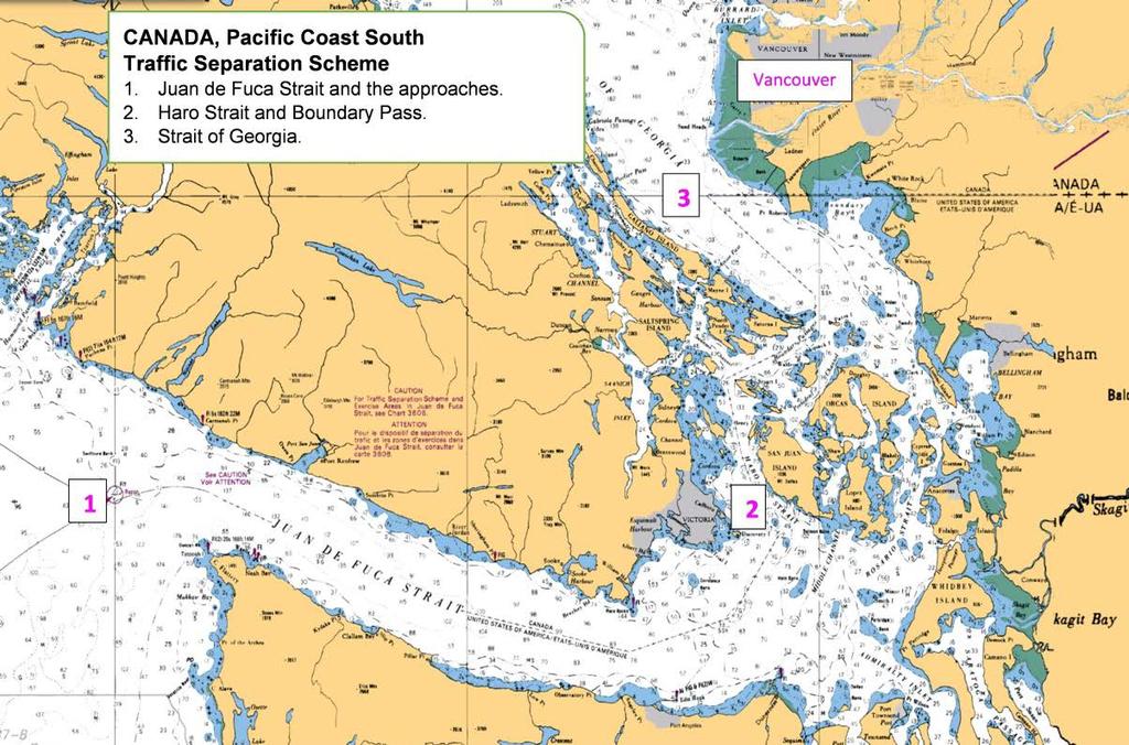
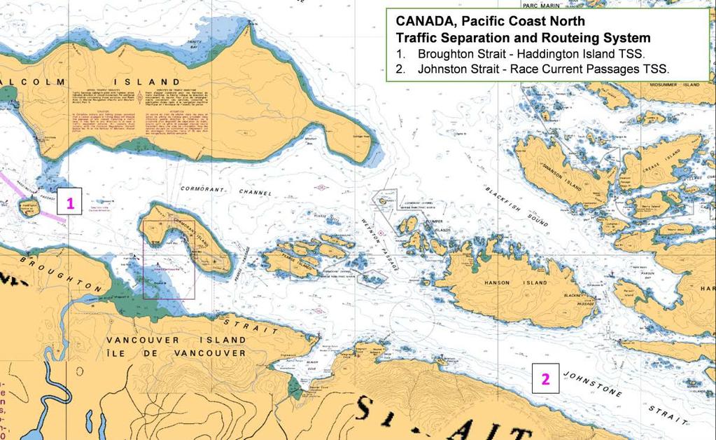
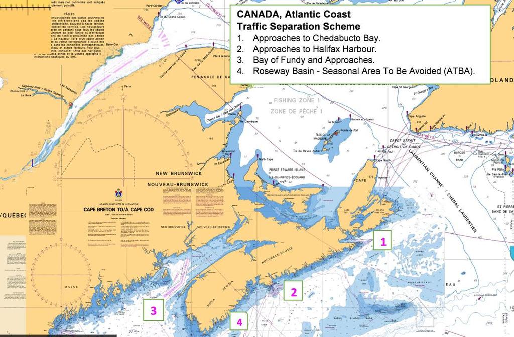
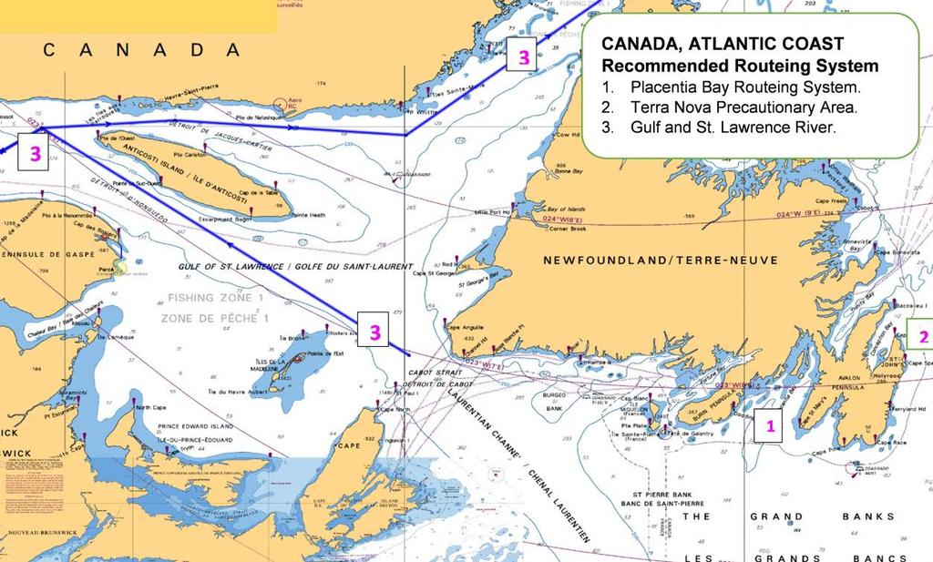
1 A5 NAVIGATION SAFETY 10 Routeing of Ships 1 GENERAL 1.1 Rule 10 of the Collision Regulations applies to all ships navigating in or near a routeing system. 1.2 The information on ships' routeing in this Notice was up-to-date at the time of printing. Monthly editions of the Notices to Mariners must be consulted for additions and amendments. ( 1.3 Ships which depart from these routes and meet with collisions may involve themselves in legal liability. Admiralty courts have held that, where traffic routeing systems are observed for the common safety of ships and are recognized on official charts, "it is negligent navigation to leave them without reason." 1.4 The Canadian compulsory routeing systems are modified by the provisions that fall under the heading "Canadian Modifications" to Rule 10 of the Collision Regulations as follows:.1 In Canadian waters and fishing zones, a vessel engaged in fishing may fish in any direction in or near a traffic separation scheme, but shall not impede the passage of any vessel following a traffic lane..2 Every power-driven vessel of more than 20 metres in length is required to use the route within a traffic separation scheme or routeing system by which it can safety proceed to its destination..3 Conditional exemptions are also made for special purpose vessels. 1.5 Detailed information on the routeing of ships, which includes traffic separation schemes, deep water routes, areas to be avoided and other routeing measures, can be found in the appropriate Sailing Directions and in the International Maritime Organization (IMO) publication titled "Ships' Routeing". 2 CANADIAN ROUTEING MEASURES 2.1 Compulsory Canadian Routeing Systems In the Approaches to Chedabucto Bay (also adopted by IMO)(amended in 2007) Reference charts: 4013, 4321, 4335 and 4374 (Canada) In the Bay of Fundy and Approaches (also adopted by IMO)(amended in 2002)R Reference charts: 4011, 4012 (Canada) In the Strait of Juan de Fuca and its Approaches (also adopted by IMO) (amended in 2005) Reference charts: 3440, 3461, 3462, 3602 and 3606 (Canada) 18400, 18421, 18440, 18460, 18465, and (United States) In Haro Straight and Boundary Pass (also adopted by IMO) Reference charts: 3461, 3462, 3440, and 3601 (Canada), 18421, 18423, 18431, and (United States). In the Strait of Georgia (also adopted by IMO)(amended in 2004) Reference charts: 3462, 3463, 3492 and 3601 (Canada), 18421, and (United States). 2.2 Recommended Canadian Routeing Systems Johnstone Strait - Race and Current Passages Traffic Separation Scheme Reference chart: 3544 (Canada) Mariners using this traffic separation scheme should be aware of the following recommendation and caution: "Mariners are recommended to use their radiotelephone to provide information of their presence and warnings to other ships. DFO/ A5 Notice 10 - Page 1
2 CAUTION In some instances a large vessel proceeding westbound on an ebb tide may have difficulty in making the turn to starboard into Current Passage and clearing Ripple Shoal. Under such circumstances the master may decide to proceed against the traffic flow through Race Passage and should make every effort to warn other traffic in the area." Broughton Strait - Haddington Island Traffic Separation Scheme Reference chart: 3546 (Canada) Mariners using this traffic separation scheme should be aware of the following recommendation and caution: "Mariners are recommended to use their radiotelephone to provide information of their presence and warnings to other ships. CAUTION In some instances large vessels and tugs with long tows proceeding eastbound may have difficulty in making the turn to starboard to pass south of Haddington Island. Under such circumstances the master may decide to proceed against the traffic flow through Haddington Passage but should make every effort to warn other traffic in the area." Vancouver and Approaches Traffic Separation Scheme Reference charts: 3463, 3481 and 3526 Gulf and River St. Lawrence Routeing System Reference charts: 1203, 1220, 1221, 1236, 1320, 4002, 4020, 4021, 4022, 4024, 4025, 4026 and 4731(Canada) System revised and in effect July 1st, Halifax and Approaches Routeing System Reference chart: 4320 (Canada) Placentia Bay Routeing System Reference charts: 4839, 4841, 4622, 4624, 4016 and 4047 (Canada) Bull Arm Routeing System Reference chart: 4851 (Canada) 2.3 Recommended Great Lakes Routeing Measures.1 The Great Lakes routeing measures consist of a system of recommended courses on Lakes Ontario, Erie, Huron, Michigan and Superior..2 These courses are delineated on both Canadian and the United States general charts of the Great Lakes, and are described in the appropriate Sailing Directions..3 In the interest of navigational safety and environmental protection, mariners are advised to observe these courses..4 The person in charge of the navigation of the ships may exercise discretion in departing from the recommended courses whenever weather or ice conditions render it necessary. 2.4 Ice Routeing Refer to Notice to Mariners No. 6 for ice routeing in Canadian waters. DFO/ A5 Notice 10 - Page 2
3 2.5 Tanker Exclusion Zone - Pacific Coast.1 A tanker exclusion zone (TEZ) has been established off the Pacific coast of Canada as a result of the discontinuance of the Trans Alaska Pipeline Tanker Routes..2 The purpose of the TEZ is to keep laden tankers west of the zone boundary in an effort to protect the shoreline and coastal waters from a potential risk of pollution..3 The zone boundary follows the Canada/Alaska border to a point approximately 115 miles west of Langara Island, thence southward to approximately 73 miles southwest of Cape St. James, thence to 40 miles southwest of Amphitrite Point and thence due east to just off Cape Flattery..4 The TEZ is defined as follows: a line from 54 00'00"N '00"W thence to 51 05'00"N '00"W thence to 48 32'00"N '00"W thence to 48 32'00"N '00"W.5 Loaded TAPS crude oil tankers transiting along the Pacific coast are requested to remain seaward of this zone boundary. 2.6 Precautionary Area Terra Nova Floating Production Storage and Offloading (FPSO) (Grand Banks of Newfoundland) Ships should navigate with particular caution in the area having a 10 nm radius centered on N ad W. Any ship planning to transit the precautionary area is advised to contact the FPSO vessel on VHF channel 16 and to comply with the instructions given while transiting the area. Ship movement in the area is monitored on a 24 hour basis. Reference Charts: 4000, 4001, 8011 and 8012 (Canada) 2.7 Area to be avoided (ATBA) Roseway Basin Seasonal ATBA (June through December) (South of Nova Scotia) Charts 4003, 4012 and 4230 (Canada) 3 International Routeing Measures 3.1 The IMO publication entitled "Ships' Routeing" contains the full details and coordinates of all IMO routeing measures and Associated Rules and Recommendations on Navigation. Details for obtaining this IMO publication can be found in Notice to Mariners No. 14. The appropriate Sailing Directions should also be referred to for additional information. 4 Use of Routeing Systems 4.1 Routeing systems are intended for use by day and by night in all weather, in ice free waters or under light ice conditions where no extraordinary maneuvers or icebreaker assistance are required. 4.2 Routeing systems are recommended for use by all ships unless stated otherwise. Bearing in mind the need for adequate under-keel clearance, a decision to use a routeing system must take into account the charted depth, the possibility of changes in the sea-bed since the time of the last survey, and the effects of meteorological and tidal conditions on water depths. 4.3 A ship navigating in or near a traffic separation scheme shall in particular comply with Rule 10 of the Collision Regulations to minimize the development of risk of collision with another ship. The other rules of the Collision Regulations apply in all respects, and particularly the rules of part B, sections II and III, if risk of collision with another ship is deemed to exist. DFO/ A5 Notice 10 - Page 3
4 4.4 At junction points where traffic from various directions meet, a true separation of traffic is not really possible, as ships may need to cross routes or change to another route. Ships should therefore navigate with great caution in such areas and be aware that the mere fact that a ship is proceeding along a through - going route gives that ship no special privilege or right of way. 4.5 A deep-water route is primarily intended for use by ships which, because of their draught in relation to the available depth of water in the area concerned, require the use of such a route. Through traffic to which the above consideration does not apply should, as far as practicable, avoid using deep-water routes. A deepwater route is a route within defined limits which has been surveyed for clearance of sea bottom and submerged obstacles as indicated on a chart. 4.6 A precautionary area should be avoided, if practicable, by passing ships not making use of the associated traffic separation schemes or deep-water routes, or entering or leaving adjacent ports. A precautionary area is an area within defined limits where ships must navigate with particular caution and within which the direction of traffic flow may be recommended. 4.7 In a two-way route, including two-way deep-water route, ships should as far as practicable keep to the starboard side. A two-way route is a route within defined limits inside which two-way traffic is established. The aim is to provide safe passage of ships through waters where navigation is difficult or dangerous. Authority: Transport Canada DFO/ A5 Notice 10 - Page 4
5 DFO/ A5 Notice 10 - Page 5
6 DFO/ A5 Notice 10 - Page 6
 3 Recommended track based on a system of fixed marks 4 Recommended track not based on a system of")
7 Symbol for basic element of routeing measures Unless otherwise specified symbols are printed on charts in colour, usually magenta. Tracks Ref. Description CHS Symbology 1 Leading line (solid line is the track to be followed; means "in line") 3 Recommended track based on a system of fixed marks 4 Recommended track not based on a system of fixed marks 5.1 One-way track (and DW track) based on a system of fixed marks 5.2 One-way track (and DW track) not based on a system of fixed marks a Two-way track DFO/ A5 Notice 10 - Page 7
8 Routeing Measures Ref. Description CHS Symbology 10 Established (mandatory) direction of traffic flow 11 Recommended direction of traffic flow 12 Separation line (large- scale, smaller scale) 13 Separation zone 14 Limit of restricted routeing measure 15 Limit of routeing measure 16 Precautionary area Chart 1 provides explanations of the symbols, abbreviations and terms used in CHS nautical charts. HTML and PDF versions of Chart 1 are maintained for update. NOTES 1. Arrows dispersed over width of route. Arrows may be curved. Where the traffic lane is converging, arrows should be oriented to the approximate average directions of the side boundaries. 2. Arrow omitted at intersections (other than roundabouts) to avoid implying priority of one lane. 3. Separation line 3 mm wide where chart scale permits. 4. Tint light enough not to obscure detail beneath it. 5. If traffic lanes are separated by natural obstacles, may be replaced by the symbol for general maritime limits at the boundaries of the lanes. 6. Stems of dashes pointing towards the area in question. 7. Symbol intended for tracks to be followed closely through inadequately surveyed areas. DFO/ A5 Notice 10 - Page 8
ROUTEING MEASURES OTHER THAN TRAFFIC SEPARATION SCHEMES
 E 4 ALBERT EMBANKMENT LONDON SE1 7SR Telephone: +44 (0)20 7735 7611 Fax: +44 (0)20 7587 3210 SN.1/Circ.317 4 December 2012 ROUTEING MEASURES OTHER THAN TRAFFIC SEPARATION SCHEMES 1 The Maritime Safety
GUIDELINES FOR NAVIGATION UNDER THE CONFEDERATION BRIDGE
 (12/2009) GUIDELINES FOR NAVIGATION UNDER THE CONFEDERATION BRIDGE REVISION 1 DECEMBER 2009 Responsible Authority The Regional Director Marine Safety Atlantic Region is responsible for this document, including
Harbourmaster s Office Tamaki River. Navigation Safety Operating Requirements 2014
 Harbourmaster s Office Tamaki River Navigation Safety Operating Requirements 2014 Auckland Council Harbourmaster s Office TAMAKI RIVER Navigation Safety Operating Requirements FOREWARD The purpose of these
Convention on the International Regulations for Preventing Collisions at Sea, 1972 (COLREGs) EXPLANATORY NOTES
 EXPLANATORY NOTES") Convention on the International Regulations for Preventing Collisions at Sea, 1972 (COLREGs) EXPLANATORY NOTES Adoption: 20 October 1972 Entry into force: 15 July 1977 Introduction Amendment procedure
Convention on the International Regulations for Preventing Collisions at Sea, 1972 (COLREGs) EXPLANATORY NOTES Adoption: 20 October 1972 Entry into force: 15 July 1977 Introduction Amendment procedure
THE REPUBLIC OF LIBERIA LIBERIA MARITIME AUTHORITY
 Office of Deputy Commissioner of Maritime Affairs THE REPUBLIC OF LIBERIA LIBERIA MARITIME AUTHORITY Marine Notice NAV-003 Rev. 06/12 TO: SUBJECT: ALL SHIPOWNERS, OPERATORS, MASTERS AND OFFICERS OF MERCHANT
NEW AND AMENDED EXISTING TRAFFIC SEPARATION SCHEMES
 INTERNATIONAL MARITIME ORGANIZATION 4 ALBERT EMBANKMENT LONDON SE1 7SR Telephone: 020 7587 3152 Fax: 020 7587 3210 IMO E Ref. T2-OSSHE/2.7.1 COLREG.2/Circ.57 26 May 2006 NEW AND AMENDED EXISTING TRAFFIC
HELSINKI COMMISSION HELCOM SAFE NAV 4/2014 Group of Experts on Safety of Navigation Fourth Meeting Helsinki, Finland, 4 February 2014
 HELSINKI COMMISSION HELCOM SAFE NAV 4/2014 Group of Experts on Safety of Navigation Fourth Meeting Helsinki, Finland, 4 February 2014 Agenda Item 3 Accidents and ship traffic in the Baltic Sea Document
SECTION XI - COAST PILOT UPDATING. 1. To acquire a general knowledge of the responsibilities of the Auxiliary in COAST PILOT UPDATING activities.
 SECTION XI - COAST PILOT UPDATING INTRODUCTION: The United States Coast Pilot published by the NOS-C&GS, is a series of volumes that supplement the navigational data shown on nautical charts. Sources for
Introduction of the term Traffic Control Zone and formalization of Fraser River Traffic Control Zone procedures
 Consideration Report Introduction of the term Traffic Control Zone and formalization of Fraser River Traffic Control Zone procedures Background Under the Canada Marine Act, all Canada Port Authorities
SAFE PASSAGE THE STRAITS OF MALACCA AND SINGAPORE. CF6-6.7.a the 6 th Co-Operation Forum 7-8 October 2013, Bali, Indonesia DRAFT CONTENT TEXT
 CF6-6.7.a the 6 th Co-Operation Forum 7-8 October 2013, Bali, Indonesia DRAFT CONTENT TEXT VER. 24 September 2013 SAFE PASSAGE THE STRAITS OF MALACCA AND SINGAPORE 1 INTRODUCTION Today, the Straits of
Visiting Lake Macquarie
 Visiting Lake Macquarie Lake Macquarie is the largest coastal salt water lake in Australia and is a prime boating destination for both small and large vessels. Many sailing regattas and fishing activities
International regulations and guidelines for maritime spatial planning related to safe distances to multiple offshore structures (e.g.
 International regulations and guidelines for maritime spatial planning related to safe distances to multiple offshore structures (e.g. wind farms) Introduction This is a summary of the most important international
Delaware River Vessel Reporting System Mariners Advisory Committee For
 Delaware River Vessel Reporting System Mariners Advisory Committee For the Bay and River Delaware The Mariner's Advisory Committee is comprised of Master Mariners, River Pilots, and concerns itself with
PILOTAGE INFORMATION
 PILOTAGE INFORMATION Revised A PILOTAGE DIRECTIONS The Gloucester Harbour Trustees is the Competent Harbour Authority for the Gloucester Harbour under the Pilotage Act 1987 and responsible for the provision
National Maritime Center
 National Maritime Center Providing Credentials to Mariners U.S.C.G. Merchant Marine Exam (Sample Examination) Page 1 of 22 U.S.C.G. Merchant Marine Exam: Illustrations: 10 Choose the best answer to the
CHAPTER I SUEZ CANAL NAVIGATION FEATURES SECTION 1 APPROACHES
 CHAPTER I SUEZ CANAL NAVIGATION FEATURES --------------------- SECTION 1 APPROACHES Art. 8 - PORT SAID: (See Admiralty Charts No. 234, 240 & 241 GENERAL: The Vessels coming from see fifteen miles before
NOTICES TO MARINERS 1 to 46 ANNUAL EDITION 2018
 NOTICES TO MARINERS 1 to 46 CANADIAN COAST GUARD www.notmar.gc.ca Notices to Mariners 1 to 46 Annual Edition 2018 Published under the authority of: Canadian Coast Guard Programs Aids to Navigation and
IMO ROUTEING OF SHIPS, SHIP REPORTING AND RELATED MATTERS
 INTERNATIONAL MARITIME ORGANIZATION E IMO SUB-COMMITTEE ON SAFETY OF NAVIGATION 52nd session Agenda item 3 NAV 52/3/9 13 April 2006 Original: ENGLISH ROUTEING OF SHIPS, SHIP REPORTING AND RELATED MATTERS
Gorgon - Pilotage - Passage Plan Materials Offloading Facility (MOF) to PBG
 to PBG") Gorgon - Pilotage - Passage Plan Materials Offloading Facility (MOF) to PBG 1.0 Introduction Vessels transiting within port limits from the Materials Offloading Facility (MOF) to the Barrow Island Pilot
Gorgon - Pilotage - Passage Plan Materials Offloading Facility (MOF) to PBG 1.0 Introduction Vessels transiting within port limits from the Materials Offloading Facility (MOF) to the Barrow Island Pilot
World Shipping Council. National Oceanographic and Atmospheric Administration
 Comments of the World Shipping Council Submitted to the National Oceanographic and Atmospheric Administration In the matter of Endangered and Threatened Species; Petition for Rulemaking to Establish a
All comments received will be taken into consideration before the proposed amendments are implemented.
 Notice of Amendment Port Information Guide Notification date: February 13 th, 2018 Preamble In accordance with the Canada Marine Act, 1998, Section 57 Notice, the Vancouver Fraser Port Authority is proposing
Appendix 12: Marine Transportation Study. (Gartner Lee Ltd. 2008)
") Appendix 12: Marine Transportation Study (Gartner Lee Ltd. 2008) memorandum to: John Woods, Minas Basin Pulp and Power Co. Ltd from: Joseph Kozak date: ref: GLL 80308 re: FINAL Technical Marine Transportation
Appendix 12: Marine Transportation Study (Gartner Lee Ltd. 2008) memorandum to: John Woods, Minas Basin Pulp and Power Co. Ltd from: Joseph Kozak date: ref: GLL 80308 re: FINAL Technical Marine Transportation
ADANI PORTS & SEZ LTD. ++ MUNDRA PORT ++ GENERAL INFORMATION
 ADANI PORTS & SEZ LTD. ++ MUNDRA PORT ++ GENERAL INFORMATION LOCATION Mundra Port is all weather, independent, commercial port with geographical and hydrological advantages on the West Coast of India,
The factor contributing to this higher-risk area for laden tankers, cargo. ships, and passenger vessels is mainly the lack of rescue tugs at
 Laden Tankers/Cargo/Passenger Vessels -- Alaska Homer Seward Cordova Yakutat Glacier Bay Sitka Craig The factor contributing to this higher-risk area for laden tankers, cargo ships, and passenger vessels
RESOLUTION A.817(19) adopted on 23 November 1995 PERFORMANCE STANDARDS FOR ELECTRONIC CHART DISPLAY AND INFORMATION SYSTEMS (ECDIS)
 adopted on 23 November 1995 PERFORMANCE STANDARDS FOR ELECTRONIC CHART DISPLAY AND INFORMATION SYSTEMS (ECDIS)") A 19/Res.817 15 December 1996 Original: ENGLISH ASSEMBLY 19th session Agenda item 10 RESOLUTION A.817(19) adopted on 23 November 1995 PERFORMANCE STANDARDS FOR ELECTRONIC CHART DISPLAY AND INFORMATION
A 19/Res.817 15 December 1996 Original: ENGLISH ASSEMBLY 19th session Agenda item 10 RESOLUTION A.817(19) adopted on 23 November 1995 PERFORMANCE STANDARDS FOR ELECTRONIC CHART DISPLAY AND INFORMATION
Chart Specifications of the IHO Publication S-4 (Formerly M-4)
") TWLWG3/4/11A Publication S-4 (Formerly M-4) Attached to this document is an extract from IHO Publication S-4 which relate to Tidal and Water Level Information. The TWLWG is requested to review this information
TWLWG3/4/11A Publication S-4 (Formerly M-4) Attached to this document is an extract from IHO Publication S-4 which relate to Tidal and Water Level Information. The TWLWG is requested to review this information
STANDARDIZATION MARINERS' ROUTEING GUIDES. Edition April Publication S-49
 INTERNATIONAL HYDROGRAPHIC ORGANIZATION STANDARDIZATION of MARINERS' ROUTEING GUIDES Edition 2.0.0 April 2010 Publication S-49 Published by the INTERNATIONAL HYDROGRAPHIC BUREAU MONACO 4bis, Quai Antoine
OSAKA MARTIS USER MANUAL TABLE OF CONTENTS
 OSAKA MARTIS USER MANUAL TABLE OF CONTENTS Ⅰ Ⅱ Ⅲ INTRODUCTION OPERATIONAL CONCEPT OF "Osaka MARTIS" IMPORTANT NAVIGATIONAL RULES Ⅳ COMMUNICATION 1 VHF Channels 2 Language Ⅴ PRE-ENTRY REPORT AND POSITION
1972 Collision Regulations definition of a vessel. Note: Vessel length is measured from end to end over the deck, excluding sheer.
 User Definitions VMRS (Vessel Movement Reporting System) Users: Every power-driven vessel of 40 meters (approximately 131 feet) or more in length, while navigating; Every commercial vessel engaged in towing
Gorgon - Pilotage - Passage Plan PBG to Materials Offloading Facility (MOF)
") 1.0 Introduction Vessels transiting within port limits from the Barrow Island Pilot Boarding Ground (PBG) to the require an approved passage plan which can be shared between Pilots and vessel Masters.
1.0 Introduction Vessels transiting within port limits from the Barrow Island Pilot Boarding Ground (PBG) to the require an approved passage plan which can be shared between Pilots and vessel Masters.
River Tay. Passage Plan
 River Tay Passage Plan Inward and Outward Passage Plan For the River Tay within the Port of Dundee Pilotage Area. This plan has been prepared with the co-operation of personel from The Association of Dundee
THE SYLLABUS FOR WRITTEN EXAMINATION PILOT'S FOURTH CLASS LICENCE (TEES AND HARTLEPOOL) AND
 AND") PD TEESPORT CONSERVANCY DIVISION HARBOUR MASTER'S OFFICE THE SYLLABUS FOR WRITTEN EXAMINATION IN RESPECT OF A PILOT'S FOURTH CLASS LICENCE (TEES AND HARTLEPOOL) AND PILOTAGE EXEMPTION CERTIFICATE (Issued
PD TEESPORT CONSERVANCY DIVISION HARBOUR MASTER'S OFFICE THE SYLLABUS FOR WRITTEN EXAMINATION IN RESPECT OF A PILOT'S FOURTH CLASS LICENCE (TEES AND HARTLEPOOL) AND PILOTAGE EXEMPTION CERTIFICATE (Issued
MARINER S GUIDE TO THE FORTH
 MARINER S GUIDE TO THE FORTH INTRODUCTION 1. The Statutory Harbour Authority s area of jurisdiction on the River and Firth of Forth ( The Forth ) extends from approximately one mile west of the Isle of
properly applied assessment in the use.1 landmarks.1 approved in-service of ECDIS is not experience The primary method of fixing required for those
 STCW Code Table A-II/3 Specification of minimum standard of for officers in charge of a navigational watch and for masters on ships of less than 500 gross tonnage engaged on near-coastal voyages Ref: https://www.edumaritime.net/stcw-code
ADMINISTRATIVE INSTRUCTION No. STCW-14 QUALIFICATION / CERTIFICATION REQUIRED FOR OPERATION OF A DOMESTIC VESSESL
 ADMINISTRATIVE INSTRUCTION No. STCW-14 QUALIFICATION / CERTIFICATION REQUIRED FOR OPERATION OF A DOMESTIC VESSESL (Issued under section 3(5) of the Gibraltar Merchant Shipping (Safety etc.) Ordinance 1993
Wexford Harbour. Yachting Guide. Navigation
 Wexford Harbour Yachting Guide Navigation This document supersedes all previous editions. Approvals: Yacht Club Committee April, 2015 Wexford Board of Directors April, 2015 # Date Section Revision 1 6.5.2015
Gorgon - Pilotage - Passage Plan - Gorgon Marine Terminal to PBG Alternative Route
 Gorgon - Pilotage - Passage Plan - Gorgon Operating Procedure - Gorgon - Pilotage - Passage Plan - Gorgon 1.0 Introduction Vessels transiting within port limits from the Gorgon Marine Terminal
Port of Barrow Island - Local Knowledge Certificate Examination
 Port of Barrow Island - Local Knowledge 1.0 Introduction Safe navigation within the Port of Barrow Island requires significant local knowledge of navigation, communications, pilotage and operational procedures.
A GUIDE TO CANADA S BALLAST WATER CONTROL AND MANAGEMENT REGULATIONS
 (11/2007) A GUIDE TO CANADA S BALLAST WATER CONTROL AND MANAGEMENT REGULATIONS EDITION 7 19 NOVEMBER 2007 TC-1002399 *TC-1002399* Responsible Authority The Director Operations and Environmental Programs
This direction contains the requirements for the compulsory pilotage areas within the Auckland region. This
 Harbourmaster s Direction 2-15 Pilotage Foreword This direction contains the requirements for the compulsory pilotage areas within the Auckland region. This direction updates and supersedes previous Harbourmaster
The Maritime Law Association of Australia and New Zealand
 The Maritime Law Association of Australia and New Zealand Protecting the Environment and Promoting Safe Navigation: Australia s System of Pilotage in the Torres Strait Adam McCarthy Assistant Secretary
CANADIAN MARINE PILOTS ASSOCIATION ATLANTIC REGION
 June 20, 2013 Capt. Gordon Houston Chairman Tanker Safety Expert Panel Tanker Safety Panel Secretariat 330 Sparks Street, Place de Ville, Tower C (AAM) Ottawa, ON K1A 0N5 Dear Capt. Houston, We are pleased
Gorgon - Pilotage - Passage Plan - PBG to Gorgon Marine Terminal - Alternative Route
 1.0 Introduction This work instruction outlines the passage plan to be used by vessels transiting from the Port of Barrow Island PBG to the Gorgon Marine Terminal, via the alternative route, with a Pilot
PORT INFO GENERAL BERTH INFO
 s ervices SHIPWRIGHT WWW.SHIPWRIGHTSERVICES.CO.ZA 9 DE DUINE CLOSE, BLUEWATERBAY, SALDANHA, 7395, WESTERN CAPE, SOUTH AFRICA TEL. +27 71 040 6022 EMAIL. DERICK@SHIPWRIGHTSERVICES.CO.ZA PORT INFO GENERAL
Rule 18 - Responsibilities between vessels
 Except where Rules 9, 10 and 13 otherwise require: (a) A power-driven vessel underway shall keep out of the way of: (i) a vessel not under command; (ii) a vessel restricted in her ability to manoeuvre;
Required knowledge for Cook Strait endorsement
 Required knowledge for Cook Strait endorsement Last updated: March 2018 This document is uncontrolled if printed, please refer to the Maritime New Zealand website for the latest version. Cook Strait is
SECTION II NM 26/10 NAVIGATION PUBLICATIONS ALMANACS CORRECTIONS
 NAVIGATION PUBLICATIONS ALMANACS CORRECTIONS NAUTICAL ALMANAC Ed 2011 NEW EDITION (NGA) 26/10 SAILING DIRECTIONS CORRECTIONS PUB 140 8 Ed 2010 NEW EDITION (NGA) 26/10 COAST PILOT CORRECTIONS COAST PILOT
Dr Sam BATEMAN, Australian National Centre for Ocean Resources and Security, University of Wollongong
 Dr Sam BATEMAN, Australian National Centre for Ocean Resources and Security, University of Wollongong sbateman@uow.edu.au Coastal State regulation of navigation in adjacent waters is increasing Shipping
These restrictions are a combination of static zone and dynamic speed reduction sectors. (See map below)
") TP 3231 E SHIP SAFETY BULLETIN Bulletin No.: 06/2018 RDIMS No.: 14002353 Date: 2018-05-15 Y - M - D We issue Ship Safety Bulletins for the marine community. Visit our Website at www.tc.gc.ca/ssb-bsn to
TP 3231 E SHIP SAFETY BULLETIN Bulletin No.: 06/2018 RDIMS No.: 14002353 Date: 2018-05-15 Y - M - D We issue Ship Safety Bulletins for the marine community. Visit our Website at www.tc.gc.ca/ssb-bsn to
Transport Infrastructure Act 1994 Gladstone Ports Corporation. Port Notice 04/17 LNG Vessel Operating Parameters
 Transport Infrastructure Act 1994 Gladstone Ports Corporation Port Notice 04/17 LNG Vessel Operating Parameters 1. These operating parameters have been developed based on navigation simulations with LNG
World Shipping Council. Bureau of Ocean Energy Management Department of the Interior
 Comments of the World Shipping Council Submitted to the Bureau of Ocean Energy Management Department of the Interior In the matter of Commercial Leasing for Wind Power Development on the Outer Continental
Forth Ports Limited. Port of Dundee. Marine Guidelines and Port Information
 Forth Ports Limited Port of Dundee Marine Guidelines and Port Information LIST OF AMENDMENTS DATE PAGE NUMBER 22 NEW EDITION 7 March 2016 Ruling Depths 18 23 rd Application updated 3 23 rd - Tug fleet
DISCUSSION PAPER: NEW GENERALISATION POLICY FOR SMALL SCALE ADMIRALTY CHARTS.
 DISCUSSION PAPER: NEW GENERALISATION POLICY FOR SMALL SCALE ADMIRALTY CHARTS. PREFACE. Throughout this paper we will be making reference to largest scale, second scale, third scale coverage on an SNC (Standard
LIST OF CORRECTIONS. 02 / January /052(T) - 07/125(T) - 08/136(T) - 08/137(T) - 12/177(T) - 15/212(T) - 18/232-22/285(T)
 - 07/125(T) - 08/136(T) - 08/137(T) - 12/177(T) - 15/212(T) - 18/232-22/285(T)") LIST OF CORRECTIONS 105 Chart Kanaal van Gent naar Terneuzen Edition 2016 Updated up to and including NMs 02 / 2018 18 January 2018 The last version of these corrections are available on www.vlaamsehydrografie.be
LIST OF CORRECTIONS 105 Chart Kanaal van Gent naar Terneuzen Edition 2016 Updated up to and including NMs 02 / 2018 18 January 2018 The last version of these corrections are available on www.vlaamsehydrografie.be
Adverse Weather and Management of Vessel Traffic
 Adverse Weather and Management of Vessel Traffic VTS PRINCE WILLIAM SOUND LT Allie Ferko, VTS Director 01 May 2014 Vessel Movement Reporting System 33CFR161.16 VMRS Users are defined as: Power driven vessels
Whitstable Harbour Pilotage Information
 Whitstable Harbour Pilotage Information (Issue 4 October 2014) Contents 1. Pilotage Services 2. Pilotage Directions 3. Pilotage Directions - Supporting Information 4. Passage Plan 5. Pilotage Recruitment
Appendix HK1 HKSF Prescriptions
 Appendix HK1 HKSF Prescriptions Introduction Effective date Rule The HKSF prescribes that these rules become effective in Hong Kong on 1 January 2017. Prescription 67 Damages 1 No claim for damages arising
PILOTAGE DIRECTIONS REVIEWED DECEMBER 2016
 PILOTAGE DIRECTIONS REVIEWED DECEMBER 2016 REVISION LIST Revision No. Date Details Approved by: Original All sections 12 Dec 2013 First edition of C W Brand v1.0 Pilotage Directions Revision 2 all sections
2005 ABC. Chapter 3 Part 2. Navigating with ATON's. Revision to D-13 Local Notes. Instructor Notes for Mike Brough. Mike Brough
 2005 ABC Chapter 3 Part 2 Navigating with ATON's Revision to D-13 Local Notes Instructor Notes for Mike Brough Mike Brough June 24 2008 June 24 2008 Slide 1 June 24 2008 New graphics Navigating on Water
AK-APC-NTV Operating Procedures for Cargo and Passenger Non Tank Vessels Transiting and Operating in Alaska Waters December 26, 2015
 AK-APC-NTV Operating Procedures for Cargo and Passenger Non Tank Vessels Transiting and Operating in Alaska Waters December 26, 2015 The Alternative Planning Criteria (APC) Operating Procedures were developed
Gorgon Pilotage Passage Plan - PBG to Gorgon Marine Terminal Primary Route
 Gorgon Pilotage Passage Plan - PBG to Gorgon Marine Terminal Primary Route 1.0 Introduction Vessels transiting within port limits from the Barrow Island Outer Pilot Boarding Ground (PBG) to the Gorgon
PROJECT 1 REMOVAL OF WRECKS IN THE TRAFFIC SEPARATION SCHEME IN THE STRAITS OF MALACCA AND SINGAPORE OBJECTIVE. Generally to enhance the safety of
 PROJECT 1 REMOVAL OF WRECKS IN THE TRAFFIC SEPARATION SCHEME IN THE STRAITS OF MALACCA AND SINGAPORE OBJECTIVE Generally to enhance the safety of navigation in the Straits of Malacca and Singapore (Straits)
NIGERIAN NOTICES TO MARINERS November 2017 EDITION PUBLISHED BY THE HYDROGRAPHIC OFFICE LAGOS. Notice 01 November 2017 Supplied Gratis
 NIGERIAN NOTICES TO MARINERS November 2017 EDITION PUBLISHED BY THE HYDROGRAPHIC OFFICE LAGOS Notice 01 November 2017 Supplied Gratis November 2017 CONTENTS I II Explanatory Notes and Index Nigerian Navy
National Maritime Center
 National Maritime Center Providing Credentials to Mariners (Sample Examination) Page 1 of 16 Choose the best answer to the following Multiple Choice Questions. 1. On U.S. charts, you can tell if a named
Chapter 8. Port hand buoy. Starboard hand buoy. Canadian Aids to Navigation System (CANS) 8.1 Introduction. 8.2 Lateral Buoys
 8.1 Introduction. 8.2 Lateral Buoys") Chapter 8 Canadian Aids to Navigation System (CANS) 8.1 Introduction Various buoys, beacons and signs are known as "Aids to Navigation" or "Navigation Aids". They are devices or systems external to the
Chapter 8 Canadian Aids to Navigation System (CANS) 8.1 Introduction Various buoys, beacons and signs are known as "Aids to Navigation" or "Navigation Aids". They are devices or systems external to the
Rules Practice Exam 5
 1 BOTH INTERNATIONAL & INLAND Vessel "A" (towing) and vessel "B" are meeting as shown. In this situation, which statement is TRUE? Diagram 12 A. Both vessels should alter course to starboard and pass port
Chart Features Maritime maps and Admiralty charts have these features:
 Introduction to Charts A chart or map of the area is an important safety item to carry on board. It allows the Master to obtain knowledge of the area to be travelled, and indicates the navigable channels
SWIFTSURE INTERNATIONAL YACHT RACE May 27-29, 2017 Victoria, British Columbia NOTICE OF RACE
 SWIFTSURE INTERNATIONAL YACHT RACE May 27-29, 2017 Victoria, British Columbia Hosted by The Royal Victoria Yacht Club NOTICE OF RACE FOR THE FOUR LONG COURSES (THE SWIFTSURE LIGHTSHIP CLASSIC, THE HEIN
Vessel Traffic in the Salish Sea Mitigating Risk... Captain Joe Raymond Coast Sector Puget Sound
 Vessel Traffic in the Salish Sea Mitigating Risk.... Captain Joe Raymond Coast Sector Puget Sound Overview Prevention Waterways Management Oil Spill Data Mitigating Risks Sector Puget Sound AOR Blan k
Scientific Journal of Silesian University of Technology. Series Transport Zeszyty Naukowe Politechniki Śląskiej. Seria Transport
 Scientific Journal of Silesian University of Technology. Series Transport Zeszyty Naukowe Politechniki Śląskiej. Seria Transport Volumme 92 2016 p-issn: 0209-3324 e-issn: 2450-1549 DOI: 10.20858/sjsutst.2016.92.12
WAK-APC-T Operating Procedures for Oil Tankers Transiting or Operating in Western Alaska Waters
 WAK-APC-T Operating Procedures for Oil Tankers Transiting or Operating in Western Alaska Waters RECORD OF CHANGE WAK-APC-T Operating Procedures for Oil Tankers Transiting or Operating In Western Alaska
National Maritime Center
 National Maritime Center Providing Credentials to Mariners (Sample Examination) Page 1 of 8 Choose the best answer to the following Multiple Choice Questions. 1. Assume that your vessel has just entered
BOTHINA VTS MASTER'S GUIDE
 1 (6) BOTHIA VTS MASTER'S GUIDE Vessel Traffic Services The provisions on vessel traffic services are laid down in the Vessel Traffic Service Act 623/2005 and in the Government Decree on Vessel Traffic
3 Navigation Rules Rules General
 115 3 Navigation Rules Rules General Basis for Rules The International Rules were formalized at the Convention for Preventing Collisions at Sea of 1972. These International Rules were ratified in 1977
3.1 CANADIAN COAST GUARD RESPONSIBILITIES
 DFO/2017-1990 RADIO AIDS TO MARINE NAVIGATION 2017 PART 3 The purpose of this section is to describe to shipboard personnel the ship reporting procedures to be followed by vessels when within or intending
 Page 1 of 6 Nav-Aid Basics Unlike the roads and highways that we drive on, the waterways we go boating on do not have road signs that tell us our location, the route or distance to a destination, or of
NOTICES TO MARINERS 1 TO 46 ANNUAL EDITION 2018 SECTION B PILOTAGE SERVICES IN CANADIAN WATERS
 B PILOTAGE SERVICES IN CANADIAN WATERS NOTICES TO MARINERS 1 TO 6 23 General Information on Pilotage Service 1 Pilotage messages - General Masters of vessels requiring a pilot are reminded that a request
UNIT Coastal Navigation 1 (Intermediate 1)
") National Unit Specification: general information NUMBER DC63 10 COURSE SUMMARY This unit is designed to enable candidates to understand the basic elements of coastal navigation and to plan a coastal passage
National Unit Specification: general information NUMBER DC63 10 COURSE SUMMARY This unit is designed to enable candidates to understand the basic elements of coastal navigation and to plan a coastal passage
LIST OF CORRECTIONS. 14 / July /052(T) - 07/125(T) - 08/136(T) - 08/137(T) - 12/177(T) - 15/212(T) - 18/232-22/285(T)
 - 07/125(T) - 08/136(T) - 08/137(T) - 12/177(T) - 15/212(T) - 18/232-22/285(T)") LIST OF CORRECTIONS 105 Chart Kanaal van Gent naar Terneuzen Edition 2016 Updated up to and including NMs 14 / 2018 05 July 2018 The last version of these corrections are available on www.vlaamsehydrografie.be
LIST OF CORRECTIONS 105 Chart Kanaal van Gent naar Terneuzen Edition 2016 Updated up to and including NMs 14 / 2018 05 July 2018 The last version of these corrections are available on www.vlaamsehydrografie.be
Atlantic Pilotage Authority
 Atlantic Pilotage Authority Presentation to Whites Point Rock Quarry Project, Digby, NS. Digby, N.S. June 20, 2007 Captain Patrick Gates Director of Operations Atlantic Pilotage Authority Mandate To establish,
LOCAL NOTICES TO MARINERS 1/13. Valid from: 01/1/13 Expires on: Until withdrawn. HHAL Local Notice To Mariners In Force
 LOCAL NOTICES TO MARINERS 1/13 Valid from: 01/1/13 Expires on: Until withdrawn HHAL Local Notice To Mariners In Force 1. 01/07 Lower Leading Light / Day Mark 2. 03/11 North Quay Works 3. 08/11 Bathymetric
NOTICE TO MARINERS. No 03 of Port of Southampton Precautionary Area (Thorn Channel)
") NOTICE TO MARINERS No 03 of 2016 (Update and Re-Issue of Notice to Mariners No 03 of 2014) Port of Southampton Precautionary Area (Thorn Channel) 1 NOTICE IS HEREBY GIVEN that all vessels navigating within
NOTICE TO MARINERS No 03 of 2016 (Update and Re-Issue of Notice to Mariners No 03 of 2014) Port of Southampton Precautionary Area (Thorn Channel) 1 NOTICE IS HEREBY GIVEN that all vessels navigating within
Navigators Behavior in Traffic Separation Schemes
 http://www.transnav.eu the International Journal on Marine Navigation and Safety of Sea Transportation Volume 9 Number 1 March 2015 DOI: 10.12716/1001.09.01.15 Navigators Behavior in Traffic Separation
KANMON KAIKYO VESSEL TRAFFIC SERVICE CENTER KANMON MARTIS USER MANUAL TABLE OF CONTENTS Ⅱ OPERATIONAL CONCEPT OF THE "KANMON MARTIS" 1
 KANMON KAIKYO VESSEL TRAFFIC SERVICE CENTER KANMON MARTIS USER MANUAL TABLE OF CONTENTS Ⅰ INTRODUCTION 1 Ⅱ OPERATIONAL CONCEPT OF THE "KANMON MARTIS" 1 Ⅲ IMPORTANT NAVIGATIONAL RULES 2 Ⅳ COMMUNICATION
ASSOCIATED BRITISH PORTS - LOWESTOFT
 ASSOCIATED BRITISH PORTS - LOWESTOFT PILOTAGE DIRECTION (With Amendments To 01/02/2012) 1. AUTHORISATION Pilotage Act 1987. Associated British Ports Lowestoft (Pilotage) Harbour Revision Order 1988. 2.
National Maritime Center
 National Maritime Center Providing Credentials to Mariners Able Seaman Unlimited, Limited, Special, Special OSV, Sail, Fishing Industry (Sample Examination) Page 1 of 17 Choose the best answer to the following
Chittagong, Bangladesh (Asia Region)
") General Information: Port Information (Asia Region) Extract of port information from Chittagong Port Authority: The Port of Chittagong is the principal Port of the People's Republic of Bangladesh. It is
General Information: Port Information (Asia Region) Extract of port information from Chittagong Port Authority: The Port of Chittagong is the principal Port of the People's Republic of Bangladesh. It is
World Shipping Council. U.S. Coast Guard. Port Access Route Study: The Atlantic Coast From Maine to Florida
 Comments of the World Shipping Council Submitted to the U.S. Coast Guard In the matter of Port Access Route Study: The Atlantic Coast From Maine to Florida Docket Number: USCG-2011-0351 April 13, 2016
LOCAL NOTICE TO MARINERS
 USCG Notice to Mariners 3/7/18 (View full Notice here) LNM 10/18 Coast Guard District 1: U.S. Department of Homeland Security United States Coast Guard LOCAL NOTICE TO MARINERS COASTAL WATERS FROM EASTPORT,
NEW AND AMENDED TRAFFIC SEPARATION SCHEMES
 INTERNATIONAL MARITIME ORGANIZATION 4 ALBERT EMBANKMENT LONDON SE1 7SR Telephone: 020 7587 3152 Fax: 020 7587 3210 IMO E Ref. T2-OSSHE/2.7.1 COLREG.2/Circ.56 6 December 2005 NEW AND AMENDED TRAFFIC SEPARATION
U.S. Response to INT1 subwg paper, "Vacant Entries in INT1" regarding Floating Barriers and Oil Retention Barriers
 2 nd NCWG MEETING Monaco 26-29 April 2016 NCWG2-11.2C Paper for Consideration by the Nautical Cartography Working Group (NCWG) U.S. Response to INT1 subwg paper, "Vacant Entries in INT1" regarding Floating
SEMI FINAL EXAMINATION
 SEMI FINAL EXAMINATION 1. Which vessel may exhibit, if practicable, the lights for sailing vessels, but if she does not, she shall have ready at hand a electric torch or lighted lantern showing a white
GUIDELINES FOR THE CONTROL OF BALLAST WATER DISCHARGE FROM SHIPS IN WATERS UNDER CANADIAN JURISDICTION
 GUIDELINES FOR THE CONTROL OF BALLAST WATER DISCHARGE FROM SHIPS IN WATERS UNDER CANADIAN JURISDICTION 1.0 Introduction 1.1 The purpose of these guidelines is the protection of waters under Canadian jurisdiction
U.S. Department Of Homeland Security
 U.S. Department Of Homeland Security CHANGE NUMBER DATE OF CHANGE RECORD OF CHANGES DATE ENTERED BY WHOM ENTERED i CONTENTS INTRODUCTION... iv LEGAL CITATIONS... vi CONVERSION TABLE... vii NAVIGATION RULES...
Local Notice to Mariners 02/2018
 Local Notice to Mariners 02/2018 ABERDEEN HARBOUR PILOTAGE DIRECTIONS 2018 1. PILOTAGE DIRECTIONS Aberdeen Harbour Board as the competent harbour authority for the port and harbour of Aberdeen pursuant
Rule 5 - Look-out. 1
 Every vessel shall at all times maintain a proper look-out by sight and hearing as well as by all available means appropriate in the prevailing circumstances and conditions so as to make a full appraisal
Memorandum of Understanding (MoU) of the Baltic Pilotage Authorities Commission (BPAC) on deepsea pilotage in the Baltic Sea area
 of the Baltic Pilotage Authorities Commission (BPAC) on deepsea pilotage in the Baltic Sea area") Memorandum of Understanding (MoU) of the Baltic Pilotage Authorities Commission (BPAC) on deepsea pilotage in the Baltic Sea area Adopted on 2013-05-30 THE BALTIC PILOTAGE AUTHORITIES COMMISSION, RECALLING
Memorandum of Understanding (MoU) of the Baltic Pilotage Authorities Commission (BPAC) on deepsea pilotage in the Baltic Sea area Adopted on 2013-05-30 THE BALTIC PILOTAGE AUTHORITIES COMMISSION, RECALLING
National Maritime Center
 National Maritime Center Providing Credentials to Mariners (Sample Examination) Page 1 of 19 Choose the best answer to the following multiple choice questions. NO reference materials are authorized for
RESOLUTION MEPC.136(53) Adopted on 22 July 2005 DESIGNATION OF THE BALTIC SEA AREA AS A PARTICULARLY SENSITIVE SEA AREA
 Adopted on 22 July 2005 DESIGNATION OF THE BALTIC SEA AREA AS A PARTICULARLY SENSITIVE SEA AREA") MEPC 53/24/Add.2 RESOLUTION MEPC.136(53) THE MARINE ENVIRONMENT PROTECTION COMMITTEE, BEING AWARE of the ecological, social, economic, cultural, scientific and educational value of the Baltic Sea Area,
MEPC 53/24/Add.2 RESOLUTION MEPC.136(53) THE MARINE ENVIRONMENT PROTECTION COMMITTEE, BEING AWARE of the ecological, social, economic, cultural, scientific and educational value of the Baltic Sea Area,
IALA Buoyage System and Visual Aids to Navigation. by Aleksandr D. Pipchenko
 IALA Buoyage System and Visual Aids to Navigation by Aleksandr D. Pipchenko IALA buoyage regions chart Which types of marks are provided by the system? Six types of marks provided by the system: Lateral