1972 Collision Regulations definition of a vessel. Note: Vessel length is measured from end to end over the deck, excluding sheer.
|
|
|
- Lenard Anderson
- 6 years ago
- Views:
Transcription
1
2 User Definitions VMRS (Vessel Movement Reporting System) Users: Every power-driven vessel of 40 meters (approximately 131 feet) or more in length, while navigating; Every commercial vessel engaged in towing 8 meters (approximately 26 feet) or more in length, while navigating; Every vessel certificated to carry 50 or more passengers for hire, when engaged in trade. VTS (Vessel Traffic Service) Users: Every power-driven vessel of 20 meters (approximately 66 feet) or more in length, while navigating; Every vessel of 100 gross tons or more carrying 1 or more passengers for hire, while navigating; A dredge or floating plant. Waterborne Craft: 1972 Collision Regulations definition of a vessel. Note: Vessel length is measured from end to end over the deck, excluding sheer. Level of participation ALL waterborne craft are subject to: Collision Regulations (72 COLREGS); 2. VTS Measures (direction given by the VTS, 33CFR ); 3. All other practices of safe navigation and prudent seamanship. VTS Users (in addition to the above requirements): 4. Shall monitor the designated VHF-FM VTS frequency for the area in which they are operating, and Channel 13; 5. Shall respond if hailed; 6. Shall comply with general VTS operating rules. VMRS Users (in addition to all of the above): Shall make required reports to the VTS. See Section 2, Subpart B.
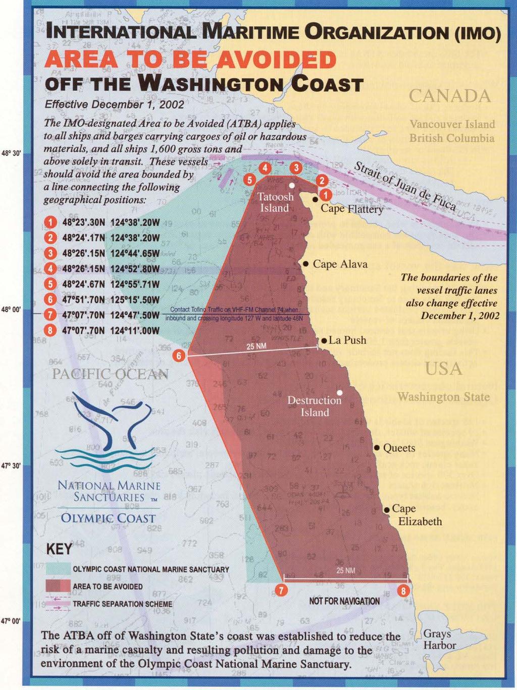
3 Table of Contents Introduction iii Quick Reference Guide 1-1 Section 2 Vessel Traffic Management 2-1 Subpart A Vessel Traffic Services 2-2 Subpart B Vessel Movement Reporting System (VMRS) 2-10 Subpart C Vessel Traffic Service Areas, Cooperative Vessel Traffic Service 2-14 Area, Vessel Traffic Service Special Areas, and Reporting Points Section 3 - Regulated Navigation Areas 3-1 Section 4 IMO Rule Vessel Speed & Wake Control 4-2 Anchorage Reservations 4-3 Section 5 VHF Radio Areas & Call-In Points 5-2 Ferry Crossing Routes 5-3 Commercial Salmon Management & Catch Reporting Areas 5-4 Canada/U.S. Cooperative Vessel Traffic Service (CVTS) 5-5 English Language 5-6 Message Markers 5-6 Puget Sound Harbor Safety Plan, Executive Statement 5-7 IMO Area To Be Avoided (ATBA) off the Washington Coast 5-8 International Tug of Opportunity of System 5-10
4 Notes
5 INTRODUCTION This manual is intended to provide the user with information necessary for participating in the Vessel Traffic Service Puget Sound (VTSPS). This manual is not intended to conflict with or modify the National Vessel Traffic Services Regulations in any respect, and any apparent conflict should be resolved in favor of the Regulations. This manual is not intended to replace or alter any federal regulations nor does it necessarily include all references made herein. It also contains supplementary text (In bold print and an alternate font) which is not part of the Regulations, but is intended to be explanatory, or helpful, in nature. This manual does meet the requirement set forth in 33 CFR Part 161.4, "Requirement to Carry the Rules". The Puget Sound area and the waters of the Pacific Northwest provide several fine harbors for commercial and public vessels. The area has historically supported a valuable fishery (both commercial and recreation) and a large, ever increasing, recreational fleet. The establishment of VTSPS is a major effort by the U. S. Coast Guard to ensure the continued safe use of these waters for its many diverse users. Our purpose is to facilitate the safe and efficient transit of vessel traffic to assist in the prevention of collisions or groundings that could cost lives, property damage, or subject the waters of this beautiful area to environmental harm. Additionally, by facilitating the safe and efficient flow of commerce, VTSPS serves as an intermodal partner in supporting the National Transportation System. Many regulations contained herein are applicable to all vessels, no matter the size, operating in the Vessel Traffic Service Puget Sound Area. While certain regulations are applicable only to vessels of certain length, tonnage, and/or engaged in certain specific activities, it is incumbent upon the operator of any vessel in this area to be familiar with the regulations for the particular type vessel being operated. The Ports and Waterways Safety Act, as amended, prescribes civil and criminal penalties for violation of the regulations. VTSPS is comprised of three major components: (1) A Vessel Movement Reporting System (VMRS); (2) A Traffic Separation Scheme (TSS); and (3) Surveillance systems including radar and closed circuit television. The VMRS is based upon a VHF-FM communications network maintained continuously by the Vessel Traffic Center (VTC) in Seattle. This network consists of 14 variable power sites. The location of these communication sites throughout the VTSPS area allows mariners to contact the VTC while normally only using low power on their radio. The VTC processes all information received and disseminates navigational safety information to those vessels asking for or requiring it. Much of the information processed by the VTC is collected from vessel reports, so mariners are cautioned that advisories based on vessel reports are only as accurate as the information given to the VTC from vessels in the VTS area. The TSS in the VTSPS area has been adopted by the International Maritime Organization (IMO) and is subject to the provisions of Rule 10 of the 1972 Collision Regulations. The
6 traffic lanes and separation zone that comprise the TSS are depicted on nautical charts. International Collision Regulations apply throughout the VTSPS area. The VTC receives radar signals from 12 strategically located radar sites throughout the VTSPS area. Radar provides approximately 2,900 square miles of coverage including the Strait of Juan de Fuca, Rosario Strait, Admiralty Inlet, and Puget Sound south to Commencement Bay. Additionally, close circuit TV provides coverage of various critical waterways. The VTC may not have first hand knowledge of all hazardous conditions that exist in the VTSPS area, so unreported hazards may confront the mariner at any time. Such hazards should be reported to the VTC so they may pass that information on to other mariners. Since 1979, the U.S. Coast Guard has worked cooperatively with the Canadian Coast Guard in managing vessel traffic in adjacent waters through the Cooperative Vessel Traffic Service (CVTS). Two Canadian Vessel Traffic Centers work hand in hand with Puget Sound Vessel Traffic Service. The area west of the Strait of Juan De Fuca is managed by Tofino Vessel Traffic (VHF-FM CH 74). North of the Strait of Juan De Fuca, through Haro Strait, to Vancouver Harbour, BC is managed by Victoria Vessel Traffic Service (VHF-FM CH 11). The three Vessel Traffic Centers communicate via a computer link and dedicated telephone lines to advise each other of vessels passing between their respective zones. We encourage all interested parties to visit the Vessel Traffic Center. Visiting hours are from 0800 to 1800 daily. Reservations are requested for large tour groups. We also encourage suggestions for improvements to this manual or to VTS operating procedures. Send suggestions, comments or requests for additional copies of this Users Manual to: Commanding Officer Vessel Traffic Service Puget Sound 1519 Alaskan Way South Seattle, WA Phones: (206) Automated phone directory (206) Vessel Traffic Center Facsimile: (206) USCG Home Page: VTS Puget Sound: VTSPSOps@pacnorwest.uscg.mil
7 Section 1 Quick Reference Guide What are the participation requirements? How do I communicate? What VHF-FM radio channel do I use? What information do I need to give Seattle traffic? What type of marine casualty or hazardous condition information must I provide to Seattle Traffic? What type of information will I receive from Seattle Traffic? How do I use the Traffic Separation scheme? What are the Rosario Strait and Guemes channel requirements?
8 Quick Reference Guide Section 1 What are the participation requirements for my vessel? In general, all waterborne craft are subject to: (a) 1972 Collision Regulations (72 COLGREGS); (b) VTS Measures (33 CFR ); (c) All other practices of safe navigation and prudent seamanship. This participation category includes vessels of every description, powered or not. The VTS Puget Sound Recreational Boater s Guide offers more detailed information. It is available through the resources listed in the Introduction section of this manual. For the VTS user, -Passive participation is required. This level of participation, as a minimum, consists of the continuous monitoring of the appropriate VHF-FM VTS frequency (either 5A, or 14, depending on location) in addition to Channel 13. This class of user shall also respond if hailed by the VTS, and adhere to sections pertaining to general VTS operating rules. VTS users are defined as: (a) Every power driven vessels of 20 meters (approximately 66 feet) or more in length, while navigating: (b) Every vessel of 100 gross tons or more carrying 1 or more passengers for hire, while navigating: (c) A dredge or floating plant engaged in or near a channel or fairway in operations likely to restrict or affect navigation of other vessels. For the VMRS (Vessel Movement Reporting System) user, All parts of the VTS regulations are applicable. VMRS vessels are defined as: (a) Every power-driven vessel of 40 meters (approximately 131 feet) or more in length, while navigating; (b) Every commercial towing vessel of 8 meters (approximately 26 feet) or more in length, while navigating; (c) Every vessel certificated to carry 50 or more passengers for hire, when engaged in trade. The significant difference in participation of the VTS user in comparison to the VMRS, is the absence of the reporting requirements under Section 2, Subpart B to this manual. This exclusion does not prohibit the VTS user from making these additional reports if deemed beneficial to the safe navigation of your vessel. The additional participation is advisable if your transit will include passage through Canadian waters, or Haro Strait. Canadian Traffic Services set full participation requirements beginning at 20 meters. If your transit information is first received by the VTS, it will then be passed on to the appropriate Canadian Traffic Service, by the VTS. See section 5 for more information. Am I required to have the regulations with me? Both VMRS users and VTS users must carry a copy of current VTS regulations on board the vessel. This manual fulfills the requirement to carry the rules.
9 How do I communicate with the VTS? Using the appropriate VTS frequency listen for a moment before keying the radio, and with the use of low power, address the VTS as Seattle Traffic followed by the name of your vessel. (a) Each VMRS user and VTS user must have a combination of radio equipment capable of operating from the navigational bridge, that simultaneously maintains a listening watch on Channel 13 ( Mhz), and the designated VTS frequency. (b) A single VHF/FM radio capable of scanning, or with "dual watch" capability, will not meet the requirement of two radios. (c) A VHF watch on Channel 16 is not required on vessels subject to the Vessel Bridge-to-Bridge Radio Telephone Act, during participation with the VTS while maintaining a watch on Channel 13, and the VTS frequency. (d) A person required to maintain a listening watch must be able to communicate in the English language. Use of Message Markers is recommended when necessary. (e) Any fixed or portable radiotelephone equipment capable of transmitting and receiving on the designated VHF frequency may be used. What is the appropriate VTS frequency, channel 5A, or 14? (All users) Use VHF-FM channel 14 ( Mhz) when south of a line drawn from Nodule Point to Bush Point, or south of a line drawn due east from Possession Point when entering or exiting Possession Sound. Channel 5A ( Mhz) is used north of these lines. For more information on frequency change lines, see the chartlet in Section 5. Channel 13 is used as Seattle Traffic's secondary frequency when 5A or 14 are temporarily unavailable. Within the Strait of Juan de Fuca, vessels are encouraged to make passing arrangements on Channel 5A to ensure good understanding of intent by all parties. What information do I need to give "Seattle Traffic," and when? (VMRS User required, VTS user optional) Provide an initial report - Sailing Plan (SP) Call "Seattle Traffic" at least l5 minutes, but not more than 45 minutes, before navigating in the VTS area. Upon initial call, provide your vessel s name, and the general location of your vessel to permit VTS operators to select the proper radio transmission site. After "Seattle Traffic" answers your radio call, provide the following information about your voyage: (a) Vessels name and type. (b) Position. (c) Destination and Estimated Time of Arrival (ETA). (d) Anticipated speed of advance. (e) Intended route. (f) Time and point of entry into the Seattle Traffic area. (g) Dangerous cargo on board, or, in your tow if applicable. Provide position information - Position Report (PR) You must report your vessels name and position:
10 (a) When you get underway or enter the VTS area. (b) When inbound in the Strait of Juan de Fuca at west longitude. (c) When directed by the VTS (Seattle Traffic). Provide updated information - Sailing Plan Deviation Report (DR) You must provide updated information: (a) When your ETA to a destination changes by more than 30 minutes. (b) If you intend to deviate from the TSS or a VTS issued measure. (c) If you intend to operate differently than previously reported. Provide destination information - Final Report (FR) Upon arrival at your destination, or when leaving the VTS area, you must provide: (a) Vessel name. (b) Position. (c) Your intention to check out of the system. Are there any reporting exemptions? (VMRS users) Due to the nature of their operation, unless otherwise directed, the following vessels are exempted from providing Position and Final Reports: (a) Vessels on a published schedule and route. Example: WSF Ferries. (b) Vessels operating within an area of a radius of three nautical miles or less. Example: A tug and barge maneuvering within a short distance. (c) Vessels escorting another vessel or assisting another vessel in maneuvering procedures. Example: Escort, or assist tugs. Vessels exercising their exemption must report to the VTS: (a) A sailing plan at least five minutes, but not more than 15 minutes before navigating within the VTS area. This generally includes a brief description of the operation. (b) Any changes to the stated sailing plan, or, if the ETA varies more than 15 minutes. (c) Additional reports as directed by the VTS. What type of marine casualty or hazardous condition information must I provide to the VTS? Call "Seattle Traffic" immediately if the following or knowledge of the following occur: (a) Grounding; (b) Collision with a fixed or floating object. (c) Striking of a bridge; (d) Loss of propulsion, steering or reduction in ability to safely navigate or maneuver; (e) Occurrence adversely affecting seaworthiness or causing property damage in excess of $25,000, (including fire, explosion, flooding, etc.); (f) Incident adversely affecting the environmental quality of a waterway; (g) Incident involving hazardous materials; (h) Loss of life, or injury requiring professional medical attention. What type of information will I receive from Seattle Traffic? Advisories on vessel traffic are normally given in the following sequence: (a) Description (b) Location (c) Direction of movement
11 (d) Speed (e) Route/Destination (f) Description of operation or supplementary information Seattle Traffic will not normally repeat departure information on Washington State Ferries. Participants are required to monitor the VTS channel and listen for Washington State Ferry departures. When visibility drops below 2 nautical miles, Seattle Traffic will pass Washington State Ferry transit information to all relevant participants. How do I use the TSS (traffic separation scheme)? The requirements for using the traffic lanes can be found in Rule 10 of the 1972 International Regulations for the Prevention of Collisions at Sea (1972 COLREGS). A copy of Rule 10 is included in this manual. These requirements apply to all vessels not just those participating in the VTS. What are the Rosario Strait and Guemes Channel requirements? If transiting Rosario Strait or Guemes Channel: (a) Towing vessels shall not impede the passage of a vessel of 40,000 dead weight tons or more. (b) A vessel of 100 meters or more in length will not be allowed to meet or overtake; or, cross or operate within 2000 yards of a vessel of 40,000 dead weight tons or more (except when crossing astern). (c) A vessel of 40,000 dead weight tons or more will not be allowed to meet or overtake; or, cross or operate within 2000 yards of a vessel of 100 meters or more in length (except when crossing astern). (d) Vessels of 40,000 dead weight tons or more require authorization from Seattle Traffic to enter or get underway in Rosario Strait and/or Guemes Channel. (e) A vessel requiring authorization shall provide at least 15 minutes notification prior to entering or getting underway within Rosario Strait or Guemes Channel. (f) Vessels experiencing maneuverability or navigational difficulties, or any other situation that may impair their safe transit, must report this to Seattle Traffic before entering or getting underway in either Rosario Strait or Guemes Channel. (g) Vessels required to fully participate with VTS (VMRS Users) must communicate on channel 13 to make safe passing arrangements before meeting, crossing or overtaking any other VMRS User. NOTE: Definitions of Guemes Channel / Rosario Strait geographic boundaries can be found in 33CFR Part (c). These areas are referred to as "VTS Special Areas." Exception: A partial deviation to the VTS Special Area regulations for Rosario Strait and Guemes Channel has been granted to allow all Washington State Ferries departing Ships Harbor, WA en-route to the San Juan Islands to meet vessels greater that 40,000 dead weight tons when their ultimate intention is to pass astern. May I depart from these rules for convenience? Deviations will be granted for navigational safety reasons only, and not for matters of convenience such as saving time. Deviations from regulations may be granted verbally for one time transits by "Seattle Traffic" or for extended periods by written authorization from the Commander (m), 13th Coast Guard District, 915 2nd Ave. Seattle, WA
12 NOTE: In emergency situations, specific verbal requests are not required, however, you must notify Seattle Traffic as soon as possible regarding the deviation. Does Seattle Traffic have the authority to direct the movement of my vessel? Yes: Seattle Traffic may issue measures or directions to enhance navigation and vessel safety and protect the marine environment by: (a) Designating temporary reporting points and procedures; (b) Imposing vessel operating requirements; (c) Establishing vessel traffic routing schemes; (d) During conditions of vessel congestion, restricted visibility, adverse weather, or other hazardous circumstances, Seattle Traffic may control, supervise, or otherwise manage traffic, specifying times of entry, movement, or departure, from, or within Seattle Traffic's area. The primary function of a VTS is to instill good order and predictability on a waterway. In no way will the VTS relieve the master of his or her responsibility to control vessel movement.
13 Section 2 VTS Regulations (excerpts from 33CFR) VESSEL TRAFFIC MANAGEMENT Subpart A Vessel Traffic Services General Rules Services, VTS Measures, and Operating Requirements Subpart B Vessel Movement Reporting System (VMRS) Subpart C Vessel Traffic Service Areas Cooperative Vessel Traffic Service Area Vessel Traffic Service Special Areas, and Reporting Points
14 Subpart A General Rules. (Reference 33 CFR Parts 160, 161) Commanding Officer, VTS definition from Ports and Waterways Safety Purpose and Intent. Vessel Traffic Management Definitions Applicability Requirement to carry the rules Deviations from the rules. Services, VTS measures, and operating requirements Services VTS measures Vessel operating requirements VTS Special Area operating requirements Purpose and Intent. (a) The purpose of this part is to promulgate regulations implementing and enforcing certain sections of the Ports and Waterways Safety Act (PWSA) setting up a national system of Vessel Traffic Services that will enhance navigation, vessel safety, and marine environmental protection, and promote safe vessel movement by reducing the potential for collisions, rammings, and groundings, and the loss of lives and property associated with these incidents within VTS areas established hereunder. (b) Vessel Traffic Services provide the mariner with information related to the safe navigation of a waterway. This information, coupled with the mariner's compliance with the provisions set forth in this part, enhances the safe routing of vessels through congested waterways or waterways of particular hazard. Under certain circumstances, a VTS may issue directions to control the movement of vessels in order to minimize the risk of collision between vessels, or damage to property or the environment. (c) The owner, operator, chartered, master, or person directing the movement of a vessel remains at all times responsible for the manner in which the vessel is operated and maneuvered, and is responsible for the safe navigation of the vessel under all circumstances. Compliance with these rules or with a direction of the VTS is at all times contingent upon the exigencies of safe navigation. (d) Nothing in this part is intended to relieve any vessel, owner, operator, charterer, master, or person directing the movement of a vessel from the consequences of any neglect to comply with this part or any other applicable law or regulation (e.g., the International Regulations for Prevention of Collisions at Sea, 1972 (72 COLREGS) or the Inland Navigation Rules) or of the neglect of any precaution which may be required by the ordinary practice of seamen, or by the special circumstances of the case Definitions. Commanding Officer, Vessel Traffic Services means the Coast Guard officer
15 designated by the Commandant to command a Vessel Traffic Service (VTS), or his designated representative, as described in part 161 of this chapter Definitions Hazardous Condition means any condition that may adversely affect (1) The safety of any vessel, bridge, structure, or shore area or (2) The environmental quality of any port, harbor, or navigable waterway of the United States. It may -- but need not --involve collision, allision, fire, explosion, grounding, leaking, damage, injury or illness of a person aboard, or manning shortage Definitions. For the purposes of this part: Cooperative Vessel Traffic Services (CVTS) means the system of vessel traffic management established and jointly operated by the United States and Canada within adjoining waters. In addition, CVTS facilitates traffic movement and anchorages, avoids jurisdictional disputes, and renders assistance in emergencies in adjoining United States and Canadian waters. Hazardous Vessel Operating Condition means any condition related to a vessel's ability to safely navigate or maneuver, and includes, but is not limited to: (1) The absence or malfunction of vessel operating equipment, such as propulsion machinery, steering gear, radar system, gyrocompass, depth sounding device, automatic radar plotting aid (ARPA), radiotelephone, Automatic Identification System equipment, navigational lighting, sound signaling devices or similar equipment. (2) Any condition on board the vessel likely to impair navigation, such as lack of current nautical charts and publications, personnel shortage, or similar condition. (3) Vessel characteristics that affect or restrict maneuverability, such as cargo arrangement, trim, loaded condition, underkeel clearance, speed, or similar characteristics. Precautionary Area means a routing measure comprising an area within defined limits where vessels must navigate with particular caution and within which the direction of traffic may be recommended. Towing Vessel means any commercial vessel engaged in towing another vessel astern, alongside, or by pushing ahead. Vessel Movement Reporting System (VMRS) is a system used to manage and track vessel movements within a VTS area. This is accomplished by a vessel providing information under established procedures as set forth in this part, or as directed by the VTS. Vessel Movement Reporting System (VMRS) User means a vessel, or an owner, operator, charterer, master, or person directing the movement of a vessel, that is required to participate in a VMRS within a VTS area. VMRS participation is required for:
16 (1) Every power-driven vessel of 40 meters (approximately 131 feet) or more in length, while navigating; (2) Every towing vessel of 8 meters (approximately 26 feet) or more in length, while navigating; or Every vessel certificated to carry 50 or more passengers for hire, when engaged in trade. Vessel length is measured from end to end over the deck, excluding sheer. Vessel Traffic Center (VTC) means the shore-based facility that operates the vessel traffic service for the Vessel Traffic Service area or sector within such an area. Vessel Traffic Services (VTS) means a service implemented by the United States Coast Guard designed to improve the safety and efficiency of vessel traffic and to protect the environment. The VTS has the capability to interact with marine traffic and respond to traffic situations developing in the VTS area. Vessel Traffic Service Area or VTS Area means the geographical area encompassing a specific VTS area of service. This area of service may be subdivided into sectors for the purpose of allocating responsibility to individual Vessel Traffic Centers or to identify different operating requirements. NOTE: Although regulatory jurisdiction is limited to the navigable waters of the United States, certain vessels will be encouraged or may be required, as a condition of port entry, to report beyond this area to facilitate traffic management within the VTS area. VTS Special Area means a waterway within a VTS area in which special operating requirements apply. VTS user means a vessel, or an owner, operator, charterer, master, or person directing the movement of a vessel, that is: (a) Subject to the Vessel Bridge-to-Bridge Radiotelephone Act; or (b) Required to participate in a VMRS within a VTS area (VMRS User). VTS User's Manual means the manual established and distributed by the VTS to provide the mariner with a description of the services offered and rules in force for that VTS. Additionally, the manual may include chartlets showing the area and sector boundaries, general navigational information about the area, and procedures, radio frequencies, reporting provisions and other information which may assist the mariner while in the VTS area Applicability. The provisions of this subpart shall apply to each VTS user and may also apply to any vessel while underway or at anchor on the navigable waters of the United States within a VTS area, to the extent the VTS considers necessary. VTS may require vessels involved in regattas or other marine events to comply with these provisions Requirement to carry the rules. Each VTS user shall carry on board and maintain for ready reference a copy of these rules.
17 NOTE: These rules are contained in the applicable U.S. Coast Pilot, the VTS User's Manual which may be obtained by contacting the appropriate VTS, and periodically published in the Local Notice to Mariners. The VTS User's Manual and the World VTS Guide, an International Maritime Organization (IMO) recognized publication, contain additional information which may assist the prudent mariner while in the appropriate VTS area Deviations from the rules. (a) Requests to deviate from any provision in this part, either for an extended period of time or if anticipated before the start of a transit, must be submitted in writing to the appropriate District Commander. Upon receipt of the written request, the District Commander may authorize a deviation if it is determined that such a deviation provides a level of safety equivalent to that provided by the required measure or is a maneuver considered necessary for safe navigation under the circumstances. An application for an authorized deviation must state the need and fully describe the proposed alternative to the required measure. (b) Requests to deviate from any provision in this part due to circumstances that develop during a transit or immediately preceding a transit, may be made verbally to the appropriate VTS Commanding Officer. Requests to deviate shall be made as far in advance as practicable. Upon receipt of the request, the VTS Commanding Officer may authorize a deviation if it is determined that, based on vessel handling characteristics, traffic density, radar contacts, environmental conditions and other relevant information, such a deviation provides a level of safety equivalent to that provided by the required measure or is a maneuver considered necessary for safe navigation under the circumstances. Services, VTS Measures, and Operating Requirements Services. To enhance navigation and vessel safety, and to protect the marine environment, a VTS may issue advisories, or respond to vessel requests for information, on reported conditions within the VTS area, such as: (a) Hazardous conditions or circumstances; (b) Vessel congestion; (c) Traffic density; (d) Environmental conditions; (e) Aids to navigation status; (f) Anticipated vessel encounters; (g) Another vessel's name, type, position, hazardous vessel operating conditions, if applicable, and intended navigation movements, as reported; (h) Temporary measures in effect; (i) A description of local harbor operations and conditions, such as ferry routes, dredging, and so forth; (j) Anchorage availability; or (k) Other information or special circumstances.
18 VTS measures. (a) A VTS may issue measures or directions to enhance navigation and vessel safety and to protect the marine environment, such as, but not limited to: (1)Designating temporary reporting points and procedures; (2)Imposing vessel operating requirements; or (3)Establishing vessel traffic routing schemes. (b) During conditions of vessel congestion, restricted visibility, adverse weather, or other hazardous circumstances, a VTS may control, supervise, or otherwise manage traffic, by specifying times of entry, movement, or departure to, from, or within a VTS area Vessel operating requirements. (a) Subject to the exigencies of safe navigation, a VTS user shall comply with all measures established or directions issued by a VTS. (1) If, in a specific circumstance, a VTS user is unable to safely comply with a measure or direction issued by the VTS, the VTS user may deviate only to the extent necessary to avoid endangering persons, property or the environment. The deviation shall be reported to the VTS as soon as is practicable. (b) When not exchanging communications, a VTS user must maintain a listening watch as required by 26.04(e) of this chapter on the VTS frequency designated in Table (b) (VTS Call Signs, Designated Frequencies, and Monitoring Areas). In addition, the VTS user must respond promptly when hailed and communicate in the English language. NOTE: As stated in 47 CFR (b), a VHF watch on Channel 16 ( MHz) is not required on vessels subject to the Vessel Bridge-to-Bridge Radiotelephone Act and participating in a Vessel Traffic Service (VTS) system when the watch is maintained on both the vessel bridge-to-bridge frequency and a designated VTS frequency. When anchored or moored to a buoy in the VTS area, the master, pilot, or person directing the movement of a vessel, is requested to insure that a radio telephone listening watch is maintained on the appropriate VTS frequency except when transmitting on that frequency. This radio listening watch may be maintained in a location other than the vessel s navigational bridge. (c) As soon as is practicable, a VTS user shall notify the VTS of any of the following: (1) A marine casualty as defined in 46 CFR ; (2) Involvement in the ramming of a fixed or floating object; (3) A pollution incident as defined in of this chapter; (4) A defect or discrepancy in an aid to navigation; (5) A hazardous condition as defined in of this chapter; (6) Improper operation of vessel equipment required by Part 164 of this chapter; (7) A situation involving hazardous materials for which a report is required by 49 CFR ; and (8) A hazardous vessel operating condition as defined in (9) Additionally, the master of a vessel is requested to report any hazardous conditions whenever observed unless they are known to have been previously reported.
19 Conditions of importance to the VTC and other participants include, but are not limited to the following: (a) Reduced visibility and other adverse weather conditions. (b) Concentrations of vessels. (c) Floating logs or other obstructions. (d) Any defect observed on another vessel that may affect safe navigation. Regattas occur often within the VTS area. The VTC is normally in contact with the regatta officials. The general position of the concentration of boats will be passed to affected users by the VTC. The State of Washington periodically opens fishing to licensed commercial fishermen. When this occurs, certain areas of Puget Sound may become heavily congested and highly susceptible to casualties. The Coast Guard may implement the provisions of 33CFR which establish special procedures for transiting these areas if a hazardous level of vessel congestion is deemed to exist. The text of 33 CFR is included in Section 3 of this manual (b) - U.S. and Canadian Vessel Traffic Service call signs, designated frequencies, and monitoring areas. NOTE: This section reflects the requirements for operating in the Seattle, Tofino, Victoria, and Vancouver areas only. Seattle Traffic MHz (Ch. 14) The navigable waters of Puget Sound, Hood Canal, and adjacent waters south of a line connecting Nodule Point and Bush Point in Admiralty Inlet, and south of a line drawn due east from the southernmost tip of Possession Point on Whidbey Island to the shoreline. Seattle Traffic MHz (Ch. 5A) The navigable waters of the Strait of Juan de Fuca east of W., excluding the waters in the central portion of the Strait of Juan de Fuca north and east of Race Rocks; the navigable waters of the Strait of Georgia east of W.; the San Juan Island Archipelago, Rosario Strait, Bellingham Bay; Admiralty Inlet north of a line connecting Nodule Point and Bush Point and all waters east of Whidbey Island north of a line drawn due east from the southernmost tip of Possession Point on Whidbey Island to the shoreline. Tofino Traffic MHz (Ch. 74) The waters west of W. within 50 nautical miles of the coast of Vancouver Island including the waters north of 48N., and east of 127W. Victoria Traffic MHz (Ch.11)
20 The navigable waters of the Strait of Georgia to Merry & Ballenas Island, excluding the areas of responsibility of Vancouver Traffic, the navigable waters of the central Strait of Juan de Fuca north and east of Race Rocks, including the Gulf Island Archipelago, Boundary Pass and Haro Strait. Vancouver Traffic MHz (Ch.12) The navigable waters north of Iona Jetty (including Howe Sound) extending westward to a line directly south of Cape Roger Curtis, Bowen Island. The navigable waters east of Cape Roger Curtis including Burrard Inlet and Indian Arm. Alternate usage, and enforcement: (1) In the event of a communication failure either by the vessel traffic center, vessel, or, radio congestion on a designated VTS frequency, communications may be established on an alternate VTS frequency. The bridge-to-bridge navigational frequency, MHz (Ch. 13), is monitored in each VTS area; and it may be used as an alternate frequency, however, only to the extent that doing so provides a level of safety beyond that provided by other means. (2) Designated frequency monitoring is required within U.S. navigable waters. In areas which are outside theses waters, designated frequency monitoring is voluntary but encouraged. (3) Seattle Traffic may direct a vessel to monitor the other primary VTS frequency , or, MHz (5A, 14) depending on traffic density, weather conditions, or other safety factors in lieu of the normal VTS frequency for the area. A vessel is not required to monitor both VTS frequencies if directed to an alternate frequency. Please note that Channel 5A is a U.S. simplex channel and not to be confused with 5 International. Radios equipped with an INT/US switch should enable it to the US position. (4) A portion of Tofino s monitoring area extends beyond the defined CVTS area. Designated frequency monitoring is voluntary in these portions outside of VTS jurisdiction, however, prospective VTS Users are encouraged to monitor the designated frequency. A Cooperative Vessel Traffic Service was established by the United States and Canada within adjoining waters. The appropriate vessel traffic center administers the rules issued by both nations, however enforces only their respective VTS rules, and monitoring requirements. Example: While transiting Canadian waters in the Strait of Juan de Fuca, your vessel will be required to follow Seattle Traffic s rules of participation, and monitor the appropriate Seattle Traffic frequency VTS Special Area Operating Requirements. The following operating requirements apply within a VTS Special Area: (a) A VTS user shall, if towing astern, do so with as short a hawser as safety and good seamanship permits. (b) A VMRS user shall: (1) Not enter or get underway in the area without prior approval of the VTS;
21 (2) Not enter a VTS Special Area if a hazardous vessel operating condition or circumstance exists; (3) Not meet, cross, or overtake any other VMRS user in the area without prior approval of the VTS; and (4) Before meeting, crossing, or overtaking any other VMRS user in the area, communicate on the designated vessel bridge-to-bridge radiotelephone frequency, intended navigation movements, and any other information necessary in order to make safe passing arrangements. This requirement does not relieve a vessel of any duty prescribed by the International Regulations for Prevention of Collisions at Sea, 1972 (72 COLREGS) or the Inland Navigation Rules (b)(i) and (b)(3) are amended by Subpart C, Vessel Traffic Service Puget Sound and the Cooperative Vessel Traffic Service for the Juan De Fuca Region. See Sections (d)(2) and (d)(3) for applicability.
22 Subpart B Purpose and intent. (a) A Vessel Movement Reporting System (VMRS) is a system used to manage and track vessel movements within a VTS area. This is accomplished by requiring that vessels provide information under established procedures as set forth in this part, or as directed by the VTS. (b) To avoid imposing an undue reporting burden or unduly congesting radiotelephone frequencies, reports shall be limited to information which is essential to achieve the objectives of the VMRS. These reports are consolidated into four reports (sailing plan, position, sailing plan deviation and final) Applicability The provisions of this subpart shall apply to the following VMRS Users: (a) Every power-driven vessel of 40 meters (approximately 131 feet) or more in length, while navigating; (b) Every towing vessel of 8 meters (approximately 26 feet) or more in length, while navigating; or (c) Every vessel certificated to carry 50 or more passengers for hire, when engaged in trade Definitions. As used in this subpart: Published means available in a widely-distributed and publicly available medium (e.g., VTS User's Manual, ferry schedule, Notice to Mariners) Reporting requirements. (a) A VTS may: Direct a vessel to provide any of the information set forth in Table (a) (IMO Standard Ship Reporting System);
23 TABLE (a) THE IMO STANDARD SHIP REPORTING SYSTEM A ALPHA Ship. Name, call sign or ship station identity, and flag. B BRAVO Dates and time of event. A 6 digit group giving day of month (first two digits) hours and minutes (last four digits). If other than UTC state time zone used. C CHARLIE Position. A 4 digit group giving latitude in degrees and minutes suffixed with N (north) or S (south) and a 5 digit group giving longitude in degrees and minutes suffixed with E (east) or W (west); or. D DELTA Position. True bearing (first 3 digits) and distance (state distance) in nautical miles from a clearly identified landmark (state landmark). E ECHO True course. A 3 digit group. F FOXTROT Speed in knots and tenths of knots. A 3 digit group. G GOLF Port of Departure. Name of last port of call. H HOTEL Date, time and point of entry system. Entry time expressed as in (B) and into the entry position expressed as in (C) or (D). I INDIA Destination and expected time of arrival. Name of port and date time group expressed as in (B). J JULIET Pilot. State whether a deep sea or local pilot is onboard. K KILO Date, time and point of exit from system. Exit time expressed as in (B) and exit position expressed as in (C) or (D). L LIMA Route information. Intended track. M MIKE Radio. State in full names of communications stations/frequencies guarded N NOVEMBER Time of next report. Date time group expressed as in (B). O OSCAR Maximum present static draught in meters. 4 digit group giving meters and centimeters. P PAPA Cargo on board. Cargo and brief details of any dangerous cargoes as well as harmful substances and gases that could endanger persons or the environment. Q QUEBEC Defects, damage, deficiencies or limitations. Brief detail of defects, damage, deficiencies or other limitations R ROMEO Description of pollution or dangerous goods lost. Brief details of type of pollution (oil, chemicals, etc) or dangerous goods lost overboard; position expressed as in (C) or (D). S SIERRA Weather conditions. Brief details of weather and sea conditions prevailing. T TANGO Ship's representative and/or owner. Details of name and particulars of ship's representative and/or owner for provision of information. U UNIFORM Ship size and type. Details of length, breadth, tonnage, and type, etc., as required. V VICTOR Medical personnel. Doctor, physician's assistant, nurse, no medic. W WHISKEY Total number of persons on board. State number. X XRAY Miscellaneous. Any other information as appropriate, [i.e. a detailed description of a planned operation, which may include: its duration, effective area; any restrictions to navigation; notification procedures for approaching vessels; in addition, for a towing operation: configuration, length of the tow, available horsepower, etc; for a dredge or floating plant: configuration of pipeline, mooring configuration, number of assist vessels, etc.]. (2) Establish other means of reporting for those vessels unable to report on the designated frequency; or (3) Require reports from a vessel in sufficient time to allow advance vessel traffic planning. (b) All reports required by this part shall be made as soon as is practicable on the
24 frequency designated in Table (b) (VTS Call Signs, Designated Frequencies, and Monitoring Areas). (c) When not exchanging communications, a VMRS user must maintain a listening watch as described in 26.04(e) of this chapter on the frequency designated in Table (b) (VTS Call Signs, Designated Frequencies, and Monitoring Areas). In addition, the VMRS user must respond promptly when hailed and communicate in the English language. NOTE: As stated in 47 CFR (b), a VHF watch on Channel 16 ( MHz) is not required on vessels subject to the Vessel Bridge-to-Bridge Radiotelephone Act and participating in a Vessel Traffic Service (VTS) system when the watch is maintained on both the vessel bridge-to-bridge frequency and a designated VTS frequency. (d) When reports required by this part include time information, such information shall be given using the local time zone in effect and the 24-hour military clock system Sailing Plan (SP). Unless otherwise stated, at least 15 minutes before navigating a VTS area, a vessel must report the: (a) Vessel name and type; (b) Position; (c) Destination and ETA; (d) Intended route; (e) Time and point of entry; and (f) Dangerous cargo on board or in its tow, as defined in of this chapter, and other required information as set out in and of this chapter, if applicable. In the VTS area, a vessel is requested to report their anticipated speed of advance following destination and ETA Position Report (PR). A vessel must report their name and position: (a) Upon entry into a VTS area; (b) At designated reporting points as set forth in subpart C; or, (c) When directed by the VTS. NOTE: Notice of temporary reporting points, if established, may be published via Local Notices to Mariners, general broadcast or the VTS User's Manual Sailing Plan Deviation Report (DR). A vessel must report: (a) When its ETA to a destination varies significantly (by more than 30 minutes) from a previously reported ETA; (b) Any intention to deviate from a VTS issued measure or vessel traffic routing system; or
25 (c) Any significant deviation from previously reported information Final Report (FR). A vessel must report its name and position: (a) On arrival at its destination; or, (b) When leaving a VTS area Reporting Exemptions. (a) Unless otherwise directed, the following vessels are exempted from providing Position and Final Reports due to the nature of their operation: (1) Vessels on a published schedule and route; (2) Vessels operating within an area of a radius of three nautical miles or less; or (3) Vessels escorting another vessel or assisting another vessel in maneuvering procedures. (b) A vessel described in paragraph (a) of this section must: (1) Provide a Sailing Plan at least 5 minutes but not more than 15 minutes before navigating within the VTS area; and (2) If it departs from its promulgated schedule by more than 15 minutes or changes its limited operating area, make the established VMRS reports, or report as directed.
26 Subpart C NOTE: all geographic coordinates contained in part 161 (latitude and longitude) are expressed in North American Datum of 1983 (NAD 83) Vessel Traffic Service Puget Sound and the Cooperative Vessel Traffic Service for the Juan de Fuca Region. (a) The Vessel Traffic Service Puget Sound area consists of the navigable waters of the United States bounded by a line drawn from the Washington State coastline at 48-23'08"N., '37"W. on Cape Flattery to the Cape Flattery Light at 48-23'30"N., '12"W. on Tatoosh Island, due west to the U.S. Territorial Sea Boundary; thence northward along the U.S. Territorial Sea Boundary to its intersection with the U.S./Canada International Boundary; thence east along the U.S./Canada International Boundary through the waters known as the Strait of Juan de Fuca, Haro Strait, Boundary Pass, and the Strait of Georgia to the Washington State coastline at 49-00'06", '18"W. (International Boundary Range C Rear Light). This area includes: Puget Sound, Hood Canal, Possession Sound, the San Juan Island Archipelago, Rosario Strait, Guemes Channel, Bellingham Bay, the U.S. waters of the Strait of Juan de Fuca and the Strait of Georgia, and all waters adjacent to the above. (b) Vessel Traffic Service Puget Sound participates in a U.S./Canadian Cooperative Vessel Traffic Service (CVTS) to jointly manage vessel traffic in the Juan de Fuca Region. The CVTS for the Juan de Fuca Region consists of all waters of the Strait of Juan de Fuca and its offshore approaches, southern Georgia Strait, the Gulf and San Juan Archipelagos, Rosario Strait, Boundary Pass and Haro Strait, bounded on the northwest by 48-35'45"N.; and on the southwest by 48-23'30"N.; and on the west by the rhumb line joining 48-35'45"N., '30"W. with 48-23'30"N., '37"W.; and on the northeast in the Strait of Georgia, by a line drawn along 49-N. from Vancouver Island to Semiahmoo Bay; and on the southeast, by a line drawn from McCurdy Point on the Quimper Peninsula to Point Partridge on Whidbey Island. Canadian and United States Vessel Traffic Centers (Tofino, B.C., Canada, Vancouver, BC, Canada and Seattle, WA) manage traffic within the CVTS area irrespective of the International Boundary. VTS Special Areas. (1) The Rosario Strait VTS Special Area consists of those waters bounded to the south by the center of Precautionary Area "RB" (a circular area of 2,500 yards radius centered at 48-26'24" N., '12"W.), and to the north by the center of Precautionary Area "C" (a circular area of 2,500 yards radius centered at 48-40'34"N., '44"W.; Lighted Buoy "C"); and NOTE: The center of precautionary area "RB" is not marked by a buoy. All precautionary areas are depicted on National Oceanic and Atmospheric Administration (NOAA) nautical charts. (2) The Guemes Channel VTS Special Area consists of those waters bounded to the west by Shannon Point on Fidalgo Island and to the east by Southeast Point on Guemes Island.
27 Additional VTS Special Area Operating Requirements. The following additional requirements are applicable in the Rosario Strait and Guemes Channel VTS Special Areas: (1) A vessel engaged in towing shall not impede the passage of a vessel of 40,000 dead weight tons or more. (2) A vessel of less than 40,000 deadweight tons is exempt from the provision set forth in (b)(1) of this part. (3) A vessel of less than 100 meters in length is exempt from the provisions set forth in (b)(3) of this part. Approval will not be granted for: (i) A vessel of 100 meters or more in length to meet or overtake; or cross or operate within 2,000 yards (except when crossing astern) of a vessel of 40,000 dead weight tons or more; or (ii) A vessel of 40,000 dead weight tons or more; to meet or overtake; or cross or operate within 2,000 yards (except when crossing astern) of a vessel of 100 meters or more in length. (4) Reporting Point. Inbound vessels (VMRS Users) in the Strait of Juan de Fuca upon crossing 124-W.
28 Section 3 Regulated Navigation Areas (Excerpts from 33 CFR Part 165) Subpart F Specific Regulated Navigation Areas and Limited Access Areas
29 PART 165 Regulated Navigation Areas and Limited Access Areas. Subpart F Specific Regulated Navigation Areas and Limited Access Areas. THIRTEENTH COAST GUARD DISTRICT Puget Sound, and adjacent Waters in Northwestern Washington - Regulated Navigation Area. The following is a regulated navigation area - All of the following northwestern Washington waters under the jurisdiction of the Captain of the Port, Puget Sound: Puget Sound, Hood Canal, Possession Sound, Elliott Bay, Commencement Bay, the San Juan Archipelago, Rosario Strait, Guemes Channel, Bellingham Bay, U.S. waters of the Strait of Juan de Fuca, Haro Strait, Boundary Pass, and Georgia Strait, and all lesser bays and harbors adjacent to the above. (a) Definitions as used in this section: (1) Vessels engaged in fishing are as identified in the definition found in Rule 3 of the International Regulations for Prevention of Collisions at Sea, 1972, (72 COLREGS), found in Appendix A, Part 81 of this chapter. (2) Hazardous levels of vessel traffic congestion are as defined at the time by Vessel Traffic Service Puget Sound. Hazardous levels of vessel traffic congestion generally will occur when vessels engaged in fishing or other operations restrict the ability of vessels following the TSS to safely navigate within the TSS. Vessel Traffic Service Puget Sound will broadcast the determination on the designated VTSPS frequency. (b) Nothing in this section shall be construed as relieving any party from their responsibility comply with applicable rules set forth in the 72 COLREGS. (c) General Regulations: The provisions of this paragraph apply at all times (1) Vessels engaged in fishing or other operations - that are distinct from vessels following a Traffic Separation Scheme (TSS) or a connecting precautionary area east of New Dungeness and which are not required by the Bridge to Bridge Radiotelephone Regulations to maintain a listening watch, are highly encouraged to maintain a listening watch on the Vessel Traffic Service Puget Sound (VTSPS) VHF-FM radio frequency for the area in which the vessel is operating. A safe alternative to the radio listening watch is to stay clear of the TSS and connecting precautionary area. (2) Vessels engaged in gillnet fishing at any time between sunset and sunrise in any of the waters defining the regulated navigation area of this section shall, in addition to the navigation lights and shapes required by Part 81 of this title (72 COLREGS), display at the end of the net most distant from the vessel an all-round 32-point) white light visible for a minimum of two nautical miles and displayed from at least three feet above the surface of the water (3) Vessels engaged in fishing, including gillnet and purse seine fishing, are prohibited in the following Prohibited Fishing Area: The Hood Canal Bridge, to include the waters within a one-half mile radius of the center of the main ship channel draw span during the immediate approach and transit of the draw by public vessels of the United
30 States. (4) East of New Dungeness, vessels engaged in fishing in a traffic lane or connecting precautionary area shall tend nets or other gear placed in the water so as to facilitate the movement of the vessel or gear from the traffic lane or precautionary area upon the approach of a vessel following the TSS. (d) Congested Regulations: The provisions under paragraph (d) apply only when imposed in specific locations by Vessel Traffic Service Puget Sound. They are intended to enhance vessel traffic safety during periods and in locations where hazardous levels of vessel traffic congestion are deemed to exist by Vessel Traffic Service Puget Sound. Operations potentially creating vessel traffic congestion include, but are not limited to, vessels engaged in fishing, including gillnet and purse seine, recreational fishing derbies, regattas, or permitted marine events. (1) Vessels engaged in fishing or other operations that are distinct from vessels following a Traffic Separation Scheme (TSS) or a connecting precautionary area east of New Dungeness, may not remain in, nor their gear remain in, a traffic lane or, a connecting precautionary area east of New Dungeness when a vessel following a TSS approaches. Such vessels not following a TSS or a connecting precautionary area shall draw in their gear, maneuver, or otherwise clear these areas so that their action is complete at least fifteen minutes before the arrival of a vessel following the TSS. Vessels which are required by paragraph (d)(1) to remain clear of a connecting precautionary area east of New Dungeness or a traffic lane must also remain clear of the adjacent separation zone when in a TSS east of New Dungeness. (2) A vessel following the TSS may not exceed a speed of 11 knots through the water. (3) Vessels engaged in fishing, including gillnet and purse seine fishing, are prohibited in the following Prohibited Fishing Area: Edmonds/Kingston ferry crossing lanes, to include the waters within one-quarter nautical mile on either side of a straight line connecting the Edmonds and Kingston ferry landings during the hours that the ferry is operating (e) Authorization to deviate from this section. (1) Commander, Thirteenth Coast Guard District may, upon written request, issue an authorization to deviate from this section if the proposed deviation provides a level of safety equivalent to or beyond that provided by the required procedure. An application for authorization must state the need for the deviation and describe the proposed alternative operation. (2) VTSPS may, upon verbal request, authorize a deviation from this section for a voyage, or part of a voyage, if the proposed deviation provides a level of safety equivalent to or beyond that provided by the required procedure. The deviation request must be made well in advance to allow the requesting vessel and the Vessel Traffic Center (VTC) sufficient time to assess the safety of the proposed deviation. Discussions between the requesting vessel and the VTC should include, but are not limited to, information on vessel handling characteristics, traffic density, radar contacts, and environmental conditions. (3) In an emergency, the master, pilot, or person directing the movement of the vessel following the TSS may deviate from this section to the extent necessary to avoid endangering persons, property, or the environment, and shall report the deviation to the VTC as soon as possible.
31 Puget Sound and adjacent waters, WA-regulated navigation area. Section will apply at all times. (a) The following is a regulated navigation area: the waters of the United States east of a line extending from Discovery Island Light to New Dungeness Light and all points in the Puget Sound area north and south of these lights. (b) Regulations. (1) Tank vessel navigation restrictions: Tank vessels larger than 125,000 deadweight tons bound for a port or place in the United States may not operate in the regulated navigation area. (2) Commander, Thirteenth Coast Guard District may, upon written request, issue and authorization to deviate from paragraph (b)(1) of this section if it is determined that such deviation provides an adequate level of safety. Any application for authorization must state the need and fully describe the proposed procedure. (c) Precautionary Area Regulations. (1) A vessel in a precautionary area which is depicted on National Oceanic and Atmospheric Administration (NOAA) nautical charts, except precautionary area "RB" (a circular area of 2,500 yards radius centered at 48-26'24"N., '12"W.), must keep the center of the precautionary area to port. NOTE: The center of precautionary area "RB" is not marked by a buoy. Section (c)(1) is intended to apply to vessels following, joining or leaving a Traffic Separation Scheme, and does not apply to vessels crossing the Traffic Separation Scheme through a connecting precautionary area. (2) The Vessel Traffic Service Puget Sound (VTSPS) may, upon verbal request, authorize a onetime deviation from paragraph (c)(1) of this section for a voyage, or part of a voyage, if the proposed deviation provides a level of safety equivalent to or beyond that provided by the required procedure. The deviation request must be made well in advance to allow the requesting vessel and the Vessel Traffic Center (VTC) sufficient time to assess the safety of the proposed deviation. Discussions between the requesting vessel and the VTC should include, but are not limited to, information on the vessel handling characteristics, traffic density, radar contacts, and environmental conditions. In an emergency, the master, pilot, or person directing the movement of the vessel may deviate from paragraph (c)(1) of this section to the extent necessary to avoid endangering persons, property, or the environment, and shall report the deviation to the VTC as soon as possible.
32 Section 4 IMO Rule 10 Speed and Wake Control Anchorage Reservations
33 IMO Rule 10 (International) Traffic Separation Schemes (a) This rule applies to traffic separation schemes adopted by the organization and does not relieve any vessel of her obligation under any other rule. (b) A vessel using a traffic separation scheme shall: (i) proceed in the appropriate traffic lane in the general direction of traffic flow for that lane; (ii) so far as practicable keep clear of a traffic separation line or separation zone; (iii) normally join or leave a traffic lane at the termination of the lane, but when joining or leaving from either side shall do so at as small an angle to the general direction of traffic flow as practicable. (c) a vessel shall, so far as practicable, avoid crossing traffic lanes but if obliged to do so shall cross on a heading as nearly as practicable at right angles to the general direction of traffic flow. (d) (i) A vessel shall not use an inshore traffic zone when she can safely use the appropriate traffic lane within the adjacent traffic separation scheme. However, vessels of less than 20 meters in length, sailing vessels and vessels engaged in fishing may use the inshore traffic zone. (ii) Notwithstanding subparagraph (d)(i), a vessel may use an inshore traffic zone when en route to or from a port, offshore installation or structure, pilot station or any other place situated within the inshore traffic zone, or to avoid immediate danger. (e) A vessel other than a crossing vessel or a vessel joining or leaving a lane shall not normally enter a separation zone or cross a separation line except: (i) in cases of emergency to avoid immediate danger; (ii) to engage in fishing within a separation zone. (f) A vessel navigating in areas near the terminations of traffic separation schemes shall do so with particular caution. (g) A vessel shall so far as practicable avoid anchoring in a traffic scheme or in areas near its terminations. (h) A vessel not using a traffic separation scheme shall avoid it by as wide a margin as is practicable. (i) A vessel engaged in fishing shall not impede the passage of any vessel following a traffic lane. (j) A vessel of less than 20 meters in length or a sailing vessel shall not impede the safe passage of a power-driven vessel following a traffic lane. Note: Shall not impede means a vessel MUST NOT navigate in such a way as to risk the development of a collision with another vessel (i.e. when a power driven vessel following a TSS is forced to make an unusual or dangerous maneuver in order to avoid one of the vessels listed above, then the vessel following the TSS has been impeded). (k) A vessel restricted in her ability to maneuver when engaged in an operation for the
34 maintenance of safety of navigation in a traffic separation scheme is exempted from complying with this rule to the extent necessary to carry out the operation. (l) A vessel restricted in her ability to maneuver when engaged in an operation for the laying, servicing or picking up of a submarine cable, within a traffic separation scheme, is exempted from complying with this rule to the extent necessary to carry out the operation. Vessel Speed and Wake Control 46 USC 2302 Penalties for negligent operations (a) A person operating a vessel in a negligent manner that endangers the life, limb or property of a person is liable to the United States Government for a civil penalty of not more that $1, Each vessel operator is responsible for operating their vessel at a safe speed, especially in reduced visibility, and for the wake created by their vessel. When a tide exceeds a stage of 11.0 feet at Seattle, there is an increased risk of vessel wakes endangering persons and/or property along the shoreline within the VTS Area. All vessels operating within the VTS Area should proceed at a speed that will minimize the risk of wake damage while maintaining the ability to maneuver safely. The VTS will begin tidal advisory broadcasts 30 minutes before the tide is predicted to exceed 11.0 feet in Seattle. This advisory will be re-broadcast every 30 minutes until the tidal state has subsided. Anchorage Reservations VTSPS manages the anchorages in Puget Sound and adjacent areas for the Captain of the Port. For safety reasons, each anchorage has a restricted number of anchorage spaces available, and are normally reserved on a first come, first served basis. To allow a more efficient and fair allocation of available space we ask that: 1. Reservations be made as far in advance of arrivals as possible. 2. Revisions of ETA s and ETD s be made as they become known. Reservations are only valid for the time span requested. A vessel staying past the ETD may be subject to movement orders to make room for an inbound vessel with a reservation. Anchorage reservations will not be accepted in high usage areas, such as Elliott Bay or Port Angeles, if there is a possibility of delay due to uncertain orders. With these considerations, the occasions of a vessel being denied anchorage or being ordered to depart to make room for another vessel should be infrequent.
35
36 Section 5 VHF Radio Areas & Call-In Points Ferry Crossing Routes Commercial Salmon Management & Catch Reporting Areas CANADA/U.S. Cooperative Vessel Traffic Service (CVTS) English Language Message Markers Puget Sound Harbor Safety Plan IMO Area To Be Avoided off the Washington Coast International Tug of Opportunity System

37 VHF Radio Areas and Call-In Points.

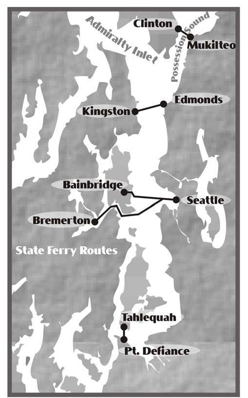
38 Ferry Crossing Routes

39 Commercial Salmon Management and Catch Reporting Areas
 General Information: Details and regulations concerning the Canadian/United States Cooperative Vessel Traffic Services (CVTS) are contained in Canadian")
40 CANADA/U.S. Cooperative Vessel Traffic Service (CVTS) General Information: Details and regulations concerning the Canadian/United States Cooperative Vessel Traffic Services (CVTS) are contained in Canadian Notice to Mariners, the U.S. Code of Federal Regulations, and in many nautical publications. For more information about the CVTS, contact In Canada In the United States Superintendent Commander (m) Marine Communications and Thirteenth Coast Guard District Traffic Services Jackson Federal Building Burrard Street, 915 Second Avenue Vancouver, B.C. V6B 4N6 Seattle, WA Canada U.S.A. Telephone: (604) Telephone: (206) Facsimile: (604) Facsimile: (206)
41 General information (continued) Participation with Tofino, Seattle and Victoria Traffic is mandatory within Canadian and U.S. territorial waters. The services, however, are available considerably further offshore, typically about 60 nautical miles. When inbound and crossing longitude 127 W, latitude 48 N, or within 50 NM of Vancouver Island, all vessels 20 meters or greater, including tugs and tows, contact Tofino Traffic on VHF Channel 74. Once under Tofino Traffic management, vessels will receive instructions on when to switch to new frequencies at Seattle Traffic (Channel 5A) and Victoria Traffic (Channel 11) zone boundaries. Though participation seaward of Canadian and U.S. territorial waters is not required, vessels are strongly encouraged to participate. All vessels over 300 GRT inbound to Canadian and US West Coast ports must file a 96 and 24 hour offshore advanced report as a condition of entry. Vessels are also encouraged to participate in order to receive the full benefit of the available Vessel Traffic Services. These benefits include traffic updates, warnings of vessel congestion or other hazardous conditions, and many other forms of transit assistance. English Language: All communications with Tofino, Seattle or Victoria Traffic must be made in clear, unbroken English. At least one person capable of conducting two-way radio communication using the English language must be present on the bridge at all times within the CVTS area. Message Markers: When language problems arise, the following message markers may precede communications: Questions Answer Request Information Intention Warning Advice Instruction Clearance request for information. the reply to a previous question. a request for action from others with respect to the ship. observed facts. notice of immediate planned navigational actions. information about dangers. a recommendation to correct a hazardous condition. a lawful order an authorization to proceed subject to conditions Rev. 3/03 (Previous editions obsolete)
42 Puget Sound Harbor Safety Plan The Puget Sound Harbor Safety Committee (PSHSC) is a duly constituted body of public and private stakeholders who share common interests in the safe, efficient, and environmentally sound use of Puget Sound and adjacent waters. As such, PSHSC takes responsibility for capturing existing and developing new standards and protocols that address those environmental and operational elements of maritime operations that are unique to Puget Sound. These standards and protocols are developed by local experts and are intended to increase safety. The standards and protocols included in the Puget Sound Harbor Safety Plan complement and supplement existing and future federal, state and local law. It is not intended to supplant or otherwise conflict with federal, state or local regulations developed under legal authorities, nor is the Puget Sound Harbor Safety Plan intended to replace the good judgment of a ship s master in the safe operation of his/her vessel. Chapters 1-7 of the plan are informative in nature, and provide important safety info for professional mariners transiting Puget Sound. Chapters 8-16 are Standards of Care developed by the Harbor Safety Committee that formalize and document good marine practice. The Harbor Safety Committee welcomes additional input and participation to improve the plan and increase the region's safety. The Puget Sound Harbor Safety Plan can be obtained by going to the Marine Exchange or the National HSC websites at:
43
44
45 INTERNATIONAL TUG OF OPPORTUNITY SYSTEM The International Tug of Opportunity System (ITOS) is a unique Northwest approach to facilitate emergency resource assistance to disabled vessels in the entrance areas to Washington State and Southern British Columbia waters, using tugs, which routinely transit these waters. Any vessels needing assistance in the entrance waters, including the Olympic Coast National Marine Sanctuary and through the Strait of Juan de Fuca, can access the tug resources identified by the ITOS. Tugs are outfitted with transponders that transmit their Differential Global Positioning System (DGPS) locations to the Marine Exchange of Puget Sound and Vessel Traffic Centers. The reported DGPS location is visible on an electronic chart computer screen coupled with a complete database of tug particulars. Vessel masters will contact the Marine Exchange of Puget Sound on VHF Channel 20 (International) to have all available tugs identified for them when assistance is necessary. If unable to contact the Marine Exchange, or during an actual emergency, contact Vessel Traffic Services as per the table in 33 CFR (b) (page 2-8 of this manual). Upon request the Vessel Traffic Services or Marine Exchange can provide the vessel master with tug location, course, speed, horsepower, bollard pull, etc. The information is essential to the vessel master, and response authorities in determining appropriate action to take when considering vessel location, type of assistance needed, vessel drift, weather, etc. Depending on the situation, the response authorities may dispatch assistance or coordinate response actions with the involved parties. However, primary responsibility to arrange for assistance remains with the vessel


46 VESSEL TRAFFIC SERVICE PUGET SOUND OUR PURPOSE: MISSION STATEMENT To enhance navigation, vessel safety, and marine environmental protection, and promote safe vessel movement by reducing the potential for collisions, rammings, and groundings, and the loss of lives. WE WILL: Enhance the good order and predictability of vessel traffic by providing clear, concise, accurate, meaningful, and timely advisories to mariners in our area of responsibility. Provide our personnel with a safe working and learning environment as well as humane, caring and equitable treatment to enhance command unity and morale. Be responsive to customer needs and dedicated to safeguarding our waterways, improving through education of all user groups and enhancing navigation safety throughout our area of responsibility. Provide the necessary initial/recurrent training, equipment, and guidance to our watchstanders to meet their personal and professional needs. Provide constructive feedback focused on continuously improving processes and our service. Manage vessel traffic by exercising the minimal amount of direct control necessary consistent with ensuring the safety of our waterways. Maintain intra-service, inter-governmental and maritime community liaisons to accomplish mission/unit goals and to assist these agencies in the performance of their missions.
Delaware River Vessel Reporting System Mariners Advisory Committee For
 Delaware River Vessel Reporting System Mariners Advisory Committee For the Bay and River Delaware The Mariner's Advisory Committee is comprised of Master Mariners, River Pilots, and concerns itself with
VESSEL TRAFFIC SERVICE HOUSTON/GALVESTON
 VESSEL TRAFFIC SERVICE HOUSTON/GALVESTON USER'S MANUAL Revised August 2017 VMRS Users (Full Participation): USER GROUPS These vessels must monitor the designated VTS VHF-FM frequency, make reports to the
AK-APC-NTV Operating Procedures for Cargo and Passenger Non Tank Vessels Transiting and Operating in Alaska Waters December 26, 2015
 AK-APC-NTV Operating Procedures for Cargo and Passenger Non Tank Vessels Transiting and Operating in Alaska Waters December 26, 2015 The Alternative Planning Criteria (APC) Operating Procedures were developed
VTS Prince William Sound User s Manual May 2017 Edition. U.S. Coast Guard. Vessel Traffic Service Prince William Sound.
 U.S. Coast Guard Vessel Traffic Service Prince William Sound User s Manual Twelfth Edition May 2017 1 Notes 2 Purpose of this Manual: With the implementation of Vessel Traffic Management regulations contained
VESSEL TRAFFIC SERVICE HOUSTON/GALVESTON
 VESSEL TRAFFIC SERVICE HOUSTON/GALVESTON USER'S MANUAL Revised July 2008 VMRS Users (Full Participation): USER GROUPS These vessels must monitor the designated VTS VHF-FM frequency, make reports to the
Table of Contents. Introduction... ii. Section 1 Vessel Operator Quick Reference Guide. 1-1
 i Table of Contents Introduction... ii Section 1 Vessel Operator Quick Reference Guide. 1-1 Section 2 - Title 33: Navigation and Navigable waters PART 161 VESSEL TRAFFIC MANAGEMENT. 2-1 Subpart A Vessel
LOWER MISSISSIPPI RIVER PRE-ENTRY INFORMATION
 LOWER MISSISSIPPI RIVER PRE-ENTRY INFORMATION Notice of Arrivals Prior to Arrival at any U.S. port, the vessel master should ensure a complete and accurate Notice of Arrival has been submitted to National
TICES TO MARINERS 1 TO 46 ANNUAL EDITION 2018 SECTION A AIDS TO NAVIGATION AND MARINE SAFETY
 A5 NAVIGATION SAFETY 10 Routeing of Ships 1 GENERAL 1.1 Rule 10 of the Collision Regulations applies to all ships navigating in or near a routeing system. 1.2 The information on ships' routeing in this
RESOLUTION MSC.161(78) (adopted on 17 May 2004) AMENDMENTS TO THE EXISTING MANDATORY SHIP REPORTING SYSTEM "THE TORRES STRAIT AND INNER ROUTE OF THE
 (adopted on 17 May 2004) AMENDMENTS TO THE EXISTING MANDATORY SHIP REPORTING SYSTEM THE TORRES STRAIT AND INNER ROUTE OF THE") MSC 78/26/Add.2 RESOLUTION MSC.161(78) REPORTING SYSTEM THE TORRES STRAIT AND INNER ROUTE OF THE GREAT BARRIER REEF THE MARITIME SAFETY COMMITTEE, RECALLING Article 28(b) of the Convention on the International
MSC 78/26/Add.2 RESOLUTION MSC.161(78) REPORTING SYSTEM THE TORRES STRAIT AND INNER ROUTE OF THE GREAT BARRIER REEF THE MARITIME SAFETY COMMITTEE, RECALLING Article 28(b) of the Convention on the International
APC Operating Procedures Oil Tankers
 APC Operating Procedures Oil Tankers August 2013 The APC Operating Procedures were developed to aid the Master and Operator of oil tankers in ensuring all aspects of the APC are complied with when transiting
VESSEL TRAFFIC SERVICE NEW YORK USER'S MANUAL
 USER S MANUAL Revised March 2016 VESSEL TRAFFIC SERVICE NEW YORK USER'S MANUAL Revised March 2016 TABLE OF CONTENTS SECTION Page Table of Contents 1 Introduction 2 Vessel Traffic Management (33 CFR 161)
The LA/LB Harbors handle more than 5,500 commercial vessel arrivals per year (excluding local coastwise and Catalina Island traffic).
.") X. SMALL CRAFT For the purpose of the Los Angeles and Long Beach Harbor Safety Plan, pleasure vessels, commercial fishing vessels and sportfishing boats are designated as small craft. A. BACKGROUND: The
X. SMALL CRAFT For the purpose of the Los Angeles and Long Beach Harbor Safety Plan, pleasure vessels, commercial fishing vessels and sportfishing boats are designated as small craft. A. BACKGROUND: The
COOPERATIVE VESSEL TRAFFIC SERVICE (CVTS) TAMPA BAY, FLORIDA
 TAMPA BAY, FLORIDA") COOPERATIVE VESSEL TRAFFIC SERVICE (CVTS) TAMPA BAY, FLORIDA USERS MANUAL Oct 2010 1 st Edition Serving the Port of Tampa, Port Manatee, Port of Saint Petersburg, and the Waterways of Tampa Bay 1 Table
COOPERATIVE VESSEL TRAFFIC SERVICE (CVTS) TAMPA BAY, FLORIDA USERS MANUAL Oct 2010 1 st Edition Serving the Port of Tampa, Port Manatee, Port of Saint Petersburg, and the Waterways of Tampa Bay 1 Table
IMO RESOLUTION A.960(23) Adopted 5 December 2003 (Agenda item 17)
 Adopted 5 December 2003 (Agenda item 17)") INTERNATIONAL MARITIME ORGANIZATION E IMO ASSEMBLY 23rd session Agenda item 17 A 23/Res.960 5 March 2004 Original: ENGLISH RESOLUTION A.960(23) Adopted 5 December 2003 (Agenda item 17) RECOMMENDATIONS
INTERNATIONAL MARITIME ORGANIZATION E IMO ASSEMBLY 23rd session Agenda item 17 A 23/Res.960 5 March 2004 Original: ENGLISH RESOLUTION A.960(23) Adopted 5 December 2003 (Agenda item 17) RECOMMENDATIONS
Enhanced Discussion of Requirements for Commercial Fishing Vessels
 Update on U.S. Commercial Fishing Industry Vessel Requirements Based On Section 604 of the Coast Guard Authorization Act of 2010 (Public Law 111-281) And Section 305 of the Coast Guard and Maritime Transportation
MARINER S GUIDE TO THE FORTH
 MARINER S GUIDE TO THE FORTH INTRODUCTION 1. The Statutory Harbour Authority s area of jurisdiction on the River and Firth of Forth ( The Forth ) extends from approximately one mile west of the Isle of
properly applied assessment in the use.1 landmarks.1 approved in-service of ECDIS is not experience The primary method of fixing required for those
 STCW Code Table A-II/3 Specification of minimum standard of for officers in charge of a navigational watch and for masters on ships of less than 500 gross tonnage engaged on near-coastal voyages Ref: https://www.edumaritime.net/stcw-code
WAK-APC-T Operating Procedures for Oil Tankers Transiting or Operating in Western Alaska Waters
 WAK-APC-T Operating Procedures for Oil Tankers Transiting or Operating in Western Alaska Waters RECORD OF CHANGE WAK-APC-T Operating Procedures for Oil Tankers Transiting or Operating In Western Alaska
New Requirements for Commercial Fishing Industry Vessels Section 604 Coast Guard Authorization Act of 2010 (Public Law )
") New Requirements for Commercial Fishing Industry Vessels Section 604 Coast Guard Authorization Act of 2010 (Public Law 111-281) On October 15, 2010, the President signed the law that included provisions
New Requirements for Commercial Fishing Industry Vessels Section 604 Coast Guard Authorization Act of 2010 (Public Law 111-281) On October 15, 2010, the President signed the law that included provisions
GUIDELINES FOR NAVIGATION UNDER THE CONFEDERATION BRIDGE
 (12/2009) GUIDELINES FOR NAVIGATION UNDER THE CONFEDERATION BRIDGE REVISION 1 DECEMBER 2009 Responsible Authority The Regional Director Marine Safety Atlantic Region is responsible for this document, including
August April 18,2008 First Revision
 August 15 2011 Slide 01 April 18,2008 First Revision August 15, 2011 Text converted to Tables for ease of formatting instructor guide. Slide 23 Sound Signals Corrected Danger Signal 5 or More Short Blasts
OSAKA MARTIS USER MANUAL TABLE OF CONTENTS
 OSAKA MARTIS USER MANUAL TABLE OF CONTENTS Ⅰ Ⅱ Ⅲ INTRODUCTION OPERATIONAL CONCEPT OF "Osaka MARTIS" IMPORTANT NAVIGATIONAL RULES Ⅳ COMMUNICATION 1 VHF Channels 2 Language Ⅴ PRE-ENTRY REPORT AND POSITION
World Shipping Council. National Oceanographic and Atmospheric Administration
 Comments of the World Shipping Council Submitted to the National Oceanographic and Atmospheric Administration In the matter of Endangered and Threatened Species; Petition for Rulemaking to Establish a
Subj: CHANGE 2 to USER MANUAL FOR VESSEL MOVEMENT REPORTING SYSTEM (VMRS) BUZZARDS BAY
 BUZZARDS BAY") Commander U.S. Coast Guard Sector Southeastern New England Prevention Department 20 Risho Ave East Providence, RI 02914-1208 Staff Symbol: Phone: 401-435-2351 Fax: 401-435-2399 Email: Edward.G.LeBlanc@uscg.mil
Commander U.S. Coast Guard Sector Southeastern New England Prevention Department 20 Risho Ave East Providence, RI 02914-1208 Staff Symbol: Phone: 401-435-2351 Fax: 401-435-2399 Email: Edward.G.LeBlanc@uscg.mil
Important Information for Yachts & Agents
 Important Information for Yachts & Agents 1. The Yacht Services of Alaska agent is your contact for all requests for pilotage and pilot boat services. Refer all communication regarding pilotage to them.
International regulations and guidelines for maritime spatial planning related to safe distances to multiple offshore structures (e.g.
 International regulations and guidelines for maritime spatial planning related to safe distances to multiple offshore structures (e.g. wind farms) Introduction This is a summary of the most important international
PILOTAGE DIRECTIONS REVIEWED DECEMBER 2016
 PILOTAGE DIRECTIONS REVIEWED DECEMBER 2016 REVISION LIST Revision No. Date Details Approved by: Original All sections 12 Dec 2013 First edition of C W Brand v1.0 Pilotage Directions Revision 2 all sections
KANMON KAIKYO VESSEL TRAFFIC SERVICE CENTER KANMON MARTIS USER MANUAL TABLE OF CONTENTS Ⅱ OPERATIONAL CONCEPT OF THE "KANMON MARTIS" 1
 KANMON KAIKYO VESSEL TRAFFIC SERVICE CENTER KANMON MARTIS USER MANUAL TABLE OF CONTENTS Ⅰ INTRODUCTION 1 Ⅱ OPERATIONAL CONCEPT OF THE "KANMON MARTIS" 1 Ⅲ IMPORTANT NAVIGATIONAL RULES 2 Ⅳ COMMUNICATION
VESSEL TRAFFIC SERVICE NEW YORK USER'S MANUAL Revised September 2018
 USER S MANUAL Revised September 2018 VESSEL TRAFFIC SERVICE NEW YORK USER'S MANUAL Revised September 2018 TABLE OF CONTENTS SECTION Page Table of Contents 1 Introduction 2 Contact Information 4 Vessel
TOWING OFFICER ASSESSMENT RECORD
 TOWING OFFICER ASSESSMENT RECORD NEAR COASTAL / OCEANS SIGNATED EXAMINER INFORMATION All Designated Examiners (s) signing off successful completion of practical assessments should provide the information
ASSOCIATED BRITISH PORTS - LOWESTOFT
 ASSOCIATED BRITISH PORTS - LOWESTOFT PILOTAGE DIRECTION (With Amendments To 01/02/2012) 1. AUTHORISATION Pilotage Act 1987. Associated British Ports Lowestoft (Pilotage) Harbour Revision Order 1988. 2.
Report on Vessel Casualty of Accident (Form Casualty) Instructions:
 Instructions:") Report on Vessel Casualty of Accident (Form Casualty) Tuvalu Ship Registry 10 Anson Road #25-16 International Plaza Singapore 079903 Tel: (65) 6224 2345 Fax: (65) 6227 2345 Email: info@tvship.com Website:
Report on Vessel Casualty of Accident (Form Casualty) Tuvalu Ship Registry 10 Anson Road #25-16 International Plaza Singapore 079903 Tel: (65) 6224 2345 Fax: (65) 6227 2345 Email: info@tvship.com Website:
References: Manual Chapt. 9 ISO 9001 par.7 ISO par. 4 ISM Code par. 7; 8
 SQEMS OPERATING PROCEDURE OP-SAF-03 1 of 5 References: Manual Chapt. 9 ISO 9001 par.7 ISO 14001 par. 4 ISM Code par. 7; 8 1. SCOPE This Procedure establishes criteria for the control and management of
Vessel Traffic Service Lower Mississippi River
 Vessel Traffic Service Lower Mississippi River User Manual Third Edition 2013 Available for self printing at: http://homeport.uscg.mil TABLE OF CONTENTS INTRODUCTION... 1 GENERAL INFORMATION... 1 DEFINITIONS...
Whitstable Harbour Pilotage Information
 Whitstable Harbour Pilotage Information (Issue 4 October 2014) Contents 1. Pilotage Services 2. Pilotage Directions 3. Pilotage Directions - Supporting Information 4. Passage Plan 5. Pilotage Recruitment
Vessel Traffic in the Salish Sea Mitigating Risk... Captain Joe Raymond Coast Sector Puget Sound
 Vessel Traffic in the Salish Sea Mitigating Risk.... Captain Joe Raymond Coast Sector Puget Sound Overview Prevention Waterways Management Oil Spill Data Mitigating Risks Sector Puget Sound AOR Blan k
SAILING INSTRUCTIONS
 Final June 11, 2012 SAILING INSTRUCTIONS 1. RULES 1.1 The race shall be governed by the rules as defined in the ISAF Racing Rules of Sailing. No national prescriptions shall apply. 1.2 The notice of race
MARINE SAFETY REGULATION 2016 EXEMPTION ORDER. Clause 140(1)
") MARINE SAFETY REGULATION 2016 EXEMPTION ORDER Clause 140(1) I, Angus Mitchell, Executive Director, NSW Maritime, a delegate of Roads and Maritime Services (RMS), pursuant to clause 140(1) of the Marine
MARINE SAFETY REGULATION 2016 EXEMPTION ORDER Clause 140(1) I, Angus Mitchell, Executive Director, NSW Maritime, a delegate of Roads and Maritime Services (RMS), pursuant to clause 140(1) of the Marine
LOCAL NOTICE TO MARINERS
 USCG Notice to Mariners 3/7/18 (View full Notice here) LNM 10/18 Coast Guard District 1: U.S. Department of Homeland Security United States Coast Guard LOCAL NOTICE TO MARINERS COASTAL WATERS FROM EASTPORT,
National Maritime Center
 National Maritime Center Providing Credentials to Mariners (Sample Examination) Page 1 of 19 Choose the best answer to the following multiple choice questions. NO reference materials are authorized for
RACE EV 5/3/13. the rules as. The Racing. defined by. of the Mare MARKS: mark. This. changes RRS 35. Island. Friday May 3 rd.
 THE GREAT VALLEJO RACE May 4 and May 5, 2013 SAILING INSTRUCTIONS RE EV 5/3/13 Vallejo Yacht Club PO Box 311 Vallejo, California 94590 YRA of SF Bay 1070 Marina Village Prkwy, Ste 202-G Alameda, CA 94501
Sloop Tavern Yacht Club 2442 NW Market St. #94, Seattle, WA 98107, &
 17 th Annual A Single/Double-Handed Regatta Saturday May 5 & Sunday May 6, 2018 Presented by the Sloop Tavern Yacht Club 2442 NW Market St. #94, Seattle, WA 98107, www.styc.org & Ballard Sails Page 1 of
ROUTEING MEASURES OTHER THAN TRAFFIC SEPARATION SCHEMES
 E 4 ALBERT EMBANKMENT LONDON SE1 7SR Telephone: +44 (0)20 7735 7611 Fax: +44 (0)20 7587 3210 SN.1/Circ.317 4 December 2012 ROUTEING MEASURES OTHER THAN TRAFFIC SEPARATION SCHEMES 1 The Maritime Safety
National Maritime Center
 National Maritime Center Providing Credentials to Mariners Q301 Rules of the Road-Inland (Sample Examination) Page 1 of 19 Choose the best answer to the following Multiple Choice Questions. NO reference
Rules Practice Exam 7
 1 INTERNATIONAL ONLY The light which may be used with a vessel's whistle is to be. A. used when the whistle is broken B. used prior to sounding the whistle C. used only at night D. a white light 2 INTERNATIONAL
Rules Practice Exam 11
 1 BOTH INTERNATIONAL & INLAND While underway in fog, you hear a vessel sound one prolonged blast followed by two short blasts on the whistle. What does this signal indicate? A. A vessel towing B. A vessel
WORK-REST REQUIREMENTS FOR PILOTS
 AN ORDER OF THE BOARD OF PILOT COMMISSIONERS FOR THE PORT OF CORPUS CHRISTI AUTHORITY REGARDING WORK-REST REQUIREMENTS FOR PILOTS AND COMBINED BEAM RESTRICTION Whereas, the current Rules and Regulations
Enclosure (5) to NVIC 03-16
 to NVIC 03-16") TOWING OFFICER ASSESSMENT RECORD LIMITED LOCAL AREA LOCAL LIMITED AREA (LLA) TOAR INSTRUCTIONS FOR USE The following Towing Officer Assessment Record (TOAR) is intended as a model for endorsements as Limited
TOWING OFFICER ASSESSMENT RECORD LIMITED LOCAL AREA LOCAL LIMITED AREA (LLA) TOAR INSTRUCTIONS FOR USE The following Towing Officer Assessment Record (TOAR) is intended as a model for endorsements as Limited
National Maritime Center
 National Maritime Center Providing Credentials to Mariners U.S.C.G. Merchant Marine Exam (Sample Examination) Page 1 of 22 U.S.C.G. Merchant Marine Exam: Illustrations: 10 Choose the best answer to the
U.S. Department Of Homeland Security
 U.S. Department Of Homeland Security CHANGE NUMBER DATE OF CHANGE RECORD OF CHANGES DATE ENTERED BY WHOM ENTERED i CONTENTS INTRODUCTION... iv LEGAL CITATIONS... vi CONVERSION TABLE... vii NAVIGATION RULES...
Rules Practice Exam 14
 1 BOTH INTERNATIONAL & INLAND Additional light signals are provided in the Annexes to the Rules for vessels. A. engaged in fishing B. not under command C. engaged in towing D. under sail 2 BOTH INTERNATIONAL
This direction contains the requirements for the compulsory pilotage areas within the Auckland region. This
 Harbourmaster s Direction 2-15 Pilotage Foreword This direction contains the requirements for the compulsory pilotage areas within the Auckland region. This direction updates and supersedes previous Harbourmaster
SAILING INSTRUCTIONS. Port of Los Angeles Harbor Cup Cal Maritime Invitational Intercollegiate Regatta March 9 th -11 th, RULES
 SAILING INSTRUCTIONS Port of Los Angeles Harbor Cup Cal Maritime Invitational Intercollegiate Regatta March 9 th -11 th, 2018 1 RULES 1.1 The regatta will be governed by the ICSA Procedural Rules (PR),
USCG NAVIGATION RULES CORRECTIONS, COMDTINST M166722D Ed 1999
 Page v INTRODUCTION CONTINUED, line 4; old navigation rules were originally enacted in the 1800s. Page 8 INTERNATIONAL RULE 3 CONTINUED, (j), line 1; (j) The words length and breadth of a vessel mean her
Incident Report. Close Quarters Pegasus II & Distraction. 26 April 2006 Class B
 Incident Report Close Quarters Pegasus II & Distraction 26 April 2006 Class B NARRATIVE Pegasus II (See Photograph 1 Pegasus II) is a 15.46 metre commercial fishing vessel with a gross tonnage of 40. She
Harbourmaster s Office Operation of Superyacht in the Auckland Region Navigation Safety Operating Requirements
 Harbourmaster s Office Operation of Superyacht in the Auckland Region Navigation Safety Operating Requirements Foreword Maritime Rule 90 requires that every vessel of 500 Gross tonnage or greater carries
NavRule Practice Exam, 70 Series Practice April 24, Labeled F (I received a reply from the testing service that all these answers were
 1. INTERNATIONAL & INLAND An all-round flashing yellow light may be exhibited by a(n)? a. vessel laying cable b. vessel towing a submerged object c. vessel not under command d. air cushion vessel 2. INTERNATIONAL
SECTION II NM 24/13 NAVIGATION PUBLICATIONS COAST PILOT CORRECTIONS
 NAVIGATION PUBLICATIONS COAST PILOT CORRECTIONS COAST PILOT 8 35 Ed 2013 NEW EDITION (NOS) 24/13 USCG NAVIGATION RULES CORRECTIONS COMDTINSTM166722D Ed 1999 LAST NM 16/04 Page v Introduction Continued,
PILOTAGE INFORMATION
 PILOTAGE INFORMATION Revised A PILOTAGE DIRECTIONS The Gloucester Harbour Trustees is the Competent Harbour Authority for the Gloucester Harbour under the Pilotage Act 1987 and responsible for the provision
Pilotage Directions 2017
 Pilotage Directions 2017 1. Commencement These Pilotage Directions shall come into force on 31 st August 2017 on which date the existing Pilotage Directions are revoked. 2. Short Title These Pilotage Directions
IMO ROUTEING OF SHIPS, SHIP REPORTING AND RELATED MATTERS
 INTERNATIONAL MARITIME ORGANIZATION E IMO SUB-COMMITTEE ON SAFETY OF NAVIGATION 52nd session Agenda item 3 NAV 52/3/9 13 April 2006 Original: ENGLISH ROUTEING OF SHIPS, SHIP REPORTING AND RELATED MATTERS
ANCHORING. Small Craft Advisories (sustained winds 21 to 33 knots
 SOC Quick Reference ANCHORING Risk General Information All Puget Sound regions other than Smith Cove East and West in Elliott Bay and Commencement Bay All Weather Visibility Gale Warnings (sustained winds
Convention on the International Regulations for Preventing Collisions at Sea, 1972 (COLREGs) EXPLANATORY NOTES
 EXPLANATORY NOTES") Convention on the International Regulations for Preventing Collisions at Sea, 1972 (COLREGs) EXPLANATORY NOTES Adoption: 20 October 1972 Entry into force: 15 July 1977 Introduction Amendment procedure
Convention on the International Regulations for Preventing Collisions at Sea, 1972 (COLREGs) EXPLANATORY NOTES Adoption: 20 October 1972 Entry into force: 15 July 1977 Introduction Amendment procedure
Rule 18 - Responsibilities between vessels
 Except where Rules 9, 10 and 13 otherwise require: (a) A power-driven vessel underway shall keep out of the way of: (i) a vessel not under command; (ii) a vessel restricted in her ability to manoeuvre;
SAILING INSTRUCTIONS
 FELIXSTOWE REGATTA 15 th & 16 th July 2017 SAILING INSTRUCTIONS 1. RULES 1.1 The regatta will be governed by the rules as defined in the Racing Rules of Sailing (RRS) 2017-2020 together with the National
33 rd America s Cup Match ( Match ) Société Nautique de Genève ( Organising Authority ) Valencia, Spain NOTICE OF RACE ( NOR )
 Société Nautique de Genève ( Organising Authority ) Valencia, Spain NOTICE OF RACE ( NOR )") 33 rd America s Cup Match ( Match ) From 1 st February 2010 to 25 th February 2010 Société Nautique de Genève ( Organising Authority ) Valencia, Spain NOTICE OF RACE ( NOR ) 1. RULES 1.1 In accordance
33 rd America s Cup Match ( Match ) From 1 st February 2010 to 25 th February 2010 Société Nautique de Genève ( Organising Authority ) Valencia, Spain NOTICE OF RACE ( NOR ) 1. RULES 1.1 In accordance
Adverse Weather and Management of Vessel Traffic
 Adverse Weather and Management of Vessel Traffic VTS PRINCE WILLIAM SOUND LT Allie Ferko, VTS Director 01 May 2014 Vessel Movement Reporting System 33CFR161.16 VMRS Users are defined as: Power driven vessels
TOWAGE GUIDELINES FOR THE GLOUCESTER HARBOUR. August 2018
 TOWAGE GUIDELINES FOR THE GLOUCESTER HARBOUR August 2018 Version History Version Reason for Change Date 1.0 Original Document 1 December 2011 1.1 Revised small craft requirements 3 February 2016 1.2 Revised
South African Maritime Safety Authority Ref: SM6/5/2/1 /1
 South African Maritime Safety Authority Ref: SM6/5/2/1 /1 Date: 27 March 2014 Marine Notice 6 of 2014 Sail and Motor Yachts of over 25 GT but less than 100 GT used for Charter Purposes TO ALL PRINCIPAL
BookletChart. Intracoastal Waterway Matecumbe to Grassy Key NOAA Chart A reduced-scale NOAA nautical chart for small boaters
 BookletChart Intracoastal Waterway Matecumbe to Grassy Key NOAA Chart 11449 A reduced-scale NOAA nautical chart for small boaters When possible, use the full-size NOAA chart for navigation. Published by
SAILING INSTRUCTIONS J/FEST NORTHWEST 2018
 SAILING INSTRUCTIONS J/FEST NORTHWEST 2018 Presented by: Friday June 22 nd, Saturday, June 23 rd and Sunday, June 24 th, 2018 1. RULES 1.1 This regatta will be governed by the Racing Rules of Sailing (RSS),
LAW AND PUBLIC SAFETY BOAT REGULATION COMMISSION MOTOR VEHICLE COMMISSION. Readoption with Amendments: N.J.A.C. 13:82. Boating Regulations
 LAW AND PUBLIC SAFETY BOAT REGULATION COMMISSION MOTOR VEHICLE COMMISSION Readoption with Amendments: N.J.A.C. 13:82 Boating Regulations Proposed: August 17, 2009 at 41 N.J.R. 3033(a). Adopted: November
Rules Practice Exam 12
 1 INLAND ONLY You are on vessel "A", and vessel "B" desires to overtake you on your starboard side as shown. After the vessels have exchanged one blast signals, you should. Diagram 31 A. alter course to
Harbor Safety Committee HEAVY WEATHER (WX)
") HEAVY WEATHER (WX) SOC Quick Reference Risk Petroleum transfers Mooring buoys- Operating Policies and Weather Criteria General mooring policies, breakaway prevention Derelict and unattended vessels (abandoned
HEAVY WEATHER (WX) SOC Quick Reference Risk Petroleum transfers Mooring buoys- Operating Policies and Weather Criteria General mooring policies, breakaway prevention Derelict and unattended vessels (abandoned
2018 Victoria to Maui International Yacht Race
 SAILING INSTRUCTIONS 2018 Victoria to Maui International Yacht Race www.vicmaui.org 2018 VICTORIA TO MAUI INTERNATIONAL YACHT RACE SAILING INSTRUCTIONS 1. RULES 1.1 The race shall be governed by the rules
GENERAL LIMITATIONS AND RESTRICTIONS. LNGC Temporary Exemption (Effective August 21, 2018)
") RULES AND REGULATIONS GOVERNING PILOTS AND PILOTAGE ON THE CORPUS CHRISTI SHIP CHANNEL EFFECTIVE AUGUST 1, 2013 AMENDED EFFECTIVE MAY 13, 2014 AMENDED EFFECTIVE OCTOBER 1, 2014 AMENDED EFFECTIVE JANUARY
RULES AND REGULATIONS GOVERNING PILOTS AND PILOTAGE ON THE CORPUS CHRISTI SHIP CHANNEL EFFECTIVE AUGUST 1, 2013 AMENDED EFFECTIVE MAY 13, 2014 AMENDED EFFECTIVE OCTOBER 1, 2014 AMENDED EFFECTIVE JANUARY
SS&S Chapter 8 Instructor Guide
 SS&S Chapter 8 Instructor Guide The Rules of the Nautical Road The PowerPoints (PPT) slides for this SS&S chapter were copied from the BS&S-13 th Ed PPT because they are identical. Only the chapter numbers
GENERAL LIMITATIONS AND RESTRICTIONS. Draft Restrictions
 RULES AND REGULATIONS GOVERNING PILOTS AND PILOTAGE ON THE CORPUS CHRISTI SHIP CHANNEL EFFECTIVE AUGUST 1, 2013 AMENDED EFFECTIVE MAY 13, 2014 AMENDED EFFECTIVE OCTOBER 1, 2014 I GENERAL The Rules and
LOCAL NOTICE TO MARINERS
 USCG Notice to Mariners 3/26/15 (View full Notice here) LNM 12/15 Coast Guard District 1 : U.S. Department of Homeland Security United States Coast Guard LOCAL NOTICE TO MARINERS COASTAL WATERS FROM EASTPORT,
Forth Ports Limited. Port of Dundee. Rig Move Guidelines
 Forth Ports Limited Port of Dundee Contents 1 Introduction... 4 2 Pre-Arrival... 4 2.1 Planning Meetings... 4 2.2 Priority of Movements... 4 2.3 Confirmation/Cancellations... 5 2.4 Weather Parameters...
3 Navigation Rules Rules General
 115 3 Navigation Rules Rules General Basis for Rules The International Rules were formalized at the Convention for Preventing Collisions at Sea of 1972. These International Rules were ratified in 1977
SECTION THREE PILOTAGE DEFINITIONS
 SECTION THREE PILOTAGE First Revised Page... 30 Original Page... 30 DEFINITIONS (a) Pilotage is the charge, calculated in accordance with the pilotage rates named in this Tariff, assessed against a vessel,
RECORD OF CHANGES DATE EFFECTIVE
 RECORD OF CHANGES CHANGE NUMBER DATE OF CHANGE DATE EFFECTIVE BY WHOM ENTERED CONTENTS INTRODUCTION... i LEGAL CITATIONS... iii CONVERSION TABLE... iv NAVIGATION RULES AND REGULATIONS INTERNATIONAL AND
LAPWARE, LLC. Since 2002
 CORRECTED THROUGH 23 NOV 2011 LAPWARE, LLC www.lapware.org Since 2002 www.lapwareengine.org Since 2011 CHANGE NUMBER DATE OF CHANGE RECORD OF CHANGES DATE ENTERED BY WHOM ENTERED 001 25 MAR 99 ONGOING
THE GREAT VALLEJO RACE MAY 1 and 2, 2010 SAILING INSTRUCTIONS
 THE GREAT VALLEJO RACE MAY 1 and 2, 2010 SAILING INSTRUCTIONS Vallejo Yacht Club PO Box 311 Vallejo, California 94590 YRA of SF Bay Quarters 35 S, Fort Mason San Francisco, CA 94123 1.0 RULES: The races
RESOLUTION A.485(XII) adopted on 19 November 1981 TRAINING, QUALIFICATIONS AND OPERATIONAL PROCEDURES FOR MARITIME PILOTS OTHER THAN DEEP-SEA PILOTS
 adopted on 19 November 1981 TRAINING, QUALIFICATIONS AND OPERATIONAL PROCEDURES FOR MARITIME PILOTS OTHER THAN DEEP-SEA PILOTS") INTER-GOVERNMENTAL MARITIME CONSULTATIVE ORGANIZATION ASSEMBLY - 12th session Agenda item lo(b) RESOLUTION A.485(XII) adopted on 19 November 1981 IMCO RESOLUTION A.485(XII) adopted on 19 November 1981
INTER-GOVERNMENTAL MARITIME CONSULTATIVE ORGANIZATION ASSEMBLY - 12th session Agenda item lo(b) RESOLUTION A.485(XII) adopted on 19 November 1981 IMCO RESOLUTION A.485(XII) adopted on 19 November 1981
World Shipping Council. Bureau of Ocean Energy Management U.S. Department of the Interior
 Comments of the World Shipping Council Submitted to the Bureau of Ocean Energy Management U.S. Department of the Interior In the matters of Commercial Leasing for Wind Power Development on the Outer Continental
Appendix HK1 HKSF Prescriptions
 Appendix HK1 HKSF Prescriptions Introduction Effective date Rule The HKSF prescribes that these rules become effective in Hong Kong on 1 January 2017. Prescription 67 Damages 1 No claim for damages arising
COMDTINST M D MAR
 Commandant United States Coast Guard 2100 Second St., SW United States Coast Guard Washington, DC 20593-0001 Staff Symbol: G-MW Phone: 202-267-0407 Fax: 202-267-4826 COMDTINST M16672.2D MAR 25 1999 COMMANDANT
iii) Satisfactory completion of approved training in the following:
 Satisfactory completion of approved training in the following:") Enclosure (1) to NVIC 13-14 DISCUSSION OF QUALIFICATION REQUIREMENTS FOR MASTER AND OFFICER IN CHARGE OF A NAVIGATIONAL WATCH ON VESSELS OF LESS THAN 500 GT LIMITED TO NEAR-COASTAL WATERS 1. GENERAL. This
Enclosure (1) to NVIC 13-14 DISCUSSION OF QUALIFICATION REQUIREMENTS FOR MASTER AND OFFICER IN CHARGE OF A NAVIGATIONAL WATCH ON VESSELS OF LESS THAN 500 GT LIMITED TO NEAR-COASTAL WATERS 1. GENERAL. This
Introduction of the term Traffic Control Zone and formalization of Fraser River Traffic Control Zone procedures
 Consideration Report Introduction of the term Traffic Control Zone and formalization of Fraser River Traffic Control Zone procedures Background Under the Canada Marine Act, all Canada Port Authorities
THE 2012 SUMMER SAILSTICE REGATTA June 23, 2012 SAILING INSTRUCTIONS (rev 6/18/12)
") THE 2012 SUMMER SAILSTICE REGATTA June 23, 2012 SAILING INSTRUCTIONS (rev 6/18/12) South Beach Yacht Club Pier 40, Ste 5 San Francisco, CA 94107 YRA of SF Bay 1070 Marina Village Prky, Ste 202-G Alameda,
THE 2012 SUMMER SAILSTICE REGATTA June 23, 2012 SAILING INSTRUCTIONS (rev 6/18/12) South Beach Yacht Club Pier 40, Ste 5 San Francisco, CA 94107 YRA of SF Bay 1070 Marina Village Prky, Ste 202-G Alameda,
General Directions for Navigation in the Forth
 General Directions for Navigation in the Forth Forth Ports Limited, in exercise of their powers under section 3 of the Forth Ports Authority Order 1980 and having carried out the consultations required
 7 The Guidelines of Measures for preventing Typhoon Disaster ( Objective ) Article1 The objective of this guideline is to establish steps necessary to implement the measures for preventing typhoon
BOTHINA VTS MASTER'S GUIDE
 1 (6) BOTHIA VTS MASTER'S GUIDE Vessel Traffic Services The provisions on vessel traffic services are laid down in the Vessel Traffic Service Act 623/2005 and in the Government Decree on Vessel Traffic
Towing Officers' Assessment Record: Near Coastal/Oceans
 Towing Officers' Assessment Record: Near Coastal/Oceans NAME: LICENSE NO.: Task No. Considered Proficient Common Element Task or Duty DE's Initials Date A. Vessel Familiarization A.1. X Locate and demonstrate
MAC Transit Advisories as of April 30, 2018
 MAC Transit Advisories as of April 30, 2018 The Mariners Advisory Committee for the Bay and River Delaware was established in October 1964. Its members and associate members are mainly comprised of master
Offshore Yacht Racing Association
 LIGHTSHIP RACE Revised 4/16/13 Organizing Authority: OYRA Sponsoring Club: St Francis Yacht Club 1. RULES 1.1. This race will be governed by the Racing Rules of Sailing, 2013-2016 (RRS). 1.2. Between the
National Standard for Commercial Vessels
 National Standard for Commercial Vessels Part E Operations Published 17 May 2013 Endorsed by the Standing Council on Transport and Infrastructure 10 May 2013 Commonwealth of Australia This work is copyright.
Towed Barge Standard of Care
 Lower Columbia Region Harbor Safety Committee Towed Barge Standard of Care Page 1 of 6 A. 1. Purpose The Columbia River is intended to eliminate conflicts between towing vessels conducting astern towing