TORONTO TRANSIT COMMISSION REPORT NO.
|
|
|
- Jodie Ramsey
- 5 years ago
- Views:
Transcription
1 Revised: March/13 TORONTO TRANSIT COMMISSION REPORT NO. MEETING DATE: May 28, 2014 SUBJECT: IMPROVING PEDESTRIAN SAFETY AND CUSTOMER JOURNEY TIMES: TRANSIT STOPS ACTION ITEM RECOMMENDATIONS It is recommended that the Board: 1. endorse the eliminations and relocations of selected streetcar stops, as described in this report, and approve the principles on which these changes are based, specifically: a. improving pedestrian safety by, wherever possible, placing transit stops at traffic signals or pedestrian crossovers (PXO s), because this provides customers with a protected street crossing when walking to or from transit stops and, in the case of streetcars, creates greater consistency for motorists regarding where streetcars will stop to allow customers to board or alight; and b. making streetcar services faster, and reducing customer journey times, by eliminating stops that are unnecessarily close together -- i.e. those that are less than 200 metres from an adjacent stop, including all Sunday stops -- so that streetcars can travel faster and not impose the stop-and-go effect of closely-spaced stops; 2. note that the TTC s Advisory Committee on Accessible Transportation (ACAT) and the TTC s Customer Liaison Panel endorse these principles for streetcar stop locations; 3. note that staff consulted with all affected Councillors regarding the proposed changes to streetcar stops, with the result that: a. there was acceptance of relocating streetcar stops to nearby traffic signals or PXO s; b. there was broad acceptance of removal of Sunday stops; c. four Councillors opposed the removal of certain closely-spaced stops in their wards, and these stops are discussed in detail in this report; and 4. forward this report to the City s Planning and Growth Management, and Public Works and Infrastructure Committees, Councillors Grimes, Perks, Bailão, Layton, Vaughan, Wong-Tam, McConnell, Fletcher, McMahon and Fragedakis, and to Metrolinx. FUNDING This report has no effect on the TTC s Operating or Capital Budgets.
2 CUSTOMER JOURNEY TIMES: TRANSIT STOPS Page 2 BACKGROUND The TTC system has over 10,000 bus and streetcar stops. Many of these stops -- especially those in the older part of the city -- have been in place for several decades and were established under very different operating conditions, land uses, and network connections. There hasn t been a comprehensive review of transit stops in Toronto in many years, but land uses and traffic conditions have changed significantly over this same time period. Toronto s commuting times have been ranked among the worst in North America. The TTC s Corporate Plan and Customer Charter have publicly committed to place greater importance on customer journey times, with an emphasis on finding means by which to speed-up transit service and reduce customers journey times. Consistent with this, the TTC s work on travel-time competitiveness -- the comparative time required to complete the same trip on transit versus car -- highlights the need to improve transit travel times. Similarly, Metrolinx s work on reserved right-of-way transit -- subways and light-rail lines -- is targeted largely at delivering faster and more-reliable transit service. While there are limitations to how fast and reliable transit service can be when operating in mixed-traffic conditions, there are initiatives which the TTC can take to improve on these fronts. These include signal priority for transit -- which reduces the time buses and streetcars wait on red lights -- and camera enforcement of traffic bylaws -- an initiative currently under review jointly by the TTC and the City. The forthcoming implementation of proof-of-payment (POP) fare collection on streetcars, will speed-up passenger boarding and alighting times. Eliminating closely-spaced transit stops will also help speed-up transit service and reduce the perception and reality of stop-and-go travel on transit. TTC staff were part of the work team, established by the City s Transportation Services, to identify means by which to reduce congestion and improve traffic flows in the downtown area. The issue of closely-spaced streetcar stops was identified by the team as a problem that contributes to congestion on downtown roadways. When a streetcar is serving a transit stop, all traffic travelling in the same direction must stop, even at a green light. Removal of closely-spaced stops would provide City staff with greater flexibility in their efforts to improve traffic flow on downtown streets. More recently, in discussions regarding the need for, and means by which to increase transit capacity into the central business district of Toronto, City Planning staff recommended removing closely-spaced streetcar stops. TTC staff s guidelines for streetcar stops locations were previously submitted to the TTC Board at its meeting on January 28, 2014 in a staff report, entitled Improving Pedestrian Safety and Customer Journey Times: Transit Stops. The Board referred that report back to staff with a directive to consult with affected Councillors and the TTC s Advisory Committee on Accessible Transportation (ACAT). The current report recaps the salient points from the previous report and includes the results of the consultation.
3 CUSTOMER JOURNEY TIMES: TRANSIT STOPS Page 3 DISCUSSION The best location for transit stops -- whether on a bus route or a streetcar route - is at a traffic signal or pedestrian crossovers (PXO), in order to improve safety when customers are crossing to and from transit stops. Experience has shown that, the further away a stop is from a traffic signal, the more likely customers are to jaywalk across a street at an unprotected location. Conversely, the closer a stop is to a traffic signal, the more likely customers are to cross the street safely, taking advantage of the protection of the traffic signal. In the case of streetcars -- which, for the most part, operate in the middle of mixed-traffic roadways, without passenger platforms -- provincial law requires motorists in the curb lane to stop and give the right-of-way to people walking across that traffic lane when boarding or alighting a streetcar. Placing streetcar stops at traffic signals or pedestrian crossovers provides the benefit of the protection offered by the signal, and the added benefit of greater consistency regarding where motorists should expect a streetcar to stop to serve customers. It is integral to the safe operation of these stops that motorists be aware that the streetcar is about to serve customers, and that motorists stop for people walking across the traffic lane. The new low-floor streetcars will have significant improvements (an illuminated Prepare to Stop icon at the rear, and flashing LED lights on the vehicle s side and along the door edges) to remind motorists to stop. Greater consistency in stop placement -- at traffic signals -- will further reduce motorists illegal passing of open streetcar doors. The issue of stop spacing -- how close together stops should be -- requires striking the appropriate balance between two competing objectives: having stops close enough to each other that customers have a relatively-convenient and short walk to get to a stop, but having them far enough apart that customers on-board the bus or streetcar are not frustrated by a slow, stop-and-go travel experience. The appropriate distance between stops will vary by circumstance depending, among other things, on the land uses and densities through which the service operates, the road network and spacing and locations of traffic signals, and the type of transit service being offered. Recommended Distances between Streetcar Stops Based on a considerable amount of experimentation and observation of practices in other transit systems, TTC staff have concluded that streetcar stops should be 250-to-350 metres apart. When this is not possible, they should, generally, not be greater than 400 metres apart, nor any closer than 200 metres to each other. The current average stop spacing on streetcar routes is approximately 250 metres. This is the result of the spacing of streets and traffic signals in the older part of the City. Also relevant in this discussion of too-close streetcar stops are Sunday stops -- stops which were established many years ago (as early as the 1920 s) in order to reduce the walking distance to nearby churches. Of the 600 streetcar stops that were reviewed by TTC staff, 42 are Sunday stops. They are typically not located at traffic signals, are very lightly used, and are, on average, about 100 metres from an adjacent regular stop. In support of the objectives of eliminating stops that are not at traffic signals and which are very close to other stops, the Sunday stops will be removed.
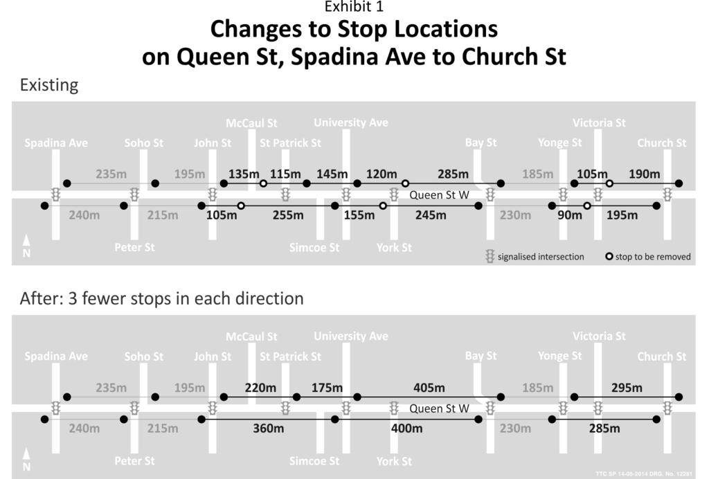
4 CUSTOMER JOURNEY TIMES: TRANSIT STOPS Page 4 In order to provide a real-life illustration of the changes to streetcar stop locations which these stop-spacing and safety principles would bring about, the attached Exhibit 1 shows the existing and resulting locations of streetcar stops on Queen Street, between Church Street and Spadina Avenue. The stops at Victoria Street, York Street, and McCaul Avenue should all be removed. This would eliminate stops which are less than 200 metres away from adjacent stops, while keeping the maximum distance between stops at approximately 400 metres. In this example, there is an exception: the westbound stop at Simcoe Street would be moved to the signalized Queen Street/Patrick Street intersection, which is the last signalised intersection before the McCaul Street turn-back loop. This westbound-only stop would allow passengers to alight from streetcars before they turn back at McCaul Street. Recommended Modifications to Streetcar Stops There are approximately 550 regular stops on the streetcar routes that operate in mixed traffic - ie. 501 QUEEN, 502 DOWNTOWNER, 503 KINGSTON RD, 504 KING, 505 DUNDAS, 506 CARLTON, and 511 BATHURST routes (these include all stops used by the 508 LAKE SHORE route). In addition, there are 42 Sunday stops on these routes. The planned changes to the existing streetcar stops are: i) Relocation of Stops to Nearby Signals: While not detailed in this report, there are 20 stops which are currently at unsignalised locations which will be moved a short distance to a nearby signal or PXO, in the interests of enhanced safety for people crossing the street, and improved consistency regarding stops locations for approaching motorists; ii) iii) Sunday Stops: all Sunday stops will be eliminated. These are listed in Appendix I; and Removal of Closely-Spaced Streetcar Stops: There are 39 regular stops which are less than 200 metres from an adjacent stop, which will be removed. Table 1 lists these stops, and notes the stops where the local Councillor has expressed opposition to the removal of particular stops. There are a further eleven stops that are less than 200 metres from an adjacent stop which had initially been planned for removal. However, as a result of the consultation process, for specific reasons explained in the following section, they will be subject to further study before a final decision is made. Staff will later provide an update report to the Board on these stops. Results of Consultation Placing stops at traffic signals or PXO s and eliminating existing stops which are less than 200 metres apart, including all Sunday stops, were discussed with the TTC s Advisory Committee on Accessible Transportation (ACAT), the TTC s Customer Liaison Panel, and the Councillors in those wards where modifications are being proposed to streetcar stops. The TTC s Customer Liaison Panel strongly endorsed these proposals with respect to streetcar stop placement.
5 CUSTOMER JOURNEY TIMES: TRANSIT STOPS Page 5 Staff met with the ACAT Service Planning Subcommittee on February 21, 2014, and they clearly recognized the difficulty in finding the best balance between placing stops close enough to allow convenient access to stops -- particularly for customers with mobility challenges while still providing a quality trip for customers on-board the streetcar. They concluded that the approach to streetcar-stop placement was reasonable. Staff presented several examples of stops which are too close and should be removed, including examples of closely-spaced stops which require further study because of proximity to, say, hospitals. ACAT agreed with this extra attention to such situations, and requested that similar studies be conducted at closely-spaced stops that are adjacent to seniors facilities and community centres. As a result of the consultations, staff have identified eleven stops which are unacceptably close together, but which will be subject to further study before a final decision is made: the stops on Queen at Victoria, and on Dundas at Elizabeth: these will be surveyed to determine the number of customers using them for the specific purpose of accessing the nearby hospitals; the southbound stop on Broadview at Jack Layton Way: this stop will also be assessed to determine those customers using it to access the adjacent hospital and, if it is retained, the corresponding northbound stop at this intersection a Sunday stop - would also be retained, as a regular stop: the stops on Queen at Empire: there is a Community Centre nearby, and these stops will be studied to determine the number of elderly customers using them to access that facility; the southbound stop on Broadview at Danforth is adjacent to a Toronto Community Housing seniors home and, although Broadview Station is just across the street, the local Councillor is concerned that the removal of this stop would require seniors to cross Broadview Avenue to reach the station. Therefore, staff will determine the number of residents from the seniors home who use this stop; and the stops on Gerrard at Ashdale: these stops are immediately adjacent to a school and staff will review the student use of the stops in directions. In the consultations with local Councillors, there were no objections to moving stops to nearby signals or PXO s. There was acceptance of the plans to remove Sunday stops with two exceptions; Councillor Fletcher asked that the northbound Sunday stop on Broadview at Simpson be retained, given the proximity to the adjacent hospital. As indicated above, TTC staff will assess the merits of establishing a regular stop at that location. Councillor Fletcher also requested that the eastbound Sunday stop on Queen at Booth be retained, given its proximity to the Jimmie Simpson Recreation Centre. This stop, served only on Sundays, is only 90 metres from the following regular stop, at Logan, and is not necessary. Aside from the above, there are 39 stops that are planned for removal, as listed in Table 1, attached. Twelve of the removals are opposed by the local Councillor. These objections are indicated in the table with an asterisk (*). Appendix 2 provides information on each of these twelve stop locations, including why the stops should still be removed.
6 CUSTOMER JOURNEY TIMES: TRANSIT STOPS Page 6 Next Steps and Timing The stops which are to be moved to a nearby signal or PXO and require only the relocation of the stop marker will be completed this year. The removal of all Sunday stops will be completed this year. Advance notice will be provided at all of these stops prior to their removal. The stops which involve the relocation of an accompanying transit shelter will be moved later, probably in All stop removals, other than Sunday stops, will be delayed until at least In some situations for example, the removal of the stops on Queen at York Street the stops will be removed only when the new, longer streetcars are operating on that route. The new streetcars will have all-door boarding, so the passenger service time at the following stop, at University, will be reduced, even with the additional customers who will shift over from the York Street stop. In addition, as customers become accustomed to the all-door loading, they will naturally spread out along the sidewalk for the length of the new streetcar and, in doing so, alleviate some of the existing sidewalk congestion that occurs immediately adjacent to the stop marker, where most customers congregate waiting to board via the front door. All stop removals will be preceded by an advance notice of the reason for, and timing of the removal. JUSTIFICATION The Board should endorse the streetcar stop elimination and relocations described in this report, in order to improve the safety of customers when crossing to or from transit stops and to improve the operating speed, on-board travel experience, and travel time competitiveness of TTC services Attachments: Table 1 Appendices 1 & 2 Exhibit 1
7 CUSTOMER JOURNEY TIMES: TRANSIT STOPS Page 7 Table 1: Stops To Be Removed * indicates Councillor objection to removal ROUTE LOCATION DIRECTION 511 BATHURST Bathurst at Bloor # 276 Adelaide* northbound southbound 501 QUEEN Lake Shore at Summerhill Lake Crescent. Queen at Abell/Beaconsfield* McCaul York Carolyn/Brooklyn* eastbound Consolidate the stops at Connaught, and at Woodward/Kent, into a single location midway between at Woodfield Consolidate the stops at Waverly and at Lee single location midway between - at Bellefair into a 504 KING King at Broadview at Erindale at Brant Simcoe York Trinity* Victoria Mt. Stephen* Broadview westbound westbound 505 DUNDAS Dundas at St. Helens Sheridan* Bellwoods Chestnut Victoria eastbound eastbound
8 CUSTOMER JOURNEY TIMES: TRANSIT STOPS Page 8 Appendix 1: Sunday Stops to be Eliminated Bathurst Street: northbound opposite # 276 Queen Street: King Street: College Street: Dundas Street: Broadview Avenue: Gerrard Street: Kingston Road: eastbound at Callendar, Cowan, Walnut, Power, and Booth, westbound at Bellwoods, Trefan, in directions at Hiawatha, Rhodes and Howland in directions at Close, westbound at Cowan in directions at St. Clarens, Sheridan, Gladstone, Palmerston, and midway between University and Elizabeth in directions at St. Clarens, Bond, and Regent northbound at Simpson, directions at Bain in directions at Glenmore in directions, west of Malvern Note the Sunday stops on Queen, eastbound at Beatty, and eastbound at Glen Manor, are at traffic signals and will be made regular stops
9 CUSTOMER JOURNEY TIMES: TRANSIT STOPS Page 9 Appendix 2: Stop Removals to Which Councillors Have Objected 1. Bathurst at Adelaide: Councillor Vaughan requested further study before removing the stops at Adelaide to ensure that future increases in customer demand from several major developments planned in this area would not result in crowding on the streetcar island platform at the adjacent stops at King or Queen. Staff Response: The Adelaide stops are 140 metres from the stops at King Street and this is too close. Councillor Vaughan s concerns are understandable, but they are speculative at this point, and should not be the basis for retaining such closely-based stops. If the stops at Adelaide are removed, and a crowding problem arises at the streetcar platforms at King and/or Queen in the future due to significant increases in customer demand in this area, then a stop and island passenger platform could be re-instituted at Adelaide. 2. Queen at Abell/Beaconsfield: Councillor Bailão wants to keep these stops midway between the adjacent stops at Gladstone and Dovercourt. She is discussing the possibility of a traffic signal at this location with City staff. She is also concerned that the removal of the stop would result in more people waiting at the adjacent stops, thus creating sidewalk crowding. Staff Response: The eastbound stop at Abell is only 162 metres from the following stop at Davenport; the westbound stop at Beaconsfield is 192 metres from the next stop at Gladstone. With these stops removed, the stop spacing will be just below 400 metres. If a traffic signal were to be installed at Beaconsfield in the future, this decision will be revisited but, at this time, leaving the stops in would be inconsistent with the intent of having all streetcar stops located at traffic signals or PXO s. At present, most customers waiting at a streetcar stop tend to congregate near the intersection, near where they expect to board via the front doors. However, with the new streetcars, customers will board at all of the doors, and will become accustomed to spreading out along the sidewalk. This will alleviate sidewalk congestion that now occurs. 3. Queen at York: Councillor McConnell wants to retain the westbound stop at York (technically in Councillor Wong-Tam s ward), because its removal would result in more people waiting at the stop at University, where the sidewalk is often congested. She requested further study regarding the removal of the eastbound stop. Staff Response: As seen in Exhibit 1, the westbound stop is only 120 metres from the following stop at University, which is unacceptably close. These stops will not be removed until the new streetcars are operating. As indicated above, the new streetcars will have all-door boarding, and people waiting for a streetcar will become accustomed to spreading out along the sidewalk, and not congregate near the intersection as they do today. This will result in less congestion on the north-east corner of University, even with some customers moving over from the current stop at York.
10 CUSTOMER JOURNEY TIMES: TRANSIT STOPS Page Queen at Carolyn/Brooklyn: Councillor Fletcher wants to retain this pair of stops. The streets are offset Brooklyn is a short distance west of Carolyn and neither is signalized. Staff Response: The resulting spacing, with the stops removed, is just over 400 metres. There is not sufficient justification to keep stops which would not have the safety benefits of traffic signals or a PXO. 5. King at Trinity: Councillor McConnell is concerned that there are many customers, including tourists, destined to the areas immediately adjacent to Trinity, south of Queen, and that the elimination of this pair of stops will create an inconvenience and possible confusion. Staff Response: Trinity is not signalized and the distance between stops is roughly 150 metres. With the elimination of the stops at Trinity, the stop spacing between the next-closest adjacent stops at Parliament and Sackville would be 285 metres in the westbound direction, and 345 metres in the eastbound direction. The extra walking distance from the adjacent stops to Trinity -- approximately 150 metres -- is not a significant inconvenience to customers. 6. Dundas at Sheridan: Councillor Bailão wants to maintain the current stops at this signalized intersection, because of plans for an eight-storey apartment building on the northeast corner. Staff Response: The distance from Sheridan to the next-closest stops at Brock is only 150 metres in the westbound direction and 160 metres to Dufferin in the eastbound direction. With the Sheridan stops removed, the resulting stop spacing between Brock and Dufferin is about 345 metres. 7. Broadview at Mt. Stephen: Councillor Fletcher wants to keep this stop, which is between Dundas Street East and Gerrard Street East. Staff Response: The northbound stop at this unsignalised intersection is only 160 metres south of the next stop at Gerrard; the southbound stop is 175 metres from Dundas Street. The resulting stop spacing, with the stops at Mt. Stephen removed, is 350 metres in the northbound direction and 355 metres in the southbound direction, and these distances are acceptable.
11
TORONTO TRANSIT COMMISSION REPORT NO.
 Revised: March/13 TORONTO TRANSIT COMMISSION REPORT NO. MEETING DATE: January 28, 2014 SUBJECT: IMPROVING PEDESTRIAN SAFETY AND CUSTOMER JOURNEY TIMES: TRANSIT STOPS ACTION ITEM RECOMMENDATIONS It is recommended
Harbord Street and Hoskin Avenue Bicycle Lane Upgrades
 STAFF REPORT ACTION REQUIRED and Bicycle Lane Upgrades Date: April 22, 2014 To: From: Wards: Reference Number: Public Works and Infrastructure Committee General Manager, Transportation Services 19 and
Evaluation and Changes to Pedestrian Priority Phase Signal (Scramble Crossing) at Bay Street and Bloor Street
 at Bay Street and Bloor Street") PW2.2 STAFF REPORT ACTION REQUIRED Evaluation and Changes to Pedestrian Priority Phase Signal (Scramble Crossing) at Bay Street and Bloor Street Date: February 12, 2015 To: From: Public Works and Infrastructure
PW2.2 STAFF REPORT ACTION REQUIRED Evaluation and Changes to Pedestrian Priority Phase Signal (Scramble Crossing) at Bay Street and Bloor Street Date: February 12, 2015 To: From: Public Works and Infrastructure
KING STREET TRANSIT PILOT
 STREET TRANSIT PILOT Update toronto.ca/kingstreetpilot #kingstreetpilot HIGHLIGHTS PREVIOUS HIGHLIGHTS TRANSIT RELIABILITY TRANSIT TRAVEL TIMES 85% of streetcars arriving within 4 minutes westbound during
Improving Cyclist Safety at the Dundas Street West and Sterling Road Intersection
 STAFF REPORT ACTION REQUIRED Improving Cyclist Safety at the Dundas Street West and Sterling Road Intersection Date: August 17, 2012 To: From: Wards: Reference Number: Public Works and Infrastructure Committee
Richmond-Adelaide Cycle Tracks
 Public Drop-In Event Richmond-Adelaide Cycle Tracks June 25, 2018 12:00 p.m. 3:00 p.m. 4:30 p.m. 7:30 p.m. Metro Hall, Rotunda 55 John Street 1 Purpose of Event In Scope Communicate an update about the
Traffic Control Signals Review 4325 McCowan Road
 REPORT FOR ACTION Traffic Control Signals Review 4325 McCowan Road Date: March 15, 2018 To: Scarborough Community Council From: Director, Transportation Services, Scarborough District Wards: Ward 41 Scarborough
Corporate. Report COUNCIL DATE: May 25, 1998 NO: R1500 REGULAR COUNCIL. TO: Mayor & Council DATE: April 27, 1998
 R1500 : Traffic Safety at 25 Avenue and 128 Street Intersection Corporate NO: R1500 Report COUNCIL DATE: May 25, 1998 REGULAR COUNCIL TO: Mayor & Council DATE: April 27, 1998 FROM: General Manager, Engineering
Traffic Control Signals - Cosburn Avenue and Cedarvale Avenue
 REPORT FOR ACTION Traffic Control Signals - Cosburn Avenue and Cedarvale Avenue Date: April 24, 2017 To: Toronto and East York Community Council From: Acting Director, Transportation Services, Toronto
Transportation Impacts: Toronto York Spadina Subway Extension
 STAFF REPORT ACTION REQUIRED Transportation Impacts: Toronto York Spadina Subway Extension Date: June 6, 2011 To: From: Wards: Reference Number: North York Community Council Director, Transportation Services
MEETING DATE: DECEMBER 9, SUBJECT: Use Of Cameras To Enforce Transit Lanes RECOMMENDATIONS. It is recommended that the Commission:
 MEETING DATE: DECEMBER 9, 2002 SUBJECT: Use Of Cameras To Enforce Transit Lanes RECOMMENDATIONS It is recommended that the Commission: 1. Receive this report for information, noting that; several major
TRANSPORTATION IMPACT STUDY
 Dundas MEP Developments Inc. City of Toronto 219 and 231 Dundas Street East, Proposed Mixed-Use Development TRANSPORTATION IMPACT STUDY 9782/2 April 216 LEA Consulting Ltd. Consulting Engineers & Planners
Toronto and East York Community Council. Director, Transportation Services, Toronto and East York District
 No Turn on Red Regulations STAFF REPORT ACTION REQUIRED Date: June 1, 2010 To: From: Toronto and East York Community Council Director, Transportation Services, Toronto and East York District Wards: Trinity
Public Works and Infrastructure Committee. General Manager, Transportation Services
 STAFF REPORT ACTION REQUIRED Extending the Bay Street Bicycle Lanes Date: May 16, 2013 To: From: Public Works and Infrastructure Committee General Manager, Transportation Services Wards: Toronto Centre
Bicycle Traffic Control Signal - St. Clair Avenue West and Poplar Plains Road
 PW17.11 REPORT FOR ACTION Bicycle Traffic Control Signal - St. Clair Avenue West and Poplar Plains Road Date: November 4, 2016 To: Public Works and Infrastructure Committee From: Acting General Manager,
Southwest Bus Rapid Transit (SW BRT) Functional Planning Study - Executive Summary January 19 LPT ATTACHMENT 2.
 Functional Planning Study - Executive Summary January 19 LPT ATTACHMENT 2.") Southwest Bus Rapid Transit (SW BRT) Functional Planning Study - Executive Summary 2011 January 19 1 of 19 Introduction This executive summary presents the results of the Southwest Bus Rapid Transit (SW
Southwest Bus Rapid Transit (SW BRT) Functional Planning Study - Executive Summary 2011 January 19 1 of 19 Introduction This executive summary presents the results of the Southwest Bus Rapid Transit (SW
Traffic Control Signals Cosburn Avenue and Todmorden Lane/ Private Access
 REPORT FOR ACTION Traffic Control Signals Cosburn Avenue and Todmorden Lane/ Private Access Date: May 25, 2017 To: Toronto and East York Community Council From: Acting Director, Transportation Services,
As the Toronto Transit Commission (TTC) operates a transit service on Avenue Road, City Council approval of this report is required.
 operates a transit service on Avenue Road, City Council approval of this report is required.") REPORT FOR ACTION Corridor Safety Review - Avenue Road Date: September 27, 2017 To: Toronto and East York Community Council From: Acting Director, Transportation Services, Toronto and East York District
REPORT FOR ACTION Corridor Safety Review - Avenue Road Date: September 27, 2017 To: Toronto and East York Community Council From: Acting Director, Transportation Services, Toronto and East York District
Appendix 1 Transit Network Analysis
 Appendix 1 Transit Network Analysis APPENDIX 1 TRANSIT NETWORK ANALYSIS The purpose of this appendix is to provide an update on the transit network analysis as it pertains to: i. SmartTrack ii. Scarborough
Having held a public hearing, that Council approve:
 3. MODIFICATIONS TO MERIVALE ROAD FROM FALLOWFIELD ROAD TO OLD HIGHWAY 16 TO ACCOMMODATE THE GROWTH WITHIN THE SOUTH MERIVALE BUSINESS PARK - PUBLIC HEARING COMMITTEE RECOMMENDATIONS Having held a public
Public Event 1 Community Workshops
 Public Event 1 Community Workshops Nov. 24 & Dec. 3, 2016 Welcome Workshop Purpose We re looking to you for ideas and insights to help guide future transportation infrastructure planning in the Park Lawn
Richmond Street and Adelaide Street Cycle Tracks
 IE1.05 REPORT FOR ACTION Richmond and Cycle Tracks Date: January 3, 2019 To: Infrastructure and Environment Committee From: General Manager, Transportation Services Wards: 10 (Spadina-Fort York), 13 (Toronto
Contents. Champaign-Urbana Mass Transit District Stop Placement Guidelines
 Contents Champaign-Urbana Mass Transit District Introduction... 1 Stop Spacing... 2 Rural... 2 Low Density Suburban... 2 General Urban... 2 Urban Core... 2 Operational Safety... 3 Stop Placement... 4 Nearside
Construction Staging Area Vaughan Road
 REPORT FOR ACTION Construction Staging Area - 109 Vaughan Road Date: May 25, 2017 To: Toronto and East York Community Council From: Acting Director, Transportation Services, Toronto and East York District
Traffic Calming St. Clarens Avenue between Brandon Avenue and Davenport Road
 STAFF REPT ACTION REQUIRED Traffic Calming St. Clarens Avenue between Brandon Avenue and Davenport Road Date: February 2, 2012 To: From: Wards: Reference Number: Etobicoke York Community Council Acting
Road Alterations - Wellington Street East, Church Street, and Front Street Intersection
 REPORT FOR ACTION Road Alterations - Wellington Street, Church Street, and Front Street Intersection Date: November 1, 2016 To: Toronto and York Community Council From: Director, Public Realm Section,
APPENDIX 2 LAKESHORE ROAD TRANSPORTATION REVIEW STUDY EXECUTIVE SUMMARY
 APPENDIX 2 LAKESHORE ROAD TRANSPORTATION REVIEW STUDY EXECUTIVE SUMMARY Appendix 2 City of Mississauga Lakeshore Road FINAL REPORT Transportation Review Study December 2010 EXECUTIVE SUMMARY Study Purpose
REPORT. Engineering and Construction Department
 REPORT COMMUNITY SERVICES COMMITTEE MEETING DATE: JUNE 11, 2013 FROM: Engineering and Construction Department DATE: May 24, 2013 SUBJECT: Great Lakes Boulevard Mini Roundabout LOCATION: Great Lakes Boulevard
Bloor Street Design Feasibility Study and Bike Lane Pilot Project. Public Works and Infrastructure Committee
 PW12.1 STAFF REPORT ACTION REQUIRED Design Feasibility Study and Bike Lane Pilot Project Date: March 30, 2016 To: From: Wards: Reference Number: Public Works and Infrastructure Committee General Manager,
The following notes describe comments received that were written/drawn on maps by workshop participants.
 Stakeholder Workshop Additional Feedback Received Maps and Comment Forms October 5, 2016 The following notes describe comments received that were written/drawn on maps by workshop participants. MAP 1 MAP
Roadways. Roadways III.
 Introduction 97 Roadway Design Principles 98 Safe Speeds 99 Optimizing of Street Space 00 Minimum Lane Widths in the City of Boston 02 Design Features that Reduce Operating Speeds 05 Travel Lanes Transit
Pedestrian Crossing Guidelines 2016
 Pedestrian Crossing Guidelines 2016 Engineering Services 1.0 Introduction and Background The City of Kingston s first Pedestrian Crossing Guidelines were approved by Council in 2008 in order to provide
Executive Summary BEYOND THE B-LINE: RAPID TRANSIT LINE PHASE II - COMMERCIAL DRIVE WEST. Final Draft December 13, Appendix B BROADWAY/LOUGHEED
 BEYOND THE B-LINE: BROADWAY/LOUGHEED RAPID TRANSIT LINE PHASE II - COMMERCIAL DRIVE WEST Appendix B Executive Summary Final Draft December 13, 1999 UMA Lloyd Lindley Davidson Yuen Simpson Architects BROADWAY/LOUGHEED
M-58 HIGHWAY ACCESS MANAGEMENT STUDY Mullen Road to Bel-Ray Boulevard. Prepared for CITY OF BELTON. May 2016
 M-58 HIGHWAY ACCESS MANAGEMENT STUDY Prepared for CITY OF BELTON By May 2016 Introduction Missouri State Highway 58 (M-58 Highway) is a major commercial corridor in the City of Belton. As development has
Correspondence received requesting that the streetcar stop at King and Trinity Streets not be removed PRESENTED TO THE BOARD MAY
 Correspondence received requesting that the streetcar stop at King and Trinity Streets not be removed PRESENTED TO THE BOARD MAY 2 8 2014 From: Julie Beddoes, 39 Parliament St., #506, Toronto, M5A 4R2
Cycling Facilities on Woodbine Avenue and Corley Avenue
 PW15.10 REPORT FOR ACTION Cycling Facilities on and Corley Date: September 13, 2016 To: Public Works and Infrastructure Committee From: Acting General Manager, Transportation Services Wards: Ward 31 -
2. KING EDWARD AVENUE AND ST. PATRICK STREET - SAFETY IMPROVEMENT
 2. KING EDWARD AVENUE AND ST. PATRICK STREET - SAFETY IMPROVEMENT COMMITTEE RECOMMENDATION That Council approve the construction of the proposed modifications for the intersection of King Edward Avenue
Richmond, Adelaide and Simcoe Street Pilot Cycle Tracks. Public Consultation December 2014 to May 2015 Summary Report
 Richmond, Adelaide and Simcoe Street Pilot Cycle Tracks Public Consultation December 2014 to May 2015 Summary Report Prepared by: Jason Diceman, Sr. Public Consultation Coordinator Public Consultation
7 June 2018 OUR REF:
 7 June 2018 OUR REF: 476729-01000 Mirtillo Estates Inc. 1681 Langstaff Road, Unit 1 Vaughan, Ontario, L4K 5T3 Attention: Joran Weiner Vice-President Dear Mr. Weiner: Re: Mirtillo Estates Sales Office Transportation
We support several of Regional Municipality of Durham Transportation Master Plan Directions such as
 OATAC-17-26 Relates to Item 1 of the O.A.T.A.C. Report (DS-17-164) We support several of Regional Municipality of Durham Transportation Master Plan Directions such as Direction 3: Make walking and cycling
COMMITTEE RECOMMENDATIONS. That Council approve:
 4. MODIFICATIONS TO INNES ROAD (REGIONAL ROAD 30) AND TENTH LINE ROAD (REGIONAL ROAD 47) TO ACCOMMODATE THE DEVELOPMENT OF THE TRINITY COMMONS SHOPPING CENTRE COMMITTEE RECOMMENDATIONS That Council approve:
Dowling/Beaty Cycling Route
 Public Meeting #2 Dowling/Beaty Cycling Route May 17, 2017 6:00 p.m. 8:00 p.m. Parkdale Public Library - Auditorium 1303 Queen Street West How to Participate Share your questions, ideas and concerns We
The General Manager, Transportation Services recommends that:
 PW28.7 REPORT FOR ACTION Road Classification Amendments Date: March 26, 2018 To: Public Works and Infrastructure Committee From: General Manager, Transportation Services Wards: 15, 19, 20, 23, 24, 29,
TORONTO TRANSIT COMMISSION REPORT NO.
 Form Revised: February 2005 TORONTO TRANSIT COMMISSION REPORT NO. MEETING DATE: February 18, 2009 SUBJECT: EXPRESS BUS CHANGES ACTION ITEM RECOMMENDATION It is recommended that the Commission forward this
TRANSIT SIGNAL PRIORITY The Toronto Experience
 TRANSIT SIGNAL PRIORITY The Toronto Experience July 27, 2004 July 27, 2004 1 Warning This presentation contains graphic images depicting serious violations to the coordination of traffic signals and may
10.0 CURB EXTENSIONS GUIDELINE
 10.0 CURB EXTENSIONS GUIDELINE Road Engineering Design Guidelines Version 1.0 March 2017 City of Toronto, Transportation Services City of Toronto Page 0 Background In early 2014, Transportation Services
2014/2015 BIKE ROUTE PLAN 83 AVENUE PROTECTED BIKE LANE
 About the Project 2014/2015 BIKE ROUTE PLAN The City of Edmonton is planning a major bike route on the south side of Edmonton. This bike route is one part of a plan to provide citizens with transportation
INTRODUCTION DISCUSSION
 INTRODUCTION A study released by the Toronto Board of Trade reports that Toronto s traffic congestion has grown into a serious and costly problem. It states that Toronto commuters spend about 80 minutes
June 29, Dear Mr. Walter:
 From: CountyBoard@arlingtonva.us To: chickandsandy@msn.com Subject: County Board Response Regarding the Arlington Ridge Road Improvement Project (Intranet Quorum IMA00252707) Date: Wed, 29 Jun 2011 08:09:53-0400
2. NORTEL CARLING CAMPUS EXPANSION - PROPOSED MODIFICATIONS TO MOODIE DRIVE (REGIONAL ROAD 59) AND HIGHWAY 417 INTERCHANGE
 AND HIGHWAY 417 INTERCHANGE") 2. NORTEL CARLING CAMPUS EXPANSION - PROPOSED MODIFICATIONS TO MOODIE DRIVE (REGIONAL ROAD 59) AND HIGHWAY 417 INTERCHANGE COMMITTEE RECOMMENDATIONS AS AMENDED That Council approve: 1. The endorsement
2. NORTEL CARLING CAMPUS EXPANSION - PROPOSED MODIFICATIONS TO MOODIE DRIVE (REGIONAL ROAD 59) AND HIGHWAY 417 INTERCHANGE COMMITTEE RECOMMENDATIONS AS AMENDED That Council approve: 1. The endorsement
South Street Campus Lands Development. City of London TRANSPORTATION IMPACT ASSESSMENT
 South Street Campus Lands Development City of London TRANSPORTATION IMPACT ASSESSMENT TW1387 South Street Campus Lands Development City of London TRANSPORTATION IMPACT ASSESSMENT May 2013 South Street
Providence Downtown Transit Connector STAKEHOLDER MEETING #2. Stakeholder Meeting #1 October 24, 2016
 Providence Downtown Transit Connector STAKEHOLDER MEETING #2 Stakeholder Meeting #1 October 24, 2016 February 2017 1 AGENDA 1 DTC Goals and Expectations 2 Street Design Concepts 3 Potential Benefits and
Richmond Adelaide Cycle Track Planning and Design Study Pilot Project
 STAFF REPORT ACTION REQUIRED Cycle Track Planning and Design Study Pilot Project Date: April 22, 2014 To: From: Wards: Reference Number: Public Works and Infrastructure Committee General Manager, Transportation
ALTERNATIVE A ONLY. Right Turn Only. BOTH ALTERNATIVES on southbound Mission from 23rd St to 25th St and on northbound Mission from 20th St to 23rd St
 Proposal Detail: 22nd on southbound Mission from on both sides of Mission from to 23rd from at northbound Mission and 22nd St and at at northbound Mission and 23rd St Reconfigure Lanes ONLY No Parking
Main-McVay Transit Study: Phase 2 Options Definition and High Level Constraints Evaluation
 Main-McVay Transit Study: Phase 2 Options Definition and High Level Constraints Evaluation APRIL 2016 A collaborative study between: For Additional Information or to Comment If you would like additional
Downtown Transportation Operations Study
 Attachment 2 - Project s Project 1 Downtown Transportation Operations Project Implementation Team Establish a Downtown Transportation Operations Project Implementation Committee and Action Team to develop,
Draft North Industrial Area-Wide Traffic Plan
 Summary of North Industrial and Hudson Bay Industrial Recommended Improvements Table 1. Summary of s Item Location 1 2 3 4 5 6 7 8 9 10 11 12 Millar Ave north of 51st St Super 8 Motel back lane 400 Block
Seattle Department of Transportation (SDOT) Preliminary Responses to Madison-Miller Community List of Site-Specific Concerns
 Preliminary Responses to Madison-Miller Community List of Site-Specific Concerns") Seattle Department of Transportation (SDOT) Preliminary Responses to Madison-Miller Community List of Site-Specific Concerns Background In July 2002 SDOT staff met with a small group of community residents
Seattle Department of Transportation (SDOT) Preliminary Responses to Madison-Miller Community List of Site-Specific Concerns Background In July 2002 SDOT staff met with a small group of community residents
Appendix C. NORTH METRO STATION AREA TRAFFIC IMPACT STATEMENT 88th Avenue Station
 Appendix C NORTH METRO STATION AREA TRAFFIC IMPACT STATEMENT 88th Avenue Station Prepared for: Regional Transportation Department and URS Corporation as part of the North Metro EIS David Evans and Associates,
September 2017 I City of New Westminster
 September 2017 I City of New Westminster Page 1 1. Context Sapperton is a predominantly residential community and home to the Royal Columbian Hospital (RCH). The neighbourhood is undergrowing major growth
FEEDBACK SURVEY #2: WHO PARTICIPATED
 Attachment 2 - Summary of Public Opinion Survey Results Attachment 2 FEEDBACK SURVEY #2: WHO PARTICIPATED Online for public input from December 13, 2016 to May 4, 2017 Promoted through 30,000 flyers, sharing
Pedestrian Crossing Protection Review - Howard Street
 REPORT FOR ACTION Pedestrian Crossing Protection Review - Howard Street Date: May 5, 2017 To: Toronto and East York Community Council From: Acting Director, Transportation Services, Toronto and East York
DEPARTMENT OF ENVIRONMENTAL SERVICES. North Harrison Street (Lee Highway to Little Falls Road) Comparative Analysis. Prepared for:
 Comparative Analysis. Prepared for:") DEPARTMENT OF ENVIRONMENTAL SERVICES North Harrison Street (Lee Highway to Little Falls Road) Comparative Analysis Prepared for: Arlington County Department of Environmental Services 2100 Clarendon Boulevard,
DEPARTMENT OF ENVIRONMENTAL SERVICES North Harrison Street (Lee Highway to Little Falls Road) Comparative Analysis Prepared for: Arlington County Department of Environmental Services 2100 Clarendon Boulevard,
4 DISRUPTION MANAGEMENT PLAN HIGHWAY 7 RAPIDWAY CONSTRUCTION BETWEEN BAYVIEW AVENUE AND WARDEN AVENUE TOWNS OF MARKHAM AND RICHMOND HILL
 4 DISRUPTION MANAGEMENT PLAN HIGHWAY 7 RAPIDWAY CONSTRUCTION BETWEEN BAYVIEW AVENUE AND WARDEN AVENUE TOWNS OF MARKHAM AND RICHMOND HILL The Transportation Services Committee recommends the adoption of
2. Executing a legal agreement with respect to (1) above.
 above.") 3. INSTALLATION OF TRAFFIC CONTROL SIGNALS AT HUNT CLUB AND PAUL ANKA TO ACCOMMODATE THE DEVELOPMENT OF A GAS BAR, CONVENIENCE STORE AND CAR WASH COMMITTEE RECOMMENDATIONS That Council approve the installation
3. INSTALLATION OF TRAFFIC CONTROL SIGNALS AT HUNT CLUB AND PAUL ANKA TO ACCOMMODATE THE DEVELOPMENT OF A GAS BAR, CONVENIENCE STORE AND CAR WASH COMMITTEE RECOMMENDATIONS That Council approve the installation
Appendix A-K Public Information Centre 2 Materials
 Appendix A-K Public Information Centre 2 Materials Our Rapid Transit Initiative Make an impact on the future of transit Join the discussion on Rapid Transit in London You re invited to a Public Information
Memorandum. Sunday, July 13, Saturday, July 19, 2014
 Memorandum To: David Lowin, Brooklyn Bridge Park Corporation From: Daniel Schack, AICP, PTP Date: Re: Brooklyn Bridge Park Pier 5/6 Loop Road Traffic Study Project No: 14-01-2407 At the request of Brooklyn
TRAFFIC IMPACT ANALYSIS
 TRAFFIC IMPACT ANALYSIS FOR THE CHAMPAIGN UNIT#4 SCHOOL DISTRICT PROPOSED HIGH SCHOOL (SPALDING PARK SITE) IN THE CITY OF CHAMPAIGN Final Report Champaign Urbana Urbanized Area Transportation Study 6/24/2014
AGENDA ITEM 6 D THOMASVILLE ROAD (HERMITAGE BOULEVARD TO LIVE OAK PLANTATION ROAD) ROADWAY SAFETY AUDIT
 ROADWAY SAFETY AUDIT") May 15, 2018 AGENDA ITEM 6 D THOMASVILLE ROAD (HERMITAGE BOULEVARD TO LIVE OAK PLANTATION ROAD) ROADWAY SAFETY AUDIT TYPE OF ITEM: Discussion STATEMENT OF ISSUE The Florida Department of Transportation
May 15, 2018 AGENDA ITEM 6 D THOMASVILLE ROAD (HERMITAGE BOULEVARD TO LIVE OAK PLANTATION ROAD) ROADWAY SAFETY AUDIT TYPE OF ITEM: Discussion STATEMENT OF ISSUE The Florida Department of Transportation
EXECUTIVE SUMMARY OF CALEDON TRANSPORTATION NEEDS STUDY
 EXECUTIVE SUMMARY OF CALEDON TRANSPORTATION NEEDS STUDY The Caledon Transportation Needs Study has been undertaken as a joint project by the Town of Caledon and the Region of Peel to determine the existing
CURBSIDE ACTIVITY DESIGN
 5 CURBSIDE ACTIVITY DESIGN This chapter provides design guidance for separated bike lanes adjacent to curbside activities including parking, loading and bus stops. Typical configurations are presented
ALTERNATIVES TO BE CONSIDERED
 ALTERNATIVES TO BE CONSIDERED EXISTING CONDITIONS (BASE CASE) In order to evaluate and understand the potential benefits and impacts of introducing downtown transit improvements in Providence, a Base Case
Glebe Neighbourhood Cycling Plan
 Glebe Neighbourhood Cycling Plan Summary of Public Comments received after June 5 th Public Information Session Comment STUDY NETWORK CS9, CS8, E, E0 CS4, E CS4 CS8 E Suggestions for alternate cycling
DUNDAS WEST-BLOOR Mobility Hub Profile
 Mobility Hub Profile Dundas West-Bloor Anchor Hub Gateway Hub N MOBILITY HUBS: Places of connectivity between regional and rapid transit services, where different modes of transportation come together
Governance and Priorities Committee Report For the July 2, 2015 Meeting
 CITY OF VICTORIA For the July 2, 2015 Meeting To: Governance and Priorities Committee Date: From: Subject: Brad Dellebuur, A/Assistant Director, Transportation and Parking Services Executive Summary The
City of Kingston Report to Council Report Number
 To: From: Resource Staff: Date of Meeting: June 16, 2015 Subject: City of Kingston Report to Council Report Number 15-291 Mayor and Members of Council Jim Keech, President and CEO, Utilities Kingston Mark
Upper Market Street Bike Lane Project
 Upper Market Street Bike Lane Project 17th Street to Octavia Boulevard 6 30 2010 SAN FRANCISCO, CALIFORNIA Agenda San Francisco & Sustainable Transportation Project Goals Outreach & Coordination Project
Appendix B Workshop Materials
 Appendix B Workshop Materials Public Event 1 Community Workshops Nov. 24 & Dec. 3, 2016 Welcome Workshop Purpose We re looking to you for ideas and insights to help guide future transportation infrastructure
1. Provide a dedicated westbound approach bus lane at the intersection;
 3. MODIFICATIONS AT HIGHWAY 417 WESTBOUND OFF-RAMP/PINCREST ROAD - PUBLIC HEARING COMMITTEE RECOMMENDATIONS Having held a public hearing, that Council approve the preliminary design for the proposed modifications
Station Plan: Penn & 43rd Avenue
 Station Plan: Penn & 43rd Avenue This station will serve the northern portion of the Penn Avenue corridor, including the commercial node at 44th Avenue. Ridership and roadway geometry support station siting
PROPOSED BYLAW UPDATES AND FEES FOR SIDEWALK CAFÉS & MARKETING DISPLAYS
 Transportation Services Municipal Licensing and Standards PROPOSED BYLAW UPDATES AND FEES FOR SIDEWALK CAFÉS & MARKETING DISPLAYS PUBLIC CONSULTATIONS June 13, 2017 Toronto City Hall June 20, 2017 North
DON MILLS-EGLINTON Mobility Hub Profile
 Mobility Hub Profile Dundas Don Mills-Eglinton West-Bloor Anchor Hub Gateway Hub N MOBILITY HUBS: Places of connectivity between regional and rapid transit services, where different modes of transportation
Appendix A. Road Classification Review of Outstanding Issues and Proposed Classifications (All Wards) Staff Report Road Classification System
 Staff Report Road Classification System") Appendix A Road Classification Review of Outstanding Issues and Proposed Classifications (All Wards) Staff Report 2000 A.1 of A.10 A.2 of A.10 STAFF REPORT January 26, 2000 To: From: Works Committee Barry
Appendix A Road Classification Review of Outstanding Issues and Proposed Classifications (All Wards) Staff Report 2000 A.1 of A.10 A.2 of A.10 STAFF REPORT January 26, 2000 To: From: Works Committee Barry
Chapter 7. Transportation. Transportation Road Network Plan Transit Cyclists Pedestrians Multi-Use and Equestrian Trails
 Chapter 7 Transportation Transportation Road Network Plan Transit Cyclists Pedestrians Multi-Use and Equestrian Trails 7.1 TRANSPORTATION BACKGROUND The District of Maple Ridge faces a number of unique
2014/2015 BIKE ROUTE PLAN 83 AVENUE PROTECTED BIKE LANE
 About the Project The City of Edmonton is planning a major bike route on the southside of Edmonton. The Strathcona Bike Route will connect the communities of Strathcona, Garneau and the University area,
Addendum to Mitigated Negative Declaration
 Addendum Date: Case No.: 2014.1499E Project Title: (MDSP) - Mission Valencia Green Gateway Streetscape Project Original: 2008.1075, MDSP Mitigated Negative Declaration Project Sponsor: Charlie Ream, San
TRANSPORT CHICAGO: STRATEGIC PUBLIC TRANSIT BUS RELIABILITY IMPROVEMENTS
 TRANSPORT CHICAGO: STRATEGIC PUBLIC TRANSIT BUS RELIABILITY IMPROVEMENTS Presented by David VanderZee and Jack Chalabian Monday, June 02, 2014 Overview of Strategic Route Management CTA Strategic Route
May 5, 2009 File:
 MMM Group Limited Suite 600 1455 West Georgia Street Vancouver, BC V6G 2T3 t: 604-685-9381 f: 604-683-8655 www.mmm.ca May 5, 2009 File: 50-09001-007 1420 1055 West Hastings Street Vancouver, BC V6E 2E9
Caltrans Sloat Boulevard Pedestrian Safety Project Response to Community Questions, Comments & Concerns
 Caltrans Sloat Boulevard Pedestrian Safety Project Response to Community Questions, Comments & Concerns Revised: May 10, 2016 The California Department of Transportation (Caltrans) is planning various
Traffic Circulation & Pedestrian Safety Study
 Lyons Township High School North Campus La Grange, Illinois Parking Lot Vaughan Building N Main Building Prepared for: Prepared by: July 23, 2015 Contents List of Figures, iii 1. Introduction...1 2. Existing
WEST AND SOUTH WEST RING ROAD DOWNSTREAM TRAFFIC IMPACTS
 Page 1 of 9 EXECUTIVE SUMMARY Alberta Transportation ( AT ) is preparing to construct the final sections of the Calgary Ring Road. This includes the South West Ring Road ( SWRR ) (from Lott Creek Blvd
Board Strategy Day. January 25, 2018
 Board Strategy Day January 25, 2018 Corporate Plan 2018-2022 & beyond Presentation to the board 2018 2022 & beyond 2 Building on the last five-year plan 2013 2017 21% reduction in subway delay minutes
Public Works and Infrastructure Committee. General Manager, Transportation Services. P:\2016\Cluster B\TRA\TIM\pw16009tim.docx
 Ten Year Cycling Network Plan Date: May 3, 2016 STAFF REPORT ACTION REQUIRED PW13.11 To: From: Wards: Reference Number: Public Works and Infrastructure Committee General Manager, Transportation Services
Ridership Growth Strategy. Presentation to the board & beyond 1
 Ridership Growth Strategy Presentation to the board 2018 2022 & beyond 1 Objectives of the Ridership Growth Strategy 1 Retain 2 Increase 3 Attract current customers transit rides per current customer new
CITY OF OTTAWA ROADWAY MODIFICATION APPROVAL UNDER DELEGATED AUTHORITY
 RMA-2015-ATM-038 CITY OF OTTAWA ROADWAY MODIFICATION APPROVAL UNDER DELEGATED AUTHORITY DATE: April 22, 2015 SUBJECT Approval of Roadway Modifications Recommended through an Area Traffic Management Study
5 Transit & Traffic. Overview
 5 Transit & Traffic Overview Montgomery Place s roadways and overall traffic circulation are unique in the city due to the narrow streets and avenues with boulevards; however, no sidewalks or curbs in
TRAFFIC MANAGEMENT PLAN
 292 84 140440 TRAFFIC MANAGEMENT PLAN The purpose of the Traffic Management Plan (TMP) is to have established procedures for traffic flow and circulation around the elementary school related to student
Proposed Bridge Street East Bicycle Lanes Public Open House Thursday, April 27, 2017
 WELCOME Proposed Bridge Street East Bicycle Lanes Public Open House Thursday, April 27, 2017 Purpose of the Open House The purpose of this Open House is to gain public input on the bicycle lanes proposed
Tunnel Reconstruction Brooklyn CB 1 August 14, 2018
 Tunnel Reconstruction Brooklyn CB 1 August 14, 2018 Reconstructing the Tunnel 2 Service During Tunnel Reconstruction April 2019 through July 2020 3 Projected Cross River Travel Paths of Customers The Service
HENDERSON DEVELOPMENT 213, 217, 221, 221 ½, 223 HENDERSON AVENUE and 65 TEMPLETON STREET OTTAWA, ONTARIO TRANSPORTATION OVERVIEW.
 HENDERSON DEVELOPMENT 213, 217, 221, 221 ½, 223 HENDERSON AVENUE and 65 TEMPLETON STREET OTTAWA, ONTARIO TRANSPORTATION OVERVIEW Prepared for: 2294170 Ontario Inc. February 2, 2017 117-652 Report_1.doc