Southampton School District
|
|
|
- Brendan Todd McKinney
- 6 years ago
- Views:
Transcription


1 ww w. dr ive le ss.c om Southampton School District School Travel Plan May, 2014 Sponsored by the New Jersey Department of Transportation with funding from the Federal Highway Administration.

2 Southampton School District Travel Plan Prepared by: Cross County Connection Transportation Management Association May 2014 Cross County Connection Transportation Management Association was formally incorporated in 1989 through efforts of a group of southern New Jersey business leaders, local government officials, and representatives from the New Jersey Department of Transportation and New Jersey Transit Corporation to address mobility issues in the region and reduce the number of vehicles on state and local roadways. Today, Cross County Connection is a non profit organization partnering with the New Jersey Department of Transportation, New Jersey Transit, Federal Highway Administration and its members to provide solutions to complex transportation problems for counties, municipalities, employers and commuters in Atlantic, Burlington, Camden, Cape May, Cumberland, Gloucester and Salem Counties. This Cross County Connection Transportation Management Association publication is funded by the New Jersey Department of Transportation through the U.S. Department of Transportation Federal Highway Administration. The Federal Government and the State of New Jersey assume no liability for the contents. 4A Eves Drive Suite 114 Marlton, NJ CCCTMA@driveless.com
3 TABLE of CONTENTS I. INTRODUCTION 1 Goals 1 School Descriptions 1 Working Group 4 II. EXISTING CONDITIONS 5 Policies and Practices 5 Travel Patterns 6 Vehicular Crashes 6 Travel Safety Concerns 8 Primary School Travel Corridors 9 Race Street 9 Main Street 9 Grange Street 10 Pleasant Street 11 Other Safety Concerns 12 III. ACTIONS 13 Education 13 Encouragement 14 Enforcement 15 Engineering 16 Evaluation 16 IV. RECOMMENDATIONS 18 Bicycle Accommodations 18 Crosswalk Markings 18 Missing Curb Ramps 19 Traffic Control 19 Wayfinding Signage 20 Missing Sidewalks 20 Intersections: Visibility/Safety 20 Project Funding 23 Conclusion 24 Cross County Connection TMA i
4 FIGURES Figure 1. Southampton School District 2 Figure 2. Bicycle Parking at Southampton School District 5 Figure 3. Race Street Facing Red Lion Road 9 Figure 4. Overgrowth on Race Street 9 Figure 5. Intersection of Main Street and Mill Street 10 Figure 6: Grange Street 10 Figure 7: Pleasant Street, in front of School 1 at Miss Mabel Drive 11 Figure 8: No sidewalks along west side of Pleasant Street 11 Figure 9: Crosswalk in front of School 1 12 Figure 10: Entrance to Miss Mabel Drive 12 Figure 11: Golden Sneaker Award 15 Figure 12: Sharrow 18 Figure 13: Crosswalk Treatments 19 Figure 14: Speed Hump 19 Figure 15: SRTS Route Marker 20 MAPS Map 1. Study Area 3 Map 2. Study Area Crossing Guard and Crash Locations 7 Map 3. Study Area Recommended Improvements 22 TABLES Table 1: Southampton Township SRTS Working Group 4 Table 2: Student Population: Commute Mode 6 Table 3: Vehicular Crashes 6 Table 4: Education Actions 13 Table 5: Encouragement Actions 14 Table 6: Enforcement Actions 15 Table 7. Evaluation Actions 16 Cross County Connection TMA ii
5 I. INTRODUCTION Southampton Township is located in central Burlington County, east of Medford Township and north of Tabernacle. Its school district consists of three schools: School 1 (K 2), School 2 (3 5), and School 3 (6 8). All of the schools are centrally located on one campus in the center of quaint but diverse Vincentown Village, which is located in northwest Southampton Township. The staff of Southampton Township School District and members of the local government recognize the correlation between active transportation and the health of its student population. To that end, the school district passed a Resolution of Support in favor of pursuing a Safe Routes to School (SRTS) program in December of Since then, the district has coordinated various encouragement activities to promote safe walking and bicycling to and from each of its schools. The inclusion of a supportive walk and bike to school policy was adopted into the district s existing Board of Education Handbook in November of In an effort to further advance the district s SRTS program, increase the number of children that walk or bike to school, create safe walking and biking environments, and reduce traffic congestion at arrival and dismissal times, the Southampton Township School District has chosen to develop a Safe Routes to School Travel Plan. Goals The purpose of this School Travel Plan is to provide a summary of existing walking and bicycling conditions, identify possible infrastructure improvements, and recommend educational and encouragement activities which will facilitate safe pedestrian and bicycling movement to and from the Southampton School District Campus. This Travel Plan incorporates the 5 E s of SRTS: Evaluation, Engineering, Education, Encouragement and Enforcement. These five categories provide the framework for the recommendations of the plan and help to identify actions that may encourage more students to safely walk and bike to school. The plan was created through guidance from the faculty of Southampton Township School District and The Alaimo Group, with support from the Burlington County Engineers Office. To encourage more students to walk and bike to and from school. To make it safer for children to walk and bike to and from school. To improve the health of schoolchildren through increased physical activity. To establish healthy lifestyle habits among schoolchildren that will continue into the future. To reduce the negative environmental impact of automobile trips to schools especially the effects of vehicles idling in close proximity to children. School Descriptions All of Southampton Township School District s schools are located on one campus at the intersection of Pleasant Street and Main Street (County Road 681), as shown in Map 1. While the entrance to School 1 is accessed off of Pleasant Street, one block north from Main Street, the entrance to School 2 is accessed via Miss Mabel Drive. School 3 is accessed via Warrior Way, Cross County Connection TMA 1

6 which is located one block east of the intersection of Pleasant Street and Main Street. The district campus is approximately a quarter of a mile northwest of US 206, located in a suburban residential area. Southampton Township Memorial Field, a recreation area, is located roughly one mile from the district campus on Red Lion Road, south of Race Street. A major street corridor near the vicinity of the campus is Main Street (County Road 681). The Burlington County Engineers Office has plans for a resurfacing project along Main Street, from US 206 to Mill Street (County Road 616), where sidewalk currently exists. There are no sidewalks east of Warrior Way, on both the north and south sides of Main Street. The project includes the installation of new or replacement of existing ADA compliant curb ramps and crosswalks and a lane diet (reduce northbound lane to 9.5 feet & southbound lane to 9 feet) to calm traffic on Main Street. Race Street, Grange Street and Pleasant Street are collector streets with moderate traffic volume, specifically at student arrival and dismissal times. Vincentown Fire Hall is located on Race Street and serves as a satellite drop off location for students during Walk to School Events. Students participating in these events must cross Main Street from Race Street and travel on Grange Street to proceed to School 1 and School 2. School 3 students cross Main Street and travel south to Warrior Way. Approximately 5.7% of Burlington County residents are living in poverty. In comparison, 6.4% of the 10,453 residents in Southampton Township are living in poverty. 1 Studies show that there is a direct correlation between childhood obesity and poverty rates 2, which makes walking and biking to school in the town important as both an equitable and healthy transportation option. The health and well being of all students is important to Southampton School District Officials, therefore the district hopes to combat obesity rates through the administration of their SRTS program. Figure I. Southampton School District 1 U.S. Census Bureau, American Community Survey , accessed on 1/28/2014, 2 Adam Drewnowski and SE Specter, Poverty and obesity: the role of energy density and energy costs (2001), The American Journal of Clinical Nutrition, accessed on 1/28/2014, Cross County Connection TMA 2


7 MAP I. Study Area Cross County Connection TMA 3
8 Working Group Table 1: Southampton Township SRTS Working Group Organization Role Contact Cross County Connection TMA SRTS Program Assistance David Calderetti, SRTS Coordinator Cross County Connection TMA SRTS Program Assistance Sean Schweitzer, Research Assistant; Southampton Township Program Administration Michael Harris, Superintendent School District Southampton Township School District School 1, School 2 and School 3 & Implementation Implementation SRTS Champion harrism@southampton.k12.nj.us Kevin Greene, Supervisor of Buildings and Grounds greenek@southampton.k12.nj.us Emily Eckert, Physical Education Teacher eckerte@southampton.k12.nj.us Alaimo Group Consultant Frank Morris, Township Engineer fmorris@alaimogroup.com Alaimo Group Consultant Jeffrey Paul, Chief Field Services jpaul@alaimogroup.com Burlington County Engineer s Office Implementation Martin Livingston, Traffic Engineer mlivingston@co.burlington.nj.us Southampton Township Implementation Kathleen Hoffman, Business Administrator khoffman@southamptonnj.org This Travel Plan was developed by Cross County Connection in partnership with the SRTS Working Group members listed above. Meetings were held on 12/7/2011, 3/26/2012 and 10/6/2013. Superintendent Michael Harris was the primary contact for the plan and coordinated input from school staff. Walking audits were held on 12/11/2013 and 1/31/2014 to assess walking and biking conditions and document areas in need of improvement. The target audit area consisted of downtown Vincentown Village and feeder streets along Main Street (County Road 681). Kevin Greene, Supervisor of Buildings and Grounds; Frank Morris, Township Engineer; and Jeffrey Paul, Chief Field Services, participated in the first audit, with guidance from Superintendent Harris and Burlington County Traffic Engineer, Marty Livingston. The first audit was held in damp weather during early afternoon hours with a temperature of approximately 40 degrees. The second audit was conducted during the late afternoon hours in dry conditions with a temperature of approximately 50 degrees. Vehicle, pedestrian and bicycle activity was observed at school dismissal during the second audit. Cross County Connection TMA 4

9 II. EXISTING CONDITIONS Policies and Practices Southampton School District provides bus services to its students that live in areas that are unsuitable for pedestrian and bicycle travel. Due to the volume of traffic and infrastructure on some roads, the Board of Education has determined that there are areas of the township that are too hazardous for students to cross the road for pick up or drop off. Therefore, in order to maximize the safety of students, those residing on the following roads are provided bus pick up and drop off services on the same side of the roadway for which their homes reside: US 206* US 70* US 38* US 530* *These roadways were not in the study area. The school district provides crossing guards at the following intersections shown on Map 2, page 7. Race Street and Main Street Grange Street and Pleasant Street Students are instructed to cross only at these guarded intersections. Each year, students and parents are issued a handbook outlining school transportation policies. During student arrival, classroom assistants have assigned duty stations to monitor and supervise students as they disembark from buses, exit from automobiles, and walk into each building from designated drop off areas. During dismissal, teachers and classroom assistants monitor and supervise students as they embark vehicles or depart the campus if they are walkers. All students who bike to school secure their bikes on the south side of School 1 on Pleasant Street. This is meant to enhance student safety so they do not have to traverse parking lots on bicycles. The district provides bicycle parking on site, along the south side of School 1. Figure: 2: Bicycle Parking at Southampton School 1 Cross County Connection TMA 5
10 Travel Patterns Student travel tallies were conducted by teachers at School 1, 2 and 3 in the Fall of Tally results are shown in Table 2. When the tally was conducted, 589 students were bused to the district campus while 141 students arrived by alternative means. Of those 141 students, 2.8% arrived by walking,.6% by bicycle and 15% by motor vehicle. All three schools have the same arrival and dismissal times; 8:27 am and 3:13 pm, respectively. Since all three schools reside on one campus, this allows for the older students attending School 3 to walk with their younger siblings for pick up and drop off at School 1 and School 2. Table 2: Student Population: Commute Mode Commute Mode Students Percent of Students % Bused % Walkers % Bicyclists 5 <1% Dropped Off % TOTAL % Vehicular Crashes There were 42 vehicular crashes within a one mile radius of the three schools between 2008 and 2012 during peak hours (7am 9am and 2pm 5pm), shown on Map 2. None of the crashes involved a pedestrian or bicyclist. Some of the crash locations occurred where sidewalks exist, while others involved vehicles that drove off the road and hit fixed objects (telephone poles, parked cars, and fire hydrants, etc.) where sidewalks are nonexistent. Of the 42 crashes, 19 occurred during the AM hours and the remaining 23 happened during PM hours. Locations where more than one crash was reported include: Table 3: Vehicular Crashes within One Mile Southampton Schools, Location No. of Crashes Mill Street & Main Street 7 Route 206 between Buddtown Rd & Retreat Rd (near Wawa) 7 Mill Street & Red Lion Road 3 Main Street & Buddtown Road 2 Route 206 & Pemberton Road 2 Cross County Connection TMA 6


11 MAP 2. Study Area Crossing Guard and Crash Locations Cross County Connection TMA 7
12 Travel Safety Concerns Travel safety concerns were identified through walking and bicycling audits, as well as meetings with municipal representatives and school staff, who relayed parent feedback. The study area comprised travel corridors including: Main Street from Church Street to Hilliards Bridge Road Race Street from Red Lion Road to Main Street Grange Street from Main Street to Pleasant Street Pleasant Street from Main Street to Church Street Church Street from Main Street to Pleasant Street Speeding and Traffic Volume School officials identified vehicle speeding as a safety concern along Main Street; the posted speed limit is 25 MPH. Significant traffic volume was also observed during field audits. Missing Sidewalks While much of the residential area near all three schools has sidewalks, there are still areas where no sidewalks are present. Some locations are missing sections while others are completely absent of sidewalks requiring pedestrians to walk in the roadway. Crosswalks/Crosswalk Visibility Walking audits identified several areas where crosswalks are absent or have low visibility for drivers due to fading. Bicycle Facilities Biking is a great way for children to get to school, especially for children living more than a half mile from school. Currently there are no bikeways such as a bike lane or bike path to the Southampton School District Campus. There are also few students biking to school despite the availability of bicycle parking at School 1. Biking on sidewalks is permitted in Southampton Township, however sidewalks are not built for bicycle travel and biking on sidewalks often results in conflicts with pedestrians. For young children, such as those attending Schools 1 and 2, it is appropriate and even desirable for them to ride with parental supervision on sidewalks away from vehicle traffic. For older students that received bicycle safety instruction, it may be appropriate to ride on roadways that safely accommodate bike travel. Students at any age should always wear a properly fitting bicycle helmet. Many residential streets in Vincentown Village are already conducive to bicycle travel due to their low traffic volume and low traffic speeds, but lack additional amenities that would increase safety and encourage bike travel to schools. Vegetation Overgrowth/ Maintenance There were locations identified where vegetation limited sidewalk access. Vegetation maintenance on these corridors is important to ensure safe walking conditions for children. Cross County Connection TMA 8
, Grange Street (Main Street to Pleasant Street), and Pleasant Street.")

13 School Travel Corridors There are four primary school travel corridors for Southampton School District students who choose to walk or bike to school: Race Street (Red Lion Road to Main Street), Main Street (Church Street to Hilliards Bridge Road), Grange Street (Main Street to Pleasant Street), and Pleasant Street. These corridors, shown on Map 2, were identified by school district staff and municipal representatives as areas where children currently walk and serve as focus areas for safety efforts. Race Street Race Street runs perpendicular to Main Street from Red Lion Road. Race Street serves as a main corridor for students that participate in ongoing Walk to School Day Events. In an effort to reduce traffic congestion, students are asked to meet or be dropped off by parents or guardians at the parking lot of the Vincentown Fire Hall, which is located on the south side of the roadway. From there, students are led by school staff to Main Street where they cross the roadway, with the assistance of a crossing guard, and then head east on Grange Street toward Schools 1, 2 and 3. Roughly 100 students participate from all three schools when the event occurs. Transportation Concerns: There is a lack of sidewalk connectivity on the south side of Race Street from the dam to Red Lion Road, where pedestrian facilities already exist leading to Southampton Township Memorial Field, as seen in Figure 3. The Southampton Township Memorial Field is approximately 700 feet from the intersection of Red Lion Road and Race Street. If sidewalks were installed, there would be a safe and accessible route for students to walk and bike. On the south side of Race Street, between the dam and Main Street, there is overgrown vegetation, pictured in Figure 4. Figure 4: Overgrowth on Race Street Figure 3: Race Street Facing Red Lion Road (sidewalk exists under snow) Main Street Main Street is a moderate volume, 25 MPH county road that is the central commercial corridor of the town. It is located south of the school district campus and is a major southeast northwest Cross County Connection TMA 9


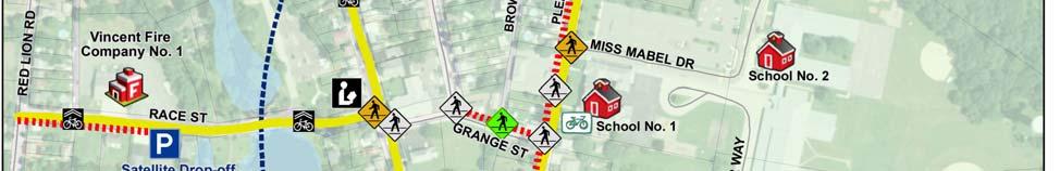
14 travel corridor for student travel and general traffic. For the purpose of student safety, a crossing guard is located at the intersection of Race Street and Main Street. Students traveling to School 3 living on the south side of Main Street, west of Pleasant Street, should use the crosswalk at Pleasant Street and Main Street to then head southeast toward Warrior Way. As mentioned in the School Description, the Burlington County Engineers Office has a resurfacing project planned for the summer of ADA compliant curb ramps will be installed or reinstalled along Main Street where sidewalks currently exist. Transportation Concerns: Figure 5: Intersection of Main Street and Mill Superintendent Michael Harris has expressed Street interest in the construction of sidewalks from Main Street and Warrior Way to and along Hilliards Bridge Road. There are no sidewalks on the north or south side of Main Street east of Warrior Way or south along Hilliards Bridge Road. During field audits, visibility issues were observed along Main Street at Mill Street and Race Street, shown in Figure 5. A total of 7 crashes occurred within the past 5 years at this location. Speeding was observed during field audits. Grange Street Grange Street is a local, low volume east west residential street extending from Main Street to Pleasant Street. The posted speed limit is 25 MPH. The western end of Grange Street connects to Main Street and the eastern end connects to Pleasant Street. At both ends, crosswalks exist and crossing guards are posted at student arrival and dismissal times. The SRTS Team noted that Grange Street is used as a cut through from Pleasant Street for traffic leaving the school campus at student dismissal times. Figure 6: Grange Street Transportation Concerns: Sidewalk coverage is missing from Plum Street to Pleasant Street along Grange Street, as shown in Figure 6, which forces children into the roadway that chose to walk or bike to school. Crossings at Browns Alley are not marked. This is a mandatory crossing for students traveling on Grange Street. Cross County Connection TMA 10


15 Pleasant Street Pleasant Street is a main corridor used by students traveling to School 1 or School 2. The street runs perpendicular to Main Street and continues past Grange Street before turning into Church Street. School 1 students may access the school off Pleasant Street, while School 2 students may access the school by turning off of Pleasant Street to Miss Mabel Drive. A crosswalk exists at the intersection of Grange Street where a crossing guard is stationed during student arrival and dismissal times. A second faded crosswalk is located in front of School 1 from the School 1 parking lot located on the west side of the roadway. School faculty stated that students living along Browns Alley cut through this parking lot. Vehicular traffic is prohibited from traveling north of Miss Mabel Drive on Pleasant Street, as shown in Figure 7. Parking is also prohibited in front of School 1 at Miss Mabel Drive. Transportation Concerns: Sidewalks are nonexistent along the west side of Pleasant Street from Main Street to Church Street, shown in Figure 8. A school crossing guard expressed some concern about speeding vehicles leaving Miss Mabel Drive. Students using the crosswalk at the School 1 parking lot are not guided by a crossing guard and proper pedestrian facilities are nonexistent, including ADA compliant curb ramps and sidewalks to guide student travel, shown in Figure 9. Figure 7: Pleasant Street, in front of School 1 at Miss Mabel Drive Figure 8: No sidewalks along westside of Pleasant Street At student arrival and dismissal times, vehicle conflict was observed at the intersection of Miss Mabel Drive and Pleasant Street, shown in Figure 10. Miss Mabel Drive serves as the only entrance and exit to School 2. Students leaving Schools 1 or 2 that have to travel north on Pleasant Street must cross Miss Mabel Drive. Cross County Connection TMA 11


16 Figure 9: Crosswalk in front of School 1 Figure 10: Entrance to Miss Mabel Drive Other Safety/Connectivity Concerns Browns Ally This is currently an unpaved roadway where vehicle and pedestrian traffic was observed during travel audits. Hilliards Bridge Road The Superintendent noted that he would like for the municipality to explore opportunities for the installation of pedestrian facilities from Main Street and Warrior Way to and along Hilliards Bridge Road. Church Street Currently, there is a lack of sidewalk connectivity along Church Street. Although it is not a primary travel corridor, the safety of children using the route would be improved by the installation of sidewalks where needed. Flooding Issues Kevin Greene, Supervisor of Buildings and Grounds, noted that during torrential rainfall, flooding occurs along Main Street approaching Mill Street from Route 206. Cross County Connection TMA 12
17 III. ACTIONS: 5 Es The following are the actions and recommendations suggested to achieve the goals listed in the Introduction by addressing the 5 E s of Safe Routes to School: Education, Encouragement, Enforcement, Engineering, and Evaluation. Education Education efforts are an important component in developing a sustainable Safe Routes to School Program and to relieve pedestrian and bicycle travel issues. These actions can help change community perceptions about how children should travel to and from school safely. They will also ensure that children receive proper instruction on walking and bicycling while raising community awareness of the benefits of walking and biking. Table 4 details the recommended Education Actions. Table 4: Education Actions Table 2: Education Actions Education Actions Responsibility Time Frame Creation and distribution of education materials to students, parents/guardians and community members Southampton Township School District/Cross County Connection TMA /NJSRTS Program Annually In class education on safe walking and bicycling practices, along with their health and environmental benefits Inclusion of SRTS elements in Teacher and Student Handbooks Southampton Township School District/Cross County Connection TMA Southampton Township School District Annually Annually Participate in New Jersey s Southampton Township Ongoing SRTS Webinar Program School District Social Media Account Southampton Township School District Ongoing Education Actions Responsibility Time Frame Cross County Connection and the Alan M. Voorhees Transportation Center will provide safety education and outreach materials for distribution to students, parents and school staff. These materials may be circulated at parent teacher meetings, school walking events, in class, or included with municipal information. Pedestrian and bicycling safety education should also be addressed at parent teacher meetings. Inclusion of parents in educational programming is a good way to reinforce safety education at home. Cross County Connection TMA 13
18 The school district should take advantage of Cross County Connection s 1 st, 2 nd and 3 rd Grade Pedestrian Program on an annual basis. Through active participation, students will learn about the benefits of walking, ways to avoid potential hazards while walking, how to properly understand and obey pedestrian signals, cross roadways safely, and understand traffic flow. New Jersey Core Curriculum Standards Cumulative Progress Indicators are covered in this program. Many schools in southern New Jersey use the Pedestrian Program as a building point for their SRTS programs. After the pedestrian lesson is administered, it is followed by an encouragement activity, such as a walk to school day. This method builds the excitement of students by preparing them to participate as safe and knowledgeable pedestrians. Social media accounts on Facebook can be created to solicit input from the community, as well as to disseminate information and request volunteers for encouragement activities. An account can also be created to gather data. Encouragement Encouragement actions promote walking and biking to school through programs such as walking school buses, satellite walking events, a Golden Sneaker Award, and other activities that generate excitement about walking and biking. These programs are essential to building the momentum necessary to significantly change school travel habits. Table 5: Encouragement Actions Table 2: Education Actions Encouragement Actions Responsibility Time Frame Satellite Drop Off Southampton Township Ongoing Program/Walking School Bus School District /Cross County Connection TMA Bicycle Rodeo Southampton Township School Year School District /Cross County Connection TMA Participation in International Southampton Township Annual in October Walk to School Day School District Participation in International Southampton Township Annual in May Bike to School Day Golden Sneaker Award Pilot School District Southampton Township School District School Year, Monthly Currently, the Southampton School District organizes a Satellite Drop off Program that operates much like a Walking School Bus. On specific days and/or weeks, students are asked to meet school faculty at the Vincentown Fire Hall where the group then walks to the district campus. While these events have occurred regularly in October in celebration of International Walk to School Day and again in the spring, it is suggested that the district expand the program as a Cross County Connection TMA 14

19 year round activity. This can be done at the discretion of the SRTS Team either as a monthly or quarterly occurrence. Bicycle rodeos are another strategy used to teach a large group of schoolchildren safe bicycling practices, such as how to check tire pressure, brakes and bike chains, fit a helmet, signal for turns, and come to quick stops. Cross County Connection can assist in the coordination of a bicycle rodeo on school grounds. To further promote bicycling and walking, each school should continue to participate in International Walk to School Day and organize International Bike to School Day events, which are held in the months of October and May, respectively. School events may be registered online by visiting International Walk to School Day can act as the official kick off to their SRTS Programs, annually. A Golden Sneaker Award Program is an incentivized contest that can be run in various ways. Some schools tally each student that walks or bikes to school daily, and at the end of each month the homeroom with the most walking students will earn the Golden Sneaker. A Golden Sneaker Award, like the one shown in Figure 11, can be created by spray painting an old running shoe gold and mounting it on top of a trophy stand. Incentive programs are a good way to keep the momentum going with SRTS programs. Figure 11: Golden Sneaker Award Enforcement Enforcement of safe and lawful travel behavior around schools, on primary travel corridors and throughout the town is important to ensuring a safe walking and biking environment for children. The New Jersey State Police do not currently work with the school district, but do patrol areas around the district campus. Table 6: Enforcement Actions Table 2: Education Actions Enforcement Actions Responsibility Time Frame Speed Enforcement New Jersey State Police Ongoing Stop for pedestrians in New Jersey State Police Ongoing crosswalks enforcement Vegetation maintenance enforcement on sidewalks Public Works Ongoing Main Street and Pleasant Street should be targeted for enforcement due to concerns about speeding on these corridors. In addition to existing efforts, participation in New Jersey s Cross County Connection TMA 15
20 Pedestrian Decoy Safety Program 3 should be considered. This program has been a successful enforcement tool in many New Jersey communities to ensure that vehicles stop for pedestrians in crosswalks and obey New Jersey s Stop and Stay Stopped law (NJ 39:4 36). While performing field audits, it was noticed that Race Street had sidewalks obstructed by vegetation. Maintenance at these locations is important so as not to impede pedestrian activity, thus forcing students into the street. Well maintained vegetation also improves the aesthetic quality of the pedestrian environment, improves visibility, and improves the comfort level of the sidewalk user. Maintenance responsibilities will be subject to the ownership of adjacent parcels. However, the school district and local government should educate residents about this problem and encourage them to maintain their properties. Engineering Engineering recommendations in this Travel Plan, are discussed in Chapter IV and shown on Map 3. These recommendations focus on safety improvements in primary school travel corridors that can be implemented in a short timeframe. These recommendations are general in nature and are subject to American Association of State Highway and Transportation Officials (AASHTO) and Manual on Uniform Traffic Control Devices (MUTCD) regulations and guidelines. Burlington County has plans in place for pedestrian improvements along Main Street, but there are additional locations in need of improvement that may be addressed without high cost brick and mortar projects. Evaluation Determining participation in walking and biking programs, how many children walk and bike to school, and parent concerns is an important part of a SRTS program. Evaluating these factors allows school staff to determine the success of their SRTS activities and how they might best prioritize and modify their efforts to encourage more children to walk and bike to school. Table 7: Evaluation Actions Evaluation Action Responsibility Time Frame Student Travel Tally Southampton Township School District School Year; Quarterly Parent Survey Southampton Township School District /Cross County Connection TMA / Voorhees Transportation Center School Year; Annually 3 Cops in Crosswalks: Pedestrian Decoy Enforcement in New Jersey, Pedestrian and Bicycle Information Center, Accessed on 3/25/2014, Cross County Connection TMA 16
21 School staff should conduct student tallies and/or parent surveys to measure the number of children walking and bicycling. Student tallies are held in class by school staff to determine how children arrived at school that day. Tallies should be held at regular intervals to determine the impact of SRTS activities in student travel choices. Tallies should also be compared yearly to measure annual success. Parent surveys may be sent home with children or distributed to parents electronically to determine parent attitudes and concerns about children walking or biking to school. Survey results may be submitted to the Voorhees Transportation Center for compilation and reporting. Cross County Connection TMA will assist schools in assessing results and coordinating follow up activities, if desired. Additional information on evaluation methods is available at the New Jersey Safe Routes to School website: progress/ Cross County Connection TMA 17

22 IV.RECOMMENDATIONS Based on the findings of this Travel Plan and discussions with the Working Group, the following improvements are recommended to accommodate and encourage safe bicycling and walking at the Southampton school. These recommendations are shown on Map 3, page 21. Bicycle Accommodations Shared lane pavement markings, or sharrows, designate a roadway as a shared travel environment for bicycles and automobiles. These markings, seen in Figure 12, alert motorists to expect and share the road with cyclists and also show bicyclists where to ride. Share the Road (W16 1P) signage may be used in combination with sharrows. Guidance on shared lane marking installation is found in Section 9C.07 of the Manual on Uniform Traffic Control Devices (MUTCD). Based upon guidelines set forth by the National Association of City Transportation Officials (NACTO) and the American Association of State Highway and Transportation Officials (AASHTO), it is recommended to consult an engineer about the installation of sharrow pavement markings and Share the Road signs on the following roadways: Race Street (Red Lion Road to Main Street) Main Street (Church Street to Hilliards Bridge Road) Pleasant Street (Main Street to Church Street) Church Street (Main Street to Pleasant Street) Crosswalk Markings Currently, there are some crosswalks missing on primary school travel corridors. High visibility marked crosswalks are important in locations with significant pedestrian traffic because it both alerts motorists to the presence of a crosswalk and designates proper crossing locations to pedestrians. It is recommended that an engineer be consulted regarding the installation of appropriate crosswalk markings at: Grange Street and Browns Alley Church Street and Browns Alley Recommended repainting of appropriate crosswalk markings at: Main Street and Church street Main Street and Grange Street Main Street and Pleasant Street Grange Street and Plum Street Grange and Pleasant Street Figure 12: Sharrow Cross County Connection TMA 18


23 Church Street and Plum Street Pleasant St. and the entrance to School 1 Consider installation of higher visibility zebra, ladder, or continental crosswalk markings, shown in Figure 13, instead of the existing double line marking to delineate heavily used crosswalks on primary travel corridors. These higher visibility crossings have been shown to reduce vehicle pedestrian conflicts. 4 Figure 13: Crosswalk Treatments Missing Curb Ramps There are a number of non ADA compliant curb ramps at intersections and crosswalks in the study area. This creates a safety hazard for students with mobility impairments and impedes bicycle travel for younger students that ride on sidewalks. The Americans with Disabilities Act (ADA) requires state and local governments to follow specific standards at pedestrian crossings that dictate the width, slope and placement of curb ramps. ADA requirements also specify that curb ramps must be equipped with detectable warning surfaces that provide detectable warning to visually impaired pedestrians. The ADA rules and requirements vary depending on whether the roadway was constructed Pre ADA 1992 or earlier or, Post ADA 1993 to present. 4 Cross County Connection recommends consulting with an engineer or other qualified professional familiar with ADA requirements when exploring options to improve pedestrian safety in the study area. Traffic Control Speeding along Main Street was a concern mentioned by school district faculty. The County Engineer has stated that pedestrian beacons with dynamic speed limit signs could be installed to slow vehicle traffic and alert motorist of pedestrian travel. Speed humps, such as the one shown in Figure 14, are also an option proposed by the County Engineer. Figure 14: Speed Hump Recommended installation of pedestrian beacon or speed humps with concurrence from the County Engineer at: Main Street to the north and the south of Warrior Way 4 For more information on the Specific Requirements for local governments under the Americans with Disabilities Act please visit ADA Best Practices Tool Kit for State and Local Governments at Cross County Connection TMA 19

24 Wayfinding Signage Wayfinding signage and markings provide direction to students and parents and mark roads as preferred travel routes. Wayfinding could include paint markings designating preferred corridors by color or markers, such as the one pictured in figure 15 that designate safe travel routes. These markings and signs also increase visibility of walking routes among the community and encourage more children to walk or bike to school. This plan recommends consideration of additional wayfinding markings or signage to be placed on primary school travel corridors. Figure 15: SRTS Route Marker Missing Sidewalks While the majority of primary school travel corridors have continuous sidewalk coverage on at least one side of the street, there are several locations with gaps in the network. Recommended installation of sidewalks on: South side of Race Street from Red Lion Road to Vincentown Fire Hall parking lot North Side of Grange Street from Plum Street to Pleasant Street West side of Pleasant Street from Main Street to Church Street In addition to the above locations, installation of sidewalks on Church Street is recommended to accommodate students, as there is very little sidewalk coverage currently installed on Church Street. The Superintendent expressed interest in extending sidewalk coverage on Main Street from the intersection of Main Street and Warrior Way to and along Hilliards Bridge Road, as well. Because of the one way bridge along Hilliard Bridge Road, sidewalk coverage may not be feasible along the entire stretch of the roadway. Intersections: Visibility/Safety During walking audits, obstruction of crosswalks by motorists was observed at the intersection of Main Street and Mill Street. From , there were seven vehicle crashes at or near this intersection. The County Engineer recommends that the issue be addressed by Southampton Township with an ordinance to prohibit stopping or standing along the westerly curbline of Main Street from the southerly curbline of Mill Street to a point 75 feet south, therefrom. Once the ordinance is adopted, it should be forwarded to the County Engineer s Office for the preparation of a concurrent resolution. When the resolution is passed, the township can install proper signage in accordance with Burlington County s Standards. It is recommended that parking ordinances be reviewed at: Main Street and Mill Street At School 2, during student arrival and dismissal times, vehicle conflict occurs between parents and buses dropping off and picking up students, respectively, at the following intersection: Miss Mabel Drive and Pleasant Street. Cross County Connection TMA 20
25 The County Engineer recommends separating parents/guardians dropping off and picking up their children from bus traffic. This can be accomplished by requiring all parents/guardians from both School 2 and School 3 to drop off and pick up students along Miss Mabel Drive and loop through the parking lot back to Pleasant Street. All buses transporting students to School 1, School 2 and School 3 can be required to use Warrior Way, thus segregating modes of travel. Parents that drive students to School 1 generally use the parking lot directly across from the school; therefore do not add to the congestion at the intersection of Miss Mabel Drive and Pleasant Street. Another option to fix the safety issue at Miss Mabel Drive and Pleasant Street would be to relocate the Miss Mabel Drive egress to the one way section of Pleasant Street. This was suggested by Consulting Engineer Frank Morris. Cross County Connection TMA 21


26 Map 3: Study Area Recommended Improvements Cross County Connection TMA 22
27 Project Funding Implementation of engineering improvements can be expensive. Fortunately, there are funding programs at the state and federal level dedicated to assist with the implementation of projects that would improve the safety of Southampton students walking and biking to school. These funding programs are competitive, have deadlines and the application process requires time to complete. In addition, the programs listed below receive far more funding requests than can be obligated. Cross County Connection is available to provide assistance in determining appropriate funding sources and preparing grant applications. The funding programs listed below are provided as a general guide, and are not an exhaustive list of available funding sources. For more information on a specific program, please contact the granting agency or refer to the grant program guidelines found on the program websites. Safe Routes to School (SRTS) Infrastructure Program Federal funding is available for SRTS projects that improve the safety of children walking or biking to school. The program is administered through NJDOT. Eligible projects may include the planning, design, construction or installation of sidewalks, crosswalks, signals, traffic calming and bicycle facilities within two miles of an elementary or middle school (K 8). Local and regional governments, school districts and individual schools are eligible to be project sponsors and receive direct funding. Transportation Alternatives Program (TAP) TAP is a federal funding program administered through NJDOT. The program is designed to foster more livable communities and promote alternative modes of transportation such as biking and walking. Eligible activities include bikeway construction, acquisition of right of way for bikeways and many other projects. Activities funded by TAP were previously funded by the Transportation Enhancements (TE) Program contained in previous federal transportation bills. A key addition to the TAP program in the current federal transportation bill (MAP 21) is the funding eligibility for projects dedicated to the construction, planning and design of infrastructure projects that provide safe routes for non drivers which includes children, seniors and disabled persons. NJDOT is providing the 20% match required under the new MAP 21 legislation. Eligible project sponsors for TAP funds include local and regional governments, transit agencies, school districts and individual schools. Municipal Aid Program Municipal Aid is a state funded program administered by NJDOT for roadway and bridge improvements, including bicycle and pedestrian projects. Each county is appropriated funds for their constituent municipalities based on a formula. Municipalities must submit applications, detailing a potential project, to their local NJDOT District Office. Projects awarded funds in 2012 included construction of bicycle lanes and pedestrian safety improvements. Cross County Connection TMA 23
28 School districts and individual schools are not eligible to apply for these funds directly, but should encourage their municipal government to apply for these funds and direct them towards improving the bicycle and pedestrian safety around their schools. For more information regarding these three funding programs contact: New Jersey Department of Transportation (NJDOT) Website: District Manager, NJDOT 1 Executive Campus Route 70 West, 3 rd Floor Cherry Hill, NJ Phone: Fax: Conclusion Southampton Township School District is committed to increasing the number of children that walk and bike to school through safety improvements and programs that educate and encourage biking and walking. The municipality and school district currently address child walking safety by providing crossing guards at busy crossings. This Travel Plan was undertaken to address the school district s interest in improving walking and biking programs, and its continued concerns about existing and potential safety issues due to speeding, road crossings, and walking and biking infrastructure gaps in the community it serves. The Plan outlines several education and encouragement programs that the school district is either actively pursuing or has expressed interest. Infrastructure improvements such as crosswalk installation/signage, bikeways and shared road treatments were recommended on the priority travel corridors of Race Street, Main Street, and Pleasant Street. Implementation of this Plan and the sustained success of any effort to increase walking and biking to school will require continued partnership among local and regional organizations. Infrastructure improvements must be employed alongside hands on education and encouragement programs to maintain momentum towards achieving the goals set forth by the SRTS Team. The Southampton School District and the municipality have demonstrated through past successes and current efforts that they are committed to creating a community that fosters active and healthy children, as well as providing a safe environment for walking and biking. Cross County Connection TMA 24
Chapter 2. Bellingham Bicycle Master Plan Chapter 2: Policies and Actions
 Chapter 2 Bellingham Bicycle Master Plan Chapter 2: Policies and Actions Chapter 2: Policies and Actions The Bicycle Master Plan provides a road map for making bicycling in Bellingham a viable transportation
About the Studio. Edward J. Bloustein School of Planning and Public Policy - Rutgers University
 About the Studio Edward J. Bloustein School of Planning and Public Policy - Rutgers University Purpose of studio: Help City of Bayonne apply for Safe Routes to School (SRTS) funding by producing a School
CONNECTING PEOPLE TO PLACES
 CONNECTING PEOPLE TO PLACES 82 EAST BENCH MASTER PLAN 07 Introduction The East Bench transportation system is a collection of slow moving, treelined residential streets and major arteries that are the
City of Vineland Safe Routes to School Travel Plan
 April 1, 2014 2014 City of Vineland Safe Routes to School Travel Plan Gloria M. Sabater Elementary School 4/1/2014 Contents Introduction 1 School Description 1 Existing Policies and Practices 2 Walk/Bike
APPENDIX A: Complete Streets Checklist DRAFT NOVEMBER 2016
 APPENDIX A: Complete Streets Checklist DRAFT NOVEMBER 2016 Complete Streets Checklist MetroPlan Orlando s Complete Streets Checklist is an internal planning tool for staff to further implementation of
Margate City School District School Travel Plan
 Margate City School District School Travel Plan Prepared by: Cross County Connection Transportation Management Association June 2015 Cross County Connection Transportation Management Association was formally
Hedgepeth Williams Middle School and Paul Robeson Elementary School Trenton, NJ. School Travel Plan
 Hedgepeth Williams Middle School and Paul Robeson Elementary School Trenton, NJ School Travel Plan Hedgepeth Williams Middle School Description: Hedgepeth-Williams Middle School is located at 301 Gladstone
NJDOT Complete Streets Checklist
 Background The New Jersey Department of Transportation s Complete Streets Policy promotes a comprehensive, integrated, connected multi-modal network by providing connections to bicycling and walking trip
Broad Street Bicycle Boulevard Design Guidelines
 Broad Street Bicycle Boulevard Design Guidelines Building from the strategies introduced in the 2013 Bicycle Transportation Plan and community input received thus far, City Transportation Staff have identified
TOWN OF PORTLAND, CONNECTICUT COMPLETE STREETS POLICY
 TOWN OF PORTLAND, CONNECTICUT COMPLETE STREETS POLICY I. VISION, GOALS & PRINCIPLES VISION To improve the streets of Portland making them safer and more accessible for all users including pedestrians,
July 5, Arthur R. Ware, Jr. Elementary School 2017 Safe Routes to School Walkabout Report
 July 5, 2017 Arthur R. Ware, Jr. Elementary School 2017 Safe Routes to School Walkabout Report 1 Walkabout Report Introduction On April 28, 2017, City, School, and SAWMPO staff met to conduct a Safe Routes
Introduction.
 2307-1.0. Introduction. Delaware s Safe Routes to School (SRTS) Program was established September 10, 2002 when Governor Ruth Ann Minner signed Senate Bill 353 of the 141st General Assembly of Delaware
BIKE PLAN CONTENTS GATEWAY
 CONTENTS Acknowledgments...vii Great Rivers Greenway District Board of Directors... vii Great Rivers Greenway District Staff... vii Project Consultants... vii Committees... viii Citizens Advisory Committee
REGIONAL BICYCLE AND PEDESTRIAN DESIGN GUIDELINES
 REGIONAL BICYCLE AND PEDESTRIAN DESIGN GUIDELINES November 16, 2011 Deb Humphreys North Central Texas Council of Governments Bicycle and Pedestrian Advisory Committee Snapshot of the Guide 1. Introduction
ACTIVE TRANSPORTATION
 ACTIVE TRANSPORTATION Mobility 2040 Supported Goals Improve the availability of transportation options for people and goods. Support travel efficiency measures and system enhancements targeted at congestion
Traffic Circulation & Pedestrian Safety Study
 Lyons Township High School North Campus La Grange, Illinois Parking Lot Vaughan Building N Main Building Prepared for: Prepared by: July 23, 2015 Contents List of Figures, iii 1. Introduction...1 2. Existing
TRAFFIC CALMING POLICY NEWTOWN TOWNSHIP DELAWARE COUNTY, PA
 TRAFFIC CALMING POLICY NEWTOWN TOWNSHIP DELAWARE COUNTY, PA September 2014 1 TABLE OF CONTENTS INTRODUCTION... 3 PURPOSE AND GOALS... 3 DEFINITIONS... 4 APPLICABILITY... 5 ELIGIBLE STREETS... 5 LOCATION
Bringing together community and health. Physical Activity and Nutrition Unit Office of Statewide Health Improvement Initiatives
 Bringing together community and health. Physical Activity and Nutrition Unit Office of Statewide Health Improvement Initiatives Physical Activity and Nutrition Unit Office of Statewide Health Improvement
Bicycle Master Plan Goals, Strategies, and Policies
 Bicycle Master Plan Goals, Strategies, and Policies Mobilizing 5 This chapter outlines the overarching goals, action statements, and action items Long Beach will take in order to achieve its vision of
Safe Routes to School Action Plan Aberdeen, Idaho
 Background Aberdeen, Idaho is a largely agricultural community of nearly 2,000 people and is located in the southeast portion of the state on the western edge of American Falls Reservoir. The community
East Burke Transportation, Safety and Capacity Improvements
 East Burke Transportation, Safety and Capacity Improvements The purpose of this project is to increase mobility and improve safety for pedestrians, cyclists, and motor vehicles along VT Route 114 in the
City of Novi Non-Motorized Master Plan 2011 Executive Summary
 City of Novi Non-Motorized Master Plan 2011 Executive Summary Prepared by: February 28, 2011 Why Plan? Encouraging healthy, active lifestyles through pathway and sidewalk connectivity has been a focus
Non-Motorized Transportation 7-1
 Non-Motorized Transportation 7-1 Transportation facilities no longer mean just accommodating a vehicle powered by a combustion engine. Pedestrian and non-motorized facilities are important modes of travel
CITY OF COCOA BEACH 2025 COMPREHENSIVE PLAN. Section VIII Mobility Element Goals, Objectives, and Policies
 CITY OF COCOA BEACH 2025 COMPREHENSIVE PLAN Section VIII Mobility Element Goals, Objectives, and Policies Adopted August 6, 2015 by Ordinance No. 1591 VIII MOBILITY ELEMENT Table of Contents Page Number
CITY OF OAK CREEK SAFE ROUTES TO SCHOOL ACTION PLAN. East Middle School
 CITY OF OAK CREEK SAFE ROUTES TO SCHOOL ACTION PLAN East Middle School CITY OF OAK CREEK SAFE ROUTES TO SCHOOL ACTION PLAN East Middle School Why Safe Routes to School? Safe Routes to School ( SRTS ) is
Watertown Complete Streets Prioritization Plan. Public Meeting #1 December 14, 2017
 Watertown Complete Streets Prioritization Plan Public Meeting #1 December 14, 2017 Goals for Public Meeting Overview of MassDOT Complete Streets Funding Program Educate the community on Complete Streets
Safe Routes to School Comprehensive Plan
 Safe Routes to School Comprehensive Plan City of Apple Valley Dakota County, MN May 2010 Prepared by: Project Background The Statewide Health Improvement Program (SHIP) aims to help Minnesotans live longer,
SAFE ROUTES TO SCHOOL
 SAFE ROUTES TO SCHOOL Edgewood Elementary School Existing Conditions and ACTION PLAN > Oak Creek - Franklin Joint School District Table of Contents CONTEXT Enrollment Boundaries Enrollment
PEDESTRIAN ACTION PLAN
 ATTACHMENT 2 CITY OF SANTA MONICA PEDESTRIAN ACTION PLAN CITY OF SANTA MONICA PEDESTRIAN ACTION PLAN This page intentionally left blank EXECUTIVE SUMMARY CHAPTER 1 EXECUTIVE SUMMARY Setting the Stage
BICYCLE FACILITIES INVENTORY: SUMMARY REPORT
 BICYCLE FACILITIES INVENTORY: SUMMARY REPORT Southern New Jersey September 2008 2002 D Lincoln Drive West Marlton, NJ 08053 (856) 596-8228 www.driveless.com BICYCLE FACILITIES INVENTORY SUMMARY REPORT
C/CAG. Sunnybrae Elementary School Walking and Bicycling Audit. San Mateo-Foster City School District JUNE 2013
 Sunnybrae Elementary School Walking and Bicycling Audit JUNE 2013 San Mateo-Foster City School District C/CAG City/County Association of Governments of San Mateo County SUNNYBRAE ELEMENTARY SCHOOL WALKING
Monument Elementary School Trenton, NJ School Travel Plan
 Monument Elementary School Trenton, NJ School Travel Plan Prepared by Greater Mercer TMA With Assistance from Alan M. Voorhees Transportation Center; Rutgers, The State University of New Jersey and NJ
Chapter 5. Complete Streets and Walkable Communities.
 Chapter 5. Complete Streets and Walkable Communities. 5.1 Description of Complete Streets. Cities throughout the world, and specifically the United States, are coming to embrace a new transportation and
Agenda. Overview PRINCE GEORGE S PLAZA METRO AREA PEDESTRIAN PLAN
 PRINCE GEORGE S PLAZA METRO AREA PEDESTRIAN PLAN May 28, 2008 Agenda Welcome and introductions Project overview and issue identification Planning context and strengths Design challenges and initial recommendations
Morristown, NJ Complete Streets Policy
 Morristown, NJ Complete Streets Policy Introduction A Complete Street is defined as a means to provide safe access for all users by designing and operating a comprehensive, integrated, connected multi-modal
ROUNDABOUTS/TRAFFIC CIRCLES
 GENERAL 1. Description This standard identifies minimum requirements that shall be met for Roundabouts and Neighborhood Traffic Circles in the design and construction of elements for Arlington County Horizontal
Vallecito Elementary School. Travel Plan
 Vallecito Elementary School Travel Plan TABLE OF CONTENTS 1. PURPOSE... 1 1.1. SR2S PLANNING, IMPLEMENTATION AND MONITORING... 1 1.2. MARIN COUNTY MEASURE A... 1 2. VALLECITO ELEMENTARY SCHOOL PROFILE...
VILLAGE OF NILES TRAFFIC CALMING POLICY
 INTRODUCTION There is increasing interest across the country in developing new strategies to reduce the speed and amount of traffic in residential neighborhoods. Measurement of speeds, traffic volumes,
Proposed. City of Grand Junction Complete Streets Policy. Exhibit 10
 Proposed City of Grand Junction Complete Streets Policy Exhibit 10 1 City of Grand Junction Complete Streets Policy Vision: The Complete Streets Vision is to develop a safe, efficient, and reliable travel
Solana Beach Comprehensive Active Transportation Strategy (CATS)
") Solana Beach Comprehensive Active Transportation Strategy (CATS) 3.0 Goals & Policies The Solana Beach CATS goals and objectives outlined below were largely drawn from the Solana Beach Circulation Element
Solana Beach Comprehensive Active Transportation Strategy (CATS) 3.0 Goals & Policies The Solana Beach CATS goals and objectives outlined below were largely drawn from the Solana Beach Circulation Element
Arlington Public Schools Thomas Jefferson Site Evaluation Transportation Networks. Thomas Jefferson Working Group Meeting #6 November 10, 2014
 Arlington Public Schools Thomas Jefferson Site Evaluation Transportation Networks Thomas Jefferson Working Group Meeting #6 November 10, 2014 2 3 INTRODUCTION 4 Goal of our work: Identify and assess multi-modal
City of Elizabeth City Neighborhood Traffic Calming Policy and Guidelines
 City of Elizabeth City Neighborhood Traffic Calming Policy and Guidelines I. Purpose: The City of Elizabeth City is committed to ensure the overall safety and livability of residential neighborhoods. One
MONTCLAIR SAFE COMPLETE STREETS IMPLEMENTATION PLAN. Monday November 13, 2017 Michael Dannemiller, Principal Engineer NV5, Inc.
 MONTCLAIR SAFE COMPLETE STREETS IMPLEMENTATION PLAN Monday November 13, 2017 Michael Dannemiller, Principal Engineer NV5, Inc. PROJECT TEAM THE OFFICE OF BICYCLE AND PEDESTRIAN PROGRAMS, NEW JERSEY DEPARTMENT
Double the amount of bicycle ridership while at the same time reducing the number of bicycle crashes by one-third.
 CHAPTER 6 Recommended Policies and Action Items To achieve the goals stated in Chapter 1 and guide implementation of the Bicycle Plan, policies and action items have been identified. They are presented
SAFE ROUTES TO SCHOOL
 SAFE ROUTES TO SCHOOL Forest Ridge Elementary School Existing Conditions and ACTION PLAN > Oak Creek - Franklin Joint School District Table of Contents CONTEXT Enrollment Boundaries
City of San Diego Vision Zero Draft Strategic Plan FY 2017
 City of San Diego Vision Zero Draft Strategic Plan FY 2017 Engineering Objective: To develop and implement a strategy that employs best planning, design and engineering practices. Background: Over the
4 Goals, Objectives & Actions
 Chapter4 4 This chapter presents goals, objectives, and recommended actions to support the vision of making Overland Park a safer and easier place to ride a bicycle. 35 4.1 Recommendations Structure The
Off-road Trails. Guidance
 Off-road Trails Off-road trails are shared use paths located on an independent alignment that provide two-way travel for people walking, bicycling, and other non-motorized users. Trails specifically along
Borough of Danville, PA Traffic Calming Program Guidelines
 Borough of Danville, PA Traffic Calming Program Guidelines Adopted by Borough Council on 1 INTRODUCTION Speeding Traffic is a major concern in the Borough of Danville because of its detrimental impacts
EXECUTIVE SUMMARY. Vision
 Vision Walking and bicycling in Salt Lake City will be safe, convenient, comfortable, and viable transportation options that connect people to places, foster recreational and economic development opportunities,
WHEREAS, the New Jersey Department of Transportation' s Complete Streets
 WHEREAS, the State Department of Transportation adopted a Complete Streets Policy ( Policy No. 703), effective December 3, 2009, for all projects funded through the Department' s Capital Program and strongly
NM-POLICY 1: Improve service levels, participation, and options for non-motorized transportation modes throughout the County.
 Transportation PRINCE WILLIAM COUNTY 2008 COMPREHENSIVE PLAN NON-MOTORIZED PLAN CONTENTS Goals, Policies, and Action Strategies Table 4 (Bike Facility Classifications and Descriptions) Table 5 (Bike Facility
2 Mark Twain Elementary School Report
 2 Mark Twain Elementary School Report Principal: Greg Kaatz Grades: K-2 Enrollment: 323 Address: 425 N. Church Street First bell: 8:10 a.m. Silverton, OR 97381 Last bell: 2:30 p.m. Free & Reduced Lunch:
SRTS IMPLEMENTATION COSTS
 SRTS IMPLEMENTATION COSTS What Is a Estimate? A cost estimate establishes the anticipated budget required to implement the actions (the improvement projects and programs) identified in your School Travel
CHAPTER 3: Vision Statement and Goals
 Davidson Walks & Rolls: Active Transportation Master Plan CHAPTER 3 Contents: Overview Vision Statement Measurable Goals Public Outreach CHAPTER 3: Vision Statement and Goals Overview The vision statement
Public Information Centre
 WELCOME Public Information Centre Father Tobin Road Lougheed Middle School - Library Wednesday November 7, 2012 7:00 p.m.to 9:00 p.m. Please sign in Neighbourhood Traffic Calming Guide Background The City
OLDER PEDESTRIANS AT RISK
 OLDER PEDESTRIANS AT RISK A TEN-YEAR SURVEY AND A LOOK AHEAD August 0 The population of older adults is growing in the U.S. and in the tri-state region. According to AARP, one in three Americans is now
CROSSING GUARD PLACEMENT CONSIDERATIONS AND GAP ASSESSMENT
 CROSSING GUARD PLACEMENT CONSIDERATIONS AND GAP ASSESSMENT Many factors contribute to the need for a Crossing Guard. General federal guidance, provided by the FHWA MUTCD, states that adult crossing guards
INDOT Complete Streets Guideline & Policy
 INDOT Complete Streets Guideline & Policy INTRODUCTION The Complete Streets guidelines build upon multiple efforts and promote a multimodal transportation system that is integrated and sustains land use
Regional School District #19 Transportation Policy
 Regional School District #19 Transportation Policy I. Scope of Policy Many students attending E.O. Smith High School are transported by local boards of education, through written agreements with those
City of Gainesville Transportation/Roadway Needs PROJECT SUMMARY
 A1 Roadway Resurfacing $23,846,000 TYPE: Preservation of existing system Roadway resurfacing A2 Signal Replacement $6,000,000 TYPE: Preservation of existing system Replace traffic signals. B1 W 6th St
SCHOOL CROSSING PROTECTION CRITERIA
 CITY OF MADISON TRAFFIC ENGINEERING SCHOOL CROSSING PROTECTION CRITERIA January 2016 Adopted as Policy on August 31, 1976, by Common Council by Amended Resolution #29,540 Amended on September 14, 1976,
Chapter 7. Transportation. Transportation Road Network Plan Transit Cyclists Pedestrians Multi-Use and Equestrian Trails
 Chapter 7 Transportation Transportation Road Network Plan Transit Cyclists Pedestrians Multi-Use and Equestrian Trails 7.1 TRANSPORTATION BACKGROUND The District of Maple Ridge faces a number of unique
5. RUNNINGWAY GUIDELINES
 5. RUNNINGWAY GUIDELINES These guidelines should be considered collectively when making runningway decisions. A runningway is the linear component of the transit system that forms the right-of-way reserved
WELCOME Public Information Centre
 WELCOME Public Information Centre Fernforest Drive Brampton Soccer Centre Community Room #2 Tuesday January 19, 2016 6:30 p.m.to 9:00 p.m. Please sign in Neighbourhood Traffic Calming Guide Background
MAG Town of Cave Creek Bike Study Task 6 Executive Summary and Regional Significance Report
 Page 1 MAG Town of Cave Creek Bike Study Task 6 Executive Summary and Regional Significance Report August 1, 2012 MAG Project #481 Page 2 Task 6 Executive Summary and Regional Significance Report Introduction
TOWN OF PAYSON TRAFFIC CALMING MANUAL
 TOWN OF PAYSON TRAFFIC CALMING MANUAL APPROVED BY THE PAYSON TOWN COUNCIL SEPTEMBER 6, 2007 TOWN OF PAYSON TRAFFIC CALMING POLICY 1.0 Introduction Traffic Calming involves retrofitting physical devices
Chapter 2: Standards for Access, Non-Motorized, and Transit
 Standards for Access, Non-Motorized, and Transit Chapter 2: Standards for Access, Non-Motorized, and Transit The Washtenaw County Access Management Plan was developed based on the analysis of existing
Proposed Bridge Street East Bicycle Lanes Public Open House Thursday, April 27, 2017
 WELCOME Proposed Bridge Street East Bicycle Lanes Public Open House Thursday, April 27, 2017 Purpose of the Open House The purpose of this Open House is to gain public input on the bicycle lanes proposed
Wellington Exempted Village School District SAFE ROUTES TO SCHOOL TRAVEL PLAN January 2014
 Wellington Exempted Village School District SAFE ROUTES TO SCHOOL TRAVEL PLAN January 2014 OHIO SAFE ROUTES TO SCHOOL WELLINGTON EXEMPTED VILLAGE SCHOOL DISTRICT TRAVEL PLAN SECTION 1: WELLINGTON EXEMPTED
Bikeway action plan. Bicycle Friendly Community Workshop March 5, 2007 Rochester, MN
 Bikeway action plan Summary The was held on March 5, 2007 at the Rochester Mayo Civic Center. The workshop was hosted by Rochester-Olmsted County Planning Department in collaboration with the League of
Windy Ridge Elementary School
 Windy Ridge Elementary School SCHOOL ROUTE PLAN For WINDY RIDGE ELEMENTARY SCHOOL LOCATION 54 ORANGE COUNTY Prepared for: ORANGE COUNTY SCHOOL ASSESSMENT PROGRAM ORANGE COUNTY PUBLIC WORKS Traffic Engineering
Appendix T CCMP TRAIL TRAFFIC & TRANSPORTATION DESIGN STANDARD
 Appendix T CCMP 3.3.4 TRAIL TRAFFIC & TRANSPORTATION DESIGN STANDARD 3.3.4 Trail Traffic and Transportation Design Multi-use trails have certain design standards, which vary depending on the agency that
CITY OF KASSON TRANSPORTATION ALTERNATIVES KASSON SAFE ROUTES TO SCHOOL
 ve ha 8t G B A Mantorville Ave N 240th Ave 16th St NE 11th Ave NE K-M HIGH SCHOOL SUNRISE TRAIL TO MANTORVILLE MNTH 57 SUNSET TRAIL TO MANTORVILLE NE PARK 16TH ST NE TRAIL K-M ELEMENTARY SCHOOL K-M MIDDLE
Chapter 6: Along the Street
 Chapter 6: Along the Street This section describes the types of infrastructure that should be in place along school routes to make walking and bicycling to school safer. Sidewalks In communities with sidewalks,
Madison Urban Area and Dane County. Bicycle Transportation Plan Summary. September Introduction. Bicycle Plan Scope and Planning Process
 Bicycle Transportation Plan Summary Madison Urban Area and Dane County Introduction September 2000 Bicycling is an important mode of transportation in the Madison urban area and countywide that is available
Safe Routes to School Guide
 Safe Routes to School Guide Steps to Creating a Safe Routes to School Program Created February 2007 SafeRoutes National Center for Safe Routes to School This guide was developed by the Pedestrian and Bicycle
Bicycle and Pedestrian Connectivity Study Phase 2
 Connectivity Study Phase 2 Process PROCESS OUTCOMES Phase Prepared By STEP I Public Participation and Outreach 1. RTP Outreach activities, and development of the Bike and Ped Task Force Phase 1 2011 OCPC
Tonight is for you. Learn everything you can. Share all your ideas.
 Strathcona Neighbourhood Renewal Draft Concept Design Tonight is for you. Learn everything you can. Share all your ideas. What is Neighbourhood Renewal? Creating a design with you for your neighbourhood.
General Design Factors
 Chapter 3: 3-1.0 Introduction General Design Factors Mn/DOT s goals include encouraging and accommodating safe bicycling. From a design perspective, these goals are achieved by first having an understanding
2. Vision & Goals. Vision. Santa Rosa is a community where walking and bicycling are comfortable and convenient for people of all ages and abilities.
 2. Vision & Goals Overview The goals of the Santa Rosa Bicycle and Pedestrian Master Plan Update reflect the priorities expressed by the community throughout the public outreach phase of this Plan Update.
Montclair s Complete Streets Experience
 Presented by: Hon. Jerry Fried, Mayor Montclair Township About Montclair Six square miles Six commuter rail stations Four local bus routes (NJ Transit) Two private commuter bus routes Five business districts
Walkabout Summary Report
 Walkabout Summary Report Introduction On September 3, 2014, stakeholders at Bessie Weller Elementary School (Bessie Weller ES) in Staunton, Virginia met to examine the walking and bicycling network around
Implementing the Three Es of School Zone Traffic Calming
 Implementing the Three Es of School Zone Traffic Calming Use this evaluation tool as a guide to analyze the specific safety needs of your school. SCHOOL PROFILE School Name: School District: Address: Phone
Closing Plenary Session
 TRAFFIC SAFETY CONFERENCE Closing Plenary Session June 9, 2017 Las Colinas, TX Order of Report Out June 9, 2017 Las Colinas, TX Distracted Driving Prioritized Countermeasures Countermeasure 4a Systemically
Bicycle and Pedestrian Connectivity Study. Old Colony Planning Council
 Bicycle and Pedestrian Connectivity Study Old Colony Planning Council Outline Why consider bike/peds in road designs? Why are measures needed? Connecting Land Use with Transportation Evaluation Tools:
DRAFT. Table of Contents. Background
 Douglas County Table of Contents Existing Infrastructure 86 Funding 89 Policy and Program Recommendations 90 Infrastructure Recommendations 92 Conclusion 95 Background Home to 4,500 residents and Baker
What Is a Complete Street?
 Session 5 Charleen Zimmer, AICP, Zan Associates May 5-7, 2010 What Is a Complete Street? May 2010 5-1 Not a Complete Street More of a Complete Street May 2010 5-2 Benefits of Complete Streets Safety for
Appendix C. TRAFFIC CALMING PROGRAM TOOLBOX
 Appendix C. TRAFFIC CALMING PROGRAM TOOLBOX PHASE I...2 Do Not Enter Sign...3 One-Way Sign...4 Turn Prohibition...5 Pavement Markings...6 Speed Monitoring Trailer...7 Neighborhood Speed Watch...8 Police
TRAFFIC CALMING POLICY & PROCEDURES
 TRAFFIC CALMING POLICY & PROCEDURES AS ADOPTED BY MONTCLAIR TOWNSHIP COUNCIL AUGUST 4, 2009 TABLE OF CONTENTS 1. INTRODUCTION... 2 Purpose... 2 Traffic Calming Definition... 2 Statement Of Township Council
Improvements Infrastructure Gap Assessment and Improvements Street Striping
 Infrastructure Project Proposal The federal-aid Safe Routes to School program funds infrastructure/engineering projects that fall into two categories: Design (available only to School Development Authority
WALKSacrame nto. Welcomes you to the 2009 Sacramento County Safe Routes to School Conference
 Sacramento County Department of Transportation Ron Vicari, Principal Civil Engineer In Partnership with: WALKSacrame nto Anne Geraghty, Terry Preston & Staff Welcomes you to the 2009 Sacramento County
Citywide Sidewalk and Crosswalk Programs
 Citywide Sidewalk and Crosswalk Programs Council Meeting October 20, 2015 Presented by Rita Hu and Jamal Mahmoud Program Goals Implement the City s comprehensive plan. Provide pedestrian with safe walking
Item to be Addressed Checklist Consideration YES NO N/A Required Description Complete Streets Guidelines
 Passaic County Complete Streets Checklist - Concept Development Project Name Item to be Addressed Checklist Consideration YES NO N/A Required Description Complete Streets Guidelines Existing Plans Have
CITY OF ELKO BICYCLE AND PATHWAY PLAN
 CITY OF ELKO BICYCLE AND PATHWAY PLAN INTRODUCTION: The City of Elko is intended to provide the basic framework for the development of a functional bicycle and pathway system for the community with connections
Exhibit 1 PLANNING COMMISSION AGENDA ITEM
 Exhibit 1 PLANNING COMMISSION AGENDA ITEM Project Name: Grand Junction Circulation Plan Grand Junction Complete Streets Policy Applicant: City of Grand Junction Representative: David Thornton Address:
Hidden Oaks Elementary School
 Hidden Oaks Elementary School SCHOOL ROUTE PLAN For HIDDEN OAKS ELEMENTARY SCHOOL LOCATION 13 ORANGE COUNTY Prepared for: ORANGE COUNTY SCHOOL ASSESSMENT PROGRAM ORANGE COUNTY PUBLIC WORKS Traffic Engineering
Living Streets Policy
 Living Streets Policy Introduction Living streets balance the needs of motorists, bicyclists, pedestrians and transit riders in ways that promote safety and convenience, enhance community identity, create
Bicycle Facilities Planning
 Bicycle Facilities Planning Overview Types of Cyclists Purpose for Riding Types of Facilities Bike Lanes Bicycle Boulevards Cycle Tracks Intersections Signals Signing and Marking Discussion Types of Bicyclists
Lawrence Safe Routes to School. Community Meeting January 14, 2015
 Lawrence Safe Routes to School Community Meeting January 14, 2015 Safe Routes to School The 6 E s Education Encouragement Enforcement Engineering Evaluation Equity What are the elements of a SRTS plan?