TRANSIT SUPPORTIVE LAND USE. JUNE 2013 Prepared by LANta Renderings by Molly Slevin Wood
|
|
|
- Frederica Wiggins
- 5 years ago
- Views:
Transcription


1 TRANSIT SUPPORTIVE LAND USE FOR THE FORLEHIGH THE LEHIGH VALLEY VALLEY JUNE 2013 Prepared by LANta Renderings by Molly Slevin Wood
2 TRANSIT SUPPORTIVE LAND USE FOR THE LEHIGH VALLEY Background and Purpose In February 2010, the LANta Board of Directors adopted the Moving LANta Forward strategic plan which laid out a vision for the expansion of LANta's transit network throughout the Lehigh Valley. The plan had been prepared in response to various conditions including: The trend in which the level of transit service provided in the Lehigh Valley has not kept pace with population growth and land development; The adoption of the regional Comprehensive Plan - Lehigh Valley 2030 which establishes a smart growth strategy for the region and identifies a greater use of transit as a strategy to meet the broader transportation and quality of life goals of the Plan including: mitigating congestion and sprawl; linking land use and transportation decisions; directing urban development to identified areas; preserving open space; and revitalizing urban centers. With these regional goals and strategies in place, the purpose of this document is to amplify on the Comprehensive Plan Lehigh Valley 2030 and further define how land development in the Lehigh Valley can be done in a way as to promote and facilitate the provision and use of transit in the region. While development in the downtowns of the three cities, in other traditional urban centers or along key corridors is preferred from the standpoint of transit provision, it should be noted that the Comprehensive Plan calls for urban development in currently un-developed or sparsely developed areas. It is critical that development which takes place in these areas be done in a way as not to preclude or discourage the use of transit in these areas. Accordingly, this document does direct significant focus to the type of development which will occur in the more suburban areas outside of the traditional urban core but that are still consistent with the regional Comprehensive Plan. The Lehigh Valley Planning Commission will use this document as part of the update to the regional Comprehensive Plan being done as part of the regional Sustainable Communities grant effort, of which LANta is a partner. In support of the regional vision established in the Comprehensive Plan Lehigh Valley 2030, the Moving LANta Forward plan outlines an ambitious vision for transit in the Lehigh Valley. However, the plan also includes a clear recognition that expansion of transit in the region is not feasible without transit supportive concepts being incorporated into the land use and development decisions made by the municipalities, counties, and other regional bodies. This document attempts to define those concepts. Consistent with the regional Comprehensive Plan, many Lehigh Valley municipalities have stated through their municipal comprehensive plans the desire to promote and facilitate the use of transit in their communities. This document can be used as a guide to assist municipal staffs and Planning Commissions in their decision making processes regarding land use and development in their communities. This document can also guide county and regional bodies in their policy making decisions in areas such as economic development. Lastly, this document can act as a guide to developers in the region looking to facilitate the use of public transportation to their planned developments. Page 1


3 What would Transit Supportive Land Use look like in the Lehigh Valley? This document focuses on four key elements of what needs to be addressed for transit supportive land use conditions to exist. These include: 1. Service 2. Sidewalks 3. Site Planning; and 4. Centers The remainder of this document describes how each of these elements contributes to an overall transit supportive environment and how they might apply specifically to the Lehigh Valley. 1. Service The first component in any effort to promote transit supportive land use and development is support for the provision of the transit service itself. Communities can support the provision of transit service by allowing LANta to operate on streets previously not served when utilizing that street will allow for service to a particular destination or when use of the street will help to improve the efficiency of the service provided through the community. Communities can also promote and facilitate the use of transit in their jurisdiction by enforcing no parking regulations at marked bus stops; and by supporting the installation of bus stop waiting shelters and providing for an expedited process for the permits required for their installation. Page 2
4 Additionally, municipalities and regional bodies can help to promote the service which is already being provided by targeting development to sites or corridors which are already served by one of LANta's full service routes. Lastly, municipalities can promote the use of transit in their communities by ensuring development that creates the overall conditions that make transit more feasible. LANta uses policy guidelines based on the population density and employment density of an area to ascertain the most appropriate level of transit service to provide in that environment. The basis for this guideline is the service or route classification structure that LANta employs for its fixed route LANtaBus system. LANtaBus routes are organized into classifications by level and type of service provided. Each classification is designed to meet the transit needs of the varying parts of the two-county area. The individual routes within each classification are designated with a particular series of three-digit numbers (i.e., 100's, 200's, etc). The table below shows the various route classifications. LANtaBus Route Classification System Classification Route Series Designation Target Areas Trunk Routes 100 s Urban Routes 200 s Commuter Routes 300 s Regional core corridors with highest levels of population and employment density. Urban core corridors with secondary levels of population and employment density. Suburban communities with large numbers of workers commuting to a CBD or suburban employment centers with large numbers of workers commuting from central city areas. Capacity Enhancing Specials 400 s Flex Routes 500 s Areas of high demand from high school and middle school students. Suburban areas with isolated population or employment centers. Special Market Routes 600 s Areas with market specific transportation needs. Enhanced Bus 1 s Areas along trunk corridors exhibiting demand warranting additional service and capital improvements. Each route classification provides a different level of transit service. 100's routes (i.e., Routes 101, 102, 103, etc.) provide the highest level of service in terms of the frequency of the service as well the span of service, or the hours during which the service is available. Service frequencies and spans decrease on 200's routes and are lower still on 300's routes. 400's routes operate during weekday peak periods only and the level of service provided on 600's routes depends on the demand of the specialty market served. 500's routes are reservation Page 3
5 based demand responsive services. There are currently no 1's, or Enhanced Bus routes, but these will be implemented along the 100's routes corridors which display the highest level of demand. Decisions regarding the placement of service and the intensity of that service, or route type, are primarily based on the development character of the area to be served. Prime factors that predict the level of demand for transit service in an area are the density of population and employment. Accordingly, the matrix below shows the guideline used by LANta to guide decisions regarding where LANtaBus service should be provided and at what intensity. The appropriate route classification for each condition is listed in the matrix. Criteria for Service and Service Level Measures at Census Block Group Level Population Density Employment Density (Employees/Square Mile) (Persons/ Square Mile) ,000 or more Human Service 0-1,499 Transportation 300's 300's 1,500-2,999 Flex Flex 200's 3,000-5, 's 200 s 100's > 6, 's 200's 100's As the matrix shows, areas with higher densities of both population and employment are candidates for service levels provided by 100 s routes. As densities of either population or employment decrease, a less intense level of service is needed. Areas with the lowest levels of population and employment densities should generally not be served by LANtaBus service but instead by eligibility-based human service transportation through LANtaVan. The map on the following page depicts the application of this policy guide throughout the LANta service area (i.e., Lehigh and Northampton Counties). The guideline is applicable when there are multiple census block groups with similar conditions that are adjacent or nearly adjacent to one another. Special consideration is given to census block groups which are isolated from others with similar conditions. Use of lesser intense service models may be necessary to garner acceptable productivity levels in these isolated sections. Accordingly, municipalities should seek to create these transit supportive conditions over a continuous stretch of land such as along a designated corridor. Page 4
6 Page 5 LANtaBus Service Coverage and Service Level Guideline Shadings show the prescribed service level for the area according to the guideline
7 Since municipalities typically address population density in terms of dwelling units per acre, the table below translates the population density figures from the table on page 4 into dwelling units per acre based on the current average household size in Lehigh and Northampton Counties (i.e., 2.54 persons per household in 2010 according to U.S. Census data provided by the Lehigh Valley Planning Commission). In addition, the employment density figures have been converted into employees per acre. Criteria for Service and Service Level Measures at Census Block Group Level Shown in Dwelling Units and Employees per Acre Dwelling Units per Acre Less than 1 Greater than 1, less than 2 Greater than 2, less than 4 Greater than 4, less than 7 Greater than 7 Employment Density (Employees/Acre) or more Human Service 300's 300's Transportation Flex Flex 200's 200's 200 s 100's 200's 200's 100's 100's 100's 100's It should be noted that these figures are based on the average household size for all of Lehigh and Northampton Counties. Higher densities may be required if it is anticipated that the average household size in a proposed development will be lower than the average of 2.54 persons per household. Also, some non-residential land uses are much more employment intensive than others. For example, every square foot of office space typically results in a higher number of employees than does warehousing. Accordingly, larger developments (i.e., more square footage) of lower employment intensive uses would be needed to create the employment densities listed in the guideline. To provide some reference, the table below shows the typical employment intensity for different types of uses. These figures were developed by the Lehigh Valley Planning Commission (LVPC) for the 2040 Employment Build Out Analysis. Typical Employment Densities by Use Use Category Employees per Acre Page 6 Retail/Commercial Office/Business Industrial/Manufacturing Institutional Warehousing Sq feet per 1 employee ,300
8 LANta's vision for the development of the region's public transportation network also includes the introduction of higher frequency, limited stop bus routes potentially coupled with physical improvements which often characterize Bus Rapid Transit systems such as roadway modifications which provide preferential treatment to buses, traffic signal priority for buses, or improved amenities at transit stops, etc. LANta refers to this as Enhanced Bus service which will be employed along corridors of high transit demand and where conditions exist to support such investment. As part of the Lehigh Valley Enhanced Bus/Bus Rapid Transit Study prepared for LANta, HDR Engineering, a subconsultant on the study team led by AECOM Technical Services, developed a guideline for development conditions that should exist to support the provision of Enhanced Bus service as shown below: Activity Density Index for Enhanced Bus Service Activity Density (Population plus Employment per acre) Development Density/Intensity* DU/A FAR 7-15 DU/A Less than 0.25 FAR Supportable Transit Service (Frequency) Service every 10 minutes during peak periods Service every minutes during peak periods Source: HDR *FARs or Floor Area Ratios are used as a measure of the intensity non-residential development. The ratio is generated by dividing the building area by the parcel area. Page 7 More information about where Enhanced Bus services are envisioned and the types of land use development which should exist along these corridors to support the service can be found at


9 2. Sidewalks One of the most fundamental necessities for transit to be a feasible and convenient transportation choice is the existence of a comprehensive pedestrian network throughout the urbanized areas of our region. A comprehensive pedestrian network requires: Sidewalks on both sides of all streets and throughout commercial developments; Marked crosswalks at intersections; Pedestrian islands, or "refuges" for crossing wide streets; and Pedestrian only phases in traffic signals where pedestrian traffic is heavy. Page 8 This rendering of the south side of Hamilton Boulevard across from Dorney Park in South Whitehall Township shows how a comprehensive pedestrian network could significantly promote the use of transit, walking or biking along this heavily traveled thoroughfare.


10 This rendering depicts how clearly marked crosswalks and pedestrian refuges could improve the pedestrian environment along MacArthur Road in Whitehall Township 3. Site Planning The layout and character of developments has a significant impact on the feasibility of transit. For a development to be transit supportive it should be located and designed in a way that makes it convenient for people to travel to and from the development via transit. Additionally, the ideal design would allow for this access without the need for the bus to actually enter the site. That is, the development would be served by transit at bus stops on the main thoroughfare. A comprehensive pedestrian network that allows for pedestrian movement into, out of, and throughout the entire site. Minimized walking distances from the street to the main destinations of the development. A one-minute walk from the street would be convenient for transit users and could be considered transit Page 9 For this to be possible, the following design elements would need to be present:


11 supportive. Therefore, setback distances should take into account the typical pace of walking. According to the Transportation Research Record No. 1538, Pedestrian and Bicycle Research - Field Studies in Pedestrian Walking Speed and Start Up Time, the slowest walkers are females over 65 who walk at an average pace of 3.89 feet per second, or about 2.65 miles per hour. At that pace, a person will walk approximately 235 feet in one minute. Given that people's perceptions of distance change with the scale of a development, this figure of 235 feet may be appropriate for large scale developments, but building setbacks on smaller scale developments should be significantly less and set at 100 to 150 feet. It should also be noted that the width of the cartway of the road should also be taken into consideration when determining the walking distance since transit users will be walking either from or to the opposite side of the street for their travel in one direction (i.e., when either traveling to the development or from the development). Also, it should be emphasized that these setback distances represent suggested maximum distances and that that the shorter the setback distance, the more transit supportive the development can be considered. Marked crosswalks, traffic control, and sidewalks on the opposite side of the street to allow transit users to cross the street to access transit service in both directions. At a minimum, crosswalks should be painted clearly, but methods to further pronounce crosswalks can provide added benefit. The rendering above depicts a commercial development which would meet the transit supportive site planning criteria listed above: shallow setbacks of buildings; a comprehensive pedestrian network throughout the development; sidewalks on both sides of the main thoroughfare; and marked crosswalks connecting the two sides of the street. Page 10 Transit Supportive Site Plan Pattern - Commercial Building


12 The rendering below applies the same site design concepts to an industrial or office building. These site design concepts should be adhered to regardless of whether the building is located along a main thoroughfare or in a business/industrial park setting. Transit Supportive Site Plan Pattern - Industrial/Office Building Page 11 While these two renderings show the transit supportive site design concepts applied to commercial and industrial/office developments, the same concepts should be applied to residential or mixed use developments. These concepts should be applied to all new developments and changes due to redevelopments or retrofits should be done in a way to further these desired conditions.
 shows how a comprehensive pedestrian network")

13 Page 12 This rendering below of the intersection of Freemansburg Avenue and Hope Road in Bethlehem Township (shown in the photo) shows how a comprehensive pedestrian network at this intersection would allow for pedestrians to walk into and out of the Southmont Shopping Center and be able to access transit service on both sides of Freemansburg Avenue.

 could allow for convenient pedestrian")
14 Page 13 The rendering below shows how the entrance from Broadway into the Tilghman Square Shopping Center in South Whitehall (shown in the photo) could allow for convenient pedestrian circulation.


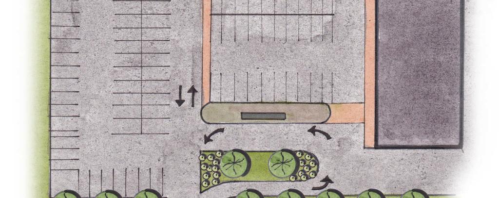
15 Page 14 The photo above shows the entrance to the 25th Street Shopping Center in Palmer Township. As can be seen in the photo, sidewalks on 25th Street do not continue into the shopping center and there is no pedestrian network internally throughout the development. The rendering below shows how the shopping center could allow for convenient pedestrian access into, out of, and throughout the shopping center.


16 Page 15 The photo above provides a ground level perspective of the 25th Street Shopping Center in Palmer Township. As noted, sidewalks do not continue into the shopping center and there are large expanses of parking that need to be crossed by a pedestrian to reach the retail stores. The rendering below shows how the extension of sidewalks and the incorporation of satellite buildings can significantly improve the pedestrian environment.


17 Why are these Site Planning Elements Important? Site plans that do not conform with the transit supportive attributes listed earlier can have a deleterious effect on the convenience, reliability and cost of local transit service. This is due to the amount of time that is required to leave the main thoroughfare and directly serve individual developments. The graphic below shows a simple bus route which does not deviate off of the main street it is serving. In the graphic, the red arrow shows service in one direction, for example westbound service, and the blue shows the same bus route operating in the opposite direction (in this example, eastbound service). In the graphic, the westbound trip takes 25 minutes and the eastbound trip takes 25 minutes for a total of 50 minutes for the cycle, or round trip. In transit schedules, time is built in at the end of round trips to allow for "recovery". That is, if the bus begins to run late on one trip, they can "recover" at the end of the trip and begin the next trip on time. This allows for greater on-time performance and reliability of the service. In addition, time at the end of the line also allows the driver a short break to use the restrooms, etc. Page 16 Example Transit Corridor
18 This schedule, as summarized below, is an ideal schedule in that it ensures reliability of service throughout the day by allowing for sufficient recovery time. With the added recovery time, the full scheduled cycle is 60 minutes. This would allow the transit provider to operate service along this corridor every 30 minutes using two buses. Measure Round Trip Running Time Recovery Time Total Cycle Time Frequency of Service Buses needed to maintain frequency Requirements 0:50 0:10 0:60 Every 30 mins 2 Page 17 However, as development occurs it can often change the nature of a corridor. In the graphic on the following page, a new commercial development has been built along the corridor shown above. In this example, there is no pedestrian network linking the development to the main thoroughfare and no safe and convenient way to cross the main thoroughfare. Therefore, to provide convenient service to this new development for transit riders, the bus route must now deviate off of the main road to serve the new development in both the eastbound and westbound directions (people need to get there and later make a return trip).


19 Page 18 Example Transit Corridor with New Commercial Development
20 Due to the multitude of factors that result in a very slow pace of traffic in commercial developments (e.g., double parked vehicles, delivery trucks, heavy pedestrian activity, etc), a bus would take a minimum of three minutes, on average, to traverse a commercial development and return to the main road. With the new routing shown in the graphic on the previous page, the westbound trip now takes 28 minutes and the eastbound trip takes 28 minutes. Applying this to the cycle time calculations renders the following results: Measure Round Trip Running Time Recovery Time Total Cycle Time Frequency of Service Buses needed to maintain frequency Requirements 0:56 0:04 0:60 Every 30 mins 2 The bus route can still be operated at a frequency of every 30 minutes, however, the amount of recovery time has now been reduced to 4 minutes. This provides less of a chance to recover if a trip is delayed for some reason. This limited amount of recovery time could affect the overall reliability of the service in that multiple trips could end up operating late if the bus falls behind schedule. Page 19 The scheduling of a bus route becomes more complicated as development continues along a corridor. In the graphic on the following page, a second large commercial development is built along the corridor. Like the previous commercial development, there is no pedestrian network linking the development to the main thoroughfare and no safe and convenient way to cross the main thoroughfare. In addition, the developments are not connected to one another. Therefore, to provide convenient bus service to this newer development for transit riders, the bus route must now deviate off of the main road to also serve the newer development in both the eastbound and westbound directions.


21 Page 20 Example Transit Corridor with Multiple New Commercial Developments
22 Again, given that each deviation will require at least three minutes to serve the development and return to the main road, another six minutes is now added to the round trip running time of the route. The table below shows the effect of this on the schedule for the bus route: Measure Round Trip Running Time Recovery Time Total Cycle Time Frequency of Service Buses needed to maintain frequency Requirements 0:62 0:00 0:62?? With these deviations, the total cycle time is now over 60 minutes requiring a decision about the bus route. One option is to reduce service from every 30 minutes to perhaps every 40 minutes which makes the service much less convenient. The second option would be to add a third bus to the cycle to maintain the 30 minute frequency, but using a third bus to cover the route will increase the cost significantly. What this example shows is that developments that are not in line with the transit supportive site planning criteria put forth in this report can have material effects on the quality and cost of local transit service. Making transit less convenient and more costly runs counter to the goal of promoting transit and other alternative forms of transportation in a community. When these conditions cannot be met... There may be conditions that require buildings to be set further back than 235' from the road and/or there is no possibility to allow for pedestrian access to the site. When this is the case, it is often necessary for transit buses to leave the main road and traverse a development to provide convenient transit access to the development. Under these conditions, there are certain design elements that can improve the efficiency and effectiveness of transit service to the site. These include: Minimize the need for internal circulation - If a bus route has to enter a development to provide service, the site plan should provide for a circulation pattern for buses that minimizes the amount of time the bus must spend within the development. This could be done by providing a transit stop at a location immediately within the development that allows transit riders direct access to a pedestrian network that connects to all areas of the development. The transit stop should also be situated in a way to allow buses to then quickly and feasibly exit from the development. Page 21 The graphic on the following page shows how a transit plaza could be incorporated into a site plan to provide a location immediately within a development that would act as the location of the transit stop for the development. Buses could serve the stop then return to the main road without the need to traverse the entire development.

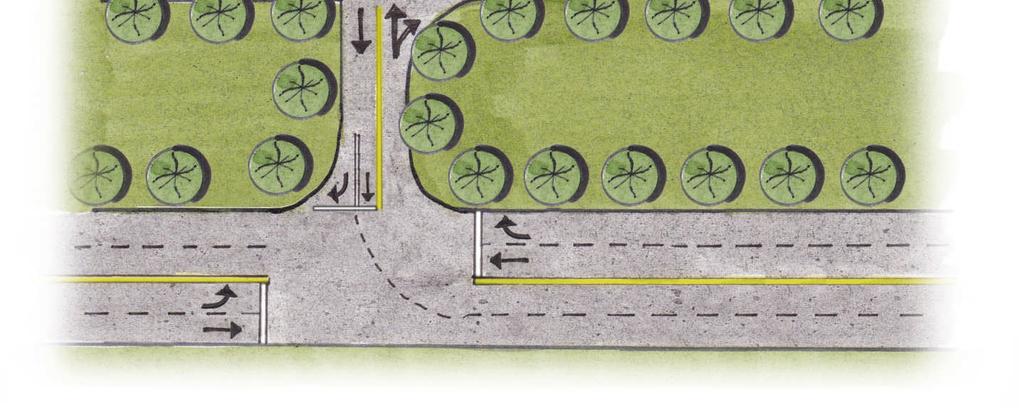
23 Page 22 Commercial Development with Transit Plaza


24 Provide for a circulation pattern that allows for continuous forward motion - Site plans should also provide for a circulation pattern that would allow buses to maintain continuous forward motion along a route rather than the need to "double back". The graphic below is a modification of the graphic on page 22. The site plan below incorporates a transit plaza with bus stops in both directions, which both connect to the pedestrian network. This layout allows buses to enter and exit the shopping center while maintaining forward motion in both directions of travel. In all instances, transit stops within developments must meet Americans with Disabilities Act (ADA) requirements. The length of the transit stop must have curbing and ADA accessible ramps connecting to the pedestrian circulation network. At the transit stop, there should be no vegetated strip between the sidewalk/passenger waiting area and the curb. Page 23 Commercial Development with Transit Plaza Accommodating Bi-Directional Movement
 at higher densities than the immediately surrounding areas.")

25 4. Centers Municipalities should encourage the development or redevelopment of village centers or mixed higher density nodes of development at various junctures along corridors. Ideally, these nodes should have a mix of uses (i.e., residential and commercial) at higher densities than the immediately surrounding areas. They should also include pedestrian infrastructure and site designs complying with the concepts outlined in the above sections. This is consistent with the goals of many community Comprehensive Plans which call for the redevelopment of traditional village centers, or the creation of activity centers through zoning that allows for mixed use development and higher densities. Page 24 This rendering shows how the intersection of Broadway and 39th Street in Cetronia, South Whitehall Township could incorporate slightly higher densities and mixed uses to create a node of activity along a current bus route.


26 The existence of higher density, mixed use nodes along a transit corridor can help to improve the productivity of transit service, that is, the number of people carried per trip. The nodes provide added destinations along a route and the mix of uses allows the route to serve different trip purposes. The graphics below show two hypothetical corridors. Corridor A shows a corridor running between a low density suburban residential and highway commercial area connecting to a central business district (CBD). Corridor B shows the same corridor with two higher density mixed use development nodes along the corridor. Corridor A Corridor B Page 25 Demand for transit service along Corridor A will follow a pattern of people boarding at various stops along the route in the morning peak and deboarding the bus in the CBD. Very few passengers will get off at stops along the corridor prior to the CBD. Also, trips emanating from the CBD in the morning and heading out to the end of the corridor will receive very limited demand since low density residential areas are not prime attractors of incoming trips during the morning peak.
27 During the afternoon along Corridor A, the opposite pattern will be observed with most riders boarding the bus in the CBD and deboarding at various stops along the route. Very few riders will board the bus outside of the CBD. Also, transit trips traveling from the end of the corridor into the CBD will receive very little demand. During the midday, the route will receive little demand in either direction because demand to and from a CBD is highly peaked in the traditional morning and afternoon peak commute times. The corridor has few other destinations to attract any other demand outside of those times. Given the nodes of mixed use, higher density development along Corridor B, demand for transit service along the corridor will now follow a different pattern. First, overall demand will increase due to the added density and transit supportive development. Also, during the morning peak, the primary trip pattern will still be from the residential areas to the CBD, however, more passengers will also be deboarding the bus in the nodes to access the new destinations. Also, transit trips in the opposite direction during the morning will attract more demand with riders boarding in the CBD and the inner parts of the corridor traveling out to destinations in the nodes. Similar diversification of demand will be observed during the afternoon peak. In addition, the mix of uses in the nodes will result in increased demand for midday service along the corridor with riders traveling from various origins to destinations within the nodes. Page 26 The most important benefit of the addition of these nodes is that demand for transit service along this corridor has been enhanced without the need for costly additions of new routes or the extension of an existing route.
28 Summary To assist municipalities in determining whether their community in general or specific development plans can be considered transit supportive, the table below provides a checklist of the points covered in this document. Community Wide Does the community have sufficient densities of employment and population along key thoroughfares to support desired transit levels in accordance with LANta's guidelines? Does the community have a comprehensive sidewalk network including: Sidewalks on both sides of all streets and throughout commercial developments; Marked crosswalks at intersections; Pedestrian islands for crossing wide streets; and Pedestrian only phases in traffic signals where pedestrian traffic is heavy? Does the community have mixed use nodes with enhanced densities and pedestrian infrastructure along major thoroughfares? Specific Development Plans Is the development located along a LANta route and does that route currently provide sufficient service to meet the nature of the demand anticipated? Can pedestrians use accessible sidewalks and marked crosswalks to walk into and out of this development from both sides of the street on which the development is located? Can pedestrians use accessible sidewalks and marked crosswalks to walk throughout the development? Are the primary buildings situated within a walk of 235 feet for developments of over 50,000 square feet and within a walk of 150 feet for developments under 50,000 square feet? In addition, many employers express interest in adopting transit supportive policies. Some simple steps employers can take to make their workplaces more transit supportive include: When choosing locations for your business, locate along a corridor which already receives the level of transit service you anticipate will be needed by your employees (e.g., if your business has night shift workers, make sure there is transit service in the evening hours when assessing locations); Choose to locate in buildings which meet the transit supportive development guidelines described in this document; and Provide financial incentives to your employees to use transit to commute to work (i.e., discounts on transit passes). Page 27 If the above conditions are not met, does the plan include a designated transit stop that: Allows for minimal circulation by LANta buses within the site; Allows LANta buses to maintain continuous forward motion; and Is connected to a comprehensive pedestrian network throughout the site?
29 Municipalities, developers and employers all share goals with LANta in promoting transit and transit use in the Lehigh Valley. Following the precepts outlined in this document is important in meeting that goal, but it should also be stressed that it is important to bring LANta into discussions regarding new developments or redevelopments early in any process so that LANta planners can make suggestions on how to best accommodate transit and transit riders on the site. Page 28 The work that provided the basis for this publication was supported by funding through Lehigh Valley Economic Development Corporation under an award with the U.S. Department of Housing and Urban Development. The substance and findings of the work are dedicated to the public. The author and publisher are solely responsible for the accuracy of the statements and interpretations contained in this publication. Such interpretations do not necessarily reflect the view of the U.S. Government.
Exhibit 1 PLANNING COMMISSION AGENDA ITEM
 Exhibit 1 PLANNING COMMISSION AGENDA ITEM Project Name: Grand Junction Circulation Plan Grand Junction Complete Streets Policy Applicant: City of Grand Junction Representative: David Thornton Address:
Executive Summary Route 30 Corridor Master Plan
 Route Corridor Master Plan Project Overview The Route Corridor Master Plan is a coordinated multimodal transportation and land use plan for the entire stretch of Route through East Whiteland Township,
Purpose and Need. Chapter Introduction. 2.2 Project Purpose and Need Project Purpose Project Need
 Chapter 2 Purpose and Need 2.1 Introduction The El Camino Real Bus Rapid Transit (BRT) Project (Project) would make transit and other transportation improvements along a 17.6-mile segment of the El Camino
Circulation in Elk Grove includes: Motor vehicles, including cars and trucks
 Circulation, as it is used in this General Plan, refers to the many ways people and goods move from place to place in Elk Grove and the region. Circulation in Elk Grove includes: Motor vehicles, including
Sixth Line Development - Transit Facilities Plan
 Memorandum Date: November 13, 2012 To: From: c.c. Subject: Rob Freeman (Freeman Planning) Kevin Phillips Sixth Line Development - Transit Facilities Plan 33016631 This memo was prepared to review the transit
Chapter 7. Transportation. Transportation Road Network Plan Transit Cyclists Pedestrians Multi-Use and Equestrian Trails
 Chapter 7 Transportation Transportation Road Network Plan Transit Cyclists Pedestrians Multi-Use and Equestrian Trails 7.1 TRANSPORTATION BACKGROUND The District of Maple Ridge faces a number of unique
ATTACHMENT 4 - TDM Checklist. TDM Checklist Overview
 ATTACHMENT 4 - TDM Checklist TDM Checklist Overview The proposed checklist rates developments on the degree to which they are TDM and transit supportive. Points are assigned based on the level of transit
City of Wayzata Comprehensive Plan 2030 Transportation Chapter: Appendix A
 A1. Functional Classification Table A-1 illustrates the Metropolitan Council s detailed criteria established for the functional classification of roadways within the Twin Cities Metropolitan Area. Table
Proposed. City of Grand Junction Complete Streets Policy. Exhibit 10
 Proposed City of Grand Junction Complete Streets Policy Exhibit 10 1 City of Grand Junction Complete Streets Policy Vision: The Complete Streets Vision is to develop a safe, efficient, and reliable travel
Contents. Champaign-Urbana Mass Transit District Stop Placement Guidelines
 Contents Champaign-Urbana Mass Transit District Introduction... 1 Stop Spacing... 2 Rural... 2 Low Density Suburban... 2 General Urban... 2 Urban Core... 2 Operational Safety... 3 Stop Placement... 4 Nearside
SECTION 1 - TRAFFIC PLANNING
 SECTION 1 - TRAFFIC PLANNING 1.1 TRAFFIC OPERATIONS 1.1.1 Roadway Functional Classification The Multnomah County Comprehensive Framework Plan s Policy 34: Trafficways and the Functional Classification
In station areas, new pedestrian links can increase network connectivity and provide direct access to stations.
 The Last Mile Planning for Pedestrians Planning around stations will put pedestrians first. Making walking to stations safe and easy is important; walking will be a part of every rapid transit Accessible
Chapter 2. Bellingham Bicycle Master Plan Chapter 2: Policies and Actions
 Chapter 2 Bellingham Bicycle Master Plan Chapter 2: Policies and Actions Chapter 2: Policies and Actions The Bicycle Master Plan provides a road map for making bicycling in Bellingham a viable transportation
Southwest Bus Rapid Transit (SW BRT) Functional Planning Study - Executive Summary January 19 LPT ATTACHMENT 2.
 Functional Planning Study - Executive Summary January 19 LPT ATTACHMENT 2.") Southwest Bus Rapid Transit (SW BRT) Functional Planning Study - Executive Summary 2011 January 19 1 of 19 Introduction This executive summary presents the results of the Southwest Bus Rapid Transit (SW
Southwest Bus Rapid Transit (SW BRT) Functional Planning Study - Executive Summary 2011 January 19 1 of 19 Introduction This executive summary presents the results of the Southwest Bus Rapid Transit (SW
Pocatello Regional Transit Master Transit Plan Draft Recommendations
 Pocatello Regional Transit Master Transit Plan Draft Recommendations Presentation Outline 1. 2. 3. 4. What is the Master Transit Plan? An overview of the study Where Are We Today? Key take-aways from existing
CITY OF COCOA BEACH 2025 COMPREHENSIVE PLAN. Section VIII Mobility Element Goals, Objectives, and Policies
 CITY OF COCOA BEACH 2025 COMPREHENSIVE PLAN Section VIII Mobility Element Goals, Objectives, and Policies Adopted August 6, 2015 by Ordinance No. 1591 VIII MOBILITY ELEMENT Table of Contents Page Number
Operational Comparison of Transit Signal Priority Strategies
 Operational Comparison of Transit Signal Priority Strategies Revision Submitted on: November, 0 Author: Adriana Rodriguez, E.I Assistant Engineer Parsons Brinckerhoff 0 South Orange Avenue, Suite 00 Orlando,
ADOT Statewide Bicycle and Pedestrian Program Summary of Phase IV Activities APPENDIX B PEDESTRIAN DEMAND INDEX
 ADOT Statewide Bicycle and Pedestrian Program Summary of Activities APPENDIX B PEDESTRIAN DEMAND INDEX May 24, 2009 Pedestrian Demand Index for State Highway Facilities Revised: May 29, 2007 Introduction
CONNECTING PEOPLE TO PLACES
 CONNECTING PEOPLE TO PLACES 82 EAST BENCH MASTER PLAN 07 Introduction The East Bench transportation system is a collection of slow moving, treelined residential streets and major arteries that are the
COWETA HIGH SCHOOL AND EAST HIGHWAY 51
 COWETA HIGH SCHOOL AND EAST HIGHWAY 51 Lack of sidewalks along Ben Lumpkin Rd. Lack of crosswalks and ramps at intersection. Hwy 51 is wide to cross as a pedestrian. No ADA compliance or connection to
Chapter 2: Standards for Access, Non-Motorized, and Transit
 Standards for Access, Non-Motorized, and Transit Chapter 2: Standards for Access, Non-Motorized, and Transit The Washtenaw County Access Management Plan was developed based on the analysis of existing
4 Ridership Growth Study
 Clause 4 in Report No. 15 of Committee of the Whole was adopted, without amendment, by the Council of The Regional Municipality of York at its meeting held on November 16, 2017. 4 Ridership Growth Study
ADA Transition Plan. City of Gainesville FY19-FY28. Date: November 5, Prepared by: City Of Gainesville Department of Mobility
 ADA Transition Plan FY19-FY28 Date: November 5, 2018 Prepared by: City Of Gainesville Department of Mobility 1.0 INTRODUCTION 1.1 BACKGROUND The federal statute known as the Americans with Disabilities
S T A T I O N A R E A P L A N
 The Circulation and Access Plan describes vehicle, pedestrian, and transit improvements recommended within the Concept Plan. In order to create and sustain a vibrant business district that provides pedestrian-friendly
Downtown BRT Corridor Alternatives Review: 1 st, 2 nd, 3 rd and 4 th Avenue. Bus Rapid and Conventional Transit Planning and Design Services
 Downtown BRT Corridor Alternatives Review: 1 st, 2 nd, 3 rd and 4 th Avenue Bus Rapid and Conventional Transit Planning and Design Services City of Saskatoon February 2018 Project Team HDR Corporation
Welcome. If you have any questions or comments on the project, please contact:
 Welcome This drop-in public open house is intended to provide information about the Bay Street bike lanes project. This project proposes a dedicated cycling facility along Bay Street between Aberdeen Avenue
Classification Criteria
 SCHEDULE D TO RECOMMENDED OFFICIAL PLAN AMENDMENT NO. 40 SCHEDULE C-4 Road Criteria Criteria Traffic Service Objective Land Service/Access Typical Daily Traffic Volume Flow characteristics Travel Speed
AMATS Complete Streets Policy
 AMATS Complete Streets Policy Table of Contents: Section 1. Definition of Complete Streets Section 2. Principles of Complete Streets Section 3. Complete Streets Policy Section 4. Consistency Section 5.
Planning Regionally With Transit
 Planning Regionally With Transit Nathan Coats Director of Operations CTAA Expo 2015 Tampa Began 1992. Serves eastern Cache County to Preston, ID. Population- 115,000 34 bus fleet, 26 fixed route buses;
Rochester Area Bike Sharing Program Study
 roc bike share Rochester Area Bike Sharing Program Study Executive Summary ~ January 2015 JANUARY 2015 8484 Georgia Avenue, Suite 800 Silver Spring, MD 20910 3495 Winton Pl., Bldg E, Suite 110 Rochester,
APPENDIX A: Complete Streets Checklist DRAFT NOVEMBER 2016
 APPENDIX A: Complete Streets Checklist DRAFT NOVEMBER 2016 Complete Streets Checklist MetroPlan Orlando s Complete Streets Checklist is an internal planning tool for staff to further implementation of
Multimodal Through Corridors and Placemaking Corridors
 68 Multimodal Through Corridors and Placemaking Corridors Corridors have different functions in a region. Some corridors are used to get smoothly and rapidly through a region or to get quickly to major
APPENDIX B. TDM Existing Conditions
 APPENDIX B TDM Existing Conditions SCARBOROUGH CENTRE TMP TRANSPORTATION DEMAND MANAGEMENT INTRODUCTION Scarborough Centre has grown into a mixed-use hub for population, transportation, and employment
PEDESTRIAN ACTION PLAN
 ATTACHMENT 2 CITY OF SANTA MONICA PEDESTRIAN ACTION PLAN CITY OF SANTA MONICA PEDESTRIAN ACTION PLAN This page intentionally left blank EXECUTIVE SUMMARY CHAPTER 1 EXECUTIVE SUMMARY Setting the Stage
Clackamas County Comprehensive Plan
 ROADWAYS The County s road system permits the movement of goods and people between communities and regions, using any of a variety of modes of travel. Roads provide access to virtually all property. They
South King County High-Capacity Transit Corridor Study
 HIGH-CAPACITY TRANSIT CORRIDOR STUDY South King County Corridor South King County High-Capacity Transit Corridor Study Corridor Report August 2014 South King County High Capacity Transit Corridor Report
o n - m o t o r i z e d transportation is an overlooked element that can greatly enhance the overall quality of life for the community s residents.
 N o n - m o t o r i z e d transportation is an overlooked element that can greatly enhance the overall quality of life for the community s residents. 84 Transportation CHAPTER 11 INTRODUCTION Transportation
Omaha s Complete Streets Policy
 Omaha s Complete Streets Policy (Adopted August 2015) VISION To create great places and enhance our quality of life, the City of Omaha will provide safe, accessible streets for all users. Complete Streets
City of Gainesville Transportation/Roadway Needs PROJECT SUMMARY
 A1 Roadway Resurfacing $23,846,000 TYPE: Preservation of existing system Roadway resurfacing A2 Signal Replacement $6,000,000 TYPE: Preservation of existing system Replace traffic signals. B1 W 6th St
Standing Committee on Policy and Strategic Priorities. Mount Pleasant Industrial Area Parking Strategy and Access Improvements
 POLICY REPORT Report Date: April 23, 2018 Contact: Lon LaClaire Contact No.: 604.873.7722 RTS No.: 9944 VanRIMS No.: 08-2000-20 Meeting Date: May 16, 2018 TO: FROM: SUBJECT: Standing Committee on Policy
Capital and Strategic Planning Committee. Item III - B. April 12, WMATA s Transit-Oriented Development Objectives
 Capital and Strategic Planning Committee Item III - B April 12, 2018 WMATA s Transit-Oriented Development Objectives Page 24 of 76 Washington Metropolitan Area Transit Authority Board Action/Information
Solana Beach Comprehensive Active Transportation Strategy (CATS)
") Solana Beach Comprehensive Active Transportation Strategy (CATS) 3.0 Goals & Policies The Solana Beach CATS goals and objectives outlined below were largely drawn from the Solana Beach Circulation Element
Solana Beach Comprehensive Active Transportation Strategy (CATS) 3.0 Goals & Policies The Solana Beach CATS goals and objectives outlined below were largely drawn from the Solana Beach Circulation Element
CONNECTIVITY PLAN. Adopted December 5, 2017 City of Virginia Beach
 CONNECTIVITY PLAN Adopted December 5, 2017 City of Virginia Beach CONTENTS 1.0 Background & Purpose... 2 2.0 Existing Inventory & Analysis... 3 ViBe District Existing Walking Conditions... 4 3.0 ViBe District
INTRODUCTION THOROUGHFARE SYSTEM CLASSIFICATIONS
 INTRODUCTION The thoroughfare plan will assist public officials in the development of a specialized system for efficient and safe movement of vehicular traffic while minimizing potential conflicts with
CITY OF VAUGHAN EXTRACT FROM COUNCIL MEETING MINUTES OF OCTOBER 30, 2012
 CITY OF VAUGHAN EXTRACT FROM COUNCIL MEETING MINUTES OF OCTOBER 30, 2012 Item 31, Report No. 39, of the Committee of the Whole, which was adopted without amendment by the Council of the City of Vaughan
Hennepin County Pedestrian Plan Public Comment Report
 Hennepin County Pedestrian Plan Public Comment Report On May 31, 2013, the draft Hennepin County Pedestrian Plan was released for a 45-day public comment period ending July 15, 2013. The county received
Route 7 Corridor Study
 Route 7 Corridor Study Executive Summary Study Area The following report analyzes a segment of the Virginia State Route 7 corridor. The corridor study area, spanning over 5 miles in length, is a multi
Transportation, Parking & Roads
 Transportation, Parking & Roads Design Carolina North as a walkable community Design the transportation system and development patterns (i.e., urban design elements such as density, building design, mix
NJDOT Complete Streets Checklist
 Background The New Jersey Department of Transportation s Complete Streets Policy promotes a comprehensive, integrated, connected multi-modal network by providing connections to bicycling and walking trip
2014/2015 BIKE ROUTE PLAN 83 AVENUE PROTECTED BIKE LANE
 About the Project 2014/2015 BIKE ROUTE PLAN The City of Edmonton is planning a major bike route on the south side of Edmonton. This bike route is one part of a plan to provide citizens with transportation
4 DISRUPTION MANAGEMENT PLAN HIGHWAY 7 RAPIDWAY CONSTRUCTION BETWEEN BAYVIEW AVENUE AND WARDEN AVENUE TOWNS OF MARKHAM AND RICHMOND HILL
 4 DISRUPTION MANAGEMENT PLAN HIGHWAY 7 RAPIDWAY CONSTRUCTION BETWEEN BAYVIEW AVENUE AND WARDEN AVENUE TOWNS OF MARKHAM AND RICHMOND HILL The Transportation Services Committee recommends the adoption of
North Coast Corridor:
 North Coast Corridor: Connecting People, Transportation & Environment Legislative Hearing: 11.8.10 1 North Coast Corridor Region s Lifeline A Regional Strategy Mobility, Economy & Environment North Coast
How To Encourage More Efficient Transportation in Brazilian Cities
 How To Encourage More Efficient Transportation in Brazilian Cities Todd Litman Victoria Transport Policy Institute Presented Seminar on Discouraging The Use Of Cars São Paulo, Brazil 3 September 2013 Creating
CITY OF ALPHARETTA DOWNTOWN MASTER PLAN TRAFFIC EVALUATION
 CITY OF ALPHARETTA DOWNTOWN MASTER PLAN TRAFFIC EVALUATION June 2015 CITY OF ALPHARETTA DOWNTOWN MASTER PLAN TRAFFIC EVALUATION Introduction The Alpharetta Downtown Master Plan was developed in the fall
Report. Typical Sections. City of Middleton, WI
 Report Typical Sections City of Middleton, WI December 2006 Report for City of Middleton, Wisconsin Typical Sections repared by: Traffic Associates LLC and STRAND ASSOCIATES, INC. 910 West Wingra Drive
City of Elizabeth City Neighborhood Traffic Calming Policy and Guidelines
 City of Elizabeth City Neighborhood Traffic Calming Policy and Guidelines I. Purpose: The City of Elizabeth City is committed to ensure the overall safety and livability of residential neighborhoods. One
Chapter 5 Future Transportation
 Chapter 5 Future Transportation The Future Land Use Plan identifies the desired land use designations. The land uses desired for Crozet depend, in large part, on the success of the transportation system,
Roadway Classification Design Standards and Policies. Pueblo, Colorado November, 2004
 Roadway Classification Design Standards and Policies Pueblo, Colorado November, 2004 Table of Contents Page Chapter 1. General Provisions 1.1 Jurisdiction 3 1.2 Purpose and Intent 3 1.3 Modification 3
4. ENVIRONMENTAL IMPACT ANALYSIS 9. TRANSPORTATION AND TRAFFIC
 4. ENVIRONMENTAL IMPACT ANALYSIS 9. TRANSPORTATION AND TRAFFIC 4.9.1 INTRODUCTION The following section addresses the Proposed Project s impact on transportation and traffic based on the Traffic Study
Chapter 6 Transportation Plan
 Chapter 6 Transportation Plan Transportation Plan Introduction Chapter 6 Transportation Plan Transportation Plan Introduction This chapter describes the components of Arvada s transportation system, comprised
CPC Parking Lot Riverside Drive. Transportation Rationale
 CPC Parking Lot Transportation Rationale Prepared By: NOVATECH Suite 200, 240 Michael Cowpland Drive Ottawa, Ontario K2M 1P6 September 2015 Novatech File: 114093 Ref: R-2015-153 Table of Contents 1.0 INTRODUCTION...
Moving Cambridge. City of Cambridge Transportation Master Plan Public Consultation Centre. March 7, :00 8:00 PM.
 City of Cambridge Transportation Master Plan Public Consultation Centre March 7, 2018 5:00 8:00 PM Region of Waterloo City of Cambridge Transportation Master Plan Public Consultation Centre March 7, 2018
MEETING Agenda. Introductions. Project Overview. Key Study Components. Alternative Station Concepts. Preferred Station Concept. Next Steps.
 City GARLAND Council ROADVISION Briefing STUDY VISION STUDY Dallas, TX April 8, 2010 1 1 MEETING Agenda Introductions Project Overview Key Study Components Alternative Station Concepts Preferred Station
Highway 49, Highway 351 and Highway 91 Improvements Feasibility Study Craighead County
 Highway 49, Highway 351 and Highway 91 Improvements Feasibility Study Craighead County Executive Summary March 2015 Highway 49, Highway 351 and Highway 91 Improvements Feasibility Study Craighead County
2025 Comprehensive Plan for the City of Temple Terrace Florida. Mobility Element. Adopted by City Council June 30, 2009
 2025 Comprehensive Plan for the City of Temple Terrace Florida Mobility Element Adopted by City Council June 30, 2009 Effective Date September 22, 2009 GOAL 2: To protect and promote the quality of life
Having held a public hearing, that Council approve:
 3. MODIFICATIONS TO MERIVALE ROAD FROM FALLOWFIELD ROAD TO OLD HIGHWAY 16 TO ACCOMMODATE THE GROWTH WITHIN THE SOUTH MERIVALE BUSINESS PARK - PUBLIC HEARING COMMITTEE RECOMMENDATIONS Having held a public
EXECUTIVE SUMMARY: TRANSIT-ORIENTED DEVELOPMENT IN SMITHS FALLS, ONTARIO; A COMPARISON BETWEEN TWO SITES
 EECUTIVE SUMMARY: TRANSIT-ORIENTED DEVELOPMENT IN SMITHS FALLS, ONTARIO; A COMPARISON BETWEEN TWO SITES Topic and Purpose In 2007, the Mayor of Ottawa s Task Force on Transportation suggested adding a
Prepared For: Shieldbay Developments Inc. c/o Matson, McConnell Ltd. 2430A Bloor Street West Toronto, Ontario M6S 1P9.
 Prepared For: Shieldbay Developments Inc. c/o Matson, McConnell Ltd. 2430A Bloor Street West Toronto, Ontario M6S 1P9 Prepared By: URS Canada Inc. 4 th Floor, 30 Leek Crescent Richmond Hill, Ontario L4B
ROUTES 55 / 42 / 676 BUS RAPID TRANSIT LOCALLY PREFERRED ALTERNATIVE
 ROUTES 55 / 42 / 676 BUS RAPID TRANSIT LOCALLY PREFERRED ALTERNATIVE April, 2012 1 INTRODUCTION The need for transit service improvements in the Routes 42/55/676 corridor was identified during the Southern
Bellevue Transportation: Challenges, Opportunities and Priorities Bellevue Downtown Association September 20, 2018
 Bellevue Transportation: Challenges, Opportunities and Priorities Bellevue Downtown Association September 20, 2018 Dave Berg Transportation Director City of Bellevue Traffic, traffic and more traffic!
MOUNTAIN HOUSE SPECIFIC PLAN I 9.1 INTRODUCTION ASSUMPTIONS TRANSPORTATION FACILITIES TRANSPORTATION IMPROVEMENTS PHASING 9.
 CHAPTER NINE: TRANSPORTATION AND CIRCULATION 9.1 INTRODUCTION 9.1 9.2 ASSUMPTIONS 9.1 9.3 TRANSPORTATION FACILITIES 9.1 9.4 TRANSPORTATION IMPROVEMENTS PHASING 9.3 LIST OF FIGURES LIST OF TABLES Figure
6.0 PEDESTRIAN AND BICYCLE FACILITIES 6.1 INTRODUCTION 6.2 BICYCLE DEMAND AND SUITABILITY Bicycle Demand
 6.0 PEDESTRIAN AND BICYCLE FACILITIES 6.1 INTRODUCTION Bicycle and pedestrian travel along and in the vicinity of the corridor is part of the vision of Somerset and Hunterdon counties and the integrated
WELCOME. City of Greater Sudbury. Transportation Demand Management Plan
 WELCOME City of Greater Sudbury Transportation Demand Management Plan Public Consultation Session St. Andrew s Place, Activity Hall 111 Larch Street Wednesday September 13, 2017 6:00 to 8:00 pm Welcome
City of Davenport CitiBus Public Transportation Study. April 2015
 City of Davenport CitiBus Public Transportation Study April 2015 Overview Project Background Key Findings CitiBus Service Allocation Policy Discussion 2 Project Background 3 About CitiBus Operates 17 routes
Bicycle and Pedestrian Advisory Committee (BPAC) November 21, 2013
 November 21, 2013") Bicycle and Pedestrian Advisory Committee (BPAC) November 21, 2013 OVERALL LAND USE CONCEPT Overall Broadway Valdez District: 95.5 acres (35.1 acres right-of ways + 60.4 acres developable land) Plan Subareas:
Bicycle and Pedestrian Advisory Committee (BPAC) November 21, 2013 OVERALL LAND USE CONCEPT Overall Broadway Valdez District: 95.5 acres (35.1 acres right-of ways + 60.4 acres developable land) Plan Subareas:
San Jose Transportation Policy
 San Jose Transportation Policy Protected Intersections in LOS Policies to Support Smart Growth Presented by: Manuel Pineda City of San Jose Department of Transportation Bay Area Map San Francisco Oakland
Coquitlam Cross-town Bike Route Improving Bicycle Facilities in a Mature Suburban Environment
 Coquitlam Cross-town Bike Route Improving Bicycle Facilities in a Mature Suburban Environment Sarah Rocchi, Vice-President, Projects, Opus International Consultants (Main Presenter) Catherine Mohoruk,
Recommended Roadway Plan Section 2 - Land Development and Roadway Access
 Recommended Roadway Plan Section 2 - Land Development and Roadway Access SECTION 2 Land Development and Roadway Access 2.1 Land Use and Access Management The Federal Highway Administration (FHWA) defines
to the Public Information Centre for the Downtown Traffic Study
 to the Public Information Centre for the Downtown Traffic Study City of Sault Ste. Marie July 25, 2018 Purpose of Study Determine if changes to one-way corridors can enhance downtown s character and spaces
TRANSIT & NON-MOTORIZED PLAN DRAFT FINAL REPORT Butte County Association of Governments
 1 INTRODUCTION Maintaining a high quality of life is the essence of this plan for transit and non-motorized transportation in Butte County. Curbing greenhouse gas emissions (GHG) by reducing congestion,
Vision: Traditional hamlet with an attractive business/pedestrian friendly main street connected to adjacent walkable neighborhoods
 N D. Focus Area II Vision: Traditional hamlet with an attractive business/pedestrian friendly main street connected to adjacent walkable neighborhoods Transit Road Focus Area II is located in the Hamlet
West Dimond Blvd Upgrade Jodhpur Street to Sand Lake Road
 West Dimond Blvd Jodhpur St to Sand Lake CSS Transportation Project Summary Municipality of Anchorage Project # 05 005 Project Manager: John Smith, P.E. (MOA PM&E) Project Administrator: Julie Makela,
Memorandum. Fund Allocation Fund Programming Policy/Legislation Plan/Study Capital Project Oversight/Delivery Budget/Finance Contract/Agreement Other:
 Memorandum Date: November 20, 2017 To: Transportation Authority Board From: Eric Cordoba Deputy Director Capital Projects Subject: 12/5/17 Board Meeting: San Francisco Freeway Corridor Management Study
WHITE PAPER: TRANSIT SERVICE FOR SOUTH SHAGANAPPI
 9/27/2012 TRANSIT PLANNING WHITE PAPER: TRANSIT SERVICE FOR SOUTH SHAGANAPPI 2012 Calgary Transit 1 Table of Contents Purpose... 3 Area of Change... 3 Background... 3 Access to destinations... 5 Connecting
D.13 Transportation and Traffic
 This section addresses transportation and traffic issues and impacts related to the Proposed Project. Section D.13.1 provides a description of the affected environment for the Proposed Project. Applicable
BELFAST RAPID TRANSIT. Ciarán de Búrca Director, Transport Projects Division Department for Regional Development
 BELFAST RAPID TRANSIT Ciarán de Búrca Director, Transport Projects Division Department for Regional Development Objectives of Belfast Rapid Transit To provide a modern, safe, efficient and high quality
SETTINGS AND OPPORTUNITIES MOBILITY & ACCESS
 7 mobility & access how do people use el camino what is it like to drive on el camino/to park along el camino what is the pedestrian experience like what is the role of transit along the corridor what
Town of Babylon Sustainable Complete Streets Policy
 Town of Babylon Sustainable Complete Streets Policy Steve Bellone, Supervisor Adopted July 14, 2010 1 Table of Contents Vision... 3 Policy Statement... 3 Definition... 3 Road Users... 4 Network... 4 Roads...
Corpus Christi Metropolitan Transportation Plan Fiscal Year Introduction:
 Introduction: The Safe, Accountable, Flexible, Efficient Transportation Equity Act: A Legacy for Users (SAFETEA-LU) has continued the efforts started through the Intermodal Surface Transportation Efficiency
City of Homewood Transportation Plan
 City of Homewood Transportation Plan Prepared for: City of Homewood, Alabama Prepared by: Skipper Consulting, Inc. May 2007 TABLE OF CONTENTS INTRODUCTION... 1 BACKGROUND INFORMATION... 1 EXISTING TRANSPORTATION
TRAVEL PLAN: CENTRAL EUROPEAN UNIVERSITY CAMPUS REDEVELOPMENT PROJECT TRAVEL PLAN. Central European University Campus Redevelopment Project.
 TRAVEL PLAN Central European University Campus Redevelopment Project Page 1 Table of Contents Introduction... 3 Background... 7 Building Users... 7 Transportation in Community Consultation... 7 Summary
CHAPTER 7.0 IMPLEMENTATION
 CHAPTER 7.0 IMPLEMENTATION Achieving the vision of the Better Streets Plan will rely on the ability to effectively fund, build and maintain improvements, and to sustain improvements over time. CHAPTER
102 Avenue Corridor Review
 February 26, 2015 102 Avenue Corridor Review Transportation Association of Canada Road Safety Engineering Award Submission for the City of Edmonton Introduction Transportation Association of Canada Road
This page intentionally left blank.
 This page intentionally left blank. COMMUNITY Coweta Community Overview Coweta Coweta, a residential community located in Wagoner County, is a suburb of Tulsa situated southeast of the metropolitan area
NEWMARKET UPHAM S CORNER
 SOUTH STATION Planning Initiative NEWMARKET UPHAM S CORNER COLUMBIA ROAD (P) FOUR CORNERS/GENEVA Working Advisory Group (WAG) Meeting #5 TALBOT AVENUE MORTON STREET BLUE HILL AVE/CUMMINS HWY (P) RIVER
ACTIVE TRANSPORTATION
 ACTIVE TRANSPORTATION Mobility 2040 Supported Goals Improve the availability of transportation options for people and goods. Support travel efficiency measures and system enhancements targeted at congestion
Summary: Mercer County Princeton Avenue & Spruce Street Study January 2009
 Summary: Several recent studies have assessed potential development and redevelopment opportunities in the Mercer Crossing area of Trenton, Ewing, and Lawrence. This Princeton Avenue and Spruce Street
5/7/2013 VIA . RE: University Village Safeway Expansion (P13-019)
") 5/7/2013 VIA EMAIL David Hung, Associate Planner Community Development Department, Current Planning Division City of Sacramento 300 Richards Boulevard, 3 rd Floor Sacramento, CA 95811 RE: University Village
5/7/2013 VIA EMAIL David Hung, Associate Planner Community Development Department, Current Planning Division City of Sacramento 300 Richards Boulevard, 3 rd Floor Sacramento, CA 95811 RE: University Village
Chapter 3 BUS IMPROVEMENT CONCEPTS
 Chapter 3 BUS IMPROVEMENT CONCEPTS The purpose of this chapter is to describe potential bus improvement strategies and potential impacts or implications associated with BRT implementation within the existing
Eastern PA Trail Summit October 1, 2018
 Eastern PA Trail Summit October 1, 2018 WHO WE ARE + WHY + WE RE * HERE * * * * * * Session Goals: Discuss how to coordinate planning and design in small, urbanized towns Consider how to develop alternative