The Rower Traffic Management Scheme
|
|
|
- Geoffrey Lindsey
- 5 years ago
- Views:
Transcription


1 KILKENNY COUNTY COUNCIL Comhairle Chontae Chill Chainnigh Section 38 of the Road Traffic Act, 1994 as amended by the Public Transport Regulation Act, 2009 (Section 46) The Rower Traffic Management Scheme EXPLANATORY BOOKLET March 2018
2 PROJECT DESCRIPTION AND PRINCIPLE FEATURES 1.0 Introduction This document has been prepared in accordance with Section 38 of the Road Traffic Act, 1994 as amended by the Public Transport Regulation Act, 2009 (Section 46), refer to Appendix 1 of this document for copy of Public Notice. Kilkenny County Council, as the Project Promoter, proposes to introduce a traffic management scheme along the R705 Regional Road on the southern side of The Rower village in the vicinity of Ard Mhuire National School and the Church of the Assumption. At present the existing parking arrangement in the vicinity of the school and church is haphazard and disorganised, particularly at school drop-off / collection and mass times. There are no footways on the eastern side of the carriageway and no designated facility for pedestrians or vulnerable road users to cross the road. The existing carriageway cross-section is very wide along the southern approach to the village at in excess of 12m. The carriageway alignment, the wide cross-section and set-back low building lines, fail to adequately alert drivers that they have entered into an urban / semi-urban space. This is particularly an issue at the school and church that adjoin the Regional Road. Recent speed surveys indicate that the 85th percentile speed is 73kph within the 30kph and 50kph speed limit zone illustrating a significant non compliance with the posted speed limits. The average annual daily traffic travelling along this section of road is in the order of 2,400 vehicles with 7% heavy goods vehicles. The road provides an important strategic route linking the south-eastern part of the county with the connecting Regional and National Road network and the larger urban areas in adjoining counties. The proposal put forward contains measures to address the above issues and offers substantial benefits to the local community.
3 2.0 Brief description of the proposed works The Scheme for consultation is to be funded by the Department of Transport, Tourism and Sport (DTTaS), under the Low Cost Safety Improvement Programme. The works proposed were designed to address the safety issues that exist at present and include the following: Standardisation of R705 Regional Road carriageway width to 6.0m through southern section of village; Provision of designated car and bus parking facilities in the vicinity of Ard Mhuire National School and the Church of the Assumption; Introduction of a one-way traffic management regime at the school and church Provision of new footpaths; Provision of new controlled and uncontrolled pedestrian crossing facilities; Provision of driver feedback signage to alert roadusers of actual speeds; Installation of signing and lining; Landscaping. Refer to Appendix 2 of this document to see preliminary plan layout drawing. 3.0 Scheme Benefits The proposed works will offer substantial benefits to the local community, namely:- Standardising the R705 carriageway width to 6.0m, through the southern section of the village, will greatly enhance driver awareness of the urban semi-urban area which in turn will alter driving behaviour, reduce traffic speeds and provide for the accommodation and comfort of pedestrians. The introduction of Speed Detection driver feedback signs will compliment the existing traffic calming signage, increase driver awareness of the urban realm and reduce the 85 th percentile traffic speed through the village.
4 Where the cross-section permits footpaths will be widened or constructed to a minimum width of 1.8m.. This new and safer pedestrian orientated streetscape with enhanced connectivity will provide safe access for users of all ages and degrees of personal mobility. The provision of regularised parking and set-down areas at Ard Mhuire National School and the Church of the Assumption will greatly improve safety for all road users, but in particular school children and other venerable road users. (Kilkenny County Council acknowledges the co-operation of the school and church in facilitating and supporting the proposed measures to be introduced). The proposed improvements will promote a sense of place, pride in the local rural community. The provision of additional landscaping & planting will improve the visual appearance of the area and enhance the urban realm. 4.0 Design Criteria The scheme shall be designed in accordance with the NRA Design Manual for Roads and Bridges and the DTTaS Design Manual for Urban Roads and Streets. 5.0 Funding Kilkenny County has secured funding of 60,000 from the Department of Transport, Tourism and Sport under the 2018 Non-national Road Low Cost Safety Improvement Programme. The funding secured will allow for Phase One of the works to be undertaken in the summer of Completion of Phase Two works will be dependent on future funding.
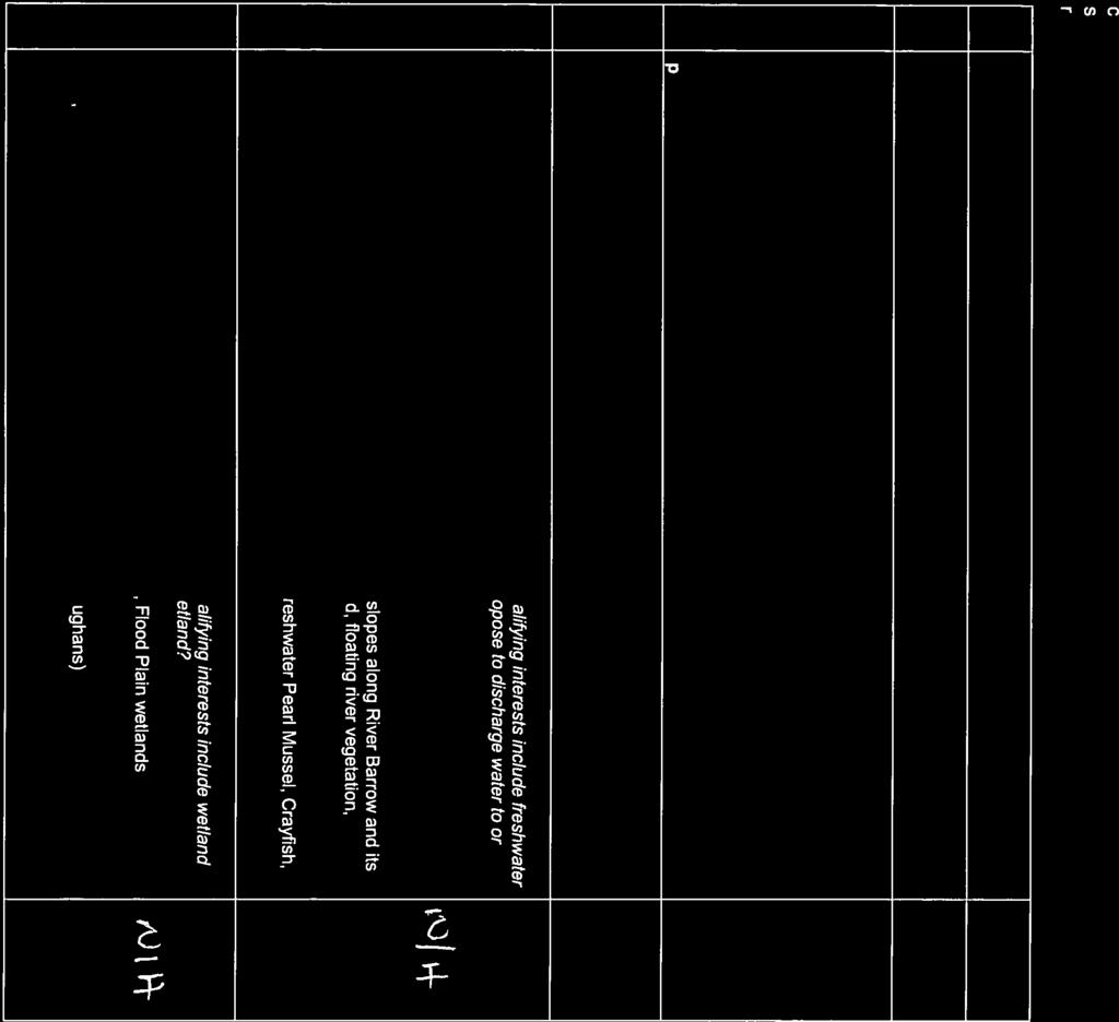
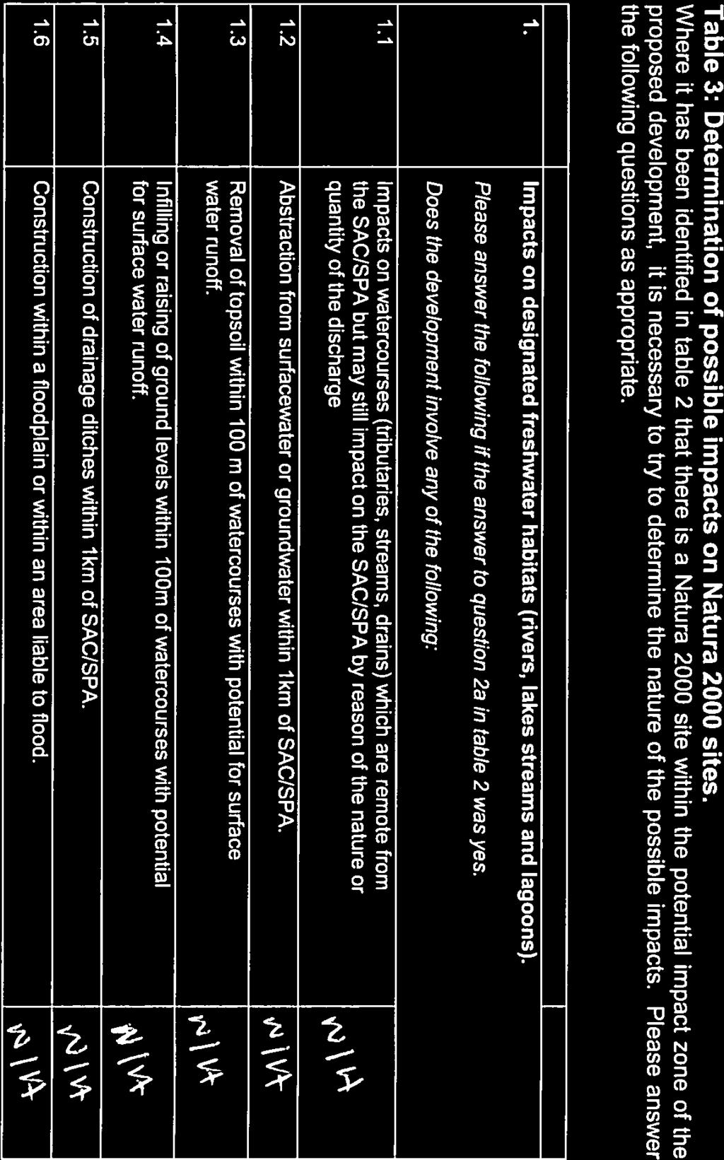
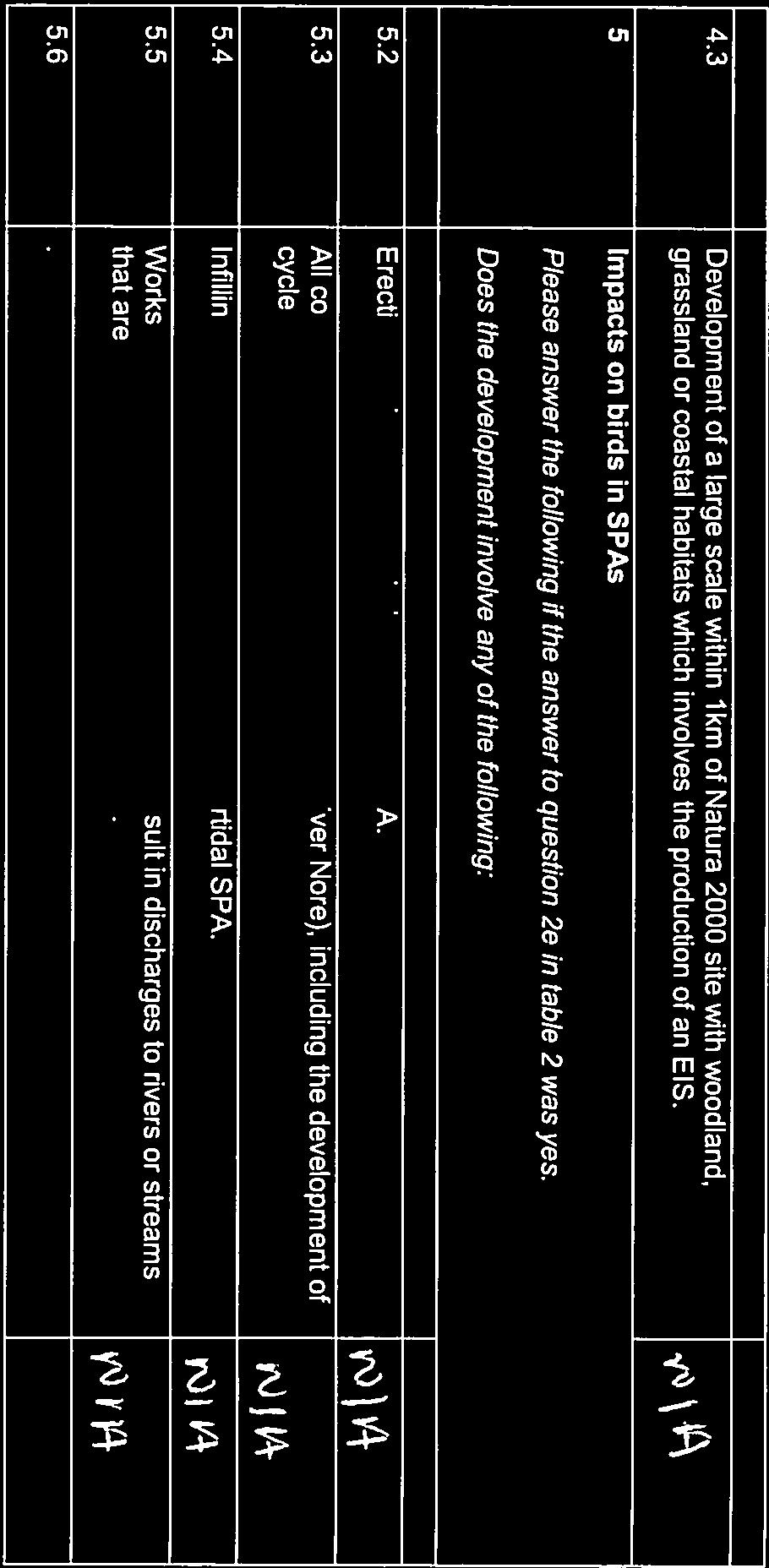
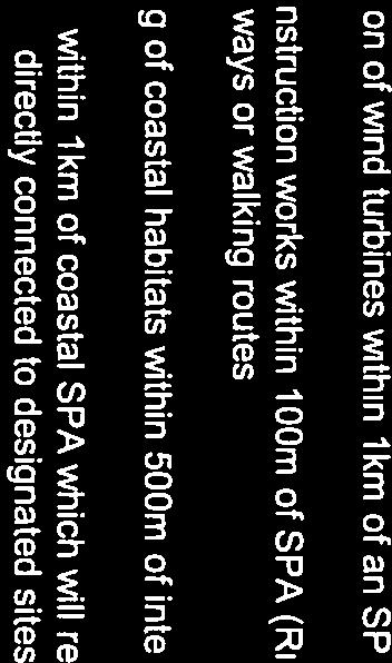
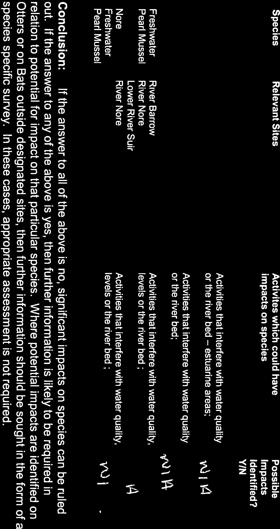
5 6.0 Habitats Directive Project Screening Assessment The Screening for Appropriate Assessment was undertaken by the Local Authority and a copy of this report is available in Appendix 3 of this booklet. 7.0 Submissions Representations and observations with respect to the proposed development may be made in writing to: Tim Butler Director of Services Kilkenny County Council County Buildings John Street Kilkenny Submissions should be clearly marked The Rower Traffic Management Scheme and the latest date for receipt of submissions is 4pm Friday 20 th April 2018.
6 Appendix 1 Copy of Public Notice

7 Public Notice in Compliance with the Road Traffic Act, 1994 (Section 38) as amended by the Public Transportation Regulation Act, 2009 (Section 46). The Rower Traffic Management Scheme Kilkenny County Council, in exercise of the powers conferred on it under Section 38 of the Road Traffic Act, 1994 as amended by the Public Transport Regulation Act, 2009 (Section 46), hereby gives notice of proposals pertaining to the following development: The provision of enhancements to the urban realm in The Rower, Co. Kilkenny, these works shall include the following: Standardisation of R705 Regional Road carriageway width to 6.0m through southern section of village; Provision of designated car and bus parking facilities in the vicinity of Ard Mhuire National School and the Church of the Assumption; Introduction of a one-way traffic management regime at the school and church Provision of new footpaths; Provision of new controlled and uncontrolled pedestrian crossing facilities; Provision of driver feedback signage to alert roadusers of actual speeds; Installation of signing and lining; Landscaping. Plans and particulars of the proposed development will be available for inspection from Friday 9th March 2018 to Friday 6th April 2018 inclusive, at the following Kilkenny County Council offices: Kilkenny County Council, County Buildings, John Street, Kilkenny City. Kilkenny County Council, Thomastown Area Office, Kilkenny Road, Thomastown. Post Office The Rower Co. Kilkenny From 9am to 1pm & 2pm to 5pm Monday to Friday (Except Public Holidays) From 9am to 1pm & 2pm to 5pm Monday to Friday (Except Public Holidays) From 9am to 1pm & 2pm to 5.30pm Monday to Friday (Except Public Holiday) Saturdays 9am to 1pm (Except Public Holidays) Submissions or observations with respect to the proposed development dealing with the proper planning and development of the area in which the development will be carried out may be made in writing to the undersigned. The latest date for receipt of comments on the above scheme is 4pm Friday 20th April Submissions should be clearly marked The Rower Traffic Management Scheme. T. Butler Director of Services Kilkenny County Council County Buildings, John Street, Kilkenny.
8 Appendix 2 Preliminary Plan Layout Drawing
9
10 Appendix 3 Habitats Directive Project Screening Assessment


11


12


13


14


15

16
Wicklow County Council Chomairle Chontae Chill Mhantáin. Traffic Calming Policy
 Chomairle Chontae Chill Mhantáin Adopted by Wicklow County Council on the 11th of June, 2012 Contents Section Page 1. Introduction 3 2. Legislation 3 3. Guidance Documentation 3 4. Policy Objectives &
Rhebogue Neighbourhood Greenway. Road Safety Audit Stage 2
 Rhebogue Neighbourhood Greenway Road Safety Audit Stage 2 Report Number: 12/007/00/00057 July 2014 Mid West National Road Design Office Lissanalta House, Dooradoyle County Limerick Tel: 061 496 800 Fax:
Frascati Road and Temple Hill Route Improvements. Outline Design Report to Accompany Public consultation
 Frascati Road and Temple Hill Route Improvements Outline Design Report to Accompany Public consultation September 2013 Background: Dún Laoghaire-Rathdown is committed to providing high quality pedestrian
SCHEME DESIGN AND ENGINEERING
 THE NORTH SOMERSET COUNCIL (SOUTH BRISTOL LINK CLASSIFIED ROAD) SIDE ROADS ORDER 2013 THE NORTH SOMERSET COUNCIL (SOUTH BRISTOL LINK) COMPULSORY PURCHASE ORDER 2013 THE NORTH SOMERSET COUNCIL (SOUTH BRISTOL
Offaly Local Authorities Traffic Calming Policy April 2016
 Offaly Local Authorities Traffic Calming Policy April 2016 Charlie McCarthy, Senior Engineer, Roads and Infrastructure, Offaly County Council, Aras An Chontae, Charleville Road, Tullamore, Co. Offaly.
Speed Limit Policy Isle of Wight Council
 APPENDIX B Speed Limit Policy Isle of Wight Council 2009 Contents Section 1 Introduction 1.1 Links with the Local Transport Plan Section 2 Speed Limits on Urban Roads and Residential Areas 2.1 20mph Limits
Re: N71 Muckross Road Traffic Calming Scheme Part 8 and Section 38
 Administrative Officer, Kerry County Council, Roads, Transportation & Safety Department, Room 115, Áras an Chontae, Rathass, Tralee, Co. Kerry. The Tailor's Hall, Back Lane, Dublin 8. The Tailor's Hall,
Agenda Item 34. N11 - Brewery Road Improvement Scheme
 Agenda Item 34 N11 - Brewery Road Improvement Scheme Public Consultation Report on Submissions Client: Dún Laoghaire-Rathdown County Council Date: November 2017 Job Number: 13_066A Document Pack Page 11
The Cabinet Member for Highways & Streetscene. Aurang Zeb - Head of Highways & Transport
 LONDON BOROUGH OF RICHMOND UPON THAMES Cabinet Member Decision DATE: January 2012 REPORT OF: LEAD OFFICER: SUBJECT: WARDS: The Cabinet Member for Highways & Streetscene Aurang Zeb - Head of Highways &
Limerick City & County Council Traffic Calming Policy for Urban Areas DRAFT
 Limerick City & County Council Traffic Calming Policy for Urban Areas DRAFT Physical Development Directorate February 2018 Traffic Calming in Limerick City Minister Donohue launches 30kph Slow Zone Sign
Technical Director, Jacobs IHT Urban Design Panel. Challenge of MfS Acknowledgements visibility forward SSD side road SSD
 for Public Realm Schemes for Public Realm Schemes IHT London Branch evening meeting 30 September 009 Ken Huddart Kate Carpenter Technical Director, Jacobs IHT Urban Design Panel Kate Carpenter IHT Road
DESIGN CODE. Enterprise West Harlow London Road North Design Code 21
 DESIGN CODE Enterprise West Essex @ Harlow London Road North Design Code 21 4 MAXIMUM BUILDING HEIGHTS 4.1 Table 4A sets out maximum building height standards for each character area within the LDO boundary.
Streets for All : 9 Use of white lines
 Streets for All : 9 Use of white lines On 1st April 2015 the Historic Buildings and Monuments Commission for England changed its common name from English Heritage to Historic England. We are now re-branding
Local Highway Panels Members Guide. 2 Speed and Traffic Management
 Local Highway Panels Members Guide 2 Speed and Traffic Management 2 Local Highway Panels (LHP) Members Guide 2016/17 1. Introduction Following the publication of the DfT guidance on setting local speed
Public Consultation on Braintree Integrated Transport Package (ITP) HAVE YOUR. Consultation open from 24 September to 5 November 2018 SAY
 HAVE YOUR. Consultation open from 24 September to 5 November 2018 SAY") Public Consultation on Braintree Integrated Transport Package (ITP) HAVE YOUR SAY Consultation open from 24 September to 5 November 2018 Contents Introduction 3 Background 4 Springwood Drive Roundabout
Public Consultation on Braintree Integrated Transport Package (ITP) HAVE YOUR SAY Consultation open from 24 September to 5 November 2018 Contents Introduction 3 Background 4 Springwood Drive Roundabout
NRA New Divided Road Types: Type 2 and Type 3 Dual - Carriageways
 NRA New Divided Road Types: Type 2 and Type 3 Dual - Carriageways DN-GEO-03059 December 2007 DN Design Technical TRANSPORT INFRASTRUCTURE IRELAND (TII) PUBLICATIONS About TII Transport Infrastructure Ireland
1 This technical note considers the issues associated with the use of tidal flow bus lanes on key public transport corridors in Cambridge.
 TECHNICAL NOTE: TIDAL FLOW BUS LANE OPTION ASSESSMENT Purpose 1 This technical note considers the issues associated with the use of tidal flow bus lanes on key public transport corridors in Cambridge.
Appendix 12 Parking on footways and verges
 Appendix 12 Parking on footways and verges Legal position Parking on footways and verges whether wholly or partly is banned throughout London, unless signs are placed to allow parking. The ban requires
Douglas LUTS - Work Packages WP1, WP2 & WP11
 The Tailor's Hall, Back Lane, Dublin 8. E: Damien.otuama@antaisce.org T: 01-7077064 M: +353-87-2840799 Peter O'Donoghue SE Traffic and Transportation Section Cork County Council Floor 10 County Hall Carrigrohane
Amendments to Essex Highway Maintenance Strategy Maintenance Policy and Standards April 2008
 Amendments to Essex Highway Maintenance Strategy Maintenance Policy and Standards April 2008 The following amendments to the wording of the maintenance strategy apply following the revised maintenance
PROPOSED RESIDENTIAL SUBDIVISION
 PROPOSED RESIDENTIAL SUBDIVISION PART OF TARNEIT ROAD & 1121 DOHERTYS ROAD, TARNEIT Prepared For: TCG (RM) Developments Pty Ltd MARCH 2014 OUR REF: 16740R#1 PROPOSED RESIDENTIAL SUBDIVISION PART OF TARNEIT
NRA New Divided Road Types: Type 2 and Type 3 Dual-carriageways
 NRA New Divided Road Types: Type 2 and Type 3 Dual-carriageways BENEFITS of the TYPE 2 and TYPE 3 DUAL CARRIAGEWAY ROAD TYPE There are significant safety and economic benefits associated with the Type
Strategic Director for Environment. Enclosures Appendix A - Option drawings. Jamie Blake- Strategic Director for Environment
 Chipping Barnet Area Committee 9 July 2018 Title Report of Wards Status Urgent Key Cromer Road Request for 20mph Zone Strategic Director for Environment High Barnet Public No No Enclosures Appendix A -
Douglas Land Use and Transportation Strategy (DLUTS) Summary. August 2013
 Summary. August 2013") Douglas Land Use and Transportation Strategy (DLUTS) Summary August 2013 Background Douglas is a large and popular residential suburb of approximately 30,000 persons on the periphery of Cork City along
Douglas Land Use and Transportation Strategy (DLUTS) Summary August 2013 Background Douglas is a large and popular residential suburb of approximately 30,000 persons on the periphery of Cork City along
Local Highway Panels Members Guide. 5 Crossing Facilities
 Local Highway Panels Members Guide 5 2 Local Highway Panels (LHP) Members Guide 2016/17 1. Introduction On the Network where there are sufficient crossing opportunities most individuals are able to cross
CHURCH ROAD. Public consultation document TELL US YOUR VIEWS.
 CHURCH ROAD Public consultation document YOUR TELL US VIEWS www.enjoywalthamforest.co.uk CHURCH ROAD Introduction Waltham Forest Council was one of three boroughs to be awarded 27million of funding from
Sandyford Cycle Route (Kilgobbin / Drummartin Link Road)
") Sandyford Cycle Route (Kilgobbin / Drummartin Link Road) Public Consultation Report on Submissions Client: Dun Laoghaire-Rathdown County Council Date: May 2018 Job Number: 15_116B Clifton Scannell Emerson
Sandyford Cycle Route (Kilgobbin / Drummartin Link Road) Public Consultation Report on Submissions Client: Dun Laoghaire-Rathdown County Council Date: May 2018 Job Number: 15_116B Clifton Scannell Emerson
Kings Road, Herne Bay: Proposed Crash Remedial Measure
 Kings Road, Herne Bay: Proposed Crash Remedial Measure To: Canterbury Joint Transportation Board 17 February 2015 By: Classification: Ward: Tim Read - Head of Transportation Unrestricted Herne Bay Summary:
AD L T r a f f i c a n d H i g h w a y s E n g i n e e r i n g L t d BRIEFING NOTE B4219 COWLEIGH ROAD, STORRIDGE (ADL REF: 3409/09 NOVEMBER 2017)
") AD L T r a f f i c a n d H i g h w a y s E n g i n e e r i n g L t d ADL House, Oaklands Business Park, Armstrong Way, Yate, Bristol, BS37 5NA Tel: 01454 332 100 Fax: 01454 327 983 Email: cad@adltraffic.co.uk
AD L T r a f f i c a n d H i g h w a y s E n g i n e e r i n g L t d ADL House, Oaklands Business Park, Armstrong Way, Yate, Bristol, BS37 5NA Tel: 01454 332 100 Fax: 01454 327 983 Email: cad@adltraffic.co.uk
Evaluation of Road Safety Audit Reports
 Evaluation of Road Safety Audit Reports Peter Monahan 5 th April 2016 Task Overview Review sample of RSA Reports in TII Database and: 1. Identify the most commonly recurring Problems or category of Problems
Classification Criteria
 SCHEDULE D TO RECOMMENDED OFFICIAL PLAN AMENDMENT NO. 40 SCHEDULE C-4 Road Criteria Criteria Traffic Service Objective Land Service/Access Typical Daily Traffic Volume Flow characteristics Travel Speed
Douglas Land Use and Transportation Study
 Douglas Land Use and Transportation Study Summary: Key: Yellow Box = key project information Green Box = project recommendations Grey Box = anticipated project outcomes Background: It is an objective of
TGSI Tactile Ground Surface Indicators
 TGSI Tactile Ground Surface Indicators Introduction: This Design Note, No 11, provides guidelines and requirements for the use and installation of Tactile Ground Surface Indicators (TGSI s). References
Appendix D Stage 1 Road Safety Audit
 N2 Monaghan Town to Emyvale Road Improvements Part 8 Application Description of Proposed Development Appendi D N2 Monaghan Town to Emyvale, County Monaghan Proposed Pavement and Minor Improvement Scheme
4.1 Introduction. 4.2 Aspects of walkable communities
 4 Community walkability Community walkability Making communities walkable Urban form Feeling secure 4.1 Introduction Walkability describes the extent to which the built environment is walking-friendly.
DMURS - Practical Implications
 Comhairle Contae Fhine Gall DMURS - Practical Implications Sean McGrath. 13 November 2013 Planning and Strategic Infrastructure Department DMURS Practical Implications What DMURS means for: Street Layouts
Traffic Calming Policy Newtown Township, Delaware County, PA
 Traffic Calming Policy Newtown Township, Delaware County, PA PETITION FOR TRAFFIC CALMING STUDY The undersigned property owners hereby petition the Board of Supervisors of Newtown Township to consider
Cycle traffic and the Strategic Road Network. Sandra Brown, Team Leader, Safer Roads- Design
 Cycle traffic and the Strategic Road Network Sandra Brown, Team Leader, Safer Roads- Design Highways England A Government owned Strategic Highways Company Department for Transport Road Investment Strategy
Park Bridge and Park Road
 Traffic Reassignment, Traffic Calming and Pedestrian and Cyclist Improvements Part 8 August 2014 i Rhebogue Neighbourhood Greenway Table of Contents 1 Application Documentation... 1 1.1 Part 8 Application
Naas to Kill Cycle Scheme - Reference P
 Naas to Kill Cycle Scheme - Reference P82017.014 Kildare County Council October 2017 Document history Job number: 5139616 Document ref: 5139616DG017 Revision Purpose description Originated Checked Reviewed
Design Workshops Summary of all Feedback January 2017
 Histon Road Corridor Design Workshops Summary of all Feedback January 2017 CITY DEAL AND GROWTH Commitment to Growth: Government, County, City and District Emerging Local Plans: 33,000 new homes 45,000
LEA BRIDGE ROAD - A STREET FOR EVERYONE Public consultation document
 LEA BRIDGE ROAD - A STREET FOR EVERYONE Public consultation document TELL US Bakers Arms to Leyton Green Road (Section D, E, F) Leyton Green Road to Whipps Cross Roundabout (Section G) YOUR VIEWS www.enjoywalthamforest.co.uk
Active Transportation Infrastructure Investment A Business Case
 Active Transportation Infrastructure Investment A Business Case In 2016, the Real Estate Foundation awarded the Capital Regional District a $50,000 grant for Shifting Gears: Land Use Change through Active
Saskatchewan Drive Roadway Rehabilitation and Shared-Use Path Widening
 Saskatchewan Drive Roadway Rehabilitation and Shared-Use Path Widening We are here today to present the draft plan for the Saskatchewan Drive Roadway Rehabilitation and Shared-Use Path Widening project
Urban Street Design with DMURS. Sean McGrath Senior Executive Engineer Fingal County Council
 Urban Street Design with DMURS Sean McGrath Senior Executive Engineer Fingal County Council Urban versus Rural Design Rural Road Design Prefer higher speed Release constraints Work within fence line Urban
TS 109 DURHAM ROAD QTC PHASE 4 PROJECT PROPOSAL. Page 1
 TS 109 DURHAM ROAD QTC PHASE 4 PROJECT PROPOSAL Page 1 Table of Contents 1.0 Introduction... 3 2.0 Project Overview... 3 3.0 Project Proposals... 4 3.1 Enfield Road / Durham Road Junction... 3 5 3.2 Summerfield
INTERIM ADVICE NOTE 188/16
 INTERIM ADVICE NOTE 188/16 Guidance on Omission of Warning Lights (Road Danger Lamps) for Relaxation Works on Dual Carriageways Summary Guidance for omission of warning lights (road danger lamps) in temporary
HISTON ROAD Have your say on better public transport, cycling and walking journeys
 HISTON ROAD Have your say on better public transport, cycling and walking journeys Have your say: Please complete the survey inside this leaflet or online at www.greatercambridge.org.uk/histonconsultation
REF. PE01595: MORATORIUM ON SHARED SPACE SCHEMES
 PE1595/RRR Sustrans submission of 17 March 2017 Following the Public Petitions Committee meeting on 9 th February 2017 you wrote to Sustrans Scotland requesting a clarification on our position on the use
Bus and Transit Lane Review Update
 Board Meeting / 25 February 2013 Agenda Item no.8(i) Bus and Transit Lane Review Update Glossary Auckland Transport New Zealand Transport Agency Transit Two Transit Three (AT) (NZTA) (T2) (T3) Executive
MILTON ROAD LLF PROJECT UPDATE
 Greater Cambridge City Deal MILTON ROAD LLF PROJECT UPDATE 9 th May 2017 Project objectives Comprehensive priority for buses in both directions wherever practicable; Additional capacity for sustainable
MILTON ROAD ~ MITCHAM'S CORNER PARAMICS MODEL INITIAL OPTION TESTING
 MILTON ROAD ~ MITCHAM'S CORNER PARAMICS MODEL INITIAL OPTION TESTING NOVEMBER 216 MILTON ROAD ~ MITCHAM'S CORNER PARAMICS MODEL INITIAL OPTION TESTING Cambridgeshire County Council Type of document (version)
Urban Street Design and Development
 Urban Street Design and Development Ashok Bhattacharjee, Advisor, Clean Air and Sustainable Mobility, Centre for Science and Environment CSE Workshop on Safe Access and Parking - Lytton Hotel, Kolkata
BYRES ROAD: PUBLIC REALM Public Consultation
 Public Consultation Introduction As a vibrant commercial, shopping and residential location within the heart of the West End Byres Road is an important destination. Its proximity to the University of Glasgow
TRAFF IC CALMING POLICY
 TRAFF IC CALMING POLICY Policy No: 45396 Approved by Council 28 May 2008 C11/05/08 Further amendment by Council 22 June 2011 vide c08/06/11 Contents 1 Problem Statement 1 2 Desired Outcomes 2 3 Strategic
County of Spartanburg South Carolina
 County of Spartanburg South Carolina Traffic Calming Program June 2012 (Revised/Program on Hold) PURPOSE The potential negative impacts from vehicular traffic on residential roads have been a longstanding
Additional Policies & Objectives for Local Area Plans Ashbourne LAP. Ashbourne
 Ashbourne Strategic Policies SP 1 To operate an Order of Priority for the release of residential lands in compliance with the requirements of CS OBJ 6 of the County Development Plan as follows: i) The
City of Elizabeth City Neighborhood Traffic Calming Policy and Guidelines
 City of Elizabeth City Neighborhood Traffic Calming Policy and Guidelines I. Purpose: The City of Elizabeth City is committed to ensure the overall safety and livability of residential neighborhoods. One
Vision: Traditional hamlet with an attractive business/pedestrian friendly main street connected to adjacent walkable neighborhoods
 N D. Focus Area II Vision: Traditional hamlet with an attractive business/pedestrian friendly main street connected to adjacent walkable neighborhoods Transit Road Focus Area II is located in the Hamlet
1 VicRoads Access Management Policies May 2006 Ver VicRoads Access Management Policies May 2006 Version 1.02
 1 VicRoads Access Management Policies May 2006 Ver 1.02 VicRoads Access Management Policies May 2006 Version 1.02 2 VicRoads Access Management Policies May 2006 Ver 1.02 FOREWORD FOR ACCESS MANAGEMENT
TOWN OF CHAPEL HILL POLICY AND PROCEDURES FOR TRAFFIC CALMING MEASURES
 TOWN OF CHAPEL HILL POLICY AND PROCEDURES FOR TRAFFIC CALMING MEASURES (Adopted by the Town Council on June 30, 2004) (Revised December 6, 2010) (Revised February 8, 2016) POLICY AND PROCEDURES FOR TRAFFIC
C.A.R.S. Project Design Report.
 C.A.R.S. Project Design Report. PRODUCED BY: Browne, A. Kennedy, M. Dolan, N. Selman, C. STUDENT NO: DATE DUE: COURSE: LECTURER: C09365788-C09686908-D11125480-C08868352 20-April-2012 Dt004/3 Civil Engineering
City of Wilsonville 5 th Street to Kinsman Road Extension Project
 City of Wilsonville 5 th Street to Kinsman Road Walking Tour & Neighborhood Workshop Summary Report Public Outreach Overview On July 18 th, 2017, the City of Wilsonville hosted a neighborhood walking tour
FAQ s Walsh Road / Ferguson Road Pilot Scheme
 FAQ s Walsh Road / Ferguson Road Pilot Scheme What is happening? Traffic calming measures are being installed as a pilot. Temporary Bollards will be installed to the east of 1 Ferguson Road and a Temporary
Improve the livability of our streets by
 Pedestrian and Traffic Calming Policy March 2018 2 of 6 Neighborhood Traffic Calming Policy The City of Aspen continually strives to protect multimodal function while maintaining a high standard of safety.
Cycle Lanes Dixon Street (Worksop Road to Crayne Street)
") Cycle Lanes Dixon Street (Worksop Road to Crayne Street) Purpose of the Report To seek a decision to continue the on-road cycle lanes from Worksop Road to Crayne Street along Dixon Street in conjunction
Cycle Lanes Dixon Street (Worksop Road to Crayne Street) Purpose of the Report To seek a decision to continue the on-road cycle lanes from Worksop Road to Crayne Street along Dixon Street in conjunction
IAN WHITE ASSOCIATES. Crawley Station Gateway Public Realm
 IAN WHITE ASSOCIATES Crawley Station Gateway Public Realm contents 1. objectives & client brief 2. site appraisal 3. best practice guidance 4. design concept 1. objectives & client brief Crawley Train
Navan Cycle Network (Athlumney to Trim Road Cycle and Pedestrian Scheme) Part 8 Report
 Part 8 Report") (Athlumney to Trim Road Cycle and Pedestrian Scheme) Part 8 Report September 2018 Quality information Prepared by Checked by Approved by Matt Richardson Engineer Brian McMahon Principal Engineer Dimitris
(Athlumney to Trim Road Cycle and Pedestrian Scheme) Part 8 Report September 2018 Quality information Prepared by Checked by Approved by Matt Richardson Engineer Brian McMahon Principal Engineer Dimitris
Dodder Greenway Emerging Preferred Route Consultation - October 2018
 Dodder Greenway Emerging Preferred Route Consultation - October 2018 1.0 Introduction Dublin Cycling Campaign is the advocacy group for cycling in Dublin. Dublin Cycling Campaign is the leading member
March Maidstone Integrated Transport Strategy Boxley Parish Council Briefing Note. Context. Author: Parish Clerk 2 March 2016
 Context. Author: Parish Clerk 2 The Draft Integrated Transport Policy (DITS) sets out a vision and objectives, and identifies a detailed programme of interventions to support the Maidstone Borough Local
Omaha s Complete Streets Policy
 Omaha s Complete Streets Policy (Adopted August 2015) VISION To create great places and enhance our quality of life, the City of Omaha will provide safe, accessible streets for all users. Complete Streets
Strategy for Walking & Cycling Action Plan
 Strategy for Walking & Cycling Action Plan To achieve higher levels of walking and cycling activity, the destinations which people access have to be available within suitable distances and designed to
A5.1 Permitted activities
 Section A5 Transportation A5.1 Permitted activities A5.1.1 Activities within roads Note: Refer to Section D for the definition of road (a) Any activity associated with the movement of traffic and the functioning
Design and Installation of Low Level Cycle Signals
 Transport for London Surface Transport Management System Document Guidance Note Design and Installation of Low Level Cycle Signals Document reference: SQA-0651 - Issue: Draft out of date information. 1
CITY OF VAUGHAN EXTRACT FROM COUNCIL MEETING MINUTES OF OCTOBER 30, 2012
 CITY OF VAUGHAN EXTRACT FROM COUNCIL MEETING MINUTES OF OCTOBER 30, 2012 Item 31, Report No. 39, of the Committee of the Whole, which was adopted without amendment by the Council of the City of Vaughan
Why do we need checklists?
 Support for Implementing Measures for the South East Core Regional Transport Network Multi Annual Plan (EuropeAid/125783/C/SER/MULTI) The RSA Checklists core part of the Manual (RSA part 2) by L. Pfeiffer
10 SHERFORD Town Code
 Key Fixes (Ref: Masterplan Book, section 4a. Land Use Budget and Key Fixes ) The Town Plan designs and allocates buildings, streets and spaces as accurately as possible in the understandable absence of
POLICY: TRAFFIC CALMING
 2006 MAY REFERENCE: COUNCIL APPROVED BY COUNCIL MAY 23, 2006 CITY OPERATIONS - NO. 608 POLICY: TRAFFIC CALMING A. All requests for traffic calming within the City shall be considered in accordance with
Essential Standard No. 16. Streetworks - Short duration static works carried out from a vehicle
 Key Messages Short duration static works must not exceed 60 mins, including setting up and dismantling traffic management. A vehicle or vehicles should be used whenever possible to protect the workforce.
Guidance on Minor Improvements to National Roads (Including Erratum No. 1)
") Volume 6 Section 1 Part 1 NRA TA 85/11 Guidance on Minor Improvements to National Roads November 2011 (Including Erratum No. 1, February 2012) St. Martin s House, Waterloo Road, Dublin 4. Tel:+353 1 660
Volume 6 Section 1 Part 1 NRA TA 85/11 Guidance on Minor Improvements to National Roads November 2011 (Including Erratum No. 1, February 2012) St. Martin s House, Waterloo Road, Dublin 4. Tel:+353 1 660
Pedestrians safety. ROAD SAFETY SEMINAR PIARC/AGEPAR/GRSP Lome, Togo October 2006 Lise Fournier, Canada-Qu
 Pedestrians safety ROAD SAFETY SEMINAR Lome, Togo October 2006 Lise Fournier, Canada-Qu Québec Contents WHO s data Risk factors Pedestrian needs Pedestrian facilities Conclusion Source: WHO WHO reports
City of Margate, Florida. Neighborhood Traffic Management Manual
 City of Margate, Florida Neighborhood Traffic Management Manual Table of Contents Page No. I. INTRODUCTION... 1 II. TRAFFIC CALMING REQUEST AND PROCESSING PROCEDURES... 2 1. COMPLETE AND SUBMIT PROJECT
Rural Economy and Connectivity Committee. Restricted Roads (20mph Speed Limit) (Scotland) Bill: Key Themes Arising from the Online Survey
 (Scotland) Bill: Key Themes Arising from the Online Survey") Rural Economy and Connectivity Committee Restricted Roads (20mph Speed Limit) (Scotland) Bill: Key Themes Arising from the Online Survey Introduction On Friday 9 November 2018, the Rural Economy and Connectivity
Rural Economy and Connectivity Committee Restricted Roads (20mph Speed Limit) (Scotland) Bill: Key Themes Arising from the Online Survey Introduction On Friday 9 November 2018, the Rural Economy and Connectivity
Access to Brownswood Quarry, Enniscorthy, Co. Wexford ROAD SAFETY AUDIT STAGE 1/2. March Consent of copyright owner required for any other use.
 11012 Access to Brownswood Quarry, Enniscorthy, Co. Wexford ROAD SAFETY AUDIT STAGE 1/2 March 2011 7, Ormonde Road Kilkenny Tel: 056 7795800 Fax: 056 7702999 Access to Brownswood Quarry, Enniscorthy, Co.
Dún Laoghaire Rathdown County Council. Luas to Dart via UCD Cycle and Pedestrian Route
 Dún Laoghaire Rathdown County Council Luas to Dart via UCD Cycle and Pedestrian Route October 2012 Luas to Dart via UCD Cycle and Pedestrian Route DOCUMENT CONTROL SHEET Client: Project Title: Document
10A. DATE: October 5, Pedestrian and Bicycle Advisory Committee. Kevin Colin, Deputy Planning Manager Curt Bates, City Engineer
 10A DATE: October 5, 2016 TO: PREPARED BY: SUBJECT: Pedestrian and Bicycle Advisory Committee Kevin Colin, Deputy Planning Manager Curt Bates, City Engineer Discussion and Provide Comments, Associated
Traffic Calming Policy
 Article I. Purpose and Goal. The purpose of this policy is to establish criteria and procedures the City will use to evaluate requests for, and if appropriate, implement traffic calming measures. Neighborhood
Tel: Karime Hassan Chief Executive Exeter City Council Civic Centre Paris Street Exeter EX1 1JN
 Page 1 of 6 Karime Hassan Chief Executive Exeter City Council Civic Centre Paris Street Exeter EX1 1JN Dear Mr Hassan 14th September 2015 Re: Development of Bus & Coach Station Site Following the submission
E4 Cycle Route Exeter University to Redhayes Bridge. - Recommendations from Exeter Cycling Campaign
 E4 Cycle Route Exeter University to Redhayes Bridge - Recommendations from Exeter Cycling Campaign 1.0 Introduction Exeter Cycling Campaign has prepared this report to provide recommendations for Devon
Uptown West Neighbourhood Transportation Study
 Uptown West Neighbourhood Transportation Study Public Open House #2 Information for Review As we move towards the second public open house on May 6, 2014, information on the alternative solutions that
31. Rosses Point Mini-Plan
 County Development Plan 2017-2023 Volume 2, Chapter 31 Rosses Point Mini-Plan 31. Rosses Point Mini-Plan Village profile Rosses Point is a coastal settlement located approximately 8 km north-west of Sligo
14. PROPOSED PEDESTRIAN CROSSING IMPROVEMENTS IN MOORHOUSE AVENUE
 165 14. PROPOSED PEDESTRIAN CROSSING IMPROVEMENTS IN MOORHOUSE AVENUE General Manager responsible: General Manager City Environment, DDI 941-8528 Officer responsible: Transport and Greenspace Unit Manager
Response to further information request Ministry of Education Notice of Requirement (200 & 252 Park Estate Road)
") 21 Pitt Street PO Box 6345, Auckland 1141, New Zealand T: +64 9 300 9000 // F: +64 9 300 9300 E: info@beca.com // www.beca.com Auckland Council Private Bag 92300 Victoria Street West Auckland 1142 15 August
21 Pitt Street PO Box 6345, Auckland 1141, New Zealand T: +64 9 300 9000 // F: +64 9 300 9300 E: info@beca.com // www.beca.com Auckland Council Private Bag 92300 Victoria Street West Auckland 1142 15 August
CAIRNGORMS NATIONAL PARK AUTHORITY FOR DECISION
 CAIRNGORMS NATIONAL PARK AUTHORITY FOR DECISION Title: Prepared by: A9 Dualling Project: Dalraddy to Slochd Murray Ferguson, Director of Planning and Rural Development and Gavin Miles, Head of Planning
FUTUREDMS 2018 CONSULTATION REPORT
 FUTUREDMS 2018 CONSULTATION REPORT Rev 1 17/08/2018 Sharing ideas of how to make amazing spaces and facilities better through the passion of talented people working together This document presents the
CITY OF SAINT JOHN TRAFFIC CALMING POLICY
 CITY OF SAINT JOHN TRAFFIC CALMING POLICY VERSION: 1.0 April 10, 2012 Pedestrians, Cyclists and Motorists Sharing Street Spaces CONTENTS INTRODUCTION... 3 POLICY GOAL... 3 POLICY OBJECTIVES... 3 GUIDING
IMPROVEMENT OPTIONS REPORT - WONERSH VILLAGE. for WONERSH PARISH COUNCIL. March V3.0 stilwell-ltd.co.uk
 IMPROVEMENT OPTIONS REPORT - WONERSH VILLAGE for WONERSH PARISH COUNCIL March 2016 V3.0 stilwell-ltd.co.uk Improvement Options Report Wonersh Village, Wonersh Date of Prepared Checked Revision Comments
connectivity through walking and cycling
 active design case study the national forest: connectivity through walking and cycling active design principles in action: 1. ACTIVITY FOR ALL 2. WALKABLE COMMUNITIES 3. CONNECTED WALKING & CYCLING ROUTES
Improving the A1 in Northumberland Public consultation. November December North of Ellingham
 A1 Improving the A1 in Northumberland Public consultation November December 2016 North of Ellingham Improving the A1 in Northumberland In autumn 2014, the government announced the first Road Investment
Downey Road. Transportation Improvement Study
 Downey Road Transportation Improvement Study Workshop 2 Participant Handbook Workshop 1 May 18 and 19, 2016 Workshop 2 June 23 and 28, 2016 Prepared By: City of Guelph Paradigm Transportation Solutions