Parking. Parking 11/27/2012. On street parking. Off-street parking is space provided for vehicular parking outside the dedicated street right-of-way.
|
|
|
- Bernard Bryan
- 5 years ago
- Views:
Transcription
 11.1 Cars for each 1000 lineal ft. of curb 290 Square Ft.")
1 Parking On street parking Off-street parking is space provided for vehicular parking outside the dedicated street right-of-way. At-grade parking lot Parking garages SITE Parking 90 degree (20 x 9 stalls) 11.1 Cars for each 1000 lineal ft. of curb 290 Square Ft. per car Accommodates most Cars Permits 2 way Traffic More difficult to maneuver SITE 19
2 Parking 60 degree (20 x 9 stalls) 9.7 Cars for each 1000 lineal ft. of curb 333 Square Ft. per car area requirement Easy access 1 way Traffic aisles Most popular configuration Relatively economical SITE Parking 45 degree (20 x 9 stalls) 7.8 Cars for each 1000 lineal ft. of curb 333 Square Ft. per car area requirement Easy access 1 way Traffic aisles Relatively economical SITE 20
3 Turning radius 16' sub-compact 25' for full sized cars for trucks, fire engines. SITE Accessibility Barrier-Free - means having no environmental barriers, thereby permitting free access and circulation by the disabled. Handicapped - individuals have physical impairments that result in functional limitations. SITE 21

4 Accessibility Handicapped parking is a space designated for the physically handicapped persons, consisting of a typical space with an adjacent aisle no less than five feet wide and with the ability to reach an accessible route. SITE SITE 22


5 Wheel stops A wheel stop prevents the car from hitting a wall or encroaching on an adjacent path or plantings. SITE Turning radius A wheel stop prevents the car from hitting a wall or encroaching on an adjacent path or plantings. SITE 23
. 2.")

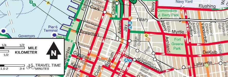
6 Bicycle circulation NYC defines 3 types of bicycle paths 1. Protected bicycle path, protected separation from cars (green). 2. Bicycle lane, marked separate lane (red). 3. Bicycle route, shared lanes (gold). See map next slide SITE Pedestrian circulation criteria, pedestrian systems, connections, paths, materials used, accessibility, lighting, signage. SITE 24

 straight line vs random vs diagonal vs curving rule of thumb one way sidewalks- 5' wide; collector walks")
7 Pedestrian circulation - space Average adult male 24 wide x 18 deep Easy movement requires 13 sq ft or a space of 4'-4" x 3 Crowd movement 7 sq ft or a space of 3'-6" x 2. More space is required on ramps and even more on stairs. SITE Pedestrian circulation - capacity varies with the characteristics of crowd and psychology (concert vs football) (cars vs subway) straight line vs random vs diagonal vs curving rule of thumb one way sidewalks- 5' wide; collector walks 6-10 or more SITE 25


8 Pedestrian circulation - direction People tend to walk in the line of least resistance, direct path more curvilinear than straight. SITE Pedestrian circulation - distance people willing to walk about 1/2 mile or about 12 minutes influences spacing of subway stops; size of university, commercial developments radius of 1/4 mile covers 125 acres SITE 26
 3.")
9 Pedestrian circulation - surfaces required characteristics: stable and firm; relatively smooth in texture, nonslip. 1. Soft (gravel, soil, soil and plants). 2. Variable (cobblestones, river stone, exposed aggregate, flagstone, sand-laid brick, wood decking) 3. Hard (asphalt, concrete, tile or brick in concrete SITE Walkway gradients Walks 1-5% (1:100 to1:20 gradient can be negotiated by handicapped but if 4-5% provide 5 level area every 100 feet; 3% slopes are preferred Ramps 5-8% 1:20 to 1:12 gradient SITE 27
ACCESSIBLE PUBLIC RIGHTS- OF-WAY FOR PEOPLE WITH DISABILITIES
 ACCESSIBLE PUBLIC RIGHTS- OF-WAY FOR PEOPLE WITH DISABILITIES Presented by Lois Chaplin Cornell Local Roads Program Bicycle and Pedestrian Specialist Paul Evans New York State DOT Landscape Architecture
ADA Design Overview. Section 2. ADA Design Overview. Pedestrian Access Routes. Pedestrian Access Routes. Overview
 ADA Design Overview Section 2 ADA Design Overview Overview Accessible Pedestrian Signals Alternate Fall, 2017 Ann Johnson, PE Services Brady Rutman, SRF Consulting Group 2 Pedestrian Access Route (PAR)
Standards vs. Guidelines. Public Right-of Way Accessibility Guidelines (PROWAG)
") www.access-board.gov Public Right-of Way Accessibility Guidelines (PROWAG) Juliet Shoultz, P.E Transportation Systems Engineer US Access Board Standards vs. Guidelines Guidelines are developed by the Access
www.access-board.gov Public Right-of Way Accessibility Guidelines (PROWAG) Juliet Shoultz, P.E Transportation Systems Engineer US Access Board Standards vs. Guidelines Guidelines are developed by the Access
Designing Pedestrian Facilities for Accessibility. Module 3 Curb Ramps & Blended Transitions
 Module 3 & Other Purpose: Allow pedestrians to transition between the street and sidewalks, islands, etc. Typically installed at: Intersections (1 ramp at each end of each crosswalk) Mid-block crossings
IMPLEMENTATION. PEDESTRIAN USERS (Continued /) A: Class 2 Pedestrian / Cycle Ways. Pedestrian and Cycle Ways:
 A: Class 2 Pedestrian / Cycle Ways. Pedestrian and Cycle Ways:") A: Class 2 Pedestrian / Cycle Ways PLAN VIEW Pedestrian and Cycle Ways: Layout and Geometry (Refer to A): Walkways and cycle to be provided adjacent to all Class 2 Roads (these facilities should always
A: Class 2 Pedestrian / Cycle Ways PLAN VIEW Pedestrian and Cycle Ways: Layout and Geometry (Refer to A): Walkways and cycle to be provided adjacent to all Class 2 Roads (these facilities should always
Niantic Center Elementary School
 Niantic Elementary School is located in the Northwest corner of the intersection of West Main Street and East Pattagansett Road, as so noted on the Facility Location Map. location Overview: The site is
Chapter 3 DESIGN SPECIFICATIONS
 Brampton PathWays Planning and Design Guidelines 27 Chapter 3 DESIGN SPECIFICATIONS 3.1 CLASS 1 MULTI-USE PATH Off-road multi-use trails are the backbone of the Brampton PathWays Network. They are typically
ROUNDABOUTS/TRAFFIC CIRCLES
 GENERAL 1. Description This standard identifies minimum requirements that shall be met for Roundabouts and Neighborhood Traffic Circles in the design and construction of elements for Arlington County Horizontal
IMPLEMENTATION. PEDESTRIAN USERS (Continued /) Building Frontages: A: Stair Applications. Geometry (Accessed from the Sidewalk) Refer to A:
 Building Frontages: A: Stair Applications. Geometry (Accessed from the Sidewalk) Refer to A:") A: Stair Applications Building Frontages: Geometry (Accessed from the Sidewalk) Refer to A: Ramps should be provided for disabled users at 1:12 (8.3%) gradient. Ramp rises should be stepped at 400mm intervals.
A: Stair Applications Building Frontages: Geometry (Accessed from the Sidewalk) Refer to A: Ramps should be provided for disabled users at 1:12 (8.3%) gradient. Ramp rises should be stepped at 400mm intervals.
CHAPTER 16 PEDESTRIAN FACILITIES DESIGN AND TECHNICAL CRITERIA TABLE OF CONTENTS
 CHAPTER 16 PEDESTRIAN FACILITIES DESIGN AND TECHNICAL CRITERIA TABLE OF CONTENTS Section Title Page 16.1 General... 16-1 16.1.1 AASHTO Reference... 16-1 16.1.2 ADA Requirements... 16-1 16.2 Sidewalks...
Sidewalk Accessibility Checklist
 Starting Address: Ending Address: Date: Sidewalk Accessibility Checklist Please indicate your experience with any barriers you encountered when using the sidewalks in your neighborhood. 1. Did you have
RC-67M has been updated to include more details to be consistent with both ADAAG and PROWAG. The following slides discusses the general notes found
 RC-67M has been updated to include more details to be consistent with both ADAAG and PROWAG. The following slides discusses the general notes found on Sheet 1. RC-67M note Construct curb ramps with a minimum
Accommodating Pedestrians in the Work Zone
 Accommodating Pedestrians in the Work Zone Guidance for Section C Plan Preparers Some impacts cannot be avoided and those impacts apply to residents, businesses, motorists, and pedestrians alike. However,
Appendix T CCMP TRAIL TRAFFIC & TRANSPORTATION DESIGN STANDARD
 Appendix T CCMP 3.3.4 TRAIL TRAFFIC & TRANSPORTATION DESIGN STANDARD 3.3.4 Trail Traffic and Transportation Design Multi-use trails have certain design standards, which vary depending on the agency that
PROCEDURE FOR ACCOMMODATING PEDESTRIANS IN WORK ZONES FOR CONSTRUCTION AND MAINTENANCE
 PROCEDURE FOR ACCOMMODATING PEDESTRIANS IN WORK ZONES FOR CONSTRUCTION AND MAINTENANCE A.1 STANDARD Measures shall be taken to accommodate pedestrian traffic through and/or around Work Zones for Construction
PENNSYLVANIA STANDARDS FOR RESIDENTIAL SITE DEVELOPMENT: APRIL 2007 CHAPTER 3: PEDESTRIAN AND BICYCLE CIRCULATION
 PENNSYLVANIA STANDARDS FOR RESIDENTIAL SITE DEVELOPMENT: APRIL 2007 CHAPTER 3: PEDESTRIAN AND BICYCLE CIRCULATION Chapter 3: Non-Vehicular Circulation Standards Contents ITEM PAGE # 3.0 OVERVIEW 4 3.1
Driveway Design Criteria
 Design Manual Chapter 5 - Roadway Design 5L - Access Management 5L-4 Driveway Design Criteria A. General For efficient and safe operations, access drives and minor public street intersections can be improved
Improvements Infrastructure Gap Assessment and Improvements Street Striping
 Infrastructure Project Proposal The federal-aid Safe Routes to School program funds infrastructure/engineering projects that fall into two categories: Design (available only to School Development Authority
Pine Point Study Committee. Report and Recommendations to Scarborough Town Council. December 10, 2009
 The Delphi Group, Inc Results through Alignment: Linking Direction, Capability & Commitment Pine Point Study Committee Report and Recommendations to Scarborough Town Council December 10, 2009 Committee
Designing Pedestrian Facilities for Accessibility. Module 8 Maintenance of Pedestrian Facilities and Alternate Pedestrian Access Routes in Work Zones
 Designing Pedestrian Facilities for Accessibility Module 8 Maintenance of Pedestrian Facilities and Alternate Pedestrian Access Routes in s Maintenance of Accessible Features Title II (28 CFR 35.133(a))
September 2008 REVISIONS (1) SYMMETRICAL VERTICAL CURVE EQUATIONS 12.5(12) VERTICAL CURVE COMPUTATIONS 12.5(14) TURNING LANE LENGTHS 15.
 SYMMETRICAL VERTICAL CURVE EQUATIONS 12.5(12) VERTICAL CURVE COMPUTATIONS 12.5(14) TURNING LANE LENGTHS 15.") September 2008 REVISIONS (1) CHAPTER 12 VERTICAL ALIGNMENTS SYMMETRICAL VERTICAL CURVE EQUATIONS 12.5(12) VERTICAL CURVE COMPUTATIONS 12.5(14) CHAPTER 15 INTERSECTIONS TURNING LANE LENGTHS 15.5(10) CHAPTER
September 2008 REVISIONS (1) CHAPTER 12 VERTICAL ALIGNMENTS SYMMETRICAL VERTICAL CURVE EQUATIONS 12.5(12) VERTICAL CURVE COMPUTATIONS 12.5(14) CHAPTER 15 INTERSECTIONS TURNING LANE LENGTHS 15.5(10) CHAPTER
This Chapter sets forth the minimum design, technical criteria and specifications to be used in the preparation of all roadway plans.
 4.1 GENERAL This Chapter sets forth the minimum design, technical criteria and specifications to be used in the preparation of all roadway plans. These Roadway Standards are for new construction and modification
ADA on Construction. Guidance for Section C Plan Preparers
 ADA on Construction Guidance for Section C Plan Preparers Some impacts cannot be avoided and those impacts apply to residents, businesses, motorists, and pedestrians alike. However, good planning can minimize
Re-Engineering Transport Designs for Safe and Universal Accessibility. Dr. Sewa Ram School of Planning and Architecture New Delhi
 Re-Engineering Transport Designs for Safe and Universal Accessibility Dr. Sewa Ram School of Planning and Architecture New Delhi Approach towards safe mobility What is Accessibility? Access +Ability Measuring
Roundabout Design Principles
 des Carrefours Giratoires Roundabout Design Principles NCLUG Roundabout Luncheon Tuesday, March 4, 2014 Prepared by: des Carrefours Agenda Giratoires Roundabout design process: Planning and Policy Lane
City of Roseville Section 13 Design Standards. _Bikeways January 2016 SECTION 13 BIKEWAYS
 SECTION 13 BIKEWAYS 13-1 GENERAL The City of Roseville bikeway standards are designed to insure that transportation and recreational bikeways are constructed in a manner that would provide a safe and comfortable
ACCESS, CIRCULATION AND PARKING
 TABLE OF CONTENTS SECTION 7 SECTION 7...1 ACCESS, CIRCULATION AND PARKING...1 7.1 INTRODUCTION...1 7.2 VEHICULAR ACCESS POINTS...1 7.2.1 Policy...1 7.2.2 Criteria...1 7.3 ROUNDABOUTS...2 7.3.1 Policy...2
ADA Training Standard Plans
 ADA Training Standard Plans SCREEN READABLE VERSION IS IN THE MAKING AND WILL BE MADE AVAILABLE SOON 2018 MnDOT 2 Standard Plans 2017 Overview Overview PROWAG and Curb Ramp Basics Curb Ramp Types ADA Curb
Right-of-Way Standards
 City of Ketchum P.O. Box 2315 480 East Ave. N. Ketchum, ID 83340 Right-of-Way Standards Effective July 2015 Introduction A public right-of-way is defined as improved or unimproved public property dedicated
DISTRIBUTION: Electronic Recipients List TRANSMITTAL LETTER NO. (17-01) MINNESOTA DEPARTMENT OF TRANSPORTATION. MANUAL: Road Design English Manual
 MINNESOTA DEPARTMENT OF TRANSPORTATION. MANUAL: Road Design English Manual") DISTRIBUTION: Electronic Recipients List MINNESOTA DEPARTMENT OF TRANSPORTATION DEVELOPED BY: Design Standards Unit ISSUED BY: Office of Project Management and Technical Support TRANSMITTAL LETTER NO.
DISTRIBUTION: Electronic Recipients List MINNESOTA DEPARTMENT OF TRANSPORTATION DEVELOPED BY: Design Standards Unit ISSUED BY: Office of Project Management and Technical Support TRANSMITTAL LETTER NO.
St. Francis Drive through the City of Santa Fe Corridor Study
 VII. ENGINEERING AND ENVIRONMENTAL EVALUATION TRAIL CONNECTIVITY In the southern portion of the Corridor there is a lack of a sidewalk, trail or bicycle facility within the right-ofway. However, the City
Right-of-Way Standards
 City of Ketchum P.O. Box 2315 480 East Ave. N. Ketchum, ID 83340 Right-of-Way Standards Effective July 2015 Introduction A public right-of-way is defined as improved or unimproved public property dedicated
Off-road Trails. Guidance
 Off-road Trails Off-road trails are shared use paths located on an independent alignment that provide two-way travel for people walking, bicycling, and other non-motorized users. Trails specifically along
COMPLETE STREETS DURING CONSTRUCTION
 COMPLETE STREETS DURING CONSTRUCTION MAINTAINING ACCESSIBILITY FOR ALL Presented by Robbie Burgess, P.E., PTOE Associate Principal Construction Services Manager Howard Stein Hudson rburgess@hshassoc.com
T10:2012 Site Category 1a) T10:2012 Site Category 1b) Railway Level Crossing Approach Traffic Signal Approach Event Code F Event Code E
 T10:2012 Site Category 1b) Railway Level Crossing Approach Traffic Signal Approach Event Code F Event Code E") T10:2012 Site Category 1a) Railway Level Crossing Approach Event Code F T10:2012 Site Category 1b) Traffic Signal Approach Event Code E Traffic signals Crosswalk T10:2012 Site Category 1c) Pedestrian Crossing
T10:2012 Site Category 1a) Railway Level Crossing Approach Event Code F T10:2012 Site Category 1b) Traffic Signal Approach Event Code E Traffic signals Crosswalk T10:2012 Site Category 1c) Pedestrian Crossing
ACCESSIBILITY STANDARDS for the BUILT ENVIRONMENT
 ACCESSIBILITY STANDARDS for the BUILT ENVIRONMENT City of Kitchener 200 King Street West, Kitchener, ON N2G 4G7 P. 519.741.2200 TTY. 1.866.969.2624 The City of Kitchener is committed to providing accessible
Complete Streets Design Considerations. Second Street Corridor Complete Streets Workshop and Assessment Manchester, NH April 26, 2013
 Complete Streets Design Considerations Second Street Corridor Complete Streets Workshop and Assessment Manchester, NH April 26, 2013 2 nd Street Existing Information Average Annual Daily Traffic Volumes
Field Design, Construction and inspection of ADA compliant Curb ramps. Mike Anderson City of Lee s Summit Construction Manager (816)
") Field Design, Construction and inspection of ADA compliant Curb ramps Mike Anderson City of Lee s Summit Construction Manager (816)969-1800 Today s Agenda Definitions & Acronyms Access Board vs. PROWAAC
Field Design, Construction and inspection of ADA compliant Curb ramps Mike Anderson City of Lee s Summit Construction Manager (816)969-1800 Today s Agenda Definitions & Acronyms Access Board vs. PROWAAC
CURBSIDE ACTIVITY DESIGN
 5 CURBSIDE ACTIVITY DESIGN This chapter provides design guidance for separated bike lanes adjacent to curbside activities including parking, loading and bus stops. Typical configurations are presented
Site 1180_042 Kekaulike Mall. Bikeshare Hawaii. Location: ewa side of Kekaulike Mall makai of Hotel Street. Power Source: solar
 Station located on the ewa side of Kekaulike Mall makai of Hotel Street 24 18 wide clear space remains for pedestrians and maintenance/emergency vehicles 40 Location: ewa side of Kekaulike Mall makai of
Town of Mooresville, North Carolina Neighborhood Traffic Calming and Control Device Policy
 Town of Mooresville, North Carolina Neighborhood Traffic Calming and Control Device Policy Adopted January 6, 2014 Town of Mooresville Development Services Department TOWN OF MOORESVILLE NEIGHBORHOOD TRAFFIC
Chapter BICYCLE PARKING REQUIREMENTS
 The following are proposed text changes to Chapter 17.117. Additions to the chapter are underlined; deletions are in strikeout. Chapter 17.117 BICYCLE PARKING REQUIREMENTS Sections: Article I. - General
Portland Peninsula Sidewalk and Ramp Inventory
 Portland Peninsula Sidewalk and Ramp Inventory Conducted June and July of 2008 By Anne Krikorian and Ryan Carmichael Performed under the authority of: Greater Portland Council of Governments And with the
Tacoma Streets 101. City of Tacoma - Citizen Neighborhood Street Improvement and Safety Task Force
 1 Tacoma Streets 101 2 Streets Maintenance Overview Type and amount of streets Condition and types of construction Maintenance and repair methods and costs Sample Project Philosophy/Selection Criteria
Section 4: Inventory Methodology and Findings
 Section 4: Inventory Methodology and Findings Section 4.1: Purpose and Summary of the Inventory Effort The purpose of the inventory is to show a baseline of existing pedestrian facilities in the City of
Bicycle and Pedestrian Advisory Committee (BPAC) November 21, 2013
 November 21, 2013") Bicycle and Pedestrian Advisory Committee (BPAC) November 21, 2013 OVERALL LAND USE CONCEPT Overall Broadway Valdez District: 95.5 acres (35.1 acres right-of ways + 60.4 acres developable land) Plan Subareas:
Bicycle and Pedestrian Advisory Committee (BPAC) November 21, 2013 OVERALL LAND USE CONCEPT Overall Broadway Valdez District: 95.5 acres (35.1 acres right-of ways + 60.4 acres developable land) Plan Subareas:
Ballston Station Multimodal Study WMATA and Arlington County. Meeting Minutes
 Date of Meeting: June 10, 2010 Location: Ballston Metrorail Station and NRECA Building 4301 Wilson Blvd, Arlington, VA Subject: Ballston Station Multimodal Study Stakeholder Meeting #1 Summary: This first
9 January 12, 2011 Public Hearing
 9 January 12, 2011 Public Hearing CITY OF VIRGINIA BEACH AMENDMENT TO LANDSCAPING GUIDE REQUEST: An Ordinance to amend the Landscape Guide by the inclusion of amendments pertaining to bicycle parking and
Steps to Conducting a Complete Streets Assessment
 Steps to Conducting a Complete Streets Assessment Familiarize yourself with Complete Streets Read through the Complete Streets Assessment Guidelines. This will give you an idea of what Complete Streets
Bases, Ballasts, and Paving
 Sections Included In This Standard: 1.1 Paving and Surfacing 1.2 Protection of the Work 1.3 Repair of Pavement 1.4 Pavement Marking 1.1 PAVING AND SURFACING A. DESIGN REQUIREMENTS 1. Applicable Design
Traffic Calming Policy Manual
 Traffic Calming Policy Manual What is Traffic Calming? Speeding and unsafe driving habits are a major concern throughout communities in the United States. The Town of Summerville is no exception with neighborhoods
Design Overview. Section 4 Standard Plans for Design. Pedestrian Access Routes. Pedestrian Access Routes. Overview. Cross Slope
 Design Overview Section 4 Standard Plans for Design Fall, 2017 Ann Johnson, PE Services Brady Rutman, SRF Consulting Group Overview Design Basics Recommendations: The Zone System Driveway Crossings Pedestrian
County of Greenville South Carolina. Traffic Calming Program Neighborhood Traffic Education Program and Speed Hump Program
 County of Greenville South Carolina Traffic Calming Program Neighborhood Traffic Education Program and Speed Hump Program (rev) August 2008 I. PURPOSE The potential negative impacts from vehicular traffic
Emerson Circle Entrance
 Emerson Circle Entrance It is not clear that there is a park in this location without a sign. Access from Emerson Circle: The present sloped granite curb does not provide access immediately at the park
PROWAG/ADAAG Standards Guidance For Temporary Pedestrian Access Route (TPAR) Facilities and Devices
 Facilities and Devices") INTRODUCTION: PROWAG/ADAAG Standards Guidance For Temporary Pedestrian Access Route (TPAR) Facilities and Devices Minnesota Department of Transportation DRAFT Document DRAFT This document was developed
INTRODUCTION: PROWAG/ADAAG Standards Guidance For Temporary Pedestrian Access Route (TPAR) Facilities and Devices Minnesota Department of Transportation DRAFT Document DRAFT This document was developed
County of Spartanburg South Carolina
 County of Spartanburg South Carolina Traffic Calming Program June 2012 (Revised/Program on Hold) PURPOSE The potential negative impacts from vehicular traffic on residential roads have been a longstanding
Segment Number Quick Pathways Accessibility Tool. Name of Street: Segment Identification:
 Quick Pathways Accessibility Tool Name of Street: Segment Identification: Date of survey: / / Name of surveyor(s): About this assessment: QPAT UIC Dept. of Disability and Human Development Page 1 of 15
Construction Specifications Manual
 Isle of Wight County Pedestrian and Bicycle Master Plan Construction Specifications Manual Adopted August 20, 2009 Introduction The Isle of Wight County Pedestrian and Bicycle Facilities Master Plan was
Derby Street. Project Updates. Salem, Massachusetts
 Derby Street Project Updates Salem, Massachusetts September 13, 2017 Project Limits Derby Street Project Objectives 1. Improve complete streets elements on Derby Street 2. Improve sidewalks on finger streets
RURAL HIGHWAY SHOULDERS THAT ACCOMMODATE BICYCLE AND PEDESTRIAN USE (TxDOT Project ) June 7, Presented by: Karen Dixon, Ph.D., P.E.
 June 7, Presented by: Karen Dixon, Ph.D., P.E.") RURAL HIGHWAY SHOULDERS THAT ACCOMMODATE BICYCLE AND PEDESTRIAN USE (TxDOT Project 0-6840) June 7, 2016 Presented by: Karen Dixon, Ph.D., P.E., TTI Team: Kay Fitzpatrick, Raul Avelar, & Subasish Das Project
RURAL HIGHWAY SHOULDERS THAT ACCOMMODATE BICYCLE AND PEDESTRIAN USE (TxDOT Project 0-6840) June 7, 2016 Presented by: Karen Dixon, Ph.D., P.E., TTI Team: Kay Fitzpatrick, Raul Avelar, & Subasish Das Project
S T A T I O N A R E A P L A N
 The Circulation and Access Plan describes vehicle, pedestrian, and transit improvements recommended within the Concept Plan. In order to create and sustain a vibrant business district that provides pedestrian-friendly
Traffic Impact Memorandum. May 22, 2018
 BISHOP PROFESSIONAL DEVELOPMENT BUILDING Proposed Land-use Change & Parking Modification 3601 SW 31st Street Topeka, Kansas 66614 CFS Project No. 185077 Traffic Impact Memorandum May 22, 2018 Prepared
Update to DOTD Roundabout Design Policy
 Update to DOTD Roundabout Design Policy Roundabout In Louisiana Louisiana has 18 roundabouts in operation and 53 proposed History EDSM s or Engineering Directives and Standards set DOTD policies, procedures,
TRAFFIC CALMING TOOLBOX
 TRAFFIC CALMING TOOLBOX Traffic control devices are those official signs and striping placed in the public right-of-way and recognized by the public such as STOP signs, curve warning signs, centerline
Shared Use Facili es. Mul -Use Trails. Chapter 3 Design Elements BICYCLE/PEDESTRIAN MULTI USE TRAILS
 Shared Use Facili es "Shared Use" or "Mul -Use" facili es are those where bicyclists share a facility with pedestrians and other non-motorized modes of travel such as equestrians, cross country skiers,
INDEX. Geometric Design Guide for Canadian Roads INDEX
 Acceleration lane, see Lanes, Acceleration Access, 8.1 Access Management and Functional Classification 8.2 Access Management by Design Classification 8.3 Access Configuration 8.4 Building Set-Back Guidelines
CITY OF ROCK HILL, SOUTH CAROLINA. Neighborhood Traffic Calming Program A Policy for Use of Traffic Calming on Local (Residential) Streets
 Streets") CITY OF ROCK HILL, SOUTH CAROLINA Neighborhood Traffic Calming Program A Policy for Use of Traffic Calming on Local (Residential) Streets I. Statement of Purpose: This program provides a process and a
CITY OF ROCK HILL, SOUTH CAROLINA Neighborhood Traffic Calming Program A Policy for Use of Traffic Calming on Local (Residential) Streets I. Statement of Purpose: This program provides a process and a
WHEREAS delivery trucks also pass through the Narrows, into the northern parking lot, to loading docks in the back of the building.
 CEDAR-ISLES-DEAN NEIGHBORHOOD ASSOCIATION ( CIDNA ) RESOLUTION OPPOSING A DRUG STORE DRIVE THRU, AND COMMENDING DORAN COMPANIES FOR PROPOSING MITIGATING AMENITIES INCLUDING NEW LANDSCAPING AND A DEDICATED
BP 344 IMPLEMENTING RULES AND REGULATIONS (IRR) AMENDMENTS MINIMUM REQUIREMENTS FOR ACCESSIBILITY
 AMENDMENTS MINIMUM REQUIREMENTS FOR ACCESSIBILITY") BP 344 IMPLEMENTING RULES AND REGULATIONS (IRR) AMENDMENTS MINIMUM REQUIREMENTS FOR ACCESSIBILITY A. GENERAL PROVISIONS 1. Accessible Ramps 1.1 Changes in level shall require a ramp except when served
BP 344 IMPLEMENTING RULES AND REGULATIONS (IRR) AMENDMENTS MINIMUM REQUIREMENTS FOR ACCESSIBILITY A. GENERAL PROVISIONS 1. Accessible Ramps 1.1 Changes in level shall require a ramp except when served
Engineering Your Community Safe
 Engineering Your Community Safe Andi Bill Transportation Information Center thanks its partners for their support and assistance National Traffic Safety Goal Reasonable goal? Who s Involved? What can you
Field guide for Accessible Public Rights-of-Way Edition
 Field guide for Accessible Public Rights-of-Way 2017 Edition CONTENTS PEDESTRIAN FACILITIES IN THE PUBLIC RIGHT-OF-WAY Pedestrian access routes 3 Components 3 Continuous width 3 Median and pedestrian refuge
Public Works Committee Meeting Richard E. Mastrangelo Council Chamber November 20, 2017
 Public Works Committee Meeting Richard E. Mastrangelo Council Chamber November 20, 2017 Purpose of Meeting Why are we here? Project Recap/Updates Project Limits/Segments Road Diet Concept Lessons Learned
Memorandum. Sunday, July 13, Saturday, July 19, 2014
 Memorandum To: David Lowin, Brooklyn Bridge Park Corporation From: Daniel Schack, AICP, PTP Date: Re: Brooklyn Bridge Park Pier 5/6 Loop Road Traffic Study Project No: 14-01-2407 At the request of Brooklyn
Chapter 6: Along the Street
 Chapter 6: Along the Street This section describes the types of infrastructure that should be in place along school routes to make walking and bicycling to school safer. Sidewalks In communities with sidewalks,
Lakeside Green Street Project Improvement. Public Works Committee February 27, 2018
 Lakeside Green Street Improvement Public Works Committee February 27, 2018 Construction of Lakeside Green Streets is currently underway Photo: Sergio Ruiz Photo: Sergio Ruiz 100% Do people biking on the
Chapter 5: Crossing the Street
 Chapter 5: Crossing the Street Whether walking or bicycling, a student s journey to school will more than likely require crossing one or more streets. Per the Safe Routes to School Guide, maintained by
CHAPTER 5: GENERAL SITE AND BUILDING ELEMENTS
 CHAPTER 5: GENERAL SITE AND BUILDING ELEMENTS 501 General 501.1 Scope. The provisions of Chapter 5 shall apply where required by Chapter 2 or where referenced by a requirement in this document. 502 Parking
Intersection Design. Leah Ness, Craig Hardy and Eric Sorensen
 Intersection Design Leah Ness, Craig Hardy and Eric Sorensen OVERVIEW TYPES OF INTERSECTIONS SCOPING COORDINATION INTERSECTION EVALUATION HORIZONTAL AND VERTICAL LAYOUTS DESIGN COORDINATION CONSTRUCTION
Pedestrian and Bicycle Design Guidelines
 REGIONAL BICYCLE AND PEDESTRIAN STUDY A Strategic Vision for Walking and Bicycling in the Greater Nashville Region Pedestrian and Bicycle Design Guidelines Technical Memorandum 8 November 2009 TABLE OF
Grade Separated Intersection
 Grade Separated Intersection Lecture Notes in Transportation Systems Engineering Prof. Tom V. Mathew Contents 1 Overview 1 2 Classification of Intersection 2 2.1 Grade Separated Intersection...........................
PEDESTRIAN CIRCULATION & STREETSCAPE DESIGN
 CHAPTER 4 Chapter 4 Pedestrian Circulation & Trails PEDESTRIAN CIRCULATION & STREETSCAPE DESIGN In recent years, the City has constructed new sidewalks and enhanced existing ones in the downtown with brick
ROADWAY AND PARKING DETAILS TYPICAL STREET SECTIONS PRINCIPAL ARTERIAL NOT TO SCALE
 NOTES: O:\Division Information\Engineering\Documents\Engineering and Construction\COMMERCE CITY\CAD files\2016 Updated Files\307-01 thru 307-09 (Roadway & Parking Typical Sections).dwg 6' SIDEWALK MAY
Muizenberg Accessibility: Removing barriers to public spaces.
 Muizenberg Accessibility: Removing barriers to public spaces. Refer to SANS 10400-S:2011 Edition 3 of the building code. Note: Facilities that are not in accordance with the requirements of this part of
APPENDIX G SIGNAGE AND STRIPING SUPPLEMENT
 APPENDIX G SIGNAGE AND STRIPING SUPPLEMENT DOUGLAS COUNTY SIGNAGE AND STRIPING SUPPLEMENT TO DOUGLAS COUNTY ROADWAY DESIGN & CONSTRUCTION STANDARDS UPDATED MAY 2018 TABLE OF CONTENTS 1.00: GENERAL REQUIREMENTS...
Anne Arundel County BICYCLE, PEDESTRIAN, TRANSIT ASSESSMENT GUIDELINES
 Anne Arundel County BICYCLE, PEDESTRIAN, TRANSIT ASSESSMENT GUIDELINES December 2018 TABLE OF CONTENTS I. Executive Summary 3 II. When Is A Bicycle Pedestrian Transit Assessment (BPTA) Required? 4 III.
Road Markings. Lecture Notes in Transportation Systems Engineering. Prof. Tom V. Mathew
 Road Markings Lecture Notes in Transportation Systems Engineering Prof. Tom V. Mathew 1 Overview The essential purpose of road markings is to guide and control traffic on a highway. They supplement the
Field guide for Accessible Public Rights-of-Way Edition
 Field guide for Accessible Public Rights-of-Way 2015 Edition BRIEFING MEMO SUBJECT: Department of Justice/Department of Transportation Joint Technical Assistance on Title II of the Americans with Disabilities
ADA TRANSITION PLAN 2013
 ADA TRANSITION PLAN 2013 TABLE OF CONTENTS Contents Introduction 1 Purpose 2 Identified Obstacles to the Public Right of Way 3 Criteria for Determining Impediments at Village Facilities 4 Removing Barriers
Chapter 33. Grade Separated Intersection Overview Classification of Intersection Grade Separated Intersection
 Chapter 33 Grade Separated Intersection 33.1 Overview An intersection is the area shared by the joining or crossing of two or more roads. Since the main function of an intersection is to enable the road
SRTS IMPLEMENTATION COSTS
 SRTS IMPLEMENTATION COSTS What Is a Estimate? A cost estimate establishes the anticipated budget required to implement the actions (the improvement projects and programs) identified in your School Travel
Cycle Track Design Best Practices Cycle Track Sections
 Design Best Practices Sections It is along street segments where the separation and protection methods of cycle tracks offer more comfort than conventional bicycle lanes, and are more attractive to a wide
TGSI Tactile Ground Surface Indicators
 TGSI Tactile Ground Surface Indicators Introduction: This Design Note, No 11, provides guidelines and requirements for the use and installation of Tactile Ground Surface Indicators (TGSI s). References
Paul Vraney Bureau of Project Development 02/11/2016
 Paul Vraney Bureau of Project Development 02/11/2016 ADA background & alterations definition Design considerations Provide sufficient layout data Curb ramp selection Maximum curb ramp and gutter slopes
5 CIRCULATION AND STREET DESIGN
 5 CIRCULATION AND STREET DESIGN This chapter describes circulation and streetscape improvements proposed for the Northwest Chico Specific Plan Area. It includes detailed design specifications for existing
ACCESSIBLE LOADING ZONES AND PROTECTED BIKE LANES: A UNIVERSAL DESIGN APPROACH. Accessibility Coalition Dec. 2016
 ACCESSIBLE LOADING ZONES AND PROTECTED BIKE LANES: A UNIVERSAL DESIGN APPROACH Accessibility Coalition Dec. 2016 A myth exists that only able-bodied individuals can ride bicycles. In reality, people with
City of Vallejo Traffic Calming Toolbox
 City of Vallejo Traffic Calming Toolbox June 1, 2013 Final Table of Contents Introduction... 1 Non-Physical Devices... 3 High-Visibility Crosswalk... 3 In Pavement Lighted Crosswalk... 4 Rapid Flashing
October 2004 REVISIONS (2) SUPERELEVATION DEVELOPMENT 11.3(2)
 SUPERELEVATION DEVELOPMENT 11.3(2)") October 2004 REVISIONS (2) Chapter 11 HORIZONTAL ALIGNMENT SUPERELEVATION DEVELOPMENT 11.3(2) Chapter 12 VERTICAL ALIGNMENT VERTICAL CURVES PASSING SIGHT DISTANCE 12.5(2) VERTICAL CURVES STOPPING SIGHT
October 2004 REVISIONS (2) Chapter 11 HORIZONTAL ALIGNMENT SUPERELEVATION DEVELOPMENT 11.3(2) Chapter 12 VERTICAL ALIGNMENT VERTICAL CURVES PASSING SIGHT DISTANCE 12.5(2) VERTICAL CURVES STOPPING SIGHT
Small. Regulation Reference: (see page 23 for link to the regulation)
") The Requirements of this Section apply to: Government of Ontario, Legislative Assembly, and Designated Public Sector Organizations Private / Not-for-Profit Sector Organizations Large Small Regulation Reference:
The Requirements of this Section apply to: Government of Ontario, Legislative Assembly, and Designated Public Sector Organizations Private / Not-for-Profit Sector Organizations Large Small Regulation Reference:
What Is a Complete Street?
 Session 5 Charleen Zimmer, AICP, Zan Associates May 5-7, 2010 What Is a Complete Street? May 2010 5-1 Not a Complete Street More of a Complete Street May 2010 5-2 Benefits of Complete Streets Safety for
Roadway Classification Design Standards and Policies. Pueblo, Colorado November, 2004
 Roadway Classification Design Standards and Policies Pueblo, Colorado November, 2004 Table of Contents Page Chapter 1. General Provisions 1.1 Jurisdiction 3 1.2 Purpose and Intent 3 1.3 Modification 3