Traffic Impact Memorandum. May 22, 2018
|
|
|
- Deborah Lindsey
- 5 years ago
- Views:
Transcription


1 BISHOP PROFESSIONAL DEVELOPMENT BUILDING Proposed Land-use Change & Parking Modification 3601 SW 31st Street Topeka, Kansas CFS Project No Traffic Impact Memorandum May 22, 2018 Prepared for: Topeka Public Schools, USD #501 Burnett Administrative Center 624 SW 24th Street Topeka, KS Prepared by: Cook, Flatt & Strobel Engineers, P.A Woodside Drive Topeka, Kansas
2 Table of Contents Review of Existing Site Conditions 2 Site s Trip Generation and Design Hour Volume Data 6 Trip Distribution and Traffic Assignment 10 Existing and Projected Traffic Volumes 15 Capacity Analysis 15 Traffic Accident History 15 Internal Circulation and Parking 15 Needs for Pedestrians, Bicyclists, and Public Transit Users 16 Traffic Operations and Geometric Improvements 16 Summary and Recommendations 16 Appendix I - Exhibit Map and ITE Trip Generation Pages 1

3 Review of Existing Site Conditions This Traffic Impact Memorandum for the proposed land-use change and parking modification for the Bishop Professional Development building at 3601 SW 31st Street, Topeka, Kansas, has been prepared at the request of Topeka Unified School District 501, in accordance with the City of Topeka's requirements. See Site Location Map below. The acre site, including the adjacent Maude Bishop Park, is proposed to undergo modifications to add a new driveway access to connect to SW 33rd Street to the south and additional parking. The existing building has a total floor square footage of 34,123 sqft. The school building was constructed in 1965 with additional classrooms added in Site Location Map, Topeka, Kansas N Topeka's School District, USD 501, is planning to reopen the recently closed Bishop Elementary School building at 3601 SW 31st Street, Topeka, Kansas as a new supplementary school 2

4 district office and teacher training facility called the Bishop Professional Development facility. This new facility will include small offices, a large gymnasium were teacher training events will take place, and a parking expansion to a total of 433 parking spaces (29 existing stalls plus 1 existing ADA accessible reserved stall plus 395 new regular stalls plus 8 new ADA accessible reserved stalls). The new site will supplement the current school district office, the Burnett Administrative Center, at 624 SW 24th Street, which has a staff consisting of business, communications, demographics, early childhood development, elementary learning, food, human resources, guidance and counseling, nursing, operations, school district attorney, special education, substitute, and superintendent services with 139 parking stalls with an additional 3 handicap reserved stalls. The new facility at 3601 SW 31st St will most likely have the same working hours as the Burnett Administrative Center, Monday through Friday from 7:30am to 4:30pm. Topeka Public Schools include 3 high schools, 6 middle schools, and 15 elementary schools with the last academic year enrollment of 14,044 students. Bishop Elementary was closed in summer of 2017 and the 311 enrolled students were moved to Jardine Middle School which was recently expanded to include space for an elementary school facility. Students included pre-kindergarten to 5th grade. The elementary employees that previously worked at the old Bishop Elementary included 26 teachers and 15 administration/support staff. Below is the image displaying the old attendance boundary of the closed Bishop Elementary School. Old Attendance Boundary for Bishop Elementary School (Closed) 3

5 The existing building has two northern driveways which form a circulation drive; the circulation drive is currently marked to travel in the counterclockwise direction only. The Northeast Driveway will be converted from an exit only driveway to provide both entry and exit access. There will be an extended 24 ft wide driveway connecting SW 31st Street to SW 33rd Street to improve internal circulation and reduce congestion with the parking lot. The site layout plan is shown below and includes a new dumpster location and truck loading location. Site Layout Plan N 4
6 Along the east side of the property is Maude Bishop Park which has a swing set, rotating platform, and fence backstop for baseball games. Park hours, 6:00am to 11:00pm, will not change as a result of the improvements. Park facility improvements are not included in this plan although the internal access drive and several parking spaces will be within the park parcel of land. The elementary school s basketball courts and playground equipment that is currently conflicting with the location of the planned parking will be removed. Area Street and Highway Network : The existing streets around the site include: SW 31st St Two-lane residential street. Speed limit of 30 mph. SW 33rd St Two-lane residential street. Speed limit of 30 mph. SW 30th Terr Two-lane residential street. Speed limit of 30 mph. SW Arnold Ave Two-lane residential street. Speed limit of 30 mph. SW Stone Ave Two-lane residential street. Speed limit of 30 mph. NW Driveway Northwest access. 20 ft wide entry and exit access point. NE Driveway Northeast access. 24 ft wide entry and exit access point. Several signs along the surrounding street network should be removed due to the changing land-use. On SW 31st Street, SW 33rd Street, and SW 30th Terrace, the posted speed limit of 20 mph (during school days from 8:00am to 9:00am and from 3:15pm to 4:15pm) signs should be removed as well as the end school zone signs. On Arnold Avenue, the electronic flashing posted speed limit of 20 mph (when flashing) signs and equipment should be removed as well as the end school zone signs. The two do not enter signs (during school days from 3:15pm to 4:15pm) on SW 31st Street should be removed as well as the turning restriction signs (during school days from 3:15pm to 4:15pm) on SW Arnold Avenue. The exit only do not enter sign at the northeast driveway should be removed. No parking signs, student loading/unloading signs, and school crossing signs should be removed if no longer applicable. Surrounding Land Uses and Building Density : For the site, two parcels are impacted by the improvements but only the old elementary parcel will have a change in land-use. The parcel ID for the closed elementary school is 7.92 acres and has a current land use of 6121-Elementary, and the parcel ID for the 5.51 acre Maude Bishop Park has a land use of 9910-Residential highest and best use. The building footprint is 34,123 sq ft for 5

7 the 7.92 acre parcel which yields a building density of approximately 10%. For the proposed change in land-use, the building footprint will not change. A Church is located to the south of the site on a 2.63 acre site. The parcel ID is which has a current land use of 6610-Church / place of worship. Surrounding the rest of the property is the Twilight Hills neighborhood in southwest Topeka. These properties have a current land-use of 1101-Single family residence (detached). See Parcel Map below. Parcel Map N 6

8 Water Conflicts : The FEMA FIRM Panel 20177C0213E indicates that the site is not located within the 100-year and 200-year flood limits. As the parking lot is expanded, the water conflicts will not be increased. Existing Relevant Transportation System Management Programs : Long Range Transportation Plan, April 2012, published by Metropolitan Topeka Planning Organization Topeka Pedestrian Master Plan 3. The Topeka Bikeways Master Plan Existing Alternative Transportation Mode Choices : There are sidewalks along both sides of SW 31st Street, SW 30th Terrace, and SW Arnold Avenue. SW 33rd Street has a sidewalk on the northern side of the street with a segment of sidewalk along the southern side of the street in front of the church. SW Stone Avenue has a sidewalk on the western side only. There are no plans to change sidewalks based on the changes to the parking lot. There are no bicycle lanes on any of the surrounding streets. There will be 23 bike parking spaces at the Bishop Professional Development building. The Topeka Bikeways Master Plan designates 33rd Street near the site as an on-street bikeway. Transit buses pass next to the site along Arnold Avenue using Route #29s. The transit routes will remain unchanged given the improvements to the project site. Bus Route Map N Anticipated Phasing and Timeline : Construction is anticipated to begin in the fall of 2018 and would take approximately 3 months. 7
9 Site s Trip Generation and Design Hour Volume Data Trip Generation Rates and Design Hour Volume Data : Trip generation calculations utilized the land use types categorized by the Institute of Transportation Engineer's Trip Generation Guidelines, 10 th Edition. The ITE Land Use categories used to estimate the traffic volumes anticipated to be generated by the site was School District Office (ITE Code 538). Since the site currently has no traffic except for use by the park users, the change in trips generated were only represented by additional traffic caused by the Bishop Professional Development building. The estimated number of trips generated by the buildings were calculated based on the 1000 sq ft of floor area (KSF). Copies of the ITE Trip Generation Manual pages are included in the appendix for reference purposes. The following table shows the parameters for measurement units, total trip generation rates for peak hour traffic volumes, and corresponding total vehicles for peak hour traffic at the site: ITE Traffic Generation Parameters Description (ITE Code) School District Office (ITE Code 538) Weekday Total Weekday In 50% Weekday Out 50% Peak Hour of Adjacent Street Traffic Peak Hour of Generator AM Peak Total AM Peak In 76% 67% AM Peak Out 24% 33% PM Peak Total PM Peak In 17% 40% PM Peak Out 83% 60% 8
10 Based on the higher peak hour of generator rates, trips were estimated for the new land-use. The following table shows the traffic generation given the square footage for peak hour traffic at the site: ITE Traffic Generation Volumes Description (ITE Code) Units School District Office (ITE Code 538) KSF (1000 sq ft) Expected Units Weekday Total 490 Weekday In 245 Weekday Out 245 AM Peak Total 84 AM Peak In 56 AM Peak Out 28 PM Peak Total 81 PM Peak In 32 PM Peak Out 49 Reductions for Pass-By and Diverted-Link Trips : The land-use of School District Office does not cause pass-by trips. No diverted-link analysis was done for this analysis. 9
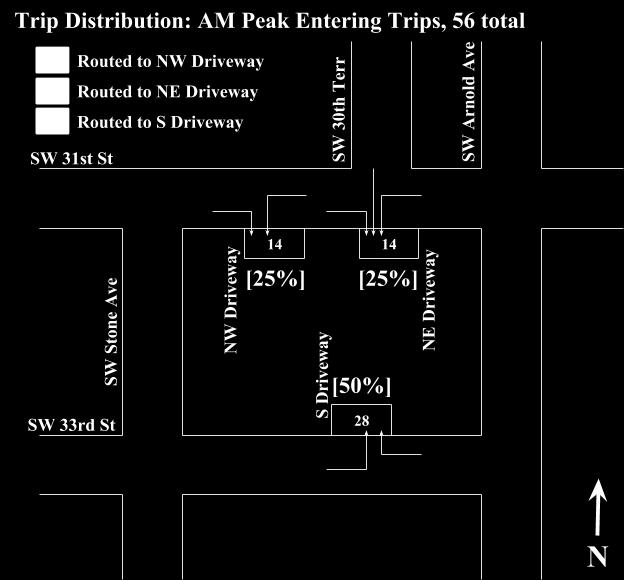
11 Trip Distribution and Traffic Assignment Trip Distribution and Traffic Assignment : Since this study did not meet the requirements for a full traffic impact study, traffic counts of the surrounding residential neighborhood streets were not taken. The new trips generated by the new land-use were all assigned to be newly created trips added into the roadway system at the surrounding origin and destination points. Trip distribution routes were estimated however the volume distribution of those trips could not determined without traffic counts. For the driveways, trips were distributed based on an assumption that 50% of vehicles would arrive and leave towards the city center and 50% of vehicles would arrive and leave towards the interstate. For exiting trips, since the 30 parking spaces to the northwest of the site represent 7% of the total available parking spaces, the Northwest Driveway was assigned 7% of exiting trips. For the following figures shown below, the distributed trips represent the amount of traffic caused by the new land-use. AM Peak Entering Trips, 56 total Northwest Driveway - 25% of generated trips, 14 trips Northeast Driveway - 25% of generated trips, 14 trips South Driveway - 50% of generated trips, 28 trips AM Peak Exiting Trips, 28 total Northwest Driveway - 7% of generated trips, 2 trips Northeast Driveway % of generated trips, 13 trips South Driveway % of generated trips, 13 trips PM Peak Entering Trips, 32 total Northwest Driveway - 25% of generated trips, 8 trips Northeast Driveway - 25% of generated trips, 8 trips South Driveway - 50% of generated trips, 16 trips PM Peak Exiting Trips, 49 total Northwest Driveway - 7% of generated trips, 3 trips Northeast Driveway % of generated trips, 23 trips South Driveway % of generated trips, 23 trips 10
12 11
13 12
14 13
15 14
16 Existing and Projected Traffic Volumes Existing Traffic Volumes : Existing traffic volumes were not collected as part of this study because the thresholds for a full traffic study were not met given the new land-use type. Projected Traffic Volumes : Since the number of trips attracted to the site will not increase or decrease with time but only changes if square footage would be altered, a growth rate was not used to project generated trips for future traffic conditions. Project traffic volumes for the surrounding street network were not included in this study. Capacity Analysis Capacity Analysis : A capacity analysis was not performed as part of this study. Traffic Accident History Traffic Accident History : A review of traffic crashes was not performed as part of this study. Internal Circulation and Parking Proposed Site Access : No changes are proposed for the Northwest Driveway. The Northeast Driveway will be expanded to 24 ft wide and will be changed from an exit only configuration to a entrance and exit access point. Internal Circulation : Internal circulation will remain counterclockwise for the northern circular loop. The new connecting driveway will link 31st Street to 33rd Street and will experience most of the internal traffic volume. There are no expected undue delays for entering or exiting the site. Delays for large events are not expected to be significant because of the connectivity provided by the surrounding local street network and the absence of any adjacent commercial property. Parking : Parking on the northwestern corner of the building will remain unchanged. The planned parking expansion will provide a total of 433 parking spaces (29 existing stalls plus 1 existing ADA accessible reserved stall plus 395 new regular stalls plus 8 new ADA accessible reserved stalls). For teacher training seminar events, the parking lot is expected to provide ample spaces. 15
17 Needs for Pedestrians, Bicyclists, and Public Transit Users Pedestrian Needs : A new pedestrian access will be provided connecting the southern side of the building to the southern parking lot. There are no necessary improvements for sidewalks surrounding the site. Bicyclist Needs : There are improvements necessary to accommodate bicyclists on the surrounding local streets. Bicycle parking for the facility will comply with the City of Topeka s requirements. The number of bike parking is equal to five percent of the total vehicle parking spaces. The on-site bike rack will provide spaces for 23 bikes. Public Transit User Needs : No improvements are necessary to accommodate public transit users. Traffic Operations and Geometric Improvements Traffic Operations and Geometric Improvements : No additional right-turn or left-turn auxiliary lanes are recommended due to the change in land-use. Summary and Recommendations Summary : This analysis addressed the street access and trips generated by the proposed land-use change for the Bishop Professional Development building at 3601 SW 31st Street, Topeka, Kansas. The expected delay caused by new vehicles entering and exiting the site is minimal due to the lack of adjacent conflicting commercial trip generators. Recommendation : The following recommendation is made for the property and the surrounding area: The proposed site plan includes a 24 ft wide connection drive from the Northeast Driveway to the new South Driveway, new parking for teacher events, and new locations for truck loading and the dumpster. These changes will be necessary for the new land-use type. Signage that was applicable to the old school land-use should be removed. 16
18 Appendix I - Exhibit Map and ITE Trip Generation Pages 17

19


20
21
22

23

24
25
SAFE ROUTES TO SCHOOL
 SAFE ROUTES TO SCHOOL Forest Ridge Elementary School Existing Conditions and ACTION PLAN > Oak Creek - Franklin Joint School District Table of Contents CONTEXT Enrollment Boundaries
Lake Whitney Elementary School
 Lake Whitney Elementary School SCHOOL ROUTE PLAN For LAKE WHITNEY ELEMENTARY SCHOOL LOCATION 18 ORANGE COUNTY Prepared for: ORANGE COUNTY SCHOOL ASSESSMENT PROGRAM ORANGE COUNTY PUBLIC WORKS Traffic Engineering
Transportation Impact Study for Abington Terrace
 Transportation Impact Study for Abington Terrace Abington Township, Montgomery County, PA Sandy A. Koza, P.E., PTOE PA PE License Number PE059911 Prepared by McMahon Associates, Inc. 425 Commerce Drive,
TRAFFIC IMPACT ANALYSIS
 TRAFFIC IMPACT ANALYSIS FOR THE CHAMPAIGN UNIT#4 SCHOOL DISTRICT PROPOSED HIGH SCHOOL (SPALDING PARK SITE) IN THE CITY OF CHAMPAIGN Final Report Champaign Urbana Urbanized Area Transportation Study 6/24/2014
Traffic Impact Analysis Chatham County Grocery Chatham County, NC
 Chatham County Grocery Chatham County, NC TABLE OF CONTENTS 1. INTRODUCTION... 1 1.1. Location and Study Area... 1 1.2. Proposed Land Use and Access... 2 1.3. Adjacent Land Uses... 2 1.4. Existing ways...
HENDERSON DEVELOPMENT 213, 217, 221, 221 ½, 223 HENDERSON AVENUE and 65 TEMPLETON STREET OTTAWA, ONTARIO TRANSPORTATION OVERVIEW.
 HENDERSON DEVELOPMENT 213, 217, 221, 221 ½, 223 HENDERSON AVENUE and 65 TEMPLETON STREET OTTAWA, ONTARIO TRANSPORTATION OVERVIEW Prepared for: 2294170 Ontario Inc. February 2, 2017 117-652 Report_1.doc
Trip Generation for an averaged sized elementary school in Provo, Utah
 Trip Generation for an averaged sized elementary school in Provo, Utah Brigham Young University s ITE student chapter conducted a Trip Generation Study to determine the number of trips generated by an
Meadow Woods Elementary School
 Drag and drop pic and stretch/crop to the limits of the blue rectangle (delete this text box) Meadow Woods Elementary School Drag and drop pic and stretch/crop to the limits of the blue rectangle (delete
Arlington Public Schools Thomas Jefferson Site Evaluation Transportation Networks. Thomas Jefferson Working Group Meeting #6 November 10, 2014
 Arlington Public Schools Thomas Jefferson Site Evaluation Transportation Networks Thomas Jefferson Working Group Meeting #6 November 10, 2014 2 3 INTRODUCTION 4 Goal of our work: Identify and assess multi-modal
TRAFFIC STUDY GUIDELINES Clarksville Street Department
 TRAFFIC STUDY GUIDELINES Clarksville Street Department 9/1/2009 Introduction Traffic studies are used to help the city determine potential impacts to the operation of the surrounding roadway network. Two
SAFE ROUTES TO SCHOOL
 SAFE ROUTES TO SCHOOL Edgewood Elementary School Existing Conditions and ACTION PLAN > Oak Creek - Franklin Joint School District Table of Contents CONTEXT Enrollment Boundaries Enrollment
MEDICAL/OFFICE BUILDING 1637 BANK STREET OTTAWA, ONTARIO TRANSPORTATION OVERVIEW. Prepared for:
 MEDICAL/OFFICE BUILDING 1637 BANK STREET OTTAWA, ONTARIO TRANSPORTATION OVERVIEW Prepared for: 2434984 Ontario Inc. 13-5510 Canotek Road Ottawa, Ontario K1J 9J5 June 4, 2015 115-613 Report_2.doc D. J.
I-35 COMAL COUNTY OPERATIONAL IMPROVEMENTS
 I- COMAL COUNTY OPERATIONAL IMPROVEMENTS OPEN HOUSE The environmental review, consultation, and other actions required by applicable Federal environmental laws for this project are being, or have been,
ALLEY 24 TRAFFIC STUDY
 ALLEY 24 TRAFFIC STUDY in City of Frostburg, Maryland January 2013 3566 Teays Valley Road Hurricane, WV Office: (304) 397-5508 www.denniscorporation.com Alley 24 Traffic Study January 2013 Frostburg, Maryland
TRANSPORTATION ANALYSIS REPORT US Route 6 Huron, Erie County, Ohio
 TRANSPORTATION ANALYSIS REPORT US Route 6 Huron, Erie County, Ohio December 12, 2012 Prepared for: The City of Huron 417 Main Huron, OH 44839 Providing Practical Experience Technical Excellence and Client
King Soopers #116 Thornton, Colorado
 Traffic Impact Study King Soopers #116 Thornton, Colorado Prepared for: Galloway & Company, Inc. 1.0 EXECUTIVE SUMMARY King Soopers #116, a grocery marketplace anchored commercial development, is proposed
Arlington s Master Transportation Plan
 Arlington s Master Transportation Plan The Master Transportation Plan (MTP) Adopted in eight parts Goals & Policies element and MTP Map adopted in 2007 Bicycle, Pedestrian and Demand and Systems Management
Traffic Impact Analysis Walton Acres at Riverwood Athletic Club Clayton, NC
 Traffic Impact Analysis Walton Acres at Riverwood Athletic Club Clayton, NC 1. TABLE OF CONTENTS INTRODUCTION...1 1.1. Site Location and Study Area...1 1.2. Proposed Land Use and Site Access...2 1.3.
Windy Ridge Elementary School
 Windy Ridge Elementary School SCHOOL ROUTE PLAN For WINDY RIDGE ELEMENTARY SCHOOL LOCATION 54 ORANGE COUNTY Prepared for: ORANGE COUNTY SCHOOL ASSESSMENT PROGRAM ORANGE COUNTY PUBLIC WORKS Traffic Engineering
Introduction...2. Multi-Modal Transportation Analysis TIA & Recommendations Design Proposal...3. Campus Pointe Development
 Table Of Contents...2...3...11...23...32...34 1 This study provides Midway Companies with a site plan and transportation analysis for, a proposed development near the Texas A&M University campus in College
5858 N COLLEGE, LLC N College Avenue Traffic Impact Study
 5858 N COLLEGE, LLC nue Traffic Impact Study August 22, 2016 Contents Traffic Impact Study Page Preparer Qualifications... 1 Introduction... 2 Existing Roadway Conditions... 5 Existing Traffic Conditions...
Traffic Impact Study. Westlake Elementary School Westlake, Ohio. TMS Engineers, Inc. June 5, 2017
 TMS Engineers, Inc. Traffic Impact Study Westlake Elementary School Westlake, Ohio June 5, 2017 Prepared for: Westlake City Schools - Board of Education 27200 Hilliard Boulevard Westlake, OH 44145 TRAFFIC
RCCG Jesus House. Preliminary Plan # TRAFFIC STUDY. Prepared for: RCCG Jesus House Montgomery County, Maryland
 TRAFFIC STUDY Prepared for: Montgomery County, Maryland Prepared by: SSSTS Consulting (410) 718-8660(410) 718-8660 Table of Contents SECTION 1 - INTRODUCTION... 1 SECTION 2 - EXISTING CONDITIONS... 4 Public
3.0 Future Conditions
 3.0 Future Conditions In order to be able to recommend appropriate improvements to the transportation system of the Town, it is important to first understand the nature and volume of traffic that is expected
Hidden Oaks Elementary School
 Hidden Oaks Elementary School SCHOOL ROUTE PLAN For HIDDEN OAKS ELEMENTARY SCHOOL LOCATION 13 ORANGE COUNTY Prepared for: ORANGE COUNTY SCHOOL ASSESSMENT PROGRAM ORANGE COUNTY PUBLIC WORKS Traffic Engineering
CITY OF OAKLAND. 27th Street Bikeway Feasibility and Design. Final Report (v3) March 23, Kimley-Horn and Associates, Inc.
 March 23, Kimley-Horn and Associates, Inc.") CITY OF OAKLAND 27th Street Bikeway Feasibility and Design Final Report (v3) March 23, 2007 PREPARED BY: Kimley-Horn and Associates, Inc. Table of Contents 1. Introduction 3 2. 27 th Street/Bay Place Corridor
CITY OF OAKLAND 27th Street Bikeway Feasibility and Design Final Report (v3) March 23, 2007 PREPARED BY: Kimley-Horn and Associates, Inc. Table of Contents 1. Introduction 3 2. 27 th Street/Bay Place Corridor
Bikeway action plan. Bicycle Friendly Community Workshop March 5, 2007 Rochester, MN
 Bikeway action plan Summary The was held on March 5, 2007 at the Rochester Mayo Civic Center. The workshop was hosted by Rochester-Olmsted County Planning Department in collaboration with the League of
THIS PAGE LEFT BLANK INTENTIONALLY
 GA SR 25 Spur at Canal Road Transportation Impact Analysis PREPARED FOR GLYNN COUNTY, GEORGIA 1725 Reynolds Street, Suite 300 Brunswick, Georgia 31520 PREPARED BY 217 Arrowhead Boulevard Suite 26 Jonesboro,
Simulation Analysis of Intersection Treatments for Cycle Tracks
 Abstract Simulation Analysis of Intersection Treatments for Cycle Tracks The increased use of cycle tracks also known as protected bike lanes has led to investigations of how to accommodate them at intersections.
City of Wayzata Comprehensive Plan 2030 Transportation Chapter: Appendix A
 A1. Functional Classification Table A-1 illustrates the Metropolitan Council s detailed criteria established for the functional classification of roadways within the Twin Cities Metropolitan Area. Table
See Figure 38, Existing Nonmotorized Connections.
 Nonmotorized Connections Existing Nonmotorized Connections Pedestrian, vehicle and bike traffic access and movements are confined primarily to Penny Drive on campus. Due to the steep slope along the length
Community Bicycle Planning
 Community Bicycle Planning City of Mentor s Bicycle Facility Plan Allen E. Pennington, P.E. Civil Engineer - Traffic Office of the Mentor City Engineer Why has Mentor participated in bicycle planning?
NJDOT Complete Streets Checklist
 Background The New Jersey Department of Transportation s Complete Streets Policy promotes a comprehensive, integrated, connected multi-modal network by providing connections to bicycling and walking trip
A plan for improved motor vehicle access on Railroad Avenue in Provincetown
 A plan for improved motor vehicle access on Railroad Avenue in Provincetown February 2011 A plan for improved motor vehicle access on Railroad Avenue in Provincetown INTRODUCTION AND PROBLEM IDENTIFICATION
Street / Bob Billings Parkway Lawrence, Kansas CFS Project No
 Drive Improvements 6 th Street to 15 th Street / Bob Billings Parkway Lawrence, Kansas 6644 CFS Project No. 15-56 Traffic Impact Study July 15, 15 Prepared for: City of Lawrence Public Works Department
TRAFFIC MANAGEMENT PLAN
 292 84 140440 TRAFFIC MANAGEMENT PLAN The purpose of the Traffic Management Plan (TMP) is to have established procedures for traffic flow and circulation around the elementary school related to student
CHAPTER 4 TRANSPORTATION IMPACT STUDY TABLE OF CONTENTS
 CHAPTER 4 TRANSPORTATION IMPACT STUDY TABLE OF CONTENTS Section Title Page 4.1 Introduction... 4-1 4.1.1 General... 4-1 4.1.2 Applicant Responsibility... 4-1 4.1.3 Capacity and Safety Issues... 4-1 A.
CHAPTER 3. Transportation and Circulation
 CHAPTER 3 Transportation and Circulation 3.0 TRANSPORTATION AND CIRCULATION This chapter evaluates traffic circulation, transit, parking, pedestrian, bicycle, and rail operational conditions in the Project
Wesbrook Place Traffic Analysis of Redistributed Dwelling Units
 Wesbrook Place Traffic Analysis of Redistributed Dwelling Units 1 Summary This report presents an analysis of the changes in traffic volumes in the Wesbrook Place neighbourhood associated with a redistribution
OFFICE/RETAIL DEVELOPMENT 1625 BANK STREET OTTAWA, ONTARIO TRANSPORTATION BRIEF. Prepared for: Canada Inc.
 OFFICE/RETAIL DEVELOPMENT 1625 BANK STREET OTTAWA, ONTARIO TRANSPORTATION BRIEF Prepared for: 9402209 Canada Inc. December 15, 2015 115-625 Report_2.doc D. J. Halpenny & Associates Ltd. Consulting Transportation
Comments EXECUTIVE SUMMARY
 Comments 1. Under any Alternatives, MCDOT should provide better at-grade pedestrian crossing of Georgia Avenue and Forest Glen Road, including improved crosswalks with wider medians and adequate signal
NM-POLICY 1: Improve service levels, participation, and options for non-motorized transportation modes throughout the County.
 Transportation PRINCE WILLIAM COUNTY 2008 COMPREHENSIVE PLAN NON-MOTORIZED PLAN CONTENTS Goals, Policies, and Action Strategies Table 4 (Bike Facility Classifications and Descriptions) Table 5 (Bike Facility
Access Management Regulations and Standards
 Access Management Regulations and Standards January 2014 Efficient highway operation Reasonable property access Concept of Access Management The way to manage access to land development while preserving
Implementing the Three Es of School Zone Traffic Calming
 Implementing the Three Es of School Zone Traffic Calming Use this evaluation tool as a guide to analyze the specific safety needs of your school. SCHOOL PROFILE School Name: School District: Address: Phone
D.13 Transportation and Traffic
 This section addresses transportation and traffic issues and impacts related to the Proposed Project. Section D.13.1 provides a description of the affected environment for the Proposed Project. Applicable
1609 E. FRANKLIN STREET HOTEL TRAFFIC IMPACT STUDY EXECUTIVE SUMMARY
 1609 E. FRANKLIN STREET HOTEL TRAFFIC IMPACT STUDY EXECUTIVE SUMMARY Prepared for: The Town of Chapel Hill Public Works Department Traffic Engineering Division Prepared by: HNTB North Carolina, PC 343
TRAFFIC IMPACT STUDY And A TRAFFIC SIGNAL WARRANT ANALYSIS FOR A SENIOR LIVING AND APARTMENT DEVELOPMENT
 TRAFFIC IMPACT STUDY And A TRAFFIC SIGNAL WARRANT ANALYSIS FOR A SENIOR LIVING AND APARTMENT DEVELOPMENT DEERFIELD TOWNSHIP, WARREN COUNTY, OHIO Nantucket Circle and Montgomery Road () Prepared for: ODLE
Access Management Regulations and Standards
 Access Management Regulations and Standards Efficient highway operation Reasonable property access Concept of Access Management The way to manage access to land development while simultaneously preserving
ADOT Statewide Bicycle and Pedestrian Program Summary of Phase IV Activities APPENDIX B PEDESTRIAN DEMAND INDEX
 ADOT Statewide Bicycle and Pedestrian Program Summary of Activities APPENDIX B PEDESTRIAN DEMAND INDEX May 24, 2009 Pedestrian Demand Index for State Highway Facilities Revised: May 29, 2007 Introduction
MEETING FACILITY 2901 GIBFORD DRIVE CITY OF OTTAWA TRANSPORTATION BRIEF. Prepared for: Holiday Inn Express 2881 Gibford Drive Ottawa, ON K1V 2L9
 MEETING FACILITY 2901 GIBFORD DRIVE CITY OF OTTAWA TRANSPORTATION BRIEF Prepared for: Holiday Inn Express 2881 Gibford Drive Ottawa, ON K1V 2L9 December 18, 2012 112-566 Brief_1.doc D. J. Halpenny & Associates
West Dimond Blvd Upgrade Jodhpur Street to Sand Lake Road
 West Dimond Blvd Jodhpur St to Sand Lake CSS Transportation Project Summary Municipality of Anchorage Project # 05 005 Project Manager: John Smith, P.E. (MOA PM&E) Project Administrator: Julie Makela,
MEMORANDUM. Sutter Street Bicycle Lanes, Stockton, CA SF
 MEMORANDUM Date: To: From: Subject: PURPOSE Anthony J. Lopes, Siegfried Engineering Christine Carey & Matthew Ridgway, Fehr & Peers Sutter Street Bicycle Lanes, Stockton, CA SF09-0468 The City of Stockton
5.0 Roadway System Plan
 Southwest Boise Transportation Study Page 16 5.0 Roadway System Plan The Roadway System Plan outlines roadway improvements in the Initial Study Area. It forecasts future deficiencies on the arterial system,
Corpus Christi Metropolitan Transportation Plan Fiscal Year Introduction:
 Introduction: The Safe, Accountable, Flexible, Efficient Transportation Equity Act: A Legacy for Users (SAFETEA-LU) has continued the efforts started through the Intermodal Surface Transportation Efficiency
TRAFFIC ACTION PLAN. North Central Neighborhood CITY OF SAN MATEO
 TRAFFIC ACTION PLAN North Central Neighborhood CITY OF SAN MATEO Draft February 2017 Table of Contents Introduction... 1 The Traffic Forum Process... 4 Neighborhood Traffic Issues... 6 Neighborhood Recommendations
INDUSTRIAL BUILDING 1660 COMSTOCK ROAD CITY OF OTTAWA TRANSPORTATION OVERVIEW. Prepared for:
 INDUSTRIAL BUILDING 1660 COMSTOCK ROAD CITY OF OTTAWA TRANSPORTATION OVERVIEW Prepared for: Simluc Contractors Limited 2550 Blackwell Street, Ottawa K1B 5R1 October 18, 2013 113-584 Overview_1.doc D. J.
Roadway Classification Design Standards and Policies. Pueblo, Colorado November, 2004
 Roadway Classification Design Standards and Policies Pueblo, Colorado November, 2004 Table of Contents Page Chapter 1. General Provisions 1.1 Jurisdiction 3 1.2 Purpose and Intent 3 1.3 Modification 3
Gene Dillon Elementary School Traffic Study Division Street Site
 To: From: Dr. James Hess, Superintendent Jordan Schwarze, PE, Senior Engineer Matt Pacyna, PE, Senior Associate Date: March 30, 2016 Subject: Gene Dillon Elementary School Traffic Study reet Site Memorandum
Durrance Elementary School
 Durrance Elementary School SCHOOL ROUTE PLAN For DURRANCE ELEMENTARY SCHOOL LOCATION 9 ORANGE COUNTY Prepared for: ORANGE COUNTY SCHOOL ASSESSMENT PROGRAM ORANGE COUNTY PUBLIC WORKS Traffic Engineering
CITY OF OAK CREEK SAFE ROUTES TO SCHOOL ACTION PLAN. East Middle School
 CITY OF OAK CREEK SAFE ROUTES TO SCHOOL ACTION PLAN East Middle School CITY OF OAK CREEK SAFE ROUTES TO SCHOOL ACTION PLAN East Middle School Why Safe Routes to School? Safe Routes to School ( SRTS ) is
LSC TRANSPORTATION CONSULTANTS, INC. 516 North Tejon Street Colorado Springs, CO (719) FAX (719)
 FAX (719)") LSC TRANSPORTATION CONSULTANTS, INC. 516 North Tejon Street Colorado Springs, CO 80903 (719) 633-2868 FAX (719) 633-5430 E-mail: lsc@lsccs.com May 15, 2009 Mr. Davis Farrar Western Slope Consulting, LLC
LSC TRANSPORTATION CONSULTANTS, INC. 516 North Tejon Street Colorado Springs, CO 80903 (719) 633-2868 FAX (719) 633-5430 E-mail: lsc@lsccs.com May 15, 2009 Mr. Davis Farrar Western Slope Consulting, LLC
Orange Center Elementary School
 Drag and drop pic and stretch/crop to the limits of the blue rectangle (delete this text box) Orange Center Elementary School Drag and drop pic and stretch/crop to the limits of the blue rectangle (delete
Report. Typical Sections. City of Middleton, WI
 Report Typical Sections City of Middleton, WI December 2006 Report for City of Middleton, Wisconsin Typical Sections repared by: Traffic Associates LLC and STRAND ASSOCIATES, INC. 910 West Wingra Drive
Frequently Asked Questions
 Frequently Asked Questions Business US 190 in Copperas Cove From Avenue D to Constitution Drive What is access management? A. Access Management is a growing effort by government agencies to improve how
Complete Street Analysis of a Road Diet: Orange Grove Boulevard, Pasadena, CA
 Complete Street Analysis of a Road Diet: Orange Grove Boulevard, Pasadena, CA Aaron Elias, Bill Cisco Abstract As part of evaluating the feasibility of a road diet on Orange Grove Boulevard in Pasadena,
INDUSTRIAL BUILDING 3009 HAWTHORNE ROAD CITY OF OTTAWA TRANSPORTATION OVERVIEW REVISED. Prepared for: Canada Inc.
 INDUSTRIAL BUILDING 3009 HAWTHORNE ROAD CITY OF OTTAWA TRANSPORTATION OVERVIEW REVISED Prepared for: 7849648 Canada Inc. Octiober 1, 2015 114-598 Overview_2.doc D. J. Halpenny & Associates Ltd. Consulting
SECTION 1 - TRAFFIC PLANNING
 SECTION 1 - TRAFFIC PLANNING 1.1 TRAFFIC OPERATIONS 1.1.1 Roadway Functional Classification The Multnomah County Comprehensive Framework Plan s Policy 34: Trafficways and the Functional Classification
Chapter 3.3 Horizon Elementary School. Volusia County MPO. June 2009
 Chapter 3.3 Horizon Elementary School Port Orange, FL Volusia County MPO June 2009 Volusia County MPO School Bicycle and Pedestrian Review Study, Phase 3C School Summary Horizon Elementary School is located
TOWN OF CHAPEL HILL POLICY AND PROCEDURES FOR TRAFFIC CALMING MEASURES
 TOWN OF CHAPEL HILL POLICY AND PROCEDURES FOR TRAFFIC CALMING MEASURES (Adopted by the Town Council on June 30, 2004) (Revised December 6, 2010) (Revised February 8, 2016) POLICY AND PROCEDURES FOR TRAFFIC
Traffic Impact Study WestBranch Residential Development Davidson, NC March 2016
 Traffic Impact Study WestBranch Residential Development Davidson, NC March 216 TRAFFIC IMPACT STUDY FOR THE WestBranch Residential Development LOCATED IN DAVIDSON, NC Prepared For: Lennar Carolinas, LLC
Existing Transportation System
 < Open for Additional Text Transportation System Existing Transportation System This section describes vehicular transportation associated with Children s. transportation are described in a separate section
Overview. Illinois Bike Summit IDOT Complete Streets Policy Presentation. What is a Complete Street? And why build them? And why build them?
 Overview Illinois Bike Summit IDOT Complete Streets Policy Presentation Aren Kriks, P.E. District One Bicycle Coordinator and Bureau of Programming Project Engineer History of Complete Streets IDOT Policy
Magnolia Place. Traffic Impact Analysis. Prepared for: City of San Mateo. Prepared by: Hexagon Transportation Consultants, Inc.
 Magnolia Place Traffic Impact Analysis Prepared for: City of San Mateo Prepared by: Hexagon Transportation Consultants, Inc. Updated January 4, 2010 Table of Contents 1. Introduction...1 2. Existing Conditions...6
TRAFFIC IMPACT STUDY. Creekside Thornton, Colorado. For. August 2015 November 2015 Revised: August Prepared for:
 TRAFFIC IMPACT STUDY For Creekside Thornton, Colorado August 215 November 215 Revised: August 216 Prepared for: Jansen Strawn Consulting Engineers 45 West 2 nd Avenue Denver, Colorado 8223 Prepared by:
Clyde Brown Elementary School Millis, MA
 Clyde Brown Elementary School Millis, MA Transportation Assessment August 8, 2017 Prepared for: Tappe Architects Six Edgerly Place Boston, MA 02116 Submitted by: Nitsch Engineering 2 Center Plaza, Suite
Route 7 Corridor Study
 Route 7 Corridor Study Executive Summary Study Area The following report analyzes a segment of the Virginia State Route 7 corridor. The corridor study area, spanning over 5 miles in length, is a multi
City of Gainesville Transportation/Roadway Needs PROJECT SUMMARY
 A1 Roadway Resurfacing $23,846,000 TYPE: Preservation of existing system Roadway resurfacing A2 Signal Replacement $6,000,000 TYPE: Preservation of existing system Replace traffic signals. B1 W 6th St
Gateway Transportation Study
 Gateway Transportation Study Amherst, Massachusetts SUBMITTED TO University of Massachusetts Amherst Town of Amherst SUBMITTED BY Vanasse Hangen Brustlin, Inc. Watertown, Massachusetts March 213 Back of
4.0 TRAFFIC IMPACT STUDIES
 SECTION 4 4.0 TRAFFIC IMPACT STUDIES 4.1 TRAFFIC IMPACT STUDY REQUIREMENTS The City has established Traffic Impact Study (TIS) requirements for the purpose of ensuring that both the quantitative and qualitative
HILTON GARDEN INN HOTEL HOTEL EXPANSION 2400 ALERT ROAD, OTTAWA TRANSPORTATION BRIEF. Prepared for:
 HILTON GARDEN INN HOTEL HOTEL EXPANSION 2400 ALERT ROAD, OTTAWA TRANSPORTATION BRIEF Prepared for: Bona Building & Management Co. Ltd. Place Vanier, 333 North River Road Vanier, Ontario K1L 8B9 October
Employment 8,881 17,975 9,094. Households 18,990 31,936 12,946
 This section describes the future transportation environment of the UW Tacoma campus and surrounding area. A description of the future conditions on campus in terms of the street system, traffic and intersection
This Chapter sets forth the minimum design, technical criteria and specifications to be used in the preparation of all roadway plans.
 4.1 GENERAL This Chapter sets forth the minimum design, technical criteria and specifications to be used in the preparation of all roadway plans. These Roadway Standards are for new construction and modification
COMMERCIAL DEVELOPMENT 2015 ROBERTSON ROAD OTTAWA, ONTARIO TRANSPORTATION BRIEF. Prepared for:
 COMMERCIAL DEVELOPMENT 2015 ROBERTSON ROAD OTTAWA, ONTARIO TRANSPORTATION BRIEF Prepared for: First Bay Properties Inc. 311 Richmond Road, Suite 203 Ottawa, ON K1Z 6X3 August 8, 2017 117-663 Brief_1.doc
INTRODUCTION THOROUGHFARE SYSTEM CLASSIFICATIONS
 INTRODUCTION The thoroughfare plan will assist public officials in the development of a specialized system for efficient and safe movement of vehicular traffic while minimizing potential conflicts with
Walton Acres at Riverwood Athletic Club Clayton, North Carolina
 9. CONCLUSIONS This Traffic Impact Analysis Update was conducted to determine the potential traffic impacts of the proposed Walton Acres at Riverwood Athletic Club residential development, located east
RESOLUTION NO ?? A RESOLUTION OF THE CITY OF NEPTUNE BEACH ADOPTING A COMPLETE STREETS POLICY
 RESOLUTION NO. 2018-?? A RESOLUTION OF THE CITY OF NEPTUNE BEACH ADOPTING A COMPLETE STREETS POLICY WHEREAS, safe, convenient, and accessible transportation for all users is a priority of the City of Neptune
THE LANDMARK AT TALBOT PARK
 TRAFFIC IMPACT STUDY FOR THE LANDMARK AT TALBOT PARK IN NORFOLK, VA INTERMODAL ENGINEERING, P.C. OCTOBER, 200 The Landmark at Talbot Park is a proposed redevelopment of the existing apartments along the
Caltrans Sloat Boulevard Pedestrian Safety Project Response to Community Questions, Comments & Concerns
 Caltrans Sloat Boulevard Pedestrian Safety Project Response to Community Questions, Comments & Concerns Revised: May 10, 2016 The California Department of Transportation (Caltrans) is planning various
STANLEY STREET December 19, 2017
 STANLEY STREET December 19, 2017 Welcome Mike Wiza, Mayor Scott Beduhn, Director of Public Works Agenda 1. Introduction 2. Existing Roadway Conditions 3. Current Alternative Improvements 4. Summary of
Site Improvements
 Sections Included In This Standard: 1.1 Bicycle Facilities 1.2 Guardrails 1.3 Parking Bumpers 1.4 Traffic Signage 1.5 Traffic Signals 1.6 Traffic Impact Studies 1.7 Vision Triangle 1.8 Bus Stop Shelters
Peer Review of Highlands Neighborhood Traffic and Pedestrian Safety Plan
 FINAL REPORT March 14, 2017 Prepared for: Ada County Highway District Prepared by: SIX MILE ENGINEERING, PA Executive Summary The (Highlands Safety Plan) developed by the Ada County Highway District (ACHD)
To: ACHD Commissioners and Director 3/14/2017. Peer Review of Highlands Neighborhood Traffic and Pedestrian Safety Plan Information Briefing
 Paul Woods, President Rebecca W. Arnold, Vice President Kent Goldthorpe, Commissioner Sara M. Baker, Commissioner Jim D. Hansen, Commissioner MEMORANDUM Engineering To: ACHD Commissioners and Director
APPENDIX A: Complete Streets Checklist DRAFT NOVEMBER 2016
 APPENDIX A: Complete Streets Checklist DRAFT NOVEMBER 2016 Complete Streets Checklist MetroPlan Orlando s Complete Streets Checklist is an internal planning tool for staff to further implementation of
Off-road Trails. Guidance
 Off-road Trails Off-road trails are shared use paths located on an independent alignment that provide two-way travel for people walking, bicycling, and other non-motorized users. Trails specifically along
Sebastopol Charter School Traffic Management Plan
 Sebastopol Charter School The serves as the working document in support of these essential goals: to ensure the safety and efficiency of student arrival to and departure from school to ensure the safety
Abingdon Elementary School School Transportation Report
 Abingdon Elementary School School Transportation Report May 2015 Prepared for Arlington Public Schools by Toole Design Group, LLC 1 CONTENTS Executive Summary... 3 Introduction... 7 Existing Conditions
P HA Transportation Consultants
 Attachment F P HA Transportation Consultants 2711 Stuart Street Berkeley CA 94705 Phone {510) 848-92.33 Web www.pangho.com September 8, 2017 Newell Arnerich AD Architects Via email:newell@adarch.com Dear
July 5, Arthur R. Ware, Jr. Elementary School 2017 Safe Routes to School Walkabout Report
 July 5, 2017 Arthur R. Ware, Jr. Elementary School 2017 Safe Routes to School Walkabout Report 1 Walkabout Report Introduction On April 28, 2017, City, School, and SAWMPO staff met to conduct a Safe Routes
Downtown Naples Mobility and Connectivity Study. Naples City Council Presentation January 2017
 Downtown Naples Mobility and Connectivity Study Naples City Council Presentation January 2017 Agenda 1. Introduction 2. Scope Review 3. Project Schedule 4. Existing Conditions 5. Public Charrette 6. Mobility
Appendix T CCMP TRAIL TRAFFIC & TRANSPORTATION DESIGN STANDARD
 Appendix T CCMP 3.3.4 TRAIL TRAFFIC & TRANSPORTATION DESIGN STANDARD 3.3.4 Trail Traffic and Transportation Design Multi-use trails have certain design standards, which vary depending on the agency that