MEETING FACILITY 2901 GIBFORD DRIVE CITY OF OTTAWA TRANSPORTATION BRIEF. Prepared for: Holiday Inn Express 2881 Gibford Drive Ottawa, ON K1V 2L9
|
|
|
- Griselda Morris
- 5 years ago
- Views:
Transcription
1 MEETING FACILITY 2901 GIBFORD DRIVE CITY OF OTTAWA TRANSPORTATION BRIEF Prepared for: Holiday Inn Express 2881 Gibford Drive Ottawa, ON K1V 2L9 December 18, Brief_1.doc D. J. Halpenny & Associates Ltd. Consulting Transportation Engineers P.O. Box 774, Manotick, ON K4M 1A7 Tel (613) Fax (613)
2 TABLE OF CONTENTS PAGE 1. INTRODUCTION Scope of Work ROADWAY NETWORK PROPOSED DEVELOPMENT Trip Generation Trip Distribution TRANSPORTATION IMPACT Background Traffic Volumes Total Traffic Volumes Traffic Analysis Site Circulation of Traffic Pedestrian, Cycling, and Transit Facilities FINDINGS AND RECOMMENDATIONS APPENDIX LIST OF FIGURES 1.1 SITE LOCATION PLAN YEAR 2011 PEAK AM AND PM HOUR TRAFFIC COUNTS CONCEPTUAL SITE PLAN PEAK AM AND PM HOUR SITE GENERATED TRIPS YEAR 2019 PEAK AM AND PM HOUR BACKGROUND TRAFFIC YEAR 2019 PEAK AM AND PM HOUR TOTAL TRAFFIC LIST OF TABLES 3.1 PEAK HOUR SITE TRIPS GENERATED SOUTH ACCESS/GIBFORD LoS & 95 th Percentile Queue WEST ACCESS/GIBFORD LoS & 95 th Percentile Queue GIBFORD/UPLANDS LoS & 95 th Percentile Queue HUNT CLUB/GIBFORD LoS & 95 th Percentile Queue... 15
3 MEETING FACILITY 2901 GIBFORD DRIVE, OTTAWA TRANSPORTATION BRIEF 1. INTRODUCTION The owners of land at 2901 Gibford Drive have proposed the construction of a which would provide meeting rooms to the two adjacent hotels and the general public. The site is located south of Hunt Club Road and west of Uplands Drive adjacent to the existing Holiday Inn Express & Suites hotel. The will be constructed on currently vacant land which is approximately 1.0 hectares (2.47 acres) in size. The will consist of a large meeting hall which can be partitioned off into three smaller meeting rooms. The site will have two access points onto Gibford Drive and a possible connection to both the Holiday Inn Express & Suites hotel and the Hampton Inn hotel. The Hampton Inn hotel is expected to be completed and open to guests by the fall of The location of the site is shown in Figure 1.1. As part of the Site Plan Application, City of Ottawa staff has requested a be prepared which would assess the impact of the proposed on the surrounding roads. D. J. Halpenny & Associates Ltd. has been engaged by the owner of the property to prepare the for the facility. 1.1 Scope of Work The scope of the was determined during discussions with City of Ottawa staff. The study area will comprise of the following intersections: 1) South Access onto Gibford Drive at the south end of the site 2) West Access onto Gibford Drive at Dean Martin Crescent 3) Gibford Drive and Uplands Drive 4) Hunt Club Road and Gibford Drive The analysis will be conducted for the peak traffic period. The peak time period of the adjacent roads was determined from City of Ottawa traffic counts at the Hunt Club/Paul Anka intersection to occur during the weekday peak AM and PM hours. The would experience the peak time period of trips entering and exiting the site during the same peak time as the adjacent roads. Other peak times of the facilities would occur on weekends at approximately 7:00 PM which would coincide with the off peak time period of the adjacent roads. The traffic analysis will therefore be conducted during the weekday peak AM and PM hours of the adjacent roads.
4 2 FIGURE 1.1 SITE LOCATION PLAN
5 3 The study will examine the operation of the intersections for the existing 2011 traffic counts prior to the construction of the, and for the expected traffic volumes at the year 2019 which represents five years beyond the construction of the facility. 2. ROADWAY NETWORK The will have two accesses onto Gibford Drive. Gibford Drive is a two lane urban local street which connects to Hunt Club Road and Uplands Drive. The road has a sidewalk on the east side of the road between the existing Holiday Inn Express hotel and Hunt Club Road. The speed limit is unposted at 50 km./h. The west access to the site would be onto Gibford Drive across from Dean Martin Crescent. Dean Martin Crescent is a two lane urban local street connecting Gibford Drive to Paul Anka Drive. There are no sidewalks, cycling facilities, or a posted speed limit along the road. The will have indirect access to Hunt Club Road (Ottawa Road 32). Hunt Club Road is an east-west road which is identified as an arterial road in the Ottawa 20/20 Transportation Master Plan. Hunt Club Road is a four lane divided road with bicycle lanes and pedestrian sidewalks along both sides of the roadway. The road has a posted speed limit of 60 km./h. The east limit of the site will back onto Uplands Drive. Uplands Drive is identified as a collector road with a two lane rural cross section. The road has a posted speed limit of 50 km,/h. with no sidewalks or cycling facilities along the road within the vicinity of Gibford Drive. The West Access to the site would be onto Gibford Drive at the Gibford/Dean Martin intersection. The intersection is currently a T intersection with Gibford Drive forming the northbound and southbound approaches, and Dean Martin Crescent the eastbound stop controlled approach. All approaches comprise of one lane with shares turning movements. The intersection of Gibford Drive and Uplands Drive is a T intersection with Uplands Drive forming the northbound and southbound approaches, and Gibford Drive the eastbound approach. The intersection is controlled by a stop sign at the eastbound Gibford Drive approach. The intersection has the following lane configuration: Northbound Uplands Approach - Southbound Uplands Approach - Eastbound Gibford Approach - One shared left/through lane One shared through/right lane One shared left/right turn lane The intersection of Hunt Club Road and Gibford Drive is a T intersection with Gibford Drive forming the northbound approach and Hunt Club Road the eastbound and westbound approaches. The intersection is controlled by a stop sign at the northbound Gibford Drive approach, with a centre median along Hunt Club Road which restricts turning movements to right-in/right-out to and from Gibford Drive. The intersection has the following lane configuration:
6 4 Northbound Gibford Approach - Eastbound Hunt Club Approach - Westbound Hunt Club Approach - One right turn lane One through lane One shared through/right lane Two through lanes Figure 2.1 shows the weekday peak AM and PM hour traffic counts taken by the City of Ottawa at the intersection of Hunt Club Road and Paul Anka Drive on June 15, To supplement the City of Ottawa counts, traffic counts were taken by the consultant at the Gibford/Uplands intersection on July 27, 2011, and at the Gibford/Dean Martin intersection and access to the Holiday Inn Express on August 3, PROPOSED DEVELOPMENT The proposed would have a municipal address of 2901 Gibford Drive and is located at the northwest corner of the intersection of Gibford Drive and Uplands Drive. The lands for the facility are vacant and are approximately 1.0 hectares (2.47 acres) in size. The site is currently zoned IL[1488] H(14) which will support the construction of the. Lands in the vicinity of the site are the Holiday Inn Express & Suites hotel which is adjacent to the north limit of the site, and the future Hampton Inn hotel which is expected to be constructed and open to guests by the year South of the site is the Park n Fly airport parking lot, and along the west limit of Gibford Drive is vacant land where residential development is proposed. Residential development is planned and currently under construction along Dean Martin Crescent which is west of the site. The will comprise of three meeting rooms with a total area of 1,416.4 m 2 (15,241 ft 2 ). The three rooms are divided by partitions which can be moved to combine rooms. In addition to the three meeting rooms the facility will also include a pre-function lobby, kitchen and storage facilities, washrooms, and offices and mechanical rooms, for a total floor area of approximately 3,300 m 2. The site would contain 155 parking spaces which include 6 barrier free spaces. The site would have two access points onto Gibford Drive. The West Access is at the Gibford/Dean Martin intersection with the access forming the new westbound approach to the existing intersection. The second access is the South Access which is located along the south property limit close to the. With the associated with the Holiday Inn Express & Suites and Hampton Inn, the Site Plan provides a possible internal parking lot connection between the facility and the parking lots at the two hotels. Discussions with the owners and operators of the have determined that the facility is typically expected to be open between the hours of 9:00 AM and 4:00 PM during the week, and between 7:00 PM and 11:00 PM during the weekend. Although the facility has the capacity for 500 people, during the week the facility would handle meetings which would typically have approximately 100 people. Since the facility is associated with the Holiday Inn Express & Suites and Hampton Inn hotels and all other hotels in the area have their own meeting
7 5 FIGURE 2.1 YEAR 2011 PEAK AM AND PM HOUR TRAFFIC COUNTS
8 6 rooms, the facility would largely cater to the guests of the Holiday Inn and Hampton hotels. Figure 3.1 shows a conceptual site plan of the development. The is expected to be completed and open to guests by the year Trip Generation The study has determined the number of site generated trips for the peak time period of the adjacent roads. Traffic counts taken by the City of Ottawa at the Hunt Club/Paul Anka intersection has determined the peak hours of traffic to occur during the weekday between 7:15 and 8:15 AM and between 5:00 and 6:00 PM. Since the Institute of Transportation Engineers (ITE) document, Trip Generation, 8 th Edition, does not have a category for a similar type of meeting facility, the study has determined the expected number of site trips from discussion with the owner on the expected operation of the facility. The study analysis has used the following assumptions: 1. The would operate during the weekday hours of 9:00 AM and 4:00 PM and would be open during the peak hours of the adjacent roads. 2. During the weekday peak hours the facility would have 100 people at the facility. All attendees would arrive and depart during the peak hours examined in the study. 3. With the facility associated with the Holiday Inn Express & Suites and Hampton Inn hotels, operators say that 90 percent of the trips are expected to be internal. The study has assumed that 80 percent of the trips would be external with 1 person per vehicle. No adjustments were applied for public transit or taxi use. 4. The analysis has assumed a 90/10 split of trips entering and exiting the site during the peak AM hour and a 10/90 split during the peak PM hour. Peak AM and PM Hour Site Trips = % external trips = 20 Trips/hour Table 3.1 shows the expected site generated trips from the which would occur during the weekday peak AM and PM hours. TABLE 3.1 PEAK HOUR SITE TRIPS GENERATED UNIT TYPE WEEKDAY PEAK AM HR. WEEKDAY PEAK PM HR. TOTAL ENTER EXIT TOTAL ENTER EXIT (90%) 2 (10%) 20 2 (10%) 18 (90%)

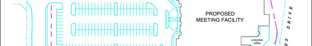
9 7 FIGURE 3.1 CONCEPTUAL SITE PLAN
10 8 3.2 Trip Distribution The distribution of site generated trips was determined from the existing peak hour traffic counts along Hunt Club Road which were compiled from the counts at the Hunt Club/Paul Anka intersection. The counts showed that traffic eastbound and westbound along Hunt Club Road were approximately equal during peak hours. The analysis has therefore proportioned the site trips at a 50/50 distribution east and west along Hunt Club Road. Few trips would use Uplands Drive and Lester Road to access the site, therefore the analysis did not distribute trips south of the site along Uplands Drive. Figure 3.2 shows the expected distribution of site generated trips during the weekday peak AM and PM hours. 4. TRANSPORTATION IMPACT The study will examine the operation of the two site access points onto Gibford Drive and the Hunt Club/Gibford and Gibford/Uplands intersections. The study will analyze the operation of the intersections for the existing traffic counts and for the future 2019 traffic volumes (five years beyond completion of construction) which include the expected trips from the. The analysis will use the Highway Capacity Software, Release 5.6, which utilizes the intersection capacity analysis procedure as documented in the 2010 Highway Capacity Manual. For unsignalized intersections, the level of service of each lane movement is determined as a function of the delay of vehicles at the approach. The following relates the level of service of each lane movement with the expected delay at the approach. LEVEL OF SERVICE DELAY Level of Service A 0-10 sec./vehicle Little or No Delay Level of Service B >10-15 sec./vehicle Short Traffic Delays Level of Service C >15-25 sec./vehicle Average Traffic Delays Level of Service D >25-35 sec./vehicle Long Traffic Delays Level of Service E >35-50 sec./vehicle Very Long Traffic Delays Level of Service F >50 sec./vehicle Extreme Delays Demand Exceeds Capacity The expected length of queue at the critical lane movements for an unsignalized intersection was determined by the calculation of the 95 th percentile queue at the lane approach. The 95 th percentile queue length is the calculated 95 th greatest queue length out of 100 occurrences at a movement during a 15-minute peak period. The 95 th percentile queue length is a function of the capacity of a movement and the total expected traffic, with the calculated value determining the magnitude of the queue by representing the queue length as fractions of vehicles. 4.1 Background Traffic Volumes The background traffic volumes used in the study analysis represents the future volume of traffic which would not include the proposed. Traffic counts taken by the City of Ottawa between the years July 22, 1999 and June 15, 2011 at the Hunt Club/Paul Anka intersection has shown that the peak AM and PM hour traffic has reduced or stayed approximately the same over the twelve year time period with the exception of the eastbound Hunt Club Road peak AM hour traffic which showed an annual increase of 1.4 percent. The
11 9 FIGURE 3.2 PEAK AM AND PM HOUR SITE GENERATED TRIPS
12 10 opening of the Strandherd/Earl Armstrong Bridge in the fall of 2013 is expected to further reduce traffic volumes along Hunt Club Road. The study has therefore increased the background traffic volumes at an annual rate of 2.0 percent between the 2011 existing traffic counts and 2019 traffic volumes. In addition to the increase in traffic from development outside the study area, the 2019 background traffic will also include trips from proposed development in the vicinity of the site. The Hampton Inn along the north side of the site which proposes 98 guest rooms will be open in 2013 and will utilize the. A 140 unit retirement home with 27 townhouse units is proposed at 700 Hunt Club Road across from the site. The development would have the main access onto Dean Martin Crescent, with the front entrance and visitor parking accessing onto Gibford Drive. A second development is proposed and is currently under construction at 101 Dean Martin Crescent. This development would include 22 townhouses and 6 semidetached homes, with access onto Dean Martin Crescent. Expected trips from these developments were calculated using the statistical data published in the ITE document, Trip Generation, 8 th Edition. This future development traffic was added to the year 2019 background traffic. The expected 2019 peak AM and PM hour background traffic volumes which do not include the trips generated by the are shown in Figure Total Traffic Volumes The expected total 2019 weekday peak AM and PM hour traffic volumes were determined by the addition of the expected site generated trips shown in Figure 3.2, and the 2019 background traffic shown in Figures 4.1. The result is the expected 2019 peak AM and PM hour total traffic volumes shown in Figure Traffic Analysis The report has examined the operation of the two site access points onto Gibford Drive along with the operation of the Gibford/Uplands and Hunt Club/Gibford intersections for the existing traffic counts taken in 2011 and the expected future total traffic volumes at the year The study has assumed that all of the trips to/from the site occurred during the peak AM and PM hour of the adjacent roads. The results of the analysis are discussed in detail in the following sections: South Access and Gibford Drive Intersection The Site Plan proposes a new site access along the south side of the site onto Gibford Drive. The access would be a T intersection with Gibford Drive forming the eastbound and westbound approaches, and the site access the stop controlled southbound approach. The access is located approximately 100 metres west of the Gibford/Uplands intersection, and approximately 105 metres east from the point where Gibford Drive changes direction from an east-west to northsouth orientation. The site access will have a width of 6.7 metres and comprises of one lane entering and one lane exiting the site.
13 11 FIGURE 4.1 YEAR 2019 PEAK AM AND PM HOUR BACKGROUND TRAFFIC
14 12 FIGURE 4.2 YEAR 2019 PEAK AM AND PM HOUR TOTAL TRAFFIC
15 13 An operational analysis was conducted for the expected 2019 total traffic volumes at the new South Access to the site. The analysis determined that the eastbound Gibford Drive left/through movement would function at a Level of Service (LoS) A during both the weekday peak AM and PM hours, and the southbound site exit shared left/right turning movement would also function at a LoS A during the peak AM and PM hours. A 95 th percentile queue of 0.03 vehicles occurred at the southbound movement during the peak PM hour time period. Table 4.1 summarizes the findings of the operational analysis with the analysis work sheets provided in the Appendix as Exhibit 1 for the 2019 peak AM hour and Exhibit 2 for the peak PM hour. TABLE 4.1 SOUTH ACCESS/GIBFORD LoS & 95 th Percentile Queue Intersection Approach WEEKDAY PEAK AM HOUR YEAR (2019) WEEKDAY PEAK PM HOUR YEAR (2019) LoS Q 95 (Veh.) LoS Q 95 (Veh.) EB Left/Through Gibford (A) (0.00) (A) (0.00) SB Left/Right South Access (A) (0.00) (A) (0.03) West Access and Gibford Drive Intersection The West Access to the site is located at the west end of the site and will form the new west approach to the existing intersection of Gibford Drive and Dean Martin Crescent. Gibford Drive would form the northbound and southbound approaches, Dean Martin Crescent the eastbound approach, and the site access the westbound approach as shown in Figure 3.1. The West Access is a private driveway which is offset from Dean Martin Crescent by approximately 5.2 metres. Due to the location of the property line between the site and the Holiday Inn Express & Suites hotel, the private access cannot be aligned with Dean Martin Crescent because of the location requirements of the City of Ottawa Private Approach By-law. The site access would 6.7 metres in width and would have one lane entering and a shared left/through/right lane exiting the site. All approaches to the intersection would comprise of one lane at the approach with no exclusive turn lanes. The intersection would be a two-way stop controlled intersection with stop signs at the eastbound Dean Martin Crescent and westbound site exit approaches. At the year 2011 the intersection was a T intersection with the westbound Dean Martin Crescent approach controlled by a stop sign. The 2011 operational analysis determined that the northbound Gibford left/through approach and eastbound Dean Martin left/right approach would both function at a LoS A during the peak AM and PM hours. Table 4.2 summarizes the operation of the intersection with the analysis sheets provided as Exhibit 3 for the peak AM hour and Exhibit 4 for the peak PM hour.
16 14 At the year 2019, the West Access to the would form the westbound stop controlled approach to the intersection. The operational analysis determined that all approaches would function at a LoS A during both the 2019 peak AM and PM hours. The 95 th percentile queue was calculated as 0.13 vehicles at the eastbound Dean Martin Crescent approach during the peak AM and PM hours, and 0.06 vehicles at the northbound Gibford Drive approach during the peak AM hour. Table 4.2 summarizes the operation of the intersection with the analysis sheets provided as Exhibit 5 and 6. TABLE 4.2 WEST ACCESS (DEAN MARTIN)/GIBFORD LoS & 95 th Percentile Queue Intersection Approach WEEKDAY PEAK AM HOUR YEAR 2011 (2019) WEEKDAY PEAK PM HOUR YEAR 2011 (2019) LoS Q 95 (Veh.) LoS Q 95 (Veh.) NB Left/Through/Right Gibford A (A) 0.04 (0.06) A (A) 0.03 (0.05) SB Left/Through/Right Gibford * A (A) - (0.02) A (A) - (0.00) WB Left/Through/Right Access * A (A) - (0.00) A (A) - (0.03) EB Left/Through/Right Dean Martin A (A) 0.05 (0.13) A (A) 0.05 (0.13) * The westbound West Access and southbound Gibford Drive approaches were not examined in the 2011 analysis prior to the construction of the. Gibford Drive and Uplands Drive Intersection The Gibford/Uplands intersection is located approximately 100 metres east of the site s South Access. The intersection of Gibford Drive and Uplands Drive is a T intersection with a stop sign at the eastbound Gibford Drive approach. All intersection approaches comprise of one lane with no exclusive turn lanes. The operational analysis determined that the northbound Uplands Drive left/through movement would function at a LoS A during the peak AM and PM hours, and the eastbound Gibford Drive left/right turn movement at a LoS B during the peak AM and PM hours. Table 4.3 summarizes the operation of the intersection with the analysis sheets provided in Exhibits 7 and Exhibit 8. For the expected total traffic volumes at the year 2019, the northbound Uplands Drive approach would continue to function at a LoS A and the eastbound Gibford Drive approach at a LoS B during both the peak AM and PM hours. The northbound Gibford Drive approach would experience a 95 th percentile queue of 0.9 vehicles and the eastbound Gibford Drive approach a queue of 0.43 vehicles during the weekday peak PM hour. The analysis sheets are provided in the Appendix as Exhibits 9 and 10.
17 15 TABLE 4.3 GIBFORD/UPLANDS LoS & 95 th Percentile Queue Intersection Approach WEEKDAY PEAK AM HOUR YEAR 2011 (2019) WEEKDAY PEAK PM HOUR YEAR 2011 (2019) LoS Q 95 (Veh.) LoS Q 95 (Veh.) NB Left/Through Uplands A (A) 0.01 (0.03) A (A) 0.05 (0.09) EB Left/Right Gibford B (B) 0.07 (0.12) B (B) 0.19 (0.43) Hunt Club Road and Gibford Drive Intersection The intersection of Gibford Drive and Hunt Club Road is a T intersection with Gibford Drive forming the northbound right turn movement. The continuous centre median along Hunt Club Road restricts the intersection to right-in/right-out turning movements. The operational analysis utilizing the existing 2011 traffic counts determined that the northbound Gibford right turn movement would function at a LoS B during the peak AM and PM hour with a 95 th percentile queue of 0.15 vehicles during the peak AM hour. Table 4.4 summarizes the operation of the intersection with the analysis sheets provided as Exhibits 11 and 12. TABLE 4.3 HUNT CLUB/GIBFORD LoS & 95 th Percentile Queue Intersection Approach WEEKDAY PEAK AM HOUR YEAR 2011 (2019) WEEKDAY PEAK PM HOUR YEAR 2011 (2019) LoS Q 95 (Veh.) LoS Q 95 (Veh.) NB Right Gibford B (C) 0.15 (0.53) B (C) 0.10 (0.48) With the increasing background traffic volumes at the year 2019, the northbound Gibford Drive right turn movement would function at a LoS C during both the peak AM and PM hours. The movement would experience a 95 th percentile queue of 0.53 vehicles during the peak AM hour. Table 4.4 summarizes the operation of the intersection, with the analysis sheets provided as Exhibit 13 and Exhibit 14.
18 Site Circulation of Traffic The site contains 155 parking spaces and has two access points onto Gibford Derive. The Site Plan shows a possible internal link to both the Holiday Inn Express & Suites hotel and Hampton Inn hotel which are associated with the. The plan shows a good circulation of traffic throughout the site. The Site Plan shows a clear throat distance onto Gibford Drive (local street) of approximately 12 metres at each access point which would satisfy the requirements of the Transportation Association of Canada (TAC) publication, Geometric Design Guide for Canadian Roads. The operational analysis determined the 95 th percentile queue at the year 2019 to be 0.03 vehicles during the peak PM hour at both the West and South accesses. 4.5 Pedestrian, Cycling, and Transit Facilities The Site Plan shows a sidewalk along Gibford Drive across the frontage of the site. The sidewalk will connect to the sidewalk across the frontage of the Holiday Inn site which connects to the sidewalk on Hunt Club Road. Guests of the hotel are not expected to arrive by bicycles or public transit, but these modes of transportation may be used by employees. Hunt Club Road has cycling lanes along both sides of the road which link to the cycling network. The site will provide bicycle storage racks close to the facility. Public transit exists along Hunt Club Road with two regular route and two peak hour routes available. One regular route and one limited schedule route travel along Uplands Drive past the site with bus stops in close proximity of the facility. 5. FINDINGS AND RECOMMENDATIONS The owners of land at 2901 Gibford Drive have proposed the construction of a which would provide meeting space for the adjacent Holiday Inn Express & Suites and future Hampton Inn hotels. The facilities would also be open for other private meetings or events. The would provide three meeting rooms and 155 parking spaces. The facility is expected to be constructed by the year Discussions with City of Ottawa staff have determined that the Site Plan Application would require only a report due to the expected low number of new site generated trips. The study analysis has examined the surrounding roads and intersections for the impact of the site during the weekday peak AM and PM hour of the adjacent roads at the time period of five years beyond the opening of the facility. The findings and recommendations of the study are summarized in the following: 1) The operating hours of the are from 9:00 AM to 4:00 PM on weekdays, and from 7:00 PM to 11:00 PM on weekends. Discussions with the owners on the operation of the facility have determined that during the weekdays the facility would
19 17 typically have 100 attendees. Most of the attendees would be staying at either the Holiday Inn Express & Suites or Hampton Inn hotels. The study has assumed that 80 percent of the trips would be internal to the facility and the Holiday Inn and Hampton Inn hotels, and that all of the site trips would be entering and exiting the facility during the weekday peak AM and PM hours of the adjacent roads. The analysis determined that the would generate 20 new trips onto the adjacent roads during the peak AM hour and 20 trips during the peak PM hour. 2) The site would have two access points onto Gibford Drive. The first is the South Access which is located at the south limit of the site. The access would be 6.7 metres in width and would comprise of one lane entering the site and one lane exiting the site. The access would operate at a good level of service at the year 2019 with no modifications required to Gibford Avenue. The second access is the West Access which would form the westbound stop controlled approach to the existing intersection of Gibford Drive and Dean Martin Crescent. The intersection would operate at a good level of service for the expected 2019 traffic with no modifications required with the exception of the 6.7 metre private driveway forming the westbound intersection approach. 3) The Gibford/Uplands and Hunt Club/Gibford intersections would operate at a good level of service for the total 2019 peak AM and PM hour traffic volumes. There would be no requirement for modifications to the intersections due to the construction of the Meeting Facility. 4) The Site Plan shows the construction of a pedestrian sidewalk along the frontage of the site on the east/north side of Gibford Drive. The sidewalk would connect to the existing sidewalk on the east side of Gibford Drive at the Holiday Inn Express & Suites hotel, and would continue along the east and north side of Gibford Drive to Uplands Drive. 5) A Check List is provided in the Appendix as Exhibit 15. Prepared by: David J. Halpenny, P. Eng.
20 18 APPENDIX OPERATIONAL ANALYSIS WORK SHEETS TRANSPORTATION BRIEF CHECK LIST
21 19 EXHIBIT 1 YEAR 2019 PEAK AM HOUR ANALYSIS South Access/Gibford HCS+: Unsignalized Intersections Release 5.6 TWO-WAY STOP CONTROL SUMMARY Analysis Time Period: Peak AM Hour Intersection: Site Access/Gibford Analysis Year: Year 2019 Project ID: Gibford Drive East/West Street: Gibford Drive North/South Street: Site Access Intersection Orientation: EW Study period (hrs): 0.25 Vehicle Volumes and Adjustments Major Street: Approach Eastbound Westbound Movement Volume Peak-Hour Factor, PHF Hourly Flow Rate, HFR Percent Heavy Vehicles Median Type/Storage Undivided / RT Channelized? Lanes Configuration LT TR Upstream Signal? No No Minor Street: Approach Northbound Southbound Movement Volume 1 0 Peak Hour Factor, PHF Hourly Flow Rate, HFR 1 0 Percent Heavy Vehicles 0 0 Percent Grade (%) 0 0 Flared Approach: Exists?/Storage / No / Lanes 0 0 Configuration LR Delay, Queue Length, and Level of Service Approach EB WB Northbound Southbound Movement Lane Config LT LR v (vph) 0 1 C(m) (vph) v/c % queue length Control Delay LOS A A Approach Delay 8.7 Approach LOS A
22 20 EXHIBIT 2 YEAR 2019 PEAK PM HOUR ANALYSIS South Access/Gibford HCS+: Unsignalized Intersections Release 5.6 TWO-WAY STOP CONTROL SUMMARY Analysis Time Period: Peak PM Hour Intersection: Site Access/Gibford Analysis Year: Year 2019 Project ID: Gibford Drive East/West Street: Gibford Drive North/South Street: Site Access Intersection Orientation: EW Study period (hrs): 0.25 Vehicle Volumes and Adjustments Major Street: Approach Eastbound Westbound Movement Volume Peak-Hour Factor, PHF Hourly Flow Rate, HFR Percent Heavy Vehicles Median Type/Storage Undivided / RT Channelized? Lanes Configuration LT TR Upstream Signal? No No Minor Street: Approach Northbound Southbound Movement Volume 9 0 Peak Hour Factor, PHF Hourly Flow Rate, HFR 9 0 Percent Heavy Vehicles 0 0 Percent Grade (%) 0 0 Flared Approach: Exists?/Storage / No / Lanes 0 0 Configuration LR Delay, Queue Length, and Level of Service Approach EB WB Northbound Southbound Movement Lane Config LT LR v (vph) 0 9 C(m) (vph) v/c % queue length Control Delay LOS A A Approach Delay 9.0 Approach LOS A
23 21 EXHIBIT 3 YEAR 2011 PEAK AM HOUR ANALYSIS West Access/Gibford HCS+: Unsignalized Intersections Release 5.6 TWO-WAY STOP CONTROL SUMMARY Analysis Time Period: Peak AM Hour Intersection: Gibford/Dean Martin Analysis Year: August 3, 2011 Project ID: Gibford Drive East/West Street: Dean Martin Crescent North/South Street: Gibford Drive Intersection Orientation: NS Study period (hrs): 0.25 Vehicle Volumes and Adjustments Major Street: Approach Northbound Southbound Movement Volume Peak-Hour Factor, PHF Hourly Flow Rate, HFR Percent Heavy Vehicles Median Type/Storage Undivided / RT Channelized? Lanes Configuration LT TR Upstream Signal? No No Minor Street: Approach Westbound Eastbound Movement Volume 2 13 Peak Hour Factor, PHF Hourly Flow Rate, HFR 2 14 Percent Heavy Vehicles 0 0 Percent Grade (%) 0 0 Flared Approach: Exists?/Storage / No / Lanes 0 0 Configuration LR Delay, Queue Length, and Level of Service Approach NB SB Westbound Eastbound Movement Lane Config LT LR v (vph) C(m) (vph) v/c % queue length Control Delay LOS A A Approach Delay 8.5 Approach LOS A
24 22 EXHIBIT 4 YEAR 2011 PEAK PM HOUR ANALYSIS West Access/Gibford HCS+: Unsignalized Intersections Release 5.6 TWO-WAY STOP CONTROL SUMMARY Analysis Time Period: Peak PM Hour Intersection: Gibford/Dean Martin Analysis Year: August 3, 2011 Project ID: Gibford Drive East/West Street: Dean Martin Crescent North/South Street: Gibford Drive Intersection Orientation: NS Study period (hrs): 0.25 Vehicle Volumes and Adjustments Major Street: Approach Northbound Southbound Movement Volume Peak-Hour Factor, PHF Hourly Flow Rate, HFR Percent Heavy Vehicles Median Type/Storage Undivided / RT Channelized? Lanes Configuration LT TR Upstream Signal? No No Minor Street: Approach Westbound Eastbound Movement Volume 3 13 Peak Hour Factor, PHF Hourly Flow Rate, HFR 3 14 Percent Heavy Vehicles 0 0 Percent Grade (%) 0 0 Flared Approach: Exists?/Storage / No / Lanes 0 0 Configuration LR Delay, Queue Length, and Level of Service Approach NB SB Westbound Eastbound Movement Lane Config LT LR v (vph) C(m) (vph) v/c % queue length Control Delay LOS A A Approach Delay 8.4 Approach LOS A
25 23 EXHIBIT 5 YEAR 2019 PEAK AM HOUR ANALYSIS West Access/Gibford HCS+: Unsignalized Intersections Release 5.6 TWO-WAY STOP CONTROL SUMMARY Analysis Time Period: Peak AM Hour Intersection: Gibford/Dean Martin Analysis Year: Year 2019 Project ID: Gibford Drive East/West Street: Dean Martin Crescent/Site Access North/South Street: Gibford Drive Intersection Orientation: NS Study period (hrs): 0.25 Vehicle Volumes and Adjustments Major Street: Approach Northbound Southbound Movement Volume Peak-Hour Factor, PHF Hourly Flow Rate, HFR Percent Heavy Vehicles Median Type/Storage Undivided / RT Channelized? Lanes Configuration LTR LTR Upstream Signal? No No Minor Street: Approach Westbound Eastbound Movement Volume Peak Hour Factor, PHF Hourly Flow Rate, HFR Percent Heavy Vehicles Percent Grade (%) 0 0 Flared Approach: Exists?/Storage No / No / Lanes Configuration LTR LTR Delay, Queue Length, and Level of Service Approach NB SB Westbound Eastbound Movement Lane Config LTR LTR LTR LTR v (vph) C(m) (vph) v/c % queue length Control Delay LOS A A A A Approach Delay Approach LOS A A
26 24 EXHIBIT 6 YEAR 2019 PEAK PM HOUR ANALYSIS West Access/Gibford HCS+: Unsignalized Intersections Release 5.6 TWO-WAY STOP CONTROL SUMMARY Analysis Time Period: Peak PM Hour Intersection: Gibford/Dean Martin Analysis Year: Year 2019 Project ID: Gibford Drive East/West Street: Dean Martin Crescent/Site Access North/South Street: Gibford Drive Intersection Orientation: NS Study period (hrs): 0.25 Vehicle Volumes and Adjustments Major Street: Approach Northbound Southbound Movement Volume Peak-Hour Factor, PHF Hourly Flow Rate, HFR Percent Heavy Vehicles Median Type/Storage Undivided / RT Channelized? Lanes Configuration LTR LTR Upstream Signal? No No Minor Street: Approach Westbound Eastbound Movement Volume Peak Hour Factor, PHF Hourly Flow Rate, HFR Percent Heavy Vehicles Percent Grade (%) 0 0 Flared Approach: Exists?/Storage No / No / Lanes Configuration LTR LTR Delay, Queue Length, and Level of Service Approach NB SB Westbound Eastbound Movement Lane Config LTR LTR LTR LTR v (vph) C(m) (vph) v/c % queue length Control Delay LOS A A A A Approach Delay Approach LOS A A
27 25 EXHIBIT 7 YEAR 2011 PEAK AM HOUR ANALYSIS Gibford/Uplands HCS+: Unsignalized Intersections Release 5.6 TWO-WAY STOP CONTROL SUMMARY Analysis Time Period: Peak AM Hour Intersection: Gibford/Uplands Analysis Year: July 27, 2011 Project ID: Gibford Drive East/West Street: Gibford Drive North/South Street: Uplands Drive Intersection Orientation: NS Study period (hrs): 0.25 Vehicle Volumes and Adjustments Major Street: Approach Northbound Southbound Movement Volume Peak-Hour Factor, PHF Hourly Flow Rate, HFR Percent Heavy Vehicles Median Type/Storage Undivided / RT Channelized? Lanes Configuration LT TR Upstream Signal? No No Minor Street: Approach Westbound Eastbound Movement Volume 1 14 Peak Hour Factor, PHF Hourly Flow Rate, HFR 1 15 Percent Heavy Vehicles 0 0 Percent Grade (%) 0 0 Flared Approach: Exists?/Storage / No / Lanes 0 0 Configuration LR Delay, Queue Length, and Level of Service Approach NB SB Westbound Eastbound Movement Lane Config LT LR v (vph) 5 16 C(m) (vph) v/c % queue length Control Delay LOS A B Approach Delay 10.2 Approach LOS B
28 26 EXHIBIT 8 YEAR 2011 PEAK PM HOUR ANALYSIS Gibford/Uplands HCS+: Unsignalized Intersections Release 5.6 TWO-WAY STOP CONTROL SUMMARY Analysis Time Period: Peak PM Hour Intersection: Gibford/Uplands Analysis Year: July 27, 2011 Project ID: Gibford Drive East/West Street: Gibford Drive North/South Street: Uplands Drive Intersection Orientation: NS Study period (hrs): 0.25 Vehicle Volumes and Adjustments Major Street: Approach Northbound Southbound Movement Volume Peak-Hour Factor, PHF Hourly Flow Rate, HFR Percent Heavy Vehicles Median Type/Storage Undivided / RT Channelized? Lanes Configuration LT TR Upstream Signal? No No Minor Street: Approach Westbound Eastbound Movement Volume 2 27 Peak Hour Factor, PHF Hourly Flow Rate, HFR 2 29 Percent Heavy Vehicles 0 0 Percent Grade (%) 0 0 Flared Approach: Exists?/Storage / No / Lanes 0 0 Configuration LR Delay, Queue Length, and Level of Service Approach NB SB Westbound Eastbound Movement Lane Config LT LR v (vph) C(m) (vph) v/c % queue length Control Delay LOS A B Approach Delay 12.2 Approach LOS B
29 27 EXHIBIT 9 YEAR 2019 PEAK AM HOUR ANALYSIS Gibford/Uplands HCS+: Unsignalized Intersections Release 5.6 TWO-WAY STOP CONTROL SUMMARY Analysis Time Period: Peak AM Hour Intersection: Gibford/Uplands Analysis Year: Year 2019 Project ID: Gibford Drive East/West Street: Gibford Drive North/South Street: Uplands Drive Intersection Orientation: NS Study period (hrs): 0.25 Vehicle Volumes and Adjustments Major Street: Approach Northbound Southbound Movement Volume Peak-Hour Factor, PHF Hourly Flow Rate, HFR Percent Heavy Vehicles Median Type/Storage Undivided / RT Channelized? Lanes Configuration LT TR Upstream Signal? No No Minor Street: Approach Westbound Eastbound Movement Volume 2 21 Peak Hour Factor, PHF Hourly Flow Rate, HFR 2 22 Percent Heavy Vehicles 0 0 Percent Grade (%) 0 0 Flared Approach: Exists?/Storage / No / Lanes 0 0 Configuration LR Delay, Queue Length, and Level of Service Approach NB SB Westbound Eastbound Movement Lane Config LT LR v (vph) C(m) (vph) v/c % queue length Control Delay LOS A B Approach Delay 10.9 Approach LOS B
30 28 EXHIBIT 10 YEAR 2019 PEAK PM HOUR ANALYSIS Gibford/Uplands HCS+: Unsignalized Intersections Release 5.6 TWO-WAY STOP CONTROL SUMMARY Analysis Time Period: Peak PM Hour Intersection: Gibford/Uplands Analysis Year: Year 2019 Project ID: Gibford Drive East/West Street: Gibford Drive North/South Street: Uplands Drive Intersection Orientation: NS Study period (hrs): 0.25 Vehicle Volumes and Adjustments Major Street: Approach Northbound Southbound Movement Volume Peak-Hour Factor, PHF Hourly Flow Rate, HFR Percent Heavy Vehicles Median Type/Storage Undivided / RT Channelized? Lanes Configuration LT TR Upstream Signal? No No Minor Street: Approach Westbound Eastbound Movement Volume Peak Hour Factor, PHF Hourly Flow Rate, HFR Percent Heavy Vehicles 0 0 Percent Grade (%) 0 0 Flared Approach: Exists?/Storage / No / Lanes 0 0 Configuration LR Delay, Queue Length, and Level of Service Approach NB SB Westbound Eastbound Movement Lane Config LT LR v (vph) C(m) (vph) v/c % queue length Control Delay LOS A C Approach Delay 15.6 Approach LOS C
31 29 EXHIBIT 11 YEAR 2011 PEAK AM HOUR ANALYSIS Hunt Club/Gibford HCS+: Unsignalized Intersections Release 5.6 TWO-WAY STOP CONTROL SUMMARY Analysis Time Period: Peak AM Hour Intersection: Hunt Club/Gibford Analysis Year: August 3, 2011 Project ID: Gibford Drive East/West Street: Hunt Club Road North/South Street: Gibford Drive Intersection Orientation: EW Study period (hrs): 0.25 Vehicle Volumes and Adjustments Major Street: Approach Eastbound Westbound Movement Volume Peak-Hour Factor, PHF Hourly Flow Rate, HFR Percent Heavy Vehicles Median Type/Storage Raised curb / 1 RT Channelized? Lanes Configuration T TR T Upstream Signal? No No Minor Street: Approach Northbound Southbound Movement Volume 21 Peak Hour Factor, PHF 0.92 Hourly Flow Rate, HFR 22 Percent Heavy Vehicles 0 Percent Grade (%) 0 0 Flared Approach: Exists?/Storage / / Lanes 1 Configuration R Delay, Queue Length, and Level of Service Approach EB WB Northbound Southbound Movement Lane Config R v (vph) 22 C(m) (vph) 471 v/c % queue length 0.15 Control Delay 13.0 LOS B Approach Delay 13.0 Approach LOS B
32 30 EXHIBIT 12 YEAR 2011 PEAK PM HOUR ANALYSIS Hunt Club/Gibford HCS+: Unsignalized Intersections Release 5.6 TWO-WAY STOP CONTROL SUMMARY Analysis Time Period: Peak PM Hour Intersection: Hunt Club/Gibford Analysis Year: August 3, 2011 Project ID: Gibford Drive East/West Street: Hunt Club Road North/South Street: Gibford Drive Intersection Orientation: EW Study period (hrs): 0.25 Vehicle Volumes and Adjustments Major Street: Approach Eastbound Westbound Movement Volume Peak-Hour Factor, PHF Hourly Flow Rate, HFR Percent Heavy Vehicles Median Type/Storage Raised curb / 1 RT Channelized? Lanes Configuration T TR T Upstream Signal? No No Minor Street: Approach Northbound Southbound Movement Volume 14 Peak Hour Factor, PHF 0.92 Hourly Flow Rate, HFR 15 Percent Heavy Vehicles 0 Percent Grade (%) 0 0 Flared Approach: Exists?/Storage / / Lanes 1 Configuration R Delay, Queue Length, and Level of Service Approach EB WB Northbound Southbound Movement Lane Config R v (vph) 15 C(m) (vph) 460 v/c % queue length 0.10 Control Delay 13.1 LOS B Approach Delay 13.1 Approach LOS B
33 31 EXHIBIT 13 YEAR 2019 PEAK AM HOUR ANALYSIS Hunt Club/Gibford HCS+: Unsignalized Intersections Release 5.6 TWO-WAY STOP CONTROL SUMMARY Analysis Time Period: Peak AM Hour Intersection: Hunt Club/Gibford Analysis Year: Year 2019 Project ID: Gibford Drive East/West Street: Hunt Club Road North/South Street: Gibford Drive Intersection Orientation: EW Study period (hrs): 0.25 Vehicle Volumes and Adjustments Major Street: Approach Eastbound Westbound Movement Volume Peak-Hour Factor, PHF Hourly Flow Rate, HFR Percent Heavy Vehicles Median Type/Storage Raised curb / 1 RT Channelized? Lanes Configuration T TR T Upstream Signal? No No Minor Street: Approach Northbound Southbound Movement Volume 57 Peak Hour Factor, PHF 0.92 Hourly Flow Rate, HFR 61 Percent Heavy Vehicles 0 Percent Grade (%) 0 0 Flared Approach: Exists?/Storage / / Lanes 1 Configuration R Delay, Queue Length, and Level of Service Approach EB WB Northbound Southbound Movement Lane Config R v (vph) 61 C(m) (vph) 404 v/c % queue length 0.53 Control Delay 15.5 LOS C Approach Delay 15.5 Approach LOS C
34 32 EXHIBIT 14 YEAR 2019 PEAK PM HOUR ANALYSIS Hunt Club/Gibford HCS+: Unsignalized Intersections Release 5.6 TWO-WAY STOP CONTROL SUMMARY Analysis Time Period: Peak PM Hour Intersection: Hunt Club/Gibford Analysis Year: Year 2019 Project ID: Gibford Drive East/West Street: Hunt Club Road North/South Street: Gibford Drive Intersection Orientation: EW Study period (hrs): 0.25 Vehicle Volumes and Adjustments Major Street: Approach Eastbound Westbound Movement Volume Peak-Hour Factor, PHF Hourly Flow Rate, HFR Percent Heavy Vehicles Median Type/Storage Raised curb / 1 RT Channelized? Lanes Configuration T TR T Upstream Signal? No No Minor Street: Approach Northbound Southbound Movement Volume 51 Peak Hour Factor, PHF 0.92 Hourly Flow Rate, HFR 55 Percent Heavy Vehicles 0 Percent Grade (%) 0 0 Flared Approach: Exists?/Storage / / Lanes 1 Configuration R Delay, Queue Length, and Level of Service Approach EB WB Northbound Southbound Movement Lane Config R v (vph) 55 C(m) (vph) 394 v/c % queue length 0.48 Control Delay 15.6 LOS C Approach Delay 15.6 Approach LOS C
35 33 EXHIBIT 15 TRANSPORTATION BRIEF CHECK LIST
36 34
INDUSTRIAL BUILDING 1660 COMSTOCK ROAD CITY OF OTTAWA TRANSPORTATION OVERVIEW. Prepared for:
 INDUSTRIAL BUILDING 1660 COMSTOCK ROAD CITY OF OTTAWA TRANSPORTATION OVERVIEW Prepared for: Simluc Contractors Limited 2550 Blackwell Street, Ottawa K1B 5R1 October 18, 2013 113-584 Overview_1.doc D. J.
INDUSTRIAL BUILDING 3009 HAWTHORNE ROAD CITY OF OTTAWA TRANSPORTATION OVERVIEW REVISED. Prepared for: Canada Inc.
 INDUSTRIAL BUILDING 3009 HAWTHORNE ROAD CITY OF OTTAWA TRANSPORTATION OVERVIEW REVISED Prepared for: 7849648 Canada Inc. Octiober 1, 2015 114-598 Overview_2.doc D. J. Halpenny & Associates Ltd. Consulting
MEDICAL/OFFICE BUILDING 1637 BANK STREET OTTAWA, ONTARIO TRANSPORTATION OVERVIEW. Prepared for:
 MEDICAL/OFFICE BUILDING 1637 BANK STREET OTTAWA, ONTARIO TRANSPORTATION OVERVIEW Prepared for: 2434984 Ontario Inc. 13-5510 Canotek Road Ottawa, Ontario K1J 9J5 June 4, 2015 115-613 Report_2.doc D. J.
URBAN QUARRY HEADQUARTERS 2717 STEVENAGE DRIVE CITY OF OTTAWA TRANSPORTATION OVERVIEW. Prepared for: Urban Quarry 4123 Belgreen Drive, Ottawa K1G 3N2
 URBAN QUARRY HEADQUARTERS 2717 STEVENAGE DRIVE CITY OF OTTAWA TRANSPORTATION OVERVIEW Prepared for: Urban Quarry 4123 Belgreen Drive, Ottawa K1G 3N2 February 27, 2014 113-584 Overview_1.doc D. J. Halpenny
HILTON GARDEN INN HOTEL HOTEL EXPANSION 2400 ALERT ROAD, OTTAWA TRANSPORTATION BRIEF. Prepared for:
 HILTON GARDEN INN HOTEL HOTEL EXPANSION 2400 ALERT ROAD, OTTAWA TRANSPORTATION BRIEF Prepared for: Bona Building & Management Co. Ltd. Place Vanier, 333 North River Road Vanier, Ontario K1L 8B9 October
FAIRFIELD INN & SUITES HOTEL 135 THAD JOHNSON PRIVATE OTTAWA TRANSPORTATION BRIEF. Prepared for:
 FAIRFIELD INN & SUITES HOTEL 135 THAD JOHNSON PRIVATE OTTAWA TRANSPORTATION BRIEF Prepared for: Bona Building & Management Co. Ltd. Place Vanier, 333 North River Road Vanier, Ontario K1L 8B9 August 12,
QUICKIE C STORE AND GAS BAR 1780 HERON ROAD OTTAWA, ONTARIO TRANSPORTATION BRIEF. Prepared for:
 QUICKIE C STORE AND GAS BAR 1780 HERON ROAD OTTAWA, ONTARIO TRANSPORTATION BRIEF Prepared for: Quickie Convenience Stores Larny Holdings Ltd. c/o PBC Group April 15, 2015 115-615 Report_1.doc D. J. Halpenny
HOLIDAY INN HOTEL 235 KING EDWARD AVENUE CITY OF OTTAWA TRANSPORTATION BRIEF. Prepared for:
 HOLIDAY INN HOTEL 235 KING EDWARD AVENUE CITY OF OTTAWA TRANSPORTATION BRIEF Prepared for: Momentum Planning & Communications 1165 Greenlawn Crescent Ottawa, ON K1L 6C2 June 29, 2015 115-618 Brief_1.doc
OFFICE/RETAIL DEVELOPMENT 1625 BANK STREET OTTAWA, ONTARIO TRANSPORTATION BRIEF. Prepared for: Canada Inc.
 OFFICE/RETAIL DEVELOPMENT 1625 BANK STREET OTTAWA, ONTARIO TRANSPORTATION BRIEF Prepared for: 9402209 Canada Inc. December 15, 2015 115-625 Report_2.doc D. J. Halpenny & Associates Ltd. Consulting Transportation
APARTMENT BUILDING DEVELOPMENT 1161 HERON ROAD OTTAWA, ONTARIO TRANSPORTATION IMPACT STUDY. Prepared for:
 APARTMENT BUILDING DEVELOPMENT 1161 HERON ROAD OTTAWA, ONTARIO TRANSPORTATION IMPACT STUDY Prepared for: 1649362 Ontario Inc. c/o Manor Park Management 231 Brittany Drive, Suite D Ottawa ON K1K 0R8 July
OTTAWA TRAIN YARDS PHASE 3 DEVELOPMENT CITY OF OTTAWA TRANSPORTATION IMPACT STUDY. Prepared for:
 OTTAWA TRAIN YARDS PHASE 3 DEVELOPMENT CITY OF OTTAWA TRANSPORTATION IMPACT STUDY Prepared for: The Ottawa Train Yards Inc. 223 Colonnade Road South, Suite 212 Nepean, Ontario K2E 7K3 January 17, 2012
COMMERCIAL DEVELOPMENT 2015 ROBERTSON ROAD OTTAWA, ONTARIO TRANSPORTATION BRIEF. Prepared for:
 COMMERCIAL DEVELOPMENT 2015 ROBERTSON ROAD OTTAWA, ONTARIO TRANSPORTATION BRIEF Prepared for: First Bay Properties Inc. 311 Richmond Road, Suite 203 Ottawa, ON K1Z 6X3 August 8, 2017 117-663 Brief_1.doc
NEW YORK CENTRAL PARK SUBDIVISION BLAIS STREET/ST-PIERRE STREET EMBRUN, ONTARIO TRAFFIC IMPACT STUDY. Prepared for:
 NEW YORK CENTRAL PARK SUBDIVISION BLAIS STREET/ST-PIERRE STREET EMBRUN, ONTARIO TRAFFIC IMPACT STUDY Prepared for: Solidex Holdings Limited & Investissement Maurice Lemieux Investments Attn: Mr. Anthony
ORLEANS GARDENS SHOPPING CENTRE 1615 ORLEANS BOULEVARD CITY OF OTTAWA, ONTARIO TRANSPORTATION IMPACT STUDY. Prepared for:
 ORLEANS GARDENS SHOPPING CENTRE 1615 ORLEANS BOULEVARD CITY OF OTTAWA, ONTARIO TRANSPORTATION IMPACT STUDY Prepared for: Orleans Gardens Shopping Centre Inc. 2851 John Street, Suite 1 Markham, ON K3R 5R7
HENDERSON DEVELOPMENT 213, 217, 221, 221 ½, 223 HENDERSON AVENUE and 65 TEMPLETON STREET OTTAWA, ONTARIO TRANSPORTATION OVERVIEW.
 HENDERSON DEVELOPMENT 213, 217, 221, 221 ½, 223 HENDERSON AVENUE and 65 TEMPLETON STREET OTTAWA, ONTARIO TRANSPORTATION OVERVIEW Prepared for: 2294170 Ontario Inc. February 2, 2017 117-652 Report_1.doc
BLUE SEA VILLAGE MER BLEUE 2159 MER BLEUE ROAD OTTAWA, ONTARIO TRANSPORTATION IMPACT ASSESSMENT. Prepared for: Ontario Limited.
 BLUE SEA VILLAGE MER BLEUE 2159 MER BLEUE ROAD OTTAWA, ONTARIO TRANSPORTATION IMPACT ASSESSMENT Prepared for: 2534189 Ontario Limited April 6, 2018 117-668 TIA Report_2.doc D. J. Halpenny & Associates
Traffic Impact Study. Roderick Place Columbia Pike Thompson s Station, TN. Transportation Group, LLC Traffic Engineering and Planning
 F i s c h b a c h Transportation Group, LLC Traffic Engineering and Planning Traffic Impact Study Roderick Place Columbia Pike Thompson s Station, TN Prepared March 2016 Ms. Gillian L. Fischbach, P.E.,
The proposed development is located within 800m of an existing Transit Station where infill developments and intensification are encouraged.
 Stantec Consulting Ltd. 1331 Clyde Avenue, Suite 4 Ottawa ON K2C 3G4 Tel: (613) 722-442 Fax: (613) 722-2799 May 14, 213 File: 1638823 Robinson Park Development Corp. 5699 Power Road Ottawa, ON, K1G 3N4
9 Leeming Drive Redevelopment Ottawa, ON Transportation Brief. Prepared By: Stantec Consulting Ltd.
 9 Leeming Drive Redevelopment Ottawa, ON Transportation Brief Prepared By: Stantec Consulting Ltd. TIA GUIDELINES CHECKLIST Report Context Municipal Address Comment: Section 1.1 Location relative to major
REDEVELOPMENT TRAFFIC IMPACT STUDY
 REDEVELOPMENT TRAFFIC IMPACT STUDY For Wendy s Parker, Colorado January 215 Prepared for: Sterling Design Associates, LLC 29 W. Littleton Boulevard #3 Littleton, Colorado 812 Prepared by: 1233 Airport
Glenn Avenue Corridor Traffic Operational Evaluation
 Glenn Avenue Corridor Traffic Operational Evaluation PREPARED FOR: THE CITY OF AUBURN PREPARED BY: DECEMBER 2007 Glenn Avenue Corridor Study--Auburn, Alabama TABLE OF CONTENTS Introduction... 1 Background
Draft Report. Traffic Impact Study. Superstore, Wal-Mart, and Kent Development. Yarmouth, Nova Scotia. Prepared for
 oad & Traffic Management Road & Traffic Management R Atlantic Traffic Engineering Specialists Draft Report Traffic Impact Study Superstore, Wal-Mart, and Kent Development Yarmouth, Nova Scotia Prepared
TRAFFIC IMPACT STUDY
 675 Millcreek Drive, Unit 1 Mississauga, Ontario L5N 5M4 T: 416.213.7121 F: 95.89.8499 www.transtech.co TRAFFIC IMPACT STUDY PROPOSED MOSQUE DEVELOPMENT 4269 REGIONAL ROAD 25 TOWN OF OAKVILLE PREPARED
5858 N COLLEGE, LLC N College Avenue Traffic Impact Study
 5858 N COLLEGE, LLC nue Traffic Impact Study August 22, 2016 Contents Traffic Impact Study Page Preparer Qualifications... 1 Introduction... 2 Existing Roadway Conditions... 5 Existing Traffic Conditions...
Harrah s Station Square Casino
 Transportation Analysis Harrah s Station Square Casino Pittsburgh, Pennsylvania Submitted To: City of Pittsburgh and Pennsylvania Gaming Control Board Prepared By: DKS Associates GAI Consultants December
CastleGlenn Consultants Inc.
 February 1 st, 2010 CastleGlenn Consultants Inc. Engineers, Project Managers & Planners Mr. Kevin Yemm Planning and Land Development Richraft Ltd. 2280 St. Laurent Boulevard Suite 201 Ottawa, Ontario (Tel:
Bistro 6. City of Barrie. Traffic Impact Study for Pratt Hansen Group Inc. Type of Document: Final Report. Project Number: JDE 1748
 City of Barrie Traffic Impact Study for Pratt Hansen Group Inc. Type of Document: Final Report Project Number: JDE 1748 Date Submitted: June 12 th, 2017 06/12/17 John Northcote, P.Eng. Professional License
Donahue Drive Corridor Traffic Operational Evaluation
 Donahue Drive Corridor Traffic Operational Evaluation PREPARED FOR: THE CITY OF AUBURN PREPARED BY: JANUARY 2007 Donahue Drive Corridor Study--Auburn, Alabama TABLE OF CONTENTS Introduction... 1 Background
Traffic Impact Study WestBranch Residential Development Davidson, NC March 2016
 Traffic Impact Study WestBranch Residential Development Davidson, NC March 216 TRAFFIC IMPACT STUDY FOR THE WestBranch Residential Development LOCATED IN DAVIDSON, NC Prepared For: Lennar Carolinas, LLC
TRAFFIC IMPACT STUDY And A TRAFFIC SIGNAL WARRANT ANALYSIS FOR A SENIOR LIVING AND APARTMENT DEVELOPMENT
 TRAFFIC IMPACT STUDY And A TRAFFIC SIGNAL WARRANT ANALYSIS FOR A SENIOR LIVING AND APARTMENT DEVELOPMENT DEERFIELD TOWNSHIP, WARREN COUNTY, OHIO Nantucket Circle and Montgomery Road () Prepared for: ODLE
List of Attachments. Location Map... Site Plan... City of Lake Elsinore Circulation Element... City of Lake Elsinore Roadway Cross-Sections...
 List of Attachments Exhibits Location Map... Site Plan... City of Lake Elsinore Circulation Element... City of Lake Elsinore Roadway Cross-Sections... Existing Lane Geometry and Traffic Controls... Existing
Traffic Impact Analysis Walton Acres at Riverwood Athletic Club Clayton, NC
 Traffic Impact Analysis Walton Acres at Riverwood Athletic Club Clayton, NC 1. TABLE OF CONTENTS INTRODUCTION...1 1.1. Site Location and Study Area...1 1.2. Proposed Land Use and Site Access...2 1.3.
VIVA RETIREMENT COMMUNITIES OAKVILLE TRAFFIC IMPACT STUDY
 VIVA RETIREMENT COMMUNITIES OAKVILLE TRAFFIC IMPACT STUDY VIVA RETIREMENT COMMUNITIES OAKVILLE TRAFFIC IMPACT STUDY DECEMBER 2012 READ, VOORHEES & ASSOCIATES TORONTO, ONTARIO Read, Voorhees & Associates
List of Exhibits...ii
 One Brickell Traffic Study TABLE OF CONTENTS List of Exhibits...ii EXECUTIVE SUMMARY...1 1. INTRODUCTION...2 1.1 Study Area...2 1.2 Study Objective...5 2. EXISTING TRAFFIC CONDITIONS...6 2.1 Data Collection...6
Troutbeck Farm Development
 Troutbeck Farm Development Willistown Township, Chester County PA For Submission To: Willistown Township Last Revised: October, 4 TPD# INLM.A. 5 E. High Street Suite 65 Pottstown, PA 9464 6.36.3 TPD@TrafficPD.com
Place Vanier 250 Montreal Road Transportation Impact Study Addendum. Prepared for Broccolini Construction September 20 th, 2012
 Update for the May 31 st, 2012 Traffic Impact Study Prepared for Broccolini Construction 111-23596-00 September 20 th, 2012 2611 Queensview Drive, Suite 300, Ottawa, Ontario CANADA K2B 8K2 Telephone: 613-829-2800
2136 And 2148 Trafalgar Road Townhouse Development Traffic Brief. Paradigm Transportation Solutions Limited
 2136 And 2148 Trafalgar Road Townhouse Development Traffic Brief Paradigm Transportation Solutions Limited March 217 March 217 Project: 1627 Diana Vlasic, M.C.I.P., R.P.P Metropolitan Consulting 445 Paletta
Traffic Impact Analysis Chatham County Grocery Chatham County, NC
 Chatham County Grocery Chatham County, NC TABLE OF CONTENTS 1. INTRODUCTION... 1 1.1. Location and Study Area... 1 1.2. Proposed Land Use and Access... 2 1.3. Adjacent Land Uses... 2 1.4. Existing ways...
THE LANDMARK AT TALBOT PARK
 TRAFFIC IMPACT STUDY FOR THE LANDMARK AT TALBOT PARK IN NORFOLK, VA INTERMODAL ENGINEERING, P.C. OCTOBER, 200 The Landmark at Talbot Park is a proposed redevelopment of the existing apartments along the
APPENDIX C Additional Traffic Data
 APPENDIX C Additional Traffic Data Raleigh and Heiden Properties FEIS F- ATTACHMENT Response.8- Traffic Count WEEKENDPEAK5MINUTECOUNTSPROJECTRaleighandHeidenPropertiesLOCATIONCR6,andCR9DATEFridayAugust6,TIME:PMto6:PM5MinuteTraficCR6SBCR9EBCR6NBSTARTENDleftthrurightTotalleftthrurightTotalleftthrurightTotalleftthrurightTotalGRANDTIMETIME56TAL-------------------:PM:5PM56:5PM:PM666566:PM:5PM685886:5PM:PM555585:PM:5PM5856889:5PM:PM8656:PM:5PM955656885:5PM:PM65986858:PM:5PM66855:5PM:PM69898:PM:5PM895858959:5PM:PM8589:PM:5PM85569:5PM:PM586985:PM:5PM55859565:5PM5:PM886559655:PM5:5PM56699595:5PM5:PM668955:PM5:5PM666856555:5PM6:PM95885-------------------TAL85896959688668
Transportation Impact Study for Abington Terrace
 Transportation Impact Study for Abington Terrace Abington Township, Montgomery County, PA Sandy A. Koza, P.E., PTOE PA PE License Number PE059911 Prepared by McMahon Associates, Inc. 425 Commerce Drive,
Signal Warrant Studies
 Signal Warrant Studies Seven Locations Piqua, Ohio December 12, 217 Signal Warrant Studies Seven Locations Piqua, Ohio TABLE OF CONTENTS Executive Summary... 3 Introduction... 5 Study Location... 5 Data
Henderson Avenue Mixed-Use Development
 Zoning Case: Z145-3 Traffic Impact Analysis Henderson Avenue Mixed-Use Development Dallas, TX October 26 th, 216 Kimley-Horn and Associates, Inc. Dallas, Texas Project #644827 Registered Firm F-928 Traffic
CPC Parking Lot Riverside Drive. Transportation Brief
 CPC Parking Lot 2785 Riverside Drive Transportation Brief Prepared By: NOVATECH Suite 2, 24 Michael Cowpland Drive Ottawa, Ontario K2M P6 7 / 5 / 25 Novatech File: 49 Ref: R-25-22 July 5 th, 25 City of
DUNBOW ROAD FUNCTIONAL PLANNING
 DUNBOW ROAD FUNCTIONAL PLANNING Final Report August 3, 216 #31, 316 5th Avenue NE Calgary, AB T2A 6K4 Phone: 43.273.91 Fax: 43.273.344 wattconsultinggroup.com Dunbow Road Functional Planning Final Report
FRONT RANGE CROSSINGS TRAFFIC IMPACT STUDY
 FRONT RANGE CROSSINGS TRAFFIC IMPACT STUDY Prepared for: City of Thornton And Colorado Department of Transportation Prepared by: 11 Blake Street, Suite 2 Denver, Colorado 822 Contact: Brian Bern, PE, PTOE
James M. Moore, Director of Planning & Building Services, Town of Fairfax. Victory Village Senior Housing Development Traffic Study
 Traffic Study To: From: James M. Moore, Director of Planning & Building Services, Town of Fairfax David Parisi, PE, TE, Parisi Transportation Consulting Date: October 14, 216 Subject: Victory Village Senior
George Street Transportation Impact Study. Paradigm Transportation Solutions Limited
 George Transportation Impact Study Paradigm Transportation Solutions Limited January 217 Project Summary Project Number 16191 January 217 Client Wastell Homes 5-1895 Blue Heron Drive London ON N6H 5L9
2. Existing Conditions
 2. Existing Conditions The existing traffic and parking conditions on the site and the surrounding area were reviewed based on the study methodology in Section 1.2. 2.1 Existing Land Use The portion of
Traffic Impact Study, Premier Gold Mines Limited, Hardrock Property
 Traffic Impact Study, Premier Gold Mines Limited, Hardrock Property Prepared for: Premier Gold Mines Limited Prepared by: Stantec Consulting Ltd. November 2014
Traffic Impact Study Little Egypt Road Development Denver, North Carolina June 2017
 Traffic Impact Study Little Egypt Road Development Denver, North arolina June 2017 N. Little Egypt Road DQ\ QDQFLQJ VDOHV RU RWKHU SHUIRUPDQFH EDVHG FULWHULD Proposed Site Driveways Site Driveway 1 TRAFFI
Figure 1: Vicinity Map of the Study Area
 ARIZONA TEXAS NEW MEXICO OKLAHOMA May 5, 2016 Mr. Anthony Beach, P.E. BSP Engineers 4800 Lakewood Drive, Suite 4 Waco, Texas 76710 Re: Intersection and Access Analysis along Business 190 in Copperas Cove
M E M O R A N D U M M:\2017\117036\DATA\CORRESPONDENCE\MEMOS\ WINDSORPARKSURVEY.DOCX
 M E M O R A N D U M DATE: NOVEMBER 24, 217 TO: FROM: RE: CC: WALLY DUBYK, CITY OF OTTAWA JENNIFER LUONG 126-4 HUNT CLUB ROAD RETIREMENT RESIDENCE TRIP GENERATION NEIL MALHOTRA, JIM BURGHOUT (CLARIDGE HOMES)
THIS PAGE LEFT BLANK INTENTIONALLY
 GA SR 25 Spur at Canal Road Transportation Impact Analysis PREPARED FOR GLYNN COUNTY, GEORGIA 1725 Reynolds Street, Suite 300 Brunswick, Georgia 31520 PREPARED BY 217 Arrowhead Boulevard Suite 26 Jonesboro,
Chapter 4 Traffic Analysis
 Chapter 4 Traffic Analysis PURPOSE The traffic analysis component of the K-68 Corridor Management Plan incorporates information on the existing transportation network, such as traffic volumes and intersection
TRAFFIC ASSESSMENT River Edge Colorado
 TRAFFIC ASSESSMENT River Edge Colorado Submitted by: Fehr & Peers 621 17th Street, Ste. 231 Denver, CO 8293 (33) 296-43 December, 21 App. M-2 Traffic Assessment River Edge Colorado December 21 TABLE OF
Student Housing Development
 Traffic Impact Study for the proposed Student Housing Development City of Oneonta Otsego County, New York Project No. 3259 December 212 Revised February 13, 212 Prepared For: Newman Development Group,
May 5, 2009 File:
 MMM Group Limited Suite 600 1455 West Georgia Street Vancouver, BC V6G 2T3 t: 604-685-9381 f: 604-683-8655 www.mmm.ca May 5, 2009 File: 50-09001-007 1420 1055 West Hastings Street Vancouver, BC V6E 2E9
Gateway Transportation Study
 Gateway Transportation Study Amherst, Massachusetts SUBMITTED TO University of Massachusetts Amherst Town of Amherst SUBMITTED BY Vanasse Hangen Brustlin, Inc. Watertown, Massachusetts March 213 Back of
1609 E. FRANKLIN STREET HOTEL TRAFFIC IMPACT STUDY EXECUTIVE SUMMARY
 1609 E. FRANKLIN STREET HOTEL TRAFFIC IMPACT STUDY EXECUTIVE SUMMARY Prepared for: The Town of Chapel Hill Public Works Department Traffic Engineering Division Prepared by: HNTB North Carolina, PC 343
Proposed Addition to Pickering Islamic Centre
 TRAFFIC IMPACT STUDY, PARKING STUDY, SITE CIRCULATION REVIEW & TDM PLAN Proposed Addition to Pickering Islamic Centre 265 Brock Road City of Pickering, Ontario Prepared for: Pickering Islamic Centre Masjid
Road Conversion Study Plumas Street
 Plumas Street Phase I Submitted to The Regional Transportation Commission of Washoe County Submitted by Zong Tian, Ph.D., P.E. Saeedeh Farivar Haiyuan Li, Ph.D. Center for Advanced Transportation Education
FORM A PASCO COUNTY ACCESS CONNECTION PERMIT APPLICATION
 FORM 901.3.A PASCO COUNTY ACCESS CONNECTION PERMIT APPLICATION The following information is required from all applicants directly or indirectly accessing any collector or arterial road or as otherwise
APPENDIX D. Traffic Impact Study Creighton Manning Engineering, LLP
 APPENDIX D Traffic Impact Study Creighton Manning Engineering, LLP Traffic Impact Study Catskill Access Evaluation NYS Thruway Exit 21 Town of Catskill, New York CM Project No. 114-232 Prepared For: Greene
APPENDIX D Traffic Impact Study (Draft Report)
") ENVIRONMENTAL IMPACT ASSESSMENT (EIA) REGISTRATION, TRAFFIC IMPACT STUDY (DRAFT REPORT), AND WATER SUPPLY SOURCE ASSESSMENT (WSSA): CAMPING PLAGE ABOITEAU BEACH, CAP-PELÉ, NB APPENDIX D (Draft Report)
ENVIRONMENTAL IMPACT ASSESSMENT (EIA) REGISTRATION, TRAFFIC IMPACT STUDY (DRAFT REPORT), AND WATER SUPPLY SOURCE ASSESSMENT (WSSA): CAMPING PLAGE ABOITEAU BEACH, CAP-PELÉ, NB APPENDIX D (Draft Report)
TABLE OF CONTENTS TABLE OF CONTENTS... I APPENDICES... III LIST OF EXHIBITS... V LIST OF TABLES... VII LIST OF ABBREVIATED TERMS...
 TABLE OF CONTENTS TABLE OF CONTENTS... I APPENDICES... III LIST OF EXHIBITS... V LIST OF TABLES... VII LIST OF ABBREVIATED TERMS... IX 1 INTRODUCTION... 1 1.1 Project Overview... 1 1.2 Analysis Scenarios...
TRANSPORTATION ANALYSIS REPORT US Route 6 Huron, Erie County, Ohio
 TRANSPORTATION ANALYSIS REPORT US Route 6 Huron, Erie County, Ohio December 12, 2012 Prepared for: The City of Huron 417 Main Huron, OH 44839 Providing Practical Experience Technical Excellence and Client
APPENDIX E: Transportation Technical Report
 New Jersey Pennsylvania Lackawanna Cut-Off Passenger Rail Service Reston Project Environmental Assessment APPENDIX E: Transportation Technical Report E.1 Introduction As part of the overall environmental
PINESTONE TRAFFIC IMPACT STUDY Travelers Rest, South Carolina
 PINESTONE TRAFFIC IMPACT STUDY Travelers Rest, South Carolina Prepared for Longbranch Development Prepared by January 13, 219 ii Table of Contents Subject Page Signature Page... i Table of Contents...
Traffic Impact Study. Crestline Piggly Wiggly Mountain Brook, Alabama. Goodwyn, Mills and Cawood, Inc. Birmingham, Alabama.
 Traffic Impact Study Crestline Piggly Wiggly Mountain Brook, Alabama Prepared for: Goodwyn, Mills and Cawood, Inc. Birmingham, Alabama September 214 Revision 1 October 214 Crestline Piggly Wiggly Mountain
TRANSPORTATION IMPACT STUDY PROPOSED RIVERFRONT 47 MIXED USE DEVELOPMENT
 November 2016 TRANSPORTATION IMPACT STUDY PROPOSED RIVERFRONT 47 MIXED USE DEVELOPMENT & Aspinwall Borough, Sharpsburg Borough & O Hara Township, Allegheny County, Pennsylvania Prepared for: Riverfront
EXECUTIVE SUMMARY. Page 1 of 6
 EXECUTIVE SUMMARY The purpose of this report is to identify conformance with the original traffic impact study for the proposed retail development on Lot 5 of Riverdale Retail Filing No. 1 located on the
Michigan Avenue Traffic Study
 City of Sarnia Michigan Avenue Traffic Study Final Report November 29, 218 B17 SUBMITTED BY CIMA CANADA INC. 4 327 Harvester Road Burlington, ON L7N 3G7 T 289 288-287 F 289 288-285 cima.ca CONTACT Stephen
TRAFFIC IMPACT STUDY
 TRAFFIC IMPACT STUDY for the GLEN ELLEN COUNTRY CLUB SENIOR RESIDENTIAL REDEVELOPMENT 84 Millis, Massachusetts Prepared by: McMahon Associates, Inc. Prepared for: Toll Brothers, Inc. August 216 DRAFT
Capital Region Council of Governments
 March 23, 2018 Capital Region Council of Governments PROJECT CONCEPT REPORT Realignment of Swamp and Northfield Road s approaches to Route 44 (Boston Turnpike) Town of Coventry SUMMARY: The Town of Coventry
Classification Criteria
 SCHEDULE D TO RECOMMENDED OFFICIAL PLAN AMENDMENT NO. 40 SCHEDULE C-4 Road Criteria Criteria Traffic Service Objective Land Service/Access Typical Daily Traffic Volume Flow characteristics Travel Speed
Route 28 (South Orleans Road)/Route 39 (Harwich Road)/Quanset Road Intersection
/Route 39 (Harwich Road)/Quanset Road Intersection") TRAFFIC FEASIBILITY STUDY Route 28 (South Orleans Road)/Route 39 (Harwich Road)/Quanset Road Intersection Orleans, Massachusetts Prepared for: Town of Orleans Prepared by: Fay, Spofford & Thorndike, LLC
TRAFFIC FEASIBILITY STUDY Route 28 (South Orleans Road)/Route 39 (Harwich Road)/Quanset Road Intersection Orleans, Massachusetts Prepared for: Town of Orleans Prepared by: Fay, Spofford & Thorndike, LLC
Parking Lot P6C Transportation Impact Assessment
 Transportation Carleton University Parking Lot P6C Transportation Impact Assessment Prepared by: AECOM 302 1150 Morrison Drive 613 820 8282 tel Ottawa, ON, Canada K2H 8S9 613 820 8338 fax www.aecom.com
Magnolia Place. Traffic Impact Analysis. Prepared for: City of San Mateo. Prepared by: Hexagon Transportation Consultants, Inc.
 Magnolia Place Traffic Impact Analysis Prepared for: City of San Mateo Prepared by: Hexagon Transportation Consultants, Inc. Updated January 4, 2010 Table of Contents 1. Introduction...1 2. Existing Conditions...6
Date: September 7, Project #: Re: Spaulding Youth Center Northfield, NH Property. Traffic Impact Study
 To: Ms. Susan C. Ryan Spaulding Youth Center 72 Spaulding Road Northfield, NH 03276 Date: September 7, 2017 Project #: 52455.00 From: Robin Bousa Director of Transportation Systems Re: Spaulding Youth
St. Stefan Serbian Orthodox Church 1989 and 1993 Prince of Wales Drive, Ottawa REVISED TRANSPORTATION BRIEF
 St. Stefan Serbian Orthodox Church 1989 and 1993 Prince of Wales Drive, Ottawa REVISED TRANSPORTATION BRIEF Prepared By: NOVATECH ENGINEERING CONSULTANTS LTD. Suite 200, 240 Michael Cowpland Drive Ottawa,
INTERSECTION OPERATIONAL ANALYSIS AND NECESSARY RECOMMENDATIONS CIVL 440 Project
 INTERSECTION OPERATIONAL ANALYSIS AND NECESSARY RECOMMENDATIONS CIVL 44 Project INTERSECTION: 16TH AVENUE & EAST MALL FOR AM PEAK HOUR Group Work: Syed Shafaat Ali Shah (2347426) Mohammad Moudud Hasan
TRAFFIC IMPACT ANALYSIS
 TRAFFIC IMPACT ANALYSIS FOR THE CHAMPAIGN UNIT#4 SCHOOL DISTRICT PROPOSED HIGH SCHOOL (SPALDING PARK SITE) IN THE CITY OF CHAMPAIGN Final Report Champaign Urbana Urbanized Area Transportation Study 6/24/2014
Co-ordinator Transportation Committee. Director, Mobility Services and Corporate Fleet Services Environment and Transportation Department
 28 REGIONAL MUNICIPALITY OF OTTAWA-CARLETON MUNICIPALITÉ RÉGIONALE D OTTAWA-CARLETON REPORT RAPPORT Our File/N/Réf. Your File/V/Réf. 25 23-97-R016 DATE 15 April 1997 TO/DEST. FROM/EXP. SUBJECT/OBJET Co-ordinator
Public Involvement Meeting Tuesday, June 13, Albany Shaker Road Corridor Study
 Public Involvement Meeting Tuesday, June 13, 2017 Albany Shaker Road Corridor Study Agenda / Meeting Outline 1. Introduce the project 2. Complete Streets 3. Share/confirm our findings 4. Your Opinion 5.
MEMORANDUM. DATE March 1, 2012 TO Town of Milton Mark Abbott, Seth Asante, and Efi Pagitsas Boston Region MPO Staff
 MEMORANDUM DATE March 1, 212 TO Town of Milton FROM RE Mark Abbott, Seth Asante, and Efi Pagitsas Boston Region MPO Staff FFY 211 Safety and Operations Analyses at Selected Boston Region MPO Intersections:
Patuxent Green Golf Course
 Patuxent Green Golf Course Laurel, Maryland February 23, 2018 Traffic Impact Analysis Prepared for: ADC Builders Alan Cohen 2701 Tower Oaks Boulevard, Suite 200 Rockville, Maryland 20852 TABLE OF CONTENTS
Simons Run Corridor Study
 Simons Run Corridor Study Campbell County & City of Lynchburg, Virginia Prepared on: September 30, 2014 Prepared for: Central Virginia Metropolitan Planning Organization 277 Bendix Road, Suite 500 Virginia
LIBERTY TREE ACADEMY TRAFFIC IMPACT STUDY
 LIBERTY TREE ACADEMY TRAFFIC IMPACT STUDY Prepared for: Liberty Tree Academy Prepared by: 161 Blake Street, Suite 2 Denver, Colorado 822 Contact: David Kline, PE, PTOE (33)-572-2 On Behalf of: Liberty
Fieldgate. Traffic Impact Study Proposed Retail Commercial and Residential Development Thompson Road and Louis St. Laurent Avenue Town of Milton
 Fieldgate Traffic Impact Study Proposed Retail Commercial and Residential Development Thompson Road and Louis St. Laurent Avenue Town of Milton September 214 September 23 214 Ms Debbie Pacchiarotti Our
Bank Street Retail/Hotel Development
 M a y 214 89-9 Bank Street Retail/Hotel Development Transportation Brief Google 214 Bing 214 Prepared for: Prepared by: Study 89-9 Type Bank Street May 214 Study Retail/Hotel Name Development February
joint access drive. will be
 Date: To: From: Subject: June 22, 2015 Bradley Reiner, PE Bowman Consulting David R. Kline, PE, PTOE, Incline Associates Thornton Self-Storage Traffic Analysis (DRAFT) - Thornton, Colorado INTRODUCTION
AMEC Earth and Environmental. Bovaird Drive Environmental Assessment. Traffic Study Final Report. August Excellence in Transportation Planning
 AMEC Earth and Environmental Bovaird Drive Environmental Assessment Traffic Study Final Report August Excellence in Transportation Planning AMEC Earth and Environmental Bovaird Drive Class EA Traffic
6060 North Central Expressway Mixed-Use Site Dallas, Texas
 Volume 1 Traffic Impact Analysis 6060 North Central Expressway Mixed-Use Site Dallas, Texas April 30, 2018 Kimley-Horn and Associates, Inc. Dallas, Texas Project #063238300 Registered Firm F-928 Traffic
Shockoe Bottom Preliminary Traffic and Parking Analysis
 Shockoe Bottom Preliminary Traffic and Parking Analysis Richmond, Virginia August 14, 2013 Prepared For City of Richmond Department of Public Works Prepared By 1001 Boulders Pkwy Suite 300, Richmond, VA
FINAL REPORT Traffic Analysis Report Port Coquitlam Recreation Complex Port Coquitlam, BC
 FINAL REPORT Traffic Analysis Report Port Coquitlam Recreation Complex Port Coquitlam, BC Howes Technical Advantage Ltd. This report was prepared by Howes Technical Advantage Ltd. for the City of Port
Evaluation of M-99 (Broad Street) Road Diet and Intersection Operational Investigation
 Road Diet and Intersection Operational Investigation") Evaluation of M-99 (Broad Street) Road Diet and Intersection Operational Investigation City of Hillsdale, Hillsdale County, Michigan June 16, 2016 Final Report Prepared for City of Hillsdale 97 North Broad
Evaluation of M-99 (Broad Street) Road Diet and Intersection Operational Investigation City of Hillsdale, Hillsdale County, Michigan June 16, 2016 Final Report Prepared for City of Hillsdale 97 North Broad
FINAL DESIGN TRAFFIC TECHNICAL MEMORANDUM
 FINAL DESIGN TRAFFIC TECHNICAL MEMORANDUM July 2014 FINAL (SR 43) Project Development and Environment Study From State Road 60 (Adamo Drive) to I-4 (SR 400) Hillsborough County, Florida Work Program Item
Subject: Solberg Avenue / I-229 Grade Separation: Traffic Analysis
 MEMORANDUM Transportation Bill Troe, AICP Jason Carbee, AICP 12120 Shamrock Plaza Suite 300 Omaha, NE 68154 (402) 334-8181 (402) 334-1984 (Fax) To: Project File Date: Subject: Solberg Avenue / I-229 Grade
Chapter 16: Traffic and Parking A. INTRODUCTION
 Chapter 6: Traffic and Parking A. ITRODUCTIO This chapter examines the potential traffic and parking impacts of the proposed Fresh Kills Park roads. The analysis of transit and pedestrians is presented