Transportation Assessment
|
|
|
- Beverley Newman
- 5 years ago
- Views:
Transcription


1 Transportation Assessment Midtown Open House February 10, 2018
2 Overview Midtown in Focus Overview & Purpose of Today Transportation Assessment overview Summary of Transportation work to date Review & Analysis Key Issues/Challenges Focus Areas Next Steps + Workshop Key Next Steps What are we asking for feedback on today?
3 Midtown-in-Focus Overview

4 Midtown in Focus : Study Overview The Yonge-Eglinton area has experienced significant growth and change in the last decade. Midtown in Focus is a comprehensive planning study to ensure the ingredients of a livable community are aligned with future growth. The Study will result in: Updates to the Yonge-Eglinton Secondary Plan policies and maps Infrastructure assessments to identify improvements needed to support future growth A Proposals Report was brought forward and adopted by City Council in Fall 2017.


5 Midtown in Focus: Study Timeline
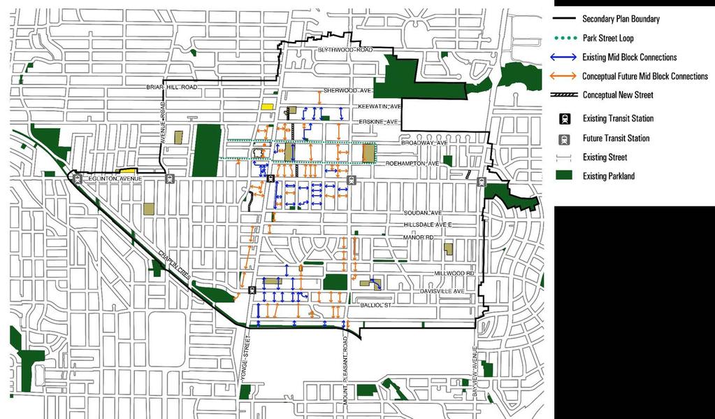
6 Midtown in Focus: Study Scope


7 Midtown in Focus: Vision & Objectives

8 Midtown in Focus: Growth Estimates
9 What is the Transportation Assessment? Supports the vision, goals, and policies of the Yonge-Eglinton Secondary Plan and is closely aligned with the Parks & Public Realm Plan Primarily about identifying local transportation needs within the Yonge-Eglinton Area to improve mobility in and through the area (e.g. it is not about solving crowding on the Yonge subway line) Will Identify a range of transportation infrastructure improvements to safely move people in and around the area and support a shift to active and sustainable travel modes in context of the anticipated growth and completion of the Eglinton Crosstown LRT Will assist in aligning transportation infrastructure capital planning with long-term growth, and inform the review of development applications in the area
 Eglinton Crosstown LRT & Eglinton Connects")
 Integrated land")

10 Midtown Transportation Assessment: Local Area Planning Official Plan (policies + maps) City-Wide Rapid Transit Network Planning (Relief Line, Smart Track, GO RER, etc) Eglinton Crosstown LRT & Eglinton Connects Planned Operational Improvements (Line 1 Automatic Train Control) Vision Zero Road Safety Plan 10 Year Cycling Network Plan Complete Streets Guidelines And others Secondary Plan (policies + maps) Integrated land use planning framework and local transportation improvements Improving local transportation networks and connections with surrounding city networks Improving range of mobility choices Targeted walking and cycling improvements And more
11 City-Wide Rapid Transit Network Planning
12 Eglinton Connects

13 Eglinton Connects
14 Midtown Transportation Assessment

15 Transportation Assessment: Phases of Work
16 Phase 1 Summary: Background Review & Analysis Existing planning policies & guidelines: Provincial Growth Plan, Metrolinx Regional Transportation Plan, City of Toronto Official Plan, City-wide rapid transit planning, Eglinton Connects, Mobility Hub Guidelines, Complete Streets Guidelines, etc. Travel trends and characteristics: Analysis of TTS data, Census data, travel time analysis, trip distribution, mode share, etc 2017 Midtown Travel Survey: An online survey of area residents and workers to assist in developing a more current snapshot of movement trends and characteristics in Midtown Safety data: Historical collision data for the area Traffic data: Intersection traffic volumes and intersection capacity analysis, origin-destination trends for through traffic, etc Pedestrian and cycling data: Intersection pedestrian and cycling volumes, inventory of sidewalk widths, area walkshed analysis and mapping, inventory of existing cycling infrastructure, review of planned 10- Year Cycling Network Plan, etc Transit ridership data: TTC subway ridership and capacity data
17 Key Issues + Challenges


18 Key Issues + Challenges 1. Future population and employment growth will continue to increase demand for travel into, out of and within Midtown, putting more pressure on existing transportation and transit infrastructure New development in Midtown should help create a compact, transitsupportive community with a mix of land uses that support more sustainable transportation choices to help reduce auto dependency

19 Key Issues + Challenges 2. Midtown is a built up urban environment with limited street space Redesign key streets to move more people more efficiently and achieve mobility and placemaking objectives

20 Key Issues + Challenges 3. Significant auto traffic congestion occurs during rush hours, but is mostly through traffic generated from outside the local Midtown area Continue to reduce auto traffic generated within Midtown and better manage auto traffic congestion and curbside activity

21 Key Issues + Challenges 4. Many people in Midtown are choosing to drive for short, local trips Improve local walking and cycling infrastructure to encourage more people to walk and cycle for short trips

22 Key Issues + Challenges 5. Future growth will result in more people walking and cycling, but key streets and intersections are currently designed mainly for cars Pedestrian and cycling improvements are needed on several key streets and at major intersections to provide more space and improve safety

23 Key Issues + Challenges 6. The area generally has a fine grain street network for pedestrian and cycling connectivity, but there are some larger blocks More mid-block and street connections are needed to improve permeability within and through the area

24 Key Issues + Challenges 7. Increasingly more people will live or work within close distance to a rapid transit station Walking and cycling improvements are needed to improve access to and from neighbourhoods outside the immediate station areas. Additional mobility choices should be provided as part of stations and new developments: car-sharing, bike sharing, etc
25 Key Issues + Challenges 8. There are significant crowding issues during the rush hours on the Yonge subway line Operational improvements and city-wide rapid transit network planning initiatives are underway to address crowding and capacity issues

26 Key Issues + Challenges 9. There are gaps in the cycling network within Midtown and a lack of connections with the surrounding city-wide cycling network Build on the 10-year Cycling Network Plan to identify new or upgraded cycling routes and make a more complete cycling network in the area

27 Key Issues + Challenges 10. Transportation technology is rapidly evolving and people s travel behaviour will also change over time with flexible work hours and locations New technology like automated or electric vehicles, is appealing, but it isn t a silver bullet that will solve the city s transportation challenges. In some cases, it could cause more traffic congestion. It s important to plan for emerging technologies, but ensure that the vision and goals for Midtown are maintained
28 Midtown Secondary Plan: Proposed Policies & Maps
29 Proposed Policy Directions Move people and goods more efficiently Provide a mix of compact land uses to reduce the need to travel longer distances Prioritize transit and active transportation infrastructure to reduce auto-dependency Design streets as more complete to improve walking and cycling networks, connections to transit, and safety for the most vulnerable Provide more pedestrian amenities (benches, etc) and endof-trip cycling facilities (eg, benches, bike parking, trees, etc) Expand Toronto Bike Share program into Midtown Secure mid-block connections within large development sites A proposed Pedestrian Network Map and Cycling Network Map

30 Cycling Network Map

31 Pedestrian Network Map
32 Focus Areas
33 What are Focus Areas? Recognizes and builds on City transportation initiatives underway or recently completed Addresses key transportation issues and challenges facing Midtown Proposes a range of recommended transportation infrastructure opportunities Informs development of future Implementation Strategy Four types of Focus Areas: Midtown-Wide Key Streets or Corridors Areas of Growth Stable Neighbourhoods

34 Focus Areas 1. Midtown-Wide 2. Key Streets or Corridors A. Yonge Street B. Eglinton Avenue C. Redpath Avenue D. Mount Pleasant Road E. Davisville Avenue/ Chaplin Cres. F. Bayview Avenue G. Duplex Avenue 3. Areas of Growth A. Roehampton Common B. Soudan West Common C. Areas around rapid transit stations 4. Stable Neighbourhoods


35 Focus Areas: Midtown-Wide Potential Solutions Implement Toronto s Vision Zero Road Safety Plan Implement10-Year Cycling Network Plan and any New Cycling Connections Identified through Midtown In Focus Expand Toronto Bike Share into Midtown Secure Electric Vehicle Charging Infrastructure and Transportation Demand Management (TDM) Measures in New Developments Review Parking Standards for Developments Around Transit Stations Implement Curbside Management Strategies
36 Focus Areas: Streets
37 Focus Areas: Streets Planned/Approved Improvements Park Street Loop and Midtown Greenways in 2014 Midtown Public Realm Plan Eglinton Crosstown LRT & stations under construction Eglinton to be reconstructed as a complete street w/ wide sidewalks, cycling facilities, trees starting between Avenue Road to Mount Pleasant Road Eglinton Green Line in 2014 Parks, Open Space and Streetscape Master Plan
38 Focus Areas: Streets Potential Solutions Make operational and pedestrian improvements at intersections Optimize on-street parking restrictions to improve on-street efficiency Restrict left turns along key pedestrian corridors Reduce speed limits on streets to 30km/hr Implement streetscape improvements (curb to building face) Reduce on-street parking and reclaim space for pedestrian amenity Revisit pedestrian scramble intersection at Yonge and Eglinton and introduce at other busy intersections Provide continuous sidewalks uninterrupted across minor, unsignalized intersections Provide dedicated cycling lanes on key streets by reducing lane widths and/or vehicular lanes Redesign and reconstruct streets as complete streets


39 Potential Solutions Focus Areas: Streets
40 Focus Areas: Areas of Growth Planned/Approved Improvements Park Street Loop and Midtown Greenways in 2014 Midtown Public Realm Plan

41 Focus Areas: Areas of Growth Potential Solutions Secure mid-block connections as part of new development Secure shared public parking in first level underground garages of new development Change on-street parking restrictions Implement bike share stations at key locations Improve entrances to existing rapid transit stations Implement the Park Street Loop and Midtown Greenways as part of development Redesign Cowbell Lane as a shared street to improve pedestrian and cyclist safety Widen sidewalks on local streets to accommodate increased pedestrian traffic Narrow vehicular lanes on Broadway, Roehampton and Soudan
42 Focus Areas: Stable Neighbourhoods Potential Solutions Widen sidewalks to improve accessibility and as maintenance occurs on streets Provide dedicated space for cycling lanes on key local streets to provide enhanced access to destinations Implement innovative traffic calming measures


43 Potential Solutions Focus Areas: Stable Neighbourhoods
44 Next Steps + Workshop
45 Next Steps Identify, map, and catalogue the focus areas, taking into account the City's growth estimates Finalize transportation policies and maps in the Secondary Plan Inform future Implementation Strategy Report to City Council
46 Workshop Activity 1: Focus Areas (10 Minutes) Are there focus areas you think we ve missed? What are they and how do you think they will improve movement? Identify problem areas with a red dot and write down key issues on a sticky note. Activity 2: Streets Dotmocracy (15 Minutes) Identify the measure or measures you think should be implemented and prioritized for streets in Midtown with a GREEN dot. Use a YELLOW dot to identify solutions you think are not absolutely necessary, but would be nice to have Activity 3: Pedestrian and Cycling Network (15 Minutes) What do you think of the proposed Pedestrian and Cycling Network? Have we missed any important connections?
WELCOME TO OPEN HOUSE # 1 June 14, 2017
 Langstaff Road Weston Road to Highway 7 Class Environmental Assessment Study WELCOME TO OPEN HOUSE # 1 June 14, 2017 Please sign in and join our mailing list Purpose of Open House #1 & Study Area York
Transportation Master Plan Advisory Task Force
 Transportation Master Plan Advisory Task Force Network Alternatives & Phasing Strategy February 2016 BACKGROUND Table of Contents BACKGROUND Purpose & Introduction 2 Linking the TMP to Key Council Approved
APPENDIX 2 LAKESHORE ROAD TRANSPORTATION REVIEW STUDY EXECUTIVE SUMMARY
 APPENDIX 2 LAKESHORE ROAD TRANSPORTATION REVIEW STUDY EXECUTIVE SUMMARY Appendix 2 City of Mississauga Lakeshore Road FINAL REPORT Transportation Review Study December 2010 EXECUTIVE SUMMARY Study Purpose
In station areas, new pedestrian links can increase network connectivity and provide direct access to stations.
 The Last Mile Planning for Pedestrians Planning around stations will put pedestrians first. Making walking to stations safe and easy is important; walking will be a part of every rapid transit Accessible
Road Alterations - Wellington Street East, Church Street, and Front Street Intersection
 REPORT FOR ACTION Road Alterations - Wellington Street, Church Street, and Front Street Intersection Date: November 1, 2016 To: Toronto and York Community Council From: Director, Public Realm Section,
Public Event 1 Community Workshops
 Public Event 1 Community Workshops Nov. 24 & Dec. 3, 2016 Welcome Workshop Purpose We re looking to you for ideas and insights to help guide future transportation infrastructure planning in the Park Lawn
Moving Cambridge. City of Cambridge Transportation Master Plan Public Consultation Centre. March 7, :00 8:00 PM.
 City of Cambridge Transportation Master Plan Public Consultation Centre March 7, 2018 5:00 8:00 PM Region of Waterloo City of Cambridge Transportation Master Plan Public Consultation Centre March 7, 2018
York Region Population and Employment Growth
 March 1, 2016 1 York Region Population and Employment Growth York Region needs to comply with The Provincial Growth Plan and new forecasts introduced to 2036 and 2041 2 Regional Official Plan Review York
7 Yonge and Steeles Area Regional Transportation Study City of Markham and City of Vaughan
 Clause 7 in Report No. 17 of Committee of the Whole was adopted, without amendment, by the Council of The Regional Municipality of York at its meeting held on November 19, 2015. 7 Yonge and Steeles Area
PG29.6 REPORT FOR ACTION. Downtown Mobility Strategy SUMMARY
 PG29.6 REPORT FOR ACTION Downtown Mobility Strategy Date: April 17, 2018 To: Planning and Growth Management Committee From: Chief Planner and Executive Director, City Planning and General Manager, Transportation
Proposed. City of Grand Junction Complete Streets Policy. Exhibit 10
 Proposed City of Grand Junction Complete Streets Policy Exhibit 10 1 City of Grand Junction Complete Streets Policy Vision: The Complete Streets Vision is to develop a safe, efficient, and reliable travel
Hennepin County Bicycle and Pedestrian Planning
 Hennepin County Bicycle and Pedestrian Planning 1 Value of bicycle and sidewalk systems Safety Livability Mobility Health Personal Finances Economic Sustainability Clean Air Recreation Parking and congestion
City of Waterloo Complete Streets Policy
 City of Waterloo Complete Streets Policy Chris Hodgson P. Eng City of Waterloo Complete Streets Forum 2011 April 28-29 Toronto Waterloo context: Current population Major employers Universities and student
PEDESTRIAN ACTION PLAN
 ATTACHMENT 2 CITY OF SANTA MONICA PEDESTRIAN ACTION PLAN CITY OF SANTA MONICA PEDESTRIAN ACTION PLAN This page intentionally left blank EXECUTIVE SUMMARY CHAPTER 1 EXECUTIVE SUMMARY Setting the Stage
122 Avenue: 107 Street to Fort Road
 : 107 Street to Fort Road November 24, 2015 4:30 8:00 p.m. Meeting Purpose Summarize project work completed to date Share results of public input from Phase 1 Share the draft concept plan and proposed
Ann Arbor Downtown Street Plan
 1 Ann Arbor Downtown Street Plan Public Workshop #1 We know that. 2 Public right-of-way (streets, sidewalks, and alleys) make up 30% of the total District area of downtown. Streets need to provide mobility
WELCOME! To the Centennial Neighbourhoods Secondary Plan and Transportation Management Plan Information Centre. City of Hamilton
 WELCOME! To the Centennial Neighbourhoods Secondary Plan and Transportation Management Plan Information Centre City of Hamilton Public Information Centre #2 Dec 1, 2015 CENTENNIAL NEIGHBOURHOODS SECONDARY
CITY OF VAUGHAN EXTRACT FROM COUNCIL MEETING MINUTES OF OCTOBER 30, 2012
 CITY OF VAUGHAN EXTRACT FROM COUNCIL MEETING MINUTES OF OCTOBER 30, 2012 Item 31, Report No. 39, of the Committee of the Whole, which was adopted without amendment by the Council of the City of Vaughan
Bicycle Master Plan Goals, Strategies, and Policies
 Bicycle Master Plan Goals, Strategies, and Policies Mobilizing 5 This chapter outlines the overarching goals, action statements, and action items Long Beach will take in order to achieve its vision of
Major Bike Routes 102 Avenue Workshop April 21, 2015
 Major Bike Routes 102 Avenue Workshop April 21, 2015 Our Purpose Today Provide context on how Major Bike Routes fit into Edmonton s future Share information on what we heard in our last phase, and how
Centennial Neighbourhoods Transportation Management Plan Summary of Phase 1 Consultation. Overview of Issues
 1 Centennial Neighbourhoods Transportation Management Plan Summary of Phase 1 Consultation The Centennial Neighbourhoods Transportation Management Plan (CNTMP) is being undertaken to support the Secondary
Appendix 1 Transit Network Analysis
 Appendix 1 Transit Network Analysis APPENDIX 1 TRANSIT NETWORK ANALYSIS The purpose of this appendix is to provide an update on the transit network analysis as it pertains to: i. SmartTrack ii. Scarborough
DUNDAS WEST-BLOOR Mobility Hub Profile
 Mobility Hub Profile Dundas West-Bloor Anchor Hub Gateway Hub N MOBILITY HUBS: Places of connectivity between regional and rapid transit services, where different modes of transportation come together
Tonight is for you. Learn everything you can. Share all your ideas.
 Strathcona Neighbourhood Renewal Draft Concept Design Tonight is for you. Learn everything you can. Share all your ideas. What is Neighbourhood Renewal? Creating a design with you for your neighbourhood.
DON MILLS-EGLINTON Mobility Hub Profile
 Mobility Hub Profile Dundas Don Mills-Eglinton West-Bloor Anchor Hub Gateway Hub N MOBILITY HUBS: Places of connectivity between regional and rapid transit services, where different modes of transportation
University of Victoria Campus Cycling Plan Terms of Reference. 1.0 Project Description
 University of Victoria Campus Cycling Plan Terms of Reference 1.0 Project Description The Campus Cycling Plan, a first for the University, will provide a comprehensive and coordinated approach to support
10.0 CURB EXTENSIONS GUIDELINE
 10.0 CURB EXTENSIONS GUIDELINE Road Engineering Design Guidelines Version 1.0 March 2017 City of Toronto, Transportation Services City of Toronto Page 0 Background In early 2014, Transportation Services
Bikeway action plan. Bicycle Friendly Community Workshop March 5, 2007 Rochester, MN
 Bikeway action plan Summary The was held on March 5, 2007 at the Rochester Mayo Civic Center. The workshop was hosted by Rochester-Olmsted County Planning Department in collaboration with the League of
Welcome. Background. Goals. Vision
 Welcome The formal Public Information Centre (PIC) for the Transportation Master Plan How We GO will be held in early 2017. At that time we will present the recommended transportation system for Niagara
City of Hamilton s Transportation Master Plan (TMP) Public Consultation 3 December 2015
 Public Consultation 3 December 2015") City of Hamilton s Transportation Master Plan (TMP) Public Consultation 3 December 2015 McPhail Transportation Planning Services Ltd. AGENDA 6:00 7:00 pm Viewing Boards / Q & A with the Team 7:00 7:50
City of Hamilton s Transportation Master Plan (TMP) Public Consultation 3 December 2015 McPhail Transportation Planning Services Ltd. AGENDA 6:00 7:00 pm Viewing Boards / Q & A with the Team 7:00 7:50
PEDESTRIAN ACTION PLAN
 CITY OF SANTA MONICA PEDESTRIAN ACTION PLAN DRAFT OCTOBER 2015 Safe Streets Santa Monica, December 3, 2015 Beth Rolandson, AICP Principal Transportation Planner Strategic + Transportation Planning, Planning
CITY OF BLOOMINGTON COMPLETE STREETS POLICY
 CITY OF BLOOMINGTON COMPLETE STREETS POLICY POLICY OBJECTIVE: The City of Bloomington will enhance safety, mobility, accessibility and convenience for transportation network users of all ages and abilities,
2.0 LANE WIDTHS GUIDELINE
 2.0 LANE WIDTHS GUIDELINE Road Engineering Design Guidelines Version 2.0.1 May 2018 City of Toronto, Transportation Services City of Toronto Page 0 Background In early 2014, Transportation Services initiated
Markham Sports, Entertainment and Cultural Centre Transportation Overview
 Markham Sports, Entertainment and Cultural Centre Transportation Overview ARENA LOCATION 2 3 TRANSPORTATION VISION IN MARKHAM On April 12, 2011, Markham Council adopted a long-term Transportation Vision
Chapter 5 Future Transportation
 Chapter 5 Future Transportation The Future Land Use Plan identifies the desired land use designations. The land uses desired for Crozet depend, in large part, on the success of the transportation system,
NEWMARKET CENTRE Mobility Hub Profile
 Mobility Hub Profile Dundas Newmarket West-Bloor Centre Anchor Hub Gateway Hub N MOBILITY HUBS: Places of connectivity between regional and rapid transit services, where different modes of transportation
FOLSOM-HOWARD STREETSCAPE OVERVIEW
 FOLSOM-HOWARD STREETSCAPE OVERVIEW SoMa residents should have the same kinds of amenities that other neighborhoods have. The Folsom- Howard Streetscape Project will make SoMa more livable by making it
Workshop Feedback Report
 Page 1 of 7 Workshop Feedback Report Stakeholder Workshop #1 Wednesday, August 19, 2015 Workshop Feedback Report This report outlines the key messages and input from the Stakeholder Workshop held on August
Environment and Public Works Committee Presentation
 Mixed Use Centers Complete Streets Guidelines Project Environment and Public Works Committee Presentation December 10, 2008 Project Objectives: Conduct an inter-departmental and agency process to study
NORTH YORK CENTRE Mobility Hub Profile
 Mobility Hub Profile Dundas North York West-Bloor Centre Anchor Hub Gateway Hub N MOBILITY HUBS: Places of connectivity between regional and rapid transit services, where different modes of transportation
Complete Streets. Designing Streets for Everyone. Sarnia
 Complete Streets Designing Streets for Everyone Sarnia Complete Streets ~ Sarnia ~ 2018 Introduction Our City is made up of a network of streets that we use to go for a walk, cycle to work, drive to the
Welcome! Public Open House on UBC s Transportation Plan
 1 Welcome! Public Open House on UBC s Transportation Plan Public open house hours: to When it comes to on-campus transportation, what do you think is working well and what are some opportunities for improvement?
Leaside Traffic Calming Plan Update. Community Meeting 2 November 22, :00 PM
 Leaside Traffic Calming Plan Update Community Meeting 2 November 22, 2016 7:00 PM Welcome and Study Background Welcome and Thank You! Study background from LPOA s perspective: Why are we doing this study?
Goal 3: Foster an environment of partnerships and collaboration to connect our communities and regions to one another.
 Non-Motorized Transportation Plan (NMTP) Draft Vision, Goal and,, Tri-County Regional Planning Commission (TCRPC) Purpose The purpose of the Tri-County Regional Planning Commission (TCRPC) Non-Motorized
Chapter 7. Transportation. Transportation Road Network Plan Transit Cyclists Pedestrians Multi-Use and Equestrian Trails
 Chapter 7 Transportation Transportation Road Network Plan Transit Cyclists Pedestrians Multi-Use and Equestrian Trails 7.1 TRANSPORTATION BACKGROUND The District of Maple Ridge faces a number of unique
Public Works and Infrastructure Committee. General Manager, Transportation Services
 STAFF REPORT ACTION REQUIRED Extending the Bay Street Bicycle Lanes Date: May 16, 2013 To: From: Public Works and Infrastructure Committee General Manager, Transportation Services Wards: Toronto Centre
West Village Mobility & Integration
 West Village Mobility & Integration PRESENTED TO TOPCA Town Hall November 9, 2017 [7189-21] Port Credit 2 West Village + Mobility AWalkable Community A CompleteCommunity A SustainableCommunity 3 Mobility
City of Novi Non-Motorized Master Plan 2011 Executive Summary
 City of Novi Non-Motorized Master Plan 2011 Executive Summary Prepared by: February 28, 2011 Why Plan? Encouraging healthy, active lifestyles through pathway and sidewalk connectivity has been a focus
Transportation Master Plan April 2017 i
 Transportation Master Plan April 2017 i City of Regina Policy Title Transportation Master Plan (TMP) Version Version 2.1, April 2017 Policy 2017-1-CPD Tracking # Link to the This master plan provides further
DON MILLS-SHEPPARD Mobility Hub Profile
 DON MILLS-SHEPPARD Mobility Hub Profile Dundas Don Mills-Sheppard West-Bloor Anchor Hub Gateway Hub N MOBILITY HUBS: Places of connectivity between regional and rapid transit services, where different
STONY PLAIN ROAD STREETSCAPE
 Jasper Place Revitalization Strategy: Vision The people involved in the Jasper Place Revitalization Strategy envision: Goal 1: Feeling safe in our community Create a community where feeling safe is common--where
4 DISRUPTION MANAGEMENT PLAN HIGHWAY 7 RAPIDWAY CONSTRUCTION BETWEEN BAYVIEW AVENUE AND WARDEN AVENUE TOWNS OF MARKHAM AND RICHMOND HILL
 4 DISRUPTION MANAGEMENT PLAN HIGHWAY 7 RAPIDWAY CONSTRUCTION BETWEEN BAYVIEW AVENUE AND WARDEN AVENUE TOWNS OF MARKHAM AND RICHMOND HILL The Transportation Services Committee recommends the adoption of
Pocatello Regional Transit Master Transit Plan Draft Recommendations
 Pocatello Regional Transit Master Transit Plan Draft Recommendations Presentation Outline 1. 2. 3. 4. What is the Master Transit Plan? An overview of the study Where Are We Today? Key take-aways from existing
Welcome. If you have any questions or comments on the project, please contact:
 Welcome This drop-in public open house is intended to provide information about the Bay Street bike lanes project. This project proposes a dedicated cycling facility along Bay Street between Aberdeen Avenue
Building sidewalks on local streets to reduce accessibility barriers
 Building sidewalks on local streets to reduce accessibility barriers Disability, Access, Inclusion and Advisory Committee 16 February 2016 Fiona Chapman, Manager, Pedestrian Projects Presentation overview
Complete Streets Policy Framework
 Complete Streets Policy Framework City of Vancouver Complete Streets Planning 2017 Complete Streets Recommendations: Council receive for information the Citywide Complete Streets policy framework Council
San Jose Transportation Policy
 San Jose Transportation Policy Protected Intersections in LOS Policies to Support Smart Growth Presented by: Manuel Pineda City of San Jose Department of Transportation Bay Area Map San Francisco Oakland
Submission to Metrolinx on Eglinton LRT - East End. Response to December 2012 Public Meeting
 Submission to Metrolinx on Eglinton LRT - East End Project Response to December 2012 Public Meeting Prepared by: Cycle Toronto, cycleto.ca Authors: John Taranu, Michael Black January 21, 2013 1 Introduction
WEST AND SOUTH WEST RING ROAD DOWNSTREAM TRAFFIC IMPACTS
 Page 1 of 9 EXECUTIVE SUMMARY Alberta Transportation ( AT ) is preparing to construct the final sections of the Calgary Ring Road. This includes the South West Ring Road ( SWRR ) (from Lott Creek Blvd
APPENDIX B. TDM Existing Conditions
 APPENDIX B TDM Existing Conditions SCARBOROUGH CENTRE TMP TRANSPORTATION DEMAND MANAGEMENT INTRODUCTION Scarborough Centre has grown into a mixed-use hub for population, transportation, and employment
Frequently Asked Questions (FAQ)
") Frequently Asked s (FAQ) Study Process... 2 Rapid Transit Service and Operations... 5 Public Consultation... 8 Business Impacts... 8 Design and Property Impacts... 9 Construction Impacts...12 Traffic,
Frequently Asked s (FAQ) Study Process... 2 Rapid Transit Service and Operations... 5 Public Consultation... 8 Business Impacts... 8 Design and Property Impacts... 9 Construction Impacts...12 Traffic,
TRANSPORTATION NEEDS ASSESSMENT
 TRANSPORTATION NEEDS ASSESSMENT A travel demand analysis was carried out to determine the operational issues and the potential benefit that adding traffic capacity would have on the road network. All the
Byron Avenue. Public Meeting. Thursday June 16, Traffic Calming Design Sherbourne Road to Island Park Drive
 Byron Avenue Traffic Calming Design Sherbourne Road to Island Park Drive Public Meeting Thursday June 16, 2016 Our Lady of Fatima Parish 153 Woodroffe Avenue 6 9pm 1 Project Summary Area Projects Background
Kitchener Integrated Transportation Master Plan
 Final Report Kitchener Integrated Transportation Master Plan TRANSPORTATION S ROLE IN A COMPLETE AND HEALTHY KITCHENER June 2013 Table of Contents Executive Summary: Implementation Measures... 1 1. Travel
Public Works and Infrastructure Committee. General Manager, Transportation Services. P:\2016\Cluster B\TRA\TIM\pw16009tim.docx
 Ten Year Cycling Network Plan Date: May 3, 2016 STAFF REPORT ACTION REQUIRED PW13.11 To: From: Wards: Reference Number: Public Works and Infrastructure Committee General Manager, Transportation Services
Appendix B Workshop Materials
 Appendix B Workshop Materials Public Event 1 Community Workshops Nov. 24 & Dec. 3, 2016 Welcome Workshop Purpose We re looking to you for ideas and insights to help guide future transportation infrastructure
Appendix A-K Public Information Centre 2 Materials
 Appendix A-K Public Information Centre 2 Materials Our Rapid Transit Initiative Make an impact on the future of transit Join the discussion on Rapid Transit in London You re invited to a Public Information
Chapter 2. Bellingham Bicycle Master Plan Chapter 2: Policies and Actions
 Chapter 2 Bellingham Bicycle Master Plan Chapter 2: Policies and Actions Chapter 2: Policies and Actions The Bicycle Master Plan provides a road map for making bicycling in Bellingham a viable transportation
TRANSPORTATION STUDY REPORT DRAFT - APRIL 2015 A BLUEPRINT FOR HOW WE CAN GET AROUND GREATER SUDBURY, FROM NOW UNTIL 2031
 TRANSPORTATION STUDY REPORT DRAFT - APRIL 2015 A BLUEPRINT FOR HOW WE CAN GET AROUND GREATER SUDBURY, FROM NOW UNTIL 2031 A summary of what s there, what more is needed, how to find information about your
Terwillegar Drive Expressway Draft Concept Plan
 Terwillegar Drive Expressway Draft Concept Plan Anthony Henday Drive to Whitemud Drive November 28 5:00-8:00 p.m. December 1 10:00 a.m. - 3:00 p.m. Let s Talk Today you can: Learn about the new direction
Better Market Street Project. Project Update January 15, 2015
 Better Market Street Project Project Update January 15, 2015 Better Market Street Project Area Limits Market Street 2.2 Miles Mission Street Better Market Street Schedule Market Street City s busiest transit
Active Transportation Infrastructure Investment A Business Case
 Active Transportation Infrastructure Investment A Business Case In 2016, the Real Estate Foundation awarded the Capital Regional District a $50,000 grant for Shifting Gears: Land Use Change through Active
Governance and Priorities Committee Report For the July 2, 2015 Meeting
 CITY OF VICTORIA For the July 2, 2015 Meeting To: Governance and Priorities Committee Date: From: Subject: Brad Dellebuur, A/Assistant Director, Transportation and Parking Services Executive Summary The
City of Charlottesville Bicycle and Pedestrian Master Plan Update
 City of Charlottesville Bicycle and Pedestrian Master Plan Update September 17, 2014 I. Welcome and meeting overview II. Project status update III. Network overview IV. Break-out groups Pedestrian Network
PEDALING FORWARD. A Glance at the SFMTA s Bike Program for SFMTA.COM
 PEDALING FORWARD A Glance at the SFMTA s Bike Program for 2017-2021 SFMTA.COM INTRODUCTION About This Booklet More people from all walks of life see their bicycle as a more convenient way to get where
CITY OF COCOA BEACH 2025 COMPREHENSIVE PLAN. Section VIII Mobility Element Goals, Objectives, and Policies
 CITY OF COCOA BEACH 2025 COMPREHENSIVE PLAN Section VIII Mobility Element Goals, Objectives, and Policies Adopted August 6, 2015 by Ordinance No. 1591 VIII MOBILITY ELEMENT Table of Contents Page Number
First Mile, Last Mile: Plans for all Shapes and Sizes. Hannah Lindelof, Principal Planner San Francisco Bay Area Rapid Transit September 18, 2017
 First Mile, Last Mile: Plans for all Shapes and Sizes Hannah Lindelof, Principal Planner San Francisco Bay Area Rapid Transit September 18, 2017 BART Station Access Policy Goals A. Safer, Healthier, Greener.
Highway 56 Traffic Study Rymal Road to Cemetery Road
 January 31, 2018 6:00 pm 8:00 pm Highway 56 Traffic Study Rymal Road to Cemetery Road City of Hamilton Public Meeting 2 2 Purpose of Public Meeting To review and obtain public input and comments on the
CITY OF HAMILTON PLANNING AND ECONOMIC DEVELOPMENT DEPARTMENT Transportation Planning and Parking Division
 CITY OF HAMILTON PLANNING AND ECONOMIC DEVELOPMENT DEPARTMENT Transportation Planning and Parking Division TO: Chair and Members Public Works Committee COMMITTEE DATE: June 18, 2018 SUBJECT/REPORT NO:
Downtown BRT Corridor Alternatives Review: 1 st, 2 nd, 3 rd and 4 th Avenue. Bus Rapid and Conventional Transit Planning and Design Services
 Downtown BRT Corridor Alternatives Review: 1 st, 2 nd, 3 rd and 4 th Avenue Bus Rapid and Conventional Transit Planning and Design Services City of Saskatoon February 2018 Project Team HDR Corporation
ACTIVE TRANSPORTATION
 ACTIVE TRANSPORTATION Mobility 2040 Supported Goals Improve the availability of transportation options for people and goods. Support travel efficiency measures and system enhancements targeted at congestion
Toronto and East York Community Council. Director, Transportation Services, Toronto and East York District
 No Turn on Red Regulations STAFF REPORT ACTION REQUIRED Date: June 1, 2010 To: From: Toronto and East York Community Council Director, Transportation Services, Toronto and East York District Wards: Trinity
CHAPTER 3: Vision Statement and Goals
 Davidson Walks & Rolls: Active Transportation Master Plan CHAPTER 3 Contents: Overview Vision Statement Measurable Goals Public Outreach CHAPTER 3: Vision Statement and Goals Overview The vision statement
Community Task Force July 25, 2017
 Community Task Force July 25, 2017 Welcome and Introductions Project Partners Regional Transportation District (RTD) Colorado Department of Transportation (CDOT) Denver Regional Council of Governments
SCARBOROUGH CENTRE TRANSPORTATION MASTER PLAN (SCTMP)
") SCARBOROUGH CENTRE TRANSPORTATION MASTER PLAN (SCTMP) Public Consultation Meeting #2 May 10 th, 2017 Presentation Outline 1 Project Schedule and Background 2 Draft Evaluation of Alternatives 3 Preliminary
SCARBOROUGH CENTRE TRANSPORTATION MASTER PLAN (SCTMP) Public Consultation Meeting #2 May 10 th, 2017 Presentation Outline 1 Project Schedule and Background 2 Draft Evaluation of Alternatives 3 Preliminary
Welcome. The Brooklin Secondary Plan and Transportation Master Plan are collectively referred to as the Brooklin Study.
 Welcome The Town of Whitby is undertaking a study to prepare a Secondary Plan and Transportation Master Plan to guide and manage growth in the Brooklin area. The Brooklin Secondary Plan and Transportation
4 Ridership Growth Study
 Clause 4 in Report No. 15 of Committee of the Whole was adopted, without amendment, by the Council of The Regional Municipality of York at its meeting held on November 16, 2017. 4 Ridership Growth Study
Tunnel Reconstruction South 5 th Street Association October 16, 2018
 Tunnel Reconstruction South 5 th Street Association October 16, 2018 Reconstructing the Tunnel 2 Service During Tunnel Reconstruction April 2019 through July 2020 3 Projected Cross River Travel Paths of
Access BART: TOD and Improved Connections. October 29, 2008
 Access BART: TOD and Improved Connections October 29, 2008 1 Access BART Study Goals Evaluate at the system-level land use and access scenarios to optimize ridership Identify station clusters that provide
Ajax: The Road to Complete Streets
 Ajax: The Road to Complete Streets Hubert Ng, Senior Transportation Planner Elysia Leung, Transportation Demand Management Coordinator Complete Streets Forum October 1, 2015 Overview 1 2 Introduction to
Pedestrian Crosswalk Audit
 1200, Scotia Place, Tower 1 10060 Jasper Avenue Edmonton, Alberta T5J 3R8 edmonton.ca/auditor Pedestrian Crosswalk Audit June 19, 2017 The conducted this project in accordance with the International Standards
PROPOSED BYLAW UPDATES AND FEES FOR SIDEWALK CAFÉS & MARKETING DISPLAYS
 Transportation Services Municipal Licensing and Standards PROPOSED BYLAW UPDATES AND FEES FOR SIDEWALK CAFÉS & MARKETING DISPLAYS PUBLIC CONSULTATIONS June 13, 2017 Toronto City Hall June 20, 2017 North
A CHANGING CITY. of Edmonton, it is essential that it reflects the long-term vision of the City.
 A CHANGING CITY By the year 2040, Edmonton will be home to more than 1 million people. To accommodate growth and support a healthy and compact city, we need a new approach to development/redevelopment
Existing Pedestrian Conditions. PSAC February 8, 2011
 Existing Pedestrian Conditions PSAC February 8, 2011 Contents 1. Project Background & Goals 2. Pedestrian Activity: Where people walk 3. Pedestrian Safety: The conditions people face Project Background
CPC Parking Lot Riverside Drive. Transportation Rationale
 CPC Parking Lot Transportation Rationale Prepared By: NOVATECH Suite 200, 240 Michael Cowpland Drive Ottawa, Ontario K2M 1P6 September 2015 Novatech File: 114093 Ref: R-2015-153 Table of Contents 1.0 INTRODUCTION...
CONNECTING PEOPLE TO PLACES
 CONNECTING PEOPLE TO PLACES 82 EAST BENCH MASTER PLAN 07 Introduction The East Bench transportation system is a collection of slow moving, treelined residential streets and major arteries that are the
Outreach Approach RENEW SF served as the primary liaison with the North Beach community; the Chinatown. Executive Summary
 Executive Summary Executive Summary The Columbus Avenue Neighborhood Transportation Study s objective is to identify changes to transportation infrastructure and policies that could enhance the livability
Public Information Centre
 WELCOME Public Information Centre Father Tobin Road Lougheed Middle School - Library Wednesday November 7, 2012 7:00 p.m.to 9:00 p.m. Please sign in Neighbourhood Traffic Calming Guide Background The City
Corridor Vision Workshop Summary James Madison Elementary February 22,2018
 Corridor Vision Workshop Summary James Madison Elementary February 22,2018 WHY DEVELOP THIS STUDY? Ogden City is planning for better connectivity and access to jobs and housing. Working with area partners,
Complete Streets Successes, Opportunities, and Challenges
 Complete Streets Successes, Opportunities, and Challenges Juliet Walker, Transportation Planner, City of Portsmouth Rob Houseman, Director of Planning and Development, Town of Wolfeboro Chris Parker, Director