Chapter 4 Engineering 4.12 Sample Cross-Sections
|
|
|
- Brenda Richardson
- 6 years ago
- Views:
Transcription
1 The following text was originally published as part of MORPC s Complete Streets checklist, along with our adopted policy. It is included here both for completeness and for visual updates. Three dimensional images of the sample cross-sections are now included. The images are available if people are interested in using them. They were created with the free software Google SketchUp. Photos, renderings, cross-sections, and 3D images can help residents and stakeholders visualize various alternatives for a corridor. The following are sample Complete Streets cross-sections for rural, suburban, and urban roads. These are only examples and are not meant to be the only allowable Complete Streets you can build. These examples are offered to get you thinking and are not meant as prescriptions. More information will be provided in MORPC s Complete Streets toolkit, including crosswalks, turn lanes, transit shelters, and roundabouts. Design guidelines should always be followed during detailed engineering design of your roadway cross-section. Also note that education, enforcement, and encouragement play an important part in making these projects successful and should be included as part of any infrastructure project. Possible strategies and resources will be part of the toolkit. Every attempt was made to ensure the following example cross-sections conformed to national and state standards. For more notes on this, please see Notes on Sources for Design Standards (on page 24) for specific citations we used as we developed our examples. You may also want to reference section 4.2 for more information on standards and guidelines. Cross-section Examples in this document: 1. Rural 4-lane Road 2. Rural 2-lane Road 3. Suburban 5-lane Road (Without Parking) 4. Suburban 5-lane Road (With Parking) 5. Suburban 3-lane Road (Without Parking) 6. Urban 4-lane Road (Without Parking) 7. Urban 4-lane Road (With Parking) 8. Urban 2-lane Road (Without Parking) 9. Urban 2-lane Road (With Parking) There is a wide range of acceptable values to consider. Some of the different factors you would consider include design speed, truck traffic volumes, turning lane needs, drainage, maintenance, and type of landscaping and street tree canopy desired. The following examples are not intended to be prescriptive or to preclude other types of design. They are merely examples and actual road design will vary depending on the individual context. 1


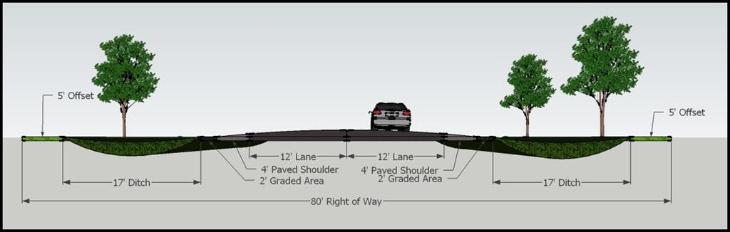
2 Example 1 for Complete Streets Rural 4-Lane Road Rural road designs should be used in areas that are expected to remain rural for the next years. Shoulder width and general road configuration are dependent on the traffic volume of each road. A multi-use path may be built for additional accommodation (see Example 2). Example 1 Rural 4-Lane Road (Source: Google Maps Street View) Recommended Minimum Accommodation Example of Rural 4-Lane Road Example 1 Rural 4-Lane Road Alternate views Examples of Rural 4 Lane Road Alternate Views 2
, minimum shoulder width is 4 feet. Minimum shoulder width is 8 feet for roads with both > 1500 ADT and 50 mph design speed.")
.")

3 Example 2 for Complete Streets Rural 2-Lane Road Example 2 Rural 2-Lane Road (Source: Google Maps Street View) Rural road designs should be used in areas that are expected to remain rural for the next years. As per the ODOT L&D Manual (Table 301-3E), minimum shoulder width is 4 feet. Minimum shoulder width is 8 feet for roads with both > 1500 ADT and 50 mph design speed. As per the ODOT L&D Manual (Table 301-2E), lane width may be reduced to 11 feet for roads with both < 2000 ADT and design speed of 45 mph. Some roads with combinations of low design speed and low ADT may have lane widths further reduced to 10 feet or below (see ODOT L&D Manual Table 301-2E). Recommended Minimum Accommodation Example of Rural 2-Lane Road Multi-Use Path Option for Rural 2-Lane Road Example The cross-section below shows a rural road with a parallel multi-use path to accommodate additional pedestrian and bicycle traffic. Pedestrians and bicyclists may still legally use the shoulder. Bicyclists may also use the travel lanes. A multi-use path (MUP) may be built parallel to the road to accommodate additional bicycle and pedestrian traffic. Bicyclists may also legally use the travel lanes. The recommended MUP width is 10 ft, plus 2 ft graded shoulders. 3

 Example")


4 Example 2 for Complete Streets Rural 2-Lane Road (Continued) Example of Rural 2-Lane Road Cross-Section View Examples of Rural 2-Lane Road Alternate Views Example 2 Rural 2-Lane Road MUP Option Alternate views 4 Examples of Rural 2-Lane Road Alternate Views
 As per the ODOT L&D Manual (Table 306-1E), sidewalks should be provided wherever there are 1 or more residences per acre.")

 In this example, lanes are narrowed to 11 feet (permitted for local, collector, and arterial streets with <")
5 Example 3 for Complete Streets Suburban 5-Lane Road (Without On-Street Parking) Example of Suburban 5-Lane Road (Without On-Street Parking) (Source: Google Maps Street View) As per the ODOT L&D Manual (Table 306-1E), sidewalks should be provided wherever there are 1 or more residences per acre. Bicyclists can use the travel lanes. Shared-lane markings (sharrows) can be used if the design speed is 35 mph or less. At speeds above 35 mph, bicycle lanes are recommended. Drainage is provided by curb and gutter. Recommended Minimum Accommodations for Suburban 5-Lane Road (Without On- Street Parking) Example for providing additional accommodation for Suburban 5-Lane Road (Without On-Street Parking) In this example, lanes are narrowed to 11 feet (permitted for local, collector, and arterial streets with < 50 mph design speed, as per ODOT L&D Manual Table 301-4E), and bicycle lanes are added. 5
")

6 Example 3 for Complete Streets Suburban 5-Lane Road (Without On-Street Parking) Examples of Suburban 5-Lane Road (Without On-Street Parking) Alternate Views 6
, sidewalks should be provided wherever there are 1 or more residences per acre. Bicyclists can use the travel lanes.")

.")
7 Example 4 for Complete Streets Suburban 5-Lane Road (With On-Street Parking) Example of Suburban 5-Lane Road (With On-Street Parking) (Source: Google Maps Street View) As per the ODOT L&D Manual (Table 306-1E), sidewalks should be provided wherever there are 1 or more residences per acre. Bicyclists can use the travel lanes. Shared lane markings (sharrows) can be used if the design speed is 35 mph or less. At speeds above 35 mph, bicycle lanes are recommended. Bicycle lanes and sharrows should not be placed in the door zone. Drainage is provided by curb and gutter. Example of Suburban 5-Lane Road (With On-Street Parking) Suburban 5-Lane Road (With On-Street Parking) Road Diet Example of Road Diet for Suburban 5-Lane Road (With On-Street Parking) In this example, the center turn lane has been removed and travel lanes have been narrowed to 11 feet (permitted for streets with lower design speed, as per ODOT L&D Manual Table 301-4E). This street design is appropriate for a suburban area with higher existing or expected volumes of pedestrian and bicycle traffic. A detailed traffic operation and capacity analysis has indicated that the center turn lane can be removed, and a parking study has shown that the existing on-street parking is still needed. Bicycle lanes should not be placed in the door zone. The door zone must be marked and signed so that motorists and bicyclists understand that it is not a travel lane. 7
 Alternate Views")
 Road Diet Option")

8 Example 4 Suburban 5-Lane Road (With On-Street Parking) Alternate Views Examples of Suburban 5-Lane Road (Without On-Street Parking) Alternate Views Example 4 Suburban 5-Lane Road (With On-Street Parking) Road Diet Option Alternate Views Examples of Road Diet Option of Suburban 5-Lane Road (Without On-Street Parking) - Alternate Views 8
, sidewalks should be provided wherever there are 1 or more residences per acre.")


9 Example 5 for Complete Streets Suburban 3-Lane Road (Without On-Street Parking) Example of Suburban 3-Lane Road (Source: Google Maps Street View) As per the ODOT L&D Manual (Table 306-1E), sidewalks should be provided wherever there are 1 or more residences per acre. Bicyclists can use the travel lanes. Shared-lane markings (sharrows) can be used if the design speed is 35 mph or less. At speeds above 35 mph, bicycle lanes are recommended. Drainage is provided by curb and gutter. Recommended Minimum Accommodations for Suburban 3-Lane Road Example for providing additional accommodation for Suburban 3-Lane Road In this example, sidewalks have been widened, bicycle lanes have been added, and travel lanes have been narrowed to 11 feet (permitted for streets with lower design speed, as per ODOT L&D Manual Table 301-4E). Lawns have been widened to 8 feet, allowing space for proper growth of street trees. 9

")

10 Example 5 Suburban 3-Lane Road (Without On-Street Parking) Alternate Views Examples of Suburban 3-Lane Roads (Without On-Street Parking) Alternate Views Example 5 for Complete Streets Suburban 3-Lane Road (Without On-Street Parking) Additional Option Alternate views 10 Examples of additional option Suburban 3-Lane Roads (Without On-Street Parking)
 As per the ODOT L&D Manual (Table 306-1E), sidewalks should be provided wherever there are 1 or more residences per")

 In this example, bicycle lanes have been added and travel lanes have been narrowed to 11 feet")
11 Example 6 for Complete Streets Urban 4-Lane Road (Without On-Street Parking) Example of Urban 4-Lane Road (Without On- Street Parking) (Source: Google Maps Street View) As per the ODOT L&D Manual (Table 306-1E), sidewalks should be provided wherever there are 1 or more residences per acre. Bicyclists can use the travel lanes. Shared-lane markings (sharrows) can be used if the design speed is 35 mph or less. At speeds above 35 mph, bicycle lanes are recommended. Drainage is provided by curb and gutter. Recommended Minimum Accommodations of Urban 4-Lane Road (Without On-Street Parking) Example for providing additional accommodation of Urban 4-Lane Road (Without On- Street Parking) In this example, bicycle lanes have been added and travel lanes have been narrowed to 11 feet (permitted for streets with lower design speed, as per ODOT L&D Manual Table 301-4E). 11
 Examples of Urban 4-Lane Road (Without")


12 Example 6 for Complete Streets Urban 4-Lane Road (Without On-Street Parking) Examples of Urban 4-Lane Road (Without On-Street Parking) Alternate Views Example 6 for Complete Streets Urban 4-Lane Road (Without On-Street Parking) Additional Option Alternate views Examples of additional option for Urban 4-Lane Road (Without On-Street Parking) Alternate Views 12
, sidewalks should be provided wherever there are 1 or more residences per acre. Bicyclists can use the travel lanes.")

 The cross-section below shows a street design that is appropriate for an urban area with higher volumes of pedestrian and bicycle traffic (existing or")
13 Example 7 for Complete Streets Urban 4-Lane Road (With On-Street Parking) Example of Urban 4-Lane Road (With On-Street Parking) (Source: Google Maps Street View) As per the ODOT L&D Manual (Table 306-1E), sidewalks should be provided wherever there are 1 or more residences per acre. Bicyclists can use the travel lanes. Shared-lane markings (sharrows) can be used if the design speed is 35 mph or less. At speeds above 35 mph, bicycle lanes are recommended. Drainage is provided by curb and gutter. Recommended Minimum Accommodations of Urban 4-Lane Road (With On-Street Parking) Example for providing additional accommodation of Urban 4-Lane Road (With On- Street Parking) The cross-section below shows a street design that is appropriate for an urban area with higher volumes of pedestrian and bicycle traffic (existing or expected). Bicycle lanes have been added. Travel lanes have been narrowed to 11 feet (permitted for streets with lower design speed, as per ODOT L&D Manual Table 301-4E). 13
 The six phases of a HAWK signal")
 On-Street Parking) Additional Option Alternate Views")
 14")
14 Example 7 for Complete Streets Urban 4-Lane Road (With On-Street Parking) The six phases of a HAWK signal (Pedestrian Hybrid Beacon). (Source: MUTCD, p. 511.) Example 7 for Complete Streets Urban 4-Lane Road (With On-Street Parking) Additional Option Alternate Views Alternate views of additional option of Urban 4-Lane Road (With On-Street Parking) 14
 (Source: Google Maps Street View) As per the ODOT L&D Manual (Table 306-1E),")


. Shared-lane markings (sharrows) and/or Bicycles May Use Full Lane signage should be installed.")
15 Example 8 for Complete Streets Urban 2-Lane Road (Without Parking) Example of Urban 2-Lane Road (Without Parking) (Source: Google Maps Street View) As per the ODOT L&D Manual (Table 306-1E), sidewalks should be provided wherever there are 1 or more residences per acre. Bicyclists can use the travel lanes. Shared-lane markings (sharrows) can be used if the design speed is 35 mph or less. At speeds above 35 mph, bicycle lanes are recommended. Drainage is provided by curb and gutter. Example for providing additional accommodation (not shown in SketchUp) In this example, sidewalks have been widened, lawns have been widened to allow space for street trees, and travel lanes have been narrowed to 11 feet (permitted for streets with lower design speed, as per ODOT L&D Manual Table 301-4E). Shared-lane markings (sharrows) and/or Bicycles May Use Full Lane signage should be installed. Example 8 for Complete Streets Urban 2-Lane Road (Without Parking) Alternate Views Alternate views of Urban 2- Lane Road (Without Parking) 15
, sidewalks should be provided wherever there are 1 or more residences per acre. Bicyclists can use the travel lanes.")


16 Example 9 for Complete Streets Urban 2-Lane Road (With Parking) Example of Urban 2-Lane Road (With Parking) (Source: Google Maps Street View) As per the ODOT L&D Manual (Table 306-1E), sidewalks should be provided wherever there are 1 or more residences per acre. Bicyclists can use the travel lanes. Shared-lane markings (sharrows) can be used if the design speed is 35 mph or less. At speeds above 35 mph, bicycle lanes are recommended. Drainage is provided by curb and gutter. Recommended Minimum Accommodations for Urban 2-Lane Road (With Parking) Recommended Minimum Accommodations for Urban 2-Lane Road (With Parking) In this example, sidewalks have been widened, lawns have been widened to allow space for street trees, and travel lanes have been narrowed to 11 feet (permitted for streets with lower design speed, as per ODOT L&D Manual Table 301-4E). Shared-lane markings (sharrows) and/or Bicycles May Use Full Lane signage should be installed. Sharrows should be placed to guide bicyclists to ride outside the door zone. 16
 Alternate")
 2-Lane")

 17")
17 Example 9 for Complete Streets Urban 2-Lane Road (With Parking) Alternate Views Alternate views of Urban 2- Lane Road (With Parking) Example 9 for Complete Streets Urban 2-Lane Road (With Parking) Additional Option Alternate views of additional option of Urban 2- Lane Road (With Parking) 17
18 Notes explaining the development of these cross-sections Every attempt was made to ensure the following example cross-sections conformed to national and state standards. For more notes on this, please see Notes on Sources for Design Standards for specific citations we used as we developed our examples. You may also want to reference Section 4.2 for more information on standards and guidelines. There is a wide range of acceptable values to consider. Some of the different factors you would consider include design speed, truck traffic volumes, turning lane needs, drainage, maintenance, and type of landscaping and street tree canopy desired. To determine the need for increased accommodations for bicyclists and pedestrians for your project, local or regional plans should be consulted. Particular attention should be paid to bicycle master plans and pedestrian master plans. ADA compliance and accommodations are critical elements of designing Complete Streets. There is a wide variety of mobility types to consider, including ambulatory impairments, wheelchair and scooter users, walking-aid users, prosthesis users, hearing impairments, vision impairments, white cane users, dog guide users, and cognitive impairments. Please reference guides such as the AASHTO Pedestrian Guide, the MUTCD, the ADA Accessibility Guidelines for Buildings and Facilities (ADAAG), and the Public Rights-of-Way Accessibility Guidelines (PROWAG) to ensure you properly accommodate these users. Although public transportation accommodation is not specifically mentioned within most cross-section examples, we provided these examples with transit in mind. Also see Notes on Sources for Design Standards. Be sure to consult your local transit agency for local design standards. A traffic operations and capacity analysis should be conducted to investigate the possibility of a road diet. A parking study should be conducted to investigate the need for 24-hour on-street parking. For more notes see Notes on Sources for Design Standards. Bicyclists are legally allowed to use all roads, except for freeway interstates or highways where they are explicitly prohibited. The absence of bicycle facilities on a road does not mean that bicyclists will not use that road. In the following crosssections, bicyclists may use any lane marked Lane (including center turn lanes), in addition to using Paved Shoulders, Multi-Use paths (MUPs), and Bike Lanes. For more on bicycle facilities, see Notes on Sources for Design Standards. Context Sensitive Solutions (CSS) is sometimes also known as Context Sensitive Design (CSD). Both acronyms refer to the concept of taking into account the context of the project. Much of the CSS work focuses on encouraging public involvement during transportation projects. 18
19 Notes related to Transit, Sidewalk, and Other Items (also see Section 4.5 Pedestrian Facilities, Section 4.6 Transit Facilities, Section 4.7 Traffic Calming, Section 4.10 Street Furniture, and Section 4.11 Street Trees) There are many factors to consider when designing or retrofitting your Complete Street. Safety for all users should be kept at the forefront when designing Complete Streets. The minimum sidewalk width in the following cross-sections is at least 5 feet. We have chosen this because sidewalks narrower than 5 feet cannot accommodate two pedestrians walking side-by-side. Sidewalks that are 5 feet wide can accommodate pedestrians with large strollers as well as two wheelchair users sideby-side. AASHTO states that the absolute minimum is 4 feet, but recommends a minimum of 5 feet. (AASHTO Pedestrian Guide, p. 58) Lighting, signs, poles, benches, and other utilities and street furniture should always be placed outside of the clear width of the sidewalk or bikeway. The clear width of a sidewalk is at least 5 feet, which doesn t mean that you can t build wider sidewalks. Wider sidewalks or lawn areas are always preferred. Curb and gutter sections may vary in width from the sample cross-sections. The suburban and urban samples used in this document always show a 2-foot curb and gutter section when there is no on-street parking. Larger-size passenger vehicles (such as SUVs), trucks, and transit buses (such as COTA buses) can use any lane that is at least 10 feet wide (see Notes on Sources for Design Standards ). Turning radii, sight distance, and other design considerations will have to be considered during the detailed engineering phase of your roadway. Roads with intense transit use may require design consideration of wider outside lanes. High tractor-trailer traffic may also require design consideration of wider outside lanes. The rural cross-sections are intended to provide examples for roads in areas that will remain rural for the next years. If the character of an area is predicted to become more suburban or urban within that timeframe (due to increased residential density or new commercial development, for example), then suburban or urban cross-section examples should be used for guidance instead. Consult regional or local planning documents to determine the predicted character of the area in years. Whenever possible (after thorough traffic operation and capacity analysis), road diet techniques should be considered when retrofitting streets. Some streets may be safer and more comfortable for all users when a road diet is put in place. Road diet techniques include converting some travel lanes to on-street parking and/or reducing the total number of travel lanes. Existing space is reallocated, but the overall area remains the same. In some cases this may reduce the vehicular capacity. Note that FHWA has found that under most ADT conditions tested, road diets have minimal effects on vehicle capacity, because left-turning vehicles are moved into a common two-way left-turn lane. (FHWA, 2004, Report FHWA-HRT ) When considering a road diet, a parking study may also be required. 19
20 20 Design speeds need to be considered when designing the roadway. Lowering the design speed to match the posted speed should be considered where appropriate. A traffic operations and capacity analysis should be conducted to investigate the possibility of lowering the posted speed limit and/or the design speed. Reductions in speed limits must be based on the Ohio Revised Code or a speed study approved by the State. Narrowing lane widths should be considered where deemed appropriate by a traffic safety investigation, on low speed and/or lower traffic volume streets. Lanes that are overly wide encourage higher speeds by motor vehicles. Landscape features such as street trees should be considered where appropriate. Studies have found that this can visually narrow the roadway, which helps to discourage excessive speeds by motor vehicles. When planting trees in urban or suburban settings, ensure the lawn width is at least 7 feet to minimize damage to sidewalk/pavement by tree roots. Trees should not be placed within the clear zone on higher speed streets or highways. When considering street trees, take note of the following factors: site design details, root volume requirements, overhead spatial needs, tree selection, and tree planting. These critical factors will affect tree health and safety, surrounding infrastructure, and motorists, cyclists, and pedestrians. Some special types of trees may not require a 7-foot lawn width. National Highway System (NHS) connectors were established in These roadways are required to have at least one 12-foot lane in each direction in order to accommodate trucks. Example roads include US 40, US 23, or US 33. The following cross-sections assume that the roadways are not part of the NHS. Additional consideration will have to be made if the road is an NHS connector or if tractor-trailers will be regularly using the road. Notes related to Bicycle Facilities (also see Section 4.4 Bicycle Facilities) No one type of bicycle facility suits every bicyclist and no designated bicycle facility can overcome a lack of bicycle operator skill. It is generally assumed that bicyclists will not be riding on sidewalks, except for young children. Many communities, including the City of Columbus, prohibit bicycling on sidewalks because of safety concerns. Bicyclists are legally allowed to ride in vehicular travel lanes, and motorists must share the road with them. Bicyclists can also ride on paved shoulders and shared-use paths Federal MUTCD guidance states that SLMs (sharrows) should not be placed on roads with speed limits above 35 mph. There are no speed limit restrictions for providing bicycle lanes. When a bicycle lane is built on a street with curb and gutter, debris and water tend to accumulate in the gutter pan. Drain inlets may also be located in the gutter pan and may be hazardous to bicyclists. The cross-sections assume that the gutter pan is not included as part of the bicycle lane width. At bus stop locations, the bike lane should be marked with a broken line. Bike lane markings (such as at intersections) should follow the recommendations of the AASHTO Bicycle Guide.
21 2009 Federal MUTCD includes a Bikes May Use Full Lane sign as a regulatory sign for bicycle facilities. The section on Bicycles May Use Full Lane signage is on p. 794 and the sign is illustrated on p. 793 in Figure 9B-2. The sign is already in use in some locations in Ohio (for example, in the Village of Yellow Springs). Furthermore, this sign is not in conflict with Ohio Revised Code The Code states that bicyclists should ride as near to the right side of the roadway as practicable. It also states that it does not require a person operating a bicycle to ride at the edge of the roadway when it is unreasonable or unsafe to do so. The Share the Road sign is included as a warning sign for bike facilities. Note that the Ohio MUTCD will be updated over the next few years to match the MUTCD, but it does not currently include the Bikes May Use Full Lane sign. There should be a minimum 4 feet of space between the outer edge of the rumble strip and the outside edge of the paved shoulder. This gives the bicyclists a minimum of 4 feet of space. Gaps should be provided in the rumble strip pattern ahead of intersections to permit bicyclists to merge with traffic and to make left turns. Use care when designing bike lanes in areas with frequent curb cuts and driveways. The same is true for Multi-Use Paths (MUPs). What constitutes frequent curb cuts is left to engineering judgment and decisions should be made based on the context of the project area. When designing MUPs and bicycle lanes, special care must be taken at intersections. For more information, see Notes on Sources for Design Standards. FHWA uses three general categories for bicycle users. B for Basic or less confident adult riders [who] prefer to avoid roads with fast and busy motor vehicle traffic unless there is ample roadway width to allow easy overtaking by faster motor vehicles. Thus, basic riders are comfortable riding on neighborhood streets and shared-use paths and prefer designated facilities such as bike lanes or wide shoulder lanes on busier streets. (AASHTO Bicycle Guide, p. 6.) However, note that Bike lanes can create a false sense of security for inexperienced bicyclists, causing them to give lessened attention to the constantly changing traffic around them. (ODOT, Roadway Based Bicycle Facilities Guide, Section V) Providing a bike lane does not preclude the use of signage such as Bikes May Use Full Lane. Bicycles may use any lane, even if a bike lane is provided. Even those users who feel most comfortable in a bike lane may have to leave the bike lane to reach their destination. Bikes May Use Full Lane signage is not only instructional to bicyclists, but can help to educate motorists. However, this is not the only education that should be undertaken as part of a Complete Street. More information on education for motorists and bicyclists will be included in the MORPC Complete Streets toolkit in Chapter 5. The typical bicycle operating space is 40 inches of width. This means that the pavement markings for bicycle wheels should be 20 inches away from the furthest handlebar edge. There are non-typical bicyclists that may have different considerations. These include recumbent bicycles, tandem bicycles, bicycles carrying trailers, adult tricycles, and long-tail bicycles (such as Xtracycle). The operating space for these bicycles may not match that of the typical bicycle. 21
22 On-street Parking Considerations (also see Chapter 11 on Parking) The sample cross-sections assume that the parking lane is a 24-hour parking lane and will not be used for through-travel. The sample cross-sections use a standard 8-foot parking lane, which includes the gutter pan but does not include a 0.5-foot curb width. When providing on-street parking, the parking lanes should be marked. This encourages motorists to park closer to the curb and discourages motorists from using the parking lane as a travel lane. Additionally, signage can be used to inform motorists. The area next to parked cars can be hazardous to bicyclists. There are two injuries possible: they can collide with an opening car door or they can move unexpectedly into the next lane, colliding with a moving vehicle. (The word move includes the following: the bicyclist may be pushed by the door, they may fall after the collision, or they may instinctively swerve to avoid the open door.) Bicycle lanes next to parked cars should not be marked in the door zone. Based on preliminary research (see Pein), it is recommended that a 5-foot door zone buffer be provided. Given a 5-foot door zone buffer next to an 8-foot parking lane, the recommended distance between the outside edge of a bicycle and the curb is a minimum of 13 feet. This is true whether a bike lane is provided or not. If there is no bike lane next to parked cars, shared lane markings should be used to indicate where bicyclists can travel safely outside of the door zone. Depending on the width of the travel lane, the sharrow may be placed in the center of the travel lane. This is an acceptable placement for sharrows. When sharrows are used next to parked cars, use the following guideline: The middle of the sharrow indicates where the bicycle wheel should travel. The bicycle s outside edge (handlebars) should be at least 13 feet from the curb, then the sharrows need to be placed at least 14 feet 8 inches from the curb (13 feet + 20 inches = 14 feet 8 inches). This ensures that the handlebars of the bicycle will clear the opening car door safely while traveling in a straight line. Depending on the width of the travel lane, the sharrow may be placed in the center of the travel lane. This is an acceptable placement for sharrows. 22
23 Notes on Sources for Design Standards (also see Section 4.2 on federal, state, and local standards and guidelines) Every attempt was made to ensure that the following example cross-sections conformed to national and state standards, such as MUTCD, AASHTO, or ODOT s L&D Manual. Detailed engineering work is necessary when designing a roadway. Assumptions that were made when developing the cross-sections have been noted. While AASHTO and other guidance provide minimum values that must be adhered to, it is possible to provide more accommodation than the minimum. The following citations may help you further understand the sample cross-sections provided to you. Urban and Suburban Lane Widths Studies have increasingly validated the ability to safely use lanes narrower than 12-foot lanes on roadways. As noted in a paper on suburban and urban arterials at the 2007 TRB conference, There is no indication that the use of 10- or 11-foot lanes rather than 12-foot lanes for arterial midblock segments leads to increases in accident frequency. A similar conclusion was reached for lane widths at intersections. (Smart Transportation Guidebook, p. 46) Urban lane widths vary from 10 feet to 12 feet. For arterial streets, 12-foot widths are required for roads with 50 mph or more. 11-foot widths are permitted (minimum) on roads less than 50 mph. For collector streets 11-foot widths are permitted (minimum) in commercial/industrial areas. (ODOT L&D Manual, Vol. 1, p. 27) Rural Lane Widths Rural Lane Widths vary from 9 feet to 12 feet. For arterial roads 11-foot and 12- foot widths should be used, depending on the design speed and Design Year ADT. (ODOT L&D Manual, Vol. 1, p. 24) For a road with over 2,000 ADT, the required minimums are 12 feet and paved shoulders are 8 feet. (AASHTO Green Book, p. 448) Rural Rumble Strips If rumble strips are installed, there should be a minimum 4 feet of space between the outer edge of the rumble strip and the outside edge of the paved shoulder, to accommodate cyclists. (AASHTO Bicycle Guide, p. 24) Rumble strips affect control of the bike, and are dangerous. The ODOT Policy on the Use of Rumble Strips on Shoulders (Policy Number (P)) states that Rumble strips generally should not be used on the shoulders of roadways designated as bicycle routes or having substantial volumes of bicycle traffic, unless the shoulder is wide enough to accommodate rumble strips and still provide at least 3.25 feet for bicyclists. Also, gaps should be provided in the rumble strip pattern ahead of intersections where bicyclists are likely to make left turns and to permit bicyclists to merge with traffic. (ODOT, Roadway Based Bicycle Facilities Guide, Section III) Based on the AASHTO Bicycle Guide, a minimum of 4 feet of space should be provided when rural rumble strips are installed. 23
24 Rural Paved Shoulders Based on AASHTO s and ODOT s L&D Manual, the width of paved shoulders can vary between 4 and 8 feet, depending on speed, traffic volume, and other characteristics. The width of rural paved shoulders should be considered when providing appropriate accommodations for pedestrians and bicyclists. A 4-foot paved shoulder is a suggested minimum. Parallel Parking Lane Widths For urban arterials parallel parking lane widths vary. If the parking lane is not a through lane, then 8 feet may be acceptable. (AASHTO Green Book, p. 478). For urban areas, the recommended parallel parking lane widths in commercial areas is 8 feet. (ITE, Report ITE-RP-036A, p. 147) Multi-Use Paths/Shared-Use Paths Shared-use paths are facilities on exclusive right-of-way and with minimal cross flow by motor vehicles. Users are non-motorized and may include but are not limited to: bicyclists, in-line skaters, roller skaters, wheelchair users (both nonmotorized and motorized) and pedestrians, including walkers, runners, people with baby strollers, people walking dogs, etc. These facilities are commonly designed for two-way travel. (AASHTO Bicycle Guide, p. 33) A recommended width for a two-directional shared use path is 10 feet. The MUP has a 2-foot graded area on each side. It may be necessary or desirable to increase the width of a shared-use path to 12 feet or even 14 feet due to substantial use by bicyclists, joggers, skaters, and pedestrians. (AASHTO Bicycle Guide, p ) The standard width of an independent shared-use path in Ohio is 10 feet plus 2- foot shoulders and 3-foot clearance per side. (ODOT, Independent Bicycle Facilities Guide, Section IV) It is unacceptable to build two 5-foot-wide paths (sidewalks, actually) on each side of the street, as each path will be used for two-way travel regardless of the intent. All paths are to be 10 feet wide and designed for two-way-travel. (ODOT, Independent Bicycle Facilities Guide, Section VII) An MUP width of at least 10 feet, with a 2-foot graded area on each side, is a suggested minimum. 24
25 Bike Lane Widths The minimum recommended width of a bike lane is 5 feet, which should be located outside the door zone. The door zone [ ] is the area that is the width of the car door when the door is open. (MORPC, Breaking Barriers to Bicycling, p. 12) The City of Chicago does not stripe a bike lane less than 5 feet in width. However, the AASHTO Guide and some agencies will stripe bike lanes as narrow as 4 feet wide in certain situations. If you propose to use a four-foot bike lane, make sure that the four feet do not include a joint with the gutter pan, or that drainage gates take up some of the width. (The Chicago Bike Lane Design Guide, p. 5) The recommended practice for walkable urban thoroughfares (with no on-street parking) is that a minimum width of 5 feet be used for bike lanes. The recommended width is 6 feet. (ITE, Report ITE-RP-036A, p. 145) The recommended width of a bike lane is 5 feet from the face of a curb or guardrail to the bike lane stripe. This [ ] should be sufficient in cases where a 1-2- foot wide concrete gutter pan exists, given that a minimum of 3 feet of rideable surface is provided, and the longitudinal joint between the gutter pan and pavement surface is smooth. The width of the gutter pan should not be included in the measurement of the rideable or usable surface, with the possible exception of those communities that use an extra wide, smoothly paved gutter pan that is 4 feet wide as a bike lane. If the joint is not smooth, 4 feet of rideable surface should be provided. (AASHTO Bicycle Guide, p. 23) Bike Lanes and MUPs in areas with Frequent Curb Cuts or Driveways Shoulder bike lanes work best where intersections and turning traffic is infrequent. (ODOT, Roadway Based Bicycle Facilities Guide, Section II). Intersection placement and details require the most forethought when planning a new path. Crashes or close calls happen at intersections when the bicyclist on the path and the motorist on the roadway are thinking unconsciously that they don t have to worry about each other because they are on separate facilities. (ODOT, Independent Bicycle Facilities Guide, Section IV). [Bike lane] marking discourages motorists from crossing into that portion of the road. Bike lanes can be ideal along stretches of roadway where there are few intersections and where speed differences between motorists and bicyclists are notable. [...] Bike lanes require a high level of attention in campus or shopping areas where there are frequent crossovers, turning movements, and/or complicated intersections. (ODOT, Roadway Based Bicycle Facilities Guide, Section V) Most bicycle/auto crashes occur at intersections including driveways, parking lots, and alleys. (MORPC, Breaking Barriers to Bicycling, p. 6) Use care when designing bike lanes or MUPs where there are frequent curb cuts and driveways. What constitutes a frequent curb cut should be left to engineering judgment. Buses and Lane Widths The maximum width of a COTA bus is 8.5 feet. (COTA Guidelines, p. III-4) The preferred lane width for a COTA bus is 12 feet. (COTA Guidelines, p. IV-1). Current COTA bus routes regularly include roadways that are 10 feet wide. 25
26 26 Bike Lanes and the Door Zone Well-designed bike lanes can enhance the comfort level of some bicyclists, and are a useful tool when building Complete Streets, but they need to be properly designed. The door zone is a well-recognized problem, but the definition of the width of the door zone has varied. A passenger vehicle properly parked with its door open occupies approximately 10 feet of space from the curb face. (Pein, 2004) This number may vary by model of car, since different models have different sized doors. Not all passenger vehicles properly park flush to the curb. Additionally, extra clearance is needed, so that bicycles can safely and comfortably pass an open door without leaving the bike lane. Typical bicycling education programs have long instructed bicyclists to ride more than a door s width from parked cars. Bicyclists should be instructed and led to track a minimum of 5 feet from the side of parked vehicles to provide minimal clearance from potentially opening doors; additional clearance is desirable, particularly as bicyclist speed increases. (Pein, 2004) Bicycle [riders] should expect an obstacle-free travel way, as do motor vehicle operators. Bike Lanes that invite and constrain bicyclists to ride in the Door Zone create an unacceptable hazard with a potentially suddenly appearing fixed object. (Pein, 2004) Bicycle tires should track a minimum of 5 feet from the parking line. (Pein, 2003) Sources American Association of State Highway and Transportation Officials (1999). Guide for the Development of Bicycle Facilities. Washington, DC: AASHTO. American Association of State Highway and Transportation Officials (2004). A Policy on Geometric Design of Highways and Streets. Green Book Washington, DC: AASHTO. American Association of State Highway and Transportation Officials (2004). Guide for the Planning, Design, and Operation of Pedestrian Facilities. Washington, DC: AASHTO. City of Chicago. (October 2002.) Bike Lane Design Guide. Chicago, IL: City of Chicago. (Retrieved on Feb ) COTA (Central Ohio Transit Authority). (1999). Planning and Development Guidelines For Public Transit. Columbus, OH: COTA. COTA_1999_Guidelines.pdf (Retrieved on Nov ) FHWA (Federal Highway Administration). (March 2004). FHWA-HRT Summary Report: Evaluation of Lane Reduction Road Diet Measures and Their Effects on Crashes and Injuries. Washington, D.C.: FHWA. pubs/04082/ (Retrieved on Feb ) Institute of Transportation Engineers (2010). Designing Walkable Urban Thoroughfares: A Context Sensitive Approach, an ITE Recommended Practice. ITE-RP-036A. Washington, DC: ITE. ProductDetail.cfm?pc=RP-036A-E (Retrieved on Feb )
27 MORPC (Mid-Ohio Regional Planning Commission). (October 2005.) Breaking Barriers to Bicycling: Bicycle Lanes Best Practices and Pilot Treatments. Columbus, OH: MORPC. (Retrieved on Feb ) ODOT (Ohio Department of Transportation). (2010). Location and Design Manual. Columbus, OH: ODOT. roadwaystandards/pages/locationanddesignmanuals.aspx (Retrieved on Feb ) ODOT (Ohio Department of Transportation). (2010). Ohio Manual of Uniform Traffic Control Devices. Columbus, OH: ODOT. HighwayOps/Traffic/publications2/OhioMUTCD/Pages/default.aspx (Retrieved on Feb ) ODOT (Ohio Department of Transportation). (2005). ODOT Design Guidance for Roadway-Based Bicycle Facilities (e.g., Bike Routes, Bike Lanes, Shoulders). Columbus, OH: ODOT. MultiModalPlanning/bicycle/Design%20Guidelines/RoadwayBasedFacilities.pdf (Retrieved on Feb ) ODOT (Ohio Department of Transportation). (2005). ODOT Design Guidance for Independent Bicycle Facilities (e.g., Shared-Use Paths, Rail-Trails). Columbus, OH: ODOT. bicycle/design%20guidelines/independent%20facilities.pdf (Retrieved on Feb ) Pein, Wayne. (December 2003.) Bicycling and On-Street Parallel Parking. (Retrieved on Feb ) Pein, Wayne. (May 2004.) AASHTO and Door Zone Bike Lanes report. (Retrieved on Feb ) Smart Transportation Guidebook. (March 2008.) Planning and Designing Highways and Streets that Support Sustainable and Livable Communities. (Retrieved on Feb ) USDOT (U.S. Department of Transportation). Federal Highway Administration (2009). Manual on Uniform Traffic Control Devices for Streets and Highways edition. Washington, DC: FHWA. (Retrieved on Feb ) 27
Active Transportation Facility Glossary
 Active Transportation Facility Glossary This document defines different active transportation facilities and suggests appropriate corridor types. Click on a facility type to jump to its definition. Bike
INDOT Complete Streets Guideline & Policy
 INDOT Complete Streets Guideline & Policy INTRODUCTION The Complete Streets guidelines build upon multiple efforts and promote a multimodal transportation system that is integrated and sustains land use
Appendix 3 Roadway and Bike/Ped Design Standards
 Appendix 3 Roadway and Bike/Ped Design Standards OTO Transportation Plan 2040 4/20/2017 Page A3-1 Adopted Standards The adopted OTO Design Standards and Major Thoroughfare Plan are contained herein.
REGIONAL BICYCLE AND PEDESTRIAN DESIGN GUIDELINES
 REGIONAL BICYCLE AND PEDESTRIAN DESIGN GUIDELINES November 16, 2011 Deb Humphreys North Central Texas Council of Governments Bicycle and Pedestrian Advisory Committee Snapshot of the Guide 1. Introduction
Off-road Trails. Guidance
 Off-road Trails Off-road trails are shared use paths located on an independent alignment that provide two-way travel for people walking, bicycling, and other non-motorized users. Trails specifically along
General Design Factors
 Chapter 3: 3-1.0 Introduction General Design Factors Mn/DOT s goals include encouraging and accommodating safe bicycling. From a design perspective, these goals are achieved by first having an understanding
On Road Bikeways Part 1: Bicycle Lane Design
 On Road Bikeways Part 1: Bicycle Lane Design Presentation by: Nick Jackson Bill Schultheiss, P.E. September 04, 2012 FOLLOW THE CONVERSATION ON TWITTER Toole Design Group is live tweeting this webinar
TOWN OF PORTLAND, CONNECTICUT COMPLETE STREETS POLICY
 TOWN OF PORTLAND, CONNECTICUT COMPLETE STREETS POLICY I. VISION, GOALS & PRINCIPLES VISION To improve the streets of Portland making them safer and more accessible for all users including pedestrians,
Chapter 2: Standards for Access, Non-Motorized, and Transit
 Standards for Access, Non-Motorized, and Transit Chapter 2: Standards for Access, Non-Motorized, and Transit The Washtenaw County Access Management Plan was developed based on the analysis of existing
Chapter 4 On-Road Bikeways
 Chapter 4: 4-1.0 Introduction On-Road Bikeways This chapter provides guidelines to help select and design safe on-road bikeways. On-road bikeways include bicycle lanes, shared lanes, shoulders, and wide
Gordon Proctor Director Policy on Accommodating Bicycle and Pedestrian Travel on ODOT Owned or Maintained Facilities
 Approved: Policy: 20-004(P) Responsible Office: Planning Gordon Proctor Director Policy on Accommodating Bicycle and Pedestrian Travel on ODOT Owned or Maintained Facilities I. POLICY STATEMENT: This policy
Chapter 6: Along the Street
 Chapter 6: Along the Street This section describes the types of infrastructure that should be in place along school routes to make walking and bicycling to school safer. Sidewalks In communities with sidewalks,
Who is Toole Design Group?
 2018 AASHTO Bike Guide Status Update NCHRP 15 60 Amalia Leighton Cody, PE, AICP & Kenneth Loen, PE Washington APWA October 4, 2018 Who is Toole Design Group? TDG is a full service engineering, planning
Designing Complete Streets: What you need to know
 Designing Complete Streets: What you need to know Getting from this to this. Continuous sidewalk Buffer w/trees Bicycle lane Raised median Buildings close to the street Flexibility in design Design and
APPENDIX A: Complete Streets Checklist DRAFT NOVEMBER 2016
 APPENDIX A: Complete Streets Checklist DRAFT NOVEMBER 2016 Complete Streets Checklist MetroPlan Orlando s Complete Streets Checklist is an internal planning tool for staff to further implementation of
Broad Street Bicycle Boulevard Design Guidelines
 Broad Street Bicycle Boulevard Design Guidelines Building from the strategies introduced in the 2013 Bicycle Transportation Plan and community input received thus far, City Transportation Staff have identified
NJDOT Complete Streets Checklist
 Background The New Jersey Department of Transportation s Complete Streets Policy promotes a comprehensive, integrated, connected multi-modal network by providing connections to bicycling and walking trip
Complete Streets Design Considerations. Second Street Corridor Complete Streets Workshop and Assessment Manchester, NH April 26, 2013
 Complete Streets Design Considerations Second Street Corridor Complete Streets Workshop and Assessment Manchester, NH April 26, 2013 2 nd Street Existing Information Average Annual Daily Traffic Volumes
City of Albert Lea Policy and Procedure Manual 4.10 ALBERT LEA CROSSWALK POLICY
 4.10 ALBERT LEA CROSSWALK POLICY PURPOSE: Pedestrian crosswalks are an integral part of our transportation infrastructure. To be effective and promote safety, marked crosswalks must be installed after
FHWA Bikeway Selection Guide
 FHWA Bikeway Selection Guide Tamara Redmon Federal Highway Administration Bill Schultheiss Toole Design Lauren Blackburn VHB March 26, 2019 PBIC Webinar pedbikeinfo.org @pedbikeinfo Housekeeping Problems
CHAPTER 16 PEDESTRIAN FACILITIES DESIGN AND TECHNICAL CRITERIA TABLE OF CONTENTS
 CHAPTER 16 PEDESTRIAN FACILITIES DESIGN AND TECHNICAL CRITERIA TABLE OF CONTENTS Section Title Page 16.1 General... 16-1 16.1.1 AASHTO Reference... 16-1 16.1.2 ADA Requirements... 16-1 16.2 Sidewalks...
OBJECTIVE: Improve safety by designing all bicycle facilities to the latest AASHTO bicycle guidelines and 2009 MUTCD Standards.
 DESIGN AND APPLICATION OF GUIDELINES AND STANDARDS The Citizen Advisory and Technical Advisory Committees identified improving safety by providing consistent bicycle facilities throughout the region as
Appendix T CCMP TRAIL TRAFFIC & TRANSPORTATION DESIGN STANDARD
 Appendix T CCMP 3.3.4 TRAIL TRAFFIC & TRANSPORTATION DESIGN STANDARD 3.3.4 Trail Traffic and Transportation Design Multi-use trails have certain design standards, which vary depending on the agency that
INDEX. Geometric Design Guide for Canadian Roads INDEX
 Acceleration lane, see Lanes, Acceleration Access, 8.1 Access Management and Functional Classification 8.2 Access Management by Design Classification 8.3 Access Configuration 8.4 Building Set-Back Guidelines
South Carolina Department of Transportation. Engineering Directive
 South Carolina Department of Transportation Engineering Directive Directive Number: ED-22 Effective: December 16, 2009 Subject: References: Purpose: This Directive Applies to: Considerations for Bicycle
CURBSIDE ACTIVITY DESIGN
 5 CURBSIDE ACTIVITY DESIGN This chapter provides design guidance for separated bike lanes adjacent to curbside activities including parking, loading and bus stops. Typical configurations are presented
10.0 CURB EXTENSIONS GUIDELINE
 10.0 CURB EXTENSIONS GUIDELINE Road Engineering Design Guidelines Version 1.0 March 2017 City of Toronto, Transportation Services City of Toronto Page 0 Background In early 2014, Transportation Services
Designing On Road Bikeways
 Module B Learning Outcomes: Describe features of on road bikeways Select design criteria for on road bikeways in various contexts Bicycle Characteristics Height Handlebar 36 44 in Eye 60 in Operating 100
2018 AASHTO BIKE GUIDE
 2018 AASHTO BIKE GUIDE Your presenter Rob Burchfield, PE NW Regional Engineering Director 35 years of experience in traffic engineering and bicycle facility design Toole Design Group Toole Design Group
On-Street Bicycle Facilities
 On-Street Bicycle Facilities A. General 12B-3 Design Manual Chapter 12 - Sidewalks and Bicycle Facilities 12B - Bicycle Facilities Cyclists have similar access and mobility needs as other transportation
Pedestrian and Bicycle Design Guidelines
 REGIONAL BICYCLE AND PEDESTRIAN STUDY A Strategic Vision for Walking and Bicycling in the Greater Nashville Region Pedestrian and Bicycle Design Guidelines Technical Memorandum 8 November 2009 TABLE OF
Memorandum. Exhibit 60 SSDP To: Jenny Bailey, Senior Planner. From: Bill Schultheiss, P.E. (WA. P.E. #46108) Date: June 20, 2017
 Date: June 20, 2017") Memorandum To: Jenny Bailey, Senior Planner From: Bill Schultheiss, P.E. (WA. P.E. #46108) Date: June 20, 2017 Re: East Lake Sammamish Trail, Segment 2B Review King County has asked Toole Design Group
Memorandum To: Jenny Bailey, Senior Planner From: Bill Schultheiss, P.E. (WA. P.E. #46108) Date: June 20, 2017 Re: East Lake Sammamish Trail, Segment 2B Review King County has asked Toole Design Group
Multimodal Through Corridors and Placemaking Corridors
 68 Multimodal Through Corridors and Placemaking Corridors Corridors have different functions in a region. Some corridors are used to get smoothly and rapidly through a region or to get quickly to major
chapter five facility standards
 chapter five facility standards 5.1 General Guidelines This section of the report provides design guidelines for the development of bicycle and pedestrian facilities. They are based on the best practices
City of Vallejo Traffic Calming Toolbox
 City of Vallejo Traffic Calming Toolbox June 1, 2013 Final Table of Contents Introduction... 1 Non-Physical Devices... 3 High-Visibility Crosswalk... 3 In Pavement Lighted Crosswalk... 4 Rapid Flashing
Guidance. ATTACHMENT F: Draft Additional Pages for Bicycle Facility Design Toolkit Separated Bike Lanes: Two-Way to One-Way Transitions
 ATTACHMENT F: Draft Additional Pages for Bicycle Facility Design Toolkit Separated Bike Lanes: Two-Way to One-Way Transitions This treatment provides a transition from two-way separated bike lanes to one-way
Overview. Illinois Bike Summit IDOT Complete Streets Policy Presentation. What is a Complete Street? And why build them? And why build them?
 Overview Illinois Bike Summit IDOT Complete Streets Policy Presentation Aren Kriks, P.E. District One Bicycle Coordinator and Bureau of Programming Project Engineer History of Complete Streets IDOT Policy
2018 AASHTO BIKE GUIDE
 2018 AASHTO BIKE GUIDE Your presenters Jessica Fields, PE Denver Office Director Sagar Onta, PE, PTOE Denver Engineering Director 35 years of combined experience street design, transportation planning,
DRAFT. Scholls Ferry Road Conceptual Design Plan Technical Memorandum Multi-Modal Examples. Multnomah County 1600 SE 190th Avenue Portland, OR 97233
 Technical Memorandum Multi-Modal Examples Prepared for 1600 SE 190th Avenue Portland, OR 97233 December 2008 CITATION This project is partially funded by a grant from the Transportation and Growth Management
Driveway Design Criteria
 Design Manual Chapter 5 - Roadway Design 5L - Access Management 5L-4 Driveway Design Criteria A. General For efficient and safe operations, access drives and minor public street intersections can be improved
PEDESTRIAN ACCOMMODATIONS DPS 201 AT ROUNDABOUTS
 PEDESTRIAN ACCOMMODATIONS DPS 201 AT ROUNDABOUTS WHY THEY WORK FOR PEDESTRIANS IF DESIGNED CORRECTLY Separated sidewalks direct peds to crosswalks Splitter island Slow speed exit Truck apron Crosswalk
This Chapter sets forth the minimum design, technical criteria and specifications to be used in the preparation of all roadway plans.
 4.1 GENERAL This Chapter sets forth the minimum design, technical criteria and specifications to be used in the preparation of all roadway plans. These Roadway Standards are for new construction and modification
What Is a Complete Street?
 Session 5 Charleen Zimmer, AICP, Zan Associates May 5-7, 2010 What Is a Complete Street? May 2010 5-1 Not a Complete Street More of a Complete Street May 2010 5-2 Benefits of Complete Streets Safety for
Complete Streets. Designing Streets for Everyone. Sarnia
 Complete Streets Designing Streets for Everyone Sarnia Complete Streets ~ Sarnia ~ 2018 Introduction Our City is made up of a network of streets that we use to go for a walk, cycle to work, drive to the
March 2008 FINAL DRAFT. Supplemental Bikeway Design Guidelines
 March 2008 FINAL DRAFT Supplemental Bikeway Design Guidelines Prepared for: Marin County Department of Public Works Marin County Unincorporated Area Bicycle and Pedestrian Master Plan Prepared by: Alta
Omaha s Complete Streets Policy
 Omaha s Complete Streets Policy (Adopted August 2015) VISION To create great places and enhance our quality of life, the City of Omaha will provide safe, accessible streets for all users. Complete Streets
VILLAGE OF NILES TRAFFIC CALMING POLICY
 INTRODUCTION There is increasing interest across the country in developing new strategies to reduce the speed and amount of traffic in residential neighborhoods. Measurement of speeds, traffic volumes,
Steps to Conducting a Complete Streets Assessment
 Steps to Conducting a Complete Streets Assessment Familiarize yourself with Complete Streets Read through the Complete Streets Assessment Guidelines. This will give you an idea of what Complete Streets
MAG Town of Cave Creek Bike Study Task 6 Executive Summary and Regional Significance Report
 Page 1 MAG Town of Cave Creek Bike Study Task 6 Executive Summary and Regional Significance Report August 1, 2012 MAG Project #481 Page 2 Task 6 Executive Summary and Regional Significance Report Introduction
Evolving Roadway Design Policies for Walking and Bicycling
 Evolving Roadway Design Policies for Walking and Bicycling The 2016 Michigan Transportation Planning Conference Kalamazoo, MI July 13, 2016 Title 23 of the Code of Federal Regulations Title 23 was originally
CITY OF SARATOGA SPRINGS PEDESTRIAN CROSSING TOOLBOX
 CITY OF SARATOGA SPRINGS PEDESTRIAN CROSSING TOOLBOX This toolbox is to be used to guide pedestrian crossing improvements within the City of Saratoga Springs. Details for each crossing type are provided.
RESOLUTION NO ?? A RESOLUTION OF THE CITY OF NEPTUNE BEACH ADOPTING A COMPLETE STREETS POLICY
 RESOLUTION NO. 2018-?? A RESOLUTION OF THE CITY OF NEPTUNE BEACH ADOPTING A COMPLETE STREETS POLICY WHEREAS, safe, convenient, and accessible transportation for all users is a priority of the City of Neptune
Cyclists and Bikeways: What s your match? A guide to bikeway options for a variety of cyclists
 Cyclists and Bikeways: What s your match? guide to bikeway options for a variety of cyclists The workshop and this resource were made possible by funding from the Province of Ontario via the Ministry of
Off-Road Facilities Part 1: Shared Use Path Design
 Off-Road Facilities Part 1: Shared Use Path Design Presentation by: Eric Mongelli, P.E. Tom Huber October 9, 2012 FOLLOW THE CONVERSATION ON TWITTER Toole Design Group is live tweeting this webinar @tooledesign
Technical Memorandum. Shoulder Width Standards for State Highways. Expiration. Implementation. Introduction. Purpose
 Minnesota Department of Transportation Engineering Services Division Technical Memorandum No. 17-12-TS-05 Technical Memorandum To: Electronic Distribution Recipients From: Nancy T. Daubenberger, P.E. Divison
ACTIVE TRANSPORTATION
 ACTIVE TRANSPORTATION Mobility 2040 Supported Goals Improve the availability of transportation options for people and goods. Support travel efficiency measures and system enhancements targeted at congestion
DRAFT Montgomery County Bicycle Master Plan Design Toolkit
 DRAFT Montgomery County Bicycle Master Plan Design Toolkit Fall 2016 Sidepaths Sidepaths are shared use paths located parallel to and within the road right-of-way providing twoway travel for walking, bicycling,
PEDESTRIAN CROSSING TREATMENTS
 PEDESTRIAN CROSSING TREATMENTS BEST PRACTICES Presented by: Doug Enderson, P.E., PTOE Cody Salo, P.E. 1 PRESENTER INTRODUCTIONS Doug Enderson, P.E., PTOE Ped Crossing Experience: ADA Design-Build ADA Inventory
ROUNDABOUTS/TRAFFIC CIRCLES
 GENERAL 1. Description This standard identifies minimum requirements that shall be met for Roundabouts and Neighborhood Traffic Circles in the design and construction of elements for Arlington County Horizontal
Cycle Track Design Best Practices Cycle Track Sections
 Design Best Practices Sections It is along street segments where the separation and protection methods of cycle tracks offer more comfort than conventional bicycle lanes, and are more attractive to a wide
NM-POLICY 1: Improve service levels, participation, and options for non-motorized transportation modes throughout the County.
 Transportation PRINCE WILLIAM COUNTY 2008 COMPREHENSIVE PLAN NON-MOTORIZED PLAN CONTENTS Goals, Policies, and Action Strategies Table 4 (Bike Facility Classifications and Descriptions) Table 5 (Bike Facility
Accommodating Pedestrians in the Work Zone
 Accommodating Pedestrians in the Work Zone Guidance for Section C Plan Preparers Some impacts cannot be avoided and those impacts apply to residents, businesses, motorists, and pedestrians alike. However,
FEDERAL HIGHWAY ADMINISTRATION APPLICATION
 FEDERAL HIGHWAY ADMINISTRATION APPLICATION REQUEST FOR PERMISSION TO EXPERIMENT WITH A BICYCLE BOX INTERSECTION TREATMENT Submitted by: City of Columbus Department of Public Service Date: June 26, 2009
5 CIRCULATION AND STREET DESIGN
 5 CIRCULATION AND STREET DESIGN This chapter describes circulation and streetscape improvements proposed for the Northwest Chico Specific Plan Area. It includes detailed design specifications for existing
5. RUNNINGWAY GUIDELINES
 5. RUNNINGWAY GUIDELINES These guidelines should be considered collectively when making runningway decisions. A runningway is the linear component of the transit system that forms the right-of-way reserved
Agenda. Overview PRINCE GEORGE S PLAZA METRO AREA PEDESTRIAN PLAN
 PRINCE GEORGE S PLAZA METRO AREA PEDESTRIAN PLAN May 28, 2008 Agenda Welcome and introductions Project overview and issue identification Planning context and strengths Design challenges and initial recommendations
DESIGN GUIDELINES. Chapter Contents: Overview. Design Needs of Pedestrians. Sidewalks. Pedestrians at Intersections. Signalization
 A DESIGN GUIDELINES Chapter Contents: Overview Design Needs of Pedestrians Sidewalks Pedestrians at Intersections Signalization Pedestrian Signs and Wayfinding Design Needs of Bicyclists Shared Roadways
Chapter 5: Crossing the Street
 Chapter 5: Crossing the Street Whether walking or bicycling, a student s journey to school will more than likely require crossing one or more streets. Per the Safe Routes to School Guide, maintained by
Design Overview. Section 4 Standard Plans for Design. Pedestrian Access Routes. Pedestrian Access Routes. Overview. Cross Slope
 Design Overview Section 4 Standard Plans for Design Fall, 2017 Ann Johnson, PE Services Brady Rutman, SRF Consulting Group Overview Design Basics Recommendations: The Zone System Driveway Crossings Pedestrian
TRAFFIC CALMING GUIDE FOR TORONTO CITY OF TORONTO TRANSPORTATION SERVICES DIVISION
 TRAFFIC CALMING GUIDE FOR TORONTO CITY OF TORONTO TRANSPORTATION SERVICES DIVISION CITY OF TORONTO TRANSPORTATION SERVICES DIVISION 2016 TRAFFIC CALMING GUIDE FOR TORONTO TABLE OF CONTENTS Introduction
West Dimond Blvd Upgrade Jodhpur Street to Sand Lake Road
 West Dimond Blvd Jodhpur St to Sand Lake CSS Transportation Project Summary Municipality of Anchorage Project # 05 005 Project Manager: John Smith, P.E. (MOA PM&E) Project Administrator: Julie Makela,
Small Town & Rural Multimodal Networks
 Small Town & Rural Multimodal Networks Fred Young, PLA Andrea Clinkscales, AICP, PMP Alta Planning + Design Funding Partners Project Team Existing Design Guidance AASHTO Flexibility Guide 2004 AASHTO Bike
DRAFT - CITY OF MEDFORD TRANSPORTATION SYSTEM PLAN Roadway Cross-Sections
 Roadway Cross-Sections Medford s roadway cross-section standards apply to new and reconstructed roads. The crosssections take into consideration roadway function and operational characteristics, including
AMATS Complete Streets Policy
 AMATS Complete Streets Policy Table of Contents: Section 1. Definition of Complete Streets Section 2. Principles of Complete Streets Section 3. Complete Streets Policy Section 4. Consistency Section 5.
Appendix A: Crosswalk Policy
 Appendix A: Crosswalk Policy Appendix A: Crosswalk Policy Introduction This citywide Crosswalk Policy is aimed at improving pedestrian safety and enhancing pedestrian mobility by providing a framework
ADA on Construction. Guidance for Section C Plan Preparers
 ADA on Construction Guidance for Section C Plan Preparers Some impacts cannot be avoided and those impacts apply to residents, businesses, motorists, and pedestrians alike. However, good planning can minimize
Acknowledgements. Mr. David Nicol 3/23/2012. Daniel Camacho, P.E. Highway Engineer Federal Highway Administration Puerto Rico Division
 Daniel Camacho, P.E. Highway Engineer Federal Highway Administration Puerto Rico Division Acknowledgements Mr. David Nicol Director, FHWA Office of Safety FHWA Office of Safety http://safety.fhwa.dot.gov/provencountermeasures/
Bicyclist Signing Guidelines
 Bicyclist Signing Guidelines April, 2009 1 Introduction This paper describes the Montana Department of Transportation s (MDT) current practices related to bicyclist safety and signing issues and presents
2.0 LANE WIDTHS GUIDELINE
 2.0 LANE WIDTHS GUIDELINE Road Engineering Design Guidelines Version 2.0.1 May 2018 City of Toronto, Transportation Services City of Toronto Page 0 Background In early 2014, Transportation Services initiated
Road Safety Audit Course Participant Guidebook. August 22 & 23, Cleveland Avenue Columbus, Ohio
 Road Safety Audit Course Participant Guidebook August 22 & 23, 2017 Cleveland Avenue Columbus, Ohio 1 2 Table of Contents Executive Summary... 5 Cleveland Avenue City of Columbus... 6 Road Location Details...
INTERSECTION DESIGN TREATMENTS
 Designing for Bicyclist Safety INTERSECTION DESIGN TREATMENTS LEARNING OUTCOMES Understand intersection design options and features Select appropriate design feature for a bikeway in a given context C1
City of Roseville Section 13 Design Standards. _Bikeways January 2016 SECTION 13 BIKEWAYS
 SECTION 13 BIKEWAYS 13-1 GENERAL The City of Roseville bikeway standards are designed to insure that transportation and recreational bikeways are constructed in a manner that would provide a safe and comfortable
Chapter 3 DESIGN SPECIFICATIONS
 Brampton PathWays Planning and Design Guidelines 27 Chapter 3 DESIGN SPECIFICATIONS 3.1 CLASS 1 MULTI-USE PATH Off-road multi-use trails are the backbone of the Brampton PathWays Network. They are typically
Bowman-Melton Associates, Inc. june 2011
 2011 dallas bike plan ADDENDUM Bowman-Melton Associates, Inc. Complete Streets Initiative Design and policy guidance june 2011 2 2011 Dallas Bike Plan Complete Streets Initiative Design and Policy Guidance
o n - m o t o r i z e d transportation is an overlooked element that can greatly enhance the overall quality of life for the community s residents.
 N o n - m o t o r i z e d transportation is an overlooked element that can greatly enhance the overall quality of life for the community s residents. 84 Transportation CHAPTER 11 INTRODUCTION Transportation
MEMORANDUM. Date: 9/13/2016. Citywide Crosswalk Policy
 MEMORANDUM Date: 9/13/2016 Re: Citywide Crosswalk Policy Foreword Through the s Circulation Element and Complete Streets Policy, it is the City s goal to promote walking trips and provide safe facilities
Appendix C. Bicycle Route Signage
 Appendix C Bicycle Route Signage This page intentionally left blank. APPENDIX C - BICYCLE ROUTE AND WAYFINDING SIGNAGE Bicycle route signs are wayfinding signs that guide bicyclists along preferred, designated
Roadway Classification Design Standards and Policies. Pueblo, Colorado November, 2004
 Roadway Classification Design Standards and Policies Pueblo, Colorado November, 2004 Table of Contents Page Chapter 1. General Provisions 1.1 Jurisdiction 3 1.2 Purpose and Intent 3 1.3 Modification 3
Complete Streets Policy DAVID CRONIN, P.E., CITY ENGINEER
 Complete Streets Policy DAVID CRONIN, P.E., CITY ENGINEER Complete Streets City Commission adopted a Complete Streets policy in 2012 Complete Streets are road networks that are designed for all users:
The 2012 AASHTO Bike Guide: An Overview
 The 2012 AASHTO Bike Guide: An Overview Presentation by: Jennifer Toole, AICP, ASLA Peter Lagerwey August 10, 2012 {Enter Module Name on Master Slide} WEBINAR #1: OVERVIEW OF 2012 AASHTO BIKE GUIDE Today
Pedestrian & Bicycle Safety Innovations & Applications
 Pedestrian & Bicycle Safety Innovations & Applications County Engineers Association of Maryland Spring, 2017 Conference May 25, 2017 George Branyan Pedestrian Program Coordinator District Department of
City of Elizabeth City Neighborhood Traffic Calming Policy and Guidelines
 City of Elizabeth City Neighborhood Traffic Calming Policy and Guidelines I. Purpose: The City of Elizabeth City is committed to ensure the overall safety and livability of residential neighborhoods. One
Morristown, NJ Complete Streets Policy
 Morristown, NJ Complete Streets Policy Introduction A Complete Street is defined as a means to provide safe access for all users by designing and operating a comprehensive, integrated, connected multi-modal
Report. Typical Sections. City of Middleton, WI
 Report Typical Sections City of Middleton, WI December 2006 Report for City of Middleton, Wisconsin Typical Sections repared by: Traffic Associates LLC and STRAND ASSOCIATES, INC. 910 West Wingra Drive
Construction Specifications Manual
 Isle of Wight County Pedestrian and Bicycle Master Plan Construction Specifications Manual Adopted August 20, 2009 Introduction The Isle of Wight County Pedestrian and Bicycle Facilities Master Plan was
Proposed. City of Grand Junction Complete Streets Policy. Exhibit 10
 Proposed City of Grand Junction Complete Streets Policy Exhibit 10 1 City of Grand Junction Complete Streets Policy Vision: The Complete Streets Vision is to develop a safe, efficient, and reliable travel
Chapter 4 TOOLBOX AND SAMPLE BIKE BOULEVARD LAYOUT
 Chapter 4 TOOLBOX AND SAMPLE BIKE BOULEVARD LAYOUT OVERVIEW This chapter describes a cohesive set of strategies to create a bicycle boulevard, namely to make streets safer and more efficient for bicycle
Critique of the 2012 AASHTO Guide for the Development of Bicycle Facilities Bicycle Lane width specifications. Wayne Pein
 Critique of the 2012 AASHTO Guide for the Development of Bicycle Facilities Bicycle Lane width specifications Wayne Pein wpein@nc.rr.com February 2014 AASHTO Guidelines In describing the bicycle Design
Ohio Share the Road Driver s s Education Unit
 Ohio Share the Road Driver s s Education Unit Bicyclists are Drivers of Vehicles 4501.01. Definitions (A) "Vehicle" means every device, including a motorized bicycle, in, upon, or by which any person or
Classification Criteria
 SCHEDULE D TO RECOMMENDED OFFICIAL PLAN AMENDMENT NO. 40 SCHEDULE C-4 Road Criteria Criteria Traffic Service Objective Land Service/Access Typical Daily Traffic Volume Flow characteristics Travel Speed