SD Highway 50 in Yankton (4 TH Street) Reconstruction Project NH 0050(99)381 PCN By Josh Larson McLaury Engineering Inc.
|
|
|
- Marvin Robbins
- 5 years ago
- Views:
Transcription
381 PCN 6926 By Josh Larson McLaury Engineering Inc.")
1 SD Highway 50 in Yankton (4 TH Street) Reconstruction Project NH 0050(99)381 PCN 6926 By Josh Larson McLaury Engineering Inc.


2 Project Limits SD 50 from Broadway to Burleigh and from Marne Creek to Archery Rd. Construction in 2015 and 2016 Estimated total project cost: $7.8 Million

3 Future Projects End PCN 6926 in 2015 Archery Rd to the east PCN 023U PCC Surfacing 2016
4 Background Information SD Hwy 50 (Broadway Ave to East Side Dr.) Constructed in 1972 SD Hwy 50 (Burleigh Street to Marne Creek) Reconstructed in 2003 Burleigh St intersection to Marne Creek not included in this project Broadway Ave Reconstructed in 2004 Average Daily Traffic (ADT) 8,994 Vehicles (2012) Truck Traffic 4.3% Projected ADT 11,540 Vehicles (2032)

5 Accident History 2010 thru Total Accidents from 2010 thru Fatal 12 Injuries 1 due to left turn 15 Property Damage 3 due to left turn Accident Rate = 3.77 per million vehicle miles of travel Statewide Average = 2.23 (Urban Principal Arterial)
6 Project Purpose Pavement Replacement Existing Roadway constructed in 1972 Storm Sewer Replacement Improved Safety Added Traffic Capacity Update ADA facilities (Americans with Disabilities Act)

7 Project Scope 5 Lane Urban Section Continuous Left Turn Lane Grading, Storm Sewer, Sidewalk, Roadway Lighting, Traffic Signals and PCC Surfacing Update ADA compliant pedestrian facilities Access Management City Utility Project Water, Sanitary Sewer

8 Project Scope Cont. 5 Lane Urban Section West End from Broadway Ave to Burleigh Street 2 Colored Concrete Boulevard 5 Sidewalk both sides Traffic Signals Replace Signal at Douglas Intersection. Removal of existing signal at Walnut Intersection
9 Project Scope Cont. 5 Lane Urban Section East End from Marne Creek to Ferdig Ave 5 Grass Boulevard 6 Sidewalk on north side replace in-kind where impacted and 5 Sidewalk on south

10 Project Scope Cont. 5 Lane Section East End from Ferdig Ave to Archery Road North side Curb and Gutter, no sidewalk South side - 8 Paved Shoulder with Ditch Section and Sidewalk
11 ROW Needs Permanent Easement/ROW Curb Ramps Roadway Lighting Utilities Temporary Easements for Construction
12 Encroachments Encroachments - Private Property Located Within the Public ROW Federal Highway Regulations Safety Existing Encroachments Signs Private Use Buildings Property Owners of Encroachments will be Notified by the City of Yankton staff
13 Environmental, Social, & Economic Concerns Section 4(f) Property Project action will include all possible planning to minimize harm to publicly owned parks, recreational areas, wildlife & waterfowl refuges, or public & private historical sites Section 106 Section 106 of the National Historic Preservation Act requires Federal actions to take into account the effects of project undertakings on historic properties
14 Environmental, Social, & Economic Concerns Contaminated Materials There is the possibility of contaminated soils with relation to existing aboveground and underground storage tanks.

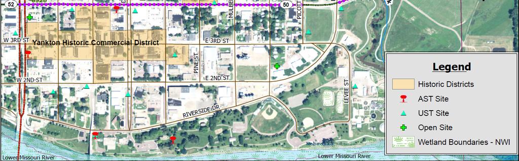
15 Environmental, Social, & Economic Concerns

16 Construction Traffic Control 4 th Street will be closed to traffic in phases Similar to reconstruction of Broadway Ave. Residences adjacent to the project will need to use side streets/alleys during construction Businesses will have accesses maintained as much as practical throughout the construction process 2 nd St Detour option also being considered
17 Tentative Project Schedule Written Comments by April 18 th, 2013 Landowner Meetings Spring 2013 ROW Acquisition process with Landowners Late 2013 thru 2014 Letting December 2014 Construction 2015 and 2016

18 Questions or Comments Submit Comment Forms or Letters by April 18, 2013 Cary Cleland, Road Design Engineering Supervisor South Dakota Department of Transportation 5316 W 60th St N Sioux Falls, SD Cary.Cleland@state.sd.us Public Meeting Information
Mark Malone, P.E. SD DOT
 Mark Malone, P.E. SD DOT SD10 Grading & Surfacing From 8 th Ave W to 8 th Ave E 1 mile plus transition lengths Complete Urban Reconstruction Grading, C&G, Storm Sewer, Sidewalk, Concrete Surfacing Railroad
PROJECT P 0010(91)358 PCN 028U Roberts County
358 PCN 028U Roberts County") Public Meeting/ Open House April 15, 2013 PROJECT P 0010(91)358 PCN 028U Roberts County SD10 - Fm the west city limits to 458th Ave (8th Ave) East in Sisseton Grading & PCC Surfacing, C&G, Lighting, Replace
Public Meeting/ Open House April 15, 2013 PROJECT P 0010(91)358 PCN 028U Roberts County SD10 - Fm the west city limits to 458th Ave (8th Ave) East in Sisseton Grading & PCC Surfacing, C&G, Lighting, Replace
City of Madison, East Johnson Street North Baldwin Street to First Street Local Street Dane County
 City of Madison, East Johnson Street North Baldwin Street to First Street Local Street Dane County Public Involvement Meeting Thursday, April 28, 2016 6 to 8 P.M. Lapham Elementary School 1045 E. Dayton
City of Madison, East Johnson Street North Baldwin Street to First Street Local Street Dane County
 City of Madison, East Johnson Street North Baldwin Street to First Street Local Street Dane County Public Involvement Meeting Thursday, November 10, 2016 5:30 to 7 P.M. Festival Foods 810 E. Washington
Building Great Neighbourhoods BELLEVUE AND VIRGINIA PARK
 Building Great Neighbourhoods BELLEVUE AND VIRGINIA PARK This is Meeting 2 Unfortunately, some residents in Bellevue and Virginia Park received the wrong information for this public open house (Meeting
Fleur Drive Reconstruction
 Fleur Drive Reconstruction October 29, 2018 1 Agenda: Fleur Drive Reconstruction Project Scope & Cost Overview Fleur Drive Cross Section Elements - Travel Lane Widths - Sidewalk Widths - Parkway Widths
S.R. 3009, Section A20 South Park & Logan Road Intersection Improvement Project
 Open House Public Meeting S.R. 3009, Section A20 South Park & Logan Road Intersection Improvement Project Municipality of Bethel Park, Allegheny County Bethel Park Municipal Building 5001 West Library
Frequently Asked Questions
 Frequently Asked Questions Business US 190 in Copperas Cove From Avenue D to Constitution Drive What is access management? A. Access Management is a growing effort by government agencies to improve how
Multimodal Design Guidance. October 23, 2018 ITE Fall Meeting
 Multimodal Design Guidance October 23, 2018 ITE Fall Meeting Introductions Jessica Wilson TDOT Multimodal Division Office of Multimodal Planning Program Supervisor Jessica.L.Wilson@tn.gov Ali Hangul TDOT
West Dimond Blvd Upgrade Jodhpur Street to Sand Lake Road
 West Dimond Blvd Jodhpur St to Sand Lake CSS Transportation Project Summary Municipality of Anchorage Project # 05 005 Project Manager: John Smith, P.E. (MOA PM&E) Project Administrator: Julie Makela,
Building Great Neighbourhoods BONNIE DOON
 Building Great Neighbourhoods BONNIE DOON We Are Here Today To Explain the Neighbourhood Renewal Process Show you the Westwood Preliminary Design Ask for local knowledge Highlight the Local Improvement
The procedures to be followed in undertaking Non-Emergency work depend on the degree of traffic disruption caused by the work.
 APPENDIX G TRAFFIC CONTROL GUIDELINES FOR UTILITY WORK WITHIN ROADWAY RIGHTS- OF-WAY JUNE 2001 Scope of Guidelines These traffic control guidelines cover work performed by utility companies and/or their
U.S. HIGHWAY 50 IMPROVEMENT PROJECT
 U.S. HIGHWAY 50 IMPROVEMENT PROJECT in the City of South Lake Tahoe Project Purpose and Need Planned Improvements Project Cost and Delivery Schedule Proposed Construction Staging Project Partners: HIGHWAY
WYDOT DESIGN GUIDES. Guide for. NHS Arterial (Non-Interstate)
") WYDOT DESIGN GUIDES Guide for NHS Arterial (Non-Interstate) 2014 GUIDE FOR NATIONAL HIGHWAY SYSTEM (NHS) HIGHWAYS (NHS ARTERIALS, Non-Interstate) PRESERVATION REHABILITATION RECONSTRUCTION INTRODUCTION
WYDOT DESIGN GUIDES Guide for NHS Arterial (Non-Interstate) 2014 GUIDE FOR NATIONAL HIGHWAY SYSTEM (NHS) HIGHWAYS (NHS ARTERIALS, Non-Interstate) PRESERVATION REHABILITATION RECONSTRUCTION INTRODUCTION
PROJECT NO. 093 MA 199 H C. FEDERAL NO. xxxx WIKIEUP-WICKENBURG-PHOENIX HIGHWAY TEGNER STREET, ALTERNATIVE 10 PROJECT IMPROVEMENT
 PROJECT NO. 093 MA 199 H 5807 01C FEDERAL NO. xxxx WIKIEUP-WICKENBURG-PHOENI HIGHWAY TEGNER STREET, ALTERNATIVE 10 PROJECT IMPROVEMENT (INTERSECTION IMPROVEMENT) US 93/US 60 FINAL PROJECT ASSESSMENT April
WYDOT DESIGN GUIDES. Guide for. Non-NHS State Highways
 WYDOT DESIGN GUIDES Guide for Non-NHS State Highways 2014 GUIDE FOR Non-NATIONAL HIGHWAY SYSTEM (Non-NHS) STATE HIGHWAYS PRESERVATION REHABILITATION RECONSTRUCTION INTRODUCTION This Guide is directed to
Project NH 0081( )155 PCN 04YQ Codington County. US81 - Intersection of US81 & 20th Ave SE (South Connector) in Watertown. Intersection Improvements
155 PCN 04YQ Codington County. US81 - Intersection of US81 & 20th Ave SE (South Connector) in Watertown. Intersection Improvements") Public Meeting/ Open House May 20, 2014 Project NH 0081( )155 PCN 04YQ Codington County US81 - Intersection of US81 & 20th Ave SE (South Connector) in Watertown Intersection Improvements The South Dakota
Public Meeting/ Open House May 20, 2014 Project NH 0081( )155 PCN 04YQ Codington County US81 - Intersection of US81 & 20th Ave SE (South Connector) in Watertown Intersection Improvements The South Dakota
Poor pavement condition Substandard Intersections. / Substandard bike/pedestrian/transit accommodations. Driveway access Environmental concerns
 Public Informational Meeting University Avenue (Allen Boulevard Segoe Road) March 23, 2011 City of Madison City of Middleton Village of Shorewood Hills Dane County Existing Roadway Conditions Poor pavement
Attached for your reference please find project updates on ongoing VDOT construction projects in Southampton County.
 SOUTHAMPTON COUNTY BOARD OF SUPERVISORS Regular Session i July 25, 2016 6. HIGHWAY MATTERS A. PLAN PROJECT UPDATES Attached for your reference please find project updates on ongoing VDOT construction projects
CHAPTER 16 PEDESTRIAN FACILITIES DESIGN AND TECHNICAL CRITERIA TABLE OF CONTENTS
 CHAPTER 16 PEDESTRIAN FACILITIES DESIGN AND TECHNICAL CRITERIA TABLE OF CONTENTS Section Title Page 16.1 General... 16-1 16.1.1 AASHTO Reference... 16-1 16.1.2 ADA Requirements... 16-1 16.2 Sidewalks...
CONNECTIVITY PLAN. Adopted December 5, 2017 City of Virginia Beach
 CONNECTIVITY PLAN Adopted December 5, 2017 City of Virginia Beach CONTENTS 1.0 Background & Purpose... 2 2.0 Existing Inventory & Analysis... 3 ViBe District Existing Walking Conditions... 4 3.0 ViBe District
Brooklyn Boulevard (County Road 152) Reconstruction Project Phase I. OPEN HOUSE June 20, 2017
 Reconstruction Project Phase I. OPEN HOUSE June 20, 2017") Brooklyn Boulevard (County Road 152) Reconstruction Project Phase I OPEN HOUSE June 20, 2017 Brooklyn Boulevard (County Road 152) Phase I Project Partners Project Lead Other Project Partners include Brooklyn
Brooklyn Boulevard (County Road 152) Reconstruction Project Phase I OPEN HOUSE June 20, 2017 Brooklyn Boulevard (County Road 152) Phase I Project Partners Project Lead Other Project Partners include Brooklyn
Cincinnati Dayton Rd Widening
 Cincinnati Dayton Rd Widening Project Overview Widening of Cincinnati Dayton Rd to four lanes - providing a center turn lane and an additional northbound lane Realignment of Station Rd Widening of bridge
MIAMI & ERIE CANAL SHARED USE TRAIL
 New Bremen, Ohio Survey Transportation Engineering Grant Writing Project Cost Engineers Estimate: $509,358 Bid Amount $480,892 Size 1.12 miles $597,696 ODOT TEP $249,815 ODNR Completion Projected 11/15/14
Design Criteria. Design Criteria
 F Design Criteria Design Criteria Ministry of Transportation Ministère des Transports DESIGN CRITERIA Page: 1 of 13 WORK PROJECT NO. N/A GO Bloomington Station TYPE OF PROJECT LOCATION Bloomington Road
Building Great Neighbourhoods QUEEN ALEXANDRA
 Building Great Neighbourhoods QUEEN ALEXANDRA We are here today to Explain how the City is investing in improving your neighbourhood and how your neighbourhood will be improved to meet current City standards.
Building Great Neighbourhoods LANSDOWNE
 Building Great Neighbourhoods LANSDOWNE We are here today to Explain how the City is investing in improving your neighbourhood and how your neighbourhood will be improved to meet current City standards.
PROJECT OBJECTIVES. Improve vehicle capacity for the intersection. Improve pedestrian and bicycle access
 COMMUNITY MEETING Project Update March 15, 2010 Purcellville, Virginia OVERVIEW Project need / objectives Project recap Design elements Proposed improvements Summary of project benefits / next steps PROJECT
Making the Right Call in Sisseton. Mark Malone, PE SD DOT
 Making the Right Call in Sisseton Mark Malone, PE SD DOT Why are we here again? Review past meetings Discuss Comments SDDOT received How has SDDOT addressed the public s concerns Options to move forward
Bicycle and Pedestrian Connectivity Study. Old Colony Planning Council
 Bicycle and Pedestrian Connectivity Study Old Colony Planning Council Outline Why consider bike/peds in road designs? Why are measures needed? Connecting Land Use with Transportation Evaluation Tools:
MILEGROUND - AIRPORT ROAD. Fall 2018/ Spring Fall 2020 TBD. US 119 Monongalia County HOW WILL TRAFFIC CONTROL BE HANDLED: KNOW BEFORE YOU GO
 MILEGROUD - AIRPORT ROAD US 119 Monongalia County The Mileground - Airport Road project on US 119 involves upgrading the three-lane facility to a five-lane facility to help eliminate congestion and improve
PERFORMANCE ACTIVITY 613 IMPACT ATTENUATOR WORK DESCRIPTION 3
 PERFORMANCE ACTIVITY 613 IMPACT ATTENUATOR WORK DESCRIPTION 1 WORK DESCRIPTION 2 WORK DESCRIPTION 3 Install Remove Repair 613 IMPACT ATTENUATOR ACTIVITY DESCRIPTION Repair, install, remove and maintain
Clinton Street Bridge over the Maumee River. ODOT Project DEF April 1, 2015 Stakeholder s Meeting
 Clinton Street Bridge over the Maumee River ODOT Project DEF-15-14.77 April 1, 2015 Stakeholder s Meeting Purpose of Stakeholder Meeting Review the project and why it s happening Share the results of the
Hospital Link Project Project Update September 2017
 Hospital Link Project Project Update September 2017 General The project provides a link from Riverside Drive and the Transitway to the Hospital Link Road. Construction is well underway. Read on for important
Information on display. Inside this handout. Triangle Area revisions. Project need displays. Preferred alternative on aerial maps
 Public information meeting #4 4 to 7 p.m., September 30, 2009 Hales Corners Welcome Thank you for attending this public information meeting for the WIS 100 Corridor Study. Your interest and comments are
Atwood Avenue Fair Oaks Avenue Cottage Grove Road
 Atwood Avenue Fair Oaks Avenue Cottage Grove Road Agenda Purpose Review project scope & goals Present design alternatives Gather feedback Answer Questions Format Open House Presentation Q&A Open House
Programmatic Categorical Exclusion Update Question & Answers
 Office of Environmental Stewardship 395 John Ireland Blvd St. Paul, MN 55155 Programmatic Categorical Exclusion Update Question & Answers Date: October 2017 OPTIONAL District/Division Nam This FAQ document
RZC Appendix 8A Marymoor Subarea Street Requirements
 RZC Appendix 8A Marymoor Subarea Street Requirements For additional design details for Marymoor Subarea infrastructure, refer to the 2017 Marymoor Subarea Infrastructure Planning Report. STREET REQUIREMENTS
Public Involvement Outreach Requirements for Public Information Open House Meeting: C.N , HSIP-5003(12) 132 nd and West Center Road, Omaha
 132 nd and West Center Road, Omaha") To: NDOR Environmental From: Randy McCart, HDR Date: 4 April 2017 RE: Public Involvement Summary Report, HSIP-5003(12) 132 nd and West Center Road, Omaha; C.N. 22629 Public Involvement Outreach Requirements
To: NDOR Environmental From: Randy McCart, HDR Date: 4 April 2017 RE: Public Involvement Summary Report, HSIP-5003(12) 132 nd and West Center Road, Omaha; C.N. 22629 Public Involvement Outreach Requirements
DRAFT. System Components. Greenway Trails. Introduction. Trail Types. Zebulon Greenway Master Plan
 5 System Components Wakefield Street Photo Simulation showing Sharrows Introduction The Master Plan identifies various system components that, together, create a comprehensive greenway system. These components
Public Information Meeting. Orange Camp Road. Dr. Martin Luther King Jr. Beltway to I-4. Presented by: Volusia County August 2, 2018
 Public Information Meeting Orange Camp Road Dr. Martin Luther King Jr. Beltway to I-4 Presented by: Volusia County August 2, 2018 1 Project Goals To improve the operations and safety for Orange Camp Road
Legislative Update Williamsburg Residency
 Hampton Roads District Legislative Update Williamsburg Residency Jim Brewer, Resident Administrator 757-253-5140 Projects Under Way Warwick Boulevard Project http://www.warwickboulevard.org/ Contractors:
Roadway Classification Design Standards and Policies. Pueblo, Colorado November, 2004
 Roadway Classification Design Standards and Policies Pueblo, Colorado November, 2004 Table of Contents Page Chapter 1. General Provisions 1.1 Jurisdiction 3 1.2 Purpose and Intent 3 1.3 Modification 3
Hennepin County Transportation Department
 Hennepin County Transportation Department Complete Streets Design and Implementation Prepared for the Complete Streets Task Force Craig Twinem, P.E. Design Division Manager Tom Johnson, P.E. Transportation
SECTION 14: LANDSCAPING AND BEAUTIFICATION
 SECTION 14: LANDSCAPING AND BEAUTIFICATION RULE 14.1 GENERAL PROVISIONS 14.1.1 The rules and guidelines contained in this section have been established to provide proper guidelines for the beautification
MONTGOMERY COUNTY PLANNING DEPARTMENT
 MONTGOMERY COUNTY PLANNING DEPARTMENT THE MARYLAND-NATIONAL CAPITAL PARK AND PLANNING COMMISSION MCPB Item No Date: 6-07-2018 MD355 Over Little Bennett Creek Bridge Replacement (SHA Project No. MO4275180),
This Chapter sets forth the minimum design, technical criteria and specifications to be used in the preparation of all roadway plans.
 4.1 GENERAL This Chapter sets forth the minimum design, technical criteria and specifications to be used in the preparation of all roadway plans. These Roadway Standards are for new construction and modification
GDOT Cross Section Elements. Course ID: GDOT PDH Credits
 GDOT Cross Section Elements Course ID: GDOT-01 2 PDH Credits Civil Engineer Educators LLC 1026 Timberwolf Lane Juneau, AK 99801 Email: support@civilpdh.com Chapter 6 Contents 6. CROSS SECTION ELEMENTS
FY STATEWIDE TRANSPORTATION IMPROVEMENT PROGRAM New Jersey Department of Transportation Projects
 ROUTE/ Project ID No. TIP No. Electrical Load Center Replacement - North 04324 04324 This project will provide for the betterment of the existing highway lighting facilities located along Routes 3, 17
UPDATES 11/14/2018: 10/25/2018: CLOSED 10/22/2018: 10/12/2018: 10/05/2018: 09/27/2018:
 Veterans Boulevard (formerly Boundary Road) This two-year construction project will widen and pave all of Veterans Boulevard. In 2017, the first portion of the road from Highway 16A to 44 Avenue was completed.
Final Sidewalk Feasibility Study
 Garfield Drive From Anastasia Drive to Elizabeth Place City of South Daytona July 23, 2009 Final Sidewalk Feasibility Study Prepared for: Prepared by: Final Sidewalk Feasibility Study Garfield Drive 2
Weymouth - Abington Route 18 Widening and Reconstruction Project File No
 Weymouth - Abington Route 18 Widening and Reconstruction Project File No. 601630 PROJECT LOCATION Project Limit Previously Completed Signalized Intersections (Typical) Route 18 Widening Bridge No. W-32-013
BPP / SUB
 Development Services Department Project/File: Lead Agency: Site address: Millwell Place Subdivision/ BPP15-0031/ SUB15-0064 This is a preliminary plat application to allow for the development of 68 building
Water Street Promenade. Engineering and Design Services. Public Information Meeting No. 2. Education / Infrastructure / Innovation. Maplewood Avenue &
 Public Information Meeting No. 2 Water Street Promenade Maplewood Avenue & Engineering and Design Services Adjacent Areas July 16,2014Portsmouth, NH May 10, 2016 Education / Infrastructure / Innovation
5 CIRCULATION AND STREET DESIGN
 5 CIRCULATION AND STREET DESIGN This chapter describes circulation and streetscape improvements proposed for the Northwest Chico Specific Plan Area. It includes detailed design specifications for existing
Improvements Infrastructure Gap Assessment and Improvements Street Striping
 Infrastructure Project Proposal The federal-aid Safe Routes to School program funds infrastructure/engineering projects that fall into two categories: Design (available only to School Development Authority
CSAH 101 Preliminary Design
 CSAH 101 Preliminary Design Public Open House No. 2 January 29, 2013 CSAH 62 to Hutchins Drive Welcome / Introductions Hennepin County Craig Twinem, Transportation Maury Hooper, Transportation Nick Peterson,
LARIMER COUNTY: ENGINEERING DOUGLAS ROAD (CR 54)
") LARIMER COUNTY: ENGINEERING DOUGLAS ROAD (CR 54) INTRODUCTIONS * Pipeline 1041 Application Coordinator Todd Blomstrom Public Works Director Mark Peterson County Engineer Terry Gilbert Community Development
LARIMER COUNTY: ENGINEERING DOUGLAS ROAD (CR 54) INTRODUCTIONS * Pipeline 1041 Application Coordinator Todd Blomstrom Public Works Director Mark Peterson County Engineer Terry Gilbert Community Development
2011 Capital Projects University Area - Community Council Priority List Municipality of Anchorage
 2011 Capital Projects University Area - Community Council Priority List Municipality of Anchorage 2 Project Management and Engineering Projects on 40th Ave Extension - Lake Otis Pkwy to Dale St $18,103,000
Driveway Design Criteria
 Design Manual Chapter 5 - Roadway Design 5L - Access Management 5L-4 Driveway Design Criteria A. General For efficient and safe operations, access drives and minor public street intersections can be improved
May 10, 2013 Meredith Cruz, (561) Palm Beach County Traffic Report May 10 through May 17, 2013
 Palm Beach County Traffic Report May 10 through May 17, 2013") May 10, 2013 Meredith Cruz, (561) 641-6440 mcruz@corradino.com Palm Beach County Traffic Report May 10 through May 17, 2013 Palm Beach County Palm Beach County traffic will be affected this week by ongoing
May 10, 2013 Meredith Cruz, (561) 641-6440 mcruz@corradino.com Palm Beach County Traffic Report May 10 through May 17, 2013 Palm Beach County Palm Beach County traffic will be affected this week by ongoing
CITY OF KASSON TRANSPORTATION ALTERNATIVES KASSON SAFE ROUTES TO SCHOOL
 ve ha 8t G B A Mantorville Ave N 240th Ave 16th St NE 11th Ave NE K-M HIGH SCHOOL SUNRISE TRAIL TO MANTORVILLE MNTH 57 SUNSET TRAIL TO MANTORVILLE NE PARK 16TH ST NE TRAIL K-M ELEMENTARY SCHOOL K-M MIDDLE
APPENDIX A: Complete Streets Checklist DRAFT NOVEMBER 2016
 APPENDIX A: Complete Streets Checklist DRAFT NOVEMBER 2016 Complete Streets Checklist MetroPlan Orlando s Complete Streets Checklist is an internal planning tool for staff to further implementation of
Highway 49, Highway 351 and Highway 91 Improvements Feasibility Study Craighead County
 Highway 49, Highway 351 and Highway 91 Improvements Feasibility Study Craighead County Executive Summary March 2015 Highway 49, Highway 351 and Highway 91 Improvements Feasibility Study Craighead County
APPENDIX L. Design Criteria
 APPENDIX L Design Criteria DRAFT PRELIMINARY DESIGN CRITERIA Page 1 of 18 APPROVALS MANAGER, ENGINEERING CITY OF HAMILTON MANAGER, ENGINEERING REGION OF HALTON DATE This Design Criteria for the New East-West
Project Update May 2018
 Project Update May 2018 Dakota County, in cooperation with the City of Lakeville, is planning to reconstruct 202 nd Street West (County Road 50) from Holyoke Avenue to Cedar Avenue (County Road 23). 202
Operations -- Transit From: N/A To: N/A. Improvement Type: Regionally Significant: No
 Central Puget Sound Regional 2017-2020 Transportation Improvement Program Amendments and Corrections to be included in the 2017-20 STIP PSRC's Amendment 2017-08 County: King List of 17-08 Amendment Projects:
Mandan Commission Meeting August 2, 2016 Mandan City Hall
 Mandan-Bismarck Corridor Improvement Study Mandan Commission Meeting August 2, 2016 Mandan City Hall 2014 HDR, Inc., all rights reserved. Mandan Corridors Study Schedule 2015 2016 Study Kick Off August
Designing Pedestrian Facilities for Accessibility. Module 8 Maintenance of Pedestrian Facilities and Alternate Pedestrian Access Routes in Work Zones
 Designing Pedestrian Facilities for Accessibility Module 8 Maintenance of Pedestrian Facilities and Alternate Pedestrian Access Routes in s Maintenance of Accessible Features Title II (28 CFR 35.133(a))
ADA on Construction. Guidance for Section C Plan Preparers
 ADA on Construction Guidance for Section C Plan Preparers Some impacts cannot be avoided and those impacts apply to residents, businesses, motorists, and pedestrians alike. However, good planning can minimize
Paul Vraney Bureau of Project Development 02/11/2016
 Paul Vraney Bureau of Project Development 02/11/2016 ADA background & alterations definition Design considerations Provide sufficient layout data Curb ramp selection Maximum curb ramp and gutter slopes
Complete Streets Policy DAVID CRONIN, P.E., CITY ENGINEER
 Complete Streets Policy DAVID CRONIN, P.E., CITY ENGINEER Complete Streets City Commission adopted a Complete Streets policy in 2012 Complete Streets are road networks that are designed for all users:
Accommodating Pedestrians in the Work Zone
 Accommodating Pedestrians in the Work Zone Guidance for Section C Plan Preparers Some impacts cannot be avoided and those impacts apply to residents, businesses, motorists, and pedestrians alike. However,
General Plan Circulation Element Update Scoping Meeting April 16, 2014 Santa Ana Senior Center, 424 W. 3rd Street, Santa Ana, CA 92701
 General Plan Circulation Element Update Scoping Meeting April 16, 2014 Santa Ana Senior Center, 424 W. 3rd Street, Santa Ana, CA 92701 Meeting Agenda 1. Purpose of Scoping Meeting 2. Project Overview 3.
TOWN OF PALM BEACH FOR IMMEDIATE RELEASE. Patricia Strayer, P.E., Town Engineer Phone: ,
 TOWN OF PALM BEACH DATE: November 9, 2018 FOR IMMEDIATE RELEASE MEDIA CONTACT: Patricia Strayer, P.E., Town Engineer Phone: 561-838-5440, Email: pstrayer@townofpalmbeach.com Construction & Traffic Highlights
Pedestrians safety. ROAD SAFETY SEMINAR PIARC/AGEPAR/GRSP Lome, Togo October 2006 Lise Fournier, Canada-Qu
 Pedestrians safety ROAD SAFETY SEMINAR Lome, Togo October 2006 Lise Fournier, Canada-Qu Québec Contents WHO s data Risk factors Pedestrian needs Pedestrian facilities Conclusion Source: WHO WHO reports
Access requests to County streets and roadways are processed through one of the following methods:
 13.1 GENERAL APPLICATION PROCESS Access requests to County streets and roadways are processed through one of the following methods: A. Planned Developments may set general locations for access points.
SECTION 3 STREET DESIGN
 3.01 GENERAL SECTION 3 STREET DESIGN For purposes of geometric and structural design, streets shall be classified according to the following table. The City Engineer will determine the class of all proposed
122 Avenue: 107 Street to Fort Road
 : 107 Street to Fort Road November 24, 2015 4:30 8:00 p.m. Meeting Purpose Summarize project work completed to date Share results of public input from Phase 1 Share the draft concept plan and proposed
TRANSPORTATION ALTERNATIVES PROGRAM: SELECTED PROJECTS AND FUNDING ALLOCATIONS
 ITEM #9: TRANSPORTATION ALTERNATIVES PROGRAM: SELECTED PROJECTS AND FUNDING ALLOCATIONS The Transportation Alternatives Program (TAP) created by MAP-21 requires that 50% of the program funds received by
Chapter 4: Funding and Implementation
 Chapter 4: Funding and Implementation 83 84 Cost Estimating Cost estimating is an iterative process. When a project is in the conceptual stage, preliminary cost estimates are also provided conceptually,
Citywide Sidewalk and Crosswalk Programs
 Citywide Sidewalk and Crosswalk Programs Council Meeting October 20, 2015 Presented by Rita Hu and Jamal Mahmoud Program Goals Implement the City s comprehensive plan. Provide pedestrian with safe walking
Street Paving and Sidewalk Policy
 City Commission Policy 600 Street Paving and Sidewalk Policy DEPARTMENT: Public Works DATE ADOPTED: June 7, 1995 DATE OF LAST REVISION: December 10, 2014 Policy No. 600.01 AUTHORITY: PASS City of Tallahassee-Leon
ADA Design Overview. Section 2. ADA Design Overview. Pedestrian Access Routes. Pedestrian Access Routes. Overview
 ADA Design Overview Section 2 ADA Design Overview Overview Accessible Pedestrian Signals Alternate Fall, 2017 Ann Johnson, PE Services Brady Rutman, SRF Consulting Group 2 Pedestrian Access Route (PAR)
5. RUNNINGWAY GUIDELINES
 5. RUNNINGWAY GUIDELINES These guidelines should be considered collectively when making runningway decisions. A runningway is the linear component of the transit system that forms the right-of-way reserved
ACTIVE TRANSPORTATION
 ACTIVE TRANSPORTATION Mobility 2040 Supported Goals Improve the availability of transportation options for people and goods. Support travel efficiency measures and system enhancements targeted at congestion
St. Francis Drive through the City of Santa Fe Corridor Study
 VII. ENGINEERING AND ENVIRONMENTAL EVALUATION TRAIL CONNECTIVITY In the southern portion of the Corridor there is a lack of a sidewalk, trail or bicycle facility within the right-ofway. However, the City
Municipal Class EA To Address Traffic Congestion On The Ontario Street Corridor (Grand Bend) Public Information Meeting June 4, 2018
 Public Information Meeting June 4, 2018") Municipal Class EA To Address Traffic Congestion On The Ontario Street Corridor (Grand Bend) Public Information Meeting June 4, 2018 Background Agenda Traffic Study Update Class EA Alternatives Bridge
Municipal Class EA To Address Traffic Congestion On The Ontario Street Corridor (Grand Bend) Public Information Meeting June 4, 2018 Background Agenda Traffic Study Update Class EA Alternatives Bridge
Building Great Neighbourhoods STRATHEARN
 Building Great Neighbourhoods STRATHEARN Public Involvement Community League Meeting #1: October 5, 2015 Public Meeting #2: March 15, 2016 Public Meeting #3: January 17, 2017 Building Great Neighbourhoods
CTH M HIGHWAY PROJECT CTH Q to STH 113
 CTH M HIGHWAY PROJECT CTH Q to STH 113 PUBLIC INFORMATIONAL MEETING #3 Wednesday, May 25, 2005 Town of Westport Administration Building 5387 Mary Lake Road 6:00 p.m. to 8:00 p.m. PUBLIC INFORMATIONAL MEETING
SIOUX FALLS MPO 2018 OBLIGATED TRANSPORTATION IMPROVEMENT PROJECTS
 TOTAL LETTING DATE AWARD DATE NOTES Interstate Maintenance s 2.00 IM 0020(155) 04X N McCook Minnehaha 0.0 Mitchell Region on I90 Scour Protection $873,000 $960,000 Cancelled $0 $0 Minor Arterial 1.00 Minor
Basalt Creek Transportation Refinement Plan Recommendations
 Basalt Creek Transportation Refinement Plan Recommendations Introduction The Basalt Creek transportation planning effort analyzed future transportation conditions and evaluated alternative strategies for
ADA PRESENTATION (CURB RAMPS)
") ADA PRESENTATION (CURB RAMPS) ACECNJ/NJDOT/FHWA DESIGN SUMMIT Warren Howard New Jersey Department of Transportation May 21, 2013 ADA Curb Ramps NJDOT wants curb ramps to be designed & constructed properly
ADA PRESENTATION (CURB RAMPS) ACECNJ/NJDOT/FHWA DESIGN SUMMIT Warren Howard New Jersey Department of Transportation May 21, 2013 ADA Curb Ramps NJDOT wants curb ramps to be designed & constructed properly
4APNOIPF Vh, YII PTC CITY COUNCIL AGENDA REPORT. Honorable Mayor and City Council Members. 8K TH 63 River Crossing Bridge Replacement Project
 City of RE 4APNOIPF Vh, X` W\ YII PTC ING, CITY COUNCIL AGENDA REPORT Council Meeting Date: September 26, 2016 To: From: Agenda Item: Honorable Mayor and City Council Members Ron Rosenthal, Engineering
IL Route 71 Construction Update
 100 Parkers Mill Oswego, IL. 60543 (630) 554-3618 4.20.16 IL 71 TRAFFIC ADVISORY: Tentatively scheduled for April 21st A new traffic pattern from Paradise to Wolf Crossing on IL 71 will be in use. The
City of Gainesville Transportation/Roadway Needs PROJECT SUMMARY
 A1 Roadway Resurfacing $23,846,000 TYPE: Preservation of existing system Roadway resurfacing A2 Signal Replacement $6,000,000 TYPE: Preservation of existing system Replace traffic signals. B1 W 6th St
Preparing a Curb Ramp Project. December 15, 2010
 Preparing a Curb Ramp Project December 15, 2010 3 Tiers of Project Types Non-Signalized Curb Ramp Reconstruction - Typically utilizing standard plans and identifying ramp types at each quadrant Signalized
City Avenue Projects
 City Avenue Projects City Avenue Special Services District Conceived in the early 1990 s Lita Cohen, Jim Ettelson, Joe Manko, and Michael Nutter Saint Joseph s provided key start-up support. True Public/Private
Henderson Ave. Complete Streets Project
 Henderson Ave. Complete Streets Project Meeting Purpose To finalize conceptual components of project prior to proceeding with preliminary engineering www.dallascompletestreets.wordpress.com MeetingAgenda
TRASBURG RANSPORTATION
 TRASBURG RANSPORTATION LAN DEVELOPED BY THE TRANSPORTATION PLANNING DIVISION OF THE VIRGINIA DEPARTMENT OF TRANSPORTATION IN COOPERATION WITH THE U.S. DEPARTMENT OF TRANSPORTATION, FEDERAL HIGHWAY ADMINISTRATION