Re: Paradise Springs, Municipality of Grey Highlands Transportation Review. C.C.Tatham & Associates Ltd. Consulting Engineers
|
|
|
- Patience Gregory
- 5 years ago
- Views:
Transcription
1 5 Sandf ord Fleming Drive, Sulle 200 C.C.Tatham & Associates Ltd. Consulting Engineers Collingwood Bracebridge 0rillia Collingwood, 0ntario LgY 546 Tel: (705) Fax: (705) inf Web: September 25,202 via mail & CCTA File 232 0ro Ridge Corp, 32 Ellsworth Avenue Richmond Hill, ON L4C N8V Re: Paradise Springs, Municipality of Grey Highlands Transportation Review Dear Sir: As requested, we have prepared a transportation review for the proposed Paradise Springs development on Osprey-The Blue Mountains Townline in the Municipality of Grey Highlands, This review examines the following:. development proposal and truck traffic;. recommended haul route;. existing road conditions along the haul route;. sight lines and visibility along the haul route; and, need for improvements. Development Proposul & Truck Truffic The proposed development is a water loading facility located on Osprey-Blue Mountains Townline west of Road 45 in the Municipality of Grey Highlands, The site location is shown in Figure. The site operated as a water taking facility in the 990s. ln 2006, applications were made by a previous owner for a facility to support an operating level of 2,320litres per day, Since this time, the ownership of the property has changed, The new owner, Oro Ridge Corp., is proposing a facility with water extraction limited to 49,000 litres per day. Ø Xfnonal Engineers Authorized by the Association of Professionat Ensineers of 0ntario ro offer proressionat ensineerins services. e iljj?j:iit
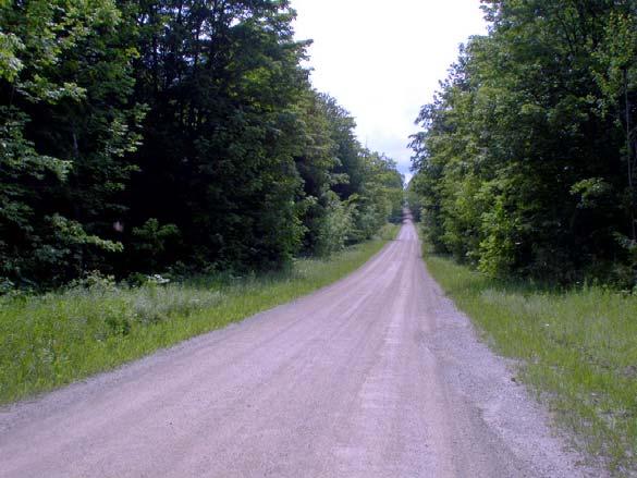
2 Based on a truck capacity of 40,000 to 50,000 litres, the site is expected to generate load per day, resulting in one truck trip to the site (empty) and truck trip from the site (loaded). Recommended Haul Route As part of the previous application, a transportation review was undertaken whereby several alternative haul routes were evaluated based on sightlines, avoidance of built-up areas, road conditions, and other factors. The preferred haul route, which remains applicable to the current proposal, is illustrated in Figure. The preference for this haul route was also noted by Municipality of Grey Highlands and the Town of The Blue Mountains given safety concerns relative to some of the intersections on the alternative Grey Road 3 haul route considered. It is also noted that further to the initial study, Simcoe Road 9 has been identified for closure between Townline and Simcoe Road 24. While this road section does not lie along the preferred haul route, it was part of the Grey Road 3 haul route. Apart from the use of local road (which is not preferred), the noted haul route is the only feasible route. Existing Road Conditions As evident in Figure, the majority of the haul route is comprised of County roads (Grey County Roads 2 and 4, and Grey/Simcoe County Road 24). These roads are intended to serve longer distance travel, all vehicle types (including trucks) and greater traffic volumes. As such, their use by trucks travelling to/from the site (2 per day) is considered appropriate. For those remaining road sections along the haul route that are considered local roads, additional details are noted in Table. Table : Road Conditions Preferred Haul Route Osprey-The Blue Mountains Townline Road 45 2 th Concession B Length 0.5 km 2.0 km 2.05 km Platform Width 5.0 m 5.0 m 7.9 m platform 6.4 m paved surface Surface gravel gravel paved Daily Traffic < 300 estimated < 300 estimated < 300 estimated Posted Speed not posted not posted 80km/h Topography rolling rolling rolling Paradise Springs Transportation Review. Cansult Tatham Transportation Consultants, January 25, Oro Ridge Corp. Page 2 of 8 September 25, 202
3 Through a supplementary field visit and visual inspection in July 202, it was noted that all roads are in good structural condition. The two gravel roads, Townline and Road 45, appear to have been recently graded (including fresh gravel on Road 45). While the platform widths of these roads are noted as 5.0 metres, there appear to be gravel shoulders on either side that are simply overgrown (the roads were likely constructed initially to a width of 6.0 metres). Photographs are provided in Figure 2. With respect to speed limits, only 2 th Concession B is posted (80 km/h). No speed limit signs are otherwise posted on Townline or Road 45 and thus an 80 km/h speed limit has been assumed (as typical in rural areas not otherwise posted). Available Sight Lines Following the initial transportation review, additional field investigations were undertaken in June 2008 to determine sight lines at the existing driveways along Townline and Road 45 (as identified in Figure 3), in response to concerns raised by the Municipality of Grey Highlands. These concerns related specifically to whether or not residents leaving their driveways can see oncoming trucks and can those same trucks see the residents. MTO geometric design guidelines dictate that sight lines should be measured from the height of the turning vehicle driver s eye of.05 metres to the top of the approaching vehicle.3 metres above the road. It is recognized however that trucks are somewhat taller than typical automobiles and thus will be more visible upon approach. In this regard, a height of.6 metres has been employed as opposed to.3 metres (which is still considered to be conservative in that the eye height of a truck driver is typically in the order of 2.6 metres and truck heights are in the order of 4 metres). The resulting sight lines at the noted access points are summarized in Table 2, whereas corresponding photographs are noted in Figure 2. In most cases, the sight lines are restricted by the vertical alignment of the road. With respect to the sight lines for trucks to observe cars exiting the driveways, a higher eye height would be applicable for trucks (ie. 2.6 metres) with the object height being in the order of.05 to.3 metres (ranging from the driver to the roofline). However, to maintain a conservative approach, the sight lines of Table 2 have also been applied. As noted, the existing sight lines are typically in the order of 00 to 200 metres. The sight line to the south as observed at Location : Driveway on Road 45 is noted as 30 metres, which corresponds to the intersection of Road 45 with 2 th Concession B (ie. the intersection is approximately 30 metres south of the driveway). While sight lines further south on Road 45 exist (as evident in the photographs of Figure 2), the designated haul route will result in trucks arriving from the east along 2 th Concession B and thus will only become evident as they turn the corner at the intersection. Similarly, at Location 6: Quarry driveway on Townline, the sight line to the east is noted as 20 metres which is the approximate distance to the Road 45 intersection (a greater sight distance to the east exists, as evident in the photos of Figure 2). Trucks will approach the site from Road 45 and thus will only be evident upon approach to the intersection, at which time they must stop at Townline Oro Ridge Corp. Page 3 of 8 September 25, 202
4 (Road 45 is stop controlled). In either case, a truck turning through these intersections would do so at a reduced speed and thus it is not considered critical. Table 2: Sight Lines at Driveways Access Location Road 45 Townline to/from N to/from S to/from W to/from E Driveway on Road metres 30 metres Driveway on Road > Driveway on Road Driveway on Road Driveway on Road Quarry Driveway (20m west of Road 45) on Townline - - >200 metres 20 metres 7 Driveway on Townline Site access on Townline these access points are in close proximity to intersections and thus the distances noted correspond to the distance to the intersection; an approaching truck will only be evident as they arrive at the intersection Sight Line Assessment In considering the appropriateness of the sight lines, the following must be considered: Level of standard: which standard (ie. stopping sight distance, turning sight distance, or some other measure) should be required? Design speed: what design speed should be assumed for Road 45 and Townline? Flexibility: what amount of deviation from the standard is permissible (noting that in certain circumstances, the relevant design guidelines allow features that are substandard to some extent)? Level of Standard The most appropriate standard to be applied is stopping sight distance, which is the minimum distance required for a vehicle to observe a hazard in the road and bring their vehicle to a complete stop. In the application being considered, the hazard would be the vehicle exiting the driveway (assuming that it would stall in the path of the oncoming vehicle as opposed to continuing on its path). The corresponding stopping sight distance requirements are provided in Table 3 based on Ministry of Transportation of Ontario (MTO) and Transportation Association of Canada (TAC) standards. It is noted that the latter provides stopping sight distances specific to trucks (assuming conventional Oro Ridge Corp. Page 4 of 8 September 25, 202
5 braking systems vs anti-lock brakes). It is generally accepted however that the increased stopping distance requirements for trucks are offset by the increased driver eye height through vertical curves. Notwithstanding, as we have considered higher object heights corresponding to a truck, the truck requirements have been applied. Table 3: Stopping Sight Distance Requirements Design Speed MTO cars TAC cars TAC trucks 2 50 km/h 65 metres metres 85-0 metres also reflects requirements for trucks with anti-lock brakes 2 reflects trucks with conventional brakes In considering the available sight distances in relation to the truck requirements, they satisfy the 70 km/h design speed requirements at all but 2 locations, where the sight lines are 20 and 90 metres (corresponding to design speeds of 60 and 50 km/h respectively). Should a greater visibility height for an approaching truck be considered, these design speeds would increase accordingly. In considering the requirements for cars, the existing sight lines correspond to design speeds of 60 to 00 km/h. It is noted that the sight distance requirements of Table 3 reflect stopping on wet asphalt with poor tire traction. In previous review comments from the Municipality, it was noted that braking distance on gravel may be 40% higher than on wet asphalt. However, as further noted in the comments, the coefficient of friction otherwise employed by MTO for wet asphalt is consistent with that used in studies pertaining to gravel surfaces and thus the MTO criteria can be applied. TAC standards are considered comparable to MTO. Further to stopping sight distance, previous Municipal comments made reference to the need to provide departure/turning sight distance in accordance with the MTO Commercial Access Standards. For a design speed of 80 km/h, the requirement is 80 metres. This requirement pertains specifically to a vehicle turning left onto a 2-lane road across a vehicle approaching from the left (it is such that the approaching vehicle would not have to adjust their travel speed). Given the haul route, we do not anticipate any left turns from the site and thus this criterion would not apply at the site access. While it may be desirable to apply this same criterion to private driveways, there is no such requirement in either the MTO or TAC standards. Furthermore, we do not believe that this is necessary in context of the traffic volumes on Townline and Road 45, including truck volumes, and the amount of activity at the Oro Ridge Corp. Page 5 of 8 September 25, 202
6 driveways. We do not believe it to be a significant matter should approaching vehicles be required to adjust their speed. Provided that stopping sight distance is achieved, vehicles have an opportunity to avoid any collision. Furthermore, as vehicles pull out of their driveway they will continue to travel and accelerate and thus will not be standing still. Design Speed & Posted Speed The selection of the appropriate sight distance requirement is predicated on the design speed, which is turn is based on the posted speed. For Townline and Road 45, which have an assumed speed limit of 80 km/h as not otherwise posted, a design speed of 80 to 00 km/h would be typical (usually it is 0 to 20 km/h over the posted speed but can equal the speed limit). However, it is evident from the sight line assessment that the existing topography along these roads is not conducive to an 80 km/h posted speed (regardless of whether the proposed development proceeds). Based on the car criteria, the design speed is as low as 60 km/h. To determine an appropriate speed limit, both Townline and Road 45 were reviewed in accordance with the TAC Automated Speed Limit Guidelines, and considering road alignment, surface type, number of intersections and driveways and presence of roadside hazards. In both cases, the review recommends a posted speed of 60 km/h (worksheets are attached). Through the course of our field visits, it appears that speeds on both Townline and Road 45 are generally low, reflective of the gravel surfaces, narrow widths, rural environments and overall topography through the area. In consideration of the above, a posted speed of 60 km/h is considered appropriate. The MTO Geometric Design Standards for Ontario Highways provides the following guidance for the selection of a design speed: A design speed equal to the maximum posted speed is accepted where warranted by such factors as low traffic volumes, rugged terrain and economic considerations. This practice would be more appropriate for minor collector and local roads. As the characteristics of Townline and Road 45 are in keeping with a rural local road classification, a design speed of 60 km/h or 70 km/h is considered appropriate. Flexibility of Design Standard Regarding flexibility of the design standard, the MTO Geometric Design Standards for Ontario Highways provides the following guidance: Where a minor secondary highway has a generally substandard alignment and advisory and warning signs have proven ineffective, consider: Oro Ridge Corp. Page 6 of 8 September 25, 202
7 a) where no improvements are warranted - reducing the legal posted speed to be consistent with the overall highway design speed; or b) where improvements are warranted - selecting a design speed and corresponding legal posted speed commensurate with the topography and with a realistic balance between improvement costs and user benefits. Furthermore, the standards note: Vertical curves that provide less than minimum stopping sight distance are hazardous only if the assumptions upon which the corresponding minimum curvature values were based apply. For example, in the case of a crest curve if the stopping sight distance is less than minimum, but there is no hazard in the path of an approaching vehicle, the curve is not hazardous Isolated vertical curves might be tolerated where there is no evidence of any geometric deficiency as indicated by the accident record. Such curves should have minimum K values for design speeds preferably not more than 0 km/h less than design speed and, in any case, not more than 20 km/h less. In other words, where necessary, correct existing deficiencies through a reduction in the speed limit. Vertical curves that correspond to 0 to 20 km/h less than the design speed can be tolerated. The TAC Geometric Design Guide gives the following guidance on sight distance at driveways: The sight distance required is determined in consideration of the design speed of the intersecting roadway and the sight triangle requirements described in Chapter Intersections. For minimum use driveways along local roads, it is often difficult to provide the desired sight distance due to sight line restrictions created by parked cars, fencing and vegetation. Reduced sight distances are generally tolerable in these situations due to the low operating speeds and caution exercised by the drivers. Summary As noted, the proposed development will generate 2 truck trips per day ( to the site and from the site), which is inconsequential from a traffic operations perspective. For all intents and purposes, traffic volume and composition will remain unchanged as compared to existing conditions. Other trucks and heavy vehicles (eg. school buses, garbage trucks, snow plows, fire trucks, septic trucks and propane trucks) currently operate on the road system with no known issues. In consideration of the existing road conditions (namely the vertical profile, width and gravel surface) and concerns expressed by the Municipality with respect to sight lines, a 60 km/h posted speed limit is recommended on both Townline and Road 45. This will ensure that the available Oro Ridge Corp. Page 7 of 8 September 25, 202
8 sight lines comply with the appropriate design standards and those travelling at the speed limit have sufficient sight lines to come to a stop if necessary.. As noted in the relevant standards and guidelines, it is acceptable to tolerate isolated vertical curves with design speeds 0 or 20 kilometers per hour less than the prevailing design speed for the road unless the collision history at these locations indicates a geometric deficiency (which is not the case).. The application of MTO commercial site access sight distance requirements does not apply to the site access in that the requirements are based on left turning vehicles. Trucks exiting the site will proceed easterly, thus turning right from the site.. The application of the same standards to existing driveways is not considered necessary given the limited volume of traffic considered and the provision of stopping sight distances. This is consistent with the MTO and TAC guidelines. Vehicles otherwise entering and exiting the driveways (which will be limited) have sufficient sight lines as noted above, Furthermore, there will only be additional truck per direction per day.. Modifications to the existing road system (either width or road profile of Townline Road and Road 45) are not considered reasonable in context of the local nature of the roads, the limited traffic volumes that each serves and the limited number of trucks to be generated by the development. Alldeficiencies as noted by the Municipality relate to existing conditions and will not be exacerbated by the proposed development,. To improve visibility along the roads, any overgrowth and trees within the road allowance should be removed. Again, this is an existing deficiency and should be addressed through routine maintenance.. To further alert motorists, signs can be posted to indicate the presence of the site access and existing driveways, Should you have any comments or questions on the above, please do not hesitate to contact us. Yours truly, C.C. Tatham & Associates Ltd. M-rrc,,y \\ MichaelCullip,P,Eng, V Director, Manager - Transportation MJC:mjc copy: David Slade, D.C. Slade Consultants lnc. (via dslade@dcslade.ca) l:\202 Proþcts\232 - Oo Ridge Springs\Documents\Reporl\Oro Rídge Springs - Transportation Review.docx Oro Ridge Corp. Page 8 of I September 25,202

9 source: Simcoe Maps Site Location Figure Oro Ridge Springs Site Location & Preferred Haul Route


10 2th Conc B Location. Driveway looking north & south on Road 45 Location 2. Driveway looking north & south on Road 45 Location 3. Driveway looking north & south on Road 45 Location 4. Driveway looking north & south on Road 45 Oro Ridge Springs Figure Existing Road System 2a


11 Location 5. Driveway looking north & south on Road 45 Road 45 Location 6. Quarry driveway looking west & east on Townline Location 7. Driveway looking west & east on Townline Location 8. Site access looking west & east on Townline Oro Ridge Springs Existing Road System Figure 2b


12 6 N SITE Oro Ridge Springs Figure Sight Line Locations 3
13 Speed Limit Worksheets
14 Automated Speed Limit Guidelines FORM A - Automated Speed Limit Guidelines Spreadsheet Version: 0-Apr-09 Name of Corridor: Road 45 Segment Evaluated: Grey Road 3 to Osprey-Blue Mountains Townline Geographic Region: Municipality of Grey Highlands Road Agency: Municipality of Grey Highlands Road Classification: Local Length of Corridor: 2,80 m Urban / Rural: Divided / Undivided: Major / Minor: # Through Lanes Per Direction: Rural Undivided Minor lane RISK Design Speed: (Required for Freeway, Expressway, Highway) Current Posted Speed: (For information only) Prevailing Speed: (85th Percentile - for information only) Policy: (Maximum Posted Speed) Score 80 No policy km/h km/h km/h A GEOMETRY (Horizontal) Lower 2 A2 GEOMETRY (Vertical) Medium 4 A3 AVERAGE LANE WIDTH Medium 2 Total Risk Score: B ROADSIDE HAZARDS Medium 6 28 C PEDESTRIAN EXPOSURE Lower C2 CYCLIST EXPOSURE Lower D E PAVEMENT SURFACE NUMBER OF INTERSECTIONS WITH PUBLIC ROADS STOP controlled intersection Signalized intersection Roundabout or traffic circle Crosswalk Active, at-grade railroad crossing Higher Number of Occurrences 2 9 Recommended Posted Speed Limit (km/h): As determined by road characteristics 60 As determined by policy No policy E2 E3 Sidestreet STOP-controlled or lane NUMBER OF INTERSECTIONS WITH PRIVATE ACCESS DRIVEWAYS Left turn movements permitted Right-in / Right-out only NUMBER OF INTERCHANGES Number of interchanges along corridor Number of Occurrences 5 Number of Occurrences 0 0 The recommended posted speed limit may be checked against the prevailing speeds of the roadway and the road's safety performance. Comments: No posted speed limit - 80km/h otherwise assumed given rural environment. F ON-STREET PARKING Lower FORM A
15 Automated Speed Limit Guidelines FORM A - Automated Speed Limit Guidelines Spreadsheet Version: 0-Apr-09 Name of Corridor: Townline Segment Evaluated: Site to Road 45 Geographic Region: Municipality of Grey Highlands Road Agency: Municipality of Grey Highlands Road Classification: Local Length of Corridor: 560 m Urban / Rural: Divided / Undivided: Major / Minor: # Through Lanes Per Direction: Rural Undivided Minor lane RISK Design Speed: (Required for Freeway, Expressway, Highway) Current Posted Speed: (For information only) Prevailing Speed: (85th Percentile - for information only) Policy: (Maximum Posted Speed) Score 80 No policy km/h km/h km/h A GEOMETRY (Horizontal) Lower 2 A2 GEOMETRY (Vertical) Medium 4 A3 AVERAGE LANE WIDTH Medium 2 Total Risk Score: B ROADSIDE HAZARDS Medium 6 30 C PEDESTRIAN EXPOSURE Lower C2 CYCLIST EXPOSURE Lower D E PAVEMENT SURFACE NUMBER OF INTERSECTIONS WITH PUBLIC ROADS STOP controlled intersection Signalized intersection Roundabout or traffic circle Crosswalk Active, at-grade railroad crossing Higher Number of Occurrences 9 Recommended Posted Speed Limit (km/h): As determined by road characteristics 60 As determined by policy No policy E2 E3 Sidestreet STOP-controlled or lane NUMBER OF INTERSECTIONS WITH PRIVATE ACCESS DRIVEWAYS Left turn movements permitted Right-in / Right-out only NUMBER OF INTERCHANGES Number of interchanges along corridor Number of Occurrences 3 Number of Occurrences The recommended posted speed limit may be checked against the prevailing speeds of the roadway and the road's safety performance. Comments: No posted speed limit - 80km/h otherwise assumed given rural environment. F ON-STREET PARKING Lower FORM A
INDEX. Geometric Design Guide for Canadian Roads INDEX
 Acceleration lane, see Lanes, Acceleration Access, 8.1 Access Management and Functional Classification 8.2 Access Management by Design Classification 8.3 Access Configuration 8.4 Building Set-Back Guidelines
10.0 CURB EXTENSIONS GUIDELINE
 10.0 CURB EXTENSIONS GUIDELINE Road Engineering Design Guidelines Version 1.0 March 2017 City of Toronto, Transportation Services City of Toronto Page 0 Background In early 2014, Transportation Services
COUNTY ROAD 22 HORSESHOE VALLEY ROAD. Municipal Class Environmental Assessment. simcoe.ca
 OCTOBER 2014 Municipal Class Environmental Assessment COUNTY ROAD 22 HORSESHOE VALLEY ROAD Project A Truck Climbing Lanes Project B Intersection Improvements simcoe.ca CORPORATE COMMUNICATIONS DEPARTMENT
Alberta Infrastructure HIGHWAY GEOMETRIC DESIGN GUIDE AUGUST 1999
 Alberta Infrastructure HIGHWAY GEOMETRIC DESIGN GUIDE AUGUST 1999,1'(; A ACCELERATION Data on acceleration from stop D-29 Effects of grade D-35 Intersections D-97, D-99 Lanes D-97, F-5, F-7, F-15, F-21,
1.3.4 CHARACTERISTICS OF CLASSIFICATIONS
 Geometric Design Guide for Canadian Roads 1.3.4 CHARACTERISTICS OF CLASSIFICATIONS The principal characteristics of each of the six groups of road classifications are described by the following figure
Alberta Highway 881. Corridor Management Plan. Session Forum 1 - Highways. Tri-Party Transportation Conference Moving Alberta Into the Future
 Tri-Party Transportation Conference Moving Alberta Into the Future Alberta Highway 881 Corridor Management Plan Lac La Biche to Anzac Session Forum 1 - Highways March 2017 INTRODUCTION + 241 km long, 2
2.0 LANE WIDTHS GUIDELINE
 2.0 LANE WIDTHS GUIDELINE Road Engineering Design Guidelines Version 2.0.1 May 2018 City of Toronto, Transportation Services City of Toronto Page 0 Background In early 2014, Transportation Services initiated
ENGINEER S PRELIMINARY REPORT. for the #######-###### COLLISION
 ENGINEER S PRELIMINARY REPORT for the #######-###### COLLISION By: Lance E. Robson, P.E. October 3, 2005 1 INVESTIGATION OF THE #######-###### COLLISION ENGINEER S PRELIMINARY REPORT October 3, 2005 ---------------------------------------------------------------------------------------------------------------
Chapter 5 DATA COLLECTION FOR TRANSPORTATION SAFETY STUDIES
 Chapter 5 DATA COLLECTION FOR TRANSPORTATION SAFETY STUDIES 5.1 PURPOSE (1) The purpose of the Traffic Safety Studies chapter is to provide guidance on the data collection requirements for conducting a
PLACEMENT OF SIGNS RECOMMENDED PRACTICES SUB-SECTION
 Page 1 of 6 RECOMMENDED PRACTICES PART SECTION SUB-SECTION HIGHWAY SIGNS GENERAL General Proper positioning of signs is an important element in the overall control of traffic within a roadway network.
Document 2 - City of Ottawa Pedestrian Crossover (PXO) Program
 Program") 40 Document 2 - City of Ottawa Pedestrian Crossover (PXO) Program OVERVIEW The City of Ottawa Pedestrian Crossover (PXO) Program provides the basis for PXO implementation in Ottawa. The program s processes
40 Document 2 - City of Ottawa Pedestrian Crossover (PXO) Program OVERVIEW The City of Ottawa Pedestrian Crossover (PXO) Program provides the basis for PXO implementation in Ottawa. The program s processes
TRAFFIC CALMING GUIDE FOR TORONTO CITY OF TORONTO TRANSPORTATION SERVICES DIVISION
 TRAFFIC CALMING GUIDE FOR TORONTO CITY OF TORONTO TRANSPORTATION SERVICES DIVISION CITY OF TORONTO TRANSPORTATION SERVICES DIVISION 2016 TRAFFIC CALMING GUIDE FOR TORONTO TABLE OF CONTENTS Introduction
Chapter Twenty-eight SIGHT DISTANCE BUREAU OF LOCAL ROADS AND STREETS MANUAL
 Chapter Twenty-eight SIGHT DISTANCE BUREAU OF LOCAL ROADS AND STREETS MANUAL Jan 2006 SIGHT DISTANCE 28(i) Chapter Twenty-eight SIGHT DISTANCE Table of Contents Section Page 28-1 STOPPING SIGHT DISTANCE
CHAPTER 6H. TYPICAL APPLICATIONS
 Section 6H.01 Typical Applications Support: CHAPTER 6H. TYPICAL APPLICATIONS Chapter 6G contains discussions of typical temporary traffic control activities. Chapter 6H presents typical applications for
City of Prince Albert Statement of POLICY and PROCEDURE. Department: Public Works Policy No. 66. Section: Transportation Issued: July 14, 2014
 Page: 1 of 8 1 POLICY 1.01 The City shall follow all of the specifications in the Manual of Uniform Traffic Control Devices for Canada, prepared by the National Committee of Uniform Traffic Control, and
Developed by: The American Traffic Safety Services Association (ATSSA) 15 Riverside Parkway, Suite 100 Fredericksburg, VA
 15 Riverside Parkway, Suite 100 Fredericksburg, VA") Addendum Developed by: The American Traffic Safety Services Association (ATSSA) 15 Riverside Parkway, Suite 100 Fredericksburg, VA 22406-1022 800-272-8772 This material is based upon work supported by
Addendum Developed by: The American Traffic Safety Services Association (ATSSA) 15 Riverside Parkway, Suite 100 Fredericksburg, VA 22406-1022 800-272-8772 This material is based upon work supported by
NEIGHBORHOOD TRAFFIC CALMING POLICY
 NEIGHBORHOOD TRAFFIC CALMING POLICY I. PURPOSE The City of Kent continually strives to strengthen and protect its neighborhoods by improving the quality of life in residential areas. Traffic conditions
CHAPTER 1 STANDARD PRACTICES
 CHAPTER 1 STANDARD PRACTICES OBJECTIVES 1) Functions and Limitations 2) Standardization of Application 3) Materials 4) Colors 5) Widths and Patterns of Longitudinal Pavement Marking Lines 6) General Principles
This Chapter sets forth the minimum design, technical criteria and specifications to be used in the preparation of all roadway plans.
 4.1 GENERAL This Chapter sets forth the minimum design, technical criteria and specifications to be used in the preparation of all roadway plans. These Roadway Standards are for new construction and modification
Roadway Classification Review
 District of North Vancouver 355 West Queens Road North Vancouver British Columbia V7N 4N5 Roadway Classification Review District of North Vancouver January 2013 District of North Vancouver Roadway Classification
Southside Road. Prepared for: City of St. John s Police & Traffic Committee. Prepared by: City of St. John s Traffic Division
 Southside Road Prepared for: City of St. John s Police & Traffic Committee Prepared by: City of St. John s Traffic Division January 2007 Southside Road - Traffic Report Page 1 of 9 BACKGROUND: th At the
City of Wayzata Comprehensive Plan 2030 Transportation Chapter: Appendix A
 A1. Functional Classification Table A-1 illustrates the Metropolitan Council s detailed criteria established for the functional classification of roadways within the Twin Cities Metropolitan Area. Table
FOR HISTORICAL REFERENCE ONLY
 To: From: Subject: Electronic Distribution Recipients MINNESOTA DEPARTMENT OF TRANSPORTATION Engineering Services Division Technical Memorandum No. 12-14-B-03 December 18, 2012 Jon M. Chiglo, P.E. Division
Access Management Guidelines February 2013 THE CITY OF
 Access Management Guidelines February 2013 THE CITY OF Table of Contents Introduction 2 Review and Approval Process 5 Technical Guidelines 9... 10... 12 3. Separation Distance: Non-Signalized All-Turns
Truck Climbing Lane Traffic Justification Report
 ROUTE 7 (HARRY BYRD HIGHWAY) WESTBOUND FROM WEST MARKET STREET TO ROUTE 9 (CHARLES TOWN PIKE) Truck Climbing Lane Traffic Justification Report Project No. 6007-053-133, P 101 Ι UPC No. 58599 Prepared by:
3-13 UFC - GENERAL PROVISIONS AND GEOMETRIC DESIGN FOR ROADS, STREETS, WALKS, AND OPEN
 maintenance, and erosion. Stability is required to maintain the integrity of the pavement structure, and a slope stability analysis should be conducted for cuts and fills greater than 15 feet. For lower
CITY OF SASKATOON COUNCIL POLICY
 ORIGIN/AUTHORITY Clause 1, Report No. 1-1980 and Clause 4, Report No. 22-1990 of the Works and Utilities Committee; Clause 6, Report No. 17-2004 of the Planning and Operations Committee; and Clause D5,
INTERSECTIONS AT GRADE INTERSECTIONS
 INTERSECTIONS 1 AT GRADE INTERSECTIONS INTERSECTIONS INTERSECTIONS = INTERRUPTED FACILITIES Definitions and key elements An intersection is defined as an area where two or more roadways join or cross.
The Corporation of the City of Sarnia. School Crossing Guard Warrant Policy
 The Corporation of the City of Sarnia School Crossing Guard Warrant Policy Table of Contents Overview And Description... 2 Role of the School Crossing Guard... 2 Definition of a Designated School Crossing...
Classification Criteria
 SCHEDULE D TO RECOMMENDED OFFICIAL PLAN AMENDMENT NO. 40 SCHEDULE C-4 Road Criteria Criteria Traffic Service Objective Land Service/Access Typical Daily Traffic Volume Flow characteristics Travel Speed
Beginning School Bus Driver Curriculum UNIT IX. FIELD TRIPS and TRAFFIC CONTROL DEVICES. Revised 09/2011 Revised 10/2013 (Instructional Content)
") Beginning School Bus Driver Curriculum UNIT IX FIELD TRIPS and TRAFFIC CONTROL DEVICES Revised 09/2011 Revised 10/2013 (Instructional Content) Unit IX FIELD TRIPS AND TRAFFIC CONTROL DEVICES TABLE OF CONTENTS
Beginning School Bus Driver Curriculum UNIT IX FIELD TRIPS and TRAFFIC CONTROL DEVICES Revised 09/2011 Revised 10/2013 (Instructional Content) Unit IX FIELD TRIPS AND TRAFFIC CONTROL DEVICES TABLE OF CONTENTS
Recommended Roadway Plan Section 2 - Land Development and Roadway Access
 Recommended Roadway Plan Section 2 - Land Development and Roadway Access SECTION 2 Land Development and Roadway Access 2.1 Land Use and Access Management The Federal Highway Administration (FHWA) defines
DESIGN BULLETIN #66/2010
 DESIGN BULLETIN #66/2010 Highway Geometric Design Guide Chapter B, Climbing Lane Warrants for Two Lane Undivided and Four Lane Divided Highways - Revised Summary This Design Bulletin is being issued as
County of Spartanburg South Carolina
 County of Spartanburg South Carolina Traffic Calming Program June 2012 (Revised/Program on Hold) PURPOSE The potential negative impacts from vehicular traffic on residential roads have been a longstanding
The City of Sault Ste. Marie Cycling Master Plan
 4.0 DESIGN GUIDELINES - Development This section provides direction to those who will be constructing trails in the future. The contents are technical, providing facility types and locations, construction
(This page left intentionally blank)
") (This page left intentionally blank) 2011 Edition - Revision 1 Page 553 Section 5A.01 Function CHAPTER 5A. GENERAL 01 A low-volume road shall be defined for this Part of the Manual as follows: A. A low-volume
(This page left intentionally blank) 2011 Edition - Revision 1 Page 553 Section 5A.01 Function CHAPTER 5A. GENERAL 01 A low-volume road shall be defined for this Part of the Manual as follows: A. A low-volume
A plan for improved motor vehicle access on Railroad Avenue in Provincetown
 A plan for improved motor vehicle access on Railroad Avenue in Provincetown February 2011 A plan for improved motor vehicle access on Railroad Avenue in Provincetown INTRODUCTION AND PROBLEM IDENTIFICATION
Intersection Traffic Control Feasibility Study
 Intersection Traffic Control Feasibility Study CSAH 9 at CSAH 60 (185th Avenue) Prepared For: Dakota County Transportation Department Western Service Center 14955 Galaxie Avenue, 3rd Floor Apple Valley,
Module 5: Navigating Roadways
 Module 5: Navigating Roadways Topic 1: Intersections 1. One out of FATAL crashes occur at intersections. 2. Label the intersection warning signs: 3. When possible, begin searching seconds ahead of the
NEIGHBOURHOOD TRAFFIC COMMITTEE POLICY AND PROCEDURE
 The City of Vaughan 2141 Major Mackenzie Drive Vaughan, Ontario Canada L6A 1T1 Tel (905) 832-2281 NEIGHBOURHOOD TRAFFIC COMMITTEE POLICY AND PROCEDURE REVISED JUNE 2010 APPLICABILITY The Neighbourhood
Monroe County Department of Transportation Vertical Curve Safety Study
 Monroe County, New York PREPARED FOR: Monroe County Department of Transportation 50 West Main Street Suite 6100 Rochester, NY 14614 PREPARED BY: 255 East Avenue Rochester, New York 14604 project # 434934
WYDOT DESIGN GUIDES. Guide for. Non-NHS State Highways
 WYDOT DESIGN GUIDES Guide for Non-NHS State Highways 2014 GUIDE FOR Non-NATIONAL HIGHWAY SYSTEM (Non-NHS) STATE HIGHWAYS PRESERVATION REHABILITATION RECONSTRUCTION INTRODUCTION This Guide is directed to
1 VicRoads Access Management Policies May 2006 Ver VicRoads Access Management Policies May 2006 Version 1.02
 1 VicRoads Access Management Policies May 2006 Ver 1.02 VicRoads Access Management Policies May 2006 Version 1.02 2 VicRoads Access Management Policies May 2006 Ver 1.02 FOREWORD FOR ACCESS MANAGEMENT
Access requests to County streets and roadways are processed through one of the following methods:
 13.1 GENERAL APPLICATION PROCESS Access requests to County streets and roadways are processed through one of the following methods: A. Planned Developments may set general locations for access points.
CHAPTER 7 CIRCULATION
 CHAPTER 7 CIRCULATION A township s transportation network links its population with the surrounding communities. Transportation networks, including public and private, provide the means by which township
Access Management in the Vicinity of Intersections
 Access Management in the Vicinity of Intersections FHWA-SA-10-002 Technical Summary Photo: Ralph Bentley (used with permission) 0 Access Management is: The design, implementation and management of entry
Traffic Management Guidelines for Structure Rehabilitation Projects
 , Traffic Management Guidelines for Structure Rehabilitation Projects February 2009 1 Purpose & Background These guidelines were prepared in order to assist the Regional Structural Office in determining
River Road - Proposed Road Safety Enhancement Measures
 City of Richmond Report to Committee To: From: Re: Public Works and Transportation Committee Victor Wei, P. Eng. Director, Transportation Date: June 6, 2017 River Road - Proposed Road Safety Enhancement
Design Criteria. Design Criteria
 F Design Criteria Design Criteria Ministry of Transportation Ministère des Transports DESIGN CRITERIA Page: 1 of 13 WORK PROJECT NO. N/A GO Bloomington Station TYPE OF PROJECT LOCATION Bloomington Road
8 PROPOSED ROUNDABOUT DUFFERIN STREET AND KING VAUGHAN ROAD INTERSECTION CITY OF VAUGHAN
 8 PROPOSED ROUNDABOUT DUFFERIN STREET AND KING VAUGHAN ROAD INTERSECTION CITY OF VAUGHAN The Transportation Services Committee recommends the adoption of the recommendation contained in the following report
General Design Factors
 Chapter 3: 3-1.0 Introduction General Design Factors Mn/DOT s goals include encouraging and accommodating safe bicycling. From a design perspective, these goals are achieved by first having an understanding
By: CHE ROS ISMAIL PROF DR MOHD ROSLI HAININ DR HARYATI YAACOB DR SITTI ASMAH HASSAN JGP-FKA, UTM
 By: CHE ROS ISMAIL PROF DR MOHD ROSLI HAININ DR HARYATI YAACOB DR SITTI ASMAH HASSAN JGP-FKA, UTM CONTENT 1. INTRODUCTION 2. STAGES OF HIGHWAY DEVELOPMENT 3. ROAD CATEGORY/CLASSIFICATION 4. DESIGN STANDARDS
Appendix B Transportation Report
 Project File Report Appendix B Transportation Report Town of Whitby HMM Project No. 327878 Final Report October 2014 Revision and Version Tracking CP Rail Crossing at New Coronation Road Class EA Study
Appendix O. Assessment of Bicycle Facility Alternatives
 Appendix O Assessment of Bicycle Facility Alternatives FINAL ASSESSMENT OF CROSS-SECTION ELEMENTS Lakeshore Road, from Mississaga Street to Dorval Drive Town of Oakville Submitted to: Town of Oakville
APPENDIX A TWO-LANE RURAL ROADS ELEMENTS OF DESIGN CREST VERTICAL CURVES
 APPENDIX A TWO-LANE RURAL ROADS ELEMENTS OF DESIGN CREST VERTICAL CURVES 1. Two-lane Rural Roads 1.1 Introduction The definition of rural area can be derived from the definition of urban areas. Officially,
November 2012: The following Traffic and Safety Notes were revised:
 CHANGE LIST for MDOT Traffic and Safety, TRAFFIC AND SAFETY NOTES Located at http://mdotcf.state.mi.us/public/tands/plans.cfm JANUARY 2014: The following Traffic and Safety Note was added: Note 705A Angled
Geometric Design Tables
 Design Manual Chapter 5 - Roadway Design 5C - Geometric Design Criteria 5C-1 Geometric Design Tables A. General The following sections present two sets of design criteria tables - Preferred Roadway Elements
Railroad-Highway Grade Crossing Analysis for Corridor Planning Projects
 Railroad-Highway Grade Crossing Analysis for Corridor Planning Projects Word Count: 4,305 Submission Date: August 1, 2015 Author: Adriana Rodriguez, E.I Assistant Engineer Parsons Brinckerhoff 1420 South
Chapter 3 DESIGN SPECIFICATIONS
 Brampton PathWays Planning and Design Guidelines 27 Chapter 3 DESIGN SPECIFICATIONS 3.1 CLASS 1 MULTI-USE PATH Off-road multi-use trails are the backbone of the Brampton PathWays Network. They are typically
Subject: Use of Pull-off Areas in Work Zones Page: 1 of 13. Brief Description: Guidance for the use and placement of pull-off area in work zones.
 6 - G2 Subject: Use of Pull-off Areas in Work Zones Page: 1 of 13 MdMUTCD REF. NO. None Date Issued: 09/09 Effective Date: 09/09 Brief Description: Guidance for the use and placement of pull-off area in
Attachment No. 13. National Committee on Uniform Traffic Control Devices RWSTC RECOMMENDATION FOLLOWING SPONSOR COMMENTS
 1 2 3 4 Attachment No. 13 5 6 7 8 9 10 11 12 13 14 15 16 17 18 19 20 21 22 23 24 25 26 27 28 29 30 31 32 33 34 35 36 37 38 39 40 41 42 43 RWSTC agenda item IV. 2 June 2011 National Committee on Uniform
STATEMENT of POLICY and PROCEDURE
 SCHEDULE B to BY-LAW NO. 96-2013 STATEMENT of POLICY and PROCEDURE No. Responsibility: Roads Date: October 21, 2013 Policy: Road Design Standards Revised: Approved by: By-law No. 96-2013 Pages: 6 Purpose:
Figure 1: Graphical definitions of superelevation in terms for a two lane roadway.
 Iowa Department of Transportation Office of Design Superelevation 2A-2 Design Manual Chapter 2 Alignments Originally Issued: 12-31-97 Revised: 12-10-10 Superelevation is the banking of the roadway along
Traffic Safety Plan Second Avenue
 Traffic Safety Plan Second Avenue April 2017 City of Greater Sudbury Roads & Transportation Services Division Overview Overview... 2 1.0 Project Overview... 4 2.0 Pedestrian Safety... 4 2.1 Current Infrastructure...
May 5, 2009 File:
 MMM Group Limited Suite 600 1455 West Georgia Street Vancouver, BC V6G 2T3 t: 604-685-9381 f: 604-683-8655 www.mmm.ca May 5, 2009 File: 50-09001-007 1420 1055 West Hastings Street Vancouver, BC V6E 2E9
COMMITTEE RECOMMENDATIONS. That Council approve:
 4. MODIFICATIONS TO INNES ROAD (REGIONAL ROAD 30) AND TENTH LINE ROAD (REGIONAL ROAD 47) TO ACCOMMODATE THE DEVELOPMENT OF THE TRINITY COMMONS SHOPPING CENTRE COMMITTEE RECOMMENDATIONS That Council approve:
POLICY: TRAFFIC CALMING
 2006 MAY REFERENCE: COUNCIL APPROVED BY COUNCIL MAY 23, 2006 CITY OPERATIONS - NO. 608 POLICY: TRAFFIC CALMING A. All requests for traffic calming within the City shall be considered in accordance with
TRAFFIC CONTROL DEVICES FOR LOW VOLUME ROADS
 PART 5. TRAFFIC CONTROL DEVICES FOR LOW VOLUME ROADS TABLE OF CONTENTS Chapter 5A. GENERAL Page Section 5A.1 Function............................................................... 5A-1 5A.2 Application............................................................
Road Safety Facilities Implemented in Japan
 Road Safety Facilities Implemented in Japan 1 Road Safety Facilities 1.Guard Fence 2.Road Lighting 3.Other Road Safety Facilities 2 Road Safety Facilities 1.Guard Fence 2.Road Lighting 3.Other Road Safety
Swamp Road Residents Study
 Swamp Road Residents Study SRRG Meeting with PennDot and Elected Officials Newtown and Wrightstown, PA April 25, 2008 Newtown Township Section of Swamp Road Limited Public Funds No reconstruction of a
Roadway Design Manual
 Roadway Design Manual Manual Notice Archive by Texas Department of Transportation (512) 302-2453 all rights reserved Manual Notice 2009-1 From: Manual: Mark A. Marek, P.E Roadway Design Manual Effective
TRAFFIC CALMING POLICY & PROCEDURES
 TRAFFIC CALMING POLICY & PROCEDURES AS ADOPTED BY MONTCLAIR TOWNSHIP COUNCIL AUGUST 4, 2009 TABLE OF CONTENTS 1. INTRODUCTION... 2 Purpose... 2 Traffic Calming Definition... 2 Statement Of Township Council
APPENDIX D Traffic Impact Study (Draft Report)
") ENVIRONMENTAL IMPACT ASSESSMENT (EIA) REGISTRATION, TRAFFIC IMPACT STUDY (DRAFT REPORT), AND WATER SUPPLY SOURCE ASSESSMENT (WSSA): CAMPING PLAGE ABOITEAU BEACH, CAP-PELÉ, NB APPENDIX D (Draft Report)
ENVIRONMENTAL IMPACT ASSESSMENT (EIA) REGISTRATION, TRAFFIC IMPACT STUDY (DRAFT REPORT), AND WATER SUPPLY SOURCE ASSESSMENT (WSSA): CAMPING PLAGE ABOITEAU BEACH, CAP-PELÉ, NB APPENDIX D (Draft Report)
Downey Road. Transportation Improvement Study
 Downey Road Transportation Improvement Study Workshop 2 Participant Handbook Workshop 1 May 18 and 19, 2016 Workshop 2 June 23 and 28, 2016 Prepared By: City of Guelph Paradigm Transportation Solutions
October 2004 REVISIONS (2) SUPERELEVATION DEVELOPMENT 11.3(2)
 SUPERELEVATION DEVELOPMENT 11.3(2)") October 2004 REVISIONS (2) Chapter 11 HORIZONTAL ALIGNMENT SUPERELEVATION DEVELOPMENT 11.3(2) Chapter 12 VERTICAL ALIGNMENT VERTICAL CURVES PASSING SIGHT DISTANCE 12.5(2) VERTICAL CURVES STOPPING SIGHT
October 2004 REVISIONS (2) Chapter 11 HORIZONTAL ALIGNMENT SUPERELEVATION DEVELOPMENT 11.3(2) Chapter 12 VERTICAL ALIGNMENT VERTICAL CURVES PASSING SIGHT DISTANCE 12.5(2) VERTICAL CURVES STOPPING SIGHT
Appendix A. Road Classification Review of Outstanding Issues and Proposed Classifications (All Wards) Staff Report Road Classification System
 Staff Report Road Classification System") Appendix A Road Classification Review of Outstanding Issues and Proposed Classifications (All Wards) Staff Report 2000 A.1 of A.10 A.2 of A.10 STAFF REPORT January 26, 2000 To: From: Works Committee Barry
Appendix A Road Classification Review of Outstanding Issues and Proposed Classifications (All Wards) Staff Report 2000 A.1 of A.10 A.2 of A.10 STAFF REPORT January 26, 2000 To: From: Works Committee Barry
A Traffic Operations Method for Assessing Automobile and Bicycle Shared Roadways
 A Traffic Operations Method for Assessing Automobile and Bicycle Shared Roadways A Thesis Proposal By James A. Robertson Submitted to the Office of Graduate Studies Texas A&M University in partial fulfillment
Appendix C. TRAFFIC CALMING PROGRAM TOOLBOX
 Appendix C. TRAFFIC CALMING PROGRAM TOOLBOX PHASE I...2 Do Not Enter Sign...3 One-Way Sign...4 Turn Prohibition...5 Pavement Markings...6 Speed Monitoring Trailer...7 Neighborhood Speed Watch...8 Police
CITY OF WEST KELOWNA COUNCIL POLICY MANUAL
 CITY OF WEST KELOWNA COUNCIL POLICY MANUAL Page 1 of 7 DEPARTMENT: Engineering Services SUBJECT: Traffic Calming Policy (Revised June 6, 2017) Policy Statement: The provision of traffic calming measures
Speed Management Techniques for Collectors and Arterials
 Speed Management Techniques for Collectors and Arterials ANGELIA H. PARHAM Texas Transportation Institute College Station, Texas 77843-3135 a-parham@tamu.edu KAY FITZPATRICK Texas Transportation Institute
Defining Purpose and Need
 Advanced Design Flexibility Pilot Workshop Session 4 Jack Broz, PE, HR Green May 5-6, 2010 Defining Purpose and Need In your agency s project development process, when do design engineers typically get
WYDOT DESIGN GUIDES. Guide for. NHS Arterial (Non-Interstate)
") WYDOT DESIGN GUIDES Guide for NHS Arterial (Non-Interstate) 2014 GUIDE FOR NATIONAL HIGHWAY SYSTEM (NHS) HIGHWAYS (NHS ARTERIALS, Non-Interstate) PRESERVATION REHABILITATION RECONSTRUCTION INTRODUCTION
WYDOT DESIGN GUIDES Guide for NHS Arterial (Non-Interstate) 2014 GUIDE FOR NATIONAL HIGHWAY SYSTEM (NHS) HIGHWAYS (NHS ARTERIALS, Non-Interstate) PRESERVATION REHABILITATION RECONSTRUCTION INTRODUCTION
Grade Separated Intersection
 Grade Separated Intersection Lecture Notes in Transportation Systems Engineering Prof. Tom V. Mathew Contents 1 Overview 1 2 Classification of Intersection 2 2.1 Grade Separated Intersection...........................
TOWN OF CHAPEL HILL POLICY AND PROCEDURES FOR TRAFFIC CALMING MEASURES
 TOWN OF CHAPEL HILL POLICY AND PROCEDURES FOR TRAFFIC CALMING MEASURES (Adopted by the Town Council on June 30, 2004) (Revised December 6, 2010) (Revised February 8, 2016) POLICY AND PROCEDURES FOR TRAFFIC
INDUSTRIAL BUILDING 3009 HAWTHORNE ROAD CITY OF OTTAWA TRANSPORTATION OVERVIEW REVISED. Prepared for: Canada Inc.
 INDUSTRIAL BUILDING 3009 HAWTHORNE ROAD CITY OF OTTAWA TRANSPORTATION OVERVIEW REVISED Prepared for: 7849648 Canada Inc. Octiober 1, 2015 114-598 Overview_2.doc D. J. Halpenny & Associates Ltd. Consulting
CHAPTER 2G. PREFERENTIAL AND MANAGED LANE SIGNS
 2011 Edition - Revision 2 Page 275 Section 2G.01 Scope CHAPTER 2G. PREFERENTIAL AND MANAGED LANE SIGNS 01 Preferential lanes are lanes designated for special traffic uses such as high-occupancy vehicles
TRAFFIC SIGNALS OR ROUNDABOUT AT THIS UNUSUAL INTERSECTION?
 TRAFFIC SIGNALS OR ROUNDABOUT AT THIS UNUSUAL INTERSECTION? Presenting Author Phil Weber, P.Eng. GHD Inc. (The Home of Ourston Engineering) 11 Allstate Parkway, Suite 310 Markham, ON L3R 9T8 Phone (905)
RURAL HIGHWAY SHOULDERS THAT ACCOMMODATE BICYCLE AND PEDESTRIAN USE (TxDOT Project ) June 7, Presented by: Karen Dixon, Ph.D., P.E.
 June 7, Presented by: Karen Dixon, Ph.D., P.E.") RURAL HIGHWAY SHOULDERS THAT ACCOMMODATE BICYCLE AND PEDESTRIAN USE (TxDOT Project 0-6840) June 7, 2016 Presented by: Karen Dixon, Ph.D., P.E., TTI Team: Kay Fitzpatrick, Raul Avelar, & Subasish Das Project
RURAL HIGHWAY SHOULDERS THAT ACCOMMODATE BICYCLE AND PEDESTRIAN USE (TxDOT Project 0-6840) June 7, 2016 Presented by: Karen Dixon, Ph.D., P.E., TTI Team: Kay Fitzpatrick, Raul Avelar, & Subasish Das Project
Chapter 4 On-Road Bikeways
 Chapter 4: 4-1.0 Introduction On-Road Bikeways This chapter provides guidelines to help select and design safe on-road bikeways. On-road bikeways include bicycle lanes, shared lanes, shoulders, and wide
CHAPTER 6H. TYPICAL APPLICATIONS
 2006 Edition Page 6H-1 CHAPTER 6H. TYPICAL APPLICATIONS Section 6H.01 Typical Applications Support: Whenever the acronym TTC is used in this Chapter, it refers to temporary traffic control. Standard: The
TRAFFIC SIGNAL WARRANT STUDY
 TRAFFIC SIGNAL WARRANT STUDY 5 th STREET & ENCHANTED PINES DRIVE JANUARY 2013 TRAFFIC OPERATIONS ENGINEERING SERVICES/PUBLIC WORKS DEPARTMENT TABLE OF CONTENTS INTERSECTION LOCATION MAP ii INTRODUCTION
Intersection Safety 6/7/2015 INTERSECTIONS. Five basic elements should be considered in intersection design. Intersection Safety (continued)
") Intersection Safety S. M. SOHEL MAHMUD Assistant Professor Accident Research Institute (ARI), Bangladesh University of Engineering and Technology (BUET) Dhaka-1000, Bangladesh 1 Outline of the Presentation
Intersection Safety S. M. SOHEL MAHMUD Assistant Professor Accident Research Institute (ARI), Bangladesh University of Engineering and Technology (BUET) Dhaka-1000, Bangladesh 1 Outline of the Presentation
Description of Road Management Objectives, Existing Use, and Proposed Use:
 Engineering Report White River National Forest Eagle-Holy Cross Ranger District Analysis of Road # 700 Red Sandstone Road for Motorized Mixed Use Designation Page 1 of 12 Forest: White River District:
American Railway Engineering and Maintenance of Way Association Letter Ballot. Draft
 American Railway Engineering and Maintenance of Way Association Letter Ballot 1. Committee and Subcommittee: Committee 5 Track Subcommittee 9 Road Crossings 2. Letter Ballot Number: 05-17-16 3. Assignment:
Glenn Avenue Corridor Traffic Operational Evaluation
 Glenn Avenue Corridor Traffic Operational Evaluation PREPARED FOR: THE CITY OF AUBURN PREPARED BY: DECEMBER 2007 Glenn Avenue Corridor Study--Auburn, Alabama TABLE OF CONTENTS Introduction... 1 Background
ADJUSTING TO, FOLLOWING, AND MEETING URBAN TRAFFIC
 Lesson 4 Student Notes 1 ADJUSTING TO, FOLLOWING, AND MEETING URBAN TRAFFIC 1. What two main factors make city driving difficult? There are more cars, buses, trucks, and pedestrians per mile. City hazards
MUTCD Part 6G: Type of Temporary Traffic Control Zone Activities
 MUTCD Part 6G: Type of Temporary Traffic Control Zone Activities 6G.01 Typical Applications Each temporary traffic control (TTC) zone is different. Many variables, such as location of work, highway type,
TOWN OF WASAGA BEACH TRAFFIC CALMING POLICY
 TOWN OF WASAGA BEACH TRAFFIC CALMING POLICY November 2017 Table of Contents 1 Introduction 1 1.1 Purpose 1 2 Traffic Calming 2 2.1 What is Traffic Calming? 2 2.2 Objectives of Traffic Calming 2 2.3 Advantages
Auckland Transport Code of Practice 2013
 P age 234 9 Roadside Restraint Devices 9.1 Scope This chapter includes the following: Road Safety Barrier Systems Fences Railings Bollards Sight Rails It excludes: Fences and restraints required within
Signs. signs, signals and road markings. in this chapter
 3 signs, signals and road markings in this chapter Signs regulatory signs school, playground and crosswalk signs lane use signs turn control signs parking signs reserved lane signs warning signs object