8 PROPOSED ROUNDABOUT DUFFERIN STREET AND KING VAUGHAN ROAD INTERSECTION CITY OF VAUGHAN
|
|
|
- Jeffry Parrish
- 5 years ago
- Views:
Transcription
1 8 PROPOSED ROUNDABOUT DUFFERIN STREET AND KING VAUGHAN ROAD INTERSECTION CITY OF VAUGHAN The Transportation Services Committee recommends the adoption of the recommendation contained in the following report dated February 14, 2011, from the Commissioner of Transportation Services. 1. RECOMMENDATION It is recommended that this report be received for information. 2. PURPOSE This report has been prepared in conformance with Council s direction to report on the potential implementation of a roundabout at a Regional intersection. 3. BACKGROUND In 2008, Regional Council approved a staff recommendation to consider roundabouts in future intersection Class Environmental Assessment Studies At the Regional Council meeting on June 19, 2008, the Transportation Services Committee recommended that roundabouts be considered as one of the potential solutions when undertaking Class Environmental Assessments studies for intersection improvements. If during the evaluation of alternatives, it is determined a roundabout is the preferred solution, staff was instructed to report back to Regional Council with information on the recommended location prior to moving forward with the preliminary design of the roundabout alternative and the filing of the Environmental Study Report. A Committee report presented at the June 19, 2008 Council meeting provided information regarding roundabouts The Transportation and Works Committee report presented to Council in June 2008 provided the results of research conducted by Regional Staff regarding roundabouts. The information provided consisted of background information, advantages and disadvantages of roundabouts. The report included a brief overview of the experience other municipalities have had with the introduction of roundabouts in their road network.
2 The operation of a roundabout intersection is based on yield control which is significantly different from a typical intersection which is controlled by traffic signals While signalized intersections are controlled by traffic signals, roundabout intersections are yield-controlled. This means vehicles entering the roundabout must yield to traffic that is already inside the roundabout. The channelized approach and the one way traffic of a roundabout eliminates the need for exclusive left turn lanes. A roundabout is a better choice when an intersection has flatter road grades, heavy turning movements, a history of right-angle collisions, fewer pedestrians and no entrances close to the intersection A roundabout is a better choice for intersection improvements when an existing intersection has the following characteristics: Flat grades (vertical geometrics) along the approaches that will not limit the visibility of the roundabout to the approaching driver High volumes of turning movements on different approaches A history of right-angle collisions A low volume of pedestrian activity. While pedestrians can be accommodated within a roundabout, pedestrian movements will impede the free-flow characteristic of a roundabout Entrances are not in close proximity to the intersection so that turning movements to/from the entrances do not conflict with the free-flow characteristic of the roundabout Other municipalities in Ontario are considering and implementing roundabouts Roundabouts are emerging as a potential alternative solution for accommodating intersections in Ontario and the Greater Toronto Area. The Region of Waterloo, the City of Ottawa and the City of Hamilton have already constructed several roundabouts within their road network. While roundabouts have been successfully implemented on provincial highways in other Canadian provinces, the Ministry of Transportation has only opened its first roundabout at the Highway 33/County Road 1 intersection near the Town of Picton.
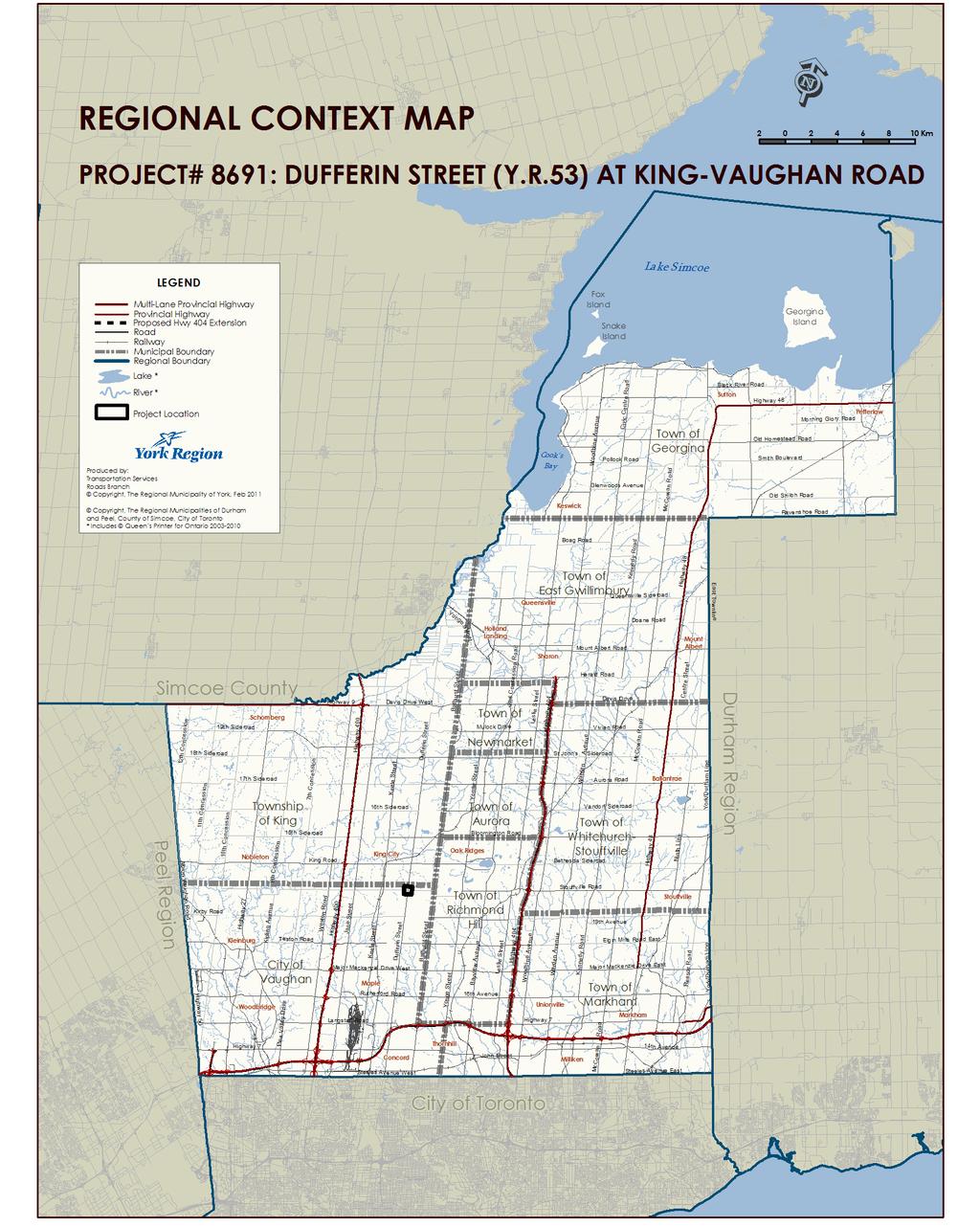
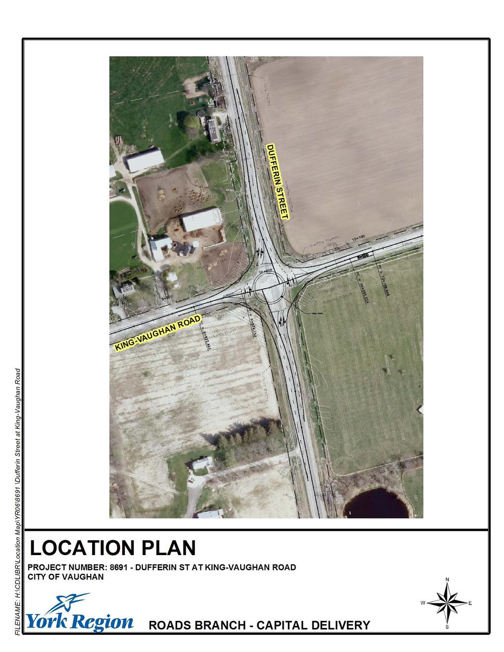
3 A Class Environmental Assessment study was initiated in 2009 to address operational concerns at the intersection of Dufferin Street and King Vaughan Road The intersection of Dufferin Street and King Vaughan Road is located in the Township of King (see Attachment 1). Dufferin Street and King Vaughan Road are two-lane roads with right turn lanes in both directions on Dufferin Street. The intersection of Dufferin Street and King Vaughan Road has stop sign control on King Vaughan Road. The intersection has had an increase in vehicular traffic in recent years. The current Average Annual Daily Traffic on Dufferin Street is 9,500 vehicles/day and 3,000 vehicles/day on King Vaughan Road. The projected traffic volumes in 2021 on Dufferin Street are 15,000 vehicles per day and 5,000 on King Vaughan Road. The increased traffic volumes have caused operational problems for turning vehicles. As a result, staff initiated a Class Environmental Assessment (EA) study to review the existing conditions and determine the improvements needed to address the problems. Four alternative solutions including dedicated left turn lanes, traffic signals and a roundabout have been considered and analyzed during the Class EA study In order to improve operations at an intersection, it is typical to introduce turn lanes and install traffic signals. Since 2008, the Region has also been considering a roundabout as another alternative to improve operations at an intersection. For this intersection, the following alternative solutions were evaluated as part of the Class EA Study: Signalization in combination with widening to accommodate left turn lanes on Dufferin Street. Signalization in combination with widening to accommodate left turn lanes on both Dufferin Street and King Vaughan Road (symmetrical widening). Signalization in combination with widening to accommodate left turn lanes on both Dufferin Street and King-Vaughan Road (minor Dufferin Street re-alignment to the east). Roundabout intersection in combination with widening to accommodate two lane approaches on Dufferin Street (symmetrical widening). A roundabout is identified as the technically preferred solution The four alternatives were evaluated using a set of comprehensive criteria. The criteria set were comprised of elements such as transportation service, Regional planning initiatives, natural environment, social environment and cost effectiveness.
4 The evaluation of the alternative design solutions concluded the roundabout is the technically preferred alternative (see Attachment 2). A public information centre was held in July 2010 to present the alternative solutions to local residents and interested stakeholders As part of the Class EA process, a public information centre in an open-house format was held on July 13, The public consultation centre was held in conjunction with the public consultation centres for the Class EA studies for the intersections of Jane Street and King Vaughan Road; and Keele Street and King Vaughan Road. This was done to facilitate attendance, due to the proximity of the intersections and to the somewhat commonality of interested residents, business owners and stakeholders. Details of the recommended improvements were shown on display boards. Regional Staff are now finalizing the Environmental Study Report for this project An Environmental Study Report summarizing the Region s plans for addressing the longterm needs at this location through the construction of a roundabout is now being finalized and Regional staff plan to issue the required Notice of Completion. Following Class EA approval, Regional staff will undertake detailed design, property acquisition and utility relocations to the currently programmed construction in To reduce delay and address current operational problems immediately, temporary traffic signals will be installed in 2011 as an interim measure Recognizing the immediate need to alleviate some of the operational problems, the Region is planning to install temporary traffic signals at the intersections of King Vaughan Road and Dufferin Street, King Vaughan Road and Keele Street and King Vaughan Road and Jane Street in the summer of ANALYSIS AND OPTIONS The feasibility of a roundabout at this location was studied to determine if it could be considered as an alternative solution Prior to including a roundabout as an alternative solution, an initial screening was conducted to provide an assessment of the feasibility of a modern roundabout at this location. The screening tool looked at factors such as proximity of other intersections, the grades at the intersection, collision history, number of entry lane requirements and level of service.
5 A roundabout is a possible solution at the intersection of Dufferin Street and King Vaughan Road because they are both two-lane rural roads with low numbers of pedestrians and cyclists A comprehensive evaluation of the alternative solutions was undertaken to determine the advantages and disadvantages of each solution. The evaluation criteria included how each alternative performed based on their impact to traffic operations, public transit, pedestrians and cyclists, traffic safety, Regional planning initiatives, natural environment, social environment and cost. The following are the most significant benefits provided by the roundabout alternative at Dufferin Street and King Vaughan Road when compared to the remainder of the alternatives: Higher level of traffic service than any of the other alternatives. Increased beneficial impacts on safety as all vehicles are required to slow down to navigate the roundabout. Broadside (T-bone) crashes which can occur at signalized intersections tend to be replaced by less severe side-swipe type crashes. Fewer critical profile adjustments for the intersection due to reduced approach speed. Fewer impacts to the natural and social environment. Lower implementation and life-cycle costs. The proposed roundabout will require less property and will cause less impact to existing driveways than the signalized intersection alternatives All intersection alternatives considered require exclusive left turn lanes to facilitate left turn traffic movements and in order not to impede through traffic. The operation of roundabout is on the basis of yield control and does not require exclusive left turn lanes to be installed to facilitate left turn movements and therefore the roundabout alternative will require less space than any of the signalized intersection alternatives considered. The roundabout alternative will require 2,400 m 2 of property (affecting five properties) compared to 8,700 m 2 (affecting four properties) required for the comparative signalized intersection alternative. In addition, the roundabout alternative will impact three existing driveway accesses versus seven driveways impacted by the signalized intersection alternatives. The proposed roundabout will require fewer trees to be removed and impact fewer culverts than the signalized intersection alternatives The roundabout alternative will cause less impact to trees than any of the signalized intersection alternatives considered (28 compared to eight trees). In addition, the
6 roundabout alternative will cause less impact to existing culverts than any of the signalized intersection alternatives considered (i.e. three compared to one culvert). The roundabout will cost about $1,075,000 less to construct than a signalized intersection, and its 20-year life-cycle cost will be about $1,385,000 less A comparative life cycle cost analysis was conducted as part of the evaluation process for the alternative solutions. The results were as follows: Cost Table 1 Life Cycle Cost Signalized Intersection Roundabout Intersection Property $1,075,000 $300,000 Implementation 1,700,000 1,400,000 Injury Collision 420, ,000 Maintenance and Operations 160,000 60,000 Total $3,355,000 $1,970,000 The roundabout alternative will be significantly cheaper to implement, maintain and operate, than a signalized intersection. Local public opinion is in favour of a roundabout The preliminary layout of a roundabout at the Dufferin Street and King Vaughan Road intersection was well received by most of the attendees at a Public Consultation Centre held on July 13, The majority of the comments received at the public consultation centre and by correspondence, were in favour of the improvements and emphasised the desire for advanced implementation of the improvements. Pedestrians and cyclists will be accommodated at the proposed roundabout Dedicated bicycle lanes are not provided in a roundabout, as this keeps cyclists to the outside circulatory road where they can be cut off by exiting motorists. Cyclists are typically given the choice of either navigating a roundabout as a pedestrian, by allowing them to dismount before entering the roundabout, or to have them take the lane and navigate the roundabout as a motorist. Pedestrian crossings for roundabouts are located on the approaches to the roundabout, a distance away from the circulatory road. For this reason, pedestrians have a less direct route to their destination and must travel further when walking around a roundabout.
7 The Dufferin and King Vaughan Road roundabout is situated in a rural location and we have observed no pedestrian activity. Therefore, it is recommended that a shared use bicycle/pedestrian path or Bypass be used at this location to reduce the number of crossing points thereby increasing safety. Several challenges will be encountered during the implementation of the Dufferin Street and King Vaughan Road roundabout if approved Roundabouts are still an emerging concept in Ontario and the vast majority of road users are accustomed to standard signalized intersection operations. If approved, the Dufferin Street and King Vaughan Road roundabout would be the first roundabout to be implemented within York Region s network of arterial roads. This could bring the following challenges which will need to be addressed prior to moving forward: Regional road users will require education and awareness on roundabout operations prior to and after implementation of the roundabout. Summer and winter maintenance requirements for roundabouts will have to be planned. Monitoring of driver behaviour will be required initially through regular police presence. Need to develop a process/policy to follow in the selection of roundabouts on Regional roads. A public education campaign via media will be required because motorists in the GTA are not familiar with roundabout operations Given the limited number of roundabouts in operation in Ontario, this is an operating condition most motorists are unfamiliar with. Very little motorist education has been dedicated to familiarizing motorists with the rules for using a roundabout on an Ontariowide basis. Each municipality that has introduced roundabouts has undertaken an extensive public education campaign in their community. This is starting to change as The Ministry of Transportation has introduced general information on the use of roundabouts in their 2008 Driver Training Handbook. Given the impact to arterial road operations, Regional municipalities such as Waterloo, Durham and Ottawa have undertaken comprehensive education and information programs prior to opening roundabouts. These programs have typically included media campaigns that include radio advertisements, newspaper advertisements, media releases, on-site signs and delivery of brochures to households. A website with detailed information including animation and video was a key component of the campaign and all marketing material referred to the website.
8 On the implementation of a roundabout at the intersection of Dufferin Street and King Vaughan Road, a similar extensive median campaign will be required to inform the residents and businesses within York Region. 5. FINANCIAL IMPLICATIONS The estimated property and construction cost for this project is $2,000,000. These costs do not include costs for the public education campaign. The improvements to the intersection of Dufferin Street and King Vaughan Road have been identified in the Region s Year Roads Construction Program for construction in the year The project will be funded at 10% from Tax Levy and 90% from Development Charges. 6. LOCAL MUNICIPAL IMPACT Staff from the Engineering Departments of the City of Vaughan and the Township of King have been involved during the environmental assessment process and are part of the Technical Advisory Committee established for this project. Staff from the affected local municipalities are aware of the results of the evaluation undertaken and the project team s proposed preferred solution of installing a roundabout at the intersection of Dufferin Street and King Vaughan Road. The implementation of a roundabout will improve traffic safety and operations for the travelling public on this key arterial in the Region s arterial network. It will also ensure that the rural character of the community is maintained and enhanced through the provision of roundabout. Region staff will continue to work with staff from the City of Vaughan and the Township of King through the preliminary and detailed design phases. 7. CONCLUSION Roundabouts are emerging as a favourable solution to address the demand for improvements at intersections of two-lane rural roads with low pedestrian and cyclist volumes. After reviewing the operations at the Dufferin Street and King Vaughan Road intersection and evaluating the alternatives, a roundabout was the preferred solution. For more information on this report, please contact Paul Jankowski, General Manager, Roads at Ext
9 The Senior Management Group has reviewed this report. (The two attachments referred to in this clause are attached to this report.)
10 COUNCIL ATTACHMENT 1
11 COUNCIL ATTACHMENT 2
List of Display Boards
 List of Display Boards Welcome Introduction Municipal Class Environmental Assessment (EA) Process Need and Justification for an Interchange Alternatives for Evaluation Vertical and Horizontal Alignments
3 TRAFFIC CONTROL SIGNAL TIMING AND SYNCHRONIZATION
 Report No. 8 of the Transportation Services Committee Regional Council Meeting of October 20, 2011 3 TRAFFIC CONTROL SIGNAL TIMING AND SYNCHRONIZATION The Transportation Services Committee recommends:
CITY OF SASKATOON COUNCIL POLICY
 ORIGIN/AUTHORITY Clause 1, Report No. 1-1980 and Clause 4, Report No. 22-1990 of the Works and Utilities Committee; Clause 6, Report No. 17-2004 of the Planning and Operations Committee; and Clause D5,
WELCOME TO OPEN HOUSE # 1 June 14, 2017
 Langstaff Road Weston Road to Highway 7 Class Environmental Assessment Study WELCOME TO OPEN HOUSE # 1 June 14, 2017 Please sign in and join our mailing list Purpose of Open House #1 & Study Area York
City of Elizabeth City Neighborhood Traffic Calming Policy and Guidelines
 City of Elizabeth City Neighborhood Traffic Calming Policy and Guidelines I. Purpose: The City of Elizabeth City is committed to ensure the overall safety and livability of residential neighborhoods. One
TRAFFIC CALMING GUIDE FOR TORONTO CITY OF TORONTO TRANSPORTATION SERVICES DIVISION
 TRAFFIC CALMING GUIDE FOR TORONTO CITY OF TORONTO TRANSPORTATION SERVICES DIVISION CITY OF TORONTO TRANSPORTATION SERVICES DIVISION 2016 TRAFFIC CALMING GUIDE FOR TORONTO TABLE OF CONTENTS Introduction
5 REQUEST FOR GRADE-SEPARATED PEDESTRIAN UNDERPASS CROSSINGS OF LESLIE STREET AND ST. JOHN S SIDEROAD TOWN OF AURORA
 5 REQUEST FOR GRADE-SEPARATED PEDESTRIAN UNDERPASS CROSSINGS OF LESLIE STREET AND ST. JOHN S SIDEROAD TOWN OF AURORA The Transportation Services Committee recommends the adoption of the recommendations
Tonight is an opportunity to learn about the Study and ask questions of the Study Team members.
 Exhibit 1 Welcome Second Open House Tonight is an opportunity to learn about the Study and ask questions of the Study Team members. A first Public Open House was held on September 18th, 2013 which presented
Document 2 - City of Ottawa Pedestrian Crossover (PXO) Program
 Program") 40 Document 2 - City of Ottawa Pedestrian Crossover (PXO) Program OVERVIEW The City of Ottawa Pedestrian Crossover (PXO) Program provides the basis for PXO implementation in Ottawa. The program s processes
40 Document 2 - City of Ottawa Pedestrian Crossover (PXO) Program OVERVIEW The City of Ottawa Pedestrian Crossover (PXO) Program provides the basis for PXO implementation in Ottawa. The program s processes
3 FRAMEWORK FOR IMPLEMENTATION OF LAKE-TO-LAKE CYCLING ROUTE
 3 FRAMEWORK FOR IMPLEMENTATION OF LAKE-TO-LAKE CYCLING ROUTE The Planning and Economic Development Committee recommends the adoption of the recommendations contained in the following report dated December
APPENDIX 2 LAKESHORE ROAD TRANSPORTATION REVIEW STUDY EXECUTIVE SUMMARY
 APPENDIX 2 LAKESHORE ROAD TRANSPORTATION REVIEW STUDY EXECUTIVE SUMMARY Appendix 2 City of Mississauga Lakeshore Road FINAL REPORT Transportation Review Study December 2010 EXECUTIVE SUMMARY Study Purpose
AGENDA REPORT. Issue: Discussion of potential improvements on Barnwell Road at Niblick Drive
 AGENDA REPORT To: From: By: Honorable Mayor and City Council Members Warren Hutmacher, City Manager Tom Black, Public Works Director Date: March 23, 2016 Agenda: March 28, 2016 WORK SESSION AGENDA: Barnwell
TRAFFIC SIGNALS OR ROUNDABOUT AT THIS UNUSUAL INTERSECTION?
 TRAFFIC SIGNALS OR ROUNDABOUT AT THIS UNUSUAL INTERSECTION? Presenting Author Phil Weber, P.Eng. GHD Inc. (The Home of Ourston Engineering) 11 Allstate Parkway, Suite 310 Markham, ON L3R 9T8 Phone (905)
4 COMMUNITY SAFETY ZONES WALTER SCOTT PUBLIC SCHOOL AND ROSELAWN PUBLIC SCHOOL TOWN OF RICHMOND HILL
 4 COMMUNITY SAFETY ZONES WALTER SCOTT PUBLIC SCHOOL AND ROSELAWN PUBLIC SCHOOL TOWN OF RICHMOND HILL The Transportation Services Committee recommends the adoption of the recommendations contained in the
CITY CLERK. (City Council on October 2, 3 and 4, 2001, adopted this Clause, without amendment.)
") CITY CLERK Clause embodied in Report No. 7 of the, as adopted by the Council of the City of Toronto at its meeting held on October 2, 3 and 4, 2001. 15 Draft By-laws- Installation of Speed Humps - Various
CITY CLERK Clause embodied in Report No. 7 of the, as adopted by the Council of the City of Toronto at its meeting held on October 2, 3 and 4, 2001. 15 Draft By-laws- Installation of Speed Humps - Various
4 DISRUPTION MANAGEMENT PLAN HIGHWAY 7 RAPIDWAY CONSTRUCTION BETWEEN BAYVIEW AVENUE AND WARDEN AVENUE TOWNS OF MARKHAM AND RICHMOND HILL
 4 DISRUPTION MANAGEMENT PLAN HIGHWAY 7 RAPIDWAY CONSTRUCTION BETWEEN BAYVIEW AVENUE AND WARDEN AVENUE TOWNS OF MARKHAM AND RICHMOND HILL The Transportation Services Committee recommends the adoption of
Pedestrian Crossing Guidelines 2016
 Pedestrian Crossing Guidelines 2016 Engineering Services 1.0 Introduction and Background The City of Kingston s first Pedestrian Crossing Guidelines were approved by Council in 2008 in order to provide
Zlatko Krstulich, P.Eng. City of O9awa
 Zlatko Krstulich, P.Eng. City of O9awa 1. Introduction to the Ontario Traffic Manual Series 2. What is OTM Book 18: Bicycle Facilities? 3. Study / Committee Team Members 4. Brief overview of the content
Co-ordinator Transportation Committee. Director, Mobility Services and Corporate Fleet Services Environment and Transportation Department
 28 REGIONAL MUNICIPALITY OF OTTAWA-CARLETON MUNICIPALITÉ RÉGIONALE D OTTAWA-CARLETON REPORT RAPPORT Our File/N/Réf. Your File/V/Réf. 25 23-97-R016 DATE 15 April 1997 TO/DEST. FROM/EXP. SUBJECT/OBJET Co-ordinator
Public Information Centre
 WELCOME Public Information Centre Father Tobin Road Lougheed Middle School - Library Wednesday November 7, 2012 7:00 p.m.to 9:00 p.m. Please sign in Neighbourhood Traffic Calming Guide Background The City
2. NORTEL CARLING CAMPUS EXPANSION - PROPOSED MODIFICATIONS TO MOODIE DRIVE (REGIONAL ROAD 59) AND HIGHWAY 417 INTERCHANGE
 AND HIGHWAY 417 INTERCHANGE") 2. NORTEL CARLING CAMPUS EXPANSION - PROPOSED MODIFICATIONS TO MOODIE DRIVE (REGIONAL ROAD 59) AND HIGHWAY 417 INTERCHANGE COMMITTEE RECOMMENDATIONS AS AMENDED That Council approve: 1. The endorsement
2. NORTEL CARLING CAMPUS EXPANSION - PROPOSED MODIFICATIONS TO MOODIE DRIVE (REGIONAL ROAD 59) AND HIGHWAY 417 INTERCHANGE COMMITTEE RECOMMENDATIONS AS AMENDED That Council approve: 1. The endorsement
Transportation Master Plan Advisory Task Force
 Transportation Master Plan Advisory Task Force Network Alternatives & Phasing Strategy February 2016 BACKGROUND Table of Contents BACKGROUND Purpose & Introduction 2 Linking the TMP to Key Council Approved
EXECUTIVE SUMMARY OF CALEDON TRANSPORTATION NEEDS STUDY
 EXECUTIVE SUMMARY OF CALEDON TRANSPORTATION NEEDS STUDY The Caledon Transportation Needs Study has been undertaken as a joint project by the Town of Caledon and the Region of Peel to determine the existing
REPORT CONCURRENCE. City Manager. The General Manager concurs with the recommendation of this report.
 COUNCIL REPORT Report No. ENG 08-018 Executive Committee Date: May 0, 018 File No: 5400-1 To: From: Subject: Mayor and Council Purvez Irani, Senior Transportation Engineer Bluejay Street Road Improvements
CITY OF VAUGHAN EXTRACT FROM COUNCIL MEETING MINUTES OF OCTOBER 30, 2012
 CITY OF VAUGHAN EXTRACT FROM COUNCIL MEETING MINUTES OF OCTOBER 30, 2012 Item 31, Report No. 39, of the Committee of the Whole, which was adopted without amendment by the Council of the City of Vaughan
ROUNDABOUTS. Improving Safety and Efficiency. SR83 & Smithville Western Rd. Joel Montgomery, PE Director of Administration
 ROUNDABOUTS Improving Safety and Efficiency SR83 & Smithville Western Rd. Joel Montgomery, PE Director of Administration The Ohio Department of Transportation District 3 906 North Clark Ave. Ashland, OH
Item No. 14 Town of Atherton
 Item No. 14 Town of Atherton CITY COUNCIL STAFF REPORT CONSENT AGENDA TO: THROUGH: FROM: HONORABLE MAYOR AND CITY COUNCIL GEORGE RODERICKS, CITY MANAGER MICHAEL KASHIWAGI, COMMUNITY SERVICES DIRECTOR MARTY
CITY OF OTTAWA ROADWAY MODIFICATION APPROVAL UNDER DELEGATED AUTHORITY
 RMA-2015-ATM-038 CITY OF OTTAWA ROADWAY MODIFICATION APPROVAL UNDER DELEGATED AUTHORITY DATE: April 22, 2015 SUBJECT Approval of Roadway Modifications Recommended through an Area Traffic Management Study
CITY OF HAMILTON PLANNING AND ECONOMIC DEVELOPMENT DEPARTMENT Transportation Planning and Parking Division
 CITY OF HAMILTON PLANNING AND ECONOMIC DEVELOPMENT DEPARTMENT Transportation Planning and Parking Division TO: Chair and Members Public Works Committee COMMITTEE DATE: June 18, 2018 SUBJECT/REPORT NO:
POLICY: TRAFFIC CALMING
 2006 MAY REFERENCE: COUNCIL APPROVED BY COUNCIL MAY 23, 2006 CITY OPERATIONS - NO. 608 POLICY: TRAFFIC CALMING A. All requests for traffic calming within the City shall be considered in accordance with
1 VicRoads Access Management Policies May 2006 Ver VicRoads Access Management Policies May 2006 Version 1.02
 1 VicRoads Access Management Policies May 2006 Ver 1.02 VicRoads Access Management Policies May 2006 Version 1.02 2 VicRoads Access Management Policies May 2006 Ver 1.02 FOREWORD FOR ACCESS MANAGEMENT
We support the following: Tom Davies Square 200 Brady Street Sudbury, Ontario
 April 4, 2014 Tom Davies Square 200 Brady Street Sudbury, Ontario RE: Second Avenue Reconstruction Project and Panel Consultation Dear City of Greater Sudbury Mayor and Council: The (SMAP), a council appointment
180 Grand Avenue, Suite x117 Dowling Associates, Inc.
 180 Grand Avenue, Suite 250 510.839.1742 x117 Oakland, CA 94612 510.839.0871 fax www.dowlinginc.com mbowman@dowlinginc.com Dowling Associates, Inc. Date: Memorandum To: CC: From: Ms. Leah Greenblat City
Public Information Meeting. Orange Camp Road. Dr. Martin Luther King Jr. Beltway to I-4. Presented by: Volusia County August 2, 2018
 Public Information Meeting Orange Camp Road Dr. Martin Luther King Jr. Beltway to I-4 Presented by: Volusia County August 2, 2018 1 Project Goals To improve the operations and safety for Orange Camp Road
102 Avenue Corridor Review
 February 26, 2015 102 Avenue Corridor Review Transportation Association of Canada Road Safety Engineering Award Submission for the City of Edmonton Introduction Transportation Association of Canada Road
Way. Roundabout (FUNCTIONING AS A ROUNDABOUT) Driving the
 Driving the") (FUNCTIONING AS A ROUNDABOUT) Roundabouts are becoming more common across the U.S. as a way to improve traffic flow and reduce serious accidents. But for drivers who have never used a roundabout, it can
(FUNCTIONING AS A ROUNDABOUT) Roundabouts are becoming more common across the U.S. as a way to improve traffic flow and reduce serious accidents. But for drivers who have never used a roundabout, it can
a) receiving of legal advice subject to solicitor client privilege and labour relations regarding contract negotiations
 receiving of legal advice subject to solicitor client privilege and labour relations regarding contract negotiations") Regional Municipality of Waterloo Planning and Works Committee Agenda Tuesday, April 4, 2017 9:30 a.m. (Following Closed Session) Regional Council Chamber 150 Frederick Street, Kitchener Media Release:
Regional Municipality of Waterloo Planning and Works Committee Agenda Tuesday, April 4, 2017 9:30 a.m. (Following Closed Session) Regional Council Chamber 150 Frederick Street, Kitchener Media Release:
Chapter 3 DESIGN SPECIFICATIONS
 Brampton PathWays Planning and Design Guidelines 27 Chapter 3 DESIGN SPECIFICATIONS 3.1 CLASS 1 MULTI-USE PATH Off-road multi-use trails are the backbone of the Brampton PathWays Network. They are typically
City of Prince Albert Statement of POLICY and PROCEDURE. Department: Public Works Policy No. 66. Section: Transportation Issued: July 14, 2014
 Page: 1 of 8 1 POLICY 1.01 The City shall follow all of the specifications in the Manual of Uniform Traffic Control Devices for Canada, prepared by the National Committee of Uniform Traffic Control, and
2. Executing a legal agreement with respect to (1) above.
 above.") 3. INSTALLATION OF TRAFFIC CONTROL SIGNALS AT HUNT CLUB AND PAUL ANKA TO ACCOMMODATE THE DEVELOPMENT OF A GAS BAR, CONVENIENCE STORE AND CAR WASH COMMITTEE RECOMMENDATIONS That Council approve the installation
3. INSTALLATION OF TRAFFIC CONTROL SIGNALS AT HUNT CLUB AND PAUL ANKA TO ACCOMMODATE THE DEVELOPMENT OF A GAS BAR, CONVENIENCE STORE AND CAR WASH COMMITTEE RECOMMENDATIONS That Council approve the installation
WELCOME Public Information Centre
 WELCOME Public Information Centre Fernforest Drive Brampton Soccer Centre Community Room #2 Tuesday January 19, 2016 6:30 p.m.to 9:00 p.m. Please sign in Neighbourhood Traffic Calming Guide Background
Intersection Improvement: Sturgeon Road, Silver Avenue and Murray Park Road Roundabout. Welcome. Public Information Session
 Intersection Improvement: 1 Welcome WHY IS AN INTERSECTION IMPROVEMENT NEEDED? 2 Traffic volumes for Sturgeon Road, Silver Avenue and Murray Park Road exceed the capacity of the existing 4-way stop controlled
Public Works and Infrastructure Committee. General Manager, Transportation Services
 STAFF REPORT ACTION REQUIRED Extending the Bay Street Bicycle Lanes Date: May 16, 2013 To: From: Public Works and Infrastructure Committee General Manager, Transportation Services Wards: Toronto Centre
Coquitlam Cross-town Bike Route Improving Bicycle Facilities in a Mature Suburban Environment
 Coquitlam Cross-town Bike Route Improving Bicycle Facilities in a Mature Suburban Environment Sarah Rocchi, Vice-President, Projects, Opus International Consultants (Main Presenter) Catherine Mohoruk,
Downey Road. Transportation Improvement Study
 Downey Road Transportation Improvement Study Workshop 2 Participant Handbook Workshop 1 May 18 and 19, 2016 Workshop 2 June 23 and 28, 2016 Prepared By: City of Guelph Paradigm Transportation Solutions
TRAFFIC CALMING POLICY NEWTOWN TOWNSHIP DELAWARE COUNTY, PA
 TRAFFIC CALMING POLICY NEWTOWN TOWNSHIP DELAWARE COUNTY, PA September 2014 1 TABLE OF CONTENTS INTRODUCTION... 3 PURPOSE AND GOALS... 3 DEFINITIONS... 4 APPLICABILITY... 5 ELIGIBLE STREETS... 5 LOCATION
TRAFFIC CALMING TOOLBOX. For the residents of the City of Decatur, Georgia
 TRAFFIC CALMING TOOLBOX For the residents of the City of Decatur, Georgia 2 City of Decatur Traffic Calming Toolbox Public Works Department 2635 Talley Street Decatur, GA 30030 404.377.5571 3 Welcome to
Welcome. If you have any questions or comments on the project, please contact:
 Welcome This drop-in public open house is intended to provide information about the Bay Street bike lanes project. This project proposes a dedicated cycling facility along Bay Street between Aberdeen Avenue
Bank Street Widening Class EA Study Leitrim Road to Rideau Road. Gloucester South Seniors Centre, 4550 Bank Street
 AECOM 302 1150 Morrison Drive 613 820 8282 tel Ottawa, ON, Canada K2H 8S9 613 820 8338 fax www.aecom.com Minutes of Meeting Date of Meeting April 4, 2013 Start Time 6:30 p.m. Project Number 60246226 Project
The Corporation of the City of Sarnia. School Crossing Guard Warrant Policy
 The Corporation of the City of Sarnia School Crossing Guard Warrant Policy Table of Contents Overview And Description... 2 Role of the School Crossing Guard... 2 Definition of a Designated School Crossing...
Welcome to the Open House
 Leslie Street Between 19 th Avenue and Stouffville Road Addendum to Class Environmental Assessment Study Welcome to the Open House Please sign in at the front desk. March 28, 2017 Richmond Green Sports
INTERSECTION IMPROVEMENTS
 MCHENRY COUNTY DIVISION OF TRANSPORTATION SEPTEMBER 2012 RIVER ROAD AT DOWELL ROAD INTERSECTION IMPROVEMENTS INSIDE: Public Meeting #1 Summary 1 Public Meeting #2 Summary 1 Key Issues Raised at Public
2. KING EDWARD AVENUE AND ST. PATRICK STREET - SAFETY IMPROVEMENT
 2. KING EDWARD AVENUE AND ST. PATRICK STREET - SAFETY IMPROVEMENT COMMITTEE RECOMMENDATION That Council approve the construction of the proposed modifications for the intersection of King Edward Avenue
Improving Cyclist Safety at the Dundas Street West and Sterling Road Intersection
 STAFF REPORT ACTION REQUIRED Improving Cyclist Safety at the Dundas Street West and Sterling Road Intersection Date: August 17, 2012 To: From: Wards: Reference Number: Public Works and Infrastructure Committee
Byron Avenue. Public Meeting. Thursday June 16, Traffic Calming Design Sherbourne Road to Island Park Drive
 Byron Avenue Traffic Calming Design Sherbourne Road to Island Park Drive Public Meeting Thursday June 16, 2016 Our Lady of Fatima Parish 153 Woodroffe Avenue 6 9pm 1 Project Summary Area Projects Background
to the Public Information Centre for the Downtown Traffic Study
 to the Public Information Centre for the Downtown Traffic Study City of Sault Ste. Marie July 25, 2018 Purpose of Study Determine if changes to one-way corridors can enhance downtown s character and spaces
Richmond-Adelaide Cycle Tracks
 Public Drop-In Event Richmond-Adelaide Cycle Tracks June 25, 2018 12:00 p.m. 3:00 p.m. 4:30 p.m. 7:30 p.m. Metro Hall, Rotunda 55 John Street 1 Purpose of Event In Scope Communicate an update about the
Appendix C. TRAFFIC CALMING PROGRAM TOOLBOX
 Appendix C. TRAFFIC CALMING PROGRAM TOOLBOX PHASE I...2 Do Not Enter Sign...3 One-Way Sign...4 Turn Prohibition...5 Pavement Markings...6 Speed Monitoring Trailer...7 Neighborhood Speed Watch...8 Police
AIRPORT ROAD ENVIRONMENTAL ASSESSMENT
 WELCOME TO PUBLIC INFORMATION CENTRE #1 AIRPORT ROAD ENVIRONMENTAL ASSESSMENT From Braydon Boulevard/Stonecrest Drive to Countryside Drive November 23, 2017 6:30 PM 8:30 PM Please sign in and fill out
2 BOLTON COMMUTER RAIL SERVICE FEASIBILITY STUDY
 2 BOLTON COMMUTER RAIL SERVICE FEASIBILITY STUDY The Planning and Economic Development Committee recommends the adoption of the recommendations contained in the following report dated April 15, 2011 from
Bicycle Master Plan Goals, Strategies, and Policies
 Bicycle Master Plan Goals, Strategies, and Policies Mobilizing 5 This chapter outlines the overarching goals, action statements, and action items Long Beach will take in order to achieve its vision of
Developing a Safer Cycling Strategy for the ACT ACRS Conference August 2012
 Developing a Safer Cycling Strategy for the ACT ACRS Conference 2012 Peter Strang Canberra Manager Sarah Court Transport Consultant 10 August 2012 Presentation Outline Background Data Analysis (Stage 1)
BETHEL ROAD AND SEDGWICK ROAD CORRIDOR STUDY
 DRAFT PLAN City Council Meeting August 14, 2017 STUDY AREA Sedgwick Corridor State Route 160, principal arterial with Class 3 access management designation, commuter and freight route, connection to SR
INDUSTRIAL BUILDING 3009 HAWTHORNE ROAD CITY OF OTTAWA TRANSPORTATION OVERVIEW REVISED. Prepared for: Canada Inc.
 INDUSTRIAL BUILDING 3009 HAWTHORNE ROAD CITY OF OTTAWA TRANSPORTATION OVERVIEW REVISED Prepared for: 7849648 Canada Inc. Octiober 1, 2015 114-598 Overview_2.doc D. J. Halpenny & Associates Ltd. Consulting
Recommended Roadway Plan Section 2 - Land Development and Roadway Access
 Recommended Roadway Plan Section 2 - Land Development and Roadway Access SECTION 2 Land Development and Roadway Access 2.1 Land Use and Access Management The Federal Highway Administration (FHWA) defines
COUNTY ROAD 22 HORSESHOE VALLEY ROAD. Municipal Class Environmental Assessment. simcoe.ca
 OCTOBER 2014 Municipal Class Environmental Assessment COUNTY ROAD 22 HORSESHOE VALLEY ROAD Project A Truck Climbing Lanes Project B Intersection Improvements simcoe.ca CORPORATE COMMUNICATIONS DEPARTMENT
Saskatchewan Drive Roadway Rehabilitation and Shared-Use Path Widening
 Saskatchewan Drive Roadway Rehabilitation and Shared-Use Path Widening We are here today to present the draft plan for the Saskatchewan Drive Roadway Rehabilitation and Shared-Use Path Widening project
Prepared By: Town of Waxhaw Traffic Calming Policy
 Policy For Resolutions for Town Meetings Prepared By: Town Manager Michael McLaurin Director Greg Mahar CPD Waxhaw N.C. Community Planning &Development Administrative Department Department: Date Approved
Intersection Safety 6/7/2015 INTERSECTIONS. Five basic elements should be considered in intersection design. Intersection Safety (continued)
") Intersection Safety S. M. SOHEL MAHMUD Assistant Professor Accident Research Institute (ARI), Bangladesh University of Engineering and Technology (BUET) Dhaka-1000, Bangladesh 1 Outline of the Presentation
Intersection Safety S. M. SOHEL MAHMUD Assistant Professor Accident Research Institute (ARI), Bangladesh University of Engineering and Technology (BUET) Dhaka-1000, Bangladesh 1 Outline of the Presentation
Having held a public hearing, that Council approve:
 3. MODIFICATIONS TO MERIVALE ROAD FROM FALLOWFIELD ROAD TO OLD HIGHWAY 16 TO ACCOMMODATE THE GROWTH WITHIN THE SOUTH MERIVALE BUSINESS PARK - PUBLIC HEARING COMMITTEE RECOMMENDATIONS Having held a public
Cycle Track Design Best Practices Cycle Track Sections
 Design Best Practices Sections It is along street segments where the separation and protection methods of cycle tracks offer more comfort than conventional bicycle lanes, and are more attractive to a wide
Harbord Street and Hoskin Avenue Bicycle Lane Upgrades
 STAFF REPORT ACTION REQUIRED and Bicycle Lane Upgrades Date: April 22, 2014 To: From: Wards: Reference Number: Public Works and Infrastructure Committee General Manager, Transportation Services 19 and
Classification Criteria
 SCHEDULE D TO RECOMMENDED OFFICIAL PLAN AMENDMENT NO. 40 SCHEDULE C-4 Road Criteria Criteria Traffic Service Objective Land Service/Access Typical Daily Traffic Volume Flow characteristics Travel Speed
I-95/Temple Avenue Improvements Project Colonial Heights, VA
 I-95/Temple Avenue Improvements Project Colonial Heights, VA Pardon Our Dust Informational Meeting February 3, 2016 Harold Dyson, P.E. Construction Manager, Richmond District Tom Heil, P.E. Allan Myers
From Mile Zero to Target Zero the Dawson Creek Case Study
 From Mile Zero to Target Zero the Dawson Creek Case Study Raheem Dilgir, President, TranSafe Consulting Ltd. and Kevin Henderson, Manager of Planning and Development, City of Dawson Creek Paper prepared
Access Management Regulations and Standards
 Access Management Regulations and Standards January 2014 Efficient highway operation Reasonable property access Concept of Access Management The way to manage access to land development while preserving
APPENDIX A: Complete Streets Checklist DRAFT NOVEMBER 2016
 APPENDIX A: Complete Streets Checklist DRAFT NOVEMBER 2016 Complete Streets Checklist MetroPlan Orlando s Complete Streets Checklist is an internal planning tool for staff to further implementation of
COMMITTEE RECOMMENDATIONS. That Council approve:
 4. MODIFICATIONS TO INNES ROAD (REGIONAL ROAD 30) AND TENTH LINE ROAD (REGIONAL ROAD 47) TO ACCOMMODATE THE DEVELOPMENT OF THE TRINITY COMMONS SHOPPING CENTRE COMMITTEE RECOMMENDATIONS That Council approve:
CITY OF SAINT JOHN TRAFFIC CALMING POLICY
 CITY OF SAINT JOHN TRAFFIC CALMING POLICY VERSION: 1.0 April 10, 2012 Pedestrians, Cyclists and Motorists Sharing Street Spaces CONTENTS INTRODUCTION... 3 POLICY GOAL... 3 POLICY OBJECTIVES... 3 GUIDING
Design Public Hearing MassDOT Project # February 19, 2015 Chatham Town Hall Annex 7:00 P.M.
 Design Public Hearing MassDOT Project #606596 February 19, 2015 Chatham Town Hall Annex 7:00 P.M. Overview Process to date Project goals Data collection results Existing conditions Alternative analysis
TRANSPORTATION NEEDS ASSESSMENT
 TRANSPORTATION NEEDS ASSESSMENT A travel demand analysis was carried out to determine the operational issues and the potential benefit that adding traffic capacity would have on the road network. All the
Glebe Neighbourhood Cycling Plan
 Glebe Neighbourhood Cycling Plan Summary of Public Comments received after June 5 th Public Information Session Comment STUDY NETWORK CS9, CS8, E, E0 CS4, E CS4 CS8 E Suggestions for alternate cycling
Intersection Design. Leah Ness, Craig Hardy and Eric Sorensen
 Intersection Design Leah Ness, Craig Hardy and Eric Sorensen OVERVIEW TYPES OF INTERSECTIONS SCOPING COORDINATION INTERSECTION EVALUATION HORIZONTAL AND VERTICAL LAYOUTS DESIGN COORDINATION CONSTRUCTION
Edenbrook Hill Drive Traffic Calming Study
 WELCOME Public Information Centre Edenbrook Hill Drive Traffic Calming Study Fletchers Meadow Secondary School Wednesday January 20, 2016 6:30 p.m.to 9:00 p.m. Please sign in Neighbourhood Traffic Calming
1223 Michael Street, Suite 100, Ottawa, Ontario, K1J 7T2 P: l F: l
 1223 Michael Street, Suite 100, Ottawa, Ontario, K1J 7T2 P: +1 613.738.4160 l F: +1 613.739.7105 l www.parsons.com City of Ottawa 2017 TIA Guidelines Date July 3, 2018 TIA Screening Form Project 116 York
CITY CLERK. Lesmill Road, Leslie Street to Duncan Mill Road Class Environmental Assessment Study (Don Valley East)
") CITY CLERK Clause embodied in Report No. 14 of the, as adopted by the Council of the City of Toronto at its meeting held on November 6, 7 and 8, 2001. 17 Lesmill Road, Leslie Street to Duncan Mill Road
CITY CLERK Clause embodied in Report No. 14 of the, as adopted by the Council of the City of Toronto at its meeting held on November 6, 7 and 8, 2001. 17 Lesmill Road, Leslie Street to Duncan Mill Road
Rebuilding Highway 7 Town Centre Boulevard to Sciberras Road
 Rebuilding Highway 7 Town Centre Boulevard to Sciberras Road Project Status Update Presentation to City of Markham Development Services Committee October 22, 2013 Presentation Outline Background Status
FINAL REPORT Intersection Control Evaluation Planning Study for the Duluth Area
 FINAL REPORT Intersection Control Evaluation Planning Study for the Duluth Area March 2013 E NGINEERS P LANNERS D ESIGNERS Consulting Group, Inc. Intersection Control Evaluation Planning Study for the
Speed Limits in the Hoddle Grid
 Speed Limits in the Hoddle Grid Recent History of speed limits March 2013 Docs # 7738485 1 Introduction Muncipalities have power to Erect speed limit signs BUT Municipalities DO NOT have the power to approve
Rideau Canal Corridor Pedestrian Crossing Study. Queen Elizabeth Dr.: Preston St. to Laurier Ave. & Colonel By Drive: Hog s Back to Daly Ave.
 Rideau Canal Corridor Pedestrian Crossing Study Queen Elizabeth Dr.: Preston St. to Laurier Ave. & Colonel By Drive: Hog s Back to Daly Ave. Background: Canal parkways evolved over past 100 years Today
Intersection Traffic Control Feasibility Study
 Intersection Traffic Control Feasibility Study CSAH 9 at CSAH 60 (185th Avenue) Prepared For: Dakota County Transportation Department Western Service Center 14955 Galaxie Avenue, 3rd Floor Apple Valley,
2.0 LANE WIDTHS GUIDELINE
 2.0 LANE WIDTHS GUIDELINE Road Engineering Design Guidelines Version 2.0.1 May 2018 City of Toronto, Transportation Services City of Toronto Page 0 Background In early 2014, Transportation Services initiated
Appendix O. Assessment of Bicycle Facility Alternatives
 Appendix O Assessment of Bicycle Facility Alternatives FINAL ASSESSMENT OF CROSS-SECTION ELEMENTS Lakeshore Road, from Mississaga Street to Dorval Drive Town of Oakville Submitted to: Town of Oakville
Welcome. The Brooklin Secondary Plan and Transportation Master Plan are collectively referred to as the Brooklin Study.
 Welcome The Town of Whitby is undertaking a study to prepare a Secondary Plan and Transportation Master Plan to guide and manage growth in the Brooklin area. The Brooklin Secondary Plan and Transportation
Southview Blvd & 3 rd Avenue Improvement Project. Public Open House December 4, to 7pm
 Southview Blvd & 3 rd Avenue Improvement Project Public Open House December 4, 2014 5 to 7pm Southview Blvd & 3 rd Avenue Public Information Meeting Agenda Presentation 5:30 to 6:15 pm Purpose of Project
Traffic Calming Policy
 Page 22 of Report TS-1-13 Development and Infrastructure Division Transportation Services Department Approved by: City Council on February 19, 2013 Report Number: TS-1-13 Effective: February 20, 2013 Amended:
Toronto and East York Community Council. Director, Transportation Services, Toronto and East York District
 No Turn on Red Regulations STAFF REPORT ACTION REQUIRED Date: June 1, 2010 To: From: Toronto and East York Community Council Director, Transportation Services, Toronto and East York District Wards: Trinity
Active Transportation Infrastructure Investment A Business Case
 Active Transportation Infrastructure Investment A Business Case In 2016, the Real Estate Foundation awarded the Capital Regional District a $50,000 grant for Shifting Gears: Land Use Change through Active
Durham Region Long Term Transit Strategy
 Durham Region Long Term Transit Strategy An adaptive, safe, reliable, frequent, accessible and desirable transit system that shapes and connects Durham Region and beyond in an economically and environmentally
Pattullo Bridge Replacement Project Community Connections Phase 2 Consultation. Appendix 3: Open House Display Boards
 Replacement Project Community Connections Phase 2 Consultation Appendix 3: Open House Display Boards November 2016 Welcome! Welcome to the Replacement Project Public Open House We Want to Hear from You