Thanington 4 th Arm Slip Road
|
|
|
- Ann Roberts
- 5 years ago
- Views:
Transcription
1 Walking, Cycling & Horse-Riding Assessment & Review Report On behalf of Pentland Properties Project Ref: 39183/2001 Rev: 1 Date: October 2017 Office Address: Calgarth House, Bank Street, Ashford TN23 1DQ T: +44 (0) E: ashford@peterbrett.com


2
3 Contents 1 Introduction Introduction Background Proposed Highway Scheme Study Area Walking, Cycling & Horse-Riding Assessment Review of Walking, Cycling & Horse-Riding Policies and Strategies Collision Data Public Transport Services & Interchange Information Trip Generators Site Visit Consultation with Key Stake Holders Existing Pedestrian, Cycle and Equestrian Facilities within the Local Area Existing Pedestrian, Cyclist and Equestrian Facilities Beyond Scheme Extents and Links to County/Strategic Networks User Opportunities General Opportunities Strategic Opportunities Pedestrian Specific Opportunities Cyclist Specific Opportunities Equestrian Specific Opportunities Preliminary Design Stage Walking, Cycling & Horse Riding Review General Opportunities Strategic Opportunities Pedestrian Specific Opportunities Cyclist Specific Opportunities Preliminary Design Stage Walking, Cycling & Horse Riding Review Additional items identified during the preliminary design Walking, Cycling & Horse-Riding Review Team Statement iii
4 Figures Figure 1: Proposed scheme layout... 1 Figure 2: Study Area - 5km radius... 2 Figure 3: Existing bus stop location... 4 Figure 4: Sustrans cycle map Figure 5: Survey Locations Tables Table 1 Existing bus services... 5 Table 2 Pedestrian and Cycle User Survey Data Appendices Appendix A Appendix B Appendix C Scheme Drawings Relevant Correspondence Supporting Information iv

5 1 Introduction 1.1 Introduction Peter Brett Associates LLP (PBA) have been appointed by Pentland Properties Limited to carry out the Stage 1 (preliminary) design of the proposed 4 th arm slip road at Thanington. The design and delivery of this off slip from the A2 is a planning requirement of the outline planning consent granted for mixed use development known as Thanington Park, Canterbury. The proposed off slip is referred to as the. 1.2 Background The scheme is a highway improvement scheme that will have a permanent impact on the trunk road and local highway networks, therefore the HD 42/17 Walking, Cycling & Horse-Riding Assessment and Review applies. In accordance with HD 42/17, the scale of the scheme has been assessed (by the Lead Assessor) and is considered to qualify as a large scheme for the purposes of this assessment. Therefore, the scheme will be subject to a Walking, Cycling & Horse-Riding Assessment (chapters 2 and 3 of this document) and Review (chapters 4 and 5) of this document) as part of the Stage 1 Preliminary design stage. This will be followed by Walking, Cycling & Horse-Riding Review at the Stage 2 detailed design. 1.3 Proposed Highway Scheme The proposed scheme involves the provision of the new off slip from the Dover bound carriageway of the A2, currently this direction is not served by the existing grade separated interchange at the A2/A28 Wincheap junction. The slip road will connect to Ten Perch Road, which is to be upgraded to provide 2 lanes in either direction and to relocate the existing roundabout at its northern end. The image below shows the proposed scheme. Figure 1: Proposed scheme layout 1

6 1.3.2 The existing junction of Ten Perch Road and the A28 will be amended to align with the slip road and future relief road as part the proposals The proposed forms part of the wider Canterbury City Council and Kent County Council strategic transport plan for this area of Canterbury, and will form part of their proposed Wincheap Relief Road which aims to create a gyratory system within the Wincheap area. 1.4 Study Area The figure below shows the approximate study area for the assessment report. The area covers a 5km radius from the centre of the scheme and encompasses the city centre of Canterbury, the University of Kent and the villages of Chartham, Bridge and Blean. The area also covers the Great Stour river to the north and open countryside to the south. Figure 2: Study Area - 5km radius 2
7 2 Walking, Cycling & Horse-Riding Assessment he findings of the assessment and any potential opportunities for improvement, are summarised below, as set out in Chapter 4 of HD42/ Review of Walking, Cycling & Horse-Riding Policies and Strategies The following documents have been reviewed as part of the Assessment: a. Canterbury City Council Local plan b. Canterbury District Transport Strategy c. Kent County Council Local Transport Plan (LPT3 and Draft LPt4 version) d. Thanington Park Transport Assessment e. DfT Cycling and Walking Investment Strategy The CCC local plan and transport strategy both support schemes to encourage sustainable transport measures (eg Walking /cycling routes) and promote future facilities in Canterbury none are located within the immediate area of the proposed slip road. A number of new routes are proposed from the wider Wincheap and Thanington area. The new 4 th arm slip road features prominently within the strategy, as part of the Wincheap Relief Road scheme. The Park and Ride is to be extended in the future to offset the spaces lost through the construction of the off slip, and to provide additional parking capacity The KCC Local Transport Plan provides support for schemes to unlock development and promote use of Active Transport as part of the Safer and Healthier County policy. There are no specific walking or cycling scheme detailed within the vicinity of the proposed off slip. The 4 th arm slip road and Wincheap relief road form part of the draft policy The transport assessment for the Thanington Park development requires the existing London A2 off slip and junction with the A28 to be reconfigured to provide a site access to the development. The proposals will alter the layout of the signalised A28 junction, and provide a shared use footway cycleway to the development. 2.2 Collision Data Personal injury data has been collected for the A2 between the Harbledown and Bridge junctions, and A28 from Thanington to the Rheims Way roundabout for the 5-year period to 30 June 2016 as provided by Kent County Council. The data shows a total of 54 slight incidents, 6 serious and 1 fatality. 6 of the incidents noted as slight injury involved cyclists, on parts of the network outside of the proposed off slip, generally the cyclists and drivers of vehicles have failed to observe one another resulting in minor collisions One of the serious injury incidents involved a cyclist using the A2 Dover bound on slip, this appears to be an isolated incident and is outside of the scope of the proposed works The fatality is noted to have occurred near the Nackington Road emergency off slip, where a vehicle has overturned. This is beyond the scheme limits and did not involve pedestrians, cyclist or Horse riders. 3

8 2.3 Public Transport Services & Interchange Information The figure below show the location of the bus stops in the immediate vicinity of the scheme, the closest bus stops are located in Wincheap, to the east of the scheme, and in Ten Perch Road at the park and ride facility. Figure 3: Existing bus stop location A summary of the local routes and frequencies (In bus services per hour) for the AM and PM peak is presented in the table overleaf. For ease of reference, the daytime frequency is quoted as the total number of buses between the peaks. 4
9 Table 1 Existing bus services Service No. Route Description Frequency at AM Peak ( ) Frequency at PM Peak ( ) Daytime Frequency 1 1A 1X P2 Ashford - Wye - Chilham - Chartham - Canterbury Ashford - Wye - Chilham - Chartham - Canterbury Ashford - Wye - Chilham - Chartham - Canterbury Chartham - Thanington - Canterbury - Spires Academy Brymore Road - Canterbury City Centre - Wincheap Canterbury High School - Chartham Challock - Old Wives Lees - Canterbury Canterbury Bus Station - Chaucer School Wincheap Park & Ride - Canterbury City Centre The Park and Ride operates off-bus ticketing and services run between the site and Canterbury City centre at a timetabled frequency of 8 minutes, Monday to Friday (no services on a Sunday) between 07:00 and 19: There are no rail facilities in the immediate vicinity of the scheme. The nearest rail station is Canterbury East station, approximately 1.1km to the east of the site access via the A28. Canterbury West rail station is located 1.9km to the north east of the site, and can be accessed either via the a28 or the off road shared use route located on the northern side of the Great Stour (a footway cycleway bridge link is provided between Ten Perch Road and this route). 5
10 2.4 Trip Generators There are number of trip generators within the vicinity of the proposed 4 th arm slip road, that may be attractive to pedestrians and cyclists, including: a. The Morrison s supermarket in Ten Perch Road b. The retail park to the north of Ten Perch Road c. Thanington Recreation Ground d. The retail units in Homersham e. The Wincheap Estate (retail and light industrial units) f. Canterbury City Centre, including Canterbury Cathedral and the Marlow theatre The Thanington Park development, the planning consent which requires the provision of the 4 th arm slip road, is located to the south west of the scheme. The development proposals consist of 750 homes, a business park, a new primary school, sports pitches, community facilities and a new, purpose-built hospice. Access to the site will be via two new junctions from Cockering Road, and by modifying the existing A2 London Bound Off Slip. This development is likely to increase pedestrian and cycle trips, although alternative routes away from the A28 are included with the development proposals. 2.5 Site Visit A number of site visits have been undertaken by Anthony Moore (Lead Assessor), the dates and times of these are listed below: a. 28 February 2017, 15:30 to 16:30. This visit was undertaken during overcast weather conditions, to review the existing junction and facilities in Ten Perch Road and the A28 Wincheap junctions. b. 6 March 2017, 19:00 to 20:00. This visit was undertaken during clear weather conditions, primarily to review the existing Ten Perch Road and A28 junction. No cyclists were observed through the scheme, and a low number of pedestrians were observed walking between the Thanington residential area and the A28 towards Wincheap or the Morrison s supermarket. Currently there is street lighting to both the A28 and Ten Perch Road. c. 17 July 2017, 14:00 to 16:30. This site visit was undertaken to the existing pedestrian and cycle facilities within the vicinity of the scheme (there are no equestrian facilities) and included the A28 Wincheap junctions, the facilities in Ten Perch Road and the shared use route north of the Great Stour river The primary findings of the site visits are listed below: a. Pedestrians using the existing signalised crossing at the A2 London bound of slip/a28 junction, travelling from the Thanington residential area (accessed via the footpath adjacent to the off slip) to and from the City Centre direction, and Morrison s supermarket b. Evidence of pedestrians walking up the embankment behind the A2/A28 overbridge, this is likely to be lorry drivers parking in the existing layby accessing the Morrison s supermarket. c. Use of the shared use route north of the Great Stour, by pedestrians and cyclists. The bridge link to Ten Perch Road was observed to be used by pedestrians and a low number of cyclists. 6

11 d. A large number of passengers using the Park and Ride bus stop facility, those observed were using the car parking facility. A number of those egressing the bus were observed to walk to Morrison s prior to returning to the car park. e. A low number of pedestrians walking along the Boundary between the Retail Park and the Wincheap Industrial Estate. 2.6 Consultation with Key Stake Holders Currently the scheme is at the preliminary design stage and therefore the consultation is currently limited to Highways England, Kent County Council and Canterbury City Council, meeting have been held with these authorities as noted below. a. Meetings with Highways England were held on 24 February 2017 and 6 April 2017, where the principles and layout of the scheme were discussed and agreed. Minutes of these meetings are included in Appendix B b. Meetings with Kent County Council and Canterbury City Council, including the walking and cycling officer, were held on 15 March 2017 and 14 July The scheme principles, layout, and interaction with the wider Wincheap relief road were discussed and agreed. Both KCC and CCC are supportive of the scheme as proposed Wider consultation on the scheme proposals will be undertaken as part of the planning application stage of the scheme. 2.7 Existing Pedestrian, Cycle and Equestrian Facilities within the Local Area The following pedestrian, cyclist and equestrian facilities within the scheme extents have been identified: Pedestrian Facilities Signal controlled pedestrian crossings are incorporated in the existing signalised junctions of the A28/Ten Perch Road, the A28/Homersham and the A28 and the London bound A2 off and on slip roads. The footways on the southern side of the A28 are provided at an average width of 2.4m, whilst the northern footways are approximately 2.0m wide. The footways are predominantly asphalt concrete construction, in good condition apart from the area of vehicle overrun damage at the A28/A2 London bound off slip junction. 7


12 Photograph 1: Damage to footway A2 London bound off slip Footpath link from the A28/A2 London bound off slip road junction to the existing Thanington residential area. Photograph 2: Footpath link to Thanington Footways on the A28 Thanington Road, at a nominal width of 2.3m on both sides. The footways are constructed in sections of flag paving and asphalt concrete, with vehicle crossings to existing properties. Generally, the footways are in good condition, dropped kerbs are provided at junctions but not all have tactile paving Footways are provided on the A28 Wincheap, at a nominal width of 2.0m. Again, these are constructed in section of flag paving and asphalt construction. Dropped kerbs are provided junctions, but tactile paving is not installed at all A footway is provided on the eastern side of Ten Perch Road, at a nominal width of 2.4m. A footpath is provided on the western side of Ten Perch Road, this is located away from the carriageway within the Park and Ride, the nominal width of this footpath is 3.0m. Whilst this appears to be used as a shared use route there is no signage provided to confirm this. Photograph 3: Footpath to the west of Ten Perch Road Informal crossing points, with tactile paving, are provided on the northern and eastern arms of the roundabout at the access to Morrison s and the Park and Ride on Ten Perch Road. The crossing point on the western side is provided with dropped kerbs but no tactile paving. 8

13 2.7.8 A second informal crossing point is provided north of the Morrison s roundabout, linking the path from the store to the Park and Ride Informal crossing points, with tactile paving, are provided to the southern and eastern arms of the roundabout at the northern limit of Ten Perch Road. The crossing to the western arm has dropped kerbs only to the outer kerb lines, whilst tactile paving is provided in the splitter island. A crossing point is also provided on the northern arm, set back inside the retail park access itself A shared use footway cycleway link is provided from Ten Perch Road, to the off-road route north of the Great Stour (the Stour Valley Walk). A pedestrian cyclist bridge is provided over the river, north of the Ten Perch Road roundabout Raised bus border kerbs are provided at the existing bus stop in Ten Perch Road, serving the Park and Ride. Photograph 4: Park and Ride bus stop in Ten Perch Road The existing bus stop on the A28 Wincheap, east of the Ten Perch Road junction (east bound), is provided with raised bus border kerbs and a bus shelter The existing bus stop on the A28 Wincheap, east of the Ten Perch Road junction (west bound), is provided with raised bus border kerbs. 9

 to the north of the Great Stour river via a bridge. There is no signage provided on site to highlight this link.")
14 Cycle Facilities The figure below shows the existing cycle facilities in the vicinity of the site, taken from the Sustrans website Figure 4: Sustrans cycle map The footpath on the western side of Ten Perch Road is not signed as a cycle route, but was observed to be used by cyclists during the visit as it connects to the existing shared use route (the Stour Valley Walk) to the north of the Great Stour river via a bridge. There is no signage provided on site to highlight this link. Access for cyclists from the carriageway is only provided by use of the pedestrian crossing points at the A28/Ten Perch Road signalised junction and the dropped kerbs on the western roundabout arms in Ten Perch Road An on-road cycle route is shown on the Canterbury City Council cycle map linking Ten Perch Road to the Wincheap estate, via The Boundary. Directional cycle signage is provided at the junction of the Boundary and Cotton Road. A cycle bypass lane is provided around the road narrowing traffic calming feature in Cotton Road. Photograph 5: Traffic calming feature with cycle bypass 10

15 National cycle route (NCN18), known as the Stour Valley Walk, is located on the northern side of the Great Stour River. This provides a traffic free route between Chartham and Canterbury. Photograph 6: Stour Valley Way cycle route Equestrian Facilities There are no existing equestrian facilities within the immediate vicinity of the site. Walking and Cycling User Survey Data The table below summarises the walking and cycling user survey data provided by Traffic Survey Partners on 3 May 2017, taken during peak hours (am peak 07:00 to 10:00, and pm peak 16:00 to 19:00) Table 2 Pedestrian and Cycle User Survey Data AM PM Ped 1 Ped 2 Ped 3 Ped 4 Ped 5 Ped 6 Ped 7 Ped 8 Pedestrian Cyclists Pedestrian Cyclists Ped 9 Ped 10 Ped 11 Ped 12 Ped 13 Ped 14 Ped 15 Ped 16 Ped The following is a summary of the main points from the data: a. There is a light cycle usage through both the A28 junction and on Ten Perch Road. b. Pedestrian crossing movements between the Morrison s Supermarket and the Park and Ride site/bus stop. From the survey data, it appears pedestrians are crossing Ten Perch Road at both existing informal crossing points and between the crossings (locations ped 5,6 and 7 on the image below) The existing A28 signalised crossing (at the Ten Perch Road junction) are well used, with the predominant movements east/west along the A28 rather than across it, linking to the City Centre. 11
16 Figure 5: Survey Locations 2.8 Existing Pedestrian, Cyclist and Equestrian Facilities Beyond Scheme Extents and Links to County/Strategic Networks The following pedestrian, cyclist and equestrian facilities outside of the immediate scheme extents have been identified: Pedestrian and Cycle Facilities Existing shared use footway cycleway in Homersham, between the A28 Wincheap and Hollow Lane The shared use route located north of the Great Stour River (the Stour Valley Walk) forms part of National Cycle Route 18 between Canterbury and Tunbridge Wells On road cycle route within the Wincheap Industrial Estate, via Cotton Road National Cycle Route 1, the long-distance route between Dover and the Shetland Islands, meet route 18 near Canterbury West rail station Regional Route 16 between Canterbury City Centre and Dover, and connects to Regional Route 17 to Dover via Hawkinge There are a number of footpaths within the vicinity of the site, as shown in green on the Public Rights of Way map below. 12

17 Figure 6 Public Rights of Way map, from KCC Website Equestrian Facilities The Public Rights of Way map above shows the extent of Public Rights of Ways in the vicinity of the site, bridleways are shown in brown. 13

18 3 User Opportunities The opportunities highlighted below are considered to be relevant to the highway scheme and should be considered by the wider design team throughout the progression of the scheme design in addition to any further opportunities that may arise through the ongoing development of the design phases. 3.2 General Opportunities Assessment opportunity 1: The existing A28/A2 London bound off slip is to be altered to provide a 2way link road as part of site access to the Thanington Park development. The design of the 4 th arm slip road proposals will need to be consistent with the alterations at the A28/A2 London bound off slip amendments Assessment opportunity 2: The proposals for the consented Thanington Park development include future pedestrian and cycle link through the existing underpass below the A2 at Birch Road, to link to the existing Homersham development. 3.3 Strategic Opportunities Assessment opportunity 3: The proposed Dover bound A2 off slip forms part of the wider Wincheap Relief Road scheme within the Canterbury City Council Local plan, the scheme design will need to consider connections to the future Relief Road. 3.4 Pedestrian Specific Opportunities Assessment opportunity 4: The pedestrian linkages of the A28 and Ten Perch Road, including the signalised junction will need to be considered as part of the design Assessment opportunity 5: The pedestrian link to the Stour Valley Way from Ten Perch Road will need to be incorporated in to the design. The future extension of the Park and Ride site will affect the route to the existing pedestrian/cycle bridge over the Great Stour and will also need to be considered. Photograph 7: Existing access to Stour Valley Way link 14

19 3.4.3 Assessment opportunity 6: The existing pedestrian linkages between the Retail Park, Morrison s and the Park and Ride site will need to be considered as part of the design for the proposals Assessment opportunity 7: The use of the verge and embankment between the existing layby on the Dover bound carriageway of the A2 and the overbridge shows evidence of use by pedestrians, the proposals will remove the existing layby and subsequently the need for formalising this pedestrian desire line should be reviewed. Photograph 8: Evidence of pedestrian route to wing wall 3.5 Cyclist Specific Opportunities Assessment opportunity 8: The existing cycle link to the Stour Valley Way from Ten Perch Road will need to be incorporated in to the design. The future extension of the Park and Ride site will affect the route to the existing pedestrian/cycle bridge over the Great Stour and will also need to be considered Assessment opportunity 9: Provision of cycle facilities to the A28 signalised junctions should be considered. 3.6 Equestrian Specific Opportunities No specific equestrian opportunities have been identified within the immediate vicinity of scheme. 15
20 4 Preliminary Design Stage Walking, Cycling & Horse Riding Review This chapter reviews opportunities identified during the assessment stage (as noted in Chapter 3 of this document) and actions taken during the preliminary design stage. 4.2 General Opportunities Assessment opportunity 1: The existing A28/A2 London bound off slip is to be altered to provide a 2way link road as part of site access to the Thanington Park development. The design of the 4 th arm slip road proposals will need to be consistent with the alterations at the A28/A2 London bound off slip amendments Action taken/outcome: This junction is outside of the scope of works for the A2 4 th arm slip road, but is being undertaken by the developer of the Thanington Park development. For reference the detailed design of the of the junction alteration is currently in progress (by Peter Brett Associates LLP). The scheme proposals have been agreed with both Highway Authorities (Kent County Council and Highways England). A copy of the General Arrangement plan for the junction is enclosed in Appendix C, the pedestrian and cycle facilities provided are; a. Shared use footway cycleway on the western side of the proposed link road to the development site, terminating in advance of the junction to allow cyclists to re-join the carriageway. b. Provision of a staggered pedestrian crossing of the Link Road at the A28 junction c. The existing crossing of the A28, with narrow central island, is to be removed. Pedestrians wishing to cross north/south on the A28 can use the signalised crossings at existing A2 London bound slip road junction and the A28/Ten Perch Road junctions Assessment opportunity 2: The proposals for the consented Thanington Park development include future pedestrian and cycle link through the existing underpass below the A2 at Birch Road, to link to the existing Homersham development Action taken/outcome: This connection is outside of the scope of works for the 4 th arm slip road, but is a requirement of the Thanington Park development. A link through the underpass, to connect to the existing footways in Birch Road and the wider shared use facilities in Homersham is to be provided as the development progresses. This will provide an alternative to the city centre route for pedestrians and cyclists, as detailed in the Transport Assessment for Thanington Park. 4.3 Strategic Opportunities Assessment opportunity 3: The proposed 4 th arm slip road forms part of the wider Wincheap Relief Road scheme within the Canterbury City Council Local plan, the scheme design will need to consider connections to the future Relief Road Action taken/outcome: Currently the proposals for the relief road are only at an early stage and therefore the pedestrian and cycle provision as part of the relief road scheme has not been determined. The preliminary design of the 4 th arm slip road includes footways at the enlarged roundabout at the northern end of Ten Perch Road, including the Boundary arm as connections to the future relief scheme. These should be reviewed at the detailed design stage if further information of the relief road proposals is available. 16
21 4.4 Pedestrian Specific Opportunities Assessment opportunity 4: The pedestrian linkages of the A28 and Ten Perch Road, including the signalised junction will need to be considered as part of the design Action taken/outcome: Generally, the existing pedestrian crossing facilities at the A28/Ten Perch Road junction have been retained and incorporated in to the proposals The existing footway on the western side of Ten Perch Road is to be removed as part of the proposals. The original scheme retained this footway but required a signalised crossing to be installed at the end of the off slip, this would result in traffic queuing on the slip, towards he A2, which was not acceptable to Highways England. Therefore, the footway and associated crossing have been removed to allow a free slow slip to be provided. A 3.0m wide shared use footway cycleway is provided on the eastern side of Ten Perch Road at the junction with the A28 and use the eastern footway in Ten Perch Road. This connects directly to the Morrison s store, and to the Retail Park via the crossing points at the proposed roundabout, two of the trip generators that have been identified Assessment opportunity 5: The pedestrian link to the Stour Valley Way from Ten Perch Road will need to be incorporated in to the design. The future extension of the Park and Ride site will affect the route to the existing pedestrian/cycle bridge over the Great Stour and will also need to be considered Action taken/outcome: The existing link from the roundabout at the northern end of Ten Perch Road has been retained, with the footways at the roundabout linking to this via the proposed crossing points. Pedestrians travelling from the west (Thanington area) will need to cross Ten Perch Road at the A28 junction (as noted in above) and use the eastern footway in Ten Perch Road, which is to be widened to a 3.0m shared use route as part of the scheme. This results in a marginal increase in walking distance to avoid the proposed off slip. Suitable guard railing to guide pedestrians and prevent access to the western side of Ten Perch Road may need to be considered as part of the detailed design stage A signal controlled crossing on The Boundary is to be included within the proposals for the wider Wincheap Relief Road scheme, subject to the availability of land, to aid linkage to the Great Stour Way route from Ten Perch Road A shuttle bus service between the Thanington Park development and the city centre is to be provided, as noted in the approved Transport Assessment, therefore pedestrians from the Thanington area can use this rather than requiring access to the Park and Ride service to the city centre The future extension of the park and ride will affect the route of the link; the design of the extension will need to consider this but is outside of the current scope of works Assessment opportunity 6: The existing pedestrian linkages between the Retail Park, Morrison s and the Park and Ride site will need to be considered as part of the design for the proposals Action taken/outcome: From site observations and the pedestrian counts a number of pedestrians cross Ten Perch Road between the Park and Ride bus stop and the Morrison s store access. The proposed design will relocate the bus stop inside the park and ride, the proposed pedestrian crossing point at the norther end of Ten Perch Road will therefore be located on the desire line between the bus stop and the Morrison s store. The internal layout of the Park and Ride will need to include a pedestrian link directly from the bus stop and the crossing point to maximise its use. 17
22 Assessment opportunity 7: The use of the verge and embankment between the existing layby on the Dover bound carriageway of the A2 and the overbridge shows evidence of use by pedestrians, the proposals should review the need for formalising this pedestrian desire line Action taken/outcome: The proposed off slip from the Dover bound A2 will be constructed through the existing lay by, therefore the layby will need to be removed and removes this issue. A review of potential locations for a replacement layby on this section of the A2 has been undertaken, this shows there is no suitable location that meets current standards within land available. 4.5 Cyclist Specific Opportunities Assessment opportunity 8: The existing cycle link to the Stour Valley Way from Ten Perch Road will need to be incorporated in to the design. The future extension of the Park and Ride site will affect the route to the existing pedestrian/cycle bridge over the Great Stour and will also need to be considered Action taken/outcome: The existing link from the roundabout at the northern end of Ten Perch Road has been retained and cyclists can access this link from the carriageway in ten Perch Road. As noted in above the existing footway on the western side of Ten Perch Road is to be removed, whilst this is not signed as a shared use facility cyclists have been observed to use it The footway on the eastern side of Ten Perch Road is to be widened to provide a shared use route, access to this from the signalised junction at the A28 will be provided as part of the scheme. There is insufficient width on the A28 overbridge to provide a shared use footway cycle way towards the A2 London bound off slip junction, therefore the modifications will be limited to the A28/Ten Perch Road junctions The proposals for the Wincheap Relief Road scheme will allow a shared use footway cycleway to be provided on the A28 Wincheap, providing a more direct route to the city centre. As noted above a signalised crossing point is to be provided on The Boundary to connect with the Great Stour Way route The future extension of the park and ride will affect the route of the link; the design of the extension will need to consider this but is outside of the current scope of works Assessment opportunity 9: Provision of cycle facilities to the A28 signalised junctions should be considered Action taken/outcome: No additional cycle facilities on the A28 are to be provided as part of the off-slip scheme, due to the following: a. The existing A28 corridor is constrained by the land available for highway improvements, properties and private land are located up to the rear of the existing footways. b. The proximity of the junctions from one another further restricts the scope for improvements (for example advanced stop lines for cyclists will reduce the queuing capacity available) c. The scope of works is limited the A28/Ten Perch Road junction, provision of cycle facilities at this junction, and not the rest of the A28 junctions, would be inconsistent. 18
23 5 Preliminary Design Stage Walking, Cycling & Horse Riding Review This chapter documents any additional user related opportunities identified during the preliminary design phase and records the actions taken /outcomes 5.2 Additional items identified during the preliminary design Preliminary Design Stage Opportunity 1: Currently, cyclists may use the existing A2 dual carriageway. The Stage 1 road safety audit recommends that signage to lead cyclists on to the slip road, and cross perpendicular to the off slip at the end of the nose, should be provided. This would follow the provision at other slip roads from the A2 (for example the Boughton slip road) Action taken/outcome: There is space within the layout to accommodate the recommendation. The appropriate signage and road markings are to be included in the detailed design of the scheme, as agreed with the Project Sponsor in the Designers Response to the Stage 1 Road Safety Audit Preliminary Design Stage Opportunity 2: The Stage 1 Road Safety Audit recommends that pedestrian guardrailing is provided at the end of the western footway the A28/Ten Perch Road and to the proposed central reservation in Ten Perch Road (to deter pedestrians from crossing where no footway is provided) Action taken/outcome: The guardrailing has been included in the scheme proposals, as per the recommendation and agreed with the Project Sponsor in the Designers Response to the Stage 1 Road Safety Audit. 19
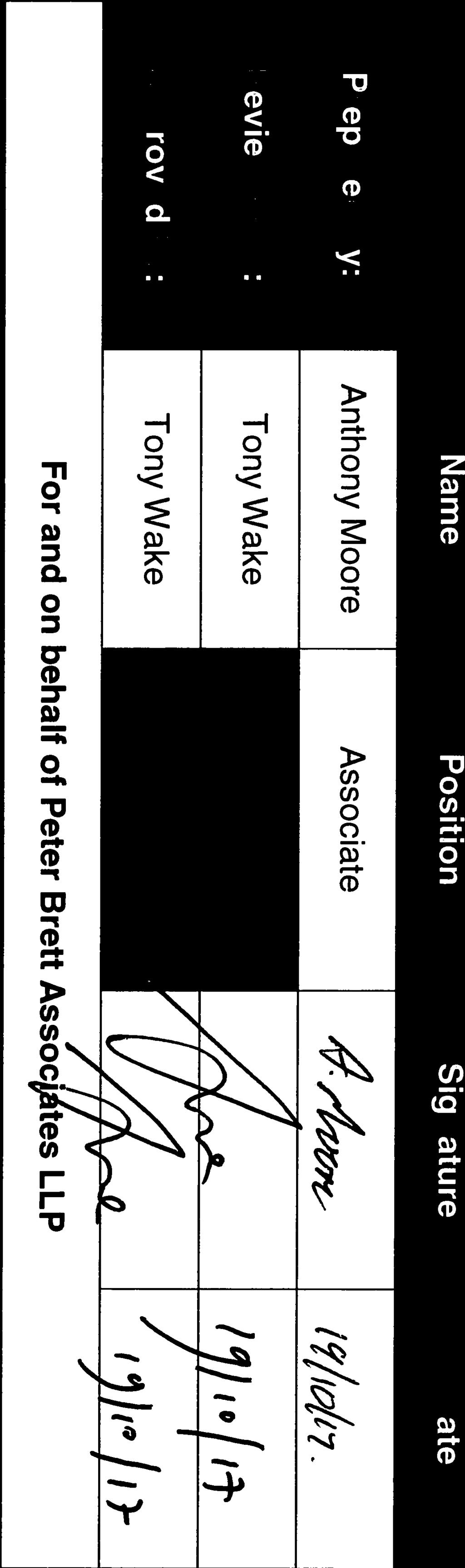
24 6 Walking, Cycling & Horse-Riding Review Team Statement As Lead Assessor, I confirm that this Walking, Cycling & Horse-Riding Review Report has been compiled in accordance with DMRB HD 42/17 and thus records all design team deliberations and decisions relating to Walking, Cycling & Horse-Riding issues and opportunities The Walking, Cycling & Horse-Riding Review was undertaken by the following team: Walking, Cycling & Horse-Riding Lead Assessor Anthony Moore, TMICE Associate Peter Brett Associates LLP Signed: Date: As design team leader I confirm that the assessment has been undertaken at the appropriate stage of scheme development and that the wider design team has been involved in the process I confirm that in my professional opinion the appointed Lead Assessor has the appropriate experience for the role making reference to the expected competencies contained in HD 42/17. Design team leader Tony Wake, Partner Peter Brett Associates LLP Signed: Date: 20
25 Appendix A Scheme Drawings
26
27 Reproduced from/based upon Ordnance Survey material with the permission of Ordnance Survey on behalf of The Controller of Her Majesty's Stationery Office. Crown Copyright. Unauthorised reproduction infringes Crown Copyright and may lead to prosecution or civil proceedings. Licence No Year of Publication 2017 Owner/Purchaser of Mapping PETER BRETT ASSOCIATES LLP user name: anthony moore Z IB Soffit FE FE FE FE CE13.32 CE13.17 CB13.36 CE13.78 CE13.56 CB13.64 IC Gate KLB IB CB14.15 CB13.87 KLB IB IB KLB IB KLB A2 TRUNK ROAD IB 60 CE IC PA CB14.04 KLB 30 CB14.35 KLB CE14.58 CE PA CB14.48 CB CB CB14.88 CB CB IC CB DIA 512 (bend) BoB CB13.74 CB BoB BoB BoB BoB CB13.05 CB MH BoB BoB RS CB12.78 CB13.22 CB12.74 CB13.23 IC HR CB12.25 CB12.29 CB12.51 CB12.71 CB12.51 CB12.38 IC HR CB12.64 HR Soffit HR Soffit Soffit Soffit Soffit Soffit HR A28 THANINGTON ROAD Z Soffit Soffit Soffit Soffit Soffit HR HR RS CB12.45 DIA 515 HR HR EXISTING WING WALL TO A28 OVER BRIDGE CB12.58 CB12.51 A2 TRUNK ROAD RS CB CB DIA 515 CB CB (30mph) DIA CB TEN PERCH ROAD (ILLUSTRATIVE LAYOUT) (30mph) (bend) DIA 670 DIA 512 RETAIL PARK PETROL STATION MORRISONS SUPERMARKET WINCHEAP PARK & RIDE GENERAL NOTES: 1. THIS DRAWING SHALL BE READ IN CONJUNCTION WITH ALL OTHER RELEVANT DOCUMENTATION. 2. DO NOT SCALE FROM THIS DRAWING. 3. ALL DIMENSIONS ARE IN METRES UNLESS SPECIFIED OTHERWISE. 4. DRAWING BASED ON WSP DRAWING 5269-SK02, A2 TOPOGRAPHICAL SURVEY BY MEC AND ORDNANCE SURVEY INFORMATION. LEGEND: PLANNING BOUNDARY PROPOSED CARRIAGEWAY - ASPHALT CONCRETE CONSTRUCTION TIE IN TO EXISTING CARRIAGEWAY PROPOSED FOOTWAY AND TRAFFIC ISLAND - ASPHALT CONCRETE CONSTRUCTION PROPOSED VERGE PROPOSED EARTHWORKS EMBANKMENT (1:3) EXISTING GROUND TO BE RE-PROFILED PROPOSED CARRIAGEWAY HIGH FRICTION SURFACING PROPOSED OVER RUN AREA PROPOSED TACTILE PAVING AT CONTROLLED CROSSING PROPOSED TACTILE PAVING AT UNCONTROLLED CROSSING PROPOSED VEHICLE RESTRAINT SYSTEM (CRASH BARRIER) PROPOSED PEDESTRIAN GUARD RAILINGS PROPOSED LIGHTING COLUMN (INDICATIVE LOCATION) PROPOSED RED UNIDIRECTIONAL RETROREFLECTING ROAD STUD PROPOSED AMBER/RED UNIDIRECTIONAL RETROREFLECTING ROAD STUD PROPOSED GREEN UNIDIRECTIONAL RETROREFLECTING ROAD STUD KLB PROPOSED SOLAR POWERED ILLUMINATED KEEP LEFT BOLLARD TO BE SOLABOLL DUAL ASPECT LED SOLAR POWERED BOLLARD BY PUDSEY DIAMOND WITH WITH KEEP LEFT ARROW (AS DIA 610) IB PROPOSED SOLAR POWERED ILLUMINATED BOLLARD TO BE SOLABOLL DUAL ASPECT LED SOLAR POWERED PLAIN FACED BOLLARD BY PUDSEY DIAMOND SCALE BAR: 1:500 METRIC 10m 0 50m F LAYOUT REVISED AP AM E RETAIL ACCESSES REVISED, LIGHTING UPDATED AP AM D RETAIL ACCESSES REVISED AM TW C ROUNDABOUT AND P&R LAYOUTS ADJUSTED AP AM B LAYOUT UPDATED TO SUIT COMMENTS FROM RSA WSW AM A ROAD MARKINGS LAYOUT REVISED WSW AM Mark Revision Date Drawn Chkd Appd SCALING NOTE: Do not scale from this drawing. If in doubt, ask. UTILITIES NOTE: The position of any existing public or private sewers, utility services, plant or apparatus shown on this drawing is believed to be correct, but no warranty to this is expressed or implied. Other such plant or apparatus may also be present but not shown. The Contractor is therefore advised to undertake their own investigation where the presence of any existing sewers, services, plant or apparatus may affect their operations. Drawing Issue Status APPROVAL THANINGTON FOURTH ARM SLIP ROAD GENERAL ARRANGEMENT PLAN Client PENTLAND PROPERTIES Ltd Date of 1st Issue A0 Scale 1:500 Drawing Number Designed Drawn PG AP Checked AM Approved Revision 39183/2001/001 F Offices throughout the UK and Europe Peter Brett Associates LLP ASHFORD Tel: File Location: j:\ th - thanington fourth arm slip\3-autocad\drawings\2001\39183_2001_001.dwg
28 Appendix B Relevant Correspondence Minutes of meetings with Highways England, dated 24/2/17 and 6/4/17 Minutes of meeting with Kent County Council and Canterbury City Council dated 14/7/17
29
30 C Thanington Park, Canterbury Note of Meeting held at Highways England, Guildford on Thursday 6 th April 2017 Present Kevin Brown KB Highways England Rachel Fisher RF Highways England David Bowie DB Highways England Anthony Moore AM Peter Brett Associates N Borrell NB Pentland Homes Points Arising 1. Planning Condition 10 : NB stated that Planning Condition 10, is, in effect, a Grampian condition, that requires the approval of the detail design for the 4 th Arm, Eastbound Slip Road, prior to works commencing on the Thanington site. He did not believe that it was the intention to prevent development, rather to enable the delivery of the slip road itself. There are also 2 requirements in the Section 106 agreement. 1. Saying that prior to occupation of 300 houses, an agreement is required for the road, and pay the Council the costs of the works, minus Grant Funding 2. Saying that no more than 449 units can be occupied before the road is Practically Complete. KB advised that the scheme is K.C.C. requirement. H.E. are neutral on the project and can see the advantage provided that there is not queueing on the main carriageway / A2. NB asked that H.E. consider that Stage 1 Road Safety Audit Approval be a satisfactory stage at which H.E. could advise Canterbury City Council that the planning Condition 10 could be discharged. The programme for the road requires an agreement by the occupation of the 300 unit, and construction by 450 unit. Pentland propose to commence works on their development in February It will take 6 months to construct the Infrastructure and then say 100 occupations per year. Start: February 2018 Infrastructure: August Occupation: August Occupation: February 2023 The important date here is August 2021 for 299 Occupations. The construction of the slip road will commence around this date. Any detail approvals provided prior to February 2018, to enable a start on the development site, will then be out of date, particularly the Safety Audit, and approvals will have to be applied for and granted again. 1
31 C th Arm Slip Road Design : The conversation moved onto the proposed design of the slip road by PBA. This differs from the WSP scheme in that traffic lights have been removed, to provide a free flow land from the A2. Various points were discussed KB advised that H.E. were more concerned about the Westbound Slip being amended. They noted that an additional set of lights are to be added, and that all the lights should be coordinated to improve the traffic flows. AM & NB advised that PBA are the design engineers for both slip roads and are able to coordinate the design of the signals so that work in conjunction with each other. They advised that the signal designs are being rationalised, and that whilst one set has been added at the site access, another pedestrian crossing had been removed from the A2 with the consent of K.C.C. There were discussions about the interface of the slip road and A28 lanes merging and crossing requirements, visibility requirements etc. 3. Conclusion : KB suggested a Section 73 application to amend the Planning Condition. Nb advised that Pentland would not wish to pursue that route. DB agreed that a Section 73 is not the best solution. DB suggested that we arrange for a Stage 1 Safety Audit now. This would identify any issues with PBA proposed Free Flow design and further advise both sides whether a Stage 1 Safety Audit could be used as a satisfactory design to recommend discharge of the Planning Condition. Action: PBA to submit an Audit Brief for H.E. approval. Action AM Action: PBA to submit C.V. of Audit company who must be suitable for work on High Speed Network. Action AM Action: Accident Stick Plots need to be provided. Action AM Action: H.E. need contact at K.C.C. to liaise on Road Safety Audit. Action NB 2

32 C Thanington Park, Canterbury New A2 Slip Road Application Note of Meeting held at PBA s offices in Ashford 1
33 C on Friday 14 th July 2017 Present Ruth Goudie Colin Finch Andy Moreton N Borrell I Bull G Heard A Moore (AM) R Sellwood (RS) Canterbury City Council Kent CC Kent CC Pentland Pentland PBA PBA Sellwood Planning Points Arising 1. RS explained the background to the submission of the new A2 slip road planning application and how the aim is to submit it in October There is urgency due to the deadline to draw down Growth Fund monies. RG / CF / A Moreton agreed to check what is the trigger to release funds (technical start / completion / planning permission?). The aim is to have monthly joint CCC / KCC / Pentland meetings to agree the content of the application. 2. RG explained that HE has its own deadline and she needs to submit material to them by the end of July. RG felt that this should make it easier to get a meeting with HE. The meeting is likely to be at PBA so HE can review the model. RS queried whether this could be tied in with the next Team Meeting (now 15 th 2.00 pm). HE has sought clarification on four modelling points. AM / GH will respond to RG today ( ) and RG can send the response to HE on Monday 17 th July HE should also be advised that the new slip road is now a named proposal in the new adopted plan. 3. It was noted that RG and Wardell Armstrong would be compiling similar information on air quality / noise / ecology (etc.). It was agreed that RG and Wardell Armstrong (Susan Raine) should liaise and exchange information. 4. IB queried whether Morrisons consent is required relating to changes to their access. AM / GH advised that, in their opinion, it only involves Highway land. IB also raised the three phone masts which need to be relocated. RG advised that she is following this up as a priority. It was pointed out that the masts could be re-provided between the new slip road and the Park and Ride. RG to report back to the next meeting. 5. CF / A Moreton advised that the scheme needs to be reported to KCC Cabinet. This will need to demonstrate that all HE concerns will be met as well as City Council plans to remodel / extend the Park and Ride (plus 1m from Pentland) and the City Council needs to confirm its strategy. The ideal solution would be to have extended the Park and Ride before the new slip road works start. This would include the bus layby and the cycle route to the river. 6. IB asked about the application for the recently built on slip road. RG recalled that it was a KCC application. She or A Moreton / CF would provide the number. 2
34 C RS explained that the intention is to submit an EIA Screening Opinion to the City Council by the 21 st July. The red line boundary is likely to be larger than the application boundary to allow flexibility and to deal with construction compound effects. 8. NB raised the discharge of Condition 10. RG felt that the City Council would be led by HE. If HE was content with the principle of the scheme, the departure and the modelling, that would suffice. 9. RS asked how long would it take from planning approval to opening. AM felt it could take a year to agree all the detail with HE and NB considered that it could take eight months to build the slip road. This would suggest an earliest opening date would be the end of RG asked where HE responsibility ends on the slip road. AM explained it would be where the slip road joins Ten Perch Road. 10. RS explained how the list of documents would include : - Planning Statement setting out the scheme, its policy provenance and benefits - Forms and Certificate C - TA : GH will set out the scope of the TA for the next meeting. It was felt hat the TA should refer to the benefits to Hambledown, how it fits into the Wincheap regeneration and the plans for the re-provision of the Park and Ride. A Moreton / CF to provide current flows at Hambledown. AM will provide a schedule of plans. The TA will rely heavily on the earlier HE approval of the scheme. A Moreton / CF suggested that the TA ought to deal with pedestrian / cycle linkages between Thanington and the Park and Ride once the new slip road is in place. - A Construction Management Plan - An Environmental Report : Likely topics(to be confirmed by Wardell Armstrong) are ecology, archaeology / heritage, air quality. Noise and surface water. In some cases, the text will simply advise no issue - FRA : if not included in the Environmental Report. 11. RS will provide a Team contact list. 12. The next meeting will be on Tuesday the 15 th August (2.00 pm at PBA s offices in Ashford). 3
35 MINUTES Meeting Title: Thanington 4 th Slip Attendees: Nigel Borrell, Pentland Homes David Bowie, Highways England Tony Wake, Peter Brett Associates LLP Anthony Moore, Peter Brett Associates LLP Apologies: Keith Jacobs, Highways England Kevin Bown, Highways England cc: Mary Gillett, Kent County Council Richard Moore, Canterbury City Council Date of Meeting: 24 February 2017 Job Number: Item Subject Actions Scheme Overview Pentland Homes have outline planning consent for the Thanington Park development, comprising 750 homes, a business park, a new primary school, sports pitches, community facilities and a new, purpose-built hospice. The planning consent for the development requires details of the coast bound off slip to be approved prior to commencement of the development on site. Furthermore, the conditions also requires the slip road to have been constructed before the 450 th occupation on site. There is potential for GHF funding towards the scheme, as discussed at the telecom of 7 February The slip road, and the associated revisions to Ten Perch Road, form part of the Canterbury City Council s strategic transport plan for the Wincheap area, contained in the proposed Local Plan. J:\ TH - Thanington Fourth Arm Slip\BRIEF MEETINGS\MINUTES\Thanington 4th slip - HE meeting docx Page! 1 of 4!
The Wincheap Society
 The Wincheap Society s on sections of: Thanington 4th Arm Slip Road, Walking, Cycling & Horse-Riding Assessment & Review Report, by Peter Brett Associates, October 2017, on behalf of Pentland Properties
Drawing 5269/GA01: A2/A28 Coast bound off-slip - Wincheap Scheme
 Drawing 5269/GA01: A2/A28 Coast bound off-slip - Wincheap Scheme Notes and queries by the Wincheap Society, May 2017 Comments 1 Off the A2: Approaching the A28 junction from the north, new slip road marked
SLOUGH Stage 3 Road Safety Audit of A4 London Road, M4 J5 to Sutton Lane
 SLOUGH Stage 3 Road Safety Audit of A4 London Road, M4 J5 to Sutton Lane Exception Report Client Officer Rudo Beremauro Date 20 January 2015 RSA /Project Sponsor s Contents Section 3 Project Sponsor's
DESIGN CODE. Enterprise West Harlow London Road North Design Code 21
 DESIGN CODE Enterprise West Essex @ Harlow London Road North Design Code 21 4 MAXIMUM BUILDING HEIGHTS 4.1 Table 4A sets out maximum building height standards for each character area within the LDO boundary.
A127/A130 Fairglen Interchange Improvement Schemes. Information Leaflet February 2017
 A127/A130 Fairglen Interchange Improvement Schemes Information Leaflet February 2017 1 2 Foreword By Councillor Kevin Bentley Essex is continuing to grow as a vibrant economic hub and as a fantastic place
March Maidstone Integrated Transport Strategy Boxley Parish Council Briefing Note. Context. Author: Parish Clerk 2 March 2016
 Context. Author: Parish Clerk 2 The Draft Integrated Transport Policy (DITS) sets out a vision and objectives, and identifies a detailed programme of interventions to support the Maidstone Borough Local
Public Consultation on Braintree Integrated Transport Package (ITP) HAVE YOUR. Consultation open from 24 September to 5 November 2018 SAY
 HAVE YOUR. Consultation open from 24 September to 5 November 2018 SAY") Public Consultation on Braintree Integrated Transport Package (ITP) HAVE YOUR SAY Consultation open from 24 September to 5 November 2018 Contents Introduction 3 Background 4 Springwood Drive Roundabout
Public Consultation on Braintree Integrated Transport Package (ITP) HAVE YOUR SAY Consultation open from 24 September to 5 November 2018 Contents Introduction 3 Background 4 Springwood Drive Roundabout
Roads and public rights of way
 Roads and public rights of way This factsheet outlines how the effects of the Proposed Scheme on roads and public rights of way (PRoW) along the line of route would be managed. Version 1.0 Last updated:
Rhebogue Neighbourhood Greenway. Road Safety Audit Stage 2
 Rhebogue Neighbourhood Greenway Road Safety Audit Stage 2 Report Number: 12/007/00/00057 July 2014 Mid West National Road Design Office Lissanalta House, Dooradoyle County Limerick Tel: 061 496 800 Fax:
Design and Installation of Low Level Cycle Signals
 Transport for London Surface Transport Management System Document Guidance Note Design and Installation of Low Level Cycle Signals Document reference: SQA-0651 - Issue: Draft out of date information. 1
M9/A90/M90 Edinburgh to Fraserburgh Trunk Road. A90 Tealing. Moving Cursor Programme Junction Study
 A90 Tealing Moving Cursor Programme Junction Study This is an unpublished report prepared for the Transport Scotland, Trunk Road and Bus Operations Division (TRBO) and must not be referred to in any publication
Cycle traffic and the Strategic Road Network. Sandra Brown, Team Leader, Safer Roads- Design
 Cycle traffic and the Strategic Road Network Sandra Brown, Team Leader, Safer Roads- Design Highways England A Government owned Strategic Highways Company Department for Transport Road Investment Strategy
A465 Heads of the Valleys Dualling Sections 5 and 6 Dowlais Top to Hirwaun SUMMARY PROOF OF EVIDENCE. Highways Engineering Document WG 1.3.
 A465 Heads of the Valleys Dualling Sections 5 and 6 Dowlais Top to Hirwaun SUMMARY PROOF OF EVIDENCE Highways Engineering Document WG 1.3.2 by Jonathan Thirkettle MARCH 2018 1. Introduction 1.1 I am Jonathan
Progress update on the Sustainable Movement Corridor scheme Guildford Borough Council, June 2016
 Progress update on the Sustainable Movement Corridor scheme Guildford Borough Council, June 2016 1. Introduction The concept of the Sustainable Movement Corridor (hereafter the SMC ) was first developed
Cabinet Member for Highways & Streetscene. Highway Infrastructure Manager
 LONDON BOROUGH OF RICHMOND UPON THAMES DATE: AUGUST 2015 DECISION MAKER: LEAD OFFICER: SUBJECT: WARDS: Cabinet Member for Highways & Streetscene Highway Infrastructure Manager PROPOSED CYCLING IMPROVEMENTS
LEA BRIDGE ROAD - A STREET FOR EVERYONE Public consultation document
 LEA BRIDGE ROAD - A STREET FOR EVERYONE Public consultation document TELL US Bakers Arms to Leyton Green Road (Section D, E, F) Leyton Green Road to Whipps Cross Roundabout (Section G) YOUR VIEWS www.enjoywalthamforest.co.uk
TERM CONTRACT FOR THE MANAGEMENT AND MAINTENANCE OF THE SCOTTISH TRUNK ROAD NETWORK NORTH EAST UNIT
 TERM CONTRACT FOR THE MANAGEMENT AND MAINTENANCE OF THE SCOTTISH TRUNK ROAD NETWORK NORTH EAST UNIT A90 LAURENCEKIRK ROAD SAFETY SCHEME MONITORING STUDY Client: Transport Scotland Trunk Road and Bus Operations
MILTON ROAD ~ MITCHAM'S CORNER PARAMICS MODEL INITIAL OPTION TESTING
 MILTON ROAD ~ MITCHAM'S CORNER PARAMICS MODEL INITIAL OPTION TESTING NOVEMBER 216 MILTON ROAD ~ MITCHAM'S CORNER PARAMICS MODEL INITIAL OPTION TESTING Cambridgeshire County Council Type of document (version)
10 SHERFORD Town Code
 Key Fixes (Ref: Masterplan Book, section 4a. Land Use Budget and Key Fixes ) The Town Plan designs and allocates buildings, streets and spaces as accurately as possible in the understandable absence of
Broom Hill/Blackberry Hill Walking and Cycling Improvements
 Broom Hill/Blackberry Hill Walking and Cycling Improvements Introduction Bristol has been awarded additional funding from the UK government to upgrade and extend walking and cycling routes across the city.
PROPOSED RESIDENTIAL SUBDIVISION
 PROPOSED RESIDENTIAL SUBDIVISION PART OF TARNEIT ROAD & 1121 DOHERTYS ROAD, TARNEIT Prepared For: TCG (RM) Developments Pty Ltd MARCH 2014 OUR REF: 16740R#1 PROPOSED RESIDENTIAL SUBDIVISION PART OF TARNEIT
The Cabinet Member for Highways & Streetscene. Aurang Zeb - Head of Highways & Transport
 LONDON BOROUGH OF RICHMOND UPON THAMES Cabinet Member Decision DATE: January 2012 REPORT OF: LEAD OFFICER: SUBJECT: WARDS: The Cabinet Member for Highways & Streetscene Aurang Zeb - Head of Highways &
MILTON ROAD LLF PROJECT UPDATE
 Greater Cambridge City Deal MILTON ROAD LLF PROJECT UPDATE 9 th May 2017 Project objectives Comprehensive priority for buses in both directions wherever practicable; Additional capacity for sustainable
Audit No. RSA Stage 1 Road Safety Audit Bermuda Park, Nuneaton Getting West Nuneaton Moving: Bermuda Connection
 Audit No. RSA 2199 Stage 1 Road Safety Audit Bermuda Park, Nuneaton Getting West Nuneaton Moving: Bermuda Connection 1 1.0 INTRODUCTION 1.1 This report results from a Stage 1 Road Safety Audit for a highways
CUERDEN TRANSPORT PROPOSALS
 1 CUERDEN TRANSPORT PROPOSALS The transport assessment, submitted with the Cuerden development planning application, looks at access to the site and the impact on the local road network in detail. This
Proposed Strategic Housing Development at the Former Doyle s Nursery and Garden Centre and Benoni, Brennanstown Road, Cabinteely, Dublin 18
 Proposed Strategic Housing Development at the Former Doyle s Nursery and Garden Centre and Benoni, Brennanstown Road, Cabinteely, Mobility Management Plan Quality information Prepared by Checked by Approved
TS 109 DURHAM ROAD QTC PHASE 4 PROJECT PROPOSAL. Page 1
 TS 109 DURHAM ROAD QTC PHASE 4 PROJECT PROPOSAL Page 1 Table of Contents 1.0 Introduction... 3 2.0 Project Overview... 3 3.0 Project Proposals... 4 3.1 Enfield Road / Durham Road Junction... 3 5 3.2 Summerfield
14. PROPOSED PEDESTRIAN CROSSING IMPROVEMENTS IN MOORHOUSE AVENUE
 165 14. PROPOSED PEDESTRIAN CROSSING IMPROVEMENTS IN MOORHOUSE AVENUE General Manager responsible: General Manager City Environment, DDI 941-8528 Officer responsible: Transport and Greenspace Unit Manager
DMURS - Practical Implications
 Comhairle Contae Fhine Gall DMURS - Practical Implications Sean McGrath. 13 November 2013 Planning and Strategic Infrastructure Department DMURS Practical Implications What DMURS means for: Street Layouts
Design Workshops Summary of all Feedback January 2017
 Histon Road Corridor Design Workshops Summary of all Feedback January 2017 CITY DEAL AND GROWTH Commitment to Growth: Government, County, City and District Emerging Local Plans: 33,000 new homes 45,000
Appendix D Stage 1 Road Safety Audit
 N2 Monaghan Town to Emyvale Road Improvements Part 8 Application Description of Proposed Development Appendi D N2 Monaghan Town to Emyvale, County Monaghan Proposed Pavement and Minor Improvement Scheme
Speed Limit Policy Isle of Wight Council
 APPENDIX B Speed Limit Policy Isle of Wight Council 2009 Contents Section 1 Introduction 1.1 Links with the Local Transport Plan Section 2 Speed Limits on Urban Roads and Residential Areas 2.1 20mph Limits
Traffic Sensitive Streets. Guidance Notes. GeoPlace Streets Team. Traffic Sensitive Streets. Guidance Note Page 1 of 7.
 Guidance Notes GeoPlace Streets Team Guidance Note Page 1 of 7 Introduction The guidance note provides information on the definition, role and value of. It will also focus on how and why Traffic Sensitive
Frascati Road and Temple Hill Route Improvements. Outline Design Report to Accompany Public consultation
 Frascati Road and Temple Hill Route Improvements Outline Design Report to Accompany Public consultation September 2013 Background: Dún Laoghaire-Rathdown is committed to providing high quality pedestrian
MAGNA PARK Lutterworth. DHL SUPPLY CHAIN: Design and Access Statement. June
 DHL SUPPLY CHAIN: Design and Access Statement June 2015 CONTENTS SECTION - The Access Proposals 9.1. Site Access 140 9.2. Mere Lane 140 9.3. A5 140 9.4. Footpaths, cycle ways and bridleways 142 SECTION
Transport Assessment Haine Road Ramsgate CT12 5ET
 Haine Road Ramsgate CT12 5ET September 2016 39 Cossington Road Canterbury Kent CT1 3HU Tel 01227 472128 www.rmbconsultants.co.uk This report has been prepared by in accordance with the instructions of
HISTON ROAD Have your say on better public transport, cycling and walking journeys
 HISTON ROAD Have your say on better public transport, cycling and walking journeys Have your say: Please complete the survey inside this leaflet or online at www.greatercambridge.org.uk/histonconsultation
The existing site constraints which may be encountered for the A428 scheme proposals are divided into sections as follows.
 Project: A428 Study To: Cambridgeshire County Council Subject: Tidal Bus lane Review From: Atkins Date: 24 May 2016 cc: Introduction As part of the A428 Corridor Study to improve the bus journey time between
Chicane Schemes. Traffic Advisory Leaflet 12/97 December Introduction
 Traffic Advisory Leaflet 12/97 December 1997 Chicane Schemes Introduction Traffic Advisory Leaflet 9/94 "Horizontal Deflections" reported on the results of track trials carried out by the Transport Research
CHECKLIST 2: PRELIMINARY DESIGN STAGE AUDIT
 CHECKLIST 2: PRELIMINARY DESIGN STAGE AUDIT 2.1 General topics 2.1.1 Changes since previous audit Do the conditions for which the scheme was originally designed still apply? (for example, no changes to
Appendix 11 Barton Greenway Review
 Appendix 11 Barton Greenway Review Nigel Brigham & Associates A report for 1 Introduction This report is based on fieldwork carried out in 2016 to review the Greenway network around Cambridge as shown
1.5 On this basis it is fundamental that the Transport Strategy for the site focuses on the following key criteria,
 1.0 Introduction 1.1 The Transport Assessment has been prepared on behalf of Eon and Roger Bullivant Ltd in respect of the proposed mixed use sustainable urban extension of Drakelow Park. 1.2 The methodology
A2/A28 BELLMOUTH JUNCTION THANINGTON: SAFETY ISSUES APPENDIX: SOURCES AND DOCUMENTS
 A2/A28 BELLMOUTH JUNCTION THANINGTON: SAFETY ISSUES APPENDIX: SOURCES AND DOCUMENTS The sources for the main Report and this Appendix to it are: Planning Applications on Canterbury City Council s website
SCHEME DESIGN AND ENGINEERING
 THE NORTH SOMERSET COUNCIL (SOUTH BRISTOL LINK CLASSIFIED ROAD) SIDE ROADS ORDER 2013 THE NORTH SOMERSET COUNCIL (SOUTH BRISTOL LINK) COMPULSORY PURCHASE ORDER 2013 THE NORTH SOMERSET COUNCIL (SOUTH BRISTOL
Bulwell Cycling Consultation
 Bulwell Cycling Consultation Image 1 Bulwell Bogs (Sutton, 2015) As part of a final year research project, I am seeking feedback on proposals for cycling improvements in Bulwell. This consultation is not
Appendix A Type of Traffic Calming Measures Engineering Solutions
 Appendix A Type of Traffic Calming Measures Engineering Solutions PHYSICAL MEASURES Central Hatching The major consideration of this feature is that, these markings can only be laid down the centre of
Kings Road, Herne Bay: Proposed Crash Remedial Measure
 Kings Road, Herne Bay: Proposed Crash Remedial Measure To: Canterbury Joint Transportation Board 17 February 2015 By: Classification: Ward: Tim Read - Head of Transportation Unrestricted Herne Bay Summary:
INTERIM ADVICE NOTE 93/07 DRIVER LOCATION SIGNS INTERIM PERFORMANCE SPECIFICATION
 INTERIM ADVICE NOTE 93/07 DRIVER LOCATION SIGNS INTERIM PERFORMANCE SPECIFICATION IAN 93/07 Page 1 of 10 Apr 2007 . for. Interim Advice Note 93/07 The following requirements shall apply until further notice.
To: The results of these surveys have been analysed and are summarised within this Technical Note.
 Technical Note Project: Histon Road / Milton Road, Cambridge Parking Surveys To: Andy Harrison Subject: Survey Report v1.6 From: Jonathan Barlow Date: 18 th February 2016 cc: Richard Jones / Dave Boddy
Chapter 4 Route Window C3 Hyde Park and Park Lane shafts. Transport for London
 Chapter 4 Route Window C3 Hyde Park and Park Lane shafts Transport for London HYDE PARK AND PARK LANE SHAFTS 4 Route Window C3 Hyde Park and Park Lane shafts Introduction 4.1 In this route window, which
Appendix N(b): Portishead Station Outline Travel Plan
: Portishead Station Outline Travel Plan") Portishead Branch Lane (MetroWest Phase 1): Environment Impact Assessment Appendix N(b): Portishead Station Outline Travel Plan Prepared for West of England Councils September 2017 1 The Square Temple
Portishead Branch Lane (MetroWest Phase 1): Environment Impact Assessment Appendix N(b): Portishead Station Outline Travel Plan Prepared for West of England Councils September 2017 1 The Square Temple
Appendix F CAPITA Technical Audit
 Appendix F CAPITA Technical Audit West Hendon - Major Review of Technical Audit Responses 14 June 2016 Quality Management Quality Management Job No Project Location Title CS/086106 West Hendon - Major
IMPACT OF THE BERMUDA CONNECTIVITY PROJECT ON CYCLING
 IMPACT OF THE BERMUDA CONNECTIVITY PROJECT ON CYCLING BBAG BRIEFING NOTE EMAIL: BERMUDABRIDGEAGP@BTINTERNET.COM WWW.FACEBOOK.COM/GROUPS/BERMUDABRIDGEAG TWITTER @BERMUDABRIDGEAG CYCLING BBAG BRIEFING NOTE
A105 Green Lanes junction with Bourne Hill / Hedge Lane
 Cycle Enfield - Section 5 A105 Green Lanes junction with Bourne Hill / Hedge Lane Stage 2 Road Safety Audit Ref: 2759.03.05/032/A105/BOR/2016 Prepared for: London Borough of Enfield By: Road Safety Audit,
MARKHOUSE ROAD IMPROVEMENTS
 MARKHOUSE ROAD IMPROVEMENTS www.enjoywalthamforest.co.uk Waltham Forest is changing and we want you to be part of it. Thanks to a funding pot of 27million from Transport for London, we re delivering the
West Midlands Cycle Design Guidance Cycling and the Midland Metro
 Transport for the West Midlands Cycling and the Midland Metro September 2017 Project Code: 02821 Phil Jones Associates Ltd Seven House High Street Longbridge Birmingham B31 2UQ philjonesassociates.co.uk
APPENDIX F: TECHNICAL NOTE 22 (VICARAGE ROAD JUNCTION)
") APPENDIX F: TECHNICAL NOTE 22 (VICARAGE ROAD JUNCTION) West Midlands Interchange Transport Assessment DCO Submission WEST MIDLANDS INTERCHANGE SUBJECT: Technical Note 22 Review of Vicarage Road Junction
APPENDIX F: TECHNICAL NOTE 22 (VICARAGE ROAD JUNCTION) West Midlands Interchange Transport Assessment DCO Submission WEST MIDLANDS INTERCHANGE SUBJECT: Technical Note 22 Review of Vicarage Road Junction
PART 5 TD 51/17 SUMMARY
 DESIGN MANUAL FOR ROADS AND BRIDGES VOLUME 6 SECTION 3 ROAD GEOMETRY HIGHWAY FEATURES PART 5 TD 51/17 SEGREGATED LEFT TURN LANES AND SUBSIDIARY DEFLECTION ISLANDS AT ROUNDABOUTS SUMMARY This document sets
IAN WHITE ASSOCIATES. Crawley Station Gateway Public Realm
 IAN WHITE ASSOCIATES Crawley Station Gateway Public Realm contents 1. objectives & client brief 2. site appraisal 3. best practice guidance 4. design concept 1. objectives & client brief Crawley Train
Guildford Borough (Draft)
") ITEM Annex Page 7 Guildford Borough (Draft) Forward Programme Part A This is a work in progress and its completion is subject to the adoption of the Local Plan and Infrastructure Delivery Schedule November
ITEM Annex Page 7 Guildford Borough (Draft) Forward Programme Part A This is a work in progress and its completion is subject to the adoption of the Local Plan and Infrastructure Delivery Schedule November
A6 Manchester Airport Relief Road
 A6 Manchester Airport Relief Road Status Date Author Approved for Issue (AECOM) Approved for Issue (Grontmij) P0 18 July 2014 Adam Richardson Martin Houghton Martin Williamson P1 06 August 2014 Tony Hickman
RESPONSIVE ROUNDABOUTS MYTH OR REALITY
 RESPONSIVE ROUNDABOUTS MYTH OR REALITY Andy Poole WSP UK Three White Rose Office Park Millshaw Park Lane Leeds LS11 0DL andy.poole@wspgroup.com Keywords: Traffic signals, optimisation, micro-simulation,
Milton Road Project Update. Paul van de Bulk 30 January 2018
 Milton Road Project Update Paul van de Bulk 30 January 2018 Milton Road Project Objectives Comprehensive priority for buses in both directions wherever practicable; Safer and more convenient routes for
High frequency bus services operating to Little Island; Creation of a new Park and Ride site and train station at North Esk;
 Cork County Council 7 th December 2018 Dear Adrian O Neill (aoneill@jbbarry.ie) The Transport and Mobility Forum, Cork (TMF) is a representative group of organisations who have a common interest in sustainable
PAEKĀKĀRIKI HILL ROAD / BEACH ROAD / SH1 INTERSECTION PROGRESS REPORT
 Chairperson and Committee Members ENVIRONMENT AND COMMUNITY DEVELOPMENT COMMITTEE 6 DECEMBER 2011 Meeting Status: Public Purpose of Report: For Decision PAEKĀKĀRIKI HILL ROAD / BEACH ROAD / SH1 INTERSECTION
TIP Scheme List Huntingdonshire
 Scheme List 2018 - Huntingdonshire C = cycling, W = walking, P = public transport, T = traffic and highway, S = safety 265 T A1096 junction capacity enhancements Highway Capacity Improvements LTTS around
5 Highways and Transport Assessment
 5 Highways and Transport Assessment INTRODUCTION 5.1 This chapter identifies and assesses the potential effects that the development, as described in Chapter 3 may have on the traffic, transport and access
Report to Cabinet. 18 May 2016
 Agenda Item 8 Report to Cabinet 18 May 2016 Subject: Presenting Cabinet Member: Proposed CCTV Enforcement of Traffic Contraventions in a Bus Lane (Key Decision Ref. No. HE030) Highways and Environment
Technical note. 1. Introduction
 Project: A428 study - Phase 2 To: Adrian Shepherd Subject: Park & Ride site locations From: Atkins Date: Jun 3, 2016 cc: Ashley Heller 1. Introduction 1.1. Purpose of Technical Note The purpose of this
Improving the A1 in Northumberland Public consultation. November December North of Ellingham
 A1 Improving the A1 in Northumberland Public consultation November December 2016 North of Ellingham Improving the A1 in Northumberland In autumn 2014, the government announced the first Road Investment
E4 Cycle Route Exeter University to Redhayes Bridge. - Recommendations from Exeter Cycling Campaign
 E4 Cycle Route Exeter University to Redhayes Bridge - Recommendations from Exeter Cycling Campaign 1.0 Introduction Exeter Cycling Campaign has prepared this report to provide recommendations for Devon
Traffic Assets Section Proposed Removal of Street Lighting Road Safety Review Report No 48
 Street Lighting Section Unique Reference: o. 48 Traffic Assets Section Report o 48 Reviewer: Ellie Briggs, BEng (Hons) CEng MICE Highway Classification / umber Road / Street ame: District / Settlement:
Appendix 1 Greenway Standards
 Appendix 1 Greenway Standards Nigel Brigham & Associates A report for 1 What is a Greenway? The Brief for this Review suggested that Greenway routes should have: An all weather, hard surface (generally
C.A.R.S. Project Design Report.
 C.A.R.S. Project Design Report. PRODUCED BY: Browne, A. Kennedy, M. Dolan, N. Selman, C. STUDENT NO: DATE DUE: COURSE: LECTURER: C09365788-C09686908-D11125480-C08868352 20-April-2012 Dt004/3 Civil Engineering
6. BREENS/GARDINERS/HAREWOOD INTERSECTION - SAFETY IMPROVEMENT PROJECT
 6. BREENS/GARDINERS/HAREWOOD INTERSECTION - SAFETY IMPROVEMENT PROJECT General Manager responsible: Officer responsible: Author: Jane Parfitt General Manager City Environment DDI 941 8656 Michael Aitken
REF. PE01595: MORATORIUM ON SHARED SPACE SCHEMES
 PE1595/RRR Sustrans submission of 17 March 2017 Following the Public Petitions Committee meeting on 9 th February 2017 you wrote to Sustrans Scotland requesting a clarification on our position on the use
TGSI Tactile Ground Surface Indicators
 TGSI Tactile Ground Surface Indicators Introduction: This Design Note, No 11, provides guidelines and requirements for the use and installation of Tactile Ground Surface Indicators (TGSI s). References
Your views are important. Please fill in a form before you leave. Or alternatively
 Drum Property Group is delighted to welcome you to this exhibition which sets out our initial proposals for a mixed-use development at Stead s Place, Edinburgh. We are keen to hear the views of local people
M6 Junction 10 Public Consultation
 M6 Junction 10 Public Consultation December 2015 Introduction Walsall Council and Highways England are developing plans to provide a long term improvement to M6 junction 10. We are holding this non-statutory
Traffic calming regulations (Scotland)
") Traffic Advisory Leaflet 11/94 December 1994 Traffic calming regulations (Scotland) Introduction Traffic calming can help drivers to make their speeds appropriate to local conditions, through measures
Traffic Advisory Leaflet 11/94 December 1994 Traffic calming regulations (Scotland) Introduction Traffic calming can help drivers to make their speeds appropriate to local conditions, through measures
The Safe System Approach
 There are very few areas of public discussion and sentiment which generate as much consensus as road safety. Everyone wants safer roads for all users, and road safety is a key priority for governments,
CAIRNGORMS NATIONAL PARK AUTHORITY FOR DECISION
 CAIRNGORMS NATIONAL PARK AUTHORITY FOR DECISION Title: Prepared by: A9 Dualling Project: Dalraddy to Slochd Murray Ferguson, Director of Planning and Rural Development and Gavin Miles, Head of Planning
Appendix 12 Parking on footways and verges
 Appendix 12 Parking on footways and verges Legal position Parking on footways and verges whether wholly or partly is banned throughout London, unless signs are placed to allow parking. The ban requires
Parapet Heights on Cycle Routes
 Parapet Heights on Cycle Routes Technical Information Note No. 30 March 2012 About Sustrans Sustrans makes smarter travel choices possible, desirable and inevitable. We re a leading UK charity enabling
AMETI PANMURE: A SUSTAINABLE TRANSPORT SOLUTION - OR NOT? Phil Harrison, Opus International Consultants
 IPWEA Conference: 7 June 11 June 2015 Abstract AMETI PANMURE: A SUSTAINABLE TRANSPORT SOLUTION - OR NOT? Phil Harrison, Opus International Consultants The AMETI project is a package of multi-modal transport
TRANSPORT AND MOVEMENT
 TRANSPORT AND MOVEMENT Movement Strategy Public Transport Cycling and Walking Road Network Parking Standards Transport Impact Assessments Traffic Management Policies DRAFT POOLBEG PLANNING SCHEME Movement
Traffic Calming Regulations
 Traffic Advisory Leaflet 7/93 August 1993 Traffic Calming Regulations Introduction Traffic calming can help drivers to make their speeds appropriate to local conditions, through measures which are self-enforcing.
A52. Nottingham Junctions. Construction at Nottingham Road and Cropwell Road junctions commencing early January 2017
 Nottingham Junctions Construction at Nottingham Road and Cropwell Road junctions commencing early January 2017 Introduction The is the key east-west link across the East Midlands. The route is subject
Principles. 4biii. Good Urban Design
 Principles Good Urban Design The Sherford approach to the hierarchy of travel modes is fostered and encouraged by a combination of influences. These are as follows, described in further detail below: Town
Entry Treatments. Traffic Advisory Leaflet 2/94 August Introduction. Design. Vertical Deflections. Locations
 Traffic Advisory Leaflet 2/94 August 1994 Entry Treatments Introduction Entry treatments have been developed for use at side roads so that drivers leaving a major road are in no doubt that they are entering
Tel: Karime Hassan Chief Executive Exeter City Council Civic Centre Paris Street Exeter EX1 1JN
 Page 1 of 6 Karime Hassan Chief Executive Exeter City Council Civic Centre Paris Street Exeter EX1 1JN Dear Mr Hassan 14th September 2015 Re: Development of Bus & Coach Station Site Following the submission
Christchurch City Council Assets & Network Unit Transport Technical Services & Design
 Date: 6 th May 2014 From: To: Bill Homewood Transportation Engineer TOC Subject: Main South Road / Carmen Road Optimisation Budget Category: Network Optimisation Appendices Appendix 1 - Turning Counts
A65 TRANSPORT ASSESSMENT. 13 th May 2005
 A65 TRANSPORT ASSESSMENT 13 th May 2005 1 CONTENTS 1.0 Introduction 2.0 Overview 3.0 Detailed Assessment of the A65 Corridor 4.0 Future Proposals 5.0 Conclusions List of Figures Figure 1: AM Average Traffic
Phone: Ref No: 06/2018/0884
 Development Directorate Preston City Council Town Hall Lancaster Road Preston PR1 2RL FAO Ben Sandover Phone: 01772 533855 Email: david.allen@lancashire.gov.uk Ref No: 06/2018/0884 Date: 20 September 2018
Devonport City Cycling Network Strategy
 Devonport City Cycling Network Strategy 2010-2013 Devonport City Cycling Network Strategy Introduction In February 2010 a draft master plan for cycleways was presented to the community. The feedback received
Local Highway Panels Members Guide. 5 Crossing Facilities
 Local Highway Panels Members Guide 5 2 Local Highway Panels (LHP) Members Guide 2016/17 1. Introduction On the Network where there are sufficient crossing opportunities most individuals are able to cross
Draft letter to Designers and Managing Agents INTERIM ADVICE NOTE 43/02: CANTILEVER AND PORTAL GANTRY VMS
 Draft letter to Designers and Managing Agents INTERIM ADVICE NOTE 43/02: CANTILEVER AND PORTAL GANTRY VMS This Interim Advice Note announces amendments to a series of guidelines related to cantilever and
Stage 2 Road Safety Audit
 Consulting Stage 2 Road Safety Audit Stretford Public Realm Improvements Phase 1 CO00201045 June 2017 ISSUED Document Control Sheet Project Name: Stretford Public Realm Improvements Phase 1 Project Number:
North West Non-Technical Summary of the Transport Assessment September 2011
 North West Non-Technical Summary of the Transport Assessment September 2011 Introduction This is a Non-Technical Summary of the findings of the Transport assessment work undertaken for the proposed North
Strategy for Walking & Cycling Action Plan
 Strategy for Walking & Cycling Action Plan To achieve higher levels of walking and cycling activity, the destinations which people access have to be available within suitable distances and designed to