North Station Area Mobility Action Plan
|
|
|
- Dortha Eaton
- 5 years ago
- Views:
Transcription

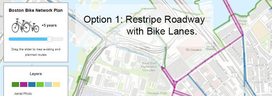
1 North Station Area Mobility Action Plan Photo: Landslides Aerial Photography ACTION PLAN PROPOSAL January 18, 2017

2 Agenda Process Review Outreach Shared Goals Existing Commitments Action Items Feedback Action Plan Proposal
3 Project Timeline (Adjusted) JUNE JULY Existing Conditions and First Public Meeting JULY SEPTEMBER Goals and Vision SEPTEMBER NOVEMBER Develop and Analyze Potential Improvements OCTOBER FEBRUARY Incorporating Public Feedback into Action Plan, including design for top 1 to 3 FEBRUARY Draft Action Plan for Public Comment MARCH Final Action Plan
4 Overview of Public Meetings (Adjusted) Late June: Define the Problems and Share Your Visions and Ideas July-September: Establish Shared Goals, Develop Strategies, and Vision September: Review Future Conditions and Brainstorm List of Potential Action Items and Gather Feedback October - November: Prioritize Options using Shared Goals (Benefits), Feasibility and Cost TODAY: Approve Action Item Mix, Discuss One to Three Immediate Design Alternatives February: Introduce Draft Action Plan and Collect Feedback
5 Development and Infrastructure Projects
6 Infrastructure Improvement Commitments


7 Action Plan Develop a variety of improvements for all modes, identify community priorities, and prioritize projects for implementation based on vision, feasibility, and cost
8 Project Team City Team Boston Planning and Development Agency Boston Transportation Department Office of Neighborhood Services Public Works Department Consultant Team Howard Stein Hudson Transportation Engineering NBBJ Urban Design and Visioning Marlene Connor Associates - Transit
9 Updates Pedestrian Tunnel North Station to Orange Line Current Estimated Completion date is 11/1/18
10 Public Process Review Photo: Landslides Aerial Photography


11 Multiple Methods of Outreach

12 June: Public Meetings Begin Collecting Ideas and Problems Feedback Categories Enforcement of existing rules Improve wayfinding during construction Reduce demand for driving Manage high pedestrian volumes Reduce confusion across modes


13 August: Pop Up Sessions More Ideas and Problems 4-6pm Wed., 8/3 Thoreau Path 11-1pm Thurs., 8/4 Cambridge Street/Whole Foods 4-6pm Thurs., 8/4 Gov. Center Garage 8-10am Fri., 8/5 Canal at Valenti Way 4-6pm Thurs., 8/11 North Station


14 August: Pop Up Sessions Ideas and Problems

15 August-October: Wikimap Ideas and Problems 186 total pins dropped 248 detailed comments provided Top participants: West End 49 Charlestown 9 North End 7 Jamaica Plain - 5 Metro North Towns 27

16 August-October: Wikimap Ideas and Problems


17 September: Shared Goals Created Safety More Understandable More Choices Less Congestion
18 Concept Change Behavior and Reduce Congestion Fix Local Circulation Problems Offer More Choices Make Other Choices More Attractive Make Driving Less Necessary

19 Example Shared Mobility Benefits Calculator Source:
 The availability of bikeshare reduces congestion traffic congestion upwards of 4% within a neighborhood.")
20 Recent Shared Mode Findings The more people use shared modes, the more likely they are to use public transit, own fewer cars, and spend less on transportation overall. Shared Use Mobility Center (Interviews) The availability of bikeshare reduces congestion traffic congestion upwards of 4% within a neighborhood. Hamilton and Wichman, August 2015, data from Capital Bikeshare, Washington D.C.

21 September: Existing Development and Infrastructure Projects
22 September: Existing Development and Infrastructure Projects
23 Over $9 Million in Off-Site Transportation Mitigation* Lovejoy Wharf - $2.5M + Water Shuttle Dock/Operations/Planning $1.5M 131 Beverly/160 N. Wash. $1M Boston Garden Water Taxi Dock 131 Beverly/160 N. Wash. Harborwalk & Connection to N. Wash. Bridge 131 Beverly/160 N. Wash. Causeway Street - $2.4M (Part of $12M+ Project) $437K One Canal $350K Nashua St Residences $300K The Merano $1M - Boston Garden $300K - The Victor (Simpson) Pedestrian Improvements to the Charles River Boston Garden North Station to Orange/Green Lines Connector Boston Garden Pedestrian Wayfinding $250K - Boston Garden Public Art & Open Space $2.6M - Boston Garden *Not Including Unknown $ or Gov t Center Garage
 TDM Programs Car Share/Ride Share/T Pass Subsidy Bike Parking On Site")
24 Over $9 Million in Off-Site Transportation Mitigation* NSAMAP Recommendations Implementation $1M Garden Garage Intersection/Signal Improvements Lomasney/Nashua St/Martha Rd. ~$350K Garden Garage Thoreau Path to Lomasney/Nashua St Garden Garage Other Site Specific (Not including sidewalks/public realm) TDM Programs Car Share/Ride Share/T Pass Subsidy Bike Parking On Site (secured/protected) Spaces Public Bike Racks Electric Vehicle (EV) Charging Stations Nashua St. Public Ped. Connection to N. Station Nashua St Residences Nashua St. Triangle Pedestrian Improvements Nashua St Residences Haymarket Station Improvements Gov t Center Garage Headhouse & Station Busway Bus Stop Improvements on Congress St Ped. Connections Other Gov t Center Garage Improvements *Draft Master TAPA Under Review *Each Project Phase Will Have Separate TAPA *Proposed Draft Framework of Improvements: 7 Intersection Improvement Locations 5 Signalization Improvement Locations Ped. Crossing Improvements at New Chardon/Bowker Streets Evaluate/Implement Bike Accommodations Congress St New Chardon St New Sudbury St *Not Including Unknown $ or Gov t Center Garage
25 November: Creation of Action Items Existing Projects Estimate Costs Community- Suggested Action Items (from Ideas & Problems) Other Jurisdictions Combine Remaining Items Addition of Emerging Best Practices Estimate Durations NSAMAP Action Items Feasibility Test Estimate Impacts

26 November: Polling on Action Items

27 Nov Dec: Online Ranking of Action Items
28 Feedback Motorized Traffic Public Meeting Poll Results Pts Lomasney Way/Nashua St/Martha Rd Intersection Improvements Near, Long Term 1275 Don t Block the Box Markings and Signage at Key Locations 825 Bulfinch Triangle Traffic Circulation Improvements 650 West End Signal timing Improvement Project 600 Adaptive Signal Technology Study 425 Residential Permit for Neighborhood Access During TD Garden Events 425 Encourage Employers to form Partnerships for TDM, Perform Annual TDM Reporting 425 New Signal for Left Hand Turn into Charles River Plaza 150 Online Ranking Poll Results Rank Adaptive Signal Technology Study 3.79 West End Signal Timing Improvement Project 3.83 Encourage Employers to form Partnerships for TDM, Perform Annual TDM Reporting 4.11 Don t Block the Box Markings and Signage at Key Locations 4.22 Lomasney Way/Nashua St/Martha Rd Intersection Improvements Near, Long Term 4.23 New Signal for Left Hand Turn into Charles River Plaza 5.36 Bulfinch Triangle Traffic Circulation Improvements 4.64 Residential Permit for Neighborhood Access During TD Garden Events 5.83
29 Feedback Transit Public Meeting Poll Results Total Points Lovejoy Wharf Ferry 2100 Consolidation of local MBTA routes, shuttles, tourist bus loop/shuttle stop consolidation study 950 North Washington Street Inbound Transit Lane to Haymarket 900 Airport Shuttle from North Station 600 Bus Priority Lane Connections N. Station Area to S. Boston 575 North Washington Bus Stop Improvements Project 450 Create Public Transit App Kiosks at Major MBTA Stations 375 Online Ranking Poll Results Avg. Rank Bus Priority Lane Connections N. Station Area to S. Boston 2.77 Airport Shuttle from North Station 3.55 North Washington Street Inbound Transit Lane to Haymarket 3.57 Consolidation of local MBTA routes, shuttles, tourist bus loop/shuttle stop consolidation study 3.97 Lovejoy Wharf Ferry 4.52 North Washington Bus Stop Improvements Project 4.53 Create Public Transit App Kiosks at Major MBTA Stations 5.08
30 Feedback Shared Mobility Public Meeting Poll Results Total Points North Station Mobility Hub Enhancements 200 Expand DriveBoston for New Carsharing Locations in the North Station Area, and Pilot One-Way Car Share 150 Online Ranking Poll Results Avg. Rank North Station Mobility Hub Enhancements 1.42 Expand DriveBoston for New Carsharing Locations in the North Station Area, and Pilot One-Way Car Share 1.58
31 Feedback Pedestrian Environment Public Meeting Poll Results Total Points Canal Street Pedestrianization 2100 Charles Circle Pedestrian Improvements 950 West End Sidewalk Improvement Project 675 West End Signal Timing Improvement Project 450 West End Pedestrian Crossing Improvements 350 West End Wayfinding Project 325 Cardinal O Connell Way Shared Street 200 Online Ranking Poll Results Avg. Rank Charles Circle Pedestrian Improvements 2.74 Canal Street Pedestrianization 3.05 West End Pedestrian Crossing Improvements 3.19 West End Sidewalk Improvement Project 4.15 West End Signal Timing Improvement Project 4.59 Cardinal O Connell Way Shared Street 4.81 West End Wayfinding Project 5.48
32 Feedback Placemaking Public Meeting Poll Results Total Points Bulfinch Triangle Tactical Urbanism Pilot 550 West End Chair Placements, Seating Improvements 525 Parklet on Blossom Street 150 Online Ranking Poll Results Avg. Rank Bulfinch Triangle Tactical Urbanism Pilot 1.56 West End Chair Placements, Seating Improvements 2.13 Parklet on Blossom Street 2.31
33 Feedback Flex Zone (Curb Use) Public Meeting Poll Results Total Points West End Dynamic/Increased Parking Pricing Pilot 575 Permitted Shuttle Stop Network 350 West End/Bulfinch Triangle Curb Use Reorganization 350 Parking Garage Wayfinding & Occupancy Data 175 Open data on Downtown Boston Parking Freeze 100 Online Ranking Poll Results Avg. Rank Permitted Shuttle Stop Network 2.42 West End Dynamic/Increased Parking Pricing Pilot 2.8 West End/Bulfinch Triangle Curb Use Reorganization 2.93 Parking Garage Wayfinding & Occupancy Data 3.37 Open data on Downtown Boston Parking Freeze 3.48


34 Feedback Bicycles Public Meeting Poll Results Pts Cambridge Street Protected Bike Lane 2100 Lomasney Way/Nashua Street Protected Bike Lane 950 Merrimac/Congress Street Protected Bike Lane 900 Connect both sides of Longfellow Bridge to Esplanade via Existing Tunnel 600 Charles Street Protected Bike Lane 575 Blossom Street Road Diet & Bike Lane 450 West End Hubway Expansion 375 West End Expansion of Boston s Bicycle Wayfinding System 325 Bike Parking in the Bulfinch Triangle 100 Online Ranking Poll Results Rank Cambridge Street Protected Bike Lane 3.43 Merrimac/Congress Street Protected Bike Lane 3.71 Lomasney Way/Nashua Street Protected Bike Lane 4.01 Charles Street Protected Bike Lane 4.08 Connect both sides of Longfellow Bridge to Esplanade via Existing Tunnel 4.7 Blossom Street Road Diet & Bike Lane 5.81 West End Hubway Expansion 6.27 West End Expansion of Boston s Bicycle Wayfinding System 6.68 Bike Parking in the Bulfinch Triangle 6.31
35 Action Plan Short Term Photo: Landslides Aerial Photography

36 Short Term Motorized Traffic Encourage Local Employers to Report Annually on their own TDM Goals Adaptive Signal Technology Study

37 Short Term Flex Zone (Curb Use) Performance-Based Meter Pricing
38 Bulfinch Triangle Existing Bulfinch Triangle Existing Circulation

39 Lomasney/Nashua Intersection New Signal and potential to re-imagine the intersection.


40 Don t Block the Box Process New police cadets enforce signage, report back to determine need for markings. Step 1: Step 2: Step 3 (if needed):


41 TDM from Local Employers? Encourage More Local Employers to perform TDM and Report Annually to the City. (Including TD Garden)

")
42 West End Signal Retiming (2 Signals)
 use. To a lesser degree, adjusting parking pricing also has a significant effect on SOV use.")
43 Performance-Based Meter Pricing Studies have shown that managing parking supply (reducing the number of spaces) can significantly lower Single Occupancy Vehicle (SOV) use. To a lesser degree, adjusting parking pricing also has a significant effect on SOV use. Source: FHWA

44 Adaptive Signal Technology Study Already underway in the city as part of new development. AST can help shorten the peak period impacts by better managing signal timings before and after the heaviest traffic time. It is not a magic bullet, but can reduce delay in the off-peak hours. AST can be expensive compared to conventional systems. AST can be helpful during special events.

45 Short Term Transit & Shared Mobility

46 North Washington St Bus Lane
47 Shuttle Consolidation Seaport

48 Bulfinch Triangle Shuttle Stop

49 Shuttle Stop Permitting SF Example Citywide formalization of shuttle stops. Permits are required for their use by operators (these may or may not also be MBTA stops). To get a permit, shuttle operator must give the city access to GPS tracking for monitoring. A cost is set for each stop a shuttle operator makes at a designated shuttle stop, and this cost supports the monitoring of shuttles at the city. Operator estimates frequency, monitoring is used to make adjustments annually.

50 Shuttle Consolidation EZ Ride

51 MBTA Ferry at Lovejoy Wharf

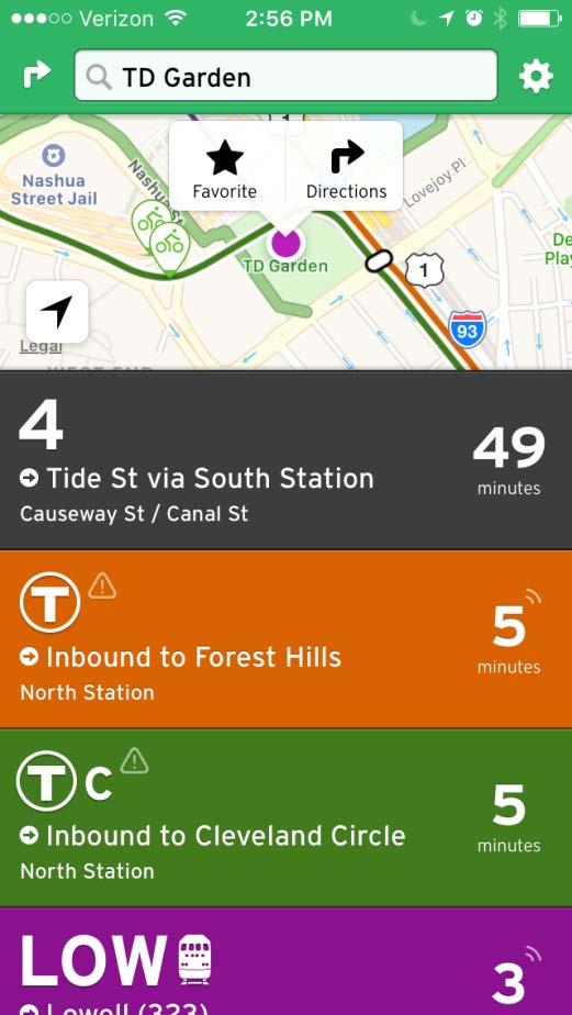
52 Interactive Transit Screens

53 N. Station Airport Shuttle
 Open Canal Street")
54 Short Term Pedestrian Environment Bulfinch Triangle Tactical Urbanism Pilot (Partial) Open Canal Street
55 Bulfinch Triangle Pedestrian Evolution

56 West End Signal Retiming (2 Signals)

57 Short Term Bicycles

58 Lomasney/Nashua Bikeway
59 Short Term Highlights Eleven Top-Ranked Action Items Charles Circle Pedestrian Improvements West End Signal Retiming West End Dynamic Parking Pilot Lomasney/Nashua Protected Bike Lane North Washington Street Bus Lane Adaptive Signal Technology Study Lomasney/Nashua Intersection Improvements (traffic and peds) Don t Block the Box Markings TDM Commitments Bulfinch Triangle Traffic Circulation Create Public Transit App Kiosks at North Station Six More Top-Ranked Action Items Partially addressed Canal Street Pedestrianization (process begins) Bulfinch Tactical Urbanism West End Wayfinding Permitted Shuttle Stop Network North Station Mobility Hub Bulfinch Triangle Curb Use Reorganization
60 Action Plan Long Term Photo: Landslides Aerial Photography


61 Long-Term Action Items Shuttle Consolidation
62 Long Term Highlights Seven Additional Action Items addressed Canal Street Pedestrianization Cambridge Street Bike Lane Congress/Merrimac Bike Lanes MBTA/Shuttle/Tourist Trolley Consolidation North Station-South Station Bus Priority Lane Lovejoy Wharf Ferry North Station-Logan Airport Shuttle Four Wider Changes Recommended Citywide Annual Reporting and Goal Setting Process for TDM Citywide Shuttle Stop Permitting Citywide Commercial Parking Revenue Collection Increase Shared Mobility Options
63 Immediate Design / Planning 1 Bulfinch Triangle Photo: Landslides Aerial Photography
64 Goals for Bulfinch Triangle Bulfinch Traffic Circulation Difficult Make it Easier to Navigate by Car Canal Foot Traffic to increase by 50% or more Make Canal More Pedestrian Oriented Shuttles Causing Congestion Put them in a Nice Place Off of Causeway Street
65 Limitations for Bulfinch Triangle Prevent Significant Cut- Through Traffic Prevent Certain Moves (Such as Highway Access) Truck Delivery and Other Uses are Still Needed for Canal Design a Shared Street Speedy Shuttles Help Keep Cars Off the Road Make Sure Shuttle Circulation is Simple
66 Bulfinch Triangle Existing Bulfinch Triangle Existing Circulation

67 Bulfinch Triangle Concept A

68 Bulfinch Triangle Concept B

69 Shuttle Stop Relocation

70 Shuttle Circulation Concept 1

71 Existing Curb Use

72 16 th Street Mall Shuttles and Peds


73 Parklets for Evolving the Streetscape

74 Parklets for Evolving the Streetscape

75 Parklets for Evolving the Streetscape Boston Garden Commercial Delivery Shuttle Stop Bicycle Parking Seasonal Dining Limited Parking Flex Zone

76 Open Canal Street

77 Immediate Design / Planning 2 Charles Circle Photo: Landslides Aerial Photography

78 Longfellow Plans

79 Charles Circle Ped. Improvements

80 Charles Circle Ped. Improvements

81 Charles Circle Ped. Improvements
82 Discussion
83 Future AM Volumes
84 Preferred AM Volumes
85 Future PM Volumes
86 Preferred PM Volumes
North Station Area Mobility Action Plan Draft Action Item List & Appendices
 North Station Area Mobility Action Plan Draft Action Item List & Appendices The following list of Draft Action Items was prepared from a much larger list of community suggestions collected from public
El Centro Mobility Hub
 The El Centro drive shed comprises a major portion of the El Centro downtown area, which is well served by bus routes. The proposals intend to promote use of public transit through improvements and enhancements
Ann Arbor Downtown Street Plan
 1 Ann Arbor Downtown Street Plan Public Workshop #1 We know that. 2 Public right-of-way (streets, sidewalks, and alleys) make up 30% of the total District area of downtown. Streets need to provide mobility
Tunnel Reconstruction South 5 th Street Association October 16, 2018
 Tunnel Reconstruction South 5 th Street Association October 16, 2018 Reconstructing the Tunnel 2 Service During Tunnel Reconstruction April 2019 through July 2020 3 Projected Cross River Travel Paths of
WELCOME. City of Greater Sudbury. Transportation Demand Management Plan
 WELCOME City of Greater Sudbury Transportation Demand Management Plan Public Consultation Session St. Andrew s Place, Activity Hall 111 Larch Street Wednesday September 13, 2017 6:00 to 8:00 pm Welcome
NEWMARKET UPHAM S CORNER
 SOUTH STATION Planning Initiative NEWMARKET UPHAM S CORNER COLUMBIA ROAD (P) FOUR CORNERS/GENEVA Working Advisory Group (WAG) Meeting #5 TALBOT AVENUE MORTON STREET BLUE HILL AVE/CUMMINS HWY (P) RIVER
CONCERNS / CHALLENGES
 CONCERNS / CHALLENGES Time frame Transit Pedestrian Access & Comfort Bicycle Access & Comfort Neighborhood Spillover Public Info & Signange Connection to Downtown Physical Contraints of site 0-5 years
Data Analysis February to March Identified safety needs from reported collisions and existing travel patterns.
 Welcome! Thank you for participating in today s Valencia Bikeway Improvements workshop. Data Analysis February to March Identified safety needs from reported collisions and existing travel patterns. Initial
PRINCE GEORGE S PLAZA METRO AREA PEDESTRIAN PLAN
 PRINCE GEORGE S PLAZA METRO AREA PEDESTRIAN PLAN May 28, 2008 Agenda Welcome and introductions Project overview and issue identification Planning context and strengths Design challenges and initial recommendations
Outreach Approach RENEW SF served as the primary liaison with the North Beach community; the Chinatown. Executive Summary
 Executive Summary Executive Summary The Columbus Avenue Neighborhood Transportation Study s objective is to identify changes to transportation infrastructure and policies that could enhance the livability
Agenda. Overview PRINCE GEORGE S PLAZA METRO AREA PEDESTRIAN PLAN
 PRINCE GEORGE S PLAZA METRO AREA PEDESTRIAN PLAN May 28, 2008 Agenda Welcome and introductions Project overview and issue identification Planning context and strengths Design challenges and initial recommendations
Solana Beach Comprehensive Active Transportation Strategy (CATS)
") Solana Beach Comprehensive Active Transportation Strategy (CATS) 3.0 Goals & Policies The Solana Beach CATS goals and objectives outlined below were largely drawn from the Solana Beach Circulation Element
Solana Beach Comprehensive Active Transportation Strategy (CATS) 3.0 Goals & Policies The Solana Beach CATS goals and objectives outlined below were largely drawn from the Solana Beach Circulation Element
BALBOA AREA: TRANSPORTATION PROJECTS & PLANNING
 BALBOA AREA: TRANSPORTATION PROJECTS & PLANNING TRANSPORTATION FOR ALL AGES, ABILITIES & MEANS CHANGING PATTERNS: TRENDING TO WALKING, BIKING, TRANSIT San Francisco s Change in Number of Commuters by Mode
Data Analysis February to March Identified safety needs from reported collisions and existing travel patterns.
 Welcome! Thank you for participating in today s Valencia Bikeway Improvements workshop. Data Analysis February to March Identified safety needs from reported collisions and existing travel patterns. Initial
PEDESTRIAN ACTION PLAN
 ATTACHMENT 2 CITY OF SANTA MONICA PEDESTRIAN ACTION PLAN CITY OF SANTA MONICA PEDESTRIAN ACTION PLAN This page intentionally left blank EXECUTIVE SUMMARY CHAPTER 1 EXECUTIVE SUMMARY Setting the Stage
Bicycle Master Plan Goals, Strategies, and Policies
 Bicycle Master Plan Goals, Strategies, and Policies Mobilizing 5 This chapter outlines the overarching goals, action statements, and action items Long Beach will take in order to achieve its vision of
North Shore Transportation Improvement Strategy
 North Shore Transportation Improvement Strategy Preliminary, Near-term Recommendation 2016 April Transportation Improvement Strategy (TIS) Comprehensive and Analytical A multi-modal transportation strategy
MASTER BICYCLE AND PEDESTRIAN PLAN
 VILLAGE OF NORTHBROOK MASTER BICYCLE AND PEDESTRIAN PLAN DRAFT PLAN OPEN HOUSE May 2, 2018 AGENDA 1. Community Engagement 2. Vision and Goals 3. General Structure of Plan 4. Recommendations Overview 5.
Environment and Public Works Committee Presentation
 Mixed Use Centers Complete Streets Guidelines Project Environment and Public Works Committee Presentation December 10, 2008 Project Objectives: Conduct an inter-departmental and agency process to study
Washington DC Section of ITE Project Briefing
 Washington DC Section of ITE Project Briefing November 5, 2015 Renée Hamilton, VDOT, Deputy District Administrator I-66 Outside the Beltway Improvement Area Project Location Virginia 2 Purpose and Need
Tunnel Reconstruction Brooklyn CB 1 August 14, 2018
 Tunnel Reconstruction Brooklyn CB 1 August 14, 2018 Reconstructing the Tunnel 2 Service During Tunnel Reconstruction April 2019 through July 2020 3 Projected Cross River Travel Paths of Customers The Service
TRANSPORTATION IMPROVEMENT STRATEGY
 TRANSPORTATION IMPROVEMENT STRATEGY A Vision for Staten Island North Shore November 2016 1 EXISTING CONDITIONS Transit Conditions MTA Bus Staten Island Railroad Peak Directional Traffic Volume (per hour)**:
Data Analysis February to March 2018 Identified safety needs from reported collisions and existing travel patterns. SFMTA Board of
 Welcome! Thank you for participating in today s Valencia Data Analysis February to March 2018 Identified safety needs from reported collisions and existing travel patterns. First Community Event(s) July
Hennepin County Bicycle and Pedestrian Planning
 Hennepin County Bicycle and Pedestrian Planning 1 Value of bicycle and sidewalk systems Safety Livability Mobility Health Personal Finances Economic Sustainability Clean Air Recreation Parking and congestion
Advancing Transportation Choices in Des Moines. MPO Environmental Roundtable January 9, 2018
 Advancing Transportation Choices in Des Moines MPO Environmental Roundtable January 9, 2018 Presented by Jennifer McCoy, PE, PTOE City Traffic Engineer Agenda Des Moines Area Transportation Planning Connect
2. Vision & Goals. Vision. Santa Rosa is a community where walking and bicycling are comfortable and convenient for people of all ages and abilities.
 2. Vision & Goals Overview The goals of the Santa Rosa Bicycle and Pedestrian Master Plan Update reflect the priorities expressed by the community throughout the public outreach phase of this Plan Update.
North Coast Corridor:
 North Coast Corridor: Connecting People, Transportation & Environment Legislative Hearing: 11.8.10 1 North Coast Corridor Region s Lifeline A Regional Strategy Mobility, Economy & Environment North Coast
Welcome! Public Open House on UBC s Transportation Plan
 1 Welcome! Public Open House on UBC s Transportation Plan Public open house hours: to When it comes to on-campus transportation, what do you think is working well and what are some opportunities for improvement?
 MEMORANDUM - CITY OF PASADENA Department Of Transportation DATE: OCTOBER 21, 2008 TO: ENVIRONMENTAL ADVISORY COMMISSION FROM: ~ FRED C. DOCK, DIRECTOR OF TRANSPORTATION SUBJECT: UPDATE ON DEPT. OF TRANSPORTATION
Bicycle and Pedestrian Advisory Committee (BPAC) November 21, 2013
 November 21, 2013") Bicycle and Pedestrian Advisory Committee (BPAC) November 21, 2013 OVERALL LAND USE CONCEPT Overall Broadway Valdez District: 95.5 acres (35.1 acres right-of ways + 60.4 acres developable land) Plan Subareas:
Bicycle and Pedestrian Advisory Committee (BPAC) November 21, 2013 OVERALL LAND USE CONCEPT Overall Broadway Valdez District: 95.5 acres (35.1 acres right-of ways + 60.4 acres developable land) Plan Subareas:
WELCOME. Purpose of the Open House. Update you on the project. Present a draft recommended plan. Receive your input
 WELCOME Purpose of the Open House The Town of Smiths Falls has initiated the Beckwith Street Redevelopment Plan that includes the preparation of a streetscape functional design for the renewal of Beckwith
Technical Working Group November 15, 2017
 Technical Working Group November 15, 2017 Welcome and Introductions Project Partners Regional Transportation District (RTD) Colorado Department of Transportation (CDOT) Denver Regional Council of Governments
TRAVEL PLAN: CENTRAL EUROPEAN UNIVERSITY CAMPUS REDEVELOPMENT PROJECT TRAVEL PLAN. Central European University Campus Redevelopment Project.
 TRAVEL PLAN Central European University Campus Redevelopment Project Page 1 Table of Contents Introduction... 3 Background... 7 Building Users... 7 Transportation in Community Consultation... 7 Summary
Moving Cambridge. City of Cambridge Transportation Master Plan Public Consultation Centre. March 7, :00 8:00 PM.
 City of Cambridge Transportation Master Plan Public Consultation Centre March 7, 2018 5:00 8:00 PM Region of Waterloo City of Cambridge Transportation Master Plan Public Consultation Centre March 7, 2018
Better Market Street Project Update. Urban Forestry Council September 17, 2014
 Better Market Street Project Update Urban Forestry Council September 17, 2014 Project Area Limits Better Market Street Schedule Market Street City s busiest transit corridor Over 85 buses per hour 14 surface
Transportation Assessment
 Transportation Assessment Midtown Open House February 10, 2018 Overview Midtown in Focus Overview & Purpose of Today Transportation Assessment overview Summary of Transportation work to date Review & Analysis
Proposed. City of Grand Junction Complete Streets Policy. Exhibit 10
 Proposed City of Grand Junction Complete Streets Policy Exhibit 10 1 City of Grand Junction Complete Streets Policy Vision: The Complete Streets Vision is to develop a safe, efficient, and reliable travel
Transportation, Parking & Roads
 Transportation, Parking & Roads Design Carolina North as a walkable community Design the transportation system and development patterns (i.e., urban design elements such as density, building design, mix
Community Task Force November 15, 2017
 Community Task Force November 15, 2017 Welcome and Introductions Project Partners Regional Transportation District (RTD) Colorado Department of Transportation (CDOT) Denver Regional Council of Governments
Sustainable Transportation Initiatives and Plans in Caledon
 Sustainable Transportation Initiatives and Plans in Caledon Arash Olia, P.Eng., PhD. Coordinator, Transportation Development Finance & Infrastructure Services Town of Caledon Eric Chan, P.Eng., PMP Manager,
CHAPTER 7 OF THE COMPREHENSIVE PLAN TRANSPORTATION Mobility for all Modes
 CHAPTER 7 OF THE COMPREHENSIVE PLAN TRANSPORTATION 2030 Adopted xxx, xx, xxxx Mobility for all Modes Chapter 7, Page 0, Draft version 48 Context and Vision Why Automobiles Alone are not the Answer Because
C C C
 C-012-001 Thank you for your support for the creation of new public space and nonmotorized access between downtown and the waterfront through the Overlook Walk, the East-West Connections, and the Promenade.
In station areas, new pedestrian links can increase network connectivity and provide direct access to stations.
 The Last Mile Planning for Pedestrians Planning around stations will put pedestrians first. Making walking to stations safe and easy is important; walking will be a part of every rapid transit Accessible
Prince George s County plans, policies, and projects
 Prince George s County plans, policies, and projects Over 250 projects for trails, bikeways, designated bike lanes and sidewalk construction Trail projects that improve access to Metro Sidewalk and trail
CTDOT Pedestrian and Bicycle Safety Initiatives
 CTDOT Pedestrian and Bicycle Safety Initiatives 2017 Northeast Transportation Safety Conference Mark F. Carlino, P.E. Traffic Engineering Division Chief Bureau of Engineering and Construction Connecticut
Roadways. Roadways III.
 Introduction 97 Roadway Design Principles 98 Safe Speeds 99 Optimizing of Street Space 00 Minimum Lane Widths in the City of Boston 02 Design Features that Reduce Operating Speeds 05 Travel Lanes Transit
CITY OF COCOA BEACH 2025 COMPREHENSIVE PLAN. Section VIII Mobility Element Goals, Objectives, and Policies
 CITY OF COCOA BEACH 2025 COMPREHENSIVE PLAN Section VIII Mobility Element Goals, Objectives, and Policies Adopted August 6, 2015 by Ordinance No. 1591 VIII MOBILITY ELEMENT Table of Contents Page Number
PEDALING FORWARD. A Glance at the SFMTA s Bike Program for SFMTA.COM
 PEDALING FORWARD A Glance at the SFMTA s Bike Program for 2017-2021 SFMTA.COM INTRODUCTION About This Booklet More people from all walks of life see their bicycle as a more convenient way to get where
Omaha s Complete Streets Policy
 Omaha s Complete Streets Policy (Adopted August 2015) VISION To create great places and enhance our quality of life, the City of Omaha will provide safe, accessible streets for all users. Complete Streets
CONNECTIVITY PLAN. Adopted December 5, 2017 City of Virginia Beach
 CONNECTIVITY PLAN Adopted December 5, 2017 City of Virginia Beach CONTENTS 1.0 Background & Purpose... 2 2.0 Existing Inventory & Analysis... 3 ViBe District Existing Walking Conditions... 4 3.0 ViBe District
HARRISON STREET/OAKLAND AVENUE COMMUNITY TRANSPORTATION PLAN
 HARRISON STREET/OAKLAND AVENUE Community Workshop #4: Draft Plan Review December 3, 2009 D E S I G N, C O M M U N I T Y & E N V I R O N M E N T INTRODUCTIONS Key Project Staff: Alisa Shen, Project Manager,
Complete Streets: Policy Framework Complete Streets: Implementation Plans A more Complete Street: Laurier Bike Lane Pilot Project
 Complete Streets Initiatives City of Ottawa Complete Streets: Policy Framework Complete Streets: Implementation Plans A more Complete Street: Laurier Bike Lane Pilot Project Zlatko.Krstulic@Ottawa.ca May
Lincoln Neighborhood Corridor Plan The LiNC
 CITY OF SANTA MONICA Lincoln Neighborhood Corridor Plan The LiNC PLANNING COMMISSION September 2, 2015 COMMUNITY DESIGN + ARCHITECTURE TEAM: Community Design + Architecture Iteris Studio 111 Urban Place
Bridgewater Complete Streets Prioritization Plan and Pedestrian Safety Assessment
 Bridgewater Complete Streets Prioritization Plan and Pedestrian Safety Assessment Presented by Luciano Rabito Manager of Complete Streets Presented to Bridgewater, MA Wednesday, April 26, 2017 6:30 P.M.
Chapter 2. Bellingham Bicycle Master Plan Chapter 2: Policies and Actions
 Chapter 2 Bellingham Bicycle Master Plan Chapter 2: Policies and Actions Chapter 2: Policies and Actions The Bicycle Master Plan provides a road map for making bicycling in Bellingham a viable transportation
Walkable Community Workshops
 Presented by: Larry McAuliffe Manager, Research Unit, Planning Division New York Metropolitan Transportation Council NYSMPO Conference 2008 Walkable Community Workshops Discussion Topics: I. NYMTC in the
CHAPTER 7.0 IMPLEMENTATION
 CHAPTER 7.0 IMPLEMENTATION Achieving the vision of the Better Streets Plan will rely on the ability to effectively fund, build and maintain improvements, and to sustain improvements over time. CHAPTER
Thoreau Path Master Plan Final Draft. prepared for: The Boston Redevelopment Authority West End Community November 2007
 Thoreau Path Master Plan Final Draft prepared for: The Boston Redevelopment Authority West End Community November 2007 Introduction Carol R. Johnson Associates ( CRJA ) was retained by the Boston Redevelopment
STONY PLAIN ROAD STREETSCAPE
 Jasper Place Revitalization Strategy: Vision The people involved in the Jasper Place Revitalization Strategy envision: Goal 1: Feeling safe in our community Create a community where feeling safe is common--where
Community Task Force March 14, 2018
 Community Task Force March 14, 2018 Welcome and Introductions Project Partners Regional Transportation District (RTD) City of Aurora Colorado Department of Transportation (CDOT) Denver Regional Council
WELCOME! To the Centennial Neighbourhoods Secondary Plan and Transportation Management Plan Information Centre. City of Hamilton
 WELCOME! To the Centennial Neighbourhoods Secondary Plan and Transportation Management Plan Information Centre City of Hamilton Public Information Centre #2 Dec 1, 2015 CENTENNIAL NEIGHBOURHOODS SECONDARY
Better Market Street. Engineering, Maintenance & Safety Committee (EMSC) February 28, 2018
 February 28, 2018") Better Market Street Engineering, Maintenance & Safety Committee (EMSC) February 28, 2018 1 Market Street Market Street - San Francisco by rulenumberone2 2 Market Street is the... City s busiest pedestrian
Better Market Street Engineering, Maintenance & Safety Committee (EMSC) February 28, 2018 1 Market Street Market Street - San Francisco by rulenumberone2 2 Market Street is the... City s busiest pedestrian
Upper Market Street Bike Lane Project
 Upper Market Street Bike Lane Project 17th Street to Octavia Boulevard 6 30 2010 SAN FRANCISCO, CALIFORNIA Agenda San Francisco & Sustainable Transportation Project Goals Outreach & Coordination Project
TRANSIT & NON-MOTORIZED PLAN DRAFT FINAL REPORT Butte County Association of Governments
 1 INTRODUCTION Maintaining a high quality of life is the essence of this plan for transit and non-motorized transportation in Butte County. Curbing greenhouse gas emissions (GHG) by reducing congestion,
EXECUTIVE SUMMARY... vii 1 STUDY OVERVIEW Study Scope Study Area Study Objectives
 Contents EXECUTIVE SUMMARY... vii 1 STUDY OVERVIEW... 1-1 1.1 Study Scope... 1-1 1.2 Study Area... 1-1 1.3 Study Objectives... 1-3 2 EXISTING CONDITIONS... 2-1 2.1 Existing Freeway Conditions... 2-4 2.1.1
GRTC Bus Rapid Transit: Semi-Final Design Phase Public Meetings: October 26 & 27, 2015
 GRTC Bus Rapid Transit: Semi-Final Design Phase Public Meetings: October 26 & 27, 2015 Welcome! Meeting Agenda Project update presentation Up to 15 minutes for Pulse Q&A about project design. (Please reserve
ACTIA Programs Annual Compliance Report Reporting Year Bicycle and Pedestrian Safety Table 1: Summary of Expenditures and Accomplishments
 Bicycle and Pedestrian Safety Table 1: Summary of Expenditures and Accomplishments Note: Definitions for each drop down menu appear as Comments (scroll over the column title or in the Review mode, choose
Beyond First First Last Last Mile Strategies. APA National Conference April 3, 2016 Chelsea Richer, AICP Fehr & Peers
 Beyond First First Last Last Mile Strategies APA National Conference April 3, 2016 Chelsea Richer, AICP Fehr & Peers 1 Beyond First Last Mile Strategies APA National Conference Jeremy Klop, AICP, Fehr
BUILDING THE CASE FOR TRAVEL OPTIONS IN WASHING TON COUNTY. Image: Steve Morgan. Image: Steve Morgan
 BUILDING THE CASE FOR TRAVEL OPTIONS IN WASHING TON COUNTY Image: Steve Morgan Image: Steve Morgan Image: TriMet Image: TriMet WHAT ARE TRAVEL OPTIONS PROGRAMS? Travel options programs encourage residents,
Tonight is for you. Learn everything you can. Share all your ideas.
 Strathcona Neighbourhood Renewal Draft Concept Design Tonight is for you. Learn everything you can. Share all your ideas. What is Neighbourhood Renewal? Creating a design with you for your neighbourhood.
Living Streets Policy
 Living Streets Policy Introduction Living streets balance the needs of motorists, bicyclists, pedestrians and transit riders in ways that promote safety and convenience, enhance community identity, create
The five potential solutions and some of their benefits and costs are listed in the following table: Ferry Patron Bike Parking Alternatives
 STAFF REPORT City Council of the City of Sausalito AGENDA TITLE: Ferry Patron Bicycle Parking Plan - Summer 2014 RECOMMENDED MOTION: Note and file informational item, no action necessary SUMMARY In April
Working Group Meeting
 Working Group Meeting February 6, 2018 Parks and Natural Resources Operations Building Transportation Analysis Draft Policy Framework Agenda 7:05 pm Welcome 7:10 pm Follow-up from Previous Meetings Schedule
Bicycle and Pedestrian Plans and Improvements
 Bicycle and Pedestrian Plans and Improvements Presented to the City Council By Randle Harwood, Planning and Development, and Richard Zavala, Parks and Community Services September 24, 2013 Purpose Review
ALTERNATIVES TO BE CONSIDERED
 ALTERNATIVES TO BE CONSIDERED EXISTING CONDITIONS (BASE CASE) In order to evaluate and understand the potential benefits and impacts of introducing downtown transit improvements in Providence, a Base Case
Community Task Force July 25, 2017
 Community Task Force July 25, 2017 Welcome and Introductions Project Partners Regional Transportation District (RTD) Colorado Department of Transportation (CDOT) Denver Regional Council of Governments
Ulster County Non-motorized Transportation Plan
 Ulster County Non-motorized Transportation Plan NTAC Meeting NOTES Ulster County Community College Date 08.29.07 Time: 1:00 p.m. - 3:00 p.m. Agenda Welcome /Intro Project Status Report o Project is on
Pocatello Regional Transit Master Transit Plan Draft Recommendations
 Pocatello Regional Transit Master Transit Plan Draft Recommendations Presentation Outline 1. 2. 3. 4. What is the Master Transit Plan? An overview of the study Where Are We Today? Key take-aways from existing
Priority 1: Ala Wai Pedestrian and Bicycle Safety and Mobility Project
 Priority 1: Ala Wai Pedestrian and Bicycle Safety and Mobility Project The full application can be found here: http://www.oahumpo.org/wp-content/uploads/2015/05/alawai_application.pdf Description The Ala
Point Defiance Park. Master Plan
 Point Defiance Park Master Plan Public Participation 1/29, 2/26, 3/26 & 4/23 Owen Beach Ferry Zoo Fort Nisqually Mildred Street Pearl Street Triangle Hare & Hare Master Plan - 1911 2008 Concept Plan Comments
Dulles Area Transportation Association. October 11, Susan Shaw, P.E., Megaprojects Director Virginia Department of Transportation
 Dulles Area Transportation Association October 11, 2017 Susan Shaw, P.E., Megaprojects Director Virginia Department of Transportation Transform 66: Outside the Beltway 2 Project Overview Multimodal improvements
FY 2018 I-66 Commuter Choice Program Presentation to the Northern Virginia Transportation Commission May 3,
 FY 2018 I-66 Commuter Choice Program Presentation to the Northern Virginia Transportation Commission May 3, 2018 www.novatransit.o rg 703-524-3322 Presentation Overview I-66 Commuter Choice Program Overview
TRANSPORTATION TRAINING TOPICS. April 6, 2010
 TRANSPORTATION TRAINING TOPICS April 6, 2010 Roles of Transportation Providers Context and Policy Makers Division of Transportation and Traffic Other City Operations Other Transportation Operators CMA
Stakeholder Meeting Handouts. January 2013
 January 2013 Stakeholder Meeting Handouts The Case FOR Parking Minimum Requirements Reduce street congestion around the development site Avoid parking spillover Create orderly development patterns Anticipate
WELCOME. Traffic & Parking Commission Special Meeting May 30, Iteris, Inc. All rights reserved.
 WELCOME Traffic & Parking Commission Special Meeting May 30, 2018 WORKSHOP #2 CONCEPTS FOR IMPROVEMENT MAY 30, 2018 Agenda 1. Welcome 10 min 2. Project Presentation 25 min 3. Roundtable Dialogue 50 min
MCA Member Meeting: Tysons Update. Fairfax County Department of Transportation November 13, 2017
 MCA Member Meeting: Tysons Update Fairfax County Department of Transportation November 13, 2017 Presentation Overview Balancing Land Use and Transportation How Are We Doing? Studies and Projects Neighborhood
The Wiggle Route in Context
 The Wiggle Route in Context In a city of hills, the Wiggle is an important route because it winds its way along the flattest streets from Market to the Panhandle, bringing residents to local parks and
Better Market Street Project. Project Update January 15, 2015
 Better Market Street Project Project Update January 15, 2015 Better Market Street Project Area Limits Market Street 2.2 Miles Mission Street Better Market Street Schedule Market Street City s busiest transit
City of Hamilton s Transportation Master Plan (TMP) Public Consultation 3 December 2015
 Public Consultation 3 December 2015") City of Hamilton s Transportation Master Plan (TMP) Public Consultation 3 December 2015 McPhail Transportation Planning Services Ltd. AGENDA 6:00 7:00 pm Viewing Boards / Q & A with the Team 7:00 7:50
City of Hamilton s Transportation Master Plan (TMP) Public Consultation 3 December 2015 McPhail Transportation Planning Services Ltd. AGENDA 6:00 7:00 pm Viewing Boards / Q & A with the Team 7:00 7:50
Corpus Christi Metropolitan Transportation Plan Fiscal Year Introduction:
 Introduction: The Safe, Accountable, Flexible, Efficient Transportation Equity Act: A Legacy for Users (SAFETEA-LU) has continued the efforts started through the Intermodal Surface Transportation Efficiency
Prince George s County Council Retreat January 5, 2017
 Rushern L. Baker, III County Executive Darrell B. Mobley Director Prince George s County Council Retreat January 5, 2017 DPW&T STRUCTURE AND SERVICES Office of Transportation: Fixed route transit service
Bicycle Friendly Niagara Falls
 Bicycle Friendly Niagara Falls STAKEHOLDER COMMITTEE MEETING 2 SUPPORTED BY THE OATH COMMUNITY FUND AT THE COMMUNITY FOUNDATION FOR GREATER BUFFALO Develop a Bicycle Master Plan to document the city s
Appendix C 3. Bicycle / Pedestrian Planning
 Appendix C 3. Bicycle / Pedestrian Planning BICYCLE/PEDESTRIAN PLANNING 2005 Master Plan GOAL: Provide for safe and convenient bicycle and pedestrian circulation throughout the City. Develop a city-wide
Hamilton Transportation Master Plan Public Consultation. Public Information Centre One Summary
 Hamilton Transportation Master Plan Public Consultation Public Information Centre One Summary Table of Contents Introduction 1 Purpose 2 What Was Presented 2 Who Came to the Meeting 2 The Breakout Sessions
About the Active Transportation Alliance
 About the Active Transportation Alliance Chicagoland s voice for better biking, walking and transit Founded 1985 7,000 members, ~33 full time staff Serve Chicago metro region 1 More Cars, More Driving
Mayor s Bicycle Advisory Council. Wednesday, December 13 th, 2017
 Mayor s Bicycle Advisory Council Wednesday, December 13 th, 2017 Bicyclist Fatalities, Year to Date (January 1 November 30, 2017) - MBAC Briefing Bicyclist Fatality Statistics Year to date total, 2017
San Francisco Planning Department IPIC Report 2016
 San Francisco Planning Department IPIC Report 2016 and Expenditure Plan FY 2017 2018 San Francisco Planning Commission January 7, 2016 IMPLEMENTING OUR COMMUNITY PLANS The Plan Implementation Team manages
See Figure 38, Existing Nonmotorized Connections.
 Nonmotorized Connections Existing Nonmotorized Connections Pedestrian, vehicle and bike traffic access and movements are confined primarily to Penny Drive on campus. Due to the steep slope along the length
Freeway ramp intersection study
 Freeway ramp intersection study Supporting Vision Zero: Zero traffic deaths in San Francisco by 2024 Study Goals: Primary Improve Safety Improve Accessibility Secondary Provide Efficient Circulation Accommodate
City of Palo Alto Transportation Division Update
 Attachment 4 City of Palo Alto Transportation Division Update CAC Transportation Sub-Committee December 9, 20151 Agenda Transportation Project Updates Bike Program Update Parking Management Shuttle Re-Visioning